Annual Air Quality Monitoring Network Plan Alaska Department of Environmental Conservation
←
→
Page content transcription
If your browser does not render page correctly, please read the page content below
Public Notice Draft - 2021 Monitoring Network Plan

                                               2021
 Air Quality Division             Annual Air Quality
   Air Monitoring
          &                           Monitoring
  Quality Assurance
      Program
                                     Network Plan
 555 Cordova St., 1st Floor
  Anchorage, AK 99501
Phone: (907) 269-7577
  Fax: (907) 269-7508

www.dec.alaska.gov/air/          Alaska Department of
                              Environmental Conservation

                                   Public Comment Draft
                                       May 24, 2021

                                                                                      1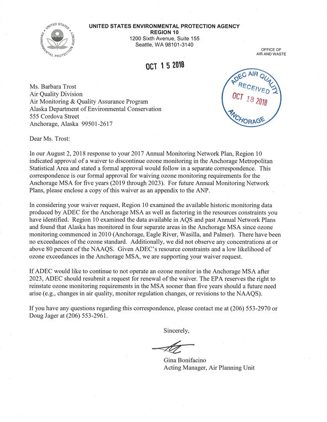
Public Notice Draft - 2021 Monitoring Network Plan

     TABLE OF CONTENTS

Table of Contents                                                                                                                           2
Table of Appendices                                                                                                                         3
List of Tables                                                                                                                              4
Executive Summary                                                                                                                           6
1    Introduction                                                                                                                           7
2    Air Quality Monitoring Priorities                                                                                                      8
3    State of Alaska Ambient Air Monitoring Network                                                                                         9
     3.1 Minimum Monitoring Requirements ................................................................................9
       3.1.1 Lead............................................................................................................................. 12
       3.1.2 Appendix D & E Siting Forms.................................................................................... 12
     3.2     Current Monitoring Sites ................................................................................................13
     3.3 Siting Criteria ..................................................................................................................14
       3.3.1 Carbon Monoxide Sites............................................................................................... 14
       3.3.2 Particulate Matter (PM10 and PM2.5) Sites .................................................................. 14
       3.3.3 NCore Site................................................................................................................... 17
     3.4     Monitoring Methods, Designation, and Sampling Frequency ........................................17
     3.5 Monitoring Waivers ........................................................................................................33
       3.5.1 Lead Source Oriented Monitoring .............................................................................. 33
       3.5.2 Harrison Ct (Butte) Siting ........................................................................................... 33
       3.5.3 Anchorage MSA Ozone Monitoring ........................................................................... 33
4.     Network Modifications completed in 2021                                                                                              34
     4.1     Gaseous Analyzer Replacement .....................................................................................34
     4.2     Particulate Matter Instrument Replacement....................................................................34
5.     Planned Network Modifications For 2022                                                                                               35
     5.1     Harrison Ct Site Study ....................................................................................................35
     5.2     Low-Cost Sensor Network ..............................................................................................35
     Smoke Monitoring for Air Quality Advisories ........................................................................56
     Volcanic Ash Monitoring ........................................................................................................56

                                                                                                                                                2
Public Notice Draft - 2021 Monitoring Network Plan

   Radiation Monitoring ...............................................................................................................56

        TABLE OF APPENDICES
Appendix A         Network Evaluation Forms                                                                                         36
Appendix B         Summary of Monitoring Path & Siting Criteria Evaluation Forms                                                    45
Appendix C         Additional Monitoring Projects                                                                                   55
Appendix D         Improve Network                                                                                                  57
Appendix E         NAAQS Summary Tables                                                                                             59
Appendix F         Map of Alaska’s Core Based Statistical Areas (CBSA)                                                              63
Appendix G         Waivers                                                                                                          66

                                                                                                                                       3
Public Notice Draft - 2021 Monitoring Network Plan

       LIST OF TABLES
Table 3-1: Alaska’s Core Based Statistical Areas                                                        10
Table 3-2: Minimum Monitoring Requirements for Alaskan CBSAs                                            11
Table 3-3: AQS Monitoring Sites as of May 2021                                                          13
Table 3-4: CO Monitoring Sites in Anchorage and Fairbanks as of May 2021                                14
Table 3-5: PM Monitoring Sites in Alaska as of May 2021                                                 16
Table 3-6: NCore Gaseous1 Monitoring and Meteorological Monitoring as of May 2021 in
Alaska                                                                               17
Table 3-7: Anchorage MSA: AQS Codes May 2021                                                            19
Table 3-8: FNSB monitors: AQS Codes as of May 2021                                                      20
Table 3-9: Juneau µSA: AQS Codes as of May 2021                                                         25
Table 3-10: Bethel: AQS Codes as of May 2021                                                            25
Table 3-11: May 2021 Site Level Monitoring Objectives                                                   26
Table 3-12: 2021 Anchorage MSA Instrument-Level Monitoring Purposes and AQS
Monitoring Objective                                                                                    27
Table 3-13: 2021 FNSB Instrument-Level Monitoring Purposes and AQS Monitoring
Objective                                                                                               28
Table 3-14: 2021 Juneau Instrument-Level Monitoring Purposes and AQS Monitoring
Objective                                                                                               31
Table 3-15: 2021 Bethel Instrument-Level Monitoring Purposes and AQS Monitoring
Objective                                                                                               31
Table 3-16: Monitors required by Nonattainment Area (NAA) or Limited Maintenance Plan
(LMP)                                                                                 32
Table 3-17: Collocations January 2021                                                                   32
Table 4-1: NCore Gaseous Equipment Replacements                                                         34
Table A-1 PM2.5 Network Evaluation Form                                                                 37
Table A-2 PM10 Network Evaluation Form                                                                  39
Table A-3 CO Site Evaluation Form                                                                       40
Table A-4 O3 Network Evaluation Form                                                                    41
Table A-5 SO2 Network Evaluation Form                                                                   43
Table A-6 NO2 Network Evaluation Form                                                                   44
Table B-1 Summary of Appendix E Forms: PM2.5, PM10, & PM10-2.5                                          46

                                                                                                          4
Public Notice Draft - 2021 Monitoring Network Plan

Table B-2 Summary of Appendix E Forms: CO                                                            47
Table B-3 Summary of Appendix E Forms: O3, SO2, NO, Diff, and NOy                                    48
Table B-4 Blank Part 58 Appendix E Form for PM                                                       49
Table B-5 Blank Part 58 Appendix E Form for CO                                                       50
Table B-6 Blank Part 58 Appendix E Form for O3                                                       51
Table B-7 Blank Part 58 Appendix E Form for SO2                                                      52
Table B-8 Blank Part 58 Appendix E Form for NO, NOx, NO2, and NOy                                    53
Table B-9 Roadway ADT for CO, O3, SO2, and NO suite Part 58 Appendix E Forms                         54
Table E-1 PM2.5 DV under local/actual conditions (µg/m3)                                             60
Table E-2 DV O3 (ppb)                                                                                61
Table E-3 DV SO2 (ppb)                                                                               61
Table E-4 DV CO (ppm)                                                                                61
Table E-5 PM10 DV under standard conditions (µg/m3)                                                  62
Waiver G-1 EPA 5-Year Ozone NAAQS Monitoring Requirement Waiver                                      66
Waiver G-2 Siting Requirement Waiver for Butte                                                       67
Waiver G-3 Red Dog Mine Lead Monitoring Waiver                                                       69

                                                                                                       5
Public Notice Draft - 2021 Monitoring Network Plan
EXECUTIVE SUMMARY
This 2021 Annual Monitoring Plan describes the Alaska air quality monitoring network under
the Alaska Department of Environmental Conservation’s (DEC) oversight and spells out
anticipated changes to the network for the calendar year 2022.
Most of the air monitoring activities are focused on population centers and areas that have shown
in the past to have air quality problems. Due to budget cuts over the past several years DEC
continues to reduce the ambient monitoring network to include only regulatory required sites.
Looking ahead, DEC does not expect to expand the network during the next several years due to
fiscal constraints.
The most significant changes to the network during 2021 were the update of the NCore gaseous
analyzers suite. In SFY 2020, DEC received state funding to replace the gaseous analyzers over
seven years of age in the network. The instrument swap out was delayed due to social distancing
requirements caused by the COVID -19 pandemic but was finally completed in spring of 2021.
Additionally, DEC will replace the Juneau particulate matter analyzers at the Floyd Dryden
Middle School site with a Teledyne T640X analyzer in 2021. The new instrument will combine
PM10 and PM2.5 measurements in one instrument. The PM2.5 Met One BAM 1020 analyzers at
the Fairbanks A-Street and Mat-Su Butte sites will be replaced with newer model Met One
BAMs, as will the PM10 BAM at the Eagle River Parkgate site.
There are currently no planned modifications for the 2022 regulatory network. In 2021/22 DEC
will continue the search for a substitute site location for the Harrison Ct. (Butte) site. Both DEC
and EPA have agreed to focus on two locations for further investigation. The DEC has initiated
negotiating with the property owners and plans to establish a temporary monitoring site at least
at one of the two locations, and if staffing and resources allow at both. The goal is to collect at
least one year of continuous PM2.5 data concurrently with the Harrison Ct site for long-term data
record comparison.
Additionally, DEC is starting a pilot project to expand air quality sensor technology to a select
number of hub communities throughout the state. The intent is to broaden coverage of air quality
monitoring, and to test the new ‘low-cost sensor’ technology. If the technology proves useful,
the new low-cost sensor network could be the first phase of a more extensive statewide network.
The low-cost sensor pods made by AQmesh and supplied by Ambilabs, were selected for the
pilot project. The sensor pods will collect baseline air quality data, including particulate matter
(PM), SO2, NO, NO2 and CO. Initially, DEC plans to set up 17 sensor pods in 13 communities
throughout Alaska. The communities selected for a sensor pod were chosen based on location,
interest, and population density. Installation of the AQmesh sensor pods in the communities will
begin in the summer of 2021 and DEC anticipates that it will take until 2022 to complete set up
in all of the communities.
6Public Notice Draft - 2021 Monitoring Network Plan
1 INTRODUCTION
The Code of Federal Regulations (CFR) Title 40 §58.10 requires each state agency to adopt and
submit to the U.S. Environmental Protection Agency (EPA) Regional Administrator an annual
monitoring network plan which shall provide for the establishment and maintenance of an air
quality surveillance system that consists of a network made up of the following types of
monitoring stations:
• State and local air monitoring stations (SLAMS), including monitors that are
designated as:
o Federal Reference Method (FRM), or
o Federal Equivalent Method (FEM)
• National Core Multi-Pollutant Monitoring Stations (NCore)
• PM2.5 Chemical Speciation Network (CSN), and
• Special Purpose Monitoring (SPM) stations
The plan shall include a statement of purpose for each monitor and evidence that siting and
operation of each monitor meets the requirements of appendices A, C, D, and E of 40 CFR 58
where applicable.
The annual monitoring network plan must be made available for public inspection for at least 30
days prior to submission to EPA. Any annual monitoring network plan that proposes SLAMS
network modifications, including new monitoring sites, is subject to the approval of the EPA
Regional Administrator, who shall provide opportunity for public comment and shall approve or
disapprove the plan and schedule within 120 days. If the State or local agency has already
provided a public comment opportunity on its plan and has made no changes subsequent to that
comment opportunity and has submitted the received comments together with the plan, then the
Regional Administrator is not required to provide a separate opportunity for comment.
This 2021 Annual Monitoring Network Plan describes the Alaska air quality monitoring network
under the State’s oversight and spells out anticipated changes to the network for the calendar
year 2021. This plan shall include all required stations to be operational by January 1, 2022.
Specific locations for the required monitors shall be included in the annual network plan which is
due to be submitted to the EPA Regional Administrator by July 1, 2021.
The annual monitoring network plan must contain the following information for each existing
and proposed site:
1. The AQS site identification number;
2. The location, including street address and geographical coordinates;
3. The sampling and analysis method(s) for each measured parameter;
4. The operating schedules for each monitor;
5. Any proposals to remove or move a monitoring station within a period of 18 months
following plan submittal;
7Public Notice Draft - 2021 Monitoring Network Plan
6. The minimum monitoring requirements for spatial scale of representativeness for each
monitor as defined in 40 CFR 58, Appendix D;
7. The minimum monitoring requirements for probe and monitoring path siting criteria as
defined in 40 CFR 58, Appendix E;
8. The identification of any sites that are suitable and sites that are not suitable for
comparison against the annual PM2.5 NAAQS as described in 40 CFR 58.30;
9. The Metropolitan Statistical Area, Core-Based Statistical Area, Combined Statistical
Area or other area represented by the monitor;
10. The designation of any lead monitors as either source-oriented or non-source-oriented
according to 40 CFR 58, Appendix D;
11. Any source-oriented monitors for which a waiver has been requested or granted by the
EPA Regional Administrator as allowed for under paragraph 4.5(a)(ii) of 40 CFR 58,
Appendix D; and
12. Any source-oriented or non-source-oriented site for which a waiver has been requested
or granted by the EPA Regional Administrator for the use of Pb-PM10 monitoring in
lieu of lead total suspended particulate (Pb-TSP) monitoring as allowed for under
paragraph 2.10 of 40 CFR 58, Appendix C.
2 AIR QUALITY MONITORING PRIORITIES
In 1970 the Congress of the United States created the U.S. Environmental Protection Agency
(EPA) and promulgated the Clean Air Act (CAA). Title I of the CAA established National
Ambient Air Quality Standards (NAAQS) to protect public health. NAAQS were developed for
six criteria pollutants: particulate matter (PM), sulfur dioxide (SO2), nitrogen dioxide (NO2),
carbon monoxide (CO), ozone (O3), and lead (Pb). Particulate matter has two associated
NAAQS: one for fine particulate matter less than 2.5 micrometers in aerodynamic diameter
(PM2.5) and one for coarse particulate matter less than 10 micrometers in aerodynamic diameter
(PM10). Threshold limits established under the NAAQS to protect human health are known as
primary standards. The primary health standards are to protect the most sensitive of the human
population, including those people with existing respiratory or other chronic health conditions,
children, and the elderly. Secondary standards established under the NAAQS are to protect the
public welfare and the environment. Since promulgation of the original CAA, the EPA has
continued to revise the NAAQS based on its assessment of national air quality trends and on
current (and ongoing) health studies.
To protect public health and assess compliance with NAAQS, DEC established an air quality
monitoring program. The State of Alaska has a large geographical area with a small population.
Anchorage and the Matanuska-Susitna (Mat-Su) Valley have the bulk of the 731,545 1 residents
in the state, about 54% of the overall population. The remainder of the population is distributed
1
Based on population estimates for July 1, 2019 obtained from the United States Census Bureau,
https://www.census.gov/quickfacts/fact/table/US/PST045219
8Public Notice Draft - 2021 Monitoring Network Plan
among the cities of Juneau and Fairbanks, both with populations of just over 30,000 residents,
and many scattered and isolated small villages, most of which are off the road system and have
populations ranging from 16 to 10,000 people. The total land area of the state is approximately
570,641 square miles (1.5 million square kilometers) 2.
In accordance with the National Monitoring Strategy, DEC plans air monitoring activities using
the following criteria:
• Monitor in larger communities to cover the largest possible population exposure;
• Monitor in designated smaller towns and villages that are representative of multiple
communities in a region; and
• Monitor in response to air quality concerns, as funding and staffing levels allow.
The Air Monitoring & Quality Assurance (AMQA) program of the DEC Air Quality Division
has a relatively small staff of professionals who conduct the State’s air quality assessment
efforts. To enhance the quality of work performed statewide, DEC’s staff works closely with the
Municipality of Anchorage (MOA), the Fairbanks North Star Borough (FNSB), the Matanuska-
Susitna Borough, the City & Borough of Juneau (CBJ), and environmental staff in other, smaller
communities to assess air quality levels statewide. To continue to protect public health and the
environment, air quality monitoring is focused on seven primary issues by descending priority:
1. Fine particulate matter (PM2.5) monitoring;
2. Coarse particulate matter (PM10) monitoring;
3. Wildland fire monitoring (PM2.5);
4. Carbon monoxide (CO) monitoring;
5. Rural community and tribal village monitoring (primarily PM10);
6. Lead (Pb) monitoring; and
7. Ozone (O3) monitoring.
3 STATE OF ALASKA AMBIENT AIR MONITORING NETWORK
3.1 MINIMUM MONITORING REQUIREMENTS
Minimum monitoring requirements are based on several factors including pollutant levels and
populations in statistically defined metropolitan areas. The definitions for the statistical based
metropolitan areas are provided by the US Office of Management and Budget (OMB) and the
Census Bureau (Census).
Alaska has four statistical areas as designated by OMB in 2009 with updated boundaries based
on the 2013 Census data (Appendix F). The four Core Based Statistical Areas (CBSA) include
2
Based on the land area coverage, as of 2010, obtained from the 2019 population estimate quick facts page from the
United States Census Bureau, https://www.census.gov/quickfacts/fact/table/US/PST045219
9Public Notice Draft - 2021 Monitoring Network Plan
two Metropolitan Statistical Areas (MSA) and two Micropolitan Areas (µSA), see Table 3-1
below. The two MSAs are the Anchorage MSA which includes the entire Municipality of
Anchorage and the entire Matanuska-Susitna Borough and the Fairbanks MSA which is
comprised of the Fairbanks North Star Borough. The two Micropolitan Areas are the Juneau
µSA and the Ketchikan µSA, which encompass the City and Borough of Juneau and the
Ketchikan Gateway Borough, respectively.
Table 3-1: Alaska’s Core Based Statistical Areas
Core Based Population* Includes:
Statistical Areas
Anchorage, MSA 396,317 Municipality of Anchorage 288,000
Matanuska-Susitna Borough 108,317
Fairbanks, MSA 96,849
Juneau, µSA 31,974
Ketchikan, µSA 13,901
*(based on population estimates for July 1, 2019 obtained from the United States Census Bureau,
https://www.census.gov/quickfacts/fact/table/US/PST045219)
The minimum number of sites required for the Alaskan CBSAs for the six criteria pollutants are
summarized for the Alaska network in Table 3-2. No monitoring is required for lead anywhere in
the Alaskan CBSAs. No air quality monitoring sites are currently required for the
Ketchikan µSA.
Monitoring in the Juneau µSA focuses on particulate matter monitoring. One monitoring site is
required for PM10 based on the PM10 Limited Maintenance Plan. The Mendenhall Valley had
been designated as a PM10 non-attainment area and has met the standard since 1994. No PM2.5
monitoring site is required; however, a single continuous PM2.5 monitor is used to issue burn
curtailments by the local government.
CO monitoring is required in the Anchorage and Fairbanks MSAs based on the Limited
Maintenance Plans for the MSAs. Both areas had been previously designated as non-attainment
and have been able to lower their concentrations. Neither MSA has had a violation of the CO
standard since 2001.
The Anchorage MSA triggered the PM10 monitoring requirement of 3-4 monitors based on three
exceedances in 2018 and 2019 at the Mat-Su Butte site (see Table E-5 in Appendix E). The
exceedances resulted from high wind events that pick up dust from frozen, but not snow-covered,
braided river beds. These high wind events occur semi-regularly in fall and occasionally in early
spring. The events were flagged in AQS by DEC and they have amassed relevant supporting
evidence for exceptional event waiver requests (EEWR). As EPA and the State are currently
focused on PM2.5, DEC plans to prepare EEWRs for the events when EPA starts another PM10
designation process and/or if EPA requests that DEC submit them for approval.
10Public Notice Draft - 2021 Monitoring Network Plan
Based on a 2020 DV of 27 µg/m3, no PM2.5 monitoring sites are required for this 2021 Annual
Monitoring Plan. Currently, the two sites in the Anchorage MSA PM2.5 monitoring network
exceeds the minimum requirements. The minimum requirement for PM2.5 monitoring in the
Fairbanks MSA is one monitoring site. The Fairbanks PM2.5 monitor requirement is based on the
elevated concentrations measured in Fairbanks and North Pole. The DEC’s Fairbanks PM2.5
monitoring network exceeds this requirement because of its status as a serious nonattainment
area.
Table 3-2: Minimum Monitoring Requirements for Alaskan CBSAs
Criteria Pollutant SLAMS site requirement
Anchorage Fairbanks Juneau Ketchikan
Comments
MSA MSA µSA µSA
Most recent 3 year design value ≥ 85%
of NAAQS
0 1 0 0
PM2.5
Most recent 3 year design value < 85%
of NAAQS
0 0 0 0
Two monitoring sites based on PM10
Limited Maintenance Plans (Juneau and
PM10 Eagle River). Additional monitors 3-4 0 0 0
required in Anchorage MSA based on
pollution levels.
Waiver for source oriented monitoring -
Pb see section 3.1.1
0 0 0 0
Two monitoring sites based on CO
Limited Maintenance Plans (Fairbanks
CO and Anchorage); Fairbanks also meets
0 0 0 0
NCore requirement
Most recent 3 year design value ≥ 85%
of NAAQS 0 0 0 0
O3
See EPA O3 NAAQS waiver1 01 0 0 0
SO2 NCore site requirement 0 0 0 0
Requirement based on population
NO2 numbers. Alaska does not meet the 0 0 0 0
threshold requirement
1
EPA 5-Year Ozone NAAQS Monitoring Requirement Waiver (see Section 3.5.3 or Appendix G, Waiver G-1)
11Public Notice Draft - 2021 Monitoring Network Plan
3.1.1 LEAD
Alaska does not meet the population thresholds for lead monitoring in any of the communities.
DEC currently does not monitor for lead. DEC received a waiver from EPA for source oriented
monitoring as pre 40 CFR 58 Appendix D. See section 3.5.1.
3.1.2 APPENDIX D & E SITING FORMS
In 2014 EPA Region 10 provided network evaluation forms to determine compliance with design
and minimum monitoring requirements for each of the criteria pollutants under 40 CFR 58
Appendix D. These evaluation forms were reviewed and updated, when necessary, in 2021 by
DEC and are presented in Appendix A.
In 2014, EPA Region 10 provided siting evaluation forms to determine compliance with siting
requirements for each of the criteria pollutants under 40 CFR 58 Appendix E. These site
evaluation forms were reviewed and updated, when necessary, in 2021 by DEC and are
summarized by MSA in Appendix B.
12Public Notice Draft - 2021 Monitoring Network Plan
3.2 CURRENT MONITORING SITES
The DEC operates and maintains a number of ambient air monitoring networks throughout
Alaska. Table 3-3 provides the site name, address, geographic coordinates, and identification
number for all the air monitoring sites for which data are submitted to the EPA Air Quality
System (AQS) database as of May 2020. NCore parameters measured are PM10, PM2.5, PM10-2.5,
CO, O3, SO2, NOy, NO, CSN, and meteorological parameters. There are four sites that are
collocated: Butte (PM2.5), Hurst Rd. (PM2.5), NCore (PM10), and Parkgate (PM10) which are
described further in Table 3-17. All of the primary and secondary monitors are located within 1-4
meters of each other.
Table 3-3: AQS Monitoring Sites as of May 2021
Site Name Address Latitude/Longitude1 AQS ID Agency
Garden 3000 East 16th Ave. 61.205861 N 02-020-0018 DEC
Anchorage, AK 149.824602 W
Laurel 4335 Laurel St. 61.181117 N 02-020-0045 DEC
Anchorage, AK 149.834003 W
11723 Old Glenn
Parkgate 61.326700 N 02-020-1004 DEC
Hwy.
149.569707 W
Eagle River, AK
NCore 809 Pioneer Road 64.845307 N 02-090-0034 DEC
Fairbanks, AK 147.72552 W
3288 Hurst Rd. 64.762973 N
Hurst Road2 02-090-0035 DEC
North Pole, AK 147.310297 W
397 Hamilton Ave 64.84593 N
A Street 02-090-0040 DEC
Fairbanks, AK 147.69327 W
Harrison Court 61.534100 N
Butte3 02-170-0008 DEC
Butte, AK 149.0351855 W
370A 4th Ave 60.79583 N
Bethel 02-050-0001 DEC
Bethel, AK 161.767 W
3800 Mendenhall
58.388889 N
Floyd Dryden Middle School Loop Road 02-110-0004 DEC
134.565556 W
Juneau, AK
1
Coordinates for latitude and longitude are consistent with the World Geodetic System (WGS 84).
2
Hurst Road is the new name for the North Pole Fire Station #3 site. It was changed in 2018 at Fairbanks North Star
Borough’s request.
3
EPA has granted a siting requirement waiver for Butte: (see Section 3.5.2 or Appendix G, Waiver G-2)
13Public Notice Draft - 2021 Monitoring Network Plan
3.3 SITING CRITERIA
In 2014, EPA Region 10 provided site evaluation forms to determine compliance with
40 CFR 58 Appendix E requirements for monitoring path and siting criteria. These forms were
distributed to the individual site operators for completion. Summaries of the site evaluation
forms are presented in three tables – PM, CO and all other gaseous pollutants – in Appendix B
of this report. Monitoring site photos and location maps can be found at:
http://dec.alaska.gov/air/air-monitoring/monitoring-site-information/. The operation of each
monitor is in compliance with the requirements identified in 40 CFR 58 Appendix A. Moreover,
all SPM sites are operated like SLAMS and therefore meet these requirements.
3.3.1 CARBON MONOXIDE SITES
Carbon monoxide (CO) inlet probes should be at least 1 meter away, both vertically and
horizontally, from any supporting structure or wall. For micro-scale sites the probe height must
be between 2.5 and 3.5 meters, whereas for other scale sites the probe must be between 3 and 15
meters high.
A probe must have unrestricted airflow for at least 270 degrees, or 180 degrees if it is located on
the side of a building. Obstructions must be a minimum distance away equal to twice the
distance by which the height of the obstruction exceeds the height of the probe. Trees should not
be present between the dominant CO source or roadway and the inlet probe. Table 3-4 lists the
CO monitoring sites in Anchorage and Fairbanks.
Table 3-4: CO Monitoring Sites in Anchorage and Fairbanks as of May 2021
Probe Distance Spacing from
from Wall Height Unrestricted Roadway
Site Name Monitoring Scale (meters) (meters) Air Flow (meters) Trees
Garden 180 degrees Yes1
Neighborhood 1 3 7.6
02-020-0018 unobstructed
NCore 360 degrees
Neighborhood Not applicable 3 70 10 m
02-090-0034 unobstructed
1 One spruce tree 7.3 m tall and 1.3 m from the building. It is roughly 2.7 m to the NE of the CO probe
3.3.2 PARTICULATE MATTER (PM10 AND PM2.5) SITES
For micro-scale sites, particulate matter inlets must be between 2 and 7 meters from ground
level. For other siting scales the probe must be between 2 and 15 meters high.
A sampler must have at least 2 meters separation from walls, parapets, penthouses, etc. A
sampler must have unrestricted airflow for at least 270 degrees, or 180 degrees for street canyon
sites. Obstructions must be a minimum distance away from the sampler with the separation equal
14Public Notice Draft - 2021 Monitoring Network Plan
to twice the distance by which the height of the obstruction exceeds the height of the sampler
inlet.
Micro-scale sampler inlets must be located between 5 and 15 meters from the nearest traffic lane
for traffic corridor sites, and between 2 and 10 meters for street canyon sites. The minimum
separation distance between the probe and nearest traffic lane for middle, neighborhood, or urban
scale sites depends upon the number of vehicles per day (VPD) that use the roadway according
to a table in Appendix E of 40 CFR 58. Table 3-5 lists all PM monitoring sites in Alaska and
how they fit the siting criteria from Appendix E of 40 CFR 58 (also see Appendix B).
15Public Notice Draft - 2021 Monitoring Network Plan
Table 3-5: PM Monitoring Sites in Alaska as of May 2021
Spacing Spacing
from from
Site Name Monitoring Monitoring Height Obstruction Roadway Trees within
AQS Codes Scale PM10 Scale PM2.5 (meters) s (meters) (meters) Traffic (VPD) 10 meters?
1,258 Sunrise Dr
Garden no
Neighborhood Neighborhood 11 14 1,987 Airport no
02-020-0018 obstructions
Heights Dr.
Laurel no 31, 976
Microscale - 6.4 11 no
02-020-0045 obstructions Tudor Rd
Parkgate no 13,299 Old Glenn
Neighborhood Neighborhood 10.4 44 no
02-020-1004 obstructions Hwy
Butte3 no 3,5642, Old Glenn yes
Neighborhood Neighborhood 4.7 150
02-170-0008 obstructions Hwy 5.5 m
1,737 Hamilton
A Street no Ave
- Neighborhood 4 5.84 no
02-090-0040 obstructions 4,677 Farewell
Ave
4,930
NCore no
Neighborhood Neighborhood 4.5 70 Philips Field Rd no
02-090-0034 obstructions
1,149 Driveway St
Hurst Road no
- Neighborhood 4.3 27 5,267 Hurst Rd no
02-090-0035 obstructions
14,444
Floyd Dryden no
Neighborhood Neighborhood 8 100 Mendenhall Loop no
02-110-0004 obstructions
Road
Bethel no 6,729 Ridgecrest
Neighborhood Neighborhood 5 >30 no
02-050-0001 obstructions Dr
1
Average annual traffic count 2019 traffic data accessed at:
http://dot.alaska.gov/stwdplng/transdata/traffic_AADT_map.shtml
2
McKechnie Loop has only local neighborhood traffic and the site is at the end of a gravel cul-de-sac on Harrison
Court (with three houses).
3
Site is next to a gravel pad/road so EPA has granted a siting requirement waiver (see Section 3.5.2 or Appendix G,
Waiver G-2)
4
Site isPublic Notice Draft - 2021 Monitoring Network Plan
3.3.3 NCORE SITE
The NCore site pollutant monitors listed in Table 3-6 are representative at a neighborhood scale.
Meteorological monitoring is representative at a microscale. Table 3-6 also lists additional
relevant siting information.
Table 3-6: NCore Gaseous1 Monitoring and Meteorological Monitoring as of May 2021 in Alaska
Spacing
Spacing from from
Parameter Height Obstructions Roadway Traffic Trees <
Name Monitoring Scale (meters) (meters) (meters) (VPD) 10 m?
no
NOy, NO & DIF Neighborhood 32 70 49303 None
obstructions
75 m to 12 m
O3 Neighborhood 3 70 4930 None
building
SO2 no
Neighborhood 3 70 4930 None
(1 hr & 5 min) obstructions
Tamb, WS & WD no
Neighborhood 3 70 4930 None
(3 m) obstructions
Tamb, WS & WD no
Neighborhood 10 70 4930 None
(10 m) obstructions
Relative no
Neighborhood 10 70 4930 None
Humidity obstructions
Barometric no
Neighborhood 4 70 4930 None
Pressure obstructions
1
Excluding CO. For CO see Table 3-4.
2
Probe height is 3 meters rather than the 10 meters recommended in order to remain below the unusually low winter
inversion layer.
3
2019 Philips Field Road traffic data accessed at:
http://dot.alaska.gov/stwdplng/transdata/traffic_AADT_map.shtml
3.4 MONITORING METHODS, DESIGNATION, AND SAMPLING FREQUENCY
Tables 3-7 to 3-17 present information for current sites (and monitors) used in coding the data
submitted by DEC to the AQS database. The information provided in Tables 3-7 to 3-17 for each
monitoring site includes pollutant parameter name, monitor designation, the AQS parameter
codes and parameter occurrence codes (POC), the AQS method code, the frequency of sampling,
and the instrumentation used. The monitor designation states the purpose for which the data are
to be used, such as: for State & Local Air Monitoring Stations (SLAMS) to demonstrate NAAQS
17Public Notice Draft - 2021 Monitoring Network Plan
compliance, Special Purpose Monitoring sites (SPM) for general air quality assessments, and the
Chemical Speciation Network (CSN) for atmospheric chemistry assessments. AQS parameter,
method and units codes are specific to the pollutant, instrumentation, and sampling equipment
used, and how the concentration units are expressed in either local conditions or corrected to
standard conditions for temperature and pressure. The 5-digit parameter code identifies the
parameter being measured e.g. PM10, SO2, or wind speed. The 1-digit POC code is the parameter
occurrence code. As suggested by Region 10 EPA, DEC uses the POC to indicate whether the
sampler or instrument is (1) a primary data source, or (2) a secondary data source such as a
collocated sampler, or (3) that an instrument is measuring on a continuous basis. The AQS
method code provides information specific to the analytical technique used for the pollutant
determination such as instrumental analysis using chemiluminescence for nitric oxide or
gravimetric analysis for particulate. The notation presented in the sample frequency indicates
how often the pollutant concentration is determined. For example, “1/6” indicates that one
sample is collected every sixth day according to the national EPA air monitoring schedule.
Continuous indicates that an instrument is continuously analyzing a sample stream providing a
pollutant concentration on a real-time basis (e.g. 1-min SO2 reading) or a near-real time basis
(e.g. 1-hour PM2.5 reading from a beta attenuation monitor, a BAM). The equipment information
column identifies on-site equipment (either a sampler or instrument) specific to the AQS
parameter code.
Other monitoring sites operated by DEC to gather data related to rural road dust and wildland
fires, but that are not submitted to the AQS database are discussed in Appendix C. The
IMPROVE monitoring sites operated in Alaska under the federal program to characterize and
protect scenic visibility around National Parks and designated wilderness areas are described in
Appendix D.
A summary of pollutant concentration data calculated as NAAQS design values, maxima, or as
averages are presented in Appendix E.
18Public Notice Draft - 2021 Monitoring Network Plan
Table 3-7: Anchorage MSA: AQS Codes May 2021
STD = standard conditions of temperature and pressure; LC = local (actual) conditions of temperature and pressure
AQS
Site Name/ Parameter/ AQS
Location/ Pollutant Monitor Monitor Occurrence Method Sample
AQS ID Parameter Designation Starting Date Code Codes Frequency Equipment
PM10STD/ 1/1/2009 STD 81102-3/ Met-One BAM
SLAMS 122 Continuous
PM10LC 01/1/2015 LC 85101-3 1020 - FEM
Garden Site/ Met-One BAM
Anchorage PM2.5LC SLAMS 1/1/2009 88101-3 170 Continuous 1020 (VSCC)
02-020-0018 FEM
Thermo
Scientific. Inst.
CO SLAMS 1/1/1979 42101-1 554 Continuous
Model 48i-TLE -
FRM
Laurel/
PM10STD/ 81102-3/ Met-One BAM
Anchorage SPM 5/28/2015 122 Continuous
PM10LC 85101-3 1020 - FEM
02-020-0045
PM10STD/
1/1/2009 STD 81102-3/ Met-One BAM
Parkgate/ PM10LC SLAMS 122 Continuous
1/1/2015 LC 85101-3 1020 - FEM
Eagle River
02-020-1004 Thermo Scientific
PM10STD/ 81102-3/
SLAMS 7/31/2018 126 1/6 Partisol 2000i -
PM10LC 85101-3
FRM
PM10STD/ 81102-3/ Met-One BAM
SPM 4/11/1998 122 Continuous
PM10LC 85101-3 1020 - FEM
Butte/
Matanuska- Met-One BAM
Susitna Valley PM2.5LC SLAMS 8/10/2011 88101-3 170 Continuous 1020 (VSCC) -
02-170-0008 FEM
Thermo Scientific
PM2.5LC SLAMS 7/31/2018 88101-2 143 1/6 Partisol 2000i
(VSCC) - FRM
19Public Notice Draft - 2021 Monitoring Network Plan
Table 3-8: FNSB monitors: AQS Codes as of May 2021
STD = standard conditions of temperature and pressure; LC = local (actual) conditions of temperature and pressure
AQS
Parameter AQS
Site Pollutant Monitor AQS Monitor and Method Sample Equipment
Name/Location Parameter Designation Starting Date
Occurrence Codes Frequency
Code
PM10STD/ 81102-3/ Met-One BAM 1020
NCORE 2/15/2011 122 Continuous
PM10LC 85101-3 FEM
88501-3 Met-One BAM 1020
PM2.5LC SPM 2/15/2011 731 Continuous
88502-3 (SCC) non-FEM
PM10STD/
81102-1/ Thermo Scientific
PM10LC NCORE 11/10/2012 126 1/3
85101-1 Partisol 2000i-FRM
collocate
Thermo Scientific Sequential
PM2.5LC NCORE 11/4/2009 88101-1 145 1/1
NCore/ Fairbanks Partisol 2025i (VSCC)-FRM
02-090-0034 Thermo Scientific Partisol 2000i
PM2.5LC NCORE 5/8/2013 88101-2 143 1/3
(VSCC)-FRM
Paired Thermo Scientific Partisol
PM10LC - PM2.5LC NCORE 2/15/2011 86101-1 175/176 1/3
2000i’s
CO NCORE 9/16/2020 42101-1 593 Continuous Teledyne T300U-FRM
SO2
NCORE 3/11/2021 42401-1 560 Continuous Thermo Scientific 43iQ-TL-FEM
(1-hr)
SO2
NCORE 3/11/2021 42401-2 560 Continuous Thermo Scientific 43iQ-TL-FEM
(5-min)
NOY NCORE 9/10/2020 42600-1 699 Continuous Teledyne T-200U-FRM
20Public Notice Draft - 2021 Monitoring Network Plan
AQS
Parameter AQS
Site Pollutant Monitor AQS Monitor and Method Sample Equipment
Name/Location Parameter Designation Starting Date
Occurrence Codes Frequency
Code
NO NCORE 9/10/2020 42601-2 699 Continuous Teledyne T-200U-FRM
NOY-NO NCORE 9/10/2020 42612-1 699 Continuous Teledyne T-200U-FRM
O3 NCORE 10/13/2020 44201-1 047 Continuous Thermo Scientific 49iQ-TL-FEM
WD Vector
61104-1
10 m NCORE 4/5/2011 061 Continuous RM Young Sonic Anemometer
61102-1
WD Scalar
WD Vector
61104-2
3m NCORE 4/5/2011 061 Continuous RM Young Sonic Anemometer
61102-2
NCore/ Fairbanks WD Scalar
02-090-0034 WS Vector
61103-1
10 m NCORE 4/5/2011 061 Continuous RM Young Sonic Anemometer
61101-1
WS Scalar
WS Vector
61103-2
3m NCORE 4/5/2011 061 Continuous RM Young Sonic Anemometer
61101-2
WS Scalar
Met-One BAM 1020
BP NCORE 4/5/2011 64101-1 014 Continuous
Barometer
RH NCORE 11/4/2013 62201 061 Continuous Met-One Relative Humidity Sensor
Ambient Temp
NCORE 4/1/2011 62101-2 061 Continuous Met-One Temp Sensor
@3m
Ambient Temp
NCORE 4/1/2011 62101-1 061 Continuous Met-One Temp Sensor
@ 10 m
21Public Notice Draft - 2021 Monitoring Network Plan
AQS
Parameter AQS
Site Pollutant Monitor AQS Monitor and Method Sample Equipment
Name/Location Parameter Designation Starting Date
Occurrence Codes Frequency
Code
PM2.5LC
NCORE/CSN 1/1/2015 Multiple1 Multiple1 1/3 URG 3000N
Speciation
Met-One
PM2.5LC
NCORE/CSN 1/1/2015 Multiple1 Multiple1 1/3 Super SASS
Speciation
PM2.5 LC
Thermo Scientific Sequential
PM2.5LC SLAMS 7/18/2019 88101-1 145 1/1
Partisol 2025i (VSCC)-FRM
A Street/
Fairbanks 88501-3 Met-One
PM2.5LC SPM 11/29/2018 731 Continuous
02-090-0040 88502-3 BAM 1020 (SCC) non-FEM
WD Vector
61104-2
3m SPM 12/4/2019 068 Continuous RM Young Sonic Anemometer
61102-2
WD Scalar
WS Vector
61103-2
3m SPM 12/4/2019 068 Continuous RM Young Sonic Anemometer
61101-2
WS Scalar
WD Vector
61104-1
10 m SPM 1/31/2019 068 Continuous RM Young Sonic Anemometer
61102-1
WD Scalar
WS Vector
61103-1
10 m SPM 1/31/2019 068 Continuous RM Young Sonic Anemometer
61101-1
WS Scalar
Hurst Road/ Thermo Scientific Sequential
North Pole PM2.5LC SLAMS 3/1/2012 88101-1 145 1/1
Partisol 2025i (VSCC)-FRM
02-090-0035
22Public Notice Draft - 2021 Monitoring Network Plan
AQS
Parameter AQS
Site Pollutant Monitor AQS Monitor and Method Sample Equipment
Name/Location Parameter Designation Starting Date
Occurrence Codes Frequency
Code
PM2.5LC Thermo Scientific Sequential
SLAMS 7/19/20192 88101-2 145 1/3
collocate Partisol 2025i (VSCC)
88501-3 Met-One
PM2.5LC SPM 3/1/2012 731 Continuous
88502-3 BAM 1020 (SCC) non-FEM
PM2.5LC
CSN 8/1/2019 Multiple1 Multiple1 1/3 URG 3000N
Speciation
PM2.5LC Met-One
CSN 8/1/2019 Multiple1 Multiple1 1/3
Hurst Road/ Speciation Super SASS
North Pole
02-090-0035 Ambient Temp
SPM 9/24/2019 62101-3 061 Continuous Met-One Temp Sensor
23 m
Ambient Temp
SPM 9/24/2019 62101-1 061 Continuous Met-One Temp Sensor
10 m
Ambient Temp
SPM 9/24/2019 62101-2 061 Continuous Met-One Temp Sensor
3m
WD Vector
61104-3
23 m SPM 9/24/2019 061 Continuous Met-One Sonic Anemometer
61102-3
WD Scalar
WS Vector
61103-3
23 m SPM 9/24/2019 061 Continuous Met-One Sonic Anemometer
61101-3
WS Scalar
23Public Notice Draft - 2021 Monitoring Network Plan
AQS
Parameter AQS
Site Pollutant Monitor AQS Monitor and Method Sample Equipment
Name/Location Parameter Designation Starting Date
Occurrence Codes Frequency
Code
WD Vector
61104-1
10 m SPM 9/24/2019 061 Continuous Met-One Sonic Anemometer
61102-1
WD Scalar
Hurst Road/
North Pole WS Vector
61103-1
02-090-0035 10 m SPM 9/24/2019 061 Continuous Met-One Sonic Anemometer
61101-1
WS Scalar
WD Vector
61104-2
3m SPM 9/24/2019 061 Continuous Met-One Sonic Anemometer
61102-2
WD Scalar
WS Vector
61103-2
3m SPM 9/24/2019 061 Continuous Met-One Sonic Anemometer
61101-2
WS Scalar
1
Multiple AQS codes are used to identify individual chemical species
2
Located at Fairbanks State Office Building (FSOB) from 5/17/2018 to 7/18/2019
24Public Notice Draft - 2021 Monitoring Network Plan
Table 3-9: Juneau µSA: AQS Codes as of May 2021
STD = standard conditions of temperature and pressure; LC = local (actual) conditions of temperature and pressure
AQS Parameter AQS
Monitor and
Site Pollutant Monitor Method Sample
Starting Equipment
Name/Location Parameter Designation Codes Frequency
Date Occurrence Code
Floyd Dryden
Middle School/ PM10STD/ 81102-3/ Teledyne T640X -
SLAMS ~6/2021 239 Continuous
Juneau PM10LC 85101-3 FEM
02-110-0004
Teledyne T640X -
PM2.5LC SLAMS ~6/2021 88101-3 236 Continuous
FEM
Table 3-10: Bethel: AQS Codes as of May 2021
STD = standard conditions of temperature and pressure; LC = local (actual) conditions of temperature and pressure
AQS AQS
Monitor Parameter and
Site Pollutant Monitor Method Sample
Starting Equipment
Name/Location Parameter Designation Occurrence Codes Frequency
Date
Code
Bethel/Bethel PM10STD/ 81102-3/ Met-One BAM
SPM 5/23/2018 122 Continuous
PM10LC 85101-3 1020 -FEM
02-050-0001
Met-One BAM
88501-3
PM2.5LC SPM 5/23/2018 731 Continuous 1020 (SCC) non-
88502-3
FEM
25Public Notice Draft - 2021 Monitoring Network Plan
Table 3-11: May 2021 Site Level Monitoring Objectives
Monitoring Objectives
Site Name AQS ID Pollutant(s) 40 CFR Part 58 App D 1.1.1
(b) Typical concentrations (population density based)
Garden 02-020-0018 PM10/PM2.5/CO
(d) General background concentration levels
(a) Highest concentrations expected in area
Laurel 02-020-0045 PM10
(c) Impact of significant sources/source categories
(b) Typical concentrations (population density based)
Parkgate 02-020-1004 PM10
(d) General background concentration levels
PM10/PM2.5/PM10-2.5/CO/ (b) Typical concentrations (population density based)
NCore 02-090-0034
SO2/O3/NO/NOy/Speciation (d) General background concentration levels
Hurst Road 02-090-0035 PM2.5/Speciation (a) Highest concentrations expected in area
A Street 02-090-0040 PM2.5 (a) Highest concentrations expected in area
(c) Impact of significant sources/source categories
Butte 02-170-0008 PM10/PM2.5
(a) Highest concentrations expected in area
(b) Typical concentrations (population density based)
Bethel 02-050-0001 PM10/PM2.5
(d) General background concentration levels
(b) Typical concentrations (population density based)
Floyd Dryden Middle School 02-110-0004 PM10/PM2.5
(d) General background concentration levels
26Public Notice Draft - 2021 Monitoring Network Plan
Table 3-12: 2021 Anchorage MSA Instrument-Level Monitoring Purposes and AQS Monitoring Objective
AQS
Site Name/ Parameter/
Location/ Pollutant Occurrence AQS Monitoring
AQS ID Parameter Code Objective Monitoring Purpose(s)
PM10STD/PM -Provide timely air pollution information
81102-3/85101-3 Population exposure
-Determine ambient air quality standard compliance
Garden/ 10LC
Anchorage -Provide timely air pollution information
PM2.5LC 88101-3 Population exposure
02-020-0018 -Determine ambient air quality standard compliance
-Provide timely air pollution information
CO 42101-1 Population exposure
-Determine ambient air quality standard compliance
Laurel/
PM10STD/PM Source Oriented -Provide timely air pollution information
Anchorage 81102-3/85101-3
10LC Highest Concentration -Determine ambient air quality standard compliance
02-020-0045
Parkgate/
PM10STD/PM -Provide timely air pollution information
Eagle River 81102-3/85101-3 Population exposure
10LC -Determine ambient air quality standard compliance
02-020-1004
PM10STD/PM -Provide timely air pollution information
Butte/ 81102-3/85101-3 Population exposure
10LC -Determine ambient air quality standard compliance
Mat-Su
Valley/
Population exposure -Provide timely air pollution information
02-170-0008 PM2.5LC 88101-3
Highest Concentration -Determine ambient air quality standard compliance
27Public Notice Draft - 2021 Monitoring Network Plan
Table 3-13: 2021 FNSB Instrument-Level Monitoring Purposes and AQS Monitoring Objective
Site Name/
Location/ Pollutant AQS Parameter/ AQS Monitoring
AQS ID Parameter Occurrence Code Objective Monitoring Purpose(s)
-Provide timely air pollution information
PM10STD/ - Determine ambient air quality standard
81102-3/ 85101-3 Population exposure
PM10LC compliance
-Support air pollution research studies
-Provide timely air pollution information
PM2.5LC 88101-3 Population exposure
-Support air pollution research studies
-Determine ambient air quality standard
PM2.5LC 88101-1/2 Population exposure compliance
-Support air pollution research studies
-Determine ambient air quality standard
PM10LC - PM2.5LC 86101-1 Population exposure compliance
NCore/ Fairbanks -Support air pollution research studies
02-090-0034
-Provide timely air pollution information
-Determine ambient air quality standard
CO 42101-1 Population exposure
compliance
-Support air pollution research studies
-Provide timely air pollution information
SO2 -Determine ambient air quality standard
42401-1 Population exposure
(1-hr) compliance
-Support air pollution research studies
-Determine ambient air quality standard
SO2
42401-2 Population exposure compliance
(5-min)
-Support air pollution research studies
NOY 42600-1 Population exposure -Support air pollution research studies
28Public Notice Draft - 2021 Monitoring Network Plan
Site Name/
Location/ Pollutant AQS Parameter/ AQS Monitoring
AQS ID Parameter Occurrence Code Objective Monitoring Purpose(s)
NO 42601-2 Population exposure -Support air pollution research studies
NOY-NO 42612-1 Population exposure -Support air pollution research studies
-Provide timely air pollution information
-Determine ambient air quality standard
O3 44201-1 Population exposure
compliance
-Support air pollution research studies
-Provide timely air pollution information
WD 61104-1 Population exposure
NCore/ Fairbanks -Support air pollution research studies
02-090-0034
-Provide timely air pollution information
WS 61103-1 Population exposure
-Support air pollution research studies
-Provide timely air pollution information.
BP 64101-1 Population exposure
-Support air pollution research studies
-Provide timely air pollution information.
RH 62201-1 Population exposure
-Support air pollution research studies
Ambient Temp -Provide timely air pollution information.
62101-2 Population exposure
@3m -Support air pollution research studies
29Public Notice Draft - 2021 Monitoring Network Plan
Site Name/
Location/ Pollutant AQS Parameter/ AQS Monitoring
AQS ID Parameter Occurrence Code Objective Monitoring Purpose(s)
Ambient Temp -Provide timely air pollution information.
62101-1 Population exposure
@ 10 m -Support air pollution research studies
PM2.5LC -Support air pollution research studies
Multiple* Population exposure
-part of CSN
Speciation
NCore/ Fairbanks -Determine ambient air quality standard
02-090-0034 PM2.5LC 88101-1 Population exposure
compliance
PM2.5LC 88501-3/88502-3 Population exposure -Provide timely air pollution information
PM2.5LC collocated
-Determine ambient air quality standard
88101-2 Population exposure
compliance
Population exposure -Determine ambient air quality standard
PM2.5LC 88101-1
Highest Concentration compliance
PM2.5LC 88501-3/88502-3 Population exposure -Provide timely air pollution information
Hurst/ PM2.5LC collocated -Determine ambient air quality standard
88101-2 Population exposure
North Pole compliance
02-090-0035 Ambient Temp
62101-2,1,3 Population exposure -Provide timely air pollution information
@ 3, 10, & 23 m
WD Vector/Scalar 61104-2,1,3
Population exposure -Provide timely air pollution information
@ 3, 10, & 23 m 61102-2,1,3
WS Vector/Scalar 61103-2,1,3
Population exposure -Provide timely air pollution information
@ 3, 10, & 23 m 61101-2,1,3
30Public Notice Draft - 2021 Monitoring Network Plan
Table 3-14: 2021 Juneau Instrument-Level Monitoring Purposes and AQS Monitoring Objective
Site Name/ AQS Parameter/
Location/ Pollutant Occurrence AQS Monitoring
AQS ID Parameter Code Objective Monitoring Purpose(s)
Floyd Dryden PM10STD/ 81102-3/
PM10LC Population exposure -Determine ambient air quality standard compliance
Middle School/ 85101-3
Juneau collocated
02-110-0004 -Provide timely air pollution information
PM2.5LC 88101-3 Population exposure
-Determine ambient air quality standard compliance
Table 3-15: 2021 Bethel Instrument-Level Monitoring Purposes and AQS Monitoring Objective
Site Name/ Pollutant AQS Parameter/ AQS Monitoring
AQS ID Parameter Occurrence Code Objective Monitoring Purpose(s)
PM10STD/ -Provide timely air pollution information
81102-3/85101-3 Population exposure
Bethel/Bethel PM10LC -Determine ambient air quality standard compliance
02-050-0001 88501-3 -Provide timely air pollution information
PM2.5LC Population exposure
88502-3 -Determine ambient air quality standard compliance
31Public Notice Draft - 2021 Monitoring Network Plan
Table 3-16: Monitors required by Nonattainment Area (NAA) or Limited Maintenance Plan (LMP)
AQS Parameter/ Required
Site Name/ Pollutant
MSA or µMSA AQS ID Occurrence by
Location/ Parameter
Code NAA or LMP?
Hurst Road/North Pole 02-090-0035 PM2.5LC 88101-1 Fairbanks PM2.5 NAA
Fairbanks MSA
NCore/Fairbanks 02-090-0034 CO 42101-1 Fairbanks CO LMP
Garden/Anchorage 02-020-0018 CO 42101-1 Anchorage CO LMP
Anchorage MSA
Parkgate/Eagle River 02-020-1004 PM10STD 81102-3 Eagle River PM10 LMP
Floyd Dryden
Juneau µMSA 02-110-0004 PM10STD 81102-3 Juneau PM10 LMP
Middle School/ Juneau
Table 3-17: Collocations January 2021
Site Name/ AQS Parameter/ AQS
Pollutant
Location/ AQS Occurrence Method Equipment Primary or Secondary
Parameter
ID Code Code
Butte/ PM2.5LC 88101-3 170 Met-One BAM 1020 Primary
Matanuska-
Susitna Valley PM2.5LC collocate 88101-2 143 Thermo Scientific Partisol 2000i Secondary
02-170-0008
Hurst Road/ PM2.5LC 88101-1 145 Thermo Scientific Partisol 2025i Primary
North Pole
02-090-0035 PM2.5LC collocate 88101-2 145 Thermo Scientific Partisol 2025i Secondary
81102-3/
PM10STD 122 Met-One BAM 1020 Primary
NCore/ 85101-3
Fairbanks 81102-1/
PM10STD collocate 126 Thermo Scientific Partisol 2000i Secondary
02-090-0034 85101-1
81102-3/
PM10STD 122 Met-One BAM 1020 Primary
Parkgate/Eagle 85101-3
River 81102-1/
PM10STD collocate 126 Thermo Scientific Partisol 2000i Secondary
02-020-1004 85101-1
32Public Notice Draft - 2021 Monitoring Network Plan
3.5 MONITORING WAIVERS
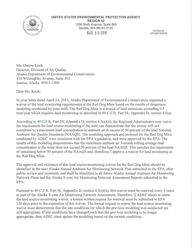
3.5.1 LEAD SOURCE ORIENTED MONITORING
To meet source-oriented lead monitoring requirements and after consultation with EPA, DEC
decided to pursue a modeling demonstration to show that lead concentrations at the ambient
boundary of the Red Dog Mine meet the new lead standard. On August 11, 2016, EPA approved
the State of Alaska’s waiver request for lead monitoring at the Red Dog Mine based on the
results of dispersion modeling. The results of the modeling showed that the maximum ambient
air 3-month rolling average lead concentration at the mine boundary did not exceed 50 percent of
the lead NAAQS. Pursuant to 40 CFR Part 58 Appendix D, section 4.5(a)(ii), this waiver must
be renewed every 5 years as part of the Alaska 5-year Air Monitoring Network Assessment. A
copy of the EPA approval letter can be found in Appendix G (Waiver G-3). DEC submitted an
updated waiver request to EPA on June 12, 2020. The waiver request included a new modeling
analysis performed by Teck Alaska Inc., the operator of the Red Dog Mine, which was reviewed
and approved by DEC. DEC is still awaiting EPA approval.
3.5.2 HARRISON CT (BUTTE) SITING
DEC requested EPA waive requirements under 40 CFR 58 Appendix E, mainly in regards to
several spruce trees that have grown up on the adjacent private property. EPA granted the waiver
on June 4th, 2019 and can be found in Appendix G (Waiver G-2).
3.5.3 ANCHORAGE MSA OZONE MONITORING
On October 15th, 2018 EPA waived the ozone monitoring requirements for the Anchorage MSA.
The population of the MSA triggered a monitoring requirement, but previous ozone
measurements in several areas of the MSA showed ozone concentrations well below 80% of the
NAAQS. The waiver approval can be found in Appendix G (Waiver G-1).
33Public Notice Draft - 2021 Monitoring Network Plan
4. NETWORK MODIFICATIONS COMPLETED IN 2021
4.1 GASEOUS ANALYZER REPLACEMENT
Most of the original NCore gaseous analyzers were purchased in 2011. The DEC received state
funding in SFY20 to replace all the gaseous analyzers over 7 years of age in the network. The
instrument swap out was delayed due to social distancing requirements caused by the COVID -
19 pandemic. Table 4-1 summarizes the instrument replacements at the NCore site that have
concluded by spring 2021.
Table 2-1: NCore Gaseous Equipment Replacements
Make Model Pollutant/purpose Serial Previous Date of new
number instrument instrument
make/model installation
Teledyne T300U CO 508 Thermo 6/4/2020
API Fisher
Scientific 48i
Teledyne T200U NOy, NOy-NO, 392 Thermo 9/8/2020
API NO Fisher
Scientific
42i-Y
Thermo 49iQ O3 1200556414 Teledyne 10/12/2020
Fisher API 400E
Scientific
Teledyne T700U Calibrator 632 Environics 1/28/2021
API 9100
Thermo 43iQ SO2 1200556415 Thermo 3/10/2021
Fisher Fisher
Scientific Scientific 43i
Additionally, the transfer standard (previous instrument was an Environics Model 6103) for the
Anchorage Garden CO site was replaced with a Teledyne Model 146iQ in May 2021.
4.2 PARTICULATE MATTER INSTRUMENT REPLACEMENT
Using State Deferred Maintenance funds, DEC will replace the Juneau particulate matter at the
Floyd Dryden Middle School site analyzers with a Teledyne T640X analyzer in 2021. The new
instrument will combine PM10 and PM2.5 measurements in one instrument. The PM2.5 Met One
BAM 1020 analyzers at the Fairbanks A-Street and Mat-Su Butte sites will be replaced with
newer model Met One BAMs, as will the PM10 BAM at the Eagle River Parkgate site.
34Public Notice Draft - 2021 Monitoring Network Plan
5. PLANNED NETWORK MODIFICATIONS FOR 2022
5.1 HARRISON CT SITE STUDY
Over the winter 2020/21, DEC conducted a saturation study in the Harrison Ct. (Butte) area to
identify a suitable substitute site location. Preliminary data analysis indicated that concentrations
are typically comparable throughout the Butte area. After meeting with EPA, two locations were
identified for further investigation, the Butte Elementary School and the Alaska Plant Materials
Center. Negotiations with the property owners have been initiated (by DEC) and plans have been
made to establish a temporary monitoring site on at least one of the two locations, and if staffing
and resources allow, both. The goal is to collect at least one year of continuous PM2.5 data
concurrently with the Harrison Ct site for long term data record comparison. After the review of
the data comparison DEC will request approval for the official site relocation in the following
Annual Network Plan if warranted.
5.2 LOW-COST SENSOR NETWORK
While the current long term monitoring network meets the regulatory requirement in terms of
number of monitoring stations and monitored pollutants, it is confined to the population centers
and does not adequately characterize conditions in outlying and rural communities.
Advances in sampling technology allowed for the development and commercial sale of smaller,
portable, and cheaper sensors. This new low-cost sensor technology provides DEC the
opportunity to expand monitoring into areas across the state that previously was cost prohibitive.
DEC is starting a pilot project to expand air quality sensor technology to a select number of hub
communities throughout the state. The intent is to broaden coverage of air quality monitoring,
and to test the new ‘low-cost sensor’ technology in Alaska’s variable and harsh climates. If the
technology proves useful, the new low-cost sensor network could be the first phase of a more
extensive statewide network.
After state funds were made available in 2019 to purchase sampling equipment for use in port
communities, DEC conducted a search for multi-pollutant sampling pods and finally purchased
eight AQmesh sensor pods. These pods are designated for use in Southeast and Southcentral
Alaska port communities. Late in 2020, DEC was able to use carry-over grant funding to
purchase ten additional sensor pods, for a total of 18 sensors. The sensor pods will collect
baseline air quality data, including particulate matter (PM), SO2, NO, NO2 and CO. The DEC
plans to set up sensor pods in 13 communities throughout Alaska. The communities selected for
a sensor pod are chosen based on location, interest, and population density. The current proposed
communities include Anchorage, Homer, Juneau, Ketchikan, Kodiak, Kotzebue, Nome, Seward,
Skagway, Soldotna, Unalaska/Dutch Harbor, and Utqiagvik.
The DEC will start installation of the AQmesh sensor pods in the communities in summer of
2021.
35You can also read