5 Drawing from Other Plans - Overview/Summary - Olmsted County
←
→
Page content transcription
If your browser does not render page correctly, please read the page content below
5 • Drawing from Other Plans

5 • Drawing from Other Plans
Overview/Summary                                             prior to a number of other on-going community, state,
                                                             and federal planning work. The following sections
One important function of a ROCOG Plan is to bring           summarize the plans that have been considered in the
together pertinent parts of previous plans and plans         preparation of this ROCOG Long Range Transportation
produced by other planning entities that contribute to a     Plan.
ROCOG Plan Update. Jurisdictions in Olmsted County that
adopt comprehensive land use plans and system level          Statewide and District Plans
transportation plans include Olmsted County, the City of     The following statewide and district plans have
Rochester and the small cities outside of Rochester. In      contributed to the formation of this ROCOG plan.
the case of Olmsted County and Rochester, the system
level transportation plan they rely on is this ROCOG Long    Minnesota GO Family of Plans
Range Transportation Plan, although the City of              Minnesota GO is a 50-year vision of the future of
Rochester also uses the transportation sections of their     transportation in the state, across all modes, adopted in
comprehensive plan. This chapter summarizes the land         2011. The plan recognizes the importance of a
use plans for Olmsted County and Rochester and               comprehensive statewide transportation system in any
contains the small city Thoroughfare and Land Use Plan       attempts to achieve maximum benefits in health,
maps, which have been prepared at the municipal level        commerce, the natural environment, and people’s overall
to guide investment in each of the seven communities         wellbeing. Where Minnesota GO lays out the vision for a
outside the Rochester area. Most of the small city plans     better future, the Family of Plans go into more detail
have been updated in the last ten years under contracts      about how to achieve that better future as it relates to
with private planning consultants.                           each of the various transportation modes.
It is also important to note that with a required update
every five years, the Plan is done after, during, and just
                                                             •   Statewide Multimodal Transportation Plan
                                                                 This plan, adopted in 2017, serves as the overall

                                                                                                                     5.1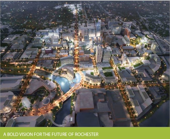
5 • Drawing from Other Plans

    guiding document for the Family of Plans, outlining           that is safe, comfortable, and convenient for all users.
    transportation priorities for the system as a whole           The plan recognizes bicycling’s important role in
    that will inform the goals of the individual mode             improving quality of life in communities throughout
    plans. In this way, the Statewide Multimodal                  the state. The plan notes that support for bicycle
    Transportation Plan ensures that the various modal            infrastructure is strongest for those facilities that
    plans that make up the Family of Plans are working            separate bicycles from auto traffic and those that
    toward common, shared goals, even while each plan             serve local and regional bicycling. The plan sets goals
    responds to the unique realities and challenges of            for safety and comfort, local bicycle network
    each mode. Where the Minnesota GO vision identifies           connections, state bicycle routes, and increased
    what the state is trying to achieve, the Statewide            ridership.
    Multimodal Transportation Plan details how the state      •   Statewide Freight System and Investment Plan
    will achieve it. The Statewide Multimodal                     This plan was adopted in 2018. Following the
    Transportation Plan establishes five goals for open           emphasis on integrated balance among various
    decision-making, transportation safety, critical              modes in the state’s freight policy, this plan
    connections, system stewardship, and healthy                  establishes goals in the areas of supporting the state’s
    communities, and identifies.                                  economy, improving mobility, preserving
•   State Aviation System Plan                                    infrastructure, safeguarding the people, and
    The State Aviation System Plan is being updated               protecting the environment and communities.
    during the preparation of this LRTP. The most recent      •   Minnesota State Highway Investment Plan
    plan is from 2012. This plan sets goals in the areas of       Adopted in 2017, this plan links the Minnesota GO
    safety; mobility and access; financial opportunity and        vision and the goals of the Statewide Multimodal
    responsibility; operations; and preservation and asset        Transportation Plan to the long-term development of
    management. The plan notes a significant gap                  the state’s highway system by identifying financially
    between the system’s capital needs and the expected           constrained investment needs. In planning for the
    funds that will be available over the 20-year span of         infrastructure projects necessary for the state’s
    the plan.                                                     highway system to meet federal and state
•   Statewide Bicycle System Plan                                 performance-based targets, the plan estimates about
    Adopted in 2016, this plan envisions a bicycle network        twice as much in project costs as will likely exist in

5.2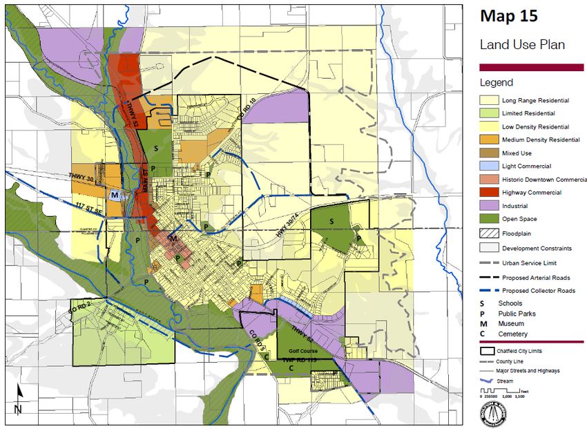
5 • Drawing from Other Plans

    funding. The plan lays out an Investment Direction,            rail system has further complications, relative to other
    which is not project-specific, but instead recommends          modes, since it has an unusual amount of private-
    categories of investment and size of investment given          sector ownership and operations responsibilities to
    the limited resources expected.                                the infrastructure.
•   Minnesota Walks and the Statewide Pedestrian               •   Greater Minnesota Transit Investment Plan
    System Plan Community Engagement Report                        This plan, adopted in 2017, follows the transit vision
    These documents together constitute the Statewide              in Minnesota GO and the transit goals of the
    Pedestrian System Plan. Last adopted in 2016, the              Statewide Multimodal Transportation Plan by
    current plan is in the process of being updated. The           identifying the financing necessary to achieve 90% of
    plan is focused on development of safe, comfortable,           the transit needs in Greater Minnesota by 2025, and
    convenient, and desirable places for people to walk or         strategizes when certain transit investments can be
    use a mobility device throughout the state. After              made with regard to available funds. The plan
    identifying various obstacles to walking, the plan sets        outlines a series of goals designed to meet the
    goals for universal access and use of pedestrian               projected growth in annual transit rides in Greater
    networks in the following categories: roadway and              Minnesota by 4.8 million by 2025.
    street design; land use and the built environment;         •   Transportation Asset Management Plan (TAMP)
    fostering creativity and partnerships; listening and           This 2019 plan updated the original 2014 plan, and
    planning; Minnesota winter and year round upkeep;              serves as a comprehensive guide to maintaining the
    and building a culture of walking.                             state’s pavements, bridges, culverts, deep stormwater
•   Statewide Rail Plan                                            tunnels, overhead sign structures, high-mast light
    Adopted in 2015, this plan addresses safety and                tower structures, noise walls, signals, lighting,
    efficiency in the state’s freight and passenger rail           pedestrian infrastructure, buildings, and intelligent
    networks as a constituent part of an integrated                transportation systems. The recommendations of the
    multimodal transportation system. The rail system is           plan were driven by the need to increase the
    particularly important to the state’s commodities              consideration of lifetime maintenance costs in capital
    industries for getting their products to market, as well       project decisions, reducing agency risk, building on
    as for the state’s manufacturing industry which is             work that has come before, and improving data
    reliant on rail for the delivery of raw materials. The         management.

                                                                                                                      5.3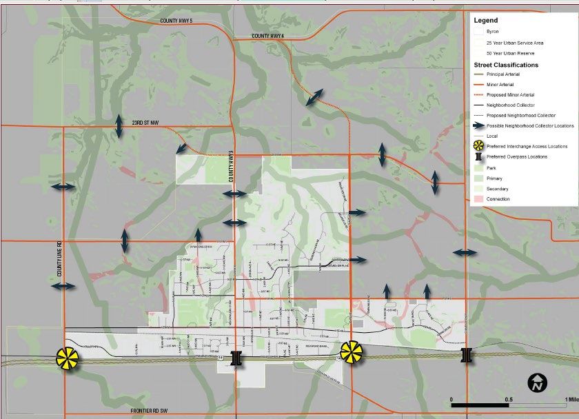
5 • Drawing from Other Plans

Other State and District Plans                                    Updated in 2018, this plan provides guidance for
                                                                  implementing ITS initiatives cost-efficiently, based on
•   District Freight Plan                                         stakeholder input concerning transportation needs. A
    This plan is scheduled to be developed between mid-           key part of the implementation of ITS initiatives is
    2020 and mid-2021.                                            sequencing them properly, since they are interrelated,
•   Strategic Highway Safety Plan                                 and thus the implementation of some of them
    This plan was adopted in early 2020 as a tool for             depends on other initiatives already being in place.
    building a highway culture in which traffic-related           The recommended initiatives further the goals of the
    deaths and injuries are no longer acceptable (the             plan:
    ultimate aim of the Toward Zero Deaths effort). The
    plan recommends actions to be taken within 1-2
                                                                     ‣   Improve the Safety of the State's
                                                                         Transportation System
    years, and other actions to be taken within 3-5 years,
    that will improve highway safety and result in fewer             ‣   Increase Operational Efficiency and Reliability
    deaths on Minnesota’s roads. These recommendations                   of the Transportation System
    revolve around issues concerning inattentive drivers,            ‣   Enhance Mobility, Convenience, and Comfort
    impaired drivers, intersections, speed, lane departure,              for Transportation System Users
    unbelted drivers and passengers, older drivers,                  ‣   Improve the Security of the Transportation
    pedestrians, younger drivers, work zones, commercial                 System; Support Regional Economic
    vehicles, and motorcyclists.                                         Productivity and Development
•   MnDOT District Safety Plan                                       ‣   Preserve the Transportation System
    A 2016 analysis of state highways in the MnDOT
    Districts in Greater Minnesota identified high-risk
                                                                     ‣   Enhance the Integration and Connectivity of
                                                                         the Transportation System
    intersections and highway segments and proposed
    some strategic investments for them that would result            ‣   Reduce Environmental Impacts
    in improved safety on rural and urban roadways in
                                                              •   MnDOT District 6 Bicycle Plan
    District 6.
                                                                  Adopted in 2019, this plan builds on MnDOT’s 2016
•   Minnesota Statewide Regional Intelligent                      Statewide Bicycle System Plan by identifying bicycle
    Transportation Systems (ITS) Architecture Plan

5.4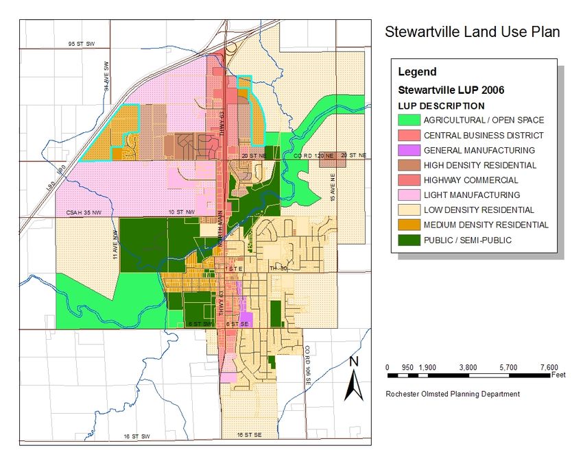
5 • Drawing from Other Plans

    infrastructure priorities in the 11-county region of       comprehensive plan in 37 years. This plan
    MnDOT’s District 6 in Southeastern Minnesota.              recommended that the City of Rochester maintain its
•   MnDOT District 6 10 Year Capital Highway                   current corporate limits as much as possible as it
    Investment Program 2019-2028                               grows, and that it encourages infill development
    This document builds on the 4-year State                   instead of expansion into undeveloped lands currently
    Transportation Improvement Program (STIP) and              outside the City. Significantly, the comprehensive plan
    ROCOG’s own 4-year Transportation Improvement              promulgates the concept of nodes and corridors:
    Program (TIP) to present a ten-year program of             concentrations of mixed residential, commercial,
    planned street and highway improvements in the 11-         retail, office, and transportation uses connected by
    county region of MnDOT’s District 6 in Southeastern        high-capacity, high-frequency transit, envisioned as
    Minnesota.                                                 bus rapid transit (BRT). This concept of nodes and
                                                               corridors adapted the ambitious plans for downtown—
•   MnDOT Complete Streets Policy
                                                               seen already in the Downtown Master Plan and the
    Effective in 2016, MnDOT must include considerations
                                                               Destination Medical Center Plan—into a scaled-up
    for modes other than automobiles in all phases of
                                                               formula that applied the ethos of density and the
    planning, project development, operation, and
                                                               primacy of transit to the rest of the city.
    maintenance. The goals of the policy are to reduce
    conflict between various modes of transportation,      •   Destination Medical Center Development Plan
    while increasing the share of trips made by walking,       On March 23, 2015, The City of Rochester adopted
    bicycling, and transit.                                    Resolution No. 133-15 authorizing the DMC Plan as
                                                               amended. This ambitious plan was prompted by
Local Transportation & Land Use                                questions about how the City of Rochester, Olmsted
Plans                                                          County, the state of Minnesota, and the Mayo Clinic
                                                               could maintain and grow the region’s position as a
The following local and regional plans have contributed        premier destination for medical care. This meant
to the formation of this ROCOG plan:                           planning a future for Rochester that focused on
•   Planning 2 Succeed: Rochester Comprehensive                patients, their companions, medical staff, and other
    Plan 2040 (P2S 2040)                                       employees in downtown Rochester. The result was a
    In 2018, Rochester adopted its first new                   DMC Plan that saw the singular importance of the
                                                               mode shift recommended in the Downtown Master

                                                                                                                 5.5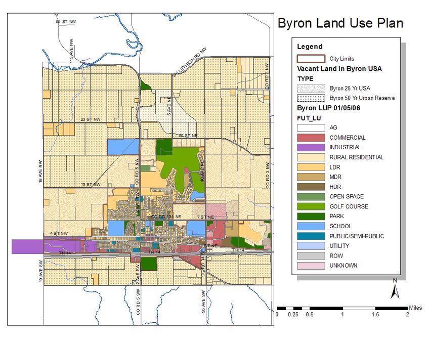
5 • Drawing from Other Plans

    Plan and recommitted to it. The DMC Plan calls for      •   Rochester Downtown Master Plan
    the daily share of commuter trips downtown by               Adopted in 2010, the Downtown Master Plan
    private car to be reduced to 43% by 2035, down from         identified the need to reduce the proportion of trips
    71% in 2015. Accomplishing this, according to the           downtown made by private cars. A key strategy
    plan, would require much more development of                identified by this plan to achieve that goal was the
    downtown residences, so that more downtown                  establishment of parking management policies and
    employees could walk to work; the development of            other travel demand management measures that
    bicycle and pedestrian infrastructure downtown; and         would provide commuters with alternatives to driving
    the establishment of a Downtown Circulator—a high-          and parking a car downtown. This plan set a goal of
    capacity, high-frequency transit mode that would            reducing the proportion of trips to downtown made
    move people from large parking reservoirs into              by private car to 50% by 2030. Subsequent plans
    downtown. This plan will be updated in 2020.                (especially the DMC Plan and P2S 2040) have
•   Destination Medical Center: Integrated Transit              recognized the importance of this goal and have
    Studies                                                     made it even more aggressive.
    In 2018, the City of Rochester finished a set of four   •   Rochester Transit Development Plan
    interdependent plans that explored the details              This 5-year plan was adopted by the City of Rochester
    necessary to realize the vision of the 2015 DMC Plan.       in 2017 to guide the expansion and growth of
    These plans focused on the City Loop active                 Rochester Public Transit (RPT), with the needs of the
    transportation features; Street Use, Street                 DMC project and the infill/density recommendations
    Operations, and Complete Streets; Parking and               of Planning 2 Succeed informing the transit system’s
    Transportation Management Authority; and the                development. This plan focuses on how RPT’s system
    Transit Circulator (now known as Downtown Rapid             could be more useful to more riders. Some of the key
    Transit). These plans were guided by the overarching        recommendations would expand off-peak service,
    principle of the DMC Plan, that downtown Rochester          allowing more riders to utilize RPT’s service outside of
    could only be successful with infrastructure that           the traditional heavy-use morning and afternoon peak
    supported greater density along the Rapid Transit           hours.
    route and a lower proportion of trips made by private
    cars.
                                                            •   Rochester Area Bicycle Master Plan
                                                                This plan was adopted by the City of Rochester in

5.6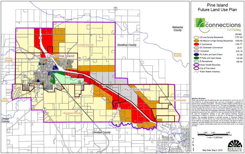
5 • Drawing from Other Plans

    2012 and identifies needed bicycling infrastructure      •   TH 14 West / Byron Area Corridor Analysis
    that will improve system connectivity and increase the       This analysis is underway during the preparation of
    usability of the bicycle and pedestrian network for          the LRTP. This examination of US-14 between the
    both recreation and transportation. An update to this        Cities of Rochester and Byron will result in
    plan is expected by the end of 2020.                         recommendations about upgrades to interchanges
•   Downtown Circulator TOD Study                                and traffic capacity in this important and growing
    This study is underway during the preparation of the         commuter corridor.
    LRTP. As an outgrowth of the DMC Plan and the            •   CR 104 Corridor Plan
    Integrated Transit Studies, the TOD study will               This study, completed in 2006, recommended County
    examine the proper siting and design of transit              Road 104/60 Ave NW in Rochester as a major arterial
    stations along the Downtown Circulator (now known            corridor that would form part of a beltway around the
    as Downtown Rapid Transit) route, with emphasis on           outer edge of the Rochester urban area.
    placemaking and economic development, along with
    optimized transit operations.
                                                             •   TH 63 South Corridor Plan
                                                                 This 2010 study was part of a larger study of
•   Downtown Transit Circulator Small Starts                     improvements to access to Rochester International
    Grant Development                                            Airport. This study considered the implications of
    This study is underway during the preparation of the         changes to roadways of various classifications that
    LRTP. As an outgrowth of the DMC Plan and the                intersect US-63 between Rochester and Stewartville.
    Integrated Transit Studies, the Circulator project
    development will recommend the mode choice and
                                                             •   Rochester Parks and Recreation System Plan
                                                                 This 2016 plan takes a comprehensive look at the
    route alignment for the downtown Circulator (now
                                                                 needs of the City of Rochester parks, natural areas,
    known as Downtown Rapid Transit). The process thus
                                                                 and trails. Trails are identified as crucial in making the
    far has resulted in a locally preferred alternative of
                                                                 parks and recreation system accessible by the most
    bus rapid transit on a route from the western park-
                                                                 people possible. The plan also characterizes trails as
    and-ride terminus along 2 St SW, and then south
                                                                 an important transportation option for public health
    along Broadway Ave. to the southeastern park-and-
                                                                 and sustainable transportation.
    ride terminus at Graham Park/Seneca site.
                                                             •   North Rochester Transportation Study
                                                                 This study, undertaken in 2011-2012, examined the

                                                                                                                      5.7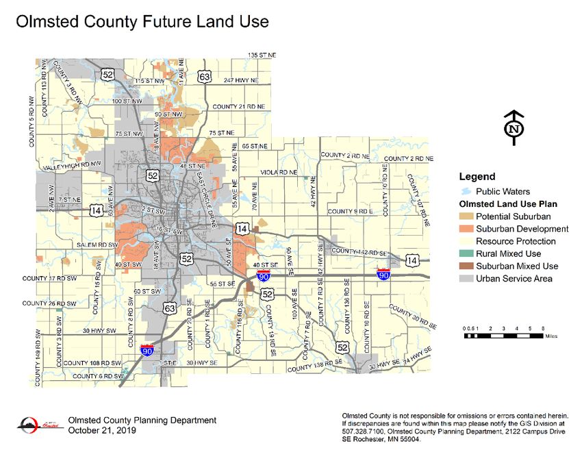
5 • Drawing from Other Plans

    transportation needs in far northwest Rochester,         •   Rochester Complete Streets Policy
    following up on a similar study conducted in 2005-           Adopted in 2009, this policy explicitly recognizes the
    2006. Though the study was not formally completed            needs of pedestrians, cyclists, and transit riders, and
    due to budget constraints, it did result in some             states that they must be considered at the beginning
    recommended projects for improving access to US-52           of planning for new and reconstructed developments
    at 55 St NW and 65 St NW.                                    and street projects. The goal of the policy is to
•   Broadway Corridor Study                                      balance the long-dominant needs of motorists and
    This 2015 study proposed systematic improvements             freight handlers with other, traditionally unconsidered
    to the length of Broadway Ave. from 37 St NE to the          users of the road, and to make non-motorized travel
    interchange with US-52 in the City of Rochester. The         in Rochester safer and more attractive.
    study broke Broadway into seven zones: three north       •   Mayo Medical Center Master Plan
    of downtown, and four south of downtown                      Last adopted in 2016, this plan is updated every five
    (downtown was not included in this study, as it was          years. The plan itemizes the capacities of properties
    within the DMC boundary and was being well studied           across the Mayo Clinic’s varied properties throughout
    by the DMC Plan at the time). By applying complete           Rochester, providing this LRTP with valuable
    streets guidelines to the designs and                        information on parking lot and Mayo patient and
    recommendations, this study envisions a cohesive             employee shuttle ridership.
    design for multiple transportation modes along the
    length of the City of Rochester’s main north-south
                                                             •   Airport Master Plan
                                                                 The Management Company of Rochester International
    roadway.
                                                                 Airport completed its most recent update of the AMP
•   Rochester 2nd St SW Corridor Plan                            in 2009. ROCOG and MnDOT District 6 initiated a
    This 2009 plan examined the expected growth along            Subarea Transportation Plan and Corridor
    2 St SW, between Rochester’s essential institutions,         Preservation Study to address the need for improved
    the Mayo Clinic downtown and St Marys Hospital. The          access to Trunk Highway 63 and the upgrading or
    plan’s vision for this corridor is a place designed at       realignment of perimeter roads serving the airport. A
    human scale, where pedestrian, bicycle, and transit          new Airport Master Plan is underway and is
    modes are elevated in priority compared to today,            anticipated to be completed by the third quarter of
    and where automobile traffic is moderated.                   2020. Once all the work is done and the Master Plan

5.8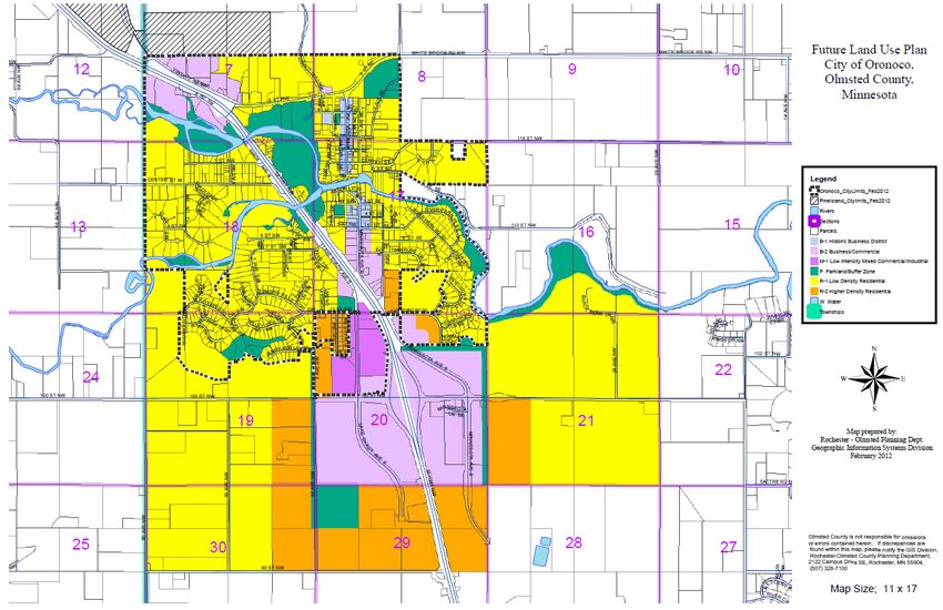
5 • Drawing from Other Plans

    and Airport Layout Plan are submitted to the FAA, the         program emphasizes enforcement, engineering,
    Master Plan will be adopted by the City of Rochester          education, and emergency medical and trauma
    (with input from the Airport Company Board and the            services.
    Airport Commission) and the Airport Layout Plan           •   DNR State Trail Planning: Stagecoach Trail and
    approved by the FAA. There will be one more                   Whitewater Country Trail
    opportunity for public input, tentatively planned for         The Stagecoach Trail Master Plan of 2012
    late June of 2020.                                            recommends linking several state trails in and west of
•   Regional Transportation Coordinating Council                  Rochester, to be used by pedestrians, bicyclists,
    Plan                                                          skaters, cross-country skiers, horseback riders, and
    MnDOT completed the 2017 Regional Transit                     snowmobilers on various segments along the trail.
    Coordination Plan for Southeast Minnesota, focusing           The Whitewater Country Loop State Trail Master Plan
    on how to streamline dispatching, share data, and             of 2008 recommends a similar connection between
    improve communication among various transportation            trails in Rochester and points farther east.
    providers in the 11-county region.                        •   Olmsted County Land Use Plan
•   Olmsted County ADA Transition Plan                            This 2014 plan addresses the land use projections for
    Adopted in 2018, this plan details the ways in which          the coming decades, focusing on how to limit urban
    Olmsted County Public Works plans to make all public          sprawl and thus maintain effective and efficient utility
    rights of way accessible to all users, regardless of          and transportation systems.
    disability.                                               •   Journey to Growth
•   County Highway Safety Plan                                    This effort, begun in 2014, was organized around the
    This 2009 plan was conducted as part of a                     goal of diversifying the regional economy by
    comprehensive effort to identify safety priorities that       promoting entrepreneurship and business
    will contribute to a reduction in serious injuries and        development in areas such as manufacturing,
    deaths in crashes on County roads.                            agriculture, and technology.
•   SE Minnesota Towards Zero Deaths Program                  •   Olmsted County Capital Improvement Plan
    Begun in 2005, this partnership of 11 counties has            Included in the 2019-2023 Capital Improvement Plan
    worked toward reducing traffic fatalities and serious         (CIP) is a twenty-year forecast of transportation
    injuries by changing the culture of driving. The              projects that will be needed in Olmsted County. While

                                                                                                                     5.9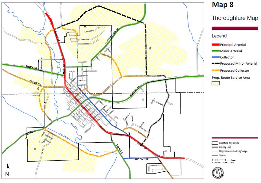
5 • Drawing from Other Plans

   costs are estimated for these projects, sources of   ROCOG Area Future Land Use Plans
   funding are not yet identified.
                                                        The Olmsted County and Rochester Land Use Plans
                                                        recognize a 50-year Rochester Urban Service Area
                                                        (RUSA) for planning purposes. Within the RUSA boundary
Figure 5-1: Olmsted County Future Land Use Map

5.10
5 • Drawing from Other Plans
the City has adopted a Future Land Use Plan as a guide Rochester. These plans provide high-level visionary
to community development by providing a consistent set guidance to future land use and public space
of policies applied to general geographic areas to guide development in the downtown area of Rochester as well
future land use decisions. The primary purpose of the as to needed downtown mobility improvements.
Land Use Plan is to inform the review and approval of
proposals affecting land use and land development and Figure 5-2: Example of Graphic Guidance from
assist in planning for future capital improvement needs. 2015 Destination Medical Center Master Plan
In relation to development of the transportation plan, the
land use plan assists in identifying the intensity and
character of travel demand, the types of design or
program features to be considered in different areas of
the community, and the timing of future improvement.
Rochester Downtown Master Plan and
DMC Development Plan
To assist in applying the principles of the Land Use Plan
and refine future plans for development, periodically the
City of Rochester or other public agencies will complete
major subarea or corridor plans, and private sector
developers will prepare master General Development
Plans for smaller areas as a first step in the city
development approval process. In the last decade, two It is expected that employment downtown will
major efforts looking at future downtown development approximately double in the next generation to over
have been undertaken: (1) the Rochester Downtown 60,000 jobs in the DMC district. In addition, downtown
Master Plan, a joint effort of the City of Rochester, the housing is expected to grow from approximately 1,000
Rochester Chamber of Commerce, the Rochester units currently to as many as 3,500 units over the
Economic Development Authority and the University of planning horizon, and the University of Minnesota-
Minnesota-Rochester; and (2) the Destination Medical Rochester will develop a new campus at the south end of
Center Development Plan, led by the Destination Medical downtown with capacity for 5,000 students, well above
Center Corporation in cooperation with the City of the current level of 500 students they are serving in
5.115 • Drawing from Other Plans
rented space in a downtown mall adjacent to the Mayo primarily state and county highways and transit and
Medical Center. active transportation facilities and services that serve
regional travel.
Small City Land Use and Thoroughfare
Plans • Byron: The plan for Byron is adopted as part of
Byron’s comprehensive plan and was last updated in
Most of the small cities in Olmsted County have prepared
2010 (Figures 5-3 & 5-4).
and adopted major street plans, which are illustrated in
this section. In instances where a city has not prepared a • Chatfield: The land use plan for Chatfield was
transportation system plan, an illustrative Major Street adopted as part of a Comprehensive Plan update
Plan has been developed by ROCOG for the purpose of completed in 2015 (Figures 5-5 & 5-6).
identifying a local major street network consistent with • Dover: The plan for Dover is an illustrative plan
ROCOG’s System Development Guidelines and access reflecting current municipal limits and known
management principles, taking into consideration the development plans. Plan was shown as illustrative in
land use plans for the community. It is recommended the ROCOG 2040 Plan (Figures 5-7 & 5-8).
that those communities without an adopted or • Eyota: The Land Use plan for Eyota was formally
recognized plan utilize the illustrative plans included adopted in 2008 but had been used as a guide for a
herein as a starting point and eventually develop a major number of years prior to that (Figures 5-9 & 5-10).
street plan. Beginning on the next page are graphics
• Oronoco: In 2012, the Rochester-Olmsted Planning
illustrating the most recent land use and transportation
Department prepared a future land use map for
plans that have been prepared and adopted by small
Oronoco (Figures 5-11 & 5-12).
municipalities in Olmsted County. The following
paragraphs highlight the vintage of each plan and other • Pine Island: The city of Pine Island completed a
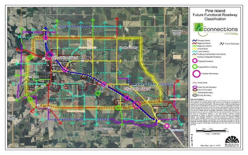
notes relative to its status. Comprehensive Plan update in 2010 (Figures 5-13 &
5-14).
ROCOG is focused on planning for regional travel
patterns, and small city land use and thoroughfare plans
• Stewartville: The city of Stewartville adopted an
updated land use plan as part of a Comprehensive
informed the planning of facilities and services serving
Plan updated completed in 2009 (Figures 5-15 & 5-
regional travel needs and the identification of projects
16).
associated with these regional networks, which are
5.125 • Drawing from Other Plans
Figure 5-3: Byron Area Thoroughfare Plan Figure 5-5: Chatfield Land Use Plan
Figure 5-4: Byron Land Use Plan
Figure 5-6: Chatfield Area Thoroughfare Plan
5.135 • Drawing from Other Plans
Figure 5-7: Illustrative Dover Area Figure 5-8: Dover Land Use Study
Thoroughfare Plan
Dover Long Range Thoroughfare Plan (Preliminary)
(Developed by staff as part of 2035 Plan)
N
DM&E
Rai lroad
-,1 4
%
$
142
/.1 0
LEGEND
Street Classifications
ARTERIAL DM&E Rail Corridor
COLLECTOR
EXPRESSWAY Boundary of Olmsted Co.
FARTERIAL
FCOLLECTOR Dover City Limits
FREEWAY
5.145 • Drawing from Other Plans
Figure 5-9: Eyota Land Use Plan Figure 5-11: Oronoco Land Use Study
Figure 5-10: Eyota Area Thoroughfare Plan Figure 5-12: Illustrative Oronoco Area
Thoroughfare Plan
5.155 • Drawing from Other Plans Figure 5-13: Pine Island Area Thoroughfare Figure 5-15: Stewartville Area Thoroughfare Plan Plan Figure 5-14: Pine Island Land Use Plan 5.16
5 • Drawing from Other Plans

Figure 5-16: Stewartville Land Use Plan

                                                               5.17
5 • Drawing from Other Plans 5.18
You can also read