A Decentralized Fuzzy Rule Based Approach for Computing Topological Relations between Spatial Dynamic Continuous Phenomena with Vague Boundaries ...
←
→
Page content transcription
If your browser does not render page correctly, please read the page content below
Article

A Decentralized Fuzzy Rule‐Based Approach for Computing
Topological Relations between Spatial Dynamic Continuous
Phenomena with Vague Boundaries Using Sensor Data
Roger Cesarié Ntankouo Njila 1,*, Mir Abolfazl Mostafavi 1,* and Jean Brodeur 2

 1 Centre de Recherche en Données et Intelligence Géospatiales (CRDIG),
 0611 Pavillon Casault Université Laval, Québec City, QC G1K 7P4, Canada
 2 GéoSémantic Research, Sherbrooke, QC J1L 1W8, Canada; recherchegeosemantic@videotron.ca

 * Correspondence: roger‐cesarie.ntankouo‐njila.1@ulaval.ca (R.C.N.N.);
 mir‐abolfazl.mostafavi@scg.ulaval.ca (M.A.M.)

 Abstract: Sensor networks (SN) are increasingly used for the observation and monitoring of spatio‐
 temporal phenomena and their dynamics such as pollution, noise and forest fires. In multisensory
 systems, a sensor node may be equipped with different sensing units to observe and detect several
 spatiotemporal phenomena at the same time. Simultaneous detection of different phenomena can
 be used to infer their spatial interactions over space and time. For this purpose, decentralized spatial
 computing approaches have shown their potential for effective reasoning on spatial phenomena
Citation: Ntankouo Njila, R.C.;
 within a sensor network. However, in most cases, spatial extents of continuous dynamic phenom‐
Mostafavi, M.A.; Brodeur, J. A
Decentralized Fuzzy Rule‐Based
 ena are uncertain, and their relations and interactions cannot be inferred by the existing approaches
Approach for Computing at the sensor node level. To address this limitation, in this paper, we propose and develop a decen‐
Topological Relations between tralized fuzzy rule‐based spatial reasoning approach to depict the spatial relations that hold be‐
Spatial Dynamic Continuous tween two evolving spatial phenomena with fuzzy boundaries. The proposed method benefits from
Phenomena with Vague Boundaries a more adapted fuzzy‐crisp representation of dynamic phenomena observed by SN where each
Using Sensor Data. vague phenomenon is composed of five distinguished zones including the kernel, conjecture and
Sensors 2021, 21, 6840. exterior zone and their boundaries. For each detected phenomenon, a sensor node will report one
https://doi.org/10.3390/s21206840 of these zones based on its location. Aggregation of the information reported from the sensor nodes
 allows reasoning on spatial relations between the observed phenomena and their evolution. Such
Academic Editors: Jacopo Aguzzi,
 spatial information provides users with more valuable near real‐time information on the state of
Corrado Costa, Sergio Stefanni,
 different phenomena that can be used for informed decision‐making.
Luca Mirimin, Valerio Funari and
Marcello Calisti
 Keywords: sensor networks; decentralized spatial reasoning; fuzzy spatial relations; dynamic
Received: 1 August 2021
 phenomena; fuzzy‐crisp objects
Accepted: 12 October 2021
Published: 14 October 2021

Publisher’s Note: MDPI stays neu‐ 1. Introduction
tral with regard to jurisdictional In recent decades, sensors have been continuously improved and have become
claims in published maps and institu‐
 smaller, cheaper and more intelligent [1]. These technologies are increasingly used for
tional affiliations.
 many applications, such as in military, healthcare, area surveillance, environmental mon‐
 itoring, security, etc. [2]. Sensors help in remotely measuring the physical properties of
 phenomena of interest in order to detect their presence at a given location and time [3];
 they allow users to derive and maintain an accurate and up‐to‐date digital picture of con‐
Copyright: © 2021 by the authors. Li‐
 tinuously changing real‐world phenomena which may be either discrete (e.g., people
censee MDPI, Basel, Switzerland.
This article is an open access article
 movement) or continuous (e.g., temperature, humidity). In particular, spatiotemporal
distributed under the terms and con‐
 continuous phenomena monitored by sensor networks are inherently fuzzy and uncertain
ditions of the Creative Commons At‐ [4], and hence their spatial shape is ultimately vague. Fuzzy‐crisp spatial objects pro‐
tribution (CC BY) license (http://crea‐ moted in [5] represent and model vague‐shape phenomena. In this model, the geometry
tivecommons.org/licenses/by/4.0/).

Sensors 2021, 21, 6840. https://doi.org/10.3390/s21206840 www.mdpi.com/journal/sensors
Sensors 2021, 21, 6840 2 of 26

 of an object is composed of a kernel and a conjecture part. The kernel part definitely be‐
 longs to the vague object but one cannot say with certainty whether the conjecture part,
 which is considered as the broad boundary, belongs to the vague object. Understanding
 the complexities of the detection, monitoring and representation of such vague spatial
 phenomena and their dynamics and their interactions with other similar objects using
 sensor networks is a very challenging task.
 Among these complexities, the detection and monitoring of the evolving relations
 and interactions between vague‐shaped dynamic phenomena is very important for in‐
 formed decision‐making. Hence, topological relations are the predominant backbone of
 qualitative spatial reasoning focusing mostly on objects that are embedded in R2 [6]. To‐
 pology is the study of the relative positioning of two geometric objects [7]. The division of
 the internal structure and external part of geographical entities is the premise of the anal‐
 ysis of topological relations. Currently, most of the existing geographic information sys‐
 tems for representing spatial relations are developed for crisp objects [8], which are less
 adapted for the representation and analysis of real‐world situations about many environ‐
 mental phenomena with fuzzy boundaries. In contrast with such tools, sensor observa‐
 tions break the internal and external divisions of the spatial extent of a vague phenomenon
 into more fine spatial units, adding therefore a second level of vagueness in sensor obser‐
 vations. Analyzing spatial relationships that hold between monitored phenomena from
 sensor measurements therefore becomes more challenging. For instance, using sensor
 data observed for two vague‐shaped phenomena A and B, we need to express relations
 such as the phenomenon A is nearly overlapping phenomenon B if the kernel part of A
 overlaps the conjecture part of B or the conjecture part of A overlaps the conjecture part
 of B or the kernel part of B overlaps the conjecture part of A; such information would be
 important for spatial decision support systems (SDSS).
 Formal representation of spatial relations between objects is an important part of the‐
 ories of spatial data [9]. Many computing models have been developed for spatial model‐
 ing and reasoning about geospatial phenomena and spatial relations. The most important
 examples of these models include the 4‐intersection model (4IM) [10], 9‐intersection
 model (9IM) [11], Region Connection Calculus (RCC) [12], or calculus‐based model (CBM)
 [13]. RCC sets of relations such as RCC5 and RCC8 were originally developed for ideal
 regions, not subject to imperfections such as vagueness or fuzziness which are found in
 many applications requiring geographic analysis [14]. The RCC model has been popularly
 adopted by qualitative spatial reasoning, but it lacks formal description and the relations
 are hard to calculate [15]; RCC is therefore difficult to extend and use to represent topo‐
 logical relations among fuzzy regions. On the other hand, considering the vague nature
 of fuzzy regions and related complexities involving their spatial relations, Li and Li [14]
 found RCC5 or RCC8 corresponding composition tables too arduous and error‐prone.
 Such reasoning becomes even more complex considering the necessity of on ‐the‐fly rea‐
 soning on multi‐sensor data obtained from continuously evolving vague‐shaped phenom‐
 ena.
 When equipped with different sensing devices, sensor networks allow multiple cal‐
 culations and combination of stimuli about more than one phenomenon, as presented in
 SSN ontology [16]. Simultaneous detection of two phenomena in a sensor node (A and B)
 reveal the intersection of A and B in that node, while their local disjunction may be re‐
 vealed by the single detection of A or B. In such a partitioned topological space, the Inter‐
 section Model (IM) as an integrated model [17] seems appropriate for the description of
 the relations between A and B. However, because sensor observation offers a high level
 of granularity in describing a scene, particularly about spatial relations among fuzzy‐crisp
 regions with broad boundaries, the 4IM and 9IM presented in [10,11] cannot describe the
 spatial relations that hold between such regions.
 In contrast to 4IM and 9IM models, the , which is an extension of the 9IM
 model, presents an interesting alternative solution for the representation and analysis of
 the spatial relations between vague‐shaped spatial objects. This model is presented by a
Sensors 2021, 21, 6840 3 of 26

 5X5 matrix in which each of the 25 distinct elements can represent, on a Boolean base, a
 specific intersection between two fuzzy‐crisp objects, each composed of five distinct parts
 [18]. Then, the 5X5 Intersection Model can be built based on the intersection be‐
 tween the parts of two vague‐shaped phenomena inferred over the sensor network to de‐
 scribe the spatial relation that holds between them.
 Hence, in this paper, we propose and develop a novel decentralized fuzzy rule‐based
 spatial reasoning approach based on the ( ) to depict the spatial relations that hold
 between two phenomena with fuzzy boundaries monitored by a sensor network. In this
 approach, sensor data are used to describe five distinct states for each sensor with respect
 to each spatially evolving continuous phenomenon with fuzzy boundaries. The structure
 and values in are used to describe and depict spatial relations that hold between
 monitored phenomena at a given time with the aim of better supporting the spatial deci‐
 sion‐making process. In this approach, partial and local spatial relations between moni‐
 tored phenomena are deducted from sensor observations of individual sensor nodes and
 their collaboration with linked neighboring nodes, while the spatial relations as a whole
 and their changes are inferred overall to the SN extent. The proposed approach is then
 applied to a case study and its advantages and limitations are discussed.
 The remainder of this paper is organized as follows. Section 2 revises some key con‐
 cepts on spatial reasoning and computing models for topological relations, with special
 attention paid to the models describing spatial relations between objects with vague‐
 shaped and ill‐defined boundaries. Section 3 presents the framework of the proposed ap‐
 proach in computing qualitative spatial information depicting fuzzy relations that hold
 between phenomena with fuzzy boundaries monitored by sensor networks. This ap‐
 proach is then formally described for its implementation, the results of which are pre‐
 sented in Section 4 while testing its applicability over the 44 scenes of fuzzy spatial rela‐
 tions. Section 5 draws conclusions and identifies future research works.

 2. Background on Spatial Reasoning and Computing Models for Topological Rela‐
 tions
 Spatial relations between objects are defined based on their relative positions. These
 relations are widely used by the query languages for spatial data retrieval and analysis in
 geographic information systems (GIS) [19]. Spatial relations are commonly grouped into
 topological relations, direction relations and metric relations [20,21]. Topological relations
 are the predominant backbone of qualitative spatial reasoning, focusing mostly on objects
 that are embedded in R2 [6] and more recently on three‐dimensional space. Topology is
 the study of the relative position of two geometric objects [7] at a given time. The division
 of the internal and external spaces of geographical entities is the premise of the analysis
 of topological relations; currently, most division methods are crisp [8], which does not
 conform to the real‐world situations where many environmental phenomena have fuzzy
 boundaries (e.g., air pollution, heat islands, magnetic fields, storm intensity) [22].
 Spatial modeling and reasoning about real‐world phenomena from sensor data has
 received a lot of attention in recent years [23]. Many computing models have been devel‐
 oped for spatial modeling and reasoning about geospatial phenomena and spatial rela‐
 tions, among which the calculus‐based model (CBM) [13,18], the Intersection Model (IM)
 is the most popular formal and extensible model with different versions. However, many
 challenges regarding modeling and analysis of the large‐scale phenomena with ill‐defined
 boundaries from sensor data still persist. The fuzzy‐crisp region model proposed by Paul
 and Schneider [5] and adopted in [24] is an example of model for more realistic represen‐
 tation of fuzzy phenomena. This model, which is, to some extent, similar to the α‐cuts
 model [25], is composed of kernel and conjecture parts. The kernel part definitely belongs
 to the vague object. However, one cannot say whether the conjecture part, which is con‐
 sidered as the broad boundary of the vague object, belongs to it with certainty.
Sensors 2021, 21, 6840 4 of 26

 2.1. The Region Connection Calculus (RCC)
 Because topological relations constitute an important facet of how humans perceive
 spatial configurations, a large proportion of the spatial information conveyed in natural
 language discourse is related to topology. For instance, one may like to find out, if two
 regions are adjacent, if one is contained within the other or if they overlap. The Region
 Connection Calculus (RCC) method has been proposed as a means to model such topo‐
 logical relations [12]. Reference [26] suggests that it is possible to effectively compute spa‐
 tial relations with a quite expressive set of spatial relations using the RCC model. This
 allows building a wide range of decision procedures based on inferred topological rela‐
 tions. RCC is a qualitative spatial representation based on a simple primitive relation of
 connection between regions. Relationships are defined by means of connection relation
 , which holds between phenomenon A and B when A and B share a common point.
 In sensor networks, if A and B are jointly sensed by the same sensor node, this means A
 and B are present at this particular point and may have several possible relations.
 Two versions of RCC exist; the RCC‐5 and RCC‐8 schemes consist of five and eight
 basic topological relations, respectively. The two sets of topological relations (RCC‐5 and
 RCC‐8) were compared by Baode and Qi [15], as shown in Figure 1. In RCC‐5 the influence
 of boundaries is ignored [15], leading to the five spatial relationships: DC(A,B) for A and
 B are disconnected; PO(A,B) for A and B partially overlap; PP(A,B) and PPI(A,B) for A is
 a proper part and inverse proper part of B, EQ(A,B) for A is equal to B, whilst considering
 the effect of boundaries as is the case in RCC‐8, three other relations are considered:
 EC(A’B) for A is externally connected to B, TPP (A,B) and TPPI(A,B) for A is a tangential
 proper part or inverse tangential proper part of B.

 RCC8
 TPPI (A, B) NTPPI (A, B)
 DC (A, B) EC (A, B) PO (A, B) TPP (A, B) NTPP (A, B) EQ (A, B)

 A A A B B
 A B B A A
 B B
 B A B A

 DC(A, B) EQ (A, B)
 RCC5 PO (A, B) PP (A, B) PPI (A, B)

 Figure 1. Illustration of RCC5 and RCC8 set of topological relations.

 RCC sets of relations, such as RCC5 and RCC8, were originally developed for crisp
 regions, not subject to imperfections such as vagueness or fuzziness which are found in
 many applications requiring geographic analysis [14]. The RCC model has been popularly
 adopted by qualitative spatial reasoning, but it lacks formal description and is hard to
 calculate [15]; it is therefore difficult to extend RCC and apply it to compute topological
 relations among fuzzy regions in sensor networks characterized by limited distributed
 computing resources. Binary complements are helpful but still sound reductive [27]. The
 use of a single connection primitive ( , ) for reasoning about spatial relationships, as
 in the case in basic RCC, requires further fuzzy reasoning rules to infer spatial relations
 that hold between monitored phenomena with vague spatial shape [28] information on
 broad boundaries in reasoning about topological relations between regions, which may
 be useful for SDSS, as shown in RCC‐8 for simple crisp regions.

 2.2. The Intersection Model (IM)
 Based on point‐set topology, the first IM was formerly presented in [10], based on
 which many other IM versions have been developed over time. The followings are the
 most prominent IM:
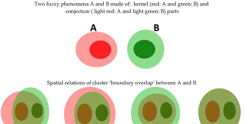
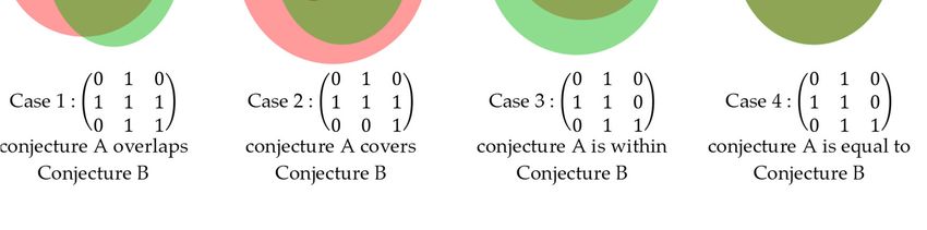
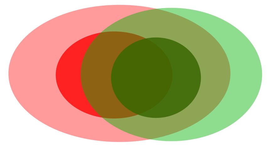
Sensors 2021, 21, 6840 5 of 26 the 4‐intersection model (4IM), which has been extended to cope with various spatial considerations into many IM releases[10], the 6‐intersection model 6‐IM [15], the 9‐intersection model (9IM) [11], fuzzy 9‐Intersection Model (F9‐IM) [29], the 16‐intersection model (16‐IM) [18,30], the 25‐intersection model (25‐IM) [20,31]. In 4‐IM, spatial objects are divided into boundary and interior and describes the top‐ ological relations between two spatial objects using a quaternion matrix, represented as follows: ∩ ∩ 4 (1) ∩ ∩ where and denote the interior and boundary of the object , and and de‐ note the interior and boundary of , respectively. The intersection between two crisp sets may be either non‐empty (1) or empty (0), so a 4‐intersection model can describe 16 topo‐ logical relations, among which only 8 topological relations between two crisp regions are significant [29]. These eight topological relationships are: disjoint, meet, overlap, contain, cover, coveredBy, containedBy and equal. These relations correspond to RCC‐8 relations: DC, EC, PO, NTPP, TPP, TPPi, NTPPi, EQ, respectively [32]. The 4IM has a limited ability to distinguish topological relations because it is easy to confuse relations (for example between line/line relations and line/region) [31]. Furthermore, there is no consideration about the eventual broad nature of boundaries. The 9IM was proposed in [11], where the exterior of objects is considered in addition to their interior and border compared to 4IM. An R9IM for modeling topological relations between simple crisp regions can be represented as follows: ∩ ∩ ∩ 9 ∩ ∩ ∩ (2) ∩ ∩ ∩ where, , and represent the interior, boundary and the exterior of the object , and , and represent the interior, boundary and the exterior of the object , re‐ spectively. Considering the interior, boundary and the exterior of objects gives place to 512 (2 ) possible topological relations. However, most of the topological relations deter‐ mined by the 9‐intersection model make no sense if the physical reality of 2D space is considered [29]. Clementini and Di Felice [33] have considered the broad nature of a region boundary and modeled 44 cases of significant spatial relationships that hold between two regions with broad boundaries. In their approach, they build a conceptual‐neighborhood graph for regions with a broad boundary. Then, the 44 significant cases of topological relations are clustered in 14 groups of qualitative spatial relations [33] using a topological distance concept. Topology distance is a major argument used in building clusters and analyzing topology consistency in the defined spatial relation [34]. For instance, let us consider the cluster of spatial relations named “boundary overlap” in [33] as shown in Figure 2. In this cluster, we have four relations defined between objects A and B (boundary of A overlaps that of B (case 14); boundary of A contains that of B (case 15); boundary of A is within that of B (case 16); boundary of A is equal to that of B (case 17)). As we can see, the differences in these relations between boundary of A and that of B are ignored in the cluster level even though these differences may be of major importance for SDSS.
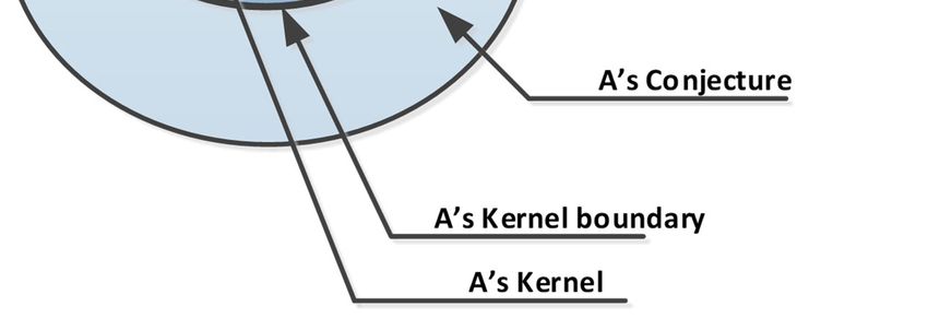
Sensors 2021, 21, 6840 6 of 26

 Figure 2. Cluster “boundary overlap” of spatial relations between regions with broad boundaries (conjecture part) mod‐
 eled using the 9IM with poor specification on topological relations.

 A vague‐shaped region considered in the 44 topological relationships presented in
 [33] is based on the egg‐yolk model of fuzzy regions [35]. Tang et al. [18] have considered
 spatial regions with broad boundaries with settings in which the yolk (kernel) part may
 be out of the white (conjecture) and have shown possible settings of a simple fuzzy region.
 Based on this consideration, the 9IM seems irrelevant to model spatial relationships be‐
 tween such vague‐shaped regions, and Tang et al. [18] suggested the use of a 4X4IM
 (16IM) for modeling 152 cases of realizable spatial relations, but qualitative specifications
 about these relations require supplementary analysis over the resulting 4X4IM. It is in the
 same order that the Dimensionally Extended 9IM is developed as an appropriate model
 for analyzing topological relationships between complex regions with broad boundaries
 [36]. The dimensional extended 9‐intersection model (DE‐9IM) extended the 9IM by con‐
 sidering the dimensions of inferred intersections; DE‐9IM can distinguish more detailed
 topological relations compared to the 9IM [21].
 It is important to mention that applying such a model for reasoning on spatial rela‐
 tions of vague‐shaped objects from sensor data is more challenging. This is because it is
 difficult to effectively extract the spatial extent of the vague shaped phenomena from sen‐
 sor observations due to their limited sensing ranges. This limits the effective computation
 of the dimension of the intersection among poorly identified parts of observed phenom‐
 ena.

 3. Computing and Modeling Fuzzy Spatial Relations Using in SNs
 As mentioned earlier, we consider that the fuzzy‐crisp region model is more appro‐
 priate for realistic reasoning about environmental phenomena with vague or fuzzy
 boundaries. According to this model, a simple fuzzy‐crisp region is composed of its kernel
 and conjuncture regions and can be expressed using five distinguished topological parts
 [18], as presented in Figure 3.
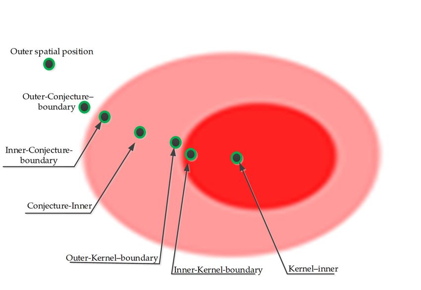
Sensors 2021, 21, 6840 7 of 26

 Figure 3. Topological parts of a simple fuzzy‐crisp region.

 Let us consider two fuzzy‐crisp regions A and B. Let us also consider
 , , , and to be the kernel, boundary of the kernel, conjecture, boundary of
 the conjecture and exterior of A, respectively, and , , , and to be the ker‐
 nel, boundary of the kernel, conjecture, boundary of the conjecture and exterior of B, re‐
 spectively. The relations between A and B can be built using the 25‐Intersection model
 model as follows:
 ∩ ∩ ∩ ∩ ∩
 ⎡ ⎤
 ⎢ ∩ ∩ ∩ ∩ ∩ ⎥
 , ⎢ ∩ ∩ ∩ ∩ ∩ ⎥ (3)
 ⎢ ∩ ∩ ∩ ∩ ∩ ⎥
 ⎣ ∩ ∩ ∩ ∩ ∩ ⎦
 This was presented in [18] and implemented in modeling cases of spatial re‐
 lations between 3D spatial objects [31] and between fuzzy regions on a digital sphere [20].
 However, to our knowledge, there is still no research work using in modeling and
 computing topological relations among vague‐shaped phenomena in distributed compu‐
 ting systems as in sensor networks. This research intends to adapt the model to
 capture and explicitly describe topological relations that hold among vague‐shaped phe‐
 nomena monitored using a sensor network. Sensor nodes from their measurements can
 easily detect their locations as part of the kernel, conjecture and exterior of a given phe‐
 nomenon. However, boundaries of the kernel and the conjecture parts cannot be inferred
 on a binary basis because sensor positions will eventually not match the exact edges of
 phenomena extent; each node detecting the proximity to a boundary may therefore hold
 an inner or outer position with respect to a boundary.
 For each monitored phenomenon, a sensor location will belong to the kernel or con‐
 jecture part if the phenomenon is detected, otherwise the sensor will be in the exterior of
 the phenomenon. The detection of phenomenon A (Kernel A or Conjecture A) by a sensor
 triggers the preparation and propagation of queries to one hop (directly linked) neighbors
 named N(s) through the communication mesh materialized by links between nodes. This
 collaboration among nodes aims at inferring spatial information about the extent and ge‐
 ometry (spatial boundaries) of phenomenon A. Then, to describe A’s geometry, seven spa‐
 tial categories of sensor nodes can be identified, [24]. These categories are: kernel–inner;
 inner‐kernel–boundary; outer‐kernel–boundary; conjecture–inner; inner‐conjecture–
 boundary; outer‐conjecture–boundary; or outer, as shown Figure 4.

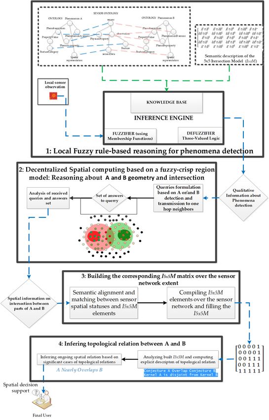
Sensors 2021, 21, 6840 8 of 26

 Figure 4. The seven possible relative spatial positions of sensor nodes towards the geometry of a
 monitored phenomenon.

 In Figure 4, the spatial state of sensor nodes is identified by the relative position of
 the sensor towards the different topological parts of the spatial object.

 3.1. The Conceptual Framework of the Proposed Approach
 In multisensory networks, sensor nodes may use several sensing units to observe
 different phenomena in order to compute meaningful information [37]. The rapid evolu‐
 tion of microprocessors and nanofabrication techniques provides a basis for the rapid evo‐
 lution of sensors [38]. Such sensors can compute meaningful information from sensed
 data, reduce the communication load to relevant information, and therefore reduce the
 consumption of energy [39].
 The conceptual framework of our approach used in computing fuzzy spatial relations
 from sensor observation is made of four steps, as shown in Figure 5.
Sensors 2021, 21, 6840 9 of 26

 Figure 5. Conceptual framework for computing fuzzy spatial relations using in SN.
Sensors 2021, 21, 6840 10 of 26 To compute fuzzy spatial relations that may hold between two sensed phenomena with vague boundaries, a sensing agent should be able to resolve the issue of fuzziness in observed properties while computing the detection of monitored phenomena [40] and spatial information about phenomena geometry and intersections through collaboration among linked nodes. The proposed approach is composed of four main steps, which are: 1. Local fuzzy rule‐based detection of monitored phenomena: in this step, sensor nodes use a built‐in reasoning engine to evaluate the membership of their location to differ‐ ent parts of a monitored phenomenon (see Figure 4). This reasoning is based on the definition of a membership function (MF) and the semantics of observed data at a given time. Defuzzification rules based on three‐valued logic are also set accordingly for each of the monitored phenomena (see Section 3.1.1). 2. Decentralized spatial computing based on a fuzzy‐crisp region model: this stem is focused on fuzzy inference of spatial boundaries and local inference of intersection between monitored phenomena: each node collaborates with one‐hop neighbors based on their phenomenon detections and the semantics of the adopted spatial model to infer their relative position to phenomenon boundaries (see Section 3.1.2). 3. Building the corresponding matrix over the sensor network extent: this is completed by aggregating distributed spatial information about the intersection among sensed phenomena over the SN, by aligning local inferred intersection by sen‐ sors with elements (see Section 3.1.3). 4. Inferring the topological relation that holds between two monitored phenomena: this is completed using the corresponding explicit spatial description of a topo‐ logical relation that holds among monitored phenomena, which is computed on a real‐time basis (see Section 3.1.4). 3.1.1. Fuzzy Rule‐Based Detection of Monitored Phenomena This is the first step of the proposed approach. Using a built‐in reasoning engine, each sensor evaluates its membership to different parts of the spatial extent of monitored phenomena using membership functions (MFs) and the recorded data at a given time. MFs by definition cope with the semantics of sensor data and the ones of the monitored phenomena [41]. Considering the semantic description of a fuzzy‐crisp object made of a kernel, conjecture and outside parts modeling monitored phenomena, the fuzzy set ob‐ tained from sensor data membership evaluation is transformed into a crisp set using three‐valued logic to define IF‐Then rules to be executed for defuzzification process [24]. From the defuzzification process, the fuzzy set made of sensor data is translated into a set of spatial qualitative values expressing if the sensor location belongs to the vague object representing the phenomenon (kernel or conjecture) or if it is out of the spatial extent of monitored phenomenon. To compute local spatial information about the detection of sensed phenomena A and B, our approach uses two functions defined as follows: → 0,1 | 0,1,2 → 0,1 | 0,1,2 functions and are defined for the detection of phenomenon A and B, respectively, by a given sensor in accordance with their semantics. Their images are represented on two bits where the first bit expresses the detection (value = 1) or non‐de‐ tection (value = 0); the second bit defines to which topological part of the spatial extent of a detected phenomenon the location of belongs; this is defined as follows: 0 → exter‐ nal (only when not detected); 1 → kernel and 2 → conjecture. The second step in our approach is devoted to decentralized reasoning for bounda‐ ries detection and intersection analysis between monitored phenomena by sensors.
Sensors 2021, 21, 6840 11 of 26 3.1.2. Decentralized Spatial Computing Based on a Fuzzy‐Crisp Region Model This is the second step of the approach. A node detecting the monitored phenomenon can guess border detection but will not identify boundary vertices with certainty. A third function is used to define boundary detection for each of a monitored phenomenon by a node . ℎ → 0,1,2 Its image is represented on a third bit using three values as follows: 0 → no boundary detected, 1 → inner boundary position and 2 → outer boundary position. These relative boundary positions are set for the kernel and the conjecture part. In this way, seven dif‐ ferent sensor states describing the fuzzy spatial extent of a phenomenon are coded using three bits as follows: [0 0 0] for outer nodes, [1 1 0] for kernel inner nodes, [1 1 1] for kernel inner boundary nodes, [1 1 2] for kernel outer boundary nodes, [1 2 0] for conjecture inner nodes, [1 2 1] for conjecture inner boundary nodes and [1 2 2] for conjecture outer bound‐ ary nodes (see Figure 4). For the perspective of building the modeling the fuzzy spatial relation that holds between A and B, boundary indeterminacy is solved by using the lower or upper fuzzy approximation suggested in [42]. In our approach, we choose the lower approxima‐ tion and consider the inner boundary position of kernel or conjecture part as the boundary positions. This approximation allows us to omit the inner and outer boundary spatial states in favor of a single boundary spatial state. The 25 relevant states which may be obtained by sensors from the inferred geometry of two monitored phenomena and coded on six bits are presented in Table 1. Table 1. Possible sensor spatial states. Sensor Spatial State Spatial Meaning Sensor Spatial State Spatial Meaning [0 0 0][0 0 0] Exterior (A) ∩ Exterior (B) ≠ Ø [1 1 1][1 1 0] Kernel boundary (A) ∩ kernel (B) ≠ Ø Kernel boundary (A) ∩ Kernel bound‐ [1 1 0][0 0 0] kernel (A) ∩ Exterior (B) ≠ Ø [1 1 1][1 1 1] ary (B) ≠ Ø Kernel boundary (A) ∩ Exterior (B) ≠ Kernel boundary (A) ∩ conjecture (B) ≠ [1 1 1][0 0 0] [1 1 1][1 2 0] Ø Ø Kernel boundary (A) ∩ conjecture [1 2 0][0 0 0] conjecture (A) ∩ Exterior (B) ≠ Ø [1 1 1][1 2 1] boundary (B) ≠ Ø Conjecture boundary (A) ∩ Exterior [1 2 1][0 0 0] [1 2 0][1 1 0] Conjecture (A) ∩ kernel (B) ≠ Ø (B) ≠ Ø Conjecture (A) ∩ kernel boundary (B) ≠ [0 0 0][1 1 0] Exterior (A) ∩ kernel (B) ≠ Ø [1 2 0][1 1 1] Ø [0 0 0][1 1 1] Exterior (A) ∩ kernel boundary(B) ≠ Ø [1 2 0][1 2 0] Conjecture (A) ∩ conjecture (B) ≠ Ø Conjecture (A) ∩ conjecture boundary [0 0 0][1 2 0] Exterior (A) ∩ conjecture (B) ≠ Ø [1 2 0][1 2 1] (B) ≠ Ø Exterior (A) ∩ conjecture boundary Conjecture boundary (A) ∩ kernel (B) ≠ [0 0 0][1 2 1] [1 2 1][1 1 0] (B) ≠ Ø Ø Conjecture boundary (A) ∩ kernel [1 1 0][1 1 0] kernel (A) ∩ kernel (B) ≠ Ø [1 2 1][1 1 1] boundary (B) ≠ Ø Conjecture boundary (A) ∩ Conjecture [1 1 0][1 1 1] kernel (A) ∩ kernel boundary (B) ≠ Ø [1 2 1][1 2 0] (B) ≠ Ø Conjecture boundary (A) ∩ Conjecture [1 1 0][1 2 0] kernel (A) ∩ conjecture (B) ≠ Ø [1 2 1][1 2 1] boundary (B) ≠ Ø kernel (A) ∩ conjecture boundary (B) [1 1 0][1 2 1] ≠Ø
Sensors 2021, 21, 6840 12 of 26

 The modeling evolving fuzzy spatial relations are populated by relevant sen‐
 sors spatial states from these 25 states when inferred from sensor measurements and col‐
 laborations.

 3.1.3. Building the Corresponding Matrix over the Sensor Network Extent
 Aggregating the whole set of partial spatial information computed over the SN extent
 is required for building a holistic view about the observed phenomena and inferring ex‐
 plicit knowledge about the fuzzy spatial relation that holds among them. From this third
 step of the approach, the I5X5 M modeling the fuzzy spatial relation that holds in the
 monitored space is built by aggregating distributed spatial information on the intersection
 of A and B, computed over the SN. Information exchange and aggregation in SN follow
 the network topology and should respect a routing protocol to avoid redundant and use‐
 less transmission of information for energy economy and fast delivery [43].
 An appropriate route is required for the optimum transmission of information
 from/to each node to/by the sink to ensure minimum transmission of information by in‐
 termediate nodes and therefore an economy of energy and fast delivery [43]. The mini‐
 mum spanning tree (MST), which determines for every node the optimum route to the
 target (sink/sensor node), should be established from the communication network which
 is theoretically represented following the RNG (Relative Neighborhood Graph) or GG
 (Gabriel Graph) graphs [43]. These two graphs are built based on sensor spatial range
 (communication or observation) whose extent corresponds to the diameter of the contain‐
 ing circle; the RGN graph does not allow any overlapping among the containing circle,
 while the GG graph does. The MST is used during the propagation of information, in‐
 structions or queries among sink and sensor nodes. Each node therefore knows its chil‐
 dren nodes and also its parent node through which the final spatial information to be
 transmitted to the sink should be conveyed.
 A sink node is elected among the sensors of the network; the sink node stores an
 , whose elements are all set to 0 corresponding to an empty set (Ø). From the detec‐
 tion of monitored phenomena and their geometries, each node set its spatial state, which
 is in alignment with an item of the identified as , , where i and j correspond
 to the number of the line and column. If a sensor’s spatial state is equal to: [1 1 1][1 1 1],
 the sensor will send a message containing , 1 to its parent over the spanning
 tree. This message corresponds to ∩ ∅ , 1 as illustrated in Equation
 (4) for a given sensor Si.
 If spatial_state (Si) = [1 1 1][1 1 1] then ∩ ∅ , 1 (4)
 Over the spanning tree branches linking nodes to the sink node, the sensor spatial
 states, translated into , elementary values, are aggregated from the end child node
 to the last parent node (sink). Redundant values are ignored during the aggregation pro‐
 cess; the set of , elementary values collected over the spanning tree at a given time
 is inserted in while the others remain with a value of zero. Such filled rep‐
 resents the fuzzy spatial relation that holds between phenomena A and B and their parts.
 Hence, the structure of the matrix can be used for inferring an explicit spatial description
 of the fuzzy spatial relation that holds between monitored phenomena.

 3.1.4. Inferring the Topological Relation that Holds between Two Monitored Phenomena
 Topological relations describe how humans perceive spatial configurations between
 objects in reality and they constitute a significant part of information in human commu‐
 nication by natural language. We may say, for instance, that a certain geographic region
 is adjacent to, contained in or overlapping with another [44]. If we consider two vague‐
 shaped regions A and B involved in a fuzzy spatial relation, we may use the taxonomy of
 fuzzy spatial relations proposed by Clementini and Di Felice [33]. This taxonomy is a good
 communication tool but it lacks specific information that can help the end user in building
Sensors 2021, 21, 6840 13 of 26 an appropriate image of the monitored reality. For instance, saying A meets or nearly overlaps B may not provide enough information to the end user to have a good picture of the scene as is illustrated in Figure 2. Taking advantage of the fine observation of sensors and their ability to infer meaningful spatial information, we may further describe this us‐ ing other topological information as: Conjecture of A overlaps the conjecture of B Conjecture of A overlaps the kernel and conjecture of B Conjecture of B overlaps the kernel and conjecture of A Conjecture of A overlaps the kernel and conjecture of B, and the kernel of A overlaps conjecture of B Kernel of A is disjoined from the kernel of B, or the conjecture of A is disjoined from conjecture of B Using , one can say region A meets region B, providing users with qualitative information to describe the evolving spatial relations between A and B, which is relevant for SDSS and many other GIS applications. With the proposed approach, we will be able to derive such qualitative information describing inferred fuzzy spatial relations using elements. For this purpose, some reasoning rules are set on the basis of struc‐ ture to infer if a topological part of A overlaps or contains another topological part of B and vice versa. In the following examples, three cases of fuzzy spatial relations between topological parts of A and B extracted using the components of are presented. The reasoning rules for the specific relations illustrated in Figure 6 are presented as follows: If ℳ , the reasoning rules can be formulated as follows for illustration: If ℳ 1,1 ℳ 2,2 ℳ 3,3 3, then kernel A overlaps kernel B (this means, for example, that the intersections kernel of A with kernel of B; boundary of kernel of A with boundary of kernel of B and exterior of kernel of A with exterior of kernel of B are not empty sets ie ≠ Ø) If ℳ 5,1 ℳ 4,2 ℳ 3,3 3, then conjecture A overlaps kernel B If ℳ 5,5 ℳ 4,4 ℳ 3,3 3, then conjecture A overlaps conjecture B If ℳ 1,5 ℳ 2,4 ℳ 3,3 3, then kernel A overlaps conjecture B It should be noted that overlapping excludes the containing or covering relation be‐ tween two parts; that being said, if the predicate overlap is set as true between kernel A and kernel B, the predicate contain or cover cannot be set as true between these two parts. 1 1 0 0 1 1 1 1 1 ⎡1 1 1 ⎤ ⎢ ⎥ 0 ⎢1 1 1 ⎥ kernel A overlaps kernel B 0 ⎢ ⎥ ⎣ 1 ⎦ 1 1 0 0 1 1 ⎡ ⎤ ⎢1 1 1 ⎥ 0 ⎢ ⎥ conjecture A overlaps kernel B 0 ⎢1 1 1 ⎥ ⎣1 1 1 1⎦ 1 1 0 0 1 1 0 1 ⎡1 0⎤ ⎢ ⎥ 0 ⎢ ⎥ kernel A is within kernel B or kernel B contains kernel A 0 ⎢ ⎥ ⎣ 1⎦ 0 1 Figure 6. Illustration of three cases of fuzzy spatial relations between topological parts of A and B sensed phenomena, inferred from structure.
Sensors 2021, 21, 6840 14 of 26
Evaluating the relation of the type contain or cover between parts of A and B depends
on units expressing the intersection of any part of A or B and the exterior of the
related phenomenon. For instance: if ∩ Ø and ∩ Ø, the kernel of A is
contained by a given part of B. Identifying which part of B contains the kernel A is neces‐
sary; if kernel A overlaps kernel B then we can check if the conjecture of B contains kernel
A: ∩ Ø and ∩ Ø
These rules can be formally written as follows:
If ℳ 1,5 ℳ 2,5 0 ℳ 1,1 ℳ 2,2 ℳ 3,3 3
ℳ 1,1 ℳ 2,1 2 ℎ
If ℳ 1,5 ℳ 2,5 0 ℳ 1,1 ℳ 2,2 ℳ 3,3 3
ℳ 1,1 ℳ 2,1 2 ℳ 1,3 ℳ 2,3
2 ℎ
Kernel A and kernel B will be called disjoint if the overlap predicate is set as false and
predicate cover or contain is set as false also. The rule used to evaluate the disjunction
between kernel A and kernel B is formalized as follows:
If ℳ 1,5 ℳ 2,5 2 ℳ 5,1 ℳ 5,2 2 ℳ 1,1 ℳ 2,2
ℳ 3,3 3
Equality between parts is established if the overlap predicate is true and the cover or
contain predicate is jointly true for the two parts, but the containing or covering parts are
jointly undefined; equality jointly involves overlapping and parthood as shown in the
conceptual neighborhood graph of RCC8 [45]. For equality between kernel A and kernel
B, the reasoning rule can be set as follows:
If ℳ 1,5 ℳ 2,5 0 ℳ 5,1 ℳ 5,2 0 ℳ 1,1 ℳ 2,2
ℳ 3,3 3 ℳ 1,1 ℳ 1,2 2 ℳ 1,1 ℳ 2,1
2
Such rules are formulated for other parts of fuzzy‐crisp regions A and B based on the
structure presented in Equation (3). The formal presentation of the approach is
broadly presented in the next section.
The detailed structure of is used for providing a more explicit description of
the inferred topological relation from sensor network data for more effective support to
SDSS. This constitutes a major contribution of this research.
3.2. Formal Presentation of Proposed Approach
As presented earlier, sensors need to collaborate with their linked neighbors and use
a built‐in reasoning engine to infer partial spatial information on the monitored phenom‐
ena of vague spatial shape. This reasoning process allows us to start work on fine grain
spatial information observed by the individual sensors nodes in Sn and infer topical rela‐
tions between the observed phenomena through an aggregation process using the ele‐
ments of information in the . Hence, the sink node in SN uses a built‐in reasoning
engine to compute spatial relation modeled using the information in . The whole
process described in former sections is summarized in the following algorithm presented
in Algorithm 1.
Algorithm 1 Fuzzy spatial relation modeling by I5x5M in sensor networks
1: Variables: SN = {s1,s2,...,sn}; SensorNetwork
2: S‐On, D‐Ons; a sensor ontology, a domain ontologies
3: I5X5M; Intersection matrix modeling the fuzzy spatial relation between A and B
4: fA(si) → {(0,1)|(0,1,2)}; Function used to detect A
5: gB(si) → {(0,1)|(0,1,2)}; Function used to detect B
6: h(s)→ {0,1,2}; Function used to detect the boundaries of A or B
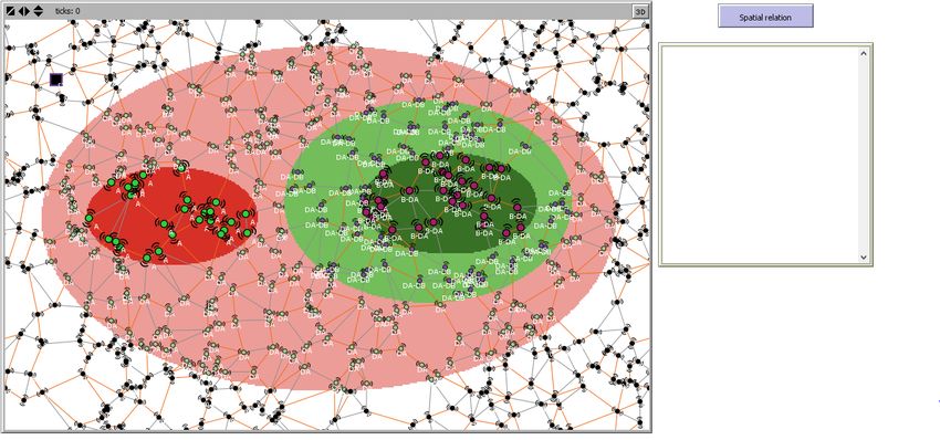
7: SpTr(SN); Built spanning tree over the sensor network
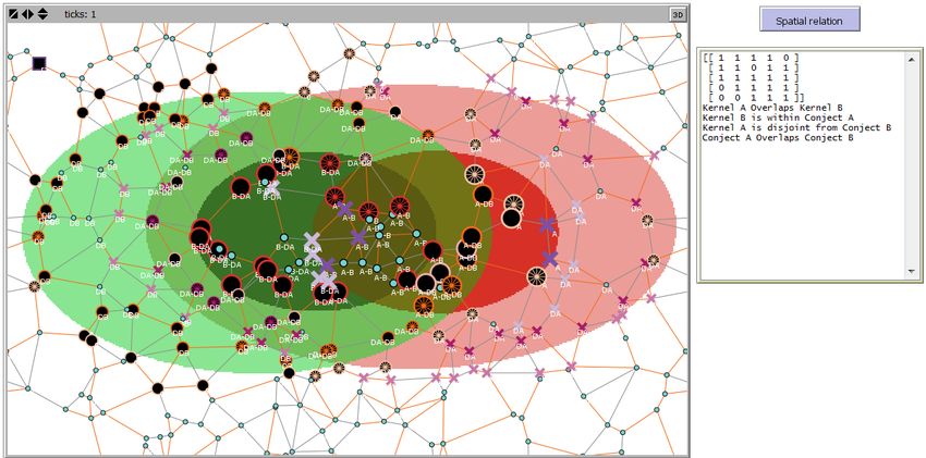
8: BeginSensors 2021, 21, 6840 15 of 26 9: Setting the sensor network; establishing communication links among nodes 10: Build the spanning tree (SpTr(SN)) over the SN topology 11: Detection of the phenomenon A is computed over the SN: fA(SN) 12: Detection of phenomenon B is computed over theSN:gB(SN) 13: Decentralized spatial computing of A and B boundaries over the SN:h(si(AB)) 14: Compute spatial state from detected phenomena and boundaries: (si([x,y,z][x y z]) 15: Aggregate sensor spatial state 16: From the last child node to sink node along SpTr(SN) 17: Compile spatial states ofunequal value 18: Compute I5x5M by alignment between spatial states values and I5X5M elements 19: If...then Inference ofqualitative specifications about fuzzy spatial relationfrom I5X5M 20: End. Evaluating the performance of this approach and its applicability is a priority of this research. For this purpose, the corresponding computer program was implemented within a multi‐agent programming software named Netlogo. 4. Case Study and Results The program, developed here with Netlogo, loads geospatial scenes made of vague‐ shape phenomena; sensors equipped with a built‐in reasoning engine compute the detec‐ tion of phenomena and their boundaries. From these boundaries, the nature of relations that holds between detected phenomena is computed. These relations are modeled with , from which qualitative spatial specifications about these relations are inferred. The 44 realizable fuzzy relations between vague‐shape spatial objects [46] are adapted for rea‐ soning with sensor data and are implemented in this research. As a first case study, we use sensor data on two vague‐shaped phenomena observed by an SN. These phenomena include a bush fire (A in red color for the kernel and light red for the conjecture) and wild shrubby vegetation (B with green color and light green for the kernel and conjecture, respectively). The SN has a sink node and sensor nodes that receive information from other sensors in the network through their communication sys‐ tems. Without boundary detection, it is not possible to infer spatial information about the relation between A and B. This is why the output of the spatial relation reasoning section on the right of the figure is empty, as shown in Figure 7; after boundaries detection, com‐ puting the spatial relation between A and B will yield the corresponding and qual‐ itative spatial specification about the relation between A and B. In Figure 7, black lack nodes represent sensors in the outer part of the phenomena while colored nodes express the detection of the phenomena. In addition, the differences in sizes of the nodes express the parts of spatial extent of the observed phenomena (kernel, conjecture). The lines represent communication links, and when colored in orange, the links are part of the spanning tree.
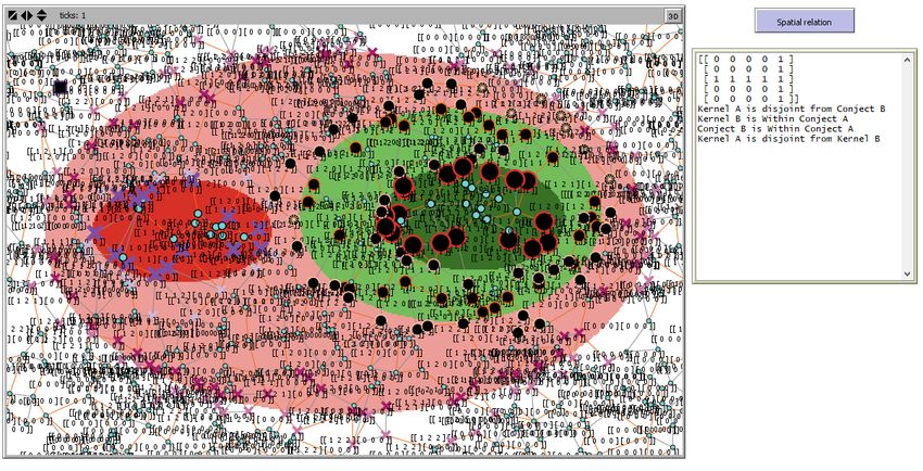
Sensors 2021, 21, 6840 16 of 26

 Figure 7. Excerpt of Netlogo environment showing A’s boundary covering B within SN extent.

 The output of decentralized spatial reasoning for boundaries detection changes the
 shape of nodes detecting phenomena boundaries, and the elements are aligned
 with the sensors’ spatial state; updated is inserted in the output area followed by a
 spatial description of the scene computed from structure and elements value; this
 is shown in Figure 8.
 The approach yields compelling results for all the 44 realizable fuzzy spatial rela‐
 tions; this was effective for an SN in which sensors were adequately distributed over the
 spatial extent of the observed spatial scene to enable the detection of any spatial dynamic
 phenomena and their interactions over the scene. The results obtained for the 44 realizable
 fuzzy relations identified in [46] are presented in Appendix A. This Appendix A gives, for
 each type of fuzzy spatial relation, a view of the corresponding scene from which the de‐
 rived is given with the inferred description of the monitored scene.

 (a)
Sensors 2021, 21, 6840 17 of 26

 (b)
Figure 8. (a) The SN showing sensor spatial states as the sensor label after boundary detection and intersection analysis and (b)
enlargement of the output showing resulting and explicit describing the fuzzy spatial relation.

 5. Discussion
 Former research on decentralized computation on the spatial relationships between
 sensed phenomena was based on RCC8 (eight spatial relations) and did not consider the
 possible vague shape and broad boundaries of sensed phenomena [47]. The proposed ap‐
 proach took advantage of the structure to consider the fuzzy nature of real‐world
 phenomena and could consistently model 44 cases of topological relations that can hold
 between sensed phenomena of vague shapes. Inferred descriptions of evolving spatial re‐
 lationships from built give an opportunity to redraw a spatiotemporal representa‐
 tion of monitored reality that can enhance spatial decision support systems.
 From detected phenomena, our approach can build the corresponding from
 which an explicit description of the monitored scene with the presence of vague spatial
 phenomena and their interactions is inferred on a near real‐time basis. Instead of just de‐
 claring the nature of the relation between sensed phenomena, the provided description
 may help in depicting the scene for decision‐making processes. For instance, instead of
 just saying A and B are strongly overlapping because their kernels overlap each other,
 their conjectures may either be equal, overlapping, or one is contained in the other. Such
 an inferred description is necessary in guiding robots or autonomous engines over sensed
 phenomena.
 The use of a wide‐range sensor lightly distributed over the area of interest where
 observations are carried may result in some imprecision in inferred spatiotemporal infor‐
 mation from which reasoning about the spatial relation is carried, therefore yielding poor
 and imperfect spatial knowledge, as shown in Figure 9.
Sensors 2021, 21, 6840 18 of 26

 Figure 9. Poor modeling and qualitative specifications about a given scene monitored by a light dense SN of wide range
 sensors (case of scene 19).

 Such a poorly distributed sensor network may not capture the essential spatial infor‐
 mation about the intersection between monitored phenomena and yield a which
 does not conform to a real‐world scene. This may lead to poor and inadequate spatial
 decisions. For many applications, it is required that each point of the region is covered by
 at least k (k > 1) sensors [48]; in our case, the spatial distribution of sensors should be set
 in order to assure that all relevant information depicting an ongoing scene is captured.
 Adequate spatial distribution of sensors on the field, concomitantly depends on the per‐
 formance of sensors (observation range), their relative position and their density. A GIS‐
 based approach for optimal distribution and positioning of sensors was developed by Ar‐
 gany and Mostafavi in [49], which can be combined with the proposed approach in this
 paper to improve the coverage of the SN as well as its efficiency in monitoring and detect‐
 ing the information and events of interest in a given spatial scene.
 On the other hand, some real‐world phenomena may be adequately represented us‐
 ing more complex fuzzy‐crisp object models. For instance, we may consider cases that
 objects may have several kernel parts or include islands. Modeling and analyzing topo‐
 logical relations that hold between such phenomena using was not tested in this
 research. Future investigations will also concern reasoning and computing continuous
 change in topological relations between monitored phenomena in sensor networks.
 Finally, it should be noted that the implementation and integration of the proposed
 algorithm in a specific type of sensor were not explored in this study. Further investiga‐
 tions would be necessary to estimate to what extent we need to optimize the operations
 so that each sensor node is able to carry out all the proposed operations for continuously
 inferring qualitative information on spatial relations of detected phenomena without the
 burden on its energy consumption and communication capacities. This project is a part of
 ongoing research on sensor network deployment and exploitation in natural and built
 environments and further progress on our results will be reported in upcoming publica‐
 tions.

 6. Conclusions and Future Works
 This research has given us the opportunity to develop a decentralized fuzzy rule‐
 based approach for sensor networks for reasoning about fuzzy spatial relations and inter‐
 actions between two monitored spatial dynamic phenomena uncertain boundaries. In this
 approach, we assumed that multi‐sensors and a sink node were organized in an SN and
Sensors 2021, 21, 6840 19 of 26

 are equipped with a built‐in reasoning engine enabling effective detection of at least two
 monitored phenomena modeled with a fuzzy‐crisp spatial model whose geometries are
 made of kernel and conjecture parts. The fuzzy‐crisp object adopted in this research, as a
 best representation of vague phenomena, is composed of five topological parts including
 the kernel, the conjecture and the exterior, and their boundary zones from which the 5x5
 intersection model ( ) is built. The use of an helps in modeling the possible
 spatial relation based on the intersection between the five topological parts of two vague‐
 shaped phenomena that are observed by an SN. Our proposed original approach allows
 inferring qualitative specifications about the captured spatial relation between two vague‐
 shaped phenomena at a given time from the structure of the resulting . This pro‐
 vides valuable information for an SDSS which can enable any user or intelligent agent to
 easily analyze the real‐time situation and decide on the actions to be taken. Testing the
 proposed approach yielded compelling results for the 44 realizable fuzzy spatial relations
 that may hold between two given phenomena with a vague shape monitored by SN.
 In future work, it will be interesting to consider the implementation of the proposed
 algorithm in SN composed of sensors with nano‐computing capacities and test it in a real‐
 world application. The evaluation of the performance of such a network with an optimal
 placement of its sensor nodes would be another interesting avenue for further investiga‐
 tions.

 Author Contributions: Conceptualization, R.C.N.N. and M.A.M.; methodology, R.C.N.N.; soft‐
 ware, R.C.N.N.; validation, R.C.N.N., M.A.M. and J.B.; formal analysis, R.C.N.N. and M.A.M.; in‐
 vestigation, R.C.N.N.; resources, M.A.M.; data curation, writing—original draft preparation,
 R.C.N.N.; writing—review and editing, R.C.N.N., M.A.M. and J.B.; visualization, supervision,
 M.A.M. and J.B.; project administration, M.A.M.; funding acquisition, M.A.M. All authors have read
 and agreed to the published version of the manuscript.
 Funding: This research was funded by PEFOGRN‐BC as well as the National Sciences and Engi‐
 neering Research Council (NSERC) of Canada.
 Institutional Review Board Statement: Not applicable.
 Informed Consent Statement: Not applicable.
 Data Availability Statement: Not applicable.
 Conflicts of Interest: The authors declare no conflict of interest.
Sensors 2021, 21, 6840 20 of 26

Appendix A

 Table A1. Spatial Modeling of 44 Fuzzy Spatial Relations Using the .

 Scene

 Resulting and
 inferred spatial description
 of the relation

 Corresponding spatial
 1:Disjoint 2:Meet 3: nearly Overlap 4:covered by Boundary 5: covered by Boundary
 relation

 Scene

 Resulting and
 inferred spatial description
 of the relation

Sensors 2021, 21, 6840. https://doi.org/10.3390/s21206840 www.mdpi.com/journal/sensors
Sensors 2021, 21, 6840 21 of 26

 Corresponding spatial
 6: nearly Overlap 7:covers with Boundary 8:covers with Boundary 9: nearly Overlap 10:covered by Boundary
 relation

 Scene

 Resulting and
 inferred spatial description
 of the relation

 Corresponding spatial
 11: covered by Boundary 12:covers with Boundary 13:covers with Boundary 14:boundary Overlap 15:boundary Overlap
 relation

 Scene
Sensors 2021, 21, 6840 22 of 26

 Resulting and
 inferred spatial description
 of the relation

 Corresponding spatial
 16:boundary Overlap 17:boundary Overlap 18:Overlap 19:nearly Covered by 20:nearly Covered by
 relation

 Scene

 Resulting and
 inferred spatial description
 of the relation

 Corresponding spatial
 21:nearly Covers 22:nearly Covers 23:strongly Overlap 24:strongly Overlap 25:strongly Overlap
 relation

 Scene
Sensors 2021, 21, 6840 23 of 26

 Resulting and
 inferred spatial description
 of the relation

 Corresponding spatial
 26:strongly Overlap 27: covered by 28:nearly Covered by 29:nearly Fill 30:nearly Fill
 relation

 Scene

 Resulting and
 inferred spatial description
 of the relation

 Corresponding spatial
 31:nearly Fill 32:nearly Fill 33: covers 34: nearly Covers 35: nearly Filled by
 relation

 Scene
Sensors 2021, 21, 6840 24 of 26

 Resulting and
 inferred spatial description
 of the relation

 Corresponding spatial
 36: nearly Filled by 37: nearly Filled by 38: nearly Filled by 39: Inside 40: Contains
 relation

 Scene

 Resulting and
 inferred spatial description
 of the relation

 Corresponding spatial
 41: Equal 42: nearly Equal 43: nearly Equal 44: nearly Equal
 relation
Sensors 2021, 21, 6840 25 of 26

References
1. Bröring, A.; Maúe, P.; Janowicz, K.; Nüst, D.; Malewski, C. Semantically‐enabled sensor plug & play for the sensor web. Sensors
 2011, 11, 7568–7605. https://doi.org/10.3390/s110807568.
2. Rodriguez, C.C.G.; Servigne, S. Sensor Data Quality for Geospatial Monitoring Applications. In Bridging The Geographic Infor‐
 mation Sciences, Proceedings of the AGILE’2012 International Conference on Geographic Information Science, Avignon, France, 24–27
 April 2012; Gensel, J., Josselin, D., Vandenbroucke, D., Eds.; Springer: Berlin/Heidelberg, Germany, 2012; pp. 111–116.
3. Nittel, S. A survey of geosensor networks: Advances in dynamic environmental monitoring. Sensors 2009, 9, 5664–5678.
 https://doi.org/10.3390/s90705664.
4. Carniel, A.C.; Schneider, M.; Ciferri, R.R. FIFUS: A Rule‐Based Fuzzy Inference Model for Fuzzy Spatial Objects in Spatial Da‐
 tabases and GIS. In Proceedings of the SIGSPATIAL, Seattle, WA, USA, 3–6 November 2015; p. 4.
5. Pauly, A.; Schneider, M. Vague Spatial Data Types. In Encyclopedia of GIS SE—1434; Springer: Boston, MA, USA, 2008; pp. 1213–
 1217, ISBN 978‐0‐387‐30858‐6.
6. Dube, M.P. Topological augmentation: A step forward for qualitative partition reasoning. J. Spat. Inf. Sci. 2017, 14, 1–29.
 https://doi.org/10.5311/JOSIS.2017.14.288.
7. Laurini, R. Some Philosophical Issues Regarding Geometric Modeling for Geographic Information and Knowledge Systems. In
 The Philosophy of GIS; Tambassi, T., Ed.; Springer Nature Switzerland: Cham, Switzerland, 2019; pp. 25–50, ISBN 978‐3‐030‐
 16828‐5.
8. Guo, J.; Wang, Z.; Duan, Y. A fuzzy semantic spatial partitioning model of regions and applications in understanding remote
 sensing data. J. Intell. Fuzzy Syst. 2019, 36, 689–707. https://doi.org/10.3233/JIFS‐171662.
9. Roy, A.J.; Stell, J.G. Spatial relations between indeterminate regions. Int. J. Approx. Reason. 2001, 27, 205–234.
 https://doi.org/10.1016/S0888‐613X(01)00033‐0.
10. Egenhofer, M.J.; Herring, J. Categorizing Binary Topological Relations between Regions, Lines, And Points in Geographic Databases;
 1990. Tech. rep. 90‐12. National Center for Geographic Information and Analysis, University of California, Santa Barbara, Santa
 Barbara, CA
11. Egenhofer, M.J.; Franzosa, R.D. Point‐set topological spatial relations. Int. J. Geogr. Inf. Syst. 1991, 5, 161–174.
 https://doi.org/10.1080/02693799108927841.
12. Randell, D.A.; Cui, Z.; Cohn, A.G. A spatial logic based on regions and connection. In Proceedings of the 3rd International Confer‐
 ence On Knowledge Representation And Reasoning; Nebel, B., Rich, C., Swartout, W., Eds.; Morgan Kaufmann: Cambridge, MA,
 USA, 1992; Volume. 92, pp. 165–176.
13. Clementini, E.; Di Felice, P.; van Oosterom, P. A small set of formal topological relationships suitable for end‐user interaction.
 In Proceedings of the Advances in Spatial Databases; Abel, D., Chin Ooi, B., Eds.; Springer Berlin Heidelberg: Berlin/Heidelberg,
 Germany, 1993; pp. 277–295.
14. Li, Y.; Li, S. A fuzzy sets theoretic approach to approximate spatial reasoning. Fuzzy Syst. IEEE Trans. 2004, 12, 745–754.
 https://doi.org/10.1109/TFUZZ.2004.836100.
15. Baode, J.; Qi, W.D. An Intersection Model of RCC‐5 for Spatial Relationships and its Application. J. Softw. Eng. 2017, 11, 102–
 108. https://doi.org/10.3923/jse.2017.102.108.
16. Compton, M.; Barnaghi, P.; Bermudez, L.; Garcia‐Castro, R.; Corcho, O.; Simon, C.; Graybeal, J.; Hauswirth, M.; Henson, C.;
 Herzog, A.; et al. The SSN ontology of the W3C semantic sensor network incubator group. Web Semant. Sci. Serv. Agents World
 Wide Web 2012, 17, 25–32. https://doi.org/10.1016/j.websem.2012.05.003.
17. Wu, C. Detailed model of topological and metric relationships between a line and region. Arab. J. Geosci. 2019, 12.
 https://doi.org/10.1007/s12517‐019‐4273‐8.
18. Tang, X.; Kainz, W.; Wang, H. Topological relations between fuzzy regions in a fuzzy topological space. Int. J. Appl. Earth Obs.
 Geoinf. 2010, 12, S151–S165. https://doi.org/10.1016/j.jag.2010.01.004.
19. Schneider, M.; Behr, T. Topological Relationships Between Complex Spatial Objects. ACM Trans. Database Syst. 2006, 31, 39–81.
 https://doi.org/10.1145/1132863.1132865.
20. Dube, M.P.; Egenhofer, M.J. Binary topological relations on the digital sphere. Int. J. Approx. Reason. 2020, 116, 62–84.
 https://doi.org/10.1016/j.ijar.2019.10.008.
21. Shen, J.; Chen, M.; Yue, S. A distance‐based topological relation model between spatial regions. Arab. J. Geosci. 2018, 11, 11.
 https://doi.org/10.1007/s12517‐018‐4146‐6.
22. Schneider, M. Fuzzy spatial data types for spatial uncertainty management in databases. In Handbook of Research on Fuzzy Infor‐
 mation Processing in Databases; IGI Global: Hershey, PA, USA, 2008; pp. 490–515.
23. Guan, L.‐J.; Duckham, M. Decentralized Reasoning about Gradual Changes of Topological Relationships between Continuously
 Evolving Regions. In Spatial Information Theory SE—8; Egenhofer, M., Giudice, N., Moratz, R., Worboys, M., Eds.; Lecture Notes
 in Computer Science; Springer Berlin Heidelberg: Berlin/Heidelberg, Germany, 2011; Volume 6899, pp. 126–147, ISBN 978‐3‐
 642‐23195‐7.
24. Ntankouo Njila, C.R.; Mostafavi, M.A.; Brodeur, J. Modelling Vague Shape Dynamic Phenomena from Sensor Network data
 using a Decentralized Fuzzy Rule‐Based Approach. In Proceedings of the International Conference on GIScience Short Paper
 Proceedings, Montreal, QC, Canada, 27–30 September 2016; Volume 1.
You can also read