A first outline of the Quaternary landscape evolution of the Kashaf Rud River basin in the drylands of northeastern Iran
←
→
Page content transcription
If your browser does not render page correctly, please read the page content below
Express report
E&G Quaternary Sci. J., 70, 145–150, 2021
https://doi.org/10.5194/egqsj-70-145-2021
© Author(s) 2021. This work is distributed under
the Creative Commons Attribution 4.0 License.

A first outline of the Quaternary landscape evolution of the
Kashaf Rud River basin in the drylands of northeastern Iran
Azra Khosravichenar1,2 , Morteza Fattahi3 , Alireza Karimi4 , Hassan Fazeli Nashli5 , and Hans von Suchodoletz2
1 Department   of Human Evolution, Max Planck Institute for Evolutionary Anthropology, 04103 Leipzig, Germany
2 Department   of Geography, Leipzig University, 04103 Leipzig, Germany
3 Institute of Geophysics, University of Tehran, Tehran 14155-6466, Iran
4 Department of Soil Science, Faculty of Agriculture, Ferdowsi University of Mashhad, Mashhad 917794-8974, Iran
5 Department of Archaeology, University of Tehran, Tehran 14155-6466, Iran

Correspondence:          Azra Khosravichenar (azra_khosravichenar@eva.mpg.de)

Relevant dates:          Received: 28 March 2021 – Revised: 29 April 2021 – Accepted: 7 May 2021 –
                         Published: 2 June 2021

How to cite:             Khosravichenar, A., Fattahi, M., Karimi, A., Fazeli Nashli, H., and von Suchodoletz, H.: A first outline
                         of the Quaternary landscape evolution of the Kashaf Rud River basin in the drylands of northeastern
                         Iran, E&G Quaternary Sci. J., 70, 145–150, https://doi.org/10.5194/egqsj-70-145-2021, 2021.

1   Introduction                                                     Fluvial archives are very sensitive to climatic and base-
                                                                  level changes, tectonics, or human activity, making them
Naturally fragile drylands are among the most sensitive re-       valuable archives of former geomorphic and paleoenviron-
gions to climate change and human activities. More than           mental changes (Macklin and Lewin, 2008; Walker and Fat-
80 % of Iran is drylands today, of which large parts represent    tahi, 2011; Faust and Wolf, 2017; von Suchodoletz et al.,
human settlement centers (Amiri and Eslamian, 2010). Fur-         2015, 2018). Therefore, we recently studied the high moun-
thermore, the region forms a natural bridge between south-        tain Kalshour catchment in northeastern Iran, with a size
western, southern, and central Asia for human groups that         of some square kilometers, and linked fluvial activity with
mainly used three main migration corridors throughout the         regional geomorphological and hydrological changes and
Pleistocene and Early Holocene (Vahdati Nasab et al., 2013).      global solar and temperature fluctuations (Khosravichenar et
To better deal with current and future geomorphological and       al., 2020). However, to obtain robust geomorphic and pale-
ecological changes in this partly densely settled region and      oenvironmental information for the larger region, studies of
to better understand the geomorphic and paleoenvironmen-          river systems with catchments of several hundreds to thou-
tal background of former human dispersal, regional knowl-         sands of square kilometers are necessary (Faust and Wolf,
edge about such changes on longer centennial to millennial        2017) but are still lacking for this region. To fill this gap
timescales is necessary. Whereas loess–paleosol sequences         and to offer future research perspectives for this region, we
offer quite well-based information about Late Quaternary          studied the Kashaf Rud River basin in northeastern Iran with
paleoenvironmental changes in northern Iran (Kehl, 2009;          a catchment of several thousand square kilometers during a
Lauer et al., 2017), such knowledge is still rather fragmen-      field expedition in 2019 (Fig. 1). This drylands river basin
tary for the drylands of eastern and northeastern Iran and        formed part of a Pleistocene to Holocene human migration
is mostly limited to incomplete sediment records of playa         corridor, linking western and central Asia (Vahdati Nasab
lakes or alluvial fans (Walker and Fattahi, 2011; Fattahi and     et al., 2013; Fig. 1). Our goal was to build up a first field-
Walker, 2016).                                                    based outline of the Quaternary landscape evolution of the

Published by Copernicus Publications on behalf of the Deutsche Quartärvereinigung (DEUQUA) e.V.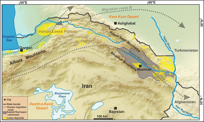
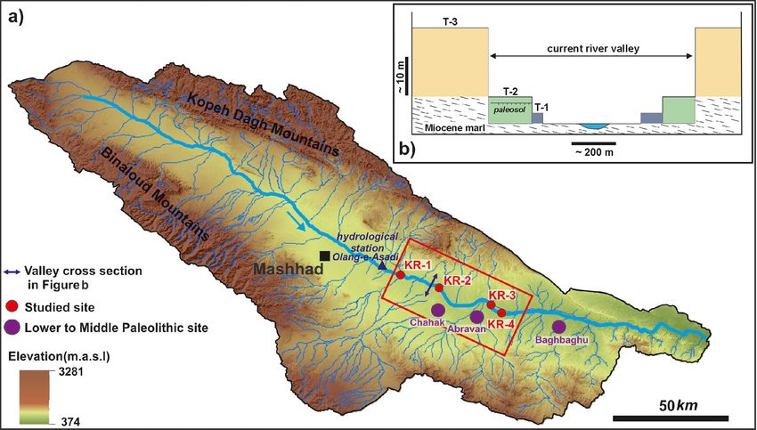
146           A. Khosravichenar et al.: A first outline of the Quaternary landscape evolution of the Kashaf Rud River basin

Figure 1. Location of the Kashaf Rud River basin (gray shaded area) in northeastern Iran (digital elevation model sources: GTOPO30,
https://earthexplorer.usgs.gov, last access: 1 March 2020; ALOS PALSAR, https://vertex.daac.asf.alaska.edu, last access: 1 March 2020),
with loess distribution (geological maps of Khorasan 1 : 1000 and 1 : 250 000; Lauer et al, 2017) and Pleistocene to Holocene human migration
corridors B and C (Vahdati Nasab et al., 2013).

river basin to (i) demonstrate its good suitability as a fluvial            We investigated a ca. 45 km long part of the river val-
archive for Late Quaternary geomorphic and paleoenviron-                 ley east of the city of Mashhad during a field expedition in
mental changes in the drylands of eastern and northeastern               2019 and mapped the main geomorphological and sedimen-
Iran and (ii) offer a first diachronic geomorphic frame for hu-          tological features. Here, the riverbed shows altitudes between
man migrations in a largely unexplored former main human                 900 and 630 m a.s.l., and precipitation is around 250 mm a−1
migration corridor (Fig. 1).                                             (https://en.climate-data.org, last access: 1 March 2020).

2   Study area and methods                                               3    Results

The ca. 290 km long northwest–southeast flowing Kashaf                   The studied part of the Kashaf Rud River valley is currently
Rud River has a catchment of ca. 16 800 km2 and a mean                   only sparsely vegetated, so its geomorphology and strati-
annual discharge of ca. 0.64 m3 s−1 (station Olang-e-Azadi               graphical features are well recognizable. The current river
1992–2007; Regional Water Company of Khorasan Razavi;                    flows in a deeply incised gorge-like valley (maximal width
Fig. 2a). The regional climate is arid to semi-arid today (pre-          ca. 0.8–1.5 km; Fig. 2b). In agreement with the findings of
cipitation ca. 150–550 mm a−1 ; https://globalweather.tamu.              Ariai and Thibault (1975), throughout most of the study
edu, last access: 1 March 2020). Large parts of the basin                area three main morphological terrace levels were observed
are currently covered with patchy loess and loess derivatives            that are largely naturally outcropped today, offering excel-
(Karimi et al., 2011; Fig. 1), and the basin formed part of              lent conditions for geomorphological and sedimentological
Pleistocene to Holocene human migration corridor C of Vah-               investigations (Fig. 3).
dati Nasab et al. (2013; Fig. 1). Accordingly, Middle and es-
pecially Lower Paleolithic stone artifacts were found at sev-                – T-1. In the lowest and youngest aggradational ter-
eral sites (Fig. 2a). In the course of the archeological investi-              race level (surface ca. 2–4 m above current river bed;
gations during the 1970s, the regional landscape context was                   Figs. 2b, 3a, c, g, h), meters-thick, mostly yellowish to
also partly studied (Ariai and Thibault, 1975; Jamialahmadi                    ochreous loamy to silty sediments overlie basal gravels
et al., 2008).                                                                 and sand. We observed no paleosols within these sedi-

E&G Quaternary Sci. J., 70, 145–150, 2021                                                  https://doi.org/10.5194/egqsj-70-145-2021
A. Khosravichenar et al.: A first outline of the Quaternary landscape evolution of the Kashaf Rud River basin                      147

Figure 2. (a) The Kashaf Rud River basin with the study area (red rectangle) and Lower to Middle Paleolithic sites (Ariai and Thibault,
1975; Jamialahmadi et al., 2008). (b) Schematic cross section through the river valley between sites KR-1 and KR-2, with the different
terrace levels (for the location, please see panel a).

     ments, and the fluvial layers are often easily recogniz-         4     Discussion and conclusions
     able (Fig. 3h).
                                                                      By combining our field observations with former findings of
  – T-2. In the middle aggradational terrace level (surface           Ariai and Thibault (1975), we reconstructed the main steps of
    ca. 5–7 m above current river bed; Figs. 2b, 3a–g),               the Quaternary landscape evolution of the Kashaf Rud River
    meters-thick, mostly yellowish to ochreous loamy to               basin as follows:
    silty sediments overlie basal gravels and sand. At most
    sites, the fluvial layers are easily recognizable (Fig. 3d).
                                                                          i. Multi-phased fluvial and lacustrine aggradation of
    At site KR-1, one weak, slightly reddish and clayey pa-
                                                                             gravelly, sandy and silty material in level T-3, indicat-
    leosol was found (Fig. 3b). Furthermore, at site KR-3
                                                                             ing varying hydrological conditions in the Kashaf Rud
    a brownish clayey paleosol was found (Fig. 3e, f). At
                                                                             River basin (Fig. 4a; Ariai and Thibault, 1975). This
    the latter site, the river flows in an artificial canal some
                                                                             level must have shown a large extension and a relatively
    100 m north of the natural river bed (Fig. 3e). Here, the
                                                                             flat topography (Fig. 2b). The higher proportion of grav-
    fluvial sediments are covered by up to > 1 m silty to
                                                                             elly and especially sandy material compared with the
    gravelly sediments originating from the northern slope
                                                                             following periods indicates a lower importance of silty
    (Fig. 3e, f).
                                                                             loess in the landscape during that time. Although the
  – T-3. In this highest and oldest aggradational terrace level              archeological finds of Ariai and Thibault (1975) from
    (surface 40–50 m above current river bed; Figs. 2b, 3c,                  the upper part of these sediments were not numerically
    e, g), decameters-thick sediments, mostly consisting of                  dated, they are comparable to east African Oldowan tool
    partly solidified intercalated gravel, sand, and silt lay-               collections. Therefore, the sediments of terrace level T-3
    ers overlie Miocene marl (Fig. 3g inset). In the upper                   must have been aggraded during the Early Quaternary.
    part, Lower Paleolithic finds were made by Ariai and
    Thibault (1975). This level was strongly incised when
    the deeply incised current valley was formed (Fig. 2b),               ii. Fluvial incision of T-3 (Fig. 4b). Given that following
    and it marks the surface of a former flat valley with an                  level T-2 was aggraded at least from the current river
    extension of some kilometers.                                             bed, the incision reached down at least to this level. The
                                                                              deep incision shaped the current gorge-like river valley.

https://doi.org/10.5194/egqsj-70-145-2021                                              E&G Quaternary Sci. J., 70, 145–150, 2021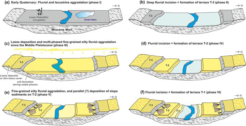
148 A. Khosravichenar et al.: A first outline of the Quaternary landscape evolution of the Kashaf Rud River basin
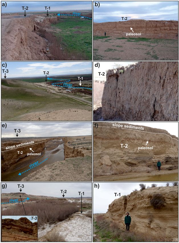
Figure 3. (a, b) Site KR-1 (36◦ 140 1.3200 N, 59◦ 550 32.0400 E) shows the two mainly silty terrace levels T-1 and T-2, with at least one weak
paleosol in the sediments of T-2 (b). (c, d) Site KR-2 (36◦ 100 34.6000 N, 60◦ 40 3.4500 E) shows the two mainly silty terrace levels T-1 and T-2
and terrace level T-3. In level T-2, the fluvial layers are still easily visible (d). (e, f) Site KR-3 (36◦ 100 34.6000 N, 60◦ 40 3.4500 E) shows the
mainly silty terrace level T-2. Anthropogenic activity diverted the river bed some 100 m towards the north, where it forms a steep 7–9 m deep
canyon today. Here, the fluvial sediments of T-2 show a well-developed paleosol and are overlain by up to > 1 m thick gravelly to silty slope
sediments. (g, h) Site KR-4 (36◦ 40 33.3500 N, 60◦ 180 39.6300 E) shows the two mainly silty terrace levels T-1 and T-2 and the gravelly to silty
level T-3. The fluvial layers are still easily visible in T-1 (h). The inset in panel (g) shows the detail of the sediments in level T-3.
iii. Multi-phased fluvial aggradation of level T-2 (Fig. 4c). 2009). Consequently, we suggest that level T-2 has been
The dominance of yellowish to ochreous loamy to silty deposited since that time. During certain periods, the
sediments suggests that they mainly originate from eo- loess deposits in the river basin must have been strongly
lian loess that is found in the catchment today (Fig. 1) reworked by fluvial processes so that they were accu-
and shows similar grain sizes and colors (Karimi et al., mulated as fluvial sediments in the main river valley.
2011; Lauer et al., 2017). Loess deposition in north- Accordingly, Karimi et al. (2011) observed Late Pleis-
ern Iran is known since the Middle Pleistocene (Kehl, tocene periods of strong fluvial reworking of loess de-
E&G Quaternary Sci. J., 70, 145–150, 2021 https://doi.org/10.5194/egqsj-70-145-2021A. Khosravichenar et al.: A first outline of the Quaternary landscape evolution of the Kashaf Rud River basin 149
Figure 4. Compiled Quaternary landscape evolution of the Kashaf Rud River basin.
posits in the southwestern part of the Kashaf Rud River geomorphic changes in the basin during the Quaternary. Be-
basin. At sites KR-1 and KR-3, at least one paleosol sides long-term environmental changes, these were possibly
was observed in the sediments of level T-2. Therefore, also linked with reactions of the river system towards rel-
aggradation must have encompassed different phases atively rapid Late Pleistocene and Holocene global climate
that were interrupted by at least one period of flood- changes (Macklin and Lewin, 2008). In this context, it re-
plain stability with soil formation (von Suchodoletz et mains an open question how far such processes influenced
al., 2018). human migrations and activities in human migration corri-
dor C (Fig. 1).
iv. Fluvial incision of T-2 (Fig. 4d). Given that following
Generally, our field-based results demonstrate the high po-
level T-1 was aggraded at least from the current river
tential of the well-outcropped sediments in the Kashaf Rud
bed, the incision reached down at least to this level.
River basin as archives for Late Quaternary geomorphic and
v. Fluvial aggradation of level T-1, and coverage of level linked paleoenvironmental changes in the drylands of eastern
T-2 by slope deposits (Fig. 4e). Similar to level T- and northeastern Iran that must also have influenced human
2, in level T-1 mostly yellowish to ochreous loamy migrations and activities in this region. Specifically, given
to silty loess-borne sediments were aggraded. Further- the high silt content of terrace levels T-1 and T-2, these
more, a strong erosional landscape dynamic is indicated potentially form complementary sediment archives to for-
by slope deposits that cover the fluvial sediments of merly studied regional loess–paleosol sequences (Karimi et
level T-2 at site KR-3 (Fig. 3e, f). Based on our current al., 2011; Lauer et al., 2017); that is, in case of erosion of
knowledge, it is not clear whether these two processes the loess, corresponding fluvial sediments should have been
were concomitant. deposited in the Kashaf Rud River valley. Therefore, more
detailed studies of the sediments in the Kashaf Rud river
vi. Fluvial incision of level T-1 (Fig. 4f). This incision
basin, using analytical methods, such as numerical dating and
formed the current river bed.
paleoecological analyses, are necessary to contribute to ge-
Terrace levels T-1–T-3 are just morphological forms, so omorphological, paleoenvironmental, and geoarcheological
similar levels in different parts of the valley could poten- research, filling a significant knowledge gap in this largely
tially have been aggraded during different phases (von Su- unexplored region.
chodoletz et al., 2015; Kolb et al., 2016). Therefore, the Qua-
ternary evolution of the Kashaf Rud River basin must have
been much more complex than outlined here. However, al- Data availability. No data sets were used in this article.
ready our first field-based findings demonstrate significant
https://doi.org/10.5194/egqsj-70-145-2021 E&G Quaternary Sci. J., 70, 145–150, 2021150 A. Khosravichenar et al.: A first outline of the Quaternary landscape evolution of the Kashaf Rud River basin
Author contributions. AzK, MF and HvS planned and carried Kehl, M.: Quaternary climate change in Iran –
out the fieldwork. AlK contributed to the information on regional the state of knowledge, Erdkunde, 63, 1–17,
loess and HFN on regional archaeology. https://doi.org/10.3112/erdkunde.2009.01.01, 2009.
Khosravichenar, A., Fattahi, M., Amini, H., and von Suchodoletz,
H.: The potential of small mountain river systems for paleoen-
Competing interests. The authors declare that they have no con- vironmental reconstructions in drylands – an example from the
flict of interest. Binaloud Mountains in northeastern Iran, Geosciences, 10, 448,
https://doi.org/10.3390/geosciences10110448, 2020.
Kolb, T., Fuchs, M., and Zöller, L.: Deciphering fluvial landscape
Acknowledgements. We thank Mohamed Fatemi (Mashhad), evolution by luminescence dating of river terrace formation: A
Ulrich Göres (Dresden) and Klaus von Suchodoletz (Ballwitz) for case study from Northern Bavaria, Germany, Suppl., Z. Geomor-
their help during fieldwork. phol., 60, 29–48, 2016.
Lauer, T., Vlaminck, S., Frechen, M., Rolf, C., Kehl, M., Shar-
ifi, J., Lehndorff, E., and Khormali, F.: The Agh Band loess-
paleosol sequence – A terrestrial archive for climatic shifts
Financial support. The article processing charges for this open-
during the last and penultimate glacial-interglacial cycles in
access publication were covered by the Max Planck Society.
a semiarid region in northern Iran, Quat. Int., 429, 13–30,
https://doi.org/10.1016/j.quaint.2016.01.062, 2017.
Macklin, M. G. and Lewin, J.: Alluvial responses to the chang-
Review statement. This paper was edited by Julia Meister and ing Earth system, Earth Surf. Proc. Land., 33, 1374–1395,
reviewed by one anonymous referee. https://doi.org/10.1002/esp.1714, 2008.
Vahdati Nasab, H., Clark, G. A., and Torkamandi, S.: Late Pleis-
tocene dispersal corridors across the Iranian Plateau: A case
References study from Mirak, a Middle Paleolithic site on the northern edge
of the Iranian Central desert (Dasht-e Kavir), Quat. Int., 300,
Amiri, M. J. and Eslamian, S. S.: Investigation of climate change in 267–281, https://doi.org/10.1016/j.quaint.2012.11.028, 2013.
Iran, Journal of Environmental Science and Technology, 3, 208– von Suchodoletz, H., Menz, M., Kühn, P., Sukhishvili, L., and
216, 2010. Faust, D.: Fluvial sediments of the Algeti River in southeast-
Ariai, A. and Thibault, C.: Nouvelles precisions a propos de ern Georgia - An archive of Late Quaternary landscape activity
l’outillage paléolithique ancient sur galets du Khorassan (Iran), and stability in the Transcaucasian region, Catena, 130, 95–107,
Paléorient, 3, 101–108, 1975. https://doi.org/10.1016/j.catena.2014.06.019, 2015.
Fattahi, M. and Walker, R.: Optical dating of Holocene lake bed von Suchodoletz, H., Zielhofer, C., Hoth, S., Umlauft, J.,
sediments of the Nimbluk Plain, Khorasan, Northeast Iran: Im- Schneider, B., Zeeden, C., Sukhishvili, L., and Faust,
plications for the climate change and palaeoenvironment, Journal D.: North Atlantic influence on Holocene flooding in
of the Earth and Space Physics, 41, 1–12, 2016. the southern Greater Caucasus, Holocene, 28, 254–269,
Faust, D. and Wolf, D.: Interpreting drivers of change https://doi.org/10.1177/0959683617735584, 2018.
in fluvial archives of the Western Mediterranean Walker, R. T. and Fattahi, M.: A framework of Holocene and Late
– A critical view, Earth-Sci. Rev., 174, 53–83, Pleistocene environmental change in eastern Iran inferred from
https://doi.org/10.1016/j.earscirev.2017.09.011, 2017. the dating of periods of alluvial fan abandonment, river ter-
Jamialahmadi, M., Vahdati Nasab, H., Fazeli Nashli, H., and racing, and lake deposition, Quat. Sci. Rev., 30, 1256–1271,
Beshkani, A.: Kashafrud revisited: discovery of new Palaeolithic https://doi.org/10.1016/j.quascirev.2011.03.004, 2011.
sites in north-eastern Iran. Antiquity 82, project gallery, avail-
able at: http://www.antiquity.ac.uk/projgall/nasab317 (last ac-
cess: 10 February 2021), 2008.
Karimi, A., Frechen, M., Khademi, H., Kehl, M., and Jalalian,
A.: Chronostratigraphy of loess deposits in northeast Iran, Quat.
Int., 234, 124–132, https://doi.org/10.1016/j.quaint.2009.08.002,
2011.
E&G Quaternary Sci. J., 70, 145–150, 2021 https://doi.org/10.5194/egqsj-70-145-2021You can also read