A stream sediment geochemical survey of the Ganga River headwaters in the Garhwal Himalaya
←
→
Page content transcription
If your browser does not render page correctly, please read the page content below

Geochemical Journal, Vol. 41, pp. 83 to 95, 2007

       A stream sediment geochemical survey of the Ganga River headwaters
                            in the Garhwal Himalaya

          P. K. M UKHERJEE,1* K. K. PUROHIT ,1 N. K. S AINI,1 P. P. KHANNA,1 M. S. RATHI 1 and A. E. G ROSZ2
                              1
                                  Wadia Institute of Himalayan Geology, 33 GMS Road, Dehradun, India
                                           2
                                             U.S. Geological Survey, Reston, Virginia, U.S.A.

                                         (Received June 24, 2006; Accepted October 31, 2006)

        This study models geochemical and adjunct geologic data to define provinces that are favorable for radioactive-min-
    eral exploration. A multi-element bed-sediment geochemical survey of streams was carried out in the headwaters region of
    the Ganga River in northern India. Overall median values for uranium and thorium (3.6 and 13.8 ppm; maxima of 4.8 and
    19.0 ppm and minima of 3.1 and 12.3 ppm respectively) exceed average upper crustal abundances (2.8 and 10.7 ppm) for
    these radioactive elements. Anomalously high values reach up to 8.3 and 30.1 ppm in thrust zone rocks, and 11.4 and 22.5
    ppm in porphyroids. At their maxima, these abundances are nearly four- and three-fold (respectively) enriched in com-
    parison to average crustal abundances for these rock types. Deformed, metamorphosed and sheared rocks are characteris-
    tic of the main central thrust zone (MCTZ). These intensively mylonitized rocks override and juxtapose porphyritic (PH)
    and proterozoic metasedimentary rock sequences (PMS) to the south. Granitoid rocks, the major protoliths for mylonites,
    as well as metamorphosed rocks in the MCT zone are naturally enriched in radioelements; high values associated with
    sheared and mylonitized zones are coincident with reports of radioelement mineralization and with anomalous radon
    concentrations in soils. The radioelement abundance as well as REE abundance shows a northward enrichment trend
    consistent with increasing grade of metamorphism indicating deformation-induced remobilization of these elements. U
    and Th illustrate good correlation with REEs but not with Zr. This implies that zircon is not a principal carrier of U and Th
    within the granitoid-dominant thrust zone and that other radioelement-rich secondary minerals are present in considerable
    amounts. Thus, the relatively flat, less fractionated, HREE trend is also not entirely controlled by zircon. The spatial
    correlation of geologic boundary zones (faults, sheared zones) with geochemical and with geophysical (Rn) anomalies
    infers ore mineralization by hydrothermal processes generated during multiple episodes of deformation and thrusting. The
    geologic setting of the anomalies also suggests that crystalline rocks (MCT Zone) along the nearly 2500 km length of the
    LesserHimalayan belt, where in the vicinity of thrust and fault zones, have potential for radioelement mineralization.
    Zones of higher concentrations of radioelements delineated by this study and locations of anomalous radon discharge
    determined by other investigations may indicate a potential health hazard over the long term. However, the low human
    population density precludes direct manifestation of health effects attributable to chronic exposure to these radioelements;
    however, the magnitude of natural concentrations suggests the need for more detailed studies and monitoring.

                  Keywords: geochemistry, radioelement, mineralization, uranium, thorium, radon, Himalayas, thrust zones

                                                                        commonly by chemical analyses of stream-drainage
                        INTRODUCTION
                                                                        sediments and of soil samples. Considering the terrain
   Geochemical data, in combination with mineralogic                    characteristics in Himalayan region, sediments in a stream
and other adjunct data sets such as geologic maps, air-                 contain elements derived from the surrounding watershed
borne gamma-ray surveys, mineral deposit distribution,                  and their composition is more representative of the
among others, provides the foundation for classifying and               geochemical characteristics of the area than other less
evaluating mineral-resource endowment and natural haz-                  easily available sampling media such as soil, plant and
ards. When exposed at, or near the surface of the earth,                groundwater. Rainfall and weathering are more extensive
mineral resources produce diagnostic textural, geologic,                and hence sediment yield is very high in streams of local
geophysical, and geochemical signatures. Geochemical                    extent. The Ganga river headwater region is a wide moun-
exploration is based on outlining such dispersion halos,                tainous drainage network from which the vast downstream
                                                                        floodplain (gangatic plains) receives input from a series
                                                                        of variously-sized tributaries. The study area covers wa-
                                                                        tersheds of its four main tributaries from west to east—
*Corresponding author (e-mail: mukherjee_pk@wihg.res.in)
                                                                        Bhagirathi, Bhilangana, Mandakini and Alaknanda
Copyright © 2007 by The Geochemical Society of Japan.                   (Fig. 1).

                                                                   83
Fig. 1. Map of the Ganga river headwaters region showing locations of stream sediment samples (open circles), localities
referred to in the text (filled circles). The dotted boundary delimits the area shown on the geochemical maps in Figs. 3–6.

    The area of our study is remote and poorly accessi-        cern when spatially associated with human community.
ble; therefore it has a poorly developed infrastructure. As    Therefore concerns for the effect of these radioactive el-
this region is fast-growing in population and is part of a     ements on the environment and human health have in-
newly created state in India, we think it important to as-     creased in the last few decades (Lima et al., 2005).
sess the nature and extent of the zones that are potential         Radioactive mineralization in the study area has been
at high risk from radioactive exposure. Such information       reported by Negi (1967), Das et al. (1981), Nashine et al.
is needed for policy makers to provide sound basis for         (1982) and Udas (1986). In Bhilangana valley near
addressing public concern regarding high natural radio-        Budhakedar, uraninite, pitchblende, brannerite and flu-
activity in some specific areas. Anomalous radioelement        orapatite have been identified and occur in lenticular
concentrations shown by geochemical data and by adjunct        quartz veins containing radiometric assay values of
geophysical (Rn), geologic, and mineral occurrence data        mylonitized granitic gneisses of the order of 380 to 6600
provide a regional structural and geologic context for the     ppm U2O3 and about 50 ppm ThO2. The Atomic Mineral
nature and possible extent of mineralization.                  Division (Govt. of India) has also reported several oc-
    Potassium (K), uranium (U), and thorium (Th) are the       currences of pitchblende and uraninite as well as their
principal radioactive elements (henceforth, radioelements)     secondary weathered products along the 50–80 km stretch
in terrestrial materials. These radioelements occur in a       of the Thrust Zone between Uttarkashi and Chamoli
wide variety of minerals in various combinations, com-         (Bhattacharya, 1989; Kaul et al., 1991). Boltwoodite, a
monly as phosphates (monazite), silicates (zircon), and        hydrated alkali uranyl silicate, has also been identified
as oxides (uraninite). Daughter products of the U and Th       by Singh et al. (1991) to occur as secondary precipitates
decay-series include radon (Rn) and radium (Ra) whose          associated with uraninite-bearing quartz veinlets near
presence and relative abundance has implications for ex-       Brijranigad in the Bhilangana valley. Thus, there are wide-
posure-related health hazards. Where host minerals oc-         spread indications of radioactive mineralization all along
cur in unusually high concentration (mineralization; not       the Thrust Zone. The mineralization is sporadically dis-
necessarily a mineral deposit), Rn may be of serious con-      tributed and may not be commercially viable.

84   P. K. Mukherjee et al.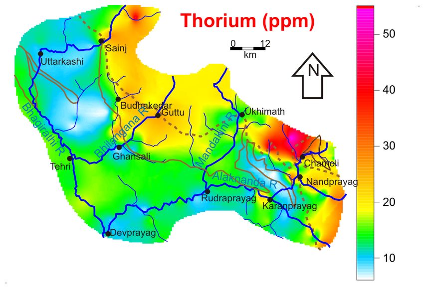
Unusually high discharge of radon was noted by                  The Lesser Himalayan terrain is simplified into three
Choubey and Ramola (1997) and Choubey et al. (1999)             major litho-tectonic units in the study area. Each is
in soils and in spring waters in the study area. Radon          bounded generally by northwest-southeast trending re-
emissions, varying from 1 to 57 KBq/M3 in soils and from        gional tectonic contacts with a gentle northerly dip that
less than 5 to 887 Bq/L in spring water within the area of      is locally variable. These are, from north to south: 1) the
our study confirm the high anomalies observed by                Main Central Thrust Zone (MCTZ, Metcalfe, 1993) that
Choubey and Ramola (1997) that are described as con-            includes Valdiya’s Munsiari, Baijnath, and Almora groups;
trolled by geological factors, especially around the thrust     Fig. 2) the Porphyroids (PH) that include Valdiya’s
zone. The radon content of the Balganga (a tributary of         Debguru formation of Ramgarh Group; and 3) a
Bhilangana) river water is also surprisingly high (26.2         Proterozoic metasedimentary sequence (PMS) that in-
Bq/l near Budhakadar to 0.1 Bq/L near Ghanshali;                cludes Valdiya’s Gangolihat, Rautgara, and Berinag for-
Choubey et al., 2000). Moreover, radioactive minerali-          mations (also referred to as Garhwal Group). The PMS
zation in this area has also been reported at some of the       of the Lesser Himalayan terrain is overridden by the crys-
high Rn locations (Negi 1967; Nashine et al., 1982; Das         talline nappes (MCTZ and PH) including higher
et al., 1981; Bhattacharya, 1989; Kaul et al., 1991).           Himalayan crystallines (HHC) uprooted from the north.
    Reports of base metal sulphide mineralizations have             The rocks of the MCTZ are characterized by highly
also been reported from a number of locations in the stud-      deformed, sheared, mylonitized and metamorphosed
ied area as well as in the adjacent regions (Kumar, 1970;       schists, gneisses, mylonites and migmatites having mainly
Valdiya, 1980; Dutta and Ghose, 1970; Ghose et al.,             granitic parentage with minor imbricated foliated quartz-
1986). Moreover, the area has also witnessed substantial        ite, calc-silicates and components of probable pelitic
mining activities in the past (Walton, 1910), but mostly        sedimentaries. Below the MCTZ, multiple tectonic scales
for base metals only. Such evidence of extensive hydro-         or schuppen structure is developed particularly between
thermal activity may or may not be related to Himalayan         the Mandakini and Alaknanda rivers. PH is comprised of
orogeny. In spite of the fact that radioactive mineraliza-      profoundly mylonitized and sheared suite of porphyritic
tion (as well as base metal sulphide mineralization) in         granite-granodiorite-quartz porphyry intruded into the
this area has been reported from a number of locations          phyllites interbedded with quartzite and minor carbon-
and radon emanations observed at places are abnormally          ates. The PMS consists of a sequence of quartzites, car-
high, no comprehensive attempt has been made to assess          bonate rocks and phyllites together with considerable
the mineral potential of the area. It is therefore important    amount of pene-contemporaneous metavolcanics of the
to know the geochemical dispersion of the radioelements         Lesser Himalaya (the Garhwal Group).
and the relationship of this distribution to the geology of         The discontinuity and abrupt change between the crys-
the area to provide a useful guide for future exploration.      talline rocks of Munsiari, Baijnath or Almora and under-
In this paper, we attempt to document the possible extent       lying Proterozoic metasedimentary sequence was recog-
of radioelement mineralization through a stream sediment        nized as the Main Central Thrust (MCT; Valdiya, 1980).
geochemical survey and resultant geochemical dispersion         Recent workers propose that the MCT is a wide zone of
maps.                                                           high strain ductile shear corresponding to the entire thick-
                                                                ness of Munsiari/Baijnath/Almora crystalline rocks, as-
                                                                sociated with inverted metamorphism from south to north
                   GEOLOGIC SETTING
                                                                with increasing structural height rather than a single thrust
    The area is situated in the Garhwal Himalaya region         plane as perceived earlier (Valdiya et al., 1999, Metcalfe,
(Fig. 1) of India. It represents a boundary zone where          1993). We also prefer to refer to this as the Main Central
rocks of differing ages and compositions are juxtaposed         Thrust Zone (MCTZ) for simplicity. The MCTZ thus sepa-
by intensive shearing and displacement associated with          rates the high grade HHC rocks to the north by Vaikrita
structural thrusts. The area studied is drained by, the         (roof) thrust (VT) and the low-grade Lesser Himalayan
Alaknanda, Mandakini, Bhilangana and Bhagirathi Riv-            thrust sheets (PMS) by Munsiari (floor) thrust (MT) or
ers (Fig. 1). The structural and tectonic intricacy of          its equivalents (Baijnath thrust—“BT” and Almora
Himalaya has been the subject of many studies notably           thrust—“AT”; Fig. 2). The MCTZ at the base is under-
by Kumar and Agarwal (1975), Valdiya (1980) Thakur              lain by PH with a thrust contact (MT, BT or AT) and at
and Rawat (1992), and Valdiya et al. (1999). It is beyond       places thrust directly over the Proterozoic meta-sedimen-
the scope of this study to review and synthesize the geo-       tary sequence (PMS). The PH in turn is thrust over the
logic mapping and structural interpretation for the area        PMS to the south and is separated by “Ramgarh thrust”
at a large scale given the small size of the area. We present   (RT). A simplified schematic N-S section of the area is
a simplified geologic base modified and adapted from            shown in Fig. 2B for clarity.
Valdiya’s (1980) in Fig. 2.                                         The grade of metamorphism in general increases with

                                                                             Geochemical survey in Ganga headwaters       85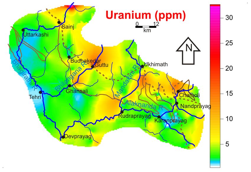
Fig. 2. [A] Simplified geologic map of the study area (after Valdiya, 1980). Lithotectonic units are separated by major thrusts.
Almora thrust (AT) and Baijnath thrust (BT) is different local names for the Munsiari thrust (MT) used in literature. [B] A
schematic north-south structural cross-section through the center of the area.

86   P. K. Mukherjee et al.
increasing structural height from south to north (Sachan       BCS-267 (Govindaraju, 1994). Evaluation of reproduc-
et al., 2001). Locally, however, there is retrogradation due   ibility, accuracy and minimum detection limit were car-
to shearing involving extensive fluid activity in the shear    ried out in a similar way as outlined in Saini et al. (2002).
zone. The sedimentary rocks (PMS) are metamorphosed            The accuracy of measurements is better than 12% for U,
to chlorite grade, whereas the PH demonstrate biotite          Th, and Zr and
Table 1. Summary statistics of the abundance of U, Th, Zr and K 2O in the three
                      lithotectonic units and as a whole. The median value denotes the baseline concen-
                      tration. The ranges of concentration of the elements are represented by the 10th
                      and 90th percentile value. Standard deviation on average (Sd) are given in paren-
                      thesis.

                                                               Th           U            Zr         K2 O

                       MCTZ (Crystalline) (N = 48)
                        Median                             19.0           4.8         281         2.2
                        Average (Sd)                       21.0 (10.1)    5.9 (5.3)   334 (163)   2.3 (1.18)
                        10th_Percentile                    11.2           1.6         191         0.9
                        90th_Percentile                    30.8           8.3         513         3.6

                       PH (Porphyroids) (N = 49)
                        Median                             14.2           3.7         274         2.6
                        Average (Sd)                       15.6 (6.4)     5.8 (4.0)   284 (89)    2.7 (1.09)
                        10th_Percentile                    10.6           2.1         181         1.5
                        90th_Percentile                    22.5          11.4         410         4.0

                       PMS (Proterozoic metasedimentary) (N = 85)
                         Median                            12.3           3.1         294         2.2
                         Average (Sd)                      12.7 (4.8)     3.3 (1.9)   300 (94)    2.2 (0.86)
                         10th_Percentile                    8.2           1.3         186         1.2
                         90th_Percentile                   16.3           5.2         398         3.4

                       All samples (N = 182)
                        Median                             13.8           3.6         288         2.3
                        Average (Sd)                       15.7 (7.7)     4.7 (3.9)   304 (116)   2.3 (1.03)
                        10th_Percentile                     6.5           0.5         135         0.5
                        90th_Percentile                    23.6           8.9         422         3.6
                        AUCA                               10.7           2.8         190         3.4

U and 19 ppm Th and for PH; 3.7 and 14.2 ppm, respec-               minor metasedimentary components, but the same unit
tively. PMS rocks are least enriched in U and Th (3.2 and           25 km to the west in the Bhagirathi valley consists mainly
12.4 ppm). Gradual southward decreases in the median                of metasedimentary rocks and the granitic- and
values of the U and Th from the MCTZ through PH and                 granodioritic-rock component of PH in this part is present
PMS correspond to decreases in grade of metamorphism.               to the northwest; outside of the sampling area of this study.
The inference is that elemental mobility and secondary              The U and Th variation maps (Figs. 3 and 4) correlate
enrichment are largely driven and controlled by fluid-rock          reasonably well with each other except for the fact that
interaction during deformation and metamorphism. This               the dispersion of U is more extensive as compared to Th
trend is also consistent with the average REE abundance             and the maxima for U and Th do not match exactly, indi-
(Fig. 8(b)). The range of concentration (as 10th and 90th           cating decoupling of U and Th in their dispersion and
percentile values) for Th are consistent with the above             differential mobility. This decoupling may be due to the
observation, but U reaches higher values in PH rocks,               fact that U is readily soluble in its 6+ natural oxidizing
lower in MCTZ rocks, and least in PMS rocks (Table 1).              state (forms uranyl complex) and is dispersed in aqueous
Baseline values are thus marginally higher in compari-              solution quite easily. On the other hand, Th is sparingly
son to those of AUCA. Some samples from the MCTZ                    soluble in aqueous medium in its 6+ state, though Th4+ is
and the PH from the central and eastern parts show con-             soluble to some extent but is not stable and precipitates
centrations up to 34 ppm U and 57 ppm Th.                           immediately. Thus, U shows more diffused aureoles
    The spatial variations in the distribution of elements          around the mineralized zones and also shows some sec-
shown in Figs. 3–6 reflect underlying geologic charac-              ondary enrichment anomalies. Isolated patches of high U
teristics. It is important to consider that at the scale of         and Th values are observed all along the MCTZ as well
our work we are using groupings of differing rock-types             as part of PH in Bhilangana valley in the north and in
whose compositions vary spatially. For example, the PH              eastern part with more intense maxima occurring close to
along the Bhilangana River (in the central part of the study        thrust planes. The zirconium variation pattern (Fig. 6)
area) is composed of granitic or granodioritic rocks with           shows more random dispersion with very little spatial

88   P. K. Mukherjee et al.
Fig. 3. Geochemical map showing the distribution of uranium. The solid lines is the trace of the Bhatwari thrust (BT) demarcat-
ing PMS and PH; dashed lines represents the Munsiari thrust (MT) demarcating MCTZ and PH. Sampling points are shown as
open circles and major rivers are shown in blue lines.
Fig. 4. Geochemical map showing the distribution of thorium. For Legend explanation see Fig. 3 caption.
correlation with those of U and Th. The distribution of Zones of higher K2O concentrations correspond to the
potassium (Fig. 5), in contrast, shows high values mainly granitoid out crops within the PH and granitic gneisses
in PH and, less frequently, on MCTZ and PMS rocks ex- in the MCTZ. Relative abundances of granitoid versus
cept for the one near Tehri where phyllitic rocks prevail. metasedimentary components in PH are well illustrated
Geochemical survey in Ganga headwaters 89Fig. 5. Geochemical map showing the distribution of potassium (as wt% oxide). For Legend explanation see Fig. 3 caption.
Fig. 6. Geochemical map showing the distribution of zirconium. For Legend explanation see Fig. 3 caption.
by the K2O distribution pattern (Fig. 5). We, therefore, The host mineral of U and Th
infer that distribution patterns shown by U and Th are Many of the high-value samples cluster near MT and
neither fully controlled by the abundance of zircon nor BT thrust contacts; values reach up to 34 ppm U and 135
by the radiogenic granitoids; rather they seem to be con- ppm Th, indicating potential for mineralization. In most
trolled by secondary mineralization. This makes probable rock types where zircon occurs, it is a significant host for
the occurrence of ore-grade mineralization. rare-earth elements, Th, and U (Finch and Hanchar, 2003).
90 P. K. Mukherjee et al.Table 2. Average REE abundance (in ppm)
of the three Lithotectonic units (n = number
of samples averaged)
PMS PH MCTZ
(N = 10) (N = 5) (N = 13)
La 30.2 40.5 86.1
Ce 61.6 87.1 195.2
Nd 26.8 28.2 46.0
Sm 5.59 6.52 12.23
Eu 1.40 1.41 1.86
Gd 4.39 5.40 9.87
Tb 0.75 0.93 1.68
Dy 4.11 5.27 9.45
Ho 0.80 1.05 1.88
Er 2.32 3.07 5.77
Tm 0.32 0.42 0.85 Fig. 7. Binary plot of zirconium and sum of U and Th for all
Yb 1.84 2.38 5.05 the samples excluding outliers defined by 10th and 90th per-
Lu 0.27 0.34 0.77 centile values. The data from different lithotectonic unites are
Tot. REE 140.4 182.6 376.6 plotted with different symbols for clarity.
Zircon is a common accessory mineral in acid magmatic natures of MCTZ and PH in Ganga average bed-
rocks like granitoids and has very high partitioning coef- sediments. Thus the average Yamuna sediments are more
ficients for REEs, U and Th (Finch and Hanchar, 2003). enriched in REE abundances. The less fractionated flat
Since the MCTZ and PH are comprised primarily of meta- HREE pattern is typical of zircon, but some ores of U
morphosed and strongly sheared granitoids in this area, and Th (e.g., secondary oxides and phosphates like thorite,
the control of zircon on the abundance of high U, Th and uraninite, monazite, apatite, pitchblende etc.) can also
REEs needs to be ascertained. In a few well-sorted high- produce the same effect having high partition coefficient
order river bar sediments, abnormally high U (81 ppm) for REEs especially more for HREEs and MREEs. Oc-
and Th (135 ppm) were associated (high-order River data currence of these vein-hosted minerals in the study area
not included here) with high Zr (4413 ppm) in a sample has also been reported by, many workers (Bhattacharya,
from the Bhagirathi River. Another sample from the 1989; Kaul et al., 1991; Singh et al., 1991). Relatively
Alaknanda River having comparable Zr (4084 ppm) but high dissolved REE abundance observed in Ganga and
has lower U (32 ppm) and much higher Th (365 ppm). Yamuna river water samples (Rengarajan and Sarin, 2004)
There are several individual samples, both from high or- may also be due to partial contributions from dissolution
der rivers and low order stream sediment samples that of these secondary minerals that are relatively less resist-
show departure from the projected correlation of U and ant to weathering compared to zircon. The plot of U+Th
Th with Zr, if zircon were the principal radioelement car- versus Zr in MCTZ (Fig. 7) shows more scatter in com-
rier. A few sediment samples from all three lithotectonic parison to that of U+Th versus REEs (Fig. 8a). This clearly
units were also analyzed for their REE abundance (Table suggests less influence and control of zircon abundance
2) in order to compare the REE geochemistry of the in the source region. Notable mobility in REEs and prob-
lithotectonic units. The chondrite-normalized REE pat- ably U and Th as well, has been observed in tectono-ther-
terns (Fig. 8(b)) for the MCTZ samples are distinctly more mal processes such as shearing, where mechanical grind-
enriched than PMS samples with PH samples fall inter- ing and grain size reduction is accompanied under poten-
mediate between the two. Moreover, the MCTZ shows tially high fluid activity (Dostal et al., 1980; Winchester
more flat HREE trend than LREEs with prominent mag- and Max, 1984; Vocke et al., 1987; Grauch, 1989; Roland
nitude of Eu anomaly. The Eu anomaly in case of the et al., 2003 and others). This would mean that REEs, U,
stream sediment samples from the PMS is very feeble and and Th have been remobilized and concentrated into the
that of PH are intermediate. The REE trends of MCTZ fluid phase during the shearing and might have been em-
and PH are also more akin to the average Ganga and placed as veins at a shallower depth along the fluid chan-
Yamuna River bed sediments (Fig. 8(b)) as reported by nels (thrust contacts). Zones of intense deformation and
Rengarajan and Sarin (2004). Ganga catchment area be- shearing in the MCTZ and PH become more porous and
ing more laterally spread within PMS terrain compared provide pathways for fluid channeling (Selverstone et al.,
to narrow catchment of Yamuna, the influence of PMS 1991; Essaifi et al., 2004; Keller et al., 2004; and refer-
on Ganga sediments is more prevalent that dilutes the sig- ences therein) and their precipitation as ore minerals.
Geochemical survey in Ganga headwaters 91(b) (a) Fig. 8. (a) Binary plot of total REEs with U+Th using a limited number of representative samples from each lithotectonic unites. (b) Chondrite normalized REE plot of the average compositions of the each lithotectonic unit. Average Ganga and Yamuna sediments data are from Rengarajan and Sarin (2004). Fig. 9. Soil-gas radon concentration (in KBq/M3) at selected sites is shown as proportional plot (data after Choubey et al., 1999). The lithotectonic outlines are same as in Fig. 2. 92 P. K. Mukherjee et al.
Radioactive anomaly zones                                      genesis to the presence of secondary U and Th rich ore
    Several independent lines of evidence imply that zones     minerals in MCTZ that are expectedly rich in REEs.
of U and Th ore mineralization are present in shear zones      Anomalous radon values reported by others are consist-
within and near crystalline rocks of MCTZ and PH. In           ent with, and predicted by our geochemical study. The
areas bounded by crystalline rocks to the north, the           MCTZ, and to a lesser extent PH are prospective for
geochemical maps for U (Fig. 3) and Th (Fig. 4) show           radioelement mineralization and geochemical maps are a
isolated patches of enrichment and correspond well with        powerful guide for future exploration. Because of the
Rn anomalies (Fig. 9). Considering areas with >5 ppm U         structural controls on the anomalies and related tectonic
and >15 ppm Th as threshold (Ewers, 1991), more than           processes, the crystalline rocks along the entire length
60% of the MCTZ and PH terrain are favorable zones for         (~2500 km) of the Lesser Himalayan belt probably have
exploration. These are located within the MCTZ (N of           some potential for radioelement mineralization.
Nandprayag, E of Ukhimath, near Ghuttu and Budhakedar
and E-NE of Sainj) and within PH in Bhilangna valley.          Acknowledgments—This work was carried out under the thrust
The rocks are extensively mylonitized, and complexly           area projects of the Wadia Institute of Himalayan Geology,
thrust. We conclude that mineralization in this area is        Dehradun. B. R. Arora is thankfully acknowledged for encour-
linked to deformation-induced radioelement                     agement and support. We thank Joseph S. Duval (USGS, Reston)
                                                               and C. Reimann for comments on an earlier draft of this manu-
remobilization and subsequent emplacement as veins. We
                                                               script. The work benefited from discussions with the members
model potential for uranium in vein and disseminated
                                                               of the FOREGS and IUGS group on global geochemical base-
mineralization in lower Himalaya crystalline rocks             lines.
(MCTZ and PH) and predominantly occurring within the
hanging wall rocks immediately overlying the thrusts
planes. We speculate that the areas of relatively high                                 REFERENCES
radioelement abundance together with high Radon ema-           Armour-Brown, A. and Nichol, I. (1970) Regional geochemical
nation may be detrimental to livestock. However, conse-           reconnaissance and the location of metallogenic provinces.
quences of U, Th and Rn exposure are not apparent in              Econ. Geol. 65, 312–330.
permanent residents, as the population density of the area     Bhattacharya, A. K. (1989) Uranium mineralization at
is currently low.                                                 Brijranigad along Main Central Thrust, Garhwal Himalaya,
                                                                  Tehri district, Uttarpradesh, India. Exploration and Research
                                                                  for atomic minerals (Atomic Mineral Div. DAE) Vol. 2 (ab-
                      CONCLUSIONS                                 stract).
                                                               Choubey, V. M. and Ramola, R. C. (1997) Correlation between
    The geochemical spatial variation map provides an
                                                                  geology and radon levels in groundwater, soil and indoor
indication of the zones that have potential for minerali-
                                                                  air in Bhilangna valley, Garhwal Himalaya, India. Environ.
zation. Our study shows U and Th are more enriched in             Geol. 32(4), 258–262.
Lesser Himalayan Crystalline (mostly MCTZ and less             Choubey, V. M., Bist, K. S., Saini, N. K. and Ramola, R. C.
prominently PH) rocks than in PMS rocks. Median val-              (1999) Relation between soil-gas radon variation and the
ues of radioelements in the context of crustal averages           different lithotectonic units of Garhwal Himalaya, India.
(AUCA) and of common rock-type averages are higher.               Jour. Applied Radiation and Isotopes 51(5), 587–592.
REEs are also more enriched (~2-fold) with a flat HREE         Choubey, V. M., Bartarya, S. K. and Ramola, R. C. (2000) Ra-
pattern in MCTZ compared to that of PMS; PH shows                 don in Himalayan springs: A geohydrological control.
intermediate enrichment. This is also consistent with             Environ. Geol. 39(6), 523–530.
northward increase in grade of metamorphism. We infer          Darnley, A. G., Bjorklund, A., Bolviken, B., Gustavsson, N.,
                                                                  Koval, P. V., Plant, J. A., Steenfelt, A., Tauchid, M. and
these systematic variations to be controlled by and re-
                                                                  Xie, X. (1995) A global geochemical database for environ-
lated to deformation- and metamorphism-induced miner-
                                                                  mental and resource management. Earth Sciences 19, United
alizing fluids derived from radiogenic granitoid sources          Nations Educational, Scientific and Cultural Organisation,
and structurally controlled in the vicinity of thrust zones.      Paris, 122 pp.
U and Th correlate well with the REEs but not with Zr,         Das, G. R., Bhatnagar, G. S., Bhattacharya, A. K. and Sharma,
which suggests anomalies are not entirely controlled by           Y. C. (1981) Uranium in metamorphites around Brijranigad,
abundances of zircons from granitoids. Thus, the removal          Raunsal, Tehri Garhwal (U.P.). Metamorphic Tectonites of
of radioelements as labile forms in fluids followed by            the Himalaya (Saklani, P. S., ed.), 111–122, Today and To-
sequestration in stable ore-minerals emplaced in veins            morrow’s Pub., New Delhi.
along the structurally controlled fluid channels seems to      Dostal, J., Strong, D. F. and Jamieson, R. A. (1980) Trace ele-
be the most likely operative process of secondary enrich-         ment mobility in mylonite zone within the ophiolite aure-
                                                                  ole, St. Anthony complex, Newfoundland. Earth Planet. Sci.
ment. The high dissolved REE abundance in Ganga river
                                                                  Lett. 49, 188–192.
water (Rengarajan and Sarin, 2004) probably heralds its

                                                                             Geochemical survey in Ganga headwaters         93
Dutta, K. K. and Ghose, A. (1970) On the structure and miner- Sileth, Dhargaon, Chamyala Balganga valley, Tehri Garhwal
alization in the Dhanpur area, Chamoli district, U.P. Geol. U.P. Him. Geol. 12, 305–323.
Surv. India, Calcutta, Base metals, Misc. Publication 16(1), Negi, B. S. (1967) Uranium mineralization in Pokhri-Tunji area,
85–92. Chamoli district. Quart. Jour. Geol. Min. Metal Soc. India
Essaifi, A., Capdevila, R., Fourcade, S., Lagarde, J. L., Ballèvre, 39, 93–98.
M. and Marignac, C. H. (2004) Hydrothermal alteration, Oliver, G. J. H., Joshnson, M. R. W. and Fallick, A. E. (1995)
fluid flow and volume change in shear zones: the layered Age of metamorphism in lesser Himalaya and main central
mafic-ultramafic Kettara intrusion (Jebilet Massif, Variscan thrust zone, Garhwal, India: results of illite crystallinity,
40
belt, Morocco). J. Metamorphic. Geol. 22, 25–43. Ar-39Ar fission and K-Ar studies. Geol. Mag. 132, 139–
Ewers, U. (1991) Standards, guidelines and legislative regula- 149.
tions concerning metals and their compounds. Metals and Reimann, C. and Caritat, P. D. (1998) Chemical Elements in
Their Compounds in the Environment (Merian, E., ed.), 760– the Environment. Springer-Verlag, New York.
710, VCH, Weinheim, Germany, 860 pp. Reimann, C., Filzmoserb, P. and Garrettc, R. G. (2005) Back-
Finch, R. J. and Hanchar, J. M. (2003) Structure and chemistry ground and threshold: critical comparison of methods of
of zircon and zircon-group minerals. Reviews in Mineral- determination. Science of the Total Environment 346, 1–
ogy, Vol. 53 (Hanchar, J. M. and Hoskin, P. W. O., eds.), 1– 16.
25. Rengarajan, R. and Sarin, M. M. (2004) Distribution of Rare
Ghose, A. R., Mukherjee, A. and Kothiyal, D. L. (1986) Re- Earth Elements in Yamuna and Chambal rivers, India.
gional geochemical appraisal for exploration of non-ferrous Geochem. J. 38, 551–569.
metal in parts of Uttar Pradesh Himalaya. Geol. Surv. In- Rock, N. M. S. (1988) Numerical Geology. Lecture Notes in
dia, Misc. Publication 41, 111–126. Earth Sciences, 18. Springer-Verlag, Berlin, 427 pp.
Govindaraju, K. (1994) Compilation of working values and Rolland, Y., Cox, S., Boullier, A. M., Pennacchioni, G. and
sample description for 383 geostandards. Geostand. Newsl. Mancktelow, N. (2003) Rare earth and trace element mo-
18 (Special Issue), 1–158. bility in mid-crustal shear zones: insights from the Mont
Grauch, R. I. (1989) Rare earth elements in metamorphic rocks. Blanc Massif (Western Alps) Earth Planet. Sci. Lett. 214,
Geochemistry and Mineralogy of Rare Earth Elements (Lu- Issues 1–2, 203–219.
pin, B. L. and McKay, G. A., eds.), Reviews in Mineralogy Sachan, H. K., Sharma, R., Sahaib, A. and Gururajan, N. S.
21, 147–167. (2001) Fluid events and exhumation history of the main
Kaul, R., Singh, R., Sen, D. B. and Gupta, R. K. (1991) Ura- central thrust zone Garhwal Himalaya (India). Jour. Asian
nium exploration in the Proterozoic rocks of North western Earth Sci. 19, 207–221.
Himalaya, India. Exploration and Research for atomic min- Saini, N. K., Mukherjee, P. K., Rathi, M. S., Khanna, P. P. and
erals (Atomic Mineral Div. DAE) Vol. 4 (abstract). Purohit, K. K. (2002) Trace element estimation in soils: An
Keller, L. M., Abart, R., Stunitz, H. and De Capitani, C. (2004) appraisal of ED-XRF technique using group analysis
Deformation, mass transfer and mineral reaction in an scheme. Jour. of Trace and Microprobe Techniques 20(4),
eclogite facies zone in polymetamorphic metapelite (Monte 539–551.
Rosa nappe, Western Alps). J. Metamorphic Geol. 22, 97– Selverstone, J. Morteani, G. and Staude, J. M. (1991) Fluid
118. channelling during ductile shearing: transformation of
Kumar, G. (1970) Geology and sulphide mineralization in the granodiorite into aluminous schist in the Tauern Window,
Pokhri area, Chamoli district, U.P. Geol. Surv. India, Cal- Eastern Alps. J. Metamorphic Geol. 9, 419–431.
cutta. Base metals, Misc. Publication 16(1), 92–98. Singh, K. D. P., Bhattacharya, A. K. and Murthy, G. V. G. K.
Kumar, G. and Agarwal, G. C. (1975) Geology of the Srinagar- (1991) X-ray diffraction studies of boltwoodite and associ-
Nandprayag area (Alaknanda Valley), Chamoli, Garhwal and ated Uranium minerals from the Proterozoic rocks of
Tehri Garhwal districts, Kumaun Himalaya, Uttar Pradesh. Brijranigad, Tehri district, Uttarpradesh, India. Exploration
Him. Geol. 5, 29–59. and Research for atomic minerals (Atomic Mineral Div.
Lima, A., Albanese, S. and Cicchella, D. (2005) Geochemical DAE) Vol. 4 (abstract).
baselines for the radioelements K, U and Th in the Campania Taylor, S. R. and McLennan, S. M. (1995) The geochemical
region, Italy: a comparison of stream-sediment geochemistry evolution of the continental crust. Rev. Geophys. 33, 241–
and gamma-ray surveys. Jour. Appl. Geochem. 20, 611–625. 265.
Lucas-Tooth, H. J. and Pyne, C. (1964) The accurate determi- Thakur, V. C. and Rawat, B. S. (1992) Geological Map of West-
nation of major constituents by X-ray fluorescence analy- ern Himalaya. Sp. Pub. Wadia Institute of Himalayan Ge-
sis in presence of large inter-element effects. Adv. X-ray ology, 1–22.
Anal. 7, 523–541. Udas, G. R. (1986) Current trends in exploration for uranium
Metcalfe, R. P. (1993) Pressure, temperature and time con- in the Himalaya and future possibilities. Geol. Surv. India,
straints on metamorphism across the Main Central Thrust Misc. Publication 41, 429–441.
zone and Higher Himalayan Slab in the Garhwal Himalaya. Valdiya, K. S. (1980) Geology of Kumaun Lesser Himalaya.
Himalayan Tectonics (Treloar, P. J. and Searle, M. P., eds.), Wadia Inst. of Himalayan Geology, Dehradun, 291 pp.
Geol. Soc. Sp. Pub. 74, 485–510. Valdiya, K. S., Paul, S. K., Chandra, T., Bhakuni, S. S. and
Nashine, S. K., Raju, A. D., Bhatnagar, G. R. and Das, N. (1982) Upadhyaya, R. C. (1999) Tectonic and lithological charac-
Uranium occurrences close to Main Central Thrust around terization of Himadri (Great Himalaya) between Kali and
94 P. K. Mukherjee et al.Yamuna rivers, Central Himalaya. Him. Geol. 20(2), 1–17. Walton, H. G. (1910), British Garhwal: Gazetteer. Vol. 34, 216
Vocke, R. D., Hanson, G. N. and Grunenfelder, M. (1987) Rare pp.
earth element mobility in the Roffna gneiss, Switzerland. Winchester, J. A. and Max, M. D. (1984) Element mobility as-
Contrib. Mineral. Petrol. 95, 145–154. sociated with syn-metamorphic shear zones near Scotchport,
N.W. Mayo, Ireland. J. Metamorphic Geol. 2, 1–11.
Table A1. Assessment of accuracy (Mean % deviation) and precision (RSD) of the determination based
on repeated measurement of reference standards SGR-1 (shale, USGS) in case of measurement of REEs
by ICP-MS and GSS-4 (Soil, IGGE, China) for XRF analyses of K, Th, U and Zr
Element Reported value* Mean analyzed value Mean % deviation RSD
Elements analyzed by ICP-MS
Reference standard used: SGR-1 (Shale; USGS)
La 20.3 18.9 6.8 3.0
Ce 36 35 3 2
Pr 3.9 3.7 6.1 2.8
Nd 15.5 14.6 5.7 3.9
Sm 2.7 2.8 2.2 4.3
Eu 0.56 0.61 8.68 2.79
Gd 2 2.0 2.0 3.3
Tb 0.36 0.34 6.23 2.86
Dy 1.9 1.9 2.5 2.8
Ho 0.38 0.38 0.97 2.21
Er 1.11 1.17 5.82 5.28
Tm 0.17 0.17 1.13 4.09
Yb 0.94 1.07 14.29 4.63
Lu 0.14 0.16 16.61 4.41
Elements Analyzed by WD- XRF
Reference standard used: GSS-4 (Soil; IGGE, China)
K2 O 1.03 1.08 4.85 0.6
Th 27 28.8 6.5 1.2
U 6.7 7.5 11.2 1.8
Zr 500 509 1.7 1
*Reported values are from Govindaraju (1994).
Geochemical survey in Ganga headwaters 95You can also read