Maori Values Assessment in relation to the
    Parininihi Te Ara o Te Ata Project

 Prepared by Te Runanga o Ngati Tama

             December 2017
←
→
Page content transcription
If your browser does not render page correctly, please read the page content below
Maori Values Assessment in relation to the
Parininihi Te Ara o Te Ata Project
Prepared by Te Runanga o Ngati Tama
December 2017
CONTENTS

I.     INTRODUCTION ........................................................................................................... 1
A.     TE RUNANGA O NGATI TAMA .................................................................................... 1
B.     SUMMARY ................................................................................................................... 1
II.    PROJECT...................................................................................................................... 2
III.   NGATI TAMA ROHE..................................................................................................... 2
IV.    CULTURAL SITES AND PLACES ..................................................................................... 7
V.     CULTURAL IMPACTS .................................................................................................. 15
VI.    PROCESS AND POSSIBLE MEASURES TO ADDRESS IMPACTS ................................... 15
1

I.   INTRODUCTION

     A. TE RUNANGA O NGATI TAMA

1.   This report has been produced by Te Runanga o Ngati Tama to be included
     with the applications documents for Te Ara o Te Ata Project.

2.   The project name ‘Te Ara o Te Ata’ is a name provided by Ngati Tama. Te Ata
     is a local taniwha which manifests on the coast of Parininihi (Whitecliffs) and is
     of major significance to Ngati Tama.

     B. SUMMARY

3.   The area affected by the proposed highway bypass involves Treaty settlement
     land and areas of major importance to Ngati Tama. The cultural issues are
     central to the project and Ngati Tama considers the project requires approval
     of Ngati Tama given that it seeks to traverse Ngati Tama treaty settlement land.
     The land in question was returned to Ngati Tama through our historical Treaty
     settlement. It was previously the subject of raupatu (confiscation) following the
     land wars and the project effectively repeats this raupatu. This project
     therefore puts Ngati Tama in a very difficult situation.

4.   The New Zealand Transport Agency (NZTA) has been consulting with Te
     Runanga o Ngati Tama to see if there are ways of dealing with the cultural
     concerns. Te Runanga o Ngati Tama has entered into these discussions in good
     faith. The Runanga has held a number of hui with whanau including hui-a-iwi
     to discuss this project. The message from the iwi has been a clear concern
     about the project and objection to the potential impacts on the mauri of the
     area and Ngati Tama.

5.   In saying this, the hui-a-iwi accepted that the Runanga engage with NZTA in
     good faith, but on the basis that the Runanga come back to the iwi before
     making any decisions and adopting positions. As at the date of this report,
     these discussions are ongoing. Ngati Tama was advised of the NZTA preferred
     option at the same time as the general public and is still digesting the impacts
     of the project.

6.   As part of the discussions, Ngati Tama participated in the multi criteria analysis
     to understand and provide their cultural input into the different options. The
     option preferred by Ngati Tama through this process was the online route,
     especially given it took the least Ngati Tama land and avoided the more
     established bush and awa.

7.   From what we have observed through the process, it has given us some
     confidence and trust in the experts and people involved in the project. We
     have been pleased to hear the approach of ‘treading as lightly as possible on
     the whenua’ and can see that the experts are advocating for the ecological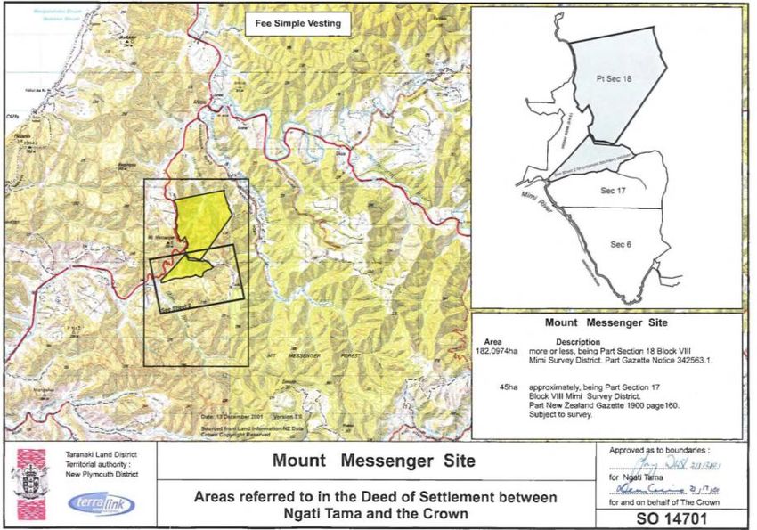
2

       values of the area. Naturally, there is some difficulty for Ngati Tama with the
       proposed option, and we are yet to formalise our position on this. The purpose
       of this report is to record that we have been involved in the process and
       provide some insight into the cultural importance of this area.

8.     We have now held four hui-a-iwi in the process of considering this project to
       date. At these hui-a-iwi, members of Ngati Tama conveyed many of the
       concerns, stating that there is no good option, as all options impact the mauri
       of the area and Ngati Tama. They conveyed the position of ‘not one more
       acre’ in response to NZTA’s desire to put the road over Ngati Tama land. All of
       the options were described as a breach of the Treaty, and conflict with the
       Ngati Tama Treaty settlement. Beyond the Treaty land aspect, the project
       affects ancestral lands and areas of importance to Ngati Tama and is
       considered to compromise our mana and kaitiaki responsibilities and is a
       transgression against these important values and responsibilities.

II.    PROJECT

9.     The Runanga is aware that the Project seeks to deliver much needed
       improvements to the Parininihi section of SH3, which is an important transport
       link between the Taranaki and Waikato regions. The Runanga and wider
       members of Ngati Tama have heard the views of members of the public and
       experts for the Agency on the benefits of the project. However, this does not
       justify the impacts of the project on Ngati Tama. These are matters we need
       to address.

III.   NGATI TAMA ROHE

10.    In Ngati Tama tradition, Ngati Tama descend from Tamaariki, Rakeiora, and
       Whata.

11.    For many generations Ngati Tama have occupied, defended, and exercised
       mana over the land between the Mokau river on the west coast of the North
       Island, southward to the Titoki stream that flows into the sea at Waiiti Beach.

12.    Extracts from the book “History and Traditions of the Taranaki Coast” provide:

             “South of the Mokau to Puke-aruhe pa, just south of the White Cliffs, a distance of about
             twelve miles, was the home of Ngati-Tama tribe-generally known as Pou-tama. This
             country has played a most important part in the history of the coast, and, therefore, is
             worthy of a little more detailed description, which Mr. W. H. Skinner supplies, as follows: -
             “From Puke-aruhe northward, the forest clad ranges and steep ravines effectually
             barred all passage, other than that by the narrow strip of beach at the base of Pari-
             ninihi, or White Cliffs. The old Maori track wound down the slopes of the Puke-aruhe
             plateau, and came on to the beach at the Waikaramarama Gorge. From here
             northward to Te Horo, at the north end of the White Cliffs, a distance of three miles, the
             route lay along a fine stretch of sandy beach, but quite impassable at high-water, for
             the waves washed the foot of the high cliffs that rose for 900 feet from sea level the
             whole way. About mid-way, the Wai-pingao stream flows out of a gorge in the cliffs,
             and offers a coige of safety to those caught by the tide. It was here a tragedy occurred
             to be related later on… At Te Horo, the old Maori track turned abruptly up the cliff, the
             ascent being made by stakes driven into the each to which ropes were attached. This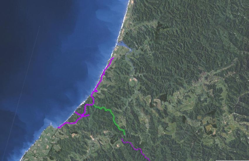
3

            ascent is necessary owning to a point of land jutting out into the sea called Te Rua-
            taniwha (the Taniwha’s lair), and which presented an impassable barrier to those
            desirous of proceeding along the beach. Here it was that Te Whiti was killed… Strange
            to say, the small plateau at the summit of Te Horo, over which the old track passed was
            not fortified, the reason possibly being, that, although practically impregnable from an
            attack on the south, where no danger to Ngati-Tama was to be apprehended, the
            place lay open to the north... From here the track descended into the Wai-kororo
            (probably Wai-karoro, the latter word be meaning a sea-gull) valley at its junction with
            the sea. From here, at low water, the track led along the beach all the way to Mokau
            river; but at high water, Wai-kororo and Tamure-nui (great schnapper) streams were
            crossed; whence the track ascended to the plateau which here lies along the top of
            the cliffs at an elevation of some two hundred feet above the sea. Here was situated
            Katikati-aka pa, at three and a half miles from Puke-aruhe, and which was an important
            fortress in former days…

            Ngati Tama, in fact, held the keys of Taranaki, and they proved themselves very capable
            of doing so.

            Their territory has very many fine pas in it, the most celebrated of which have been
            mentioned…”

13.   The map of Ngati Tama rohe is set out in the Taranaki Report: Kaupapa Tuatahi
      as follows:

14.   This map also shows the confiscation line and the lands that were confiscated
      from Ngati Tama.

15.   The rohe of Ngati Tama is recorded through the following account:

            Mai Te Titoki ki Pukehinau
            No Pukehinau ki Puau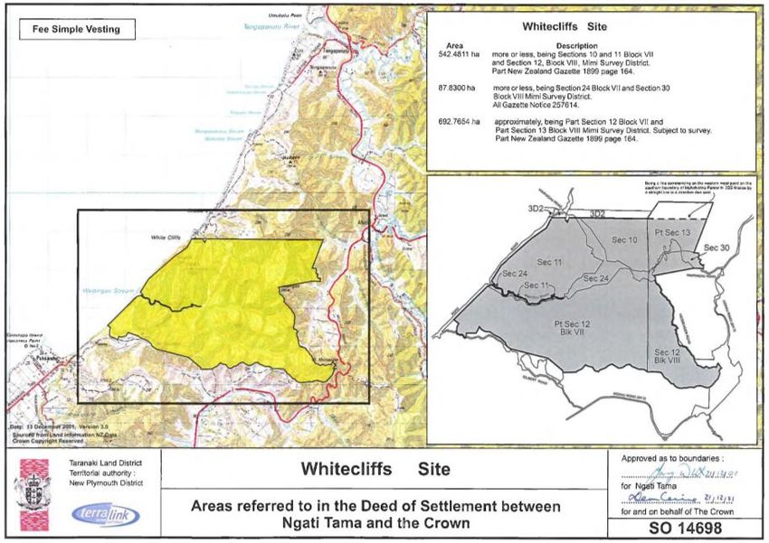
4

             No Paua ki Wairarawa
             No Wairarawa ki Pukekuri
             No Pukekuri ki Mokino
             No Mokino ki Tapuitautu
             No Tapuitautu ki Mangatitoko
             No Mangatitoki ki Waitara
             No Waitara ki Makarakia
             No Makarakia ki Te Ahu
             No Te Ahu ki Rereua
             No Rereua ki Potaka
             No Potaka ki Kahikatoa a Tute
             No Kahikatoa a Tute ki Tieketangiroa
             No Tieketangiroa ki Te Pou Atakirau
             No Te Pou Atakirau ki Haumapu Kahu ki te Whakarua
             No Haumapu ki Takoraparoa
             No Takaraparoa ki Pou Arohutu
             No Pou Arohutu ki Nehunui
             No Nehunui ki Tepora
             No Te pora ki Te Pou Whakairo
             No Te Pou Wakairoa ki Tiritirimatangi
             No Tiritirimatangi ki Kaihapuku
             No Kaihapuku ki Matukumaitua
             No Matukumaitai ki Panirau a Kahu Whaka te Ngutu o Mokau
             No Panirau ki Pukeruru a Tawariki
             No Tawariki ki Te Totara
             No Totara ki Tauwhare
             No Tauwhare ki Haumapu
             No Haumapu ki Te Ranginga
             No Te Ranginga ki Oturi
             Konei te rohe o Ngati Tama

16.   There were many concentrations of Ngati Tama activity along the coastal and
      fresh water converges of Mohakatino, Tongaporutu, Parininihi, Pukearuhe and
      Titoki. Among the pa sites and waterways include Katikatiaka Pa, which lies
      adjacent to the Waikorora Stream, and pa associated with the mouth of the
      Waipingao Stream, which has its head waters at the maunga, and the mouth
      of the Mangapukatea and Waikiekie streams.

17.   The Tongaporutu and Pukearuhe areas receive particular mention in the
      Taranaki Report as areas that Ngati Tama held strong kainga and pa within
      their ancestral rohe. The bush area is also important. The inland bush area
      played an important role in the customary practices of Ngati Tama and were
      important resources and icons, along with the many streams, ridgelines and
      peaks of this area, and continue to do so today. The importance of the bush
      area is also reflected in extracts from the “History and Traditions of the Taranaki
      Coast”:

             “… The object sought in placing a settlement so far inland was so as to be near the pua-
             tahere, or bird preserves, where Kakas, pigeons, Wekas, Kiwis, Tuis, and other birds were
             plentiful; and also in order to obtain the kokowai or oxide of iron…”

             …

             “About one hundred yards beyond Katikatiaka, the track turned down again to the
             beach-along a fault in the cliff-and then passed, at a half mile further on, the Wai-kiekie
             stream, inland of which, on a slope, stood the Tihi-manuka pa… From this pa a track led
             through the forest country, directly inland to the Whanganui, striking the river at Marae-
             kowai. This and the Taumata-mahoe track, starting from the Ure-nui river, were the only
             two in this part of the country affording means of communication between the sea
             coast and the upper Whanganui and the interior.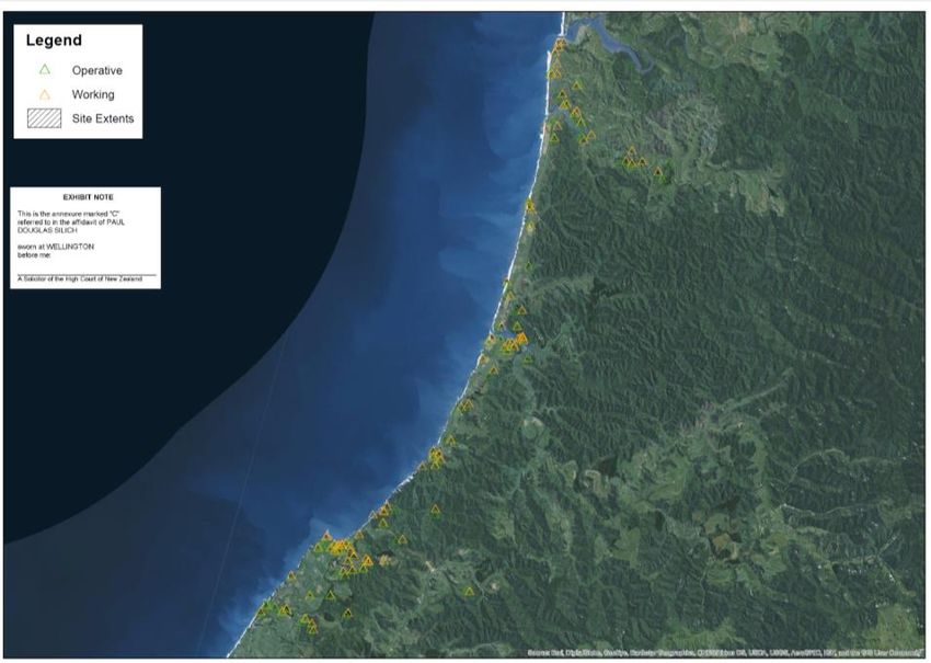
5

             …

             To the ancient Maori this country of the Ngati-Tama was an ideal one-a land to be
             desired and fought for. It offered numerous sites to the old warriors, perfect in their way,
             for their pas or fortified villages; positions of such great natural strength and the
             advantages surrounding them that it was scarce conceivable to improve upon them.
             The narrow strip of level or undulating land-about half a mile wide-between the sea and
             the foot of the wooded ranges, was rich and easily worked, and more than ample for
             all their wants in the growth of kumara, taro, and other vegetables. Two fine streams,
             the Tongaporutu and Mohakatino, besides numerous smaller ones, abounded with eels,
             whilst the forest ranges offered good returns to the bird-snarer. At their feet the ocean
             literally teemed with life…”

18.   Within this rohe, the waterways and mountain peaks from which the waters are
      sourced have cultural and spiritual importance to Ngati Tama. The waterways
      of this area are significant resources to Ngati Tama and have sustained Ngati
      Tama identity, customs and livelihoods for generations. The bush and
      waterways are interconnected through the korero or ‘Tanetewaiora’ (Tane,
      the deity of the forest and bush, is the source of fresh water). The area affected
      by the project has been and remains an area of major importance to Ngati
      Tama as an important part of our rohe, traditions, customs and identity.

      Ngati Tama land loss

19.   The effects of the land confiscation and Native Land Court decisions on Ngati
      Tama are recorded in detail in the Taranaki Report: Kaupapa Tuatahi which
      states:

             “The result for Ngati Tama was disastrous. We are not aware that other hapu were
             affected as seriously. Without any evidence that they had participated in the war,
             74,000 acres of their land were confiscated, of which a mere 3458 acres were returned,
             and then to only 12 persons. The remainder of their lands, probably some 66,000 acres,
             was transferred to others, leaving the rest of Ngati Tama landless. The West Coast
             Commission noted their plight, however, and recovered a further 576 acres for them.
             The commission was critical of the Native Land Court, reporting on 26 April 1884:

                     The ancestral northern boundary of the Ngatitama tribe was the Mokau River,
                     which was many years ago shifted to Mohakatino by the peace arrangements,
                     after long hostilities. Subsequently the Northern tribes drove the Ngatitamas from
                     the district, and they migrated to the South, where they remained until the
                     arrival of European settlers, when they began to return, and settled in many
                     places so far as Tongaporutu. During some of the meetings held in Waikato
                     under the auspices of the Maori King movement the Ngatitamas were invited
                     to attend, which they did, and were formally promised the restoration of their
                     ancient rights to the land, and recommended to live on it, which they were
                     doing (so far as Tongaporutu), when the Native Land Court sat and by its
                     decision completely upset the understanding which had been arrived at. So far
                     as I have been able to ascertain the facts, the Ngatitama failed to establish
                     their case in consequence of a mistake in the manner in which it was brought
                     before the Court, and if they had been allowed a rehearing, for which they
                     applied, they would most probably have succeeded in establishing their right
                     to the land between Tongaporutu and the Confiscated Block; but the Chief
                     Judge of the Land Court positively refused a rehearing. The Ngatitama, being
                     thus stripped of all the land they had, were thrown on the world, and appealed
                     to the Government. The Hon the Native Minister, Mr Bryce, suggested to the
                     Commissioner to locate them inside the confiscated boundary; and, there
                     being a small block of about 576 acres near Pukearuhe available for this
                     purpose, which they were willing to accept, it was surveyed for them, and they
                     have been put in possession of it.
6
Some of them had previously been occupying a portion of town-belt on the
south side of the Town of Pukearuhe, which is never likely to be more than a
town on paper, and which had, by a former arrangement with the Crown
Agent, been made available for settling Native claims. It has been thought
desirable to add 71 acres of this belt to their award.
The reserve of 576 acres, which was all in bush, was individualised and apportioned
between 50 persons, giving some 12 acres each. For having lost some 134,000 acres,
Ngati Tama received in all 4056 acres, even though they were not involved in the war.
It is hardly surprising Ngati Tama are not a numerous tribe today, for there was no land
to sustain them.”
20. These references highlight the importance of the Pukearuhe and confiscated
land area to Ngati Tama which is where the project occurs.
21. It is also noted as a side issue that the interference of the Crown and Native
Land Court in Ngati Tama rohe remains an issue to this day and Ngati Tama
maintains its tribal boundaries up to Mokau. The Taranaki Report: Kaupapa
Tuatahi discusses the ancestral lands of Ngati Tama as follows:
“By descent from the original peoples and subsequent migrants of the Tokomaru waka,
Ngati Tama were the ancient holders of a large territory from the far side of the Mokau
River in the north to Titoki in the south. Subsequently, by war and marriage, Ngati Tama
and Ngati Maniapoto had fused at Mokau. Ngati Rakei and other hapu emerged there
with connections to both groups in the usual Maori way. Of course, while being
connected with both Ngati Tama and Ngati Maniapoto, Ngati Rakei and the associated
hapu also had an autonomy of their own.
…
… The Native Land Court was also very political at this time and sensitive to which groups
were in the Government’s favour. In addition, there is evidence that at that time the
court was seeking to ingratiate itself with the Ngati Maniapoto side of Ngati Rakei in
order to be accepted into the King Country.
In any event, in a brief judgment the Native Land Court determined that Ngati Tama
had been expelled from their lands by Waikato-Maniapoto conquerors and that the
conquerors had taken possession of the vacant land, which possession, though ‘sparse’,
was none the less sufficient to show ‘a domiciliary intention’. On the other hand, the
Ngati Tama reoccupation was ‘desultory’ and ‘trivial’ in the court’s view and it was
insufficient to displace the conqueror’s possessory title, obtained by Maori custom.
… Like the Compensation Court, the Native Land Court elevated conquest according
to European tradition, while Maori placed more weight on whakapapa (genealogy)
and ancestral associations. These were Ngati Tama lands. They had been their lands for
centuries, and by Maori custom, the Ngati Tama ancestral interests were not so readily
extinguishable. An ancestral history is a fact that cannot be written out of existence. The
only question was whether some adverse possession had intervened to prevent Ngati
Tama reoccupying their ancestral lands. Clearly, none had, or at least not for the whole
of the land. Any adverse possession was confined to a few pockets and did not affect
the greater part. Ngati Tama could not have been stopped from returning to their land,
and they in fact did return. In any event, the possessors of those pockets were not in fact
the so-called conquerors. The Waikato-Maniapoto invaders came and went. They did
not perfect by occupation such rights of conquest as they may have claimed. Those
who occupied the lands, in the absence of Ngati Tama, were Ngati Rakei, who were as
much related to Ngati Tama as they were to Maniapoto. Their entry upon the land was
limited in scope and concept. They settled in the absence of Ngati Tama, and their right
to settle in their absence was not by conquest but by whakapapa.
In Treaty terms, however, the main concern is that the Native Land Court was authorised
to determine such a question. It had no business to do so in this instance. The Treaty
vested the authority of Maori lands in Maori, not in the Native Land Court, and that must
have included the right of Maori to maintain their own way of reaching agreements. To7
the extent that it presumed to decide for Maori that which Maori should and could have
decided for themselves, the Native Land Court encroached on Maori autonomy and
was acting contrary to the Treaty of Waitangi. It follows that the legislation that permitted
of that course was also inconsistent with Treaty principles.
It needs to be appreciated, then, that Maori dispute resolution was founded not upon
finite rules, like those the Native Land Court imposed, where some won and others
missed out, but upon the reaching of pragmatic solutions. Had the court permitted of a
Maori process, a just and pragmatic solution was likely. The elements were there.
Waikato made it clear that they supported the return of Ngati Tama. If, in the court’s
reckoning, these were the people who were supposed to have taken the land by
conquest, then that fact, known to the court, deserved weight. In any event, a
pragmatic solution was at all times feasible and the court need not have done more
than record it. Ngati Rakei occupied only pockets of land. Nothing could prevent the
hapu from fusing in the usual Maori way or keep Ngati Tama from the balance —
nothing, that is, but the Native Land Court.
The real problem appears to have been that the Native Land Court was mainly
concerned with promoting itself…”
IV. CULTURAL SITES AND PLACES
Treaty settlement
22. As part of our historical settlement with the Crown to redress the past breaches
of the Treaty of Waitangi, the Ngati Tama settlement included commercial and
cultural redress items.
23. The Ngati Tama Deed of Settlement cultural redress included the transfer of
parcels of Conservation land areas, including areas (relevant to the Project)
referred to as:
a. The Whitecliffs Site;
b. The Mount Messenger Sites.
24. We have decided to refer to these areas as ‘Parininihi’.
25. These land parcels are of great significance to Ngati Tama, and are regarded
as the ‘jewel in the crown’ of the Ngati Tama historical settlement. The Parininihi
Protection Project Strategic Plan records this point, noting:
“Parininihi was returned to Ngāti Tama by the Crown in 2003, and has a rich history of
preEuropean occupation, shown by the numerous kainga and pa sites. Ngāti Tama
wish to protect this land and ensure that it remains a jewel in the crown of Taranaki for
all to enjoy.”
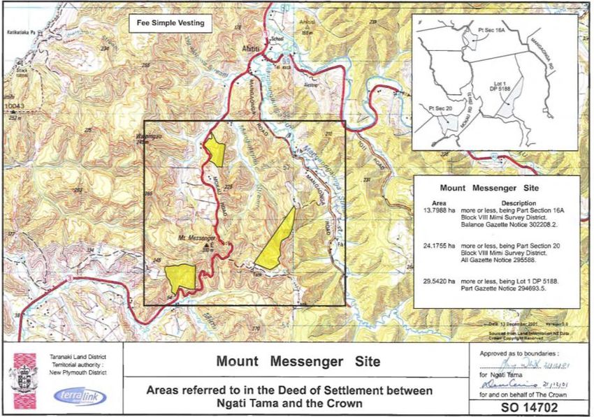
26. The Whitecliffs site is shown as follows:8 27. The Mt Messenger sites are shown as follows:
9

28.   Further, when the settlement was negotiated, the transfer of these lands was
      effectively the key to the settlement going through.

29.   Following some 18 months of intense negotiations, Ngati Tama was offered less
      than 5 hectares of Department of Conservation land in its Settlement package.
      The offer was rejected and negotiations had come to an impasse.

30.   During this time, Ministers were also seeking to establish a marine reserve which
      Ngati Tama opposed. In a final attempt to reach a settlement, an offer was
      made to Ngati Tama which involved the transfer of the DOC land (and the
      Tongaporutu Recreation Reserve). The Ministers sought that in exchange for
      this, Ngati Tama would withdraw its opposition to the Marine Reserve. This was
      ultimately agreed.

31.   The features of the offer were:

         a. the DOC land was to be granted in fee simple title;
10
b. the Tongaporutu Recreation Reserve was to be granted in fee simple,
subject to the approval of the New Plymouth District Council, (NPDC)
the then administrating entity. (a mere formality according to the
Crown). This was the only site that generated any economic return
(however meagre) and was considered by the Crown and Ngati Tama
to be a critical element of the offer;
c. and, Ngati Tama would withdraw its opposition to the Ministers Marine
Reserve Application.
32. Ngati Tama thus withdrew its opposition to the Marine Reserve, which was then
established. After reaching agreement on the above points, there was further
negotiation on other details. It was during this later discussion that the Joint
Advisory Committee and covenant emerged as mechanisms to enable Ngati
Tama access to the DOC fund in order to maintain the land and implement
the management plan.
33. The transfer of the Tongaporutu Recreation Reserve never eventuated due to
opposition by the Council and other interests, which remains a source of
discontent to this day. This was notwithstanding that we held up our side of the
deal to remove opposition to the marine reserve which was subsequently
confirmed.
34. Also, since settlement, we have struggled away with the maintenance of the
land and pest control. Notwithstanding the fact that we agreed to the
covenant over the land in exchange for the Crown covering the costs of
maintenance and pest control, this has proven a constant battle.
35. In addition to the transfer lands, the Treaty settlement includes statutory
acknowledgements and deed of recognition for Mount Messenger
Conservation Area, shown as follows:
36. The deed of recognition for the Mount Messenger Conservation Area is
recorded in the Deed of Settlement (Schedule 2 – Cultural Redress Schedule)
as follows:11
1. AREA
The area to which this Deed of Recognition applies is the area referred to in the Deed
of Settlement as Part of the Mount Messenger Conservation Area in the Area of Interest
(the, “Area”), the general location of which is indicated on SO 14706.I
2. CULTURAL, SPIRITUAL, HISTORIC AND TRADITIONAL ASSOCIATION WITH THE AREA
2.1 This is an important area containing Ngati Tama pa sites and mahinga kai sources of
birds and fish.
2.2 The once great Katikatiaka Pa was located here, inhabited by the descendants of
Uerata who were among the fighting elite of Ngati Tama. It was an important vantage
point, built in two divisions, and extending to the seaward clifftops. Tihi Manuka, a refuge
pa, also situated in the area, was directly connected to an important inland track.
2.3 Kiwi, kahurangi, kereru, eels, inanga and the paua slug were traditional resources
found here. Papa clay types found here were used for dyeing muka. A range of
temperate zone flora was also available to Ngati Tama from this area including beech,
rata, rimu, and a variety of ferns. Important mahinga kai streams include Te Horo,
Ruataniwha, Waipingao and Waikaramarama.
37. The commercial redress component of the Treaty settlement included a
financial redress sum of $14.5 million. Unfortunately, the cash redress to Ngati
Tama has been dissipated due to unsuccessful investments.
38. Putting aside this loss, there is other context to the commercial redress to note.
Ngati Tama agreed its Treaty settlement relatively early. At the time of the
negotiations, we were part of a group of iwi that were negotiating together,
and were offered similar commercial redress amounts. However, due to other
reasons, the other iwi were unable to enter into a settlement at the time,
whereas we were able to proceed. We therefore entered into the settlement
as outlined above. Since we settled, we have observed the settlements of
other iwi surrounding us, including those who were in the same negotiation
group as us. We have seen those iwi achieve commercial redress outcomes
which are over three times what we settled for. We have seen other iwi, who
may not have suffered the same extent of confiscation as we did achieve
commercial redress in order of magnitudes greater than what we did. In our
view, there is little method to Treaty settlements. It depends on negotiation,
chance and political will and we have seen how this can change over time,
and in our case to our disadvantage. Being a political outcome, it has little
relationship to the rights and interests and tino rangatiratanga enshrined in the
Treaty relationship and we are very aware that the settlement compensated a
minute fraction of what was lost. In our view, it is important that a methodology
that properly recognises the pre-existing rights of Ngati Tama is recognised.
39. Another feature of the Treaty settlement that we are very aware of is that it is
a full and final settlement. While we continue to have our reservations about
the durability of the settlement, we equally have to turn our minds to what the
Treaty relationship means going forward. In our view, the Treaty settlement
sought to restore the mana and rangatiratanga of Ngati Tama in our rohe and
put the Treaty relationship on its proper footing. What this means in practice is
something we are still exploring. In our view, the bypass project would infringe
the full and final nature of the Treaty settlement which is an important factor to
be considered.
Cultural landscape
40. Ngati Tama occupied a number of pa sites along the coastal area as well as
pa sites inland.12
41. There were and remain important tracks which provide the connection
between the coastal area and the important mahinga kai and other inland
resources of Ngati Tama.
42. The Mount Messenger connection to the coastal pa is reflected in walking
tracks through this area which continue to this day. A map illustrating walking
tracks of the area is provided below, which show the walking track along the
ridge from the Mount Messenger peak.
43. The following plan shows many of the coastal pa sites:
Parininihi kaitiakitanga
44. As noted, the Whitecliffs and Mount Messenger area is known to Ngati Tama
as Parininihi. Parininihi has been referred to as ‘Te Matua Kanohi o Ngati Tama13
Whanui’, ‘The parent (principle) face of Ngati Tama’. It is an area of major
cultural significance to Ngati Tama.
45. From a practical perspective, the Parininihi land includes a ~2000ha biodiversity
rich coastal forest which Ngati Tama were repatriated with as part of our Treaty
settlement. The forest runs from the iconic coastal Whitecliffs inland to the
maunga and awa.
46. As touched on above, Ngati Tama, through the JAC, have the function of
putting in place a management plan for the Parininihi land.
47. The Tiaki Te Mauri o Parininihi Trust (“Trust”) implements the management plan.
The name ‘Tiaki Te Mauri o Parininihi’ itself is poignant, meaning ‘to care for the
mauri of Parininihi’.
48. An important part of the Parininihi land is its role in the re-introduction of kokako
into Taranaki.
49. The Trust website outlines the background and significance of the Kokako
project as follows:
The return of kokako to Taranaki is a central aim of the trust. In 1999 the last Taranaki
kokako, ‘Tamanui’ was removed from the Moki Forest (North Taranaki), on the
understanding that his progeny would be returned once the damaged eco-system was
restored and a safe breeding site established. Tiritiri Matangi has provided a safe haven
for breeding and Tamanui’s descendants have multiplied. It is now time to bring them
back to Taranaki.
Kokako are part of the ancient wattlebird family and are cousins of the extinct huia and
the endangered tieke (saddleback). Kokako were once widespread throughout the
lowland forests of Aotearoa, but predation and loss of habitat has taken a heavy toll.
Kokako are famous for their haunting call, like deep ringing bells. Their song carries for a
great distance and is heard mostly at dawn, when birds call to maintain their
territories. Pairs may duet for up to half an hour, with other kokako joining in to form a
“bush choir”. Calling is so important that recorded calls are played when kokako are
released to help “anchor” the birds in new areas.
Mature podocarp-hardwood forest provides the diverse food supply that Kokako
need. The rich forests at Parininihi provides the food and shelter required for kokako to
bread successfully. The abundant food supply, however also benefits rats, stoats and
possums. Kokako are especially vulnerable to predation therefore these invaders must
be controlled if kokako and other taonga (treasures) are to survive. In order to ensure
the safety of the returning kokako, intensive animal pest control needs to be maintained
to keep rats, stoats, possums and goats to very low numbers.
With dedicated effort the call of the kokako will be heard again.”
50. The Parininihi Protection Project Strategic Plan records some of the kaitiaki
values associated with Parininihi as follows:
“The Tiaki Te Mauri O Parininihi Trust has been established to manage the protection of
Parininihi. …
Parininihi extends over three bioclimatic zones from the coast to semi-coastal and
lowland forest. This encompasses a wide range of habitat types, from dunes and coastal
cliffs to wet valley floors and dry forest ridgelines. Inland Parininihi is contiguous with
protected forests on the Conservation Estate and Ngāti Tama lands.14
The TRC recognises Parininihi as a Key Native Ecosystem, and DOC rank Parininihi as a
priority site in Taranaki.
The Waipingao Stream forms the central water catchment, and is surrounded by steep
ridges. Biodiversity values are high, with at least 40 species either being rare or absent
elsewhere in the ecological district.
Kiwi, karearea (falcon), kereru, mātātā (fern bird), titipounamu (robin) and pekapeka
(bat) are among notable species found at Parininihi. Kaka, titi, spotless crake and
kōkako were present in the past. Parininihi is also at the ‘meeting zone’ for insects with
largely southern or northern distributions, and has a very diverse insect fauna.
The forest canopy is dominated by abundant tawa, kohekohe, hinau, rewarewa and
pukatea; with emergent rimu, miro, northern rata and kahikatea. Tawari, kamahi, towai,
puriri and mangeao are also present. Nikau and kiekie are common where the canopy
has been disturbed in the past by slips of fires.
The forest understorey is dense and diverse, and has a large population of the now rare
king fern Marattia salicina. King fern have disappeared from many areas due to
browsing by goats, and it’s presence at Parininihi is a sign of a healthy forest. The healthy
forest understorey and sub canopy provides a significant amount of food for native
birds, and helps protect the forest canopy from storm damage and drought.
Towards the coast are ngaio-taupata treelands, with scattered patches of titoki,
wharangi, ngaio, puka and akeake. Harakeke/wharariki flax are found as well as
halophytic herbs, including the nationally endangered Matangaoa NZ cress Rorippa
divaricate and coastal forget-me-knot Myosotis petiolata var pansa. Pingao, a
significant weaving plant, is found on the dunes.
Off the Parininihi coastline is the 1800 ha Parininihi Marine Reserve, which encloses a
typical slice of the North Taranaki coastline, as well as the possibly unique sponge
gardens of Pariokariwa reef. The diversity of species encrusting the reef is amongst the
highest recorded anywhere in New Zealand and ranks highly internationally.
…
Reintroduction of Kōkako: returning the progeny of Tamanui
Kōkako were once common in Taranaki, but have become extinct in the region. The line
of Taranaki kōkako has survived through a single male bird, Tamanui, who was removed
from Moki Forest in North Taranaki in 1999. Tamanui was taken to the safety of
Tiritirimatangi Island, and today his progeny are ready to return to Taranaki.
Kōkako are very vulnerable to predation and habitat decline, and require intensive
animal pest control and healthy forest to survive. The diverse forest at Parininihi provides
the food supply and shelter that kōkako need to breed successfully. Provided that
animal pest control targets are met, the Kōkako Recovery Group has selected Parininihi
to be the first site in Taranaki for kōkako to be reintroduced. …
…
The predator control network at Parininihi must be sufficient to provide kōkako the
protection they need to re-establish. Rat and possum monitoring will keep a close eye
on predator numbers and ensure that safe levels are maintained. …
The vulnerability of kōkako to predation, and their need for healthy forest, means that
the protection of kōkako will ensure the protection of all biodiversity at Parininihi. The
reintroduction of kōkako will also herald the return of a vibrant dawn chorus…”
51. The Parininihi project is recognized as a significant conservation project
regionally and nationally. After many years of preparation and work, the
descendants of the Taranaki Kokako were recently returned to Parininihi. This15
is something that Ngati Tama are very proud of and is a source of mana for our
tribe.
Awa and ngahere
52. The project will also impact on important awa and ngahere attributes that are
important to Ngati Tama. At the time of wrting this paper, we are still working
through the reports and discussions with experts to fully understand the details
of these impacts. We are aware that a number of very old and significant
rakau (trees) are sought to be felled to make way for the road. There will be a
number of streams as well as the awa of this area affected by the project.
These are matters we are still considering and undertaking assessments of so
that we can fully report these matters to our whanau.
V. CULTURAL IMPACTS
53. There are significant cultural values associated with Parininihi. These include
the following:
a. Firstly, the value of Parininihi as the jewel in the crown of the Ngati Tama
settlement, representing return of Ngati Tama collectively held lands
within our ancestral rohe;
b. Strong kaitiakitanga associations;
c. Parininihi is referred to and considered a taonga;
d. The important flora and fauna of Parininihi is a taonga;
e. The importance of Parininihi to a cultural, spiritual and resourceful
sustenance of our iwi.
54. In the context of this Project, we note the following points:
a. The principles of the Treaty of Waitangi are relevant. The impacts on our
ancestral whenua, waterways and ngahere, including the Treaty
settlement land, causes offence and in our view represents a breach of
Treaty principles to protect us in the use and possession of our taonga;
b. The impacts on the mauri of the whenua and Ngati Tama contravene
our mana and kaitiaki rights and responsibilities and are difficult for many
of our people to accept and reconcile;
c. Without properly addressing the impacts, this would leave an ongoing
sense of failure to uphold our mana and kaitiaki responsibilities, and can
have ongoing impacts, and could act as a constant source of
‘whakama’ and ‘riri’ for our people.
VI. PROCESS AND POSSIBLE MEASURES TO ADDRESS IMPACTS
55. Te Runanga o Ngati Tama has agreed to continue dialogue with NZTA to see
whether the impacts on Ngati Tama can be addressed and if so how. This has
been an exploratory exercise to consider how such matters may be addressed16
56. The process adopted by the Runanga has been that we would enter into
discussions with the Transport Agency and hear and explore measures, but that
these would be matters to be taken back to Ngati Tama hui-a-iwi. This is still an
ongoing process. At this stage, there are no final agreements and we therefore
cannot provide any insight on this.
57. The Parininihi lands and waters (along with all resources of our rohe) provide for
the cultural, spiritual and resourceful sustenance of our iwi.
58. We are aware that the Project seeks to provide for the safety, efficiency and
economic benefit of the region. The ongoing sustenance of Ngati Tama from
our rohe and taonga is an important factor which is integral to our relationship
with our rohe and taonga. This is the rohe and taonga we are bound to, and
which sustains us culturally, spiritually and physically and which in turn we have
responsibilities to. These ancestral rights are affirmed in the Treaty relationship.
In our view, it is necessary to consider the long term sustenance of Ngati Tama.
Our experience is that the long term sustenance of Ngati Tama is not borne out
by activities of public benefit, and our ancestral rights and taonga are
relegated and depleted for the wider public benefit. These are matters that
we are continuing to explore with NZTA.You can also read