A WORLDWIDE 3D GCP DATABASE INHERITED FROM 20 YEARS OF MASSIVE MULTI-SATELLITE OBSERVATIONS
←
→
Page content transcription
If your browser does not render page correctly, please read the page content below
ISPRS Annals of the Photogrammetry, Remote Sensing and Spatial Information Sciences, Volume V-2-2020, 2020
 XXIV ISPRS Congress (2020 edition)

 A WORLDWIDE 3D GCP DATABASE INHERITED FROM 20 YEARS OF MASSIVE
 MULTI-SATELLITE OBSERVATIONS

 L. Chandelier 1*, L. Coeurdevey 2, S. Bosch 2, P. Favé 1, R. Gachet 1, A. Orsoni 1,, T. Tilak 1, A. Barot 2,
 1
 IGN, 6 avenue de l’Europe, 31520 Ramonville, France -
 (laure.chandelier, pascal.fave, roland.gachet, alain.orsoni, thomas.tilak)@ign.fr
 2
 Airbus Defence and Space, 5 rue des Satellites, BP 14359, 31030 Toulouse Cedex 4, France -
 (laurent.coeurdevey, sebastien.bosch, alexis.barot)@airbus.com

 Commission TCII/1

KEY WORDS: Ground control point, Space reference point, SPOT 6/7, SPOT 5 HRS, registration, massive image processing,
 cloud computing

ABSTRACT:

High location accuracy is a major requirement for satellite image users. Target performance is usually achieved thanks to either
specific on-board satellite equipment or an auxiliary registration reference dataset. Both methods may be expensive and with certain
limitations in terms of performance. The Institut national de l’information géographique et forestière (IGN) and Airbus Defence and
Space (ADS) have worked together for almost 20 years, to build reference data for improving image location using multi-satellite
observations. The first geometric foundation created has mainly used SPOT 5 High Resolution Stereoscopic (HRS) imagery,
ancillary Ground Control Points (GCP) and Very High Resolution (VHR) imagery, providing a homogenous location accuracy of
10m CE90 almost all over the world in 2010.
Space Reference Points (SRP) is a new worldwide 3D GCP database, built from a plethoric SPOT 6/7 multi-view archive, largely
automatically processed, with cloud-based technologies. SRP aims at providing a systematic and reliable solution for image location
(Unmanned Aerial Vehicle, VHR satellite imagery, High Altitudes Pseudo-Satellite…) and similar topics thanks to a high-density
point distribution with a 3m CE90 accuracy.
This paper describes the principle of SRP generation and presents the first validation results. A SPOT 6/7 smart image selection is
performed to keep only relevant images for SRP purpose. The location of these SPOT 6/7 images is refined thanks to a
spatiotriangulation on the worldwide geometric foundation, itself improved where needed. Points making up the future SRP database
are afterward extracted thanks to classical feature detection algorithms and with respect to the expected density. Different filtering
methods are applied to keep the best candidates. The last step of the processing chain is the formatting of the data to the delivery
format, including metadata. An example of validation of SRP concept and specification on two tests sites (Spain and China) is then
given. As a conclusion, the on-going production is shortly presented.

 1. INTRODUCTION model should target accuracy of around 3m, that is to say, up to
 2m better than the satellite native location requirement.
A large part of the Earth Observation market (EO) anticipates
better image resolution, better accuracy, cost saving platforms Ensuring native high location accuracy on satellite involves
and massive processing. Imagery location accuracy, and extremely expensive on-board equipment (gyrometer, star
subsequently horizontal performance for orthoimages, is a key tracker, etc.) as well as significant monitoring costs for
requirement for users. This request increases dramatically with calibration tasks. Despite their sophistication, a stable location
the data resolution, needs of geometrically consistent images for performance of around 4m (a few micro radians) is the current
time series analysis, addressing various scales, from local with limit nearly achieved with on-board equipment. Such a design
aerial data to global with satellite data. For very high resolution, also generates a risk since a failure of this equipment would
a location standard of 5m is emerging, potentially more have a critical impact on the mission. Exceeding this
demanding in the future. performance and/or costs means on-ground geometric model
 refining, possibly by image processing. Fully automatic refining
 2. NEED FOR NEW GENERATION OF processing is expected by image matching on large reference
 REGISTRATION DATABASE data of higher accuracy. Global registration databases are
 designed to fulfil this refining processing.
2.1 Context
 2.2 Example of existing global registration databases
The coming Pléiades Neo new constellation (Airbus, 2020) of
optical satellites with a 30cm resolution shall fulfil the location This section presents global approaches – worldwide coverage –
accuracy requirement better than 5m at sensor level. in the satellite imagery case.
Pléiades Neo also intends to achieve a planimetric accuracy on
moderate slopes (
ISPRS Annals of the Photogrammetry, Remote Sensing and Spatial Information Sciences, Volume V-2-2020, 2020
 XXIV ISPRS Congress (2020 edition)

As from 2002, SPOT Image S.A. Company Toulouse, France, 2.3 The SRP initiative
now part of Airbus Group, and IGN (Institut national de
l’information géographique et forestière), co-developed the The Space Reference Point (SRP) initiative was first introduced
concept of reference layers to produce the 3D worldwide in 2017 to challenge a 3m location performance worldwide for
database called Reference3D© (SPOT Image, 2011). the new Airbus’ Pléiades Neo constellation, through fully
Reference3D© contains a dual endogenous layer: a horizontal massive on-ground registration processing with no human
layer of continuous 5m optical orthoimages and a vertical layer interactions. As explained previously, achieving such an
with a 30m DSM (DTED2), both delivered with associated accuracy level will not be possible with a continuous
quality data. Source data are composed of SPOT 5 High orthoimage layer associated with a DSM. SRP is based on the
Resolution Stereoscopic (HRS) instrument with an extreme more promising 3D feature points approach, as a successor of
geometric rigidity, processed through continental block BDAmer.
triangulation over 80Mkm². The database was upgraded several
times with SPOT 5 High Resolution Geometric (HRG) then SRP is a global 3D GCP database built from SPOT 6/7 images
SPOT 6/7 orthoimages, and enlarged to continuously cover whose registration is mainly refined on a worldwide
more than 110Mkm². Today designated as Premium Accuracy stereoscopic HRS geometric foundation. With respect to the
Services (PAS), it provides a global accuracy for orthoimages of successive improvements made during twenty years by Airbus
6-8m CE90 horizontally and 5-10m LE90 vertically on and IGN in theirs co-works, the geometric foundation has
moderate slopes (
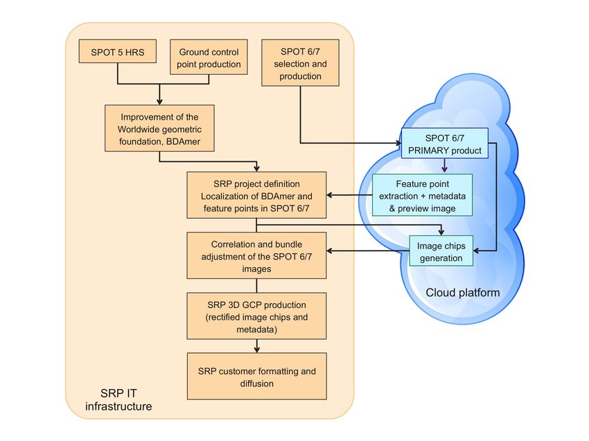
ISPRS Annals of the Photogrammetry, Remote Sensing and Spatial Information Sciences, Volume V-2-2020, 2020
 XXIV ISPRS Congress (2020 edition)

The SRP production began in March 2018, with a capacity of The geometric foundation is mostly composed of SPOT 5 HRS
3Mkm² per month, set to be ready over the “useful” Earth land images acquired between July 2002 and August 2014. HRS
surface (around 109Mkm²) at the end of 2020. Siberia, Northern images are stereoscopic pairs with a base to height ratio of 0.8.
parts of North America and remote islands are anticipated for They have a swath of 120km and a length of up to 600km with
the end of 2021, at least a total of 135Mkm². a 5mx10m pixel. Location performance at the single pair level
 has been estimated at about 27m at 90% (Bouillon et al., 2006)
 3. SRP PROCESSING CHAIN with no ground control points.

3.1 Global workflow and architecture The benefit of building blocks with these wide and rigid
 stereoscopic strips was quickly demonstrated to improve
A specific workflow has been developed to produce the entire location accuracy as well as global consistency between images.
SRP database in three years. The different steps of the SRP (Bouillon et al., 2006) shows that a bundle block adjustment
processing chain are described in the next sections. The figure helps achieve a location of better than 15m at 90%, without
below shows the global workflow and the architecture involved. GCP. Blocks were expanded in order to improve location
The first step, described in section 3.2, is the improvement of quality, to reach a more homogeneous location and to minimize
the worldwide geometric foundation. Simultaneously (see geometrical deviations at block borders. In 2009, tie points were
section 3.3), a smart selection of SPOT 6/7 on the entire archive automatically measured through a feature detection algorithm to
is computed and then input to launch the image production provide a homogeneous and controlled density of reliable tie
itself. From these two input data, feature points are detected on points (a few hundred points per square degree). External Z
a cloud platform (section 3.4) and used in a classical reference (Shuttle Radar Topography Mission, SRTM and Ice,
spatiotriangulation to refine the SPOT 6/7 image location and to Cloud, and land Elevation Satellite, ICESat data) has also been
keep best SRP candidates (section 3.5). At the end (section 3.6), added to the block in order to improve altimetry reliability or
SRP product is built from the most reliable points. quality.

 At the end of the 2000s, fine georeferencing becomes a central
 challenge for users who expect a location compliant with
 terrestrial positioning systems such as GPS. Consequently,
 external GCP were added to enhance the absolute location
 quality. (Breton et al., 2009) shows that the addition of GCP
 (approximately every 3,000km) and the computation of blocks
 of 1,000 images make it possible to reach a location close to
 10m.

 In 2013, 20,000 SPOT 5 HRS images were finally refined in a
 single block to ensure a unique and consequently coherent
 location all around the world. Increasing the size of the bundle
 adjustment blocks was possible thanks to a decrease in
 computation time, tuning of the different bundle adjustment
 settings (parameters and weighting), false point filtering and
 improvement of the point equipment (Massera et al., 2012). In
 order to reach the 3m CE90 accuracy all over the world, ground
 control points are added locally to the worldwide geometric
 foundation.
 Figure 2. SRP workflow
 3.2.2 GCP equipment
Since the global amount of data to be processed in the
workflow is at the petabyte scale, many optimisations were Numerous external GCP are needed to achieve the targeted
carried out to reach a reasonable production time. Thus, some accuracy for the SRP database. Over the years and with the
operations are directly performed on a cloud infrastructure. technical system maturity level, the offer in terms of GCP
Moreover, the worldwide production is divided into continental diversifies and widens:
batches in order to deliver the product gradually. Each batch is − Download of free available data: mainly permanent
made up of tens of thousands of images. A batch is a geodesic station networks and national orthoimage
continuous block of SPOT 6/7 images designed to have borders programs (as BDOrtho® for France).
in accordance with the landscape (to avoid borders between − Purchase of GPS points provided by surveying
blocks in difficult areas such as mountains) and with an companies.
overlapping area between blocks. − Very High Resolution independent group of n image with
 native unbiased calibration around !"#$% = 5
3.2 Improvement of the worldwide geometric foundation
and its BDAmer (Geoeye, Pléiades, WorldView, possibly mixed) allow to
 build a “Ground control image” with an accuracy better
 !!"#$%
The location accuracy is mainly founded on a worldwide stereo than meters (Massera et al., 2012).
 !
image bundle block adjustment with external GCP, called − Airbus Albatros airport database: these are Pléiades
“geometric foundation” in the following sections. orthoimages adjusted in most cases on GPS GCP and
 rectified on a very fine endogenous DTM.
3.2.1 SPOT 5 HRS block
 Others sources could be used as radar imagery GCP (TerraSAR-
 X) transferred to an optical image. This diversification makes it

 This contribution has been peer-reviewed. The double-blind peer-review was conducted on the basis of the full paper.
 https://doi.org/10.5194/isprs-annals-V-2-2020-15-2020 | © Authors 2020. CC BY 4.0 License. 17
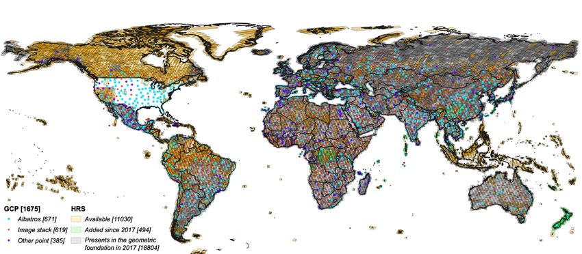
ISPRS Annals of the Photogrammetry, Remote Sensing and Spatial Information Sciences, Volume V-2-2020, 2020
 XXIV ISPRS Congress (2020 edition)

possible to obtain high location performances nearly all over the
world. Figure 10 presents the current geometric foundation
(SPOT 5 HRS imagery and GCP).

3.2.3 BD Amer: a GCP database which facilitates the use of
the geometric HRS foundation

Beyond the exploitation of the HRS images themselves, the
global HRS block may become a reference for adjusting
location models for new images. But, the direct use of the HRS
block for location adjustment is complex and difficult to
manage. Figure 3. SPOT 6/7 image archive overlap count, from 2013 to
 mid-2019 with less than 15% of cloud cover over the image.
Thus, for a long time, the location adjustment of new images
was built with orthoimages (see section 2.1). The innovative 3.3.2 Archive selection and production
BDAmer concept was born in 2009: BDAmer is a GCP
database composed of homologous points extracted on HRS In order to compute the Space Reference Points, more than
images and fully qualified. One strong advantage of this product 400,000 strips (around 30% of the whole SPOT 6/7 archive) are
is that every GCP is seen in stereoscopy (thanks to HRS used. This can be compared with around 20,000 SPOT 5 HRS
instrument), sometimes with a higher multiplicity, and a long strips already input in the geometric foundation. This selection
time interval. All GCP comes with 201x201 pixels multi-view is carefully crafted in order to select the appropriate set of
SPOT 5 HRS chips. This database of 3D points quickly SPOT 6/7 with respect to the SRP production, but also to be
demonstrates its ability to automatically adjust the location of minimal for obvious efficiency reasons. Therefore this selection
VHR images or to perform quality control (Gascon et al., 2017). must enforce these specific constraints:
 – Selecting multi-stereo observations:
In the SRP processing chain, these BDAmer points are used as o Providing images with an overlap count exceeding 6
GCP to refine SPOT 6/7 model location and reach the expected in the production area (usually a whole continent)
accuracy. and ensuring an adequate acquisition angle
 distribution.
3.3 SPOT 6/7 selection and production o Limiting the overlap count to 30 images.
 – Excluding unusable features:
3.3.1 SPOT 6/7 archive
 o Taking into account the cloud mask in the overlap
 count.
SPOT 6/7 satellites are two commercial high-resolution optical
 o Limiting images with seasonal snow coverage.
imaging satellites, part of the Airbus Defence & Space GEO
 o Along coastal areas, selecting images with sufficient
constellation. They offer 4 multispectral bands (R,G,B,NIR) and
 land mass to facilitate the geometric processing.
1.5m resolution imagery in panchromatic mode over a large
 – Avoiding redundant image selection, like ones sharing
60km swath, and up to 600km long. Thanks to their high agility,
 the same acquisition angle, season and year.
the daily acquisition capacity is up to 6Mkm² when operating
simultaneously.
 With these numerous constraints, carrying out such a selection
 at a worldwide scale required the design of specific tools in
Among a large satellite constellation, SPOT 6/7 has been
 order to automate the process and to avoid every time-
chosen as the satellite data which is most adapted to SRP
 consuming step involved in the choice of suitable images. A
constraints: a large swath as per SPOT 5, a resolution rounded
 first “naïve” selection is done using all images with less than
up to 2m sufficient for precise image matching at 20cm (1/10
 15% cloud cover. Then this selection is enforced by the land
pixel), a good variety of acquisition angles for multi-temporal
 mass constraint and the overlap count with respect to the cloud
stereo observations, a plethoric image archive covering around
 cover. In the areas with a weak overlap count, an iterative
50 times the full land mass and acquired with strict monitoring
 process relaxed the cloud cover constraint until the target
of lowest cloud rate. Achieving this first SRP worldwide
 overlap count is reached. Finally, redundant images are
coverage with SPOT 6/7, it is possible that other satellite
 removed. Figure 4 illustrates the benefits of this method on the
mission data may be input in the future.
 image selection for South America. An optimal set of images is
 selected while data efficiency is improved.
The SPOT 6/7 archive contains more than 1.3M strips at the
time this article is written. This archive spans a time range from
 This optimization represents a 12% improvement in data
2013 to 2020, with SPOT 6 acquisitions beginning in 2013 and
 efficiency while the selection of images is more homogenous
SPOT 7 in 2014. The acquisitions are done at a fully world
 and the gaps are almost filled (with the exception of a few
scale, fulfilling Airbus’ customers’ specific needs. In parallel, a
 extreme areas in terms of cloud coverage).
background task images each point of the globe at least once a
year. Figure 3 gives a geographical overview of a subset of this
 The selected images are then effectively produced in full
image archive filtered with less than 15% of cloud cover.
 resolution at sensor geometry level (PRIMARY), panchromatic
 and multispectral (bundle) with a normalized reflectance with
Obviously, in some tropical areas there are no images with less
 respect to Rayleigh diffusion. The whole image production
than 15% cloud cover, yet there are some images with more
 counts for more than 1 petabyte of data and coverage above
clouds in the complete archive.
 2,500Mkm2. Images have been processed at a very high rate and
 then uploaded in an object-store of the cloud platform for SRP
 processing.

 This contribution has been peer-reviewed. The double-blind peer-review was conducted on the basis of the full paper.
 https://doi.org/10.5194/isprs-annals-V-2-2020-15-2020 | © Authors 2020. CC BY 4.0 License. 18
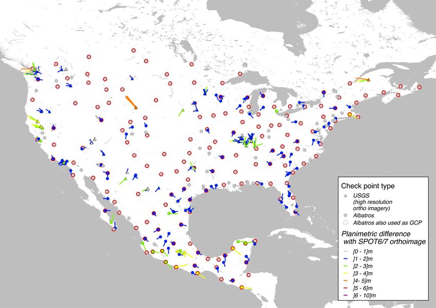
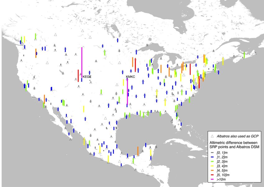
ISPRS Annals of the Photogrammetry, Remote Sensing and Spatial Information Sciences, Volume V-2-2020, 2020
 XXIV ISPRS Congress (2020 edition)

 Type of data Number Storage Size
 (Tb)
 PRIMARY SPOT imagery ≈ 27,000 images Cloud 91
 Subsampled SPOT preview ≈ 27,000 images SRP IT 1,5
 Feature point and GCP 10M points infra- 2,8
 chips structure
 Final SRP including chips 5M points 1,5
 Table 2: Size of the data for the European batch
 Optimized
 selection 3.5 SPOT 6/7 bundle block adjustment

 3.5.1 Tie points

 Feature points are created on SPOT 6/7 imagery according to a
 priority criterion based on cloud coverage, season, freshness,
Figure 4. SPOT 6/7 optimized archive selection with respect to low incidence angle. Ground position of these points is
 cloud cover and acquisition attributes. Left: initial selection computed with the PRIMARY geometric model on the best
 with less than 15% cloud cover over the image. Right: available DSM. Then, image chips can be produced as
optimized selection with a relaxed cloud cover constraint in low described in part 3.4, and a conventional cross-correlation is
overlap count areas and redundant image removal. Colour range performed to get genuine homologous points. A density of
 same as previous figure. 1 point per km2 is designed for SRP specification purposes. A
 subset of tie points is selected for bundle adjustment purposes
3.4 Cloud processing for feature point extraction (corresponding to 100 tie points for a small 60x60km SPOT 6/7
 segment).
Two main processes run directly on the cloud platform on
SPOT 6/7 PRIMARY products. 3.5.2 Ground control point
At the beginning of the processing chain, feature points The usual case implies the use of the BDAmer database as GCP.
candidating to GCP extraction are created thanks to a custom- BDAmer points are located directly in the SPOT 6/7 images
made highly scalable architecture. thanks to the sensor PRIMARY level geometric model. Then,
 an image correlation is carried out between BDAmer and
Classical GCP, collected by survey or picked manually on the SPOT 6/7 images to keep only relevant GCP.
image, are often associated with on-ground paint mark, corner,
intersection, thin pylon, etc. In contrast, the SRP GCP are image In some limited parts of the world, SPOT 5 HRS imagery
chips centred on feature points, computed with classical (consequently BDAmer as well) may not be available. In this
methods as maximum of Hessian value and representing high case, external GCP (as described in section 3.2.2) are measured
peaks of contrast, either bright (common case), or dark spots. directly on two SPOT 6/7 images and then correlated with all
They are particularly adapted to identification by image existing SPOT 6/7 images. The lack of the HRS imagery is
matching processing, rather than human identification, even if compensated thanks to the addition of more GCP, more
the resolution of the destination image is different to the GCP SPOT 6/7 strips, and by ICESat data that improve Z location
image chip. The density of the feature points is set higher than and reliability.
the SRP specification, and much higher than the bundle
adjustment requirement. This large margin allows filtering of 3.5.3 SPOT 6/7 bundle block adjustment and quality
false points while keeping enough good points at the end of the assessment
process. A specific algorithm has been designed to reach a
regular point distribution. Feature points positions are streamed The software used to perform the bundle adjustment is fully
on-the-fly from cloud storage to the SRP IT infrastructure. described in (Massera and al., 2012). A typical check of the
Other data, required for the following processing chain, come remaining equipment of the GCP and tie points (number,
with the points: for each image, a subsampled preview by a distribution, multiplicity and residual values) is achieved.
factor of 10 (used to produce the overview chip) and various Before SRP production, a full bundle adjustment quality
metadata such as the initial geometric model or the cloud mask. assessment is performed thanks to Albatros data and other local
 data when available, not used as GCP in the bundle adjustment.
As explained above, the full resolution images themselves An automatic method has been developed to assess planimetric
remain on the cloud. To achieve the correlation process and the differences between these control data and SPOT 6/7
generation of the SRP image chips, only required image chips orthoimages. Altimetry control is checked by a comparison
centred on feature point and GCP candidates are read from the between the tie point estimated elevation and a reference DSM
cloud. This yields to a massive gain in external data transfer and (Albatros DSM or any other 3D relevant source).
therefore a huge impact on processing time and costs. The table
below shows the amounts involved for the different types of The two figures below show examples of planimetric and
data for the European batch and demonstrates the gain of this altimetric quality check on the North America batch. Colored
workflow organisation. lines represent the differences between SRP and reference data
 (here, Albatros and USGS high resolution orthoimage).
 Obviously, in case of large residuals, further analysis is
 conducted to understand the reason for the differences.

 This contribution has been peer-reviewed. The double-blind peer-review was conducted on the basis of the full paper.
 https://doi.org/10.5194/isprs-annals-V-2-2020-15-2020 | © Authors 2020. CC BY 4.0 License. 19
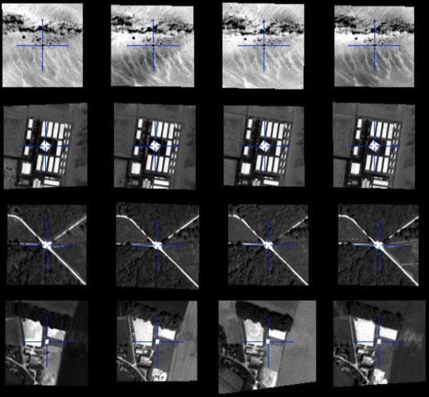
ISPRS Annals of the Photogrammetry, Remote Sensing and Spatial Information Sciences, Volume V-2-2020, 2020
 XXIV ISPRS Congress (2020 edition)

 - A full resolution (2m) image chip set, upon a viewing
 area of 202x202m: one image chip is extracted from
 each qualified SPOT 6/7 measurement. These multi-
 view and multi-date image chips are also able to
 handle seasonal effects on various regions.
 - A single overview image chip at subsampled
 resolution (20m): additionally, one image chip is
 extracted from the most representative image source
 by a 10 sub-sampling factor. The pixel chip size
 remaining the same, it enlarges the GCP viewing area
 of 2020x2020m.

 The image chips are extracts from SPOT 6/7 Panchromatic
 channel in reflectance integer count (104 scale factor). They are
 Figure 5. Planimetric check of SPOT 6/7 bundle adjustment rectified upon WGS84 at a constant ellipsoid altitude, mean
 value from all qualified stereo intersections on the GCP. The
 pixel resolution is normalized in degree unit according to the
 latitude, in order to avoid resampling artefacts. The GCP
 coordinates are those of the chip centre pixel. Image chips are
 formatted in JPEG 2000, lossless compression scheme, and
 encoded with GEOJP2 and GMLJP2 tags.

 The GCP metadata file provides qualified information such as
 georeferencing, geometric accuracy, multiplicity, and lineage.
 Metadata are formatted in XML (ADS DIMAP format). The
 database is spatially organized in a tree data structure,
 partitioning the two-dimensional Earth space along parallels and
 meridians in geographic cells, recursively subdivided into 100-
 degrees, one-degree and 1/100 degree cells.

 The precise matching of the GCP in a destination image is
 recommended with a consequent and relevant image chip set for
 Figure 6. Altimetric check of SPOT 6/7 bundle adjustment multi-view observations. This will suppress outliers, refine the
 KEGE and KMKC airports high altimetric differences are due exact location, and offset off-nadir effects, resolution scaling
 to changes between Albatros Pléiades and SPOT 6/7 (airport and other deformations on the real shape of the feature in the
 duel tank), both data are correct destination image. For a fast registration, or to register
 destination image with poor native location, the matching may
3.6 SRP production be initiated with the GCP overview single-view chip.

3.6.1 SRP generation and format delivering Perennial and freshness of the SRP database could be assumed
 by an update process, scanning the new acquisitions of the
The final product is then built, if necessary, after a specific image satellite archive.
quality process, as presented in section 3.6.2.
 3.6.2 Improvement for complex landscapes
Each GCP gathers one metadata file and an image chip set, GCP
being at the centre. In some specific landscapes, a fraction of the feature points
 automatically extracted may represent non-perennial objects.
 When this phenomenon is detected (thanks to BDAmer
 experience or during quality check), specific processing is
 performed. Two user cases are described in this section.

 − Manual filtering on coastal regions

 Coastal regions are prone to unsuitable points such as specular
 effects on waves or moving boats. Thanks to a first automatic
 selection with water bodies’ information, browsing is performed
 by operators in order to manually filter remaining errors.

 − Deep learning filtering on desert areas

 In the case of large deserts with sand dunes, detected feature
 points are often extracted on the dune peak or cavity (Figure 8,
 left, in red). Those points are not reliable since, in certain
 Figure 7. Examples of 3 GCP SRP points with 4 image chips regions of the world, dunes may move up to 100 meters per
 year.
There are two types of image chips at a fixed size of 101x101
pixels:

 This contribution has been peer-reviewed. The double-blind peer-review was conducted on the basis of the full paper.
 https://doi.org/10.5194/isprs-annals-V-2-2020-15-2020 | © Authors 2020. CC BY 4.0 License. 20
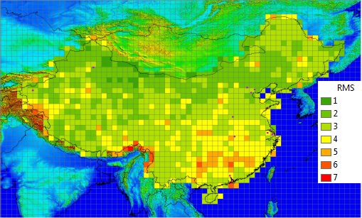
ISPRS Annals of the Photogrammetry, Remote Sensing and Spatial Information Sciences, Volume V-2-2020, 2020
 XXIV ISPRS Congress (2020 edition)

The Rub’ al Khali in the Arabian Peninsula is a sand desert WD4O V2 is a hybrid DTM/DSM derived from the WorldDEM
which covers 650,000km2. Former experience with HRS DSM which fulfills Level 1 of the NGA High Resolution
imagery and BDAmer database shows that in this case, many Elevation Product specification (NGA, 2020). WD4O have an
feature points occur on moving dunes. Yet, some good details absolute vertical accuracy specification of < 4m LE90 and a
can still be found: rock outcrop, plants described in (Ghazanfar relative specification of < 2m LE90 on slopes < 20%.
and Fisher, 2013) or anthropic objects (see Figure 8, right, in
green). At first, the global quality of elevation values from SRP points
 toward WD4O was assessed. The absolute difference between
 WD4O and SRP elevation values was computed on areas
 supposed to share a similar on-ground reference surface. The
 results were statistically agglomerated, and elevation RMS was
 computed at degree size square cell (see Figure 9). Because of
 differences of covering along the China borders and shorelines,
 statistics may not be reliable and some artefacts may occur.
Figure 8. Feature points on desert: dunes (red) and other (green)

A method based on a deep learning classification algorithm has
been developed to automatically detect dune points, and was
applied on the Rub’ al Khali desert. A training dataset of 5122
samples was built up manually (representing 1,8% of the entire
dataset) and used in a typical convolutional neural network
based on VGG16 (Simonyan, K., Zisserman, A, 2014). For each
point, the algorithm provides a probability of belonging to a
given class. To ensure the best reliability, the 9% of the points
classified with a low confidence were shown to an operator for
review. Quality control, conducted on a randomly selected
subset of 25,084 points all over the area, shows 10% errors.
This is a satisfying result, on par with human performance.

 4. PERFORMANCE ASSESSMENT Figure 9. China, RMS elevation difference (m) between SRP
 points and WD4O V2 DTM/DSM
4.1 Proof of concept on Spain site
 Most measurements range between 1 and 4m, denoting a good
In 2017, an early proof of concept was established on Spain. consistency and rigidity of SRP data. Higher differences in the
This country was chosen for its consequent size and various south-east part of China may be explained by large forested
landscapes (urban, rural, mountainous, wild nature…). A areas where DSM and SRP may represent the reference surface
prototype of first rough SRP database was used on 11 different differently. Future works are on-going to deeper demonstrate
test sites to refine on each site the 3D sensor model of the SRP elevation quality including with ICESat-2 data.
Pléiades HR stereo images. The Spanish National Program for
Aerial Orthophoto (PNOA) with an accuracy estimated at Secondly, the refined image planimetric accuracy has been
1m CE90, see (Villa, 2007), was used as independent assessed on 8 different sites using Pléiades 1A/1B 50cm single
planimetric check points (see Table 3). image (see Table 4). Accuracy of both check sources is
 1m CE90 or better.
 Check points XY
Test site Landscape
 residues (CE90, m) Test site Landscape Pléiades Check Ortho quality
Alcaniz Barren landscape 3.0 incidence points XY check
Aragon Barren landscape 3.0 angle residues (absolute
Asturias Medium mountain, dense vegetation 1.6 (degree) (CE90, m) CE90, m)
Barcelona Urban, coast, hilly 3.0 Wuhan Rural, water areas 13.8 2.2 2.5
Estremadure Field crops 3.0 Kashgar Rural, semi-desert 15.8 3.2 2.4
Huesa Medium mountain, poor vegetation 3.6 moderate mountain
Madrid Urban 2.6 Shenzhen Urban, mountain 16.0 2.0 2.8
Salamanque Field crops 2.6 Beijing Urban, highlands 16.8 1.5 1.8
Santander Urban, coast, hilly 1.7 Macau Urban, isolated 18.2 1.7 4.1
 mountain
Valladolid Urban 2.3
 Urumqi Rural, semi-desert 20.1 1.6 1.8
Valencia Urban, crop fields 2.1
 mountain
 Table 3. Accuracy assessment on Spain test sites Zhengzhou Rural 19.7 3.0 2.2
 Shanghai Urban, highlands 22.6 2.5 3.9

Results on this SRP prototype were around 3mCE90, Table 4. Accuracy assessment on China test sites
demonstrating such level of specification could be targeted for a
final SRP product. Independent control points are introduced to check the bundle
 adjustment accuracy (XY residues). Airbus Albatros airport
4.2 Real performance assessment on China orthoimages (see section 3.2.2) are used to check the final
 orthoimages rectified with WD4O. The 5m CE90 planimetric
In 2019, a campaign was performed to assess the planimetric accuracy for single orthoimagery is largely achieved. These first
performance target of 5m CE90 for standard orthoimagery: the results will be consolidated in the future.
sensor model was first adjusted on SRP GCP and then rectified
with WorldDEM4Ortho (WD4O). The SRP final product and
WD4O V2 data over China were used.

 This contribution has been peer-reviewed. The double-blind peer-review was conducted on the basis of the full paper.
 https://doi.org/10.5194/isprs-annals-V-2-2020-15-2020 | © Authors 2020. CC BY 4.0 License. 21
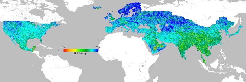
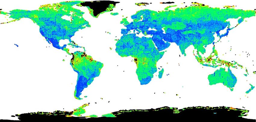
ISPRS Annals of the Photogrammetry, Remote Sensing and Spatial Information Sciences, Volume V-2-2020, 2020
 XXIV ISPRS Congress (2020 edition)

4.3 Performance of SRP for images with poor native isolated islands would probably require new optimizations.
location Work is already in progress to reach the best possible accuracy.

As explained above, every SRP point goes with one subsampled With benefits from twenty years of common work and
overview chip in order to handle destination images with poor experience shared between IGN and ADS, the SRP database
native image location. An experiment was carried out on two offers a worldwide, accurate and straightforward registration
different datasets to validate this concept. On these test sites, a service for various images. Such a service can target a location
direct SRP registration of Pléiades images was performed and accuracy of 3m for the sensor model and a horizontal
compared with: performance of 5m for orthoimages in a massive standard
 − Simulated poor location (0): attitudes were moved process. SRP is an evolving concept that can easily be upgraded
 randomly in yaw/pitch/roll, thus initial location moved with new images, ensuring a potential infinite up-to-dateness.
 by approximately one or a few hundred meters.
 − Coarse registration (1): images are registered on the SRP
 only with the subsampled chips. REFERENCES
 − Fine registration (2): images are registered with the full-
 resolution chips. It is expected for this location to be Airbus, 2020. Pléiades Neo Trusted Intelligence.
 close to the direct location. https://www.intelligence-airbusds.com/en/8671-pleiades-neo-
 trusted-intelligence (23 January 2020).
The table below shows that similar results can be reached for
the two datasets on Spain. Airbus, 2020-b. WorldDEM4Ortho.
 https://www.airbus.com/newsroom/press-
Differences with SRP Valencia Galicia - test1 Galicia - test2 releases/en/2017/07/airbus-releases-worlddem4ortho--the-most-
registration (meter) dX dY dX dY dX dY accurate-elevation-mode.html (23 January 2020).
 0. Simulated poor
 -130.9 101.0 -123.3 184.0 -204.2 216.3
 location Bouillon A., Bernard M., Gigord P., Orsoni A., Rudowski V.,
 1. Coarse registration
 (overview single-view -0.6 -1.3 -0.1 0.7 -0.8 -3.4
 Baudoin A., 2006. SPOT 5 geometric performances: Using
 chips) block adjustment as a key issue to improve quality of DEM
 2. Fine registration generation. ISPRS Journal of Photogrammetry & Remote
 (full resolution multi- 0.1 0.0 0.1 0.0 0.1 -0.4 Sensing 60 (2006) 134-136.
 view chips)
 Table 5. Performance of SRP for images with poor native Breton, E., Orsoni, A., Lasselin, D., Pausader, M., 2009. Ready
 location to use solution to give a boost to African countries’ base maps.
 IGN, Institut Géographique National. Africa GIS Conference,
 5. ON-GOING PRODUCTION AND CONCLUSION Kampala, Uganda 2009.

5.1 Results at mid-term project Gascon, F., Bouzinac, C., Thépaut, O., Jung, M., Francesconi,
 B. et al., 2017. Copernicus Sentinel-2A Calibration and
The complete workflow is operational since March 2018. More Products Validation Status. Remote Sensing, MDPI, 2017, 9 (6),
than 47Mkm2 (Europe & Turkey, West Russia & Middle East, pp.1-81. 10.3390/rs9060584. Hal-01853316
North America & Mexico, East Continental Asia) were
produced from the beginning of the project in March 2018, to Ghazanfar S.A, Fisher, M., 2013 : Vegetation of the Arabian
September 2019. 57Mkm2 (Africa, Australia and South and Peninsula, Springer Science & Business Media
Central America) are currently in progress (February 2020).
 Massera, S., Favé, P., Gachet, R., Orsoni, A., 2012. Toward a
On the 47Mkm² already produced: global bundle adjustment of SPOT 5 – HRS Images. Int. Arch.
 - GCP density reached satisfies the expected Photogramm. Remote Sens. Spatial Inf. Sci., XXXIX-B1, 251-
 specifications as shown in Figure 11: 91.7% of 1/100 256, doi.org/10.5194/isprsarchives-XXXIX-B1-251-2012.
 degree geocell fulfil the 1 point per 2km2
 specification. As expected, density is sometimes NGA, 2009. Implementation Profile for High Resolution
 relaxed in typical difficult landscapes (snow, sandy Elevation (HRE) Products. Version 1.0.
 desert, areas with persistent cloud,…). https://nsgreg.nga.mil/NSGDOC/files/doc/Document/NGA.IP.0
 - GCP accuracy is also in accordance with the 002_1.0%20HRE.pdf, (23 January 2020)
 3m CE90 specification since it has been estimated
 with Albatros data at 2.6m CE90. Simonyan, K. and Zisserman, A., 2014. Very Deep
 Convolutional Networks for Large-Scale Image Recognition.
On the 57Mkm² currently in progress, work has been carried out arXiv preprintarXiv:1409.1556.
to improve SRP density on frequently cloudy regions (tropical
climate), see section 3.2, “relaxed cloud cover constraint”. SPOT Image, 2011. Reference3D Product Description. Version
 6.1. https://www.intelligence-
5.2 Conclusion airbusds.com/files/pmedia/public/r469_9_reference3d_product_
 description_201105.pdf, (23 January 2020)
In January 2020, the Space Reference Point workflow has a
production background of nearly 100Mkm². The next batches
 Villa, G., 2007. PNOA (Spanish National Program for Aerial
on high latitudes (low anthropic, snow cover), scattered and
 Orthophoto): collaborative and innovative spirit in Spanish
 geospatial information. Geoinformatics.

 This contribution has been peer-reviewed. The double-blind peer-review was conducted on the basis of the full paper.
 https://doi.org/10.5194/isprs-annals-V-2-2020-15-2020 | © Authors 2020. CC BY 4.0 License. 22
ISPRS Annals of the Photogrammetry, Remote Sensing and Spatial Information Sciences, Volume V-2-2020, 2020
 XXIV ISPRS Congress (2020 edition)

 Figure 10. Geometric foundation – January, 2020

 Figure 11. SRP density status – September, 2019

This contribution has been peer-reviewed. The double-blind peer-review was conducted on the basis of the full paper.
 https://doi.org/10.5194/isprs-annals-V-2-2020-15-2020 | © Authors 2020. CC BY 4.0 License. 23
You can also read