CHALLENGING THE INVISIBILITY OF MOBILE CULTURES REMOTE SENSING, ENVIRONMENT AND ARCHAEOLOGY IN THE NEAR EAST - ISPRS Archives
←
→
Page content transcription
If your browser does not render page correctly, please read the page content below
The International Archives of the Photogrammetry, Remote Sensing and Spatial Information Sciences, Volume XLII-2/W11, 2019
                 GEORES 2019 – 2nd International Conference of Geomatics and Restoration, 8–10 May 2019, Milan, Italy

             CHALLENGING THE INVISIBILITY OF MOBILE CULTURES
      REMOTE SENSING, ENVIRONMENT AND ARCHAEOLOGY IN THE NEAR EAST

                                        M. Silver¹, M. Törmä², K. Silver³, M. Nuñez¹, J. Okkonen¹

                       ¹University of Oulu, Pentti Kaiteran katu 1, 90014 Oulu, Finland – minna.silver@helsinki.fi
                                           ²Aalto University, Finland, ³Independent researcher

KEY WORDS: Remote sensing, satellite imagery, environment, archaeology, mobile cultures, GIS, landscape modeling

ABSTRACT Remote sensing has provided a modern wider perspective to approach the earth with its various environments and impact of
humans by prospecting previously unknown frontiers of human life. The traces of mobile groups are archaeologically often more difficult
to detect than those of the sedentary ones, but new approaches and methods have changed and enhanced the ways to extract
archaeological information of hunter-gatherers and pastoral nomads. Remote sensing, for example, provides alternative views from above
and better visibility in a larger scale, especially with high resolution solutions, than on the ground to trace sites. Mobile people have
become more visible in archaeology, and therefore their importance in the development of human cultures has received more focus and
understanding. This paper will focus on the use of remote sensing in the archaeological study of mobile cultures and their environments in
the Near East. Various examples of techniques and site types will be discussed, and the suitability of applications will be considered
based on the studies by Finnish and Finnish-Swedish projects in the Near East. We will provide examples of applications and emphasize
the importance of empirical approaches in studying archaeological evidence by remote sensing. GPS coordinate points have served as the
basis of our field survey and mapping. From the image-based data we shall deal with aerial photographs, CORONA satellite photographs,
Landsat, SPOT, QuickBird and GeoEye satellite images. From the range-based data we shall discuss X-SAR Shuttle Mission 2000 and
ASTER-DEM data, but LiDAR and geophysical devices will only be briefly considered.

                      1. INTRODUCTION                                  Identifying remains of mobile cultures is important because
                                                                       mobility has governed the human past much longer than the
Archaeology of mobility has particular challenges, because of the      sedentary ways of life. Today archaeology of mobility also offers
ephemeral nature of many types of remains hunter-gatherers             avenues for studying migrations and the material signs they might
andpastoral nomads leave behind. (See, e.g., Wendrich and              leave behind (see, e. g., Burmeister 2000; Rouse, 1986). From the
Barnard, 2008). This does not mean that all the remains have been      beginning the humans participated in great diasporas that can be
lost but that there are challenges to detect the preserved ones.       nowadays tracked by DNA (Cavalli-Sforza, 1996; Oppenheimer,
During the past decades new technologies and methods of                2004).
inquiries have enhanced prospecting and studying the mobile
cultures (see Silver, 2016b). They have provided new ways to
extract information of these cultures and make them more visible
in the archaeological record. Remote sensing, for example, has
provided large scale views and new devices, data, programs and
software attaining better resolutions for prospecting unknown
frontiers and signs of human life and sites of dwellings. Actually,
one of the first great discoveries by satellite archaeology was
Ubar, a caravan city of mobile people in Oman ( see Lem, 2017).

Archaeology provides the longest perspective in studying human
cultural impact on earth. It opens a possibility to a long-term view
in approaching the relation of humans with their environment.
With remote sensing studies the modern technological world
meets the ancient one. The Near East forms a bridge between             Figure 1. A topographic map showing the Bishri block in Central
different continents and has provided the evidence of movements             Syria in the left corner below. Courtesy: M. Baranzangi
of people over the millennia. By using aerial photography, satellite
images and radar data we can zoom in and study the environment         This paper brings up different data sources in remote sensing and
of the region and traces of humans.                                    how they can be applied in studying mobile cultures. The benefits
                                                                       of remote sensing also lie in the fact that remote sensing provides
As far as the time scale of the human way of life on earth is          non-invasive methods. The Finnish project SYGIS prospected by
concerned, its longest period pertains to mobility, i.e., hunter-      old aerial photographs and recent satellite imagery remains of
gatherers and later pastoral nomads. They represent cultures that      hunter-gathers and pastoral nomads in the mountainous region of
have had an intimate relationship with the environment.                Jebel Bishri belonging to the Palmyrides in Central Syria (Fig. 1)
                                                                       in a desert-steppe environment in 1999/2000–2010 (see Lönnqvist

                                                  This contribution has been peer-reviewed.
                    https://doi.org/10.5194/isprs-archives-XLII-2-W11-1065-2019 | © Authors 2019. CC BY 4.0 License.              1065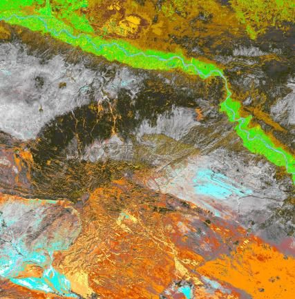
The International Archives of the Photogrammetry, Remote Sensing and Spatial Information Sciences, Volume XLII-2/W11, 2019
                 GEORES 2019 – 2nd International Conference of Geomatics and Restoration, 8–10 May 2019, Milan, Italy

et al., 2011), and such prospecting can still be carried out from a   Coordinates can also be attained from satellite image data. In a
desktop despite of the civil war in Syria.                            period of the past decade GoogleEarth enhanced its spatial
                                                                      resolution and offered more possibilities to record coordinates, but
But observing archaeological sites and structures by remote           the image data that it offers is not comparable to tesselated
sensing from air and space needs empirical testing on the ground      satellite images that bear huge amount of numeric data and can be
either by surveying or excavating to secure the right understanding   used for various types of GIS (Geographic Information Systems)
of the nature of remains. SYGIS carried out field surveys on the      analyses. Declassified CORONA satellite photographs (when
ground in Syria, also using geophysical devices reveal subsoil        digitized provide up to 1.8 m in spatial resolution) was the
features but requires excavation for the identification of remains.   cheapest alternative for using higher resolution satellite data
There have been misinterpretations in the past on the nature and      sources thanks to their release to open market, and we used them
age of discoveries by only making conclusions based on remote         since 2003. They needed digitizing and to be rectified to be used
sensing. The ground survey or an excavation can finally               in a particular coordinate system. But nowadays one can acquire
empirically bring confirmation of the nature and age of the site.     them readily digitized.

              2. RECORDING COORDINATES                                However, the satellite images such as QuickBird images (0.6 m
                                                                      spatial resolution) and GeoEye images (0.46 m spatial resolution
For archaeology the knowledge of the location of a site or a          in panchromatic channel), offer the highest spatial resolution that
structure is of utmost importance. It is an identifier of a site.     has been available in commercial market. We have used all these
Coordinate information should be collected in all archaeological      satellite data sources in various ways in order to find answers to
studies, as coordinates are scientific and unambigious parameters     scientific questions both in Syria and in Turkey (see Lönnqvist et
providing exact information of a site location on earth. UNESCO,      al., 2011; Silver et al., 2017). Here we only deal with the questions
for example, publishes such geographic coordinates as the central     that are pertaining to hunter-gatherers and pastoral nomads
coordinate of the site and boundary points of its visible or          respectively. We used geophysical devices such as Ground
otherwise known borders (www.whc.unesco.org: document -               Penetrating Radar (GPR) (Lönnqvist et al. 2011) studying alluvial
coordinates).                                                         terraces for grazing ground and tomb sites of pastoral nomads.

Obtaining coordinate information is the first step in the recording   Three-dimensional recording (x, y and z) has been used in
and protection of a site. It is also needed for GIS (Geographic       archaeology over a hundred years. Stereophotographs brought
Information Systems) (see Lönnqvist and Stefanakis, 2009) that        three-dimensional ways to document sites already in the end of the
was used in the Finnish project SYGIS: the UTM coordinate             19th century, also in the Near East (Silver, 2016). With modern
system was applied in the project. GPS (Global Positioning            technologies SYGIS continued in recording, documenting and
System) was primarily used for recording the location of              modeling sites and landscapes in 3D (Lönnqvist et al., 2012).
archaeological sites and structures on the ground. GPS was also       Nowadays LiDAR (Light Detection and Ranging technique),
used on the ground to collect waypoints. For Landsat-7 ETM            terrestrial laser scanners and 3D cameras can be used, if the
images we also still needed to collect control points with a GPS on   budget allows, but they were not available yet or not in our reach
the ground in order to orthorectify the images, and then the          nearly twenty years ago. SYGIS applied a total station for
panchromatic channel of Landsat-7 providing 15 m spatial              recording and documenting sites and small finds in detail (Fig. 3).
resolution was used for mapping with MapSheets Express                Photographing was carried out using both a digital and analogue
software (Figure 2). It offered means for prospection and map         cameras for documentation in situ. Site sheets were kept for
sites more in detail than the cartographic data that was available.   recording. (Lönnqvist et al., 2011).
(Lönnqvist et al., 2011)

                                                                      Figure 3. Detailed recording of Palaeolithic workshops with total
                                                                      station and a prism at Tar al-Sbai on Jebel Bishri. Photo: SYGIS
                                                                      2000.

                                                                                       3. REMOTE SENSING
                                                                                 ENVIRONMENTS OF THE ANCIENTS
Figure 2. Mapping some major sites using the panchromatic
channel of Landsat-7 ETM and MapSheets Express software as            As remote sensing by aerial photographs, satellite images and
well as locating a survey area at the river edge with ASTER-          radar data such as included in LiDAR opens an access to visibility
DEM data. Mapping by M. Lönnqvist (present Silver) 2006.              from above, these data enable approaches on a larger scale.

                                                  This contribution has been peer-reviewed.
                    https://doi.org/10.5194/isprs-archives-XLII-2-W11-1065-2019 | © Authors 2019. CC BY 4.0 License.               1066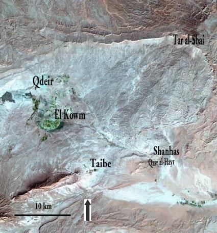
The International Archives of the Photogrammetry, Remote Sensing and Spatial Information Sciences, Volume XLII-2/W11, 2019
GEORES 2019 – 2nd International Conference of Geomatics and Restoration, 8–10 May 2019, Milan, Italy
Therefore, the data sources are also used for cartographic We have used Landsat-7 ETM and SPOT satellite imagery for
purposes. Satellite images provide information of biotic patterning environmental studies. Landsat-7 was also used for landscape
to evaluate resource bases for human living, the information that modeling and cluster analyses that reveal the contrast of the
can be matched with topographic and sedimentary data. This data environment and particular features. Radar data from X-SAR
can be used in for prospecting and planning a ground survey or Shuttle Mission 2000 was applied to create landscape models by
analysing site locations. (Butzer, 1982, 8). Both hunter-gatherers fusing Landssat-7 ETM image data. Radar data was received from
and pastoral nomads have been dependant in their lifestyle and the German Aerospace Centre in DEM tiles as SYGIS was
movement on seasonality. accepted into NASA’s world monitoring program in 1999. That
has also offered possibilities to carry out visibility analyses from
Especially the areas such as steppe and desert regions, typical for Tar al-Sbai on Jebel Bishri occupied both by prehistoric hunter-
the Near East, are arenas for hunter-gatherers and pastoral gatherers, and pastoral nomads that lived during the prehistoric
nomads. They also are favourable environments for studies and and historic times in the area. (Lönnqvist et al., 2011)
analyses by satellite imagery because there are no thick vegetation
covers or cloudy conditions for much of the year. LiDAR can A palaeolake became detectable on Jebel Bishri by executing
reveal sites and structures under vegetation, even in wooded areas cluster analysis with Landsat-7, although the lake was initially
(Silver, 2016a). Nowadays, however, there are a number of detected on the ground in 2004. Several prehistoric sites were
principles in remote sensing to distinguish vegetation patterns that recorded on the shores of the lake. (Lönnqvist et al., 2011, 109)
indicate archaeological sites (Brooks and Johannes, 1990, 142–
152). For example, different seasons of the year and times of a day
provide varied information in aerial photographs and satellite
imagery, such as features of ancient sites in different day-lights or
potential for land use such as grazing. We shall in due course
discuss the application of such an approach to study grazing
potential in steppe areas.
Jebel Bishri is a mountainous area of contrasts as it is steppe-
desert receiving less than 200 mm annual rainfall. The area is
limited and therefore associated with the Euphrates river valley,
and the subsistence economies are divided according to the
environment. During the Pleistocene the climate of the region was
obviously less arid and the landscape more savannah-type, but the
trees have disappeared apart from some small favourable pockets
and plantations. However, a continuous forest cover never reached
the area during the Holocene. The steppe-desert environment
provides opportunities for pastoral nomadism, and the river valley Figure 5. A landscape model showing the Euphrates river valley
with its irrigation systems for sedentary life and agriculture. and Jebel Bishri in Syria produced by fusing X-SAR shuttle
(Lönnqvist et al., 2011). mission 2000 DEM data with Landsat-7 ETM image data.
Constructed by M. Törmä 2003.
Figure 6. The cluster analysis of the vegetation cover of Jebel
Bishri carried out by using Landsat-7 ETM image. The palaeolake
area is encircled in white. Analysis by M. Törmä 2004.
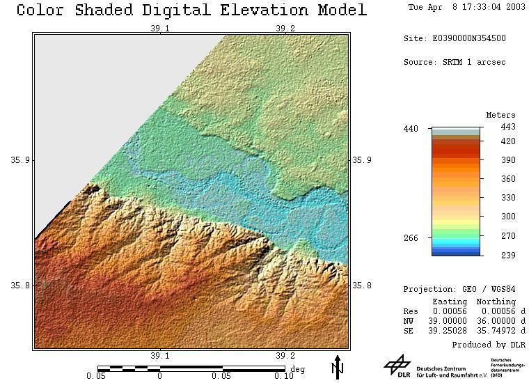
Figure 4. DEM tile from X-SAR shuttle mission 2000 showing
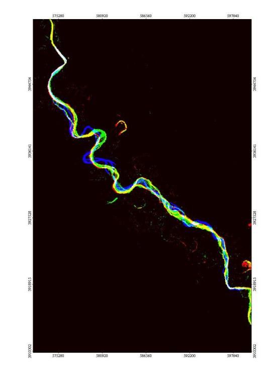
parts of Jebel Bishri and the Euphrates river valley. The data was River channel changes of the Euphrates were also analysed using
provided German Aerospace Centre. CORONA satellite photographs and Landsat images from various
years over decades. It is possible that some ancient sites have
This contribution has been peer-reviewed.
https://doi.org/10.5194/isprs-archives-XLII-2-W11-1065-2019 | © Authors 2019. CC BY 4.0 License. 1067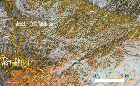
The International Archives of the Photogrammetry, Remote Sensing and Spatial Information Sciences, Volume XLII-2/W11, 2019
                 GEORES 2019 – 2nd International Conference of Geomatics and Restoration, 8–10 May 2019, Milan, Italy

submerged under silts. However, we detected several prehistoric         For example, the areas between Jebel Bishri and El Kowm are
sites on the river terraces (Lönnqvist et al., 2007, 465–470).          littered with Palaeolithic tools (Fig. 8). This, however, opens a
                                                                        window to a time scale that we are dealing with. El Kowm is an
It needs to be stated that the sedimentation in desert and steppe       oasis that has provided finds going back to one million years, and
areas is relatively slow, and sites can sustain on the surface for      the tools in the piedmonts and valleys are mainly from the Middle
thousands of years. We observed this at prehistoric sites.              Palaeolithic period and represent life in tens of thousands of years.
Workshops for tools that were tens of thousands of years old were       (See Lönnqvist et al., 2012). Beside tools or other small finds rock
left behind as if they had been left yesterday. But, if subsoil         paintings and drawings are not detectable even with high
studies are applied, remote sensing by geophysical devices can be       resolution satellite imagery.
used in prospecting and surveying to detect walls, house floors,
pits, tombs, embankments, ditches and roads (Butzer, 1981, 159).
For searching pastoral nomadic sites metal detectors can also be
used. Tent sites often include such material.

                                                                        Figure 8. The oasis of El/Al Kowm on the western piedmont of
                                                                        Jebel Bishri and Tar al-Sbai, a semi-circular escarpment of the
                                                                        mountain visible in Landsat-7 ETM. ©EurImage. Mapping by M.
                                                                        Lönnqvist (present Silver) 2009.

Figure 7. Euphrates channel changes mapped from various
satellite images by M. Törmä 2007

Drought increases mobility both among hunter-gatherers (Bird and        Figure 9. Collapsed Palaeolithic abris at Jebel Bishri. Photo: J.-P.
Bird, 2005, 85) and pastoral nomads. We have studied the effect         Matar 2000.
of desertification by analysing the movement of the desert line
using satellite imagery from various. The large veil of sand had        The kinds of remains of hunter-gatherers that remote sensing with
expanded significantly between 1990 and 1999 due to increased           aerial photographs and satellite imagery can be traced consist of
desertification that has affected the livelihood of pastoralists.       rock shelters, hut bases and kites (large animal traps used for
(Lönnqvist et al., 2010, 2011).                                         gazelle hunting). Those can be detected in the regions of Jebel
                                                                        Bishri. Rock shelters can be assumed from the shapes of mountain
             4. SITES OF HUNTER-GATHERERS                               edges, and their relation to known prehistoric sites like El Kowm
                                                                        in our case. Tar al-Sbai is a semi-circular escarpment of Jebel
Hunting and gathering is the earliest mode of human life and has        Bishri situated in its western side. We were able to experimentally
been present since the Palaeolithic times. There are also hunter-       confirm that there indeed are Paleolithic abris the roof of which
gathers in present-day native tribes in different parts of the world.   have collapsed due to heavy erosion in the region (Fig. 9). On the
The sites that represent the hunter-gatherer phase especially create    ground we also found a number of crescentic hunting blinds (Figs.
a challenge for detection by aerial photographing and satellite         10 and 11) constructed of field stones at the edge of the mountain.
image prospecting as they do not provide enough resolution to           The area offered great visibility to the plains and enabled
distinguish open-air sites and the dispersion of small tools on the     observance of gazelle movements. All the identified sites were
ground. But in the case of the autonomous vehicles, such as             recorded by a total station on the ground. From here we carried
drones, aerial photographs and LiDAR can even reach the needed          out the mentioned visibility analyses to the plains and have
resolutions.

                                                   This contribution has been peer-reviewed.
                     https://doi.org/10.5194/isprs-archives-XLII-2-W11-1065-2019 | © Authors 2019. CC BY 4.0 License.                1068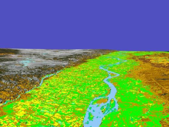
The International Archives of the Photogrammetry, Remote Sensing and Spatial Information Sciences, Volume XLII-2/W11, 2019
                 GEORES 2019 – 2nd International Conference of Geomatics and Restoration, 8–10 May 2019, Milan, Italy

discussed the landscape models elsewhere (Lönnqvist et al.,            For example, Göbekli Tepe, situated in southeastern Turkey close
2012).                                                                 to the city of Urfa, is an imposing structure of hunter-gatherers
                                                                       inscribed into the UNESCO World Heritage Sites. It is the site of
                                                                       the so-called world’s oldest temple that Klaus Schmidt’s
                                                                       excavations discovered in 1995 based on earlier surveys. The site
                                                                       dattes back to the Early Neolithic period (the 10th and 9th millennia
                                                                       BC) and has been a challenge for restoration and conservation.
                                                                       (Schmidt, 2012). New subsoil evidence of extra curvilinear
                                                                       enclosures have been identified by remote sensing at site using
                                                                       geophysical devices (Dietrich et al., 2012). In addition, an
                                                                       aboriginal natural monument of Uluru-Kata Tjuta in Australia is
                                                                       one of the exceptions of hunter-gatherer sites in its size. It is also a
                                                                       UNESCO World Heritage Site, and an information system has
                                                                       been developed for it using aerial images of the site (courtesy of
                                                                       the information from C. Ogleby 2008).
Figure 10. A hunter’s blind. Photo: M. Stout Whiting 2000.
                                                                                     5. SITES OF PASTORAL NOMADS

                                                                       To the pastoral technocomplex Southwest-Asian Arid Zone Juris
                                                                       Zarins (1992) has included also kites and such structures as
                                                                       cairns/tumuli and stone circles of various kinds. We recorded
                                                                       cairns/tumuli and stone circles that could be detected on
                                                                       QuickBird images, and surveyed a number of such structures on
                                                                       the ground. GPR studies were also carried out to trace pastoral
                                                                       tombs (Fig. 13) Kites were used in the Stone Age, but also
                                                                       pastoralists have been using them up until recent centuries
Figure 11. Recording Paleolithic abri sites and hunters’ blinds at     (Crassard et al., 2014). Jebel Bishri is especially associated with
Tar al-Sbai using a tachaeometre. Measurements by M. Saario and        gazelle routes and such traps exist in the local pastoral nomadic
Donald Lillqvist 2000, computer mapping by J. Okkonen.                 environment. In addition, we could like to add wells that can also
                                                                       be included in the pastoral technocomplex and for which we made
                                                                       distribution maps (Lönnqvist et al., 2011).

Figure 12. 3D scene of mosaic of Landsat-4 MSS images 172/35
and 36 taken 12.7.1983, channels 574 from south to north at Tar
                                                                       Figure 13. Studying tumuli of pastoral nomads on Jebel Bishri by
al-Sbai. Constructed by M. Törmä 2006.
                                                                       GPR. Analyses by J. Pedrez-Rodes.
Hut bases could be recognized by aerial photographs and satellite
                                                                       There is and has existed different degrees of nomadism among the
images with high spatial resolution. This we have noticed while
                                                                       pastoralists living in the region: some have been more nomadic
carrying out and finding possibilities to detect those remains with
                                                                       than the others. Evidence of year-round mobility was detected
the help of satellite imagery. GoogleEarth can be used for initial
                                                                       among some pastoralists in the mountain and its piedmont
prospecting, but, as mentioned, for GIS analyses it opens limited
                                                                       plateaus. However, generally semi-nomadism and semi-sedentary
possibilities. Our personal studies have provided information
                                                                       pastoralism, also the latter related to transhumant pastoralism, are
concerning the application of QuickBird. Spatial resolution of
                                                                       typical modes of nomadism in the region. Transhumance is
QuickBird (0.6 m) and nowadays GeoEye (0.46 m in
                                                                       vertical nomadism between high- and lowlands. (See Khazanov,
panchromatic channel) provide enough spatial resolution to study
                                                                       1994; Lönnqvist, 2014).
structures such as hut bases (see Lönnqvist et al., 2011; Silver et
al., 2017).
                                                                       Textual evidence from the cuneiform sources associates Jebel
                                                                       Bishri with pastoral nomads and tribal people. In the Bronze Age
There are also exceptions like natural monuments and temples of
                                                                       cuneiform sources they are identified as Amorites (3rd to 2nd
hunter-gathers that are known to be more visible than regular sites.

                                                  This contribution has been peer-reviewed.
                    https://doi.org/10.5194/isprs-archives-XLII-2-W11-1065-2019 | © Authors 2019. CC BY 4.0 License.                   1069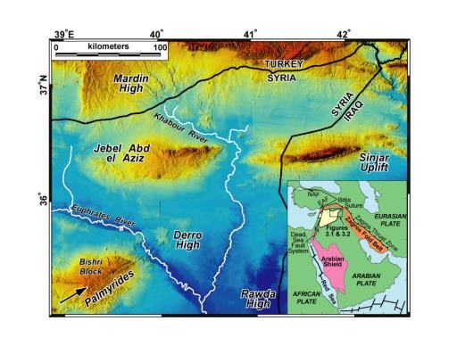
The International Archives of the Photogrammetry, Remote Sensing and Spatial Information Sciences, Volume XLII-2/W11, 2019
                 GEORES 2019 – 2nd International Conference of Geomatics and Restoration, 8–10 May 2019, Milan, Italy

millennium BC) and in the Iron Age (late 2nd millennium to 1st          Bishri covering 8 km x 8 km served as a basis in prospecting for
millennium BC) as Arameans whose existence (see the references          corral sites used by pastoral nomads. Because of the high spatial
in Lönnqvist et al., 2011) continued to be known in the Roman           resolution of the images (0.6 m), flimsy structures left by mobile
period. Still Aramaic minorities, also known as Syriac people, are      societies, typical of the area, have been traced, located and
known especially in Syria and Turkey.                                   recorded by the remote-sensing methods. Stone-built corrals are

But the Arab Bedouins came into the picture from the Iron Age,
and they still continue to live in the Jebel Bishri region and the
Syrian Desert. Their ways of lives have been recorded over a few
centuries (see, e.g., Bell, 1908; Lewis 1987) and also studied by
ethnoarchaeological means as well. Present-day Bedouin tents can
be detected by aerial photographs (see, e.g., Lewis, 1987, 132) as
well as high resolution satellite imagery and LiDAR. We studied
several sites with CORONA satellite photography. Such
information can be used for ethnoarchaeological studies of
pastoral nomadism and finding signs of sedentarization studying
the village plans that follow the former tent camps in their layouts.
(Lönnqvist et al., 2009, 2011)
                                                                        Figure 15. QuickBird image revealing corrals and cairns/tumuli on
                                                                        Jebel Bishri. © EurImage.
              6. SITE CATCHMENT ANALYSES

The maximum period livestock can be without water in the
summer season is approximately three days for goats/sheep, four
days for donkeys and twelve days for camels (Heathcote, 1983,
93–94). There have been studies of the spatial use of grazing
grounds and tribal territories in archaeology (Chang, 2005). Site
catchment analyses were originally carried out for hunter-gatherer
sites, but we applied this GIS analysis to grazing grounds
(Lönnqvist et al., 2011).

                                                                        Figure 16. Corrals surveyed on the ground. Photo: M. Lönnqvist
                                                                        (present Silver) 2009.

                                                                        common nomadic structures in the Near East, and some in Iran
                                                                        and Afghanistan have been made of mud (Cribb, 1991, 96).
                                                                        Corrals form the second commonest archaeological structure type
                                                                        pertaining to pastoralists in the region of Jebel Bishri (Fig. 16), the
                                                                        cairn/tumulus tombs being the most common category of the
                                                                        remains (see Lönnqvist, et al. 2011).

Figure 14. Zooming in on the study area interpreted with a cluster
analysis on the Landsat-7 ETM at the village of Ash-Shujiri on
Jebel Bishri. Grazing potential in this area is clearly visible in
green areas. Cluster analysis by M. Törmä 2010.

We studied the potential for grazing on Jebel Bishri by cluster
analyses (Fig. 14). The Landsat MSS-, TM- and ETM-images
were clustered into 30–60 clusters using k-means algorithm              Figure 17. Hiking distance measurements for the corral site F26
(Richards, 1993). The clusters were interpreted by comparing            on Jebel Bishri using GIS. The analysis executed by M. Törmä
them to satellite images and then determining the most likely land      2009.
cover type. The grazing potential on the mountain was very high
in the winter months compared to the summer and autumn time             Hiking distance was studied taking into account the radiant of the
before the rains. This has apparently affected the transhumance of      grazing area for the pens. Travel time was estimated using
the area, so that during summers the pastoralists move to the river     Tobler's hiking distance (Fig. 17). More or less one kilometer
valley and the Jezira (the so-called island between the Euphrates       became the hiking distance to the nearest seasonal water course.
and the Tigris).                                                        (Lönnqvist et al., 2011).

We used QuickBird satellite image data in determining the               For constructing pastoral landscape models of Jebel Bishri
locations of ancient corrals, animal pens, in relation to the           QuickBird data was fused with range-based ASTER-DEM
environment and available grazing grounds (Fig. 15). In this study      (ASTER Digital Elevation Model) data (Fig. 18). Because of the
QuickBird satellite image data from the central district of Jebel       high spatial resolution the models became very natural-looking.

                                                   This contribution has been peer-reviewed.
                     https://doi.org/10.5194/isprs-archives-XLII-2-W11-1065-2019 | © Authors 2019. CC BY 4.0 License.                  1070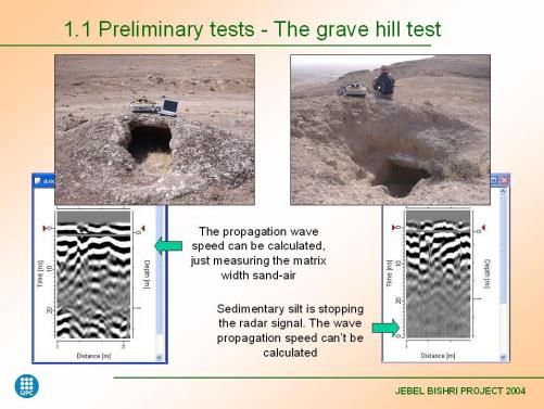
The International Archives of the Photogrammetry, Remote Sensing and Spatial Information Sciences, Volume XLII-2/W11, 2019
                 GEORES 2019 – 2nd International Conference of Geomatics and Restoration, 8–10 May 2019, Milan, Italy

                                                                         cultures compared to the sedentary ones and the importance of
                                                                         such cultures in the time scale of the human past.

                                                                                                  REFERENCES

                                                                         Aldenderfer, M., Maschner, H.D.G. 1996. Anthropology, Space,
                                                                         and Geographic Information Systems. Oxford: Oxford University
                                                                         Press.

                                                                         Bell, G.L. 1908/ new imp. 1985. Syria: the Desert and the Sown.
                                                                         London: Darf Publishers Ltd.

                                                                         Bird, D.W. and Bird, R. B. 2005. Evolutionary and Ecological
                                                                         Understanding of the Economics of Desert Societies Comparing
 Figure 18. 3D-landscape model of pastoral steppe on Jebel Bishri        the Great Basin USA and the Australian Deserts. Desert Peoples,
  constructed by fusing QuickBird imagery with ASTER-DEM                 archaeological perspectives, ed. by Veth, P., Smith, M. and
              data. Constructed by M. Törmä 2012.                        Hiscock, P. Oxford: Blackwells, 81–99.

                7. MIGRATIONS, WAYS OF                                   Bradbury, J. 2009. Beyond a Landscape of Tells: Subsistence,
              COMMUNICATION AND TRADE                                    Society and Interaction within Basalt Environs of Homs, Syria.
                                                                         CBRL, Bulletin of the Council for British Research in the Levant
There are various ways people come in contact with each other.           4, 38–41.
For mobile people migration is an integral part of their life style if
we think about local migration depending on seasonality and              Brooks, R. R. and Johannes, D. 1990. Phytoarchaeology.
interareal migration (Rouse, 1986) caused, for example, by               Historical, Ethno- & Economic Botany Series, Vol. 3. Wilshire:
drought or war. However, migrations are hard to trace by remote          Dioscorides Press.
sensing, and types of spread of cultural features are often followed
by spatial comparison to material remains through survey or/and          Burmeister, S. 2000. Archaeology and Migration: Approaches to
excavation discoveries. However, the tracks such as hollow ways          an Archaeological Proof of Migration. Current Anthropology
have been identified in the landscape of Syria, and they have been       41.4, 539–567.
studied by remote sensing using CORONA satellite photographs.
These ancient tracks were used by people taking their animals to         Butzer, K. 1981. Archaeology as Human Ecology. Cambridge:
pastures and fields, but also communicating and trade between            Cambridge University Press.
settlements (Ur, 2003). On the other hand, we have traced caravan
routes by Landsat imagery (Lönnqvist et al., 2011).                      Cavalli-Sforza, L.L. 1996. The Great Human Diasporas: The
                                                                         History of Diversity and Evolution. Perseus Books.
Trade was already initiated in the Stone Age, but the means of
exchange have changed over time. Obsidian, volcanic glass, that is       Chang, C. 2005. The Grass is Greener on the Other Side, in
also present on Jebel Bishri, was acquired from Anatolia, and            Archaeology and Ethnoarchaeology of Mobility, ed. Seller, F.,
there is evidence that obsidian was a commodity to be exchanged          Greaves, R. and Yu, P.-L, 184–200.
in prehistory. Flint in the region of Jebel Bishri itself is of very
high quality and was used for producing tools and weapons. White         Crassard, R., Barge, O., Bichot, C.-E., Élie, C.-E., Brochier, J. É.,
ware and pottery start emerging in the Neolithic times and               Chahoud, J., Chambrade, M.-L., Chataigner, C., Madi, K.,
continue to the present-day, and such pieces of vessels were found       Régagnon, E., Seba, H., Vila, E. 2014. Addressing the Desert
on Jebel Bishri (Lönnqvist et al., 2011). However, small trade           Kites Phenomenon and Its Global Range Through a Multi-proxy
goods are not generally detectable by remote sensing but                 Approach. Journal of Archaeological Method and Theory 22,
caravanserai as well as caravan cities, including such as Petra,         1093–1121.
Palmyra (Silver et al., 2018) and the mentioned Ubar, can be
traced.                                                                  Cribb, R. 1992. Nomads in Archaeology. New Studies in
                                                                         archaeology. Cambridge: Cambridge University Press.
                 8. CONCLUDING REMARKS
                                                                         Dietrich, O., Heun, M., Notroff, J., Schmidt, K. And Zarnkow, M.
This paper has provided an avenue for studying ancient and more          2012. The role of cult and Feasting in the emergence of Neolithic
recent mobile people, whether hunter-gatherers or pastoral               cimmunities. New evidence from Göbekli Tepe, south-eastern
nomads, and their environments by remote sensing. We have                Turkey. Antiquity 86, 674–695.
shown which data sources are applicable to particular types of           Heathcote, R.L. 1983. Arid Lands: Their Use and Abuse. Themes
remains in the Near East. Also the environmental questions               in Resource Management. London, New York: Longman.
attached to the livelihood of the people living on desert fringes
and steppes have been discussed, and the ways to extract                 Lewis, N.N. 1987. Nomads and settlers in Syria and Jordan,
information of the constraints and possibilities. We also wish to        1800-1980. Cambridge: Cambridge University Press.
highlight the imbalance of World Heritage Sites in view of mobile

                                                   This contribution has been peer-reviewed.
                     https://doi.org/10.5194/isprs-archives-XLII-2-W11-1065-2019 | © Authors 2019. CC BY 4.0 License.                 1071
The International Archives of the Photogrammetry, Remote Sensing and Spatial Information Sciences, Volume XLII-2/W11, 2019
                 GEORES 2019 – 2nd International Conference of Geomatics and Restoration, 8–10 May 2019, Milan, Italy

Khazanov, A. 1994. 2nd ed. Nomads and the Outside World.              Finnish project SYGIS, British Archaeological            Reports,
Madison: University of Wisconsin Press.                               International Series 2230, Oxford: Archaeopress.

Lem, P. 2017. Finding a Lost City; Fingerprints of Ubar.              Lönnqvist, M., Törmä, M., Lönnqvist K., Nuñez, M. 2012.
https:// earthobservatory.nasa.gov. Accessed March 15th, 2019.        Satellite Perspective on Highland–Lowland Human Interaction in
                                                                      Ancient Syria. International Archives of Photogrammetry, Remote
Long-term Landscape Environment and Climate Change Studies:           Sensing and Spatial Information Sciences, Vol. XXXIX B4, XXII
from the Past through to Predictive Models for Future                 ISPRS Congress 25 August -01 September 2012, ed. Madden, M.
Developments 2012. CBRL 2012, Bulletin of the Council for             and Shortis, M., Melbourne, Australia, 455–460.
British Research in the Levant, 7, 60–64.
                                                                      Oppenheimer, S. 2004. Out of Eden: The Peopling of the World.
Lönnqvist, M. 2014. The Emergence of Pastoral Transhumance at         London: Constable & Robinson Ltd.
Jebel Bishri in Central Syria. Settlement Dynamics and Human-
Landscape Interaction in the Dry Steppes of Syria, ed. Morandi        Richards, J. 1993. Remote Sensing Digital Image Analysis. 2nd ed.
Bonacossi, D., Studia Chaburensia I, Vol. 4, 93–109.                  Berlin: Springer.

Lönnqvist, M. and Stefanakis, E. 2009. GIScience in                   Rouse, I. 1986. Migrations in Prehistory: Inferring Population
Archaeology: Ancient Human Traces in Automated Space. The             Movement from Cultural Remains. New Haven, London: Yale
Manual of Geographic Information Systems, ed. Madden, M.,             University Press.
Bethesda, Maryland: American Society of Photogrammetry and
Remote Sensing, 1221–1259.                                            Schmidt, K. 2012. A Stone Age Sanctuary in South-eastern
                                                                      Anatolia. Berlin: Ex Oriente/Dbusiness.
Lönnqvist, M. and Törmä, M. 2003. SYGIS–The Finnish
Archaeological Project in Syria, The ICOMOS & ISPRS                   Silver, M. 2016a. Conservation Techniques in Cultural Heritage.
Committee for Documentation of Cultural Heritage. New                 3D Recording, Documentation and Management of Cultural
Perspectives to Save Cultural Heritage, CIPA 2003, XIXth              Heritage, ed. Stylianidis, E., Remondino, F., Dunbeath, Caithness,
International Symposium, Antalya, Turkey, The ISPRS                   Scotland, UK: Whittles Publishing, 15–105.
International Archives of the Photogrammetry, Remote Sensing
and SpatialInformation Sciences Vol. XXXIV-5/C15, 609–614             Silver, M. 2016b. Visualising Invisible Nomads. Unpublished
                                                                      paper. World Heritage Strategy Forum. Harvard University, 9th to
Lönnqvist, M., Törmä, M., Okkonen, J., Lönnqvist, K., Nuñez,          22th September, 2016.
M., Latikka, J. 2007. The Euphrates Channel Changes and
Archaeology along Jebel Bishri in Syria. Proceedings of the XXI       Silver, M., Fangi, G., Denker, A. 2018. Reviving Palmyra in
Symposium, CIPA 2007, Athens, Anticipating the Future of the          Multiple Dimensions. Images, Ruins and Cultural Memory.
Cultural past, Vol. 1., ed. Georgopoulos, A., The International       Caithness, UK: Whittles Publishing.
Archives of Photogrammetry, Remote Sensing and Spatial
Information Sciences, Vol. XXXVI-5/C53, 465–470.                      Silver, K., Silver, M., Törmä, M., Okkonen, J., Okkonen, T. 2017.
                                                                      Applying Satellite Data Sources in the Documentation and
Lönnqvist, M., Törmä, M., Lönnqvist, K., Nuñez, M. 2009.              Landscape Modelling for Graeco-Roman/Byzantine Fortified Sites
Site Catchment Analysis Applied to the Pastoral Landscape of          in the Tūr Abdin Area, Eastern Turkey. ISPRS Annals of the
Jebel Bishri in Syria Using QuickBird Satellite Imagery and           Photogrammetry, Remote Sensing and Spatial Information
Aster-Dem Data. Proceedings of CIPA 2009, Kyoto,                      Sciences, Vol. IV-2/W2, 2017, 26th International CIPA
http://cipa.icomos.org/fileadmin/papers/kyoto2009/181pdf              Symposium 2017, 28 August–01 September 2017, Ottawa,
                                                                      Canada, 251–258.
Lönnqvist, M., Törmä, M., Lönnqvist, K., Nuñez, M., Okkonen,
J., Stout Whiting, M., Riihiaho, H., Nissinen, M. 2010.               Ur, J. 2003. CORONA Satellite Photography and Ancient Road
Desertification and Ethnoarchaeology: Studying Hazards in the         Networks: A Northern Mesopotamian Case Study. Antiquity 77,
Nomadic Environment of Jebel Bishri in Syria. Proceedings of the      102–115.
6th International Congress on the Archaeology of the Ancient
Near East, May 5th-10th 2008, “Sapienza”- Università di Roma,         Wendrich, W. and Barnard, H. 2008. The Archaeology of
Vol. 1, Near Eastern Archaeology in the Past, Present and Future:     Mobility: Definitions and Research Approaches. The Archaeology
Heritage and Identity, Ethnoarchaeological and Interdisciplinary      of Mobility, Old World and New World Nomadism, Barnard, H.
Approach: Results and Perspectives, Visual Expression and Craft       and Wendrich, W., Cotsen Advanced seminars 4, Los Angeles:
Production in the Definition of Social Relations and Status, ed. by   Cotsen Institute of Archaeology, University of California, 1–21.
Matthiae, P., Pinnock, F., Nigro, L., Marchetti, N. with the
collaboration of L. Romano, Wiesbaden: Harrassowitz Verlag,           Zarins, J. 1992. Archaeological and Chronological Problems
369–390.                                                              within the Greater Southwest Asian Arid Zone, 8500–1850 B.C.
                                                                      Chronologies in Old World Archaeology. Third Edition, Edited by
Lönnqvist, M., Törmä, M., Lönnqvist, K., Nuñez, M. 2011. Jebel        R.W. Ehrich, Vol. I. Chicago and London: The University of
Bishri in Focus: Remote sensing, archaeological surveying,            Chicago Press, 42–62.
mapping and GIS studies of Jebel Bishri in central Syria by the

                                                  This contribution has been peer-reviewed.
                    https://doi.org/10.5194/isprs-archives-XLII-2-W11-1065-2019 | © Authors 2019. CC BY 4.0 License.            1072
You can also read