Action Plans for an integrated network of ports and hubs in Adrion Region - Integrated and Sustainable Transport in Efficient Network - ISTEN ...
←
→
Page content transcription
If your browser does not render page correctly, please read the page content below
Integrated and Sustainable Transport
                                        in Efficient Network - ISTEN

                                                 PORTFOLIO

                              Action Plans for an integrated network
                                of ports and hubs in Adrion Region
Photo by Stefano Zerauschek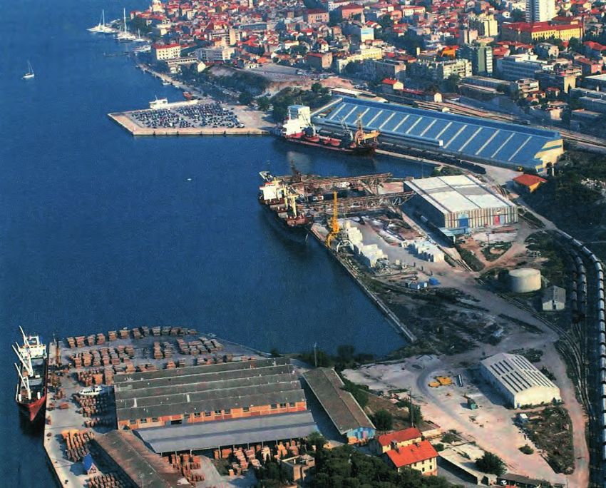
Integrated and Sustainable Transport
                in Efficient Network

                   PORTFOLIO

Action Plans for an integrated network
  of ports and hubs in Adrion Region

                     October 2020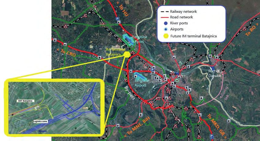
Document information

    Abstract
    The ISTEN Interreg ADRION project aims at qualifying the Adriatic and Ionian Ports
    as strategic nodes and hubs for the ADRION Region by setting up strategies, a
    transnational cooperation network and a joint action plan to improve hinterland
    intermodal connections, pushing in particular rail freight flows and last-mile
    connection to the TEN-T Corridors.
    Starting from the analysis of the main bottlenecks towards achieving an integrated
    network of ports and hubs, each ISTEN project partner identified a set of relevant
    measures to be planned and implemented for the achievement of the desired level
    of integration among port hinterland actors, infrastructures, and operations.
    This document reports an overview of the main characteristics of the Local Action Plans
    defined by the ISTEN project partners. It opens with a summary of the main findings of
    the local context analysis and Cooperation network activities. Then, the most relevant
    information on each Action Plan is outlined, following the same structure.

    Keywords
    Local Action Plan, Port-hinterland integration,
    Freight intermodal transport, Port logistics

    Authors
       Editor(s)              Andrea Lorenzini, Eleonora Ercoli - MemEx
                              Giuseppe Luppino - ITL
       Contributors           Anna Giarandoni - ITL
                              Giorgio Ambrosino - MemEx
                              Domenico Gattuso - UNIMED

               This leaflet has been produced with the financial assistance of the European Union. The content of
               the leaflet is the sole responsibility of theISTEN project and can under no circumstances be regarded
               as reflecting the position of the European Union and/or ADRION programme authorities.

2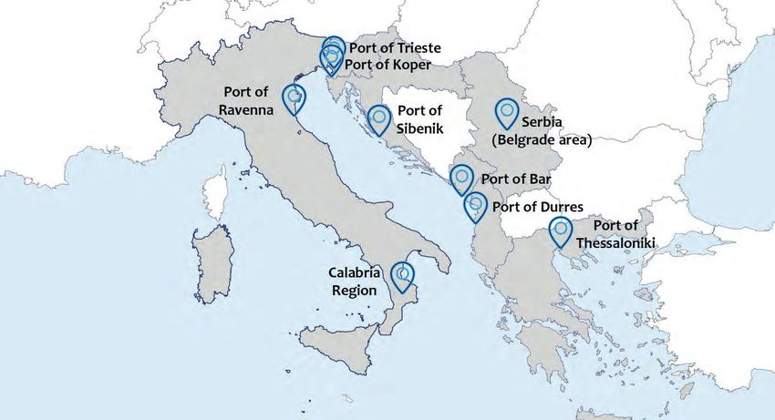
Table of Contents
1. Introduction . . . . . . . . . . . . . . . . . . . . . . . . . . . . . . . . . . . . . . . . . . . . . . . . . . . . . . . . . . . . . . . . . . . . . . . . . . . . . . . . 5
2. The ISTEN approach . . . . . . . . . . . . . . . . . . . . . . . . . . . . . . . . . . . . . . . . . . . . . . . . . . . . . . . . . . . . . . . . . . . . . . . . . 6
3. Overview of the ISTEN LAP . . . . . . . . . . . . . . . . . . . . . . . . . . . . . . . . . . . . . . . . . . . . . . . . . . . . . . . . . . . . . . . . . . . 8
4. Port of Ravenna . . . . . . . . . . . . . . . . . . . . . . . . . . . . . . . . . . . . . . . . . . . . . . . . . . . . . . . . . . . . . . . . . . . . . . . . . . . . 9
   Improved relation between the port and the Ceramic District located in the regional hinterland . . . . . . . . . . . 10
      Strengthening the last-mile connections and developing maritime infrastructural
      improvements for canal depth, new terminals and quays  . . . . . . . . . . . . . . . . . . . . . . . . . . . . . . . . . . . . . . . . . . . 12
5. Calabria Region . . . . . . . . . . . . . . . . . . . . . . . . . . . . . . . . . . . . . . . . . . . . . . . . . . . . . . . . . . . . . . . . . . . . . . . . . . . . 15
   Calabria Region as competitive European terminal port for the Silk Maritime Road  . . . . . . . . . . . . . . . . . . . . . . 16
   Hub and Spoke System in Euro-Mediterranean Area for Ro-Ro traffic with hub in Calabria Region . . . . . . . . . . . 17
   Integration and connection to the ADRION networks. Regional Level . . . . . . . . . . . . . . . . . . . . . . . . . . . . . . . . . . . 20
   Integration and connection to the ADRION networks Local Level – Last mile links  . . . . . . . . . . . . . . . . . . . . . . . . 23
6. Port of Koper . . . . . . . . . . . . . . . . . . . . . . . . . . . . . . . . . . . . . . . . . . . . . . . . . . . . . . . . . . . . . . . . . . . . . . . . . . . . . . 27
   Update of container and car terminals and enhanced railway connection between Koper and Divača  . . . . . . . 28
   Introduction of ICT tools to digitalize some aspects of the logistic chain and streamline
   the procedures at the terminals and gates  . . . . . . . . . . . . . . . . . . . . . . . . . . . . . . . . . . . . . . . . . . . . . . . . . . . . . . . 31
7. Port of Trieste . . . . . . . . . . . . . . . . . . . . . . . . . . . . . . . . . . . . . . . . . . . . . . . . . . . . . . . . . . . . . . . . . . . . . . . . . . . . . 35
      Upgrade of the Campo Marzio – port shunting area and improved connection between
      Aquilinia station and the Industrial Zone of Trieste . . . . . . . . . . . . . . . . . . . . . . . . . . . . . . . . . . . . . . . . . . . . . . . . . 36
      Development of EDI with the RUs serving the Port of Trieste  . . . . . . . . . . . . . . . . . . . . . . . . . . . . . . . . . . . . . . . . . 39
      Upgrade of the Sinfomar PCS for streamlining inland freight flows  . . . . . . . . . . . . . . . . . . . . . . . . . . . . . . . . . . . . 41
8. Port of Thessaloniki . . . . . . . . . . . . . . . . . . . . . . . . . . . . . . . . . . . . . . . . . . . . . . . . . . . . . . . . . . . . . . . . . . . . . . . . 44
   Setting up of an Innovation Hub for increasing the port competitiveness and efficiency  . . . . . . . . . . . . . . . . . . 45
      Combined transport solution for the enhancement of port’s rail and road connection
      at domestic and regional level  . . . . . . . . . . . . . . . . . . . . . . . . . . . . . . . . . . . . . . . . . . . . . . . . . . . . . . . . . . . . . . . . . 49
9. Port of Durres  . . . . . . . . . . . . . . . . . . . . . . . . . . . . . . . . . . . . . . . . . . . . . . . . . . . . . . . . . . . . . . . . . . . . . . . . . . . . . 52
   Infrastuctural intervention/improvements on canal depth and port/rail industry . . . . . . . . . . . . . . . . . . . . . . . . 53
   Enhanced maritime regulatory system in line with IMO and EU standards and regulations . . . . . . . . . . . . . . . . . 55
10. Port of Bar  . . . . . . . . . . . . . . . . . . . . . . . . . . . . . . . . . . . . . . . . . . . . . . . . . . . . . . . . . . . . . . . . . . . . . . . . . . . . . . . . 57
    Comprehensive plan for improving the port system conditions and rail and road network  . . . . . . . . . . . . . . . . 58
    Enhanced information flow through Bar PCS system  . . . . . . . . . . . . . . . . . . . . . . . . . . . . . . . . . . . . . . . . . . . . . . . . 61
11. Serbia - Belgrade Area  . . . . . . . . . . . . . . . . . . . . . . . . . . . . . . . . . . . . . . . . . . . . . . . . . . . . . . . . . . . . . . . . . . . . . 64
    Improved connectivity of regional multimodal corridors and enabled intermodality . . . . . . . . . . . . . . . . . . . . . . 65
    Creation and enhancement of dedicated environment for implementation of innovative solutions  . . . . . . . . . 69
12. Šibenik - Knin Region  . . . . . . . . . . . . . . . . . . . . . . . . . . . . . . . . . . . . . . . . . . . . . . . . . . . . . . . . . . . . . . . . . . . . . . 72
    Modernisation of Šibenik Port equipment and improvement of the Una and Lika railway . . . . . . . . . . . . . . . . . . 73
    Improving the cooperation between regional, national and transnational stakeholders . . . . . . . . . . . . . . . . . . . 77

                                             List of abbreviations and definitions
                                      AP: Action Plans • LAP: Local Action Plan •
                         PCS: Port Community System • TEN-T: Trans-European Transport Network

                                                                                                                                                                                      3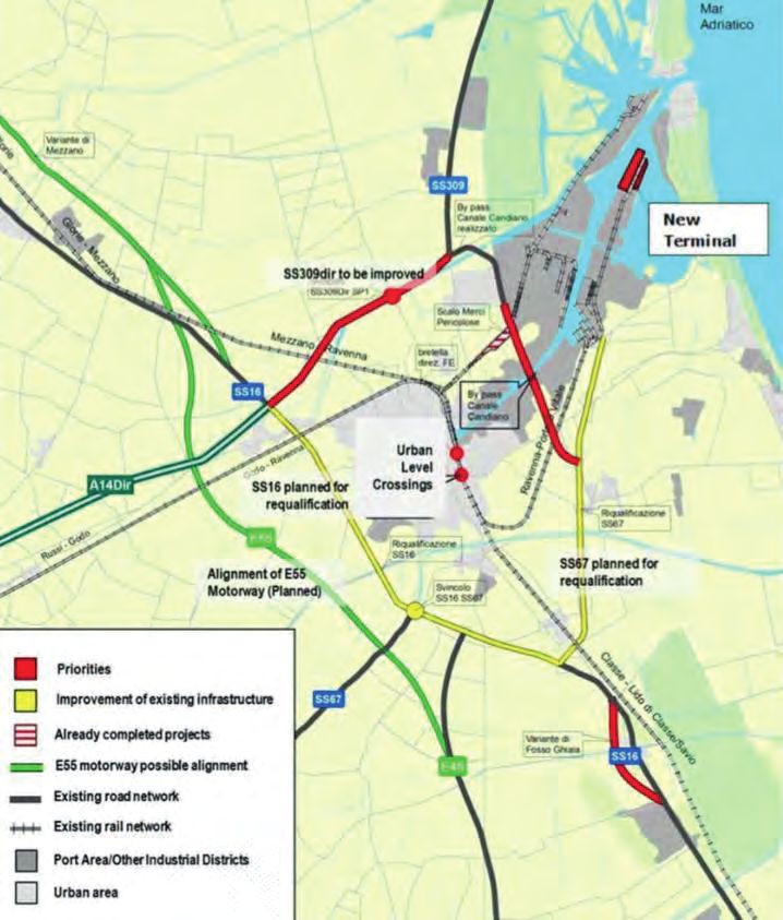
List of Figures
    Figure   01   -   Ports and regions addressed by the ISTEN project . . . . . . . . . . . . . . . . . . . . . . . . . . . . . . . .  5
    Figure   02   -   ISTEN methodological approach . . . . . . . . . . . . . . . . . . . . . . . . . . . . . . . . . . . . . . . . . . . . . . .  6
    Figure   03   -   Overview of the ISTEN Local Action Plans . . . . . . . . . . . . . . . . . . . . . . . . . . . . . . . . . . . . . . .  8
    Figure   04   -   Port of Ravenna . . . . . . . . . . . . . . . . . . . . . . . . . . . . . . . . . . . . . . . . . . . . . . . . . . . . . . . . . . . . .  9
    Figure   05   -   Port last mile connections . . . . . . . . . . . . . . . . . . . . . . . . . . . . . . . . . . . . . . . . . . . . . . . . . . .  12
    Figure   06   -   Road sections interested by the planning upgrades . . . . . . . . . . . . . . . . . . . . . . . . . . . . .  13
    Figure   07   -   Stage I of the Ravenna Port Hub project  . . . . . . . . . . . . . . . . . . . . . . . . . . . . . . . . . . . . . .  13
    Figure   08   -   Port of Gioia Tauro  . . . . . . . . . . . . . . . . . . . . . . . . . . . . . . . . . . . . . . . . . . . . . . . . . . . . . . . . .  15
    Figure   09   -   Comparison between the Long Bridgeand Short Bridge . . . . . . . . . . . . . . . . . . . . . . . . . .  18
    Figure   10   -   Actions on the regional railway network  . . . . . . . . . . . . . . . . . . . . . . . . . . . . . . . . . . . . . .  20
    Figure   11   -   Inclusion of the Ionian railway in the TEN-T COMPREHENSIVE NETWORK . . . . . . . . . . . . . .  20
    Figure   12   -   Adjustment of axial mass  . . . . . . . . . . . . . . . . . . . . . . . . . . . . . . . . . . . . . . . . . . . . . . . . . . .  21
    Figure   13   -   Adjustment of structure gauge . . . . . . . . . . . . . . . . . . . . . . . . . . . . . . . . . . . . . . . . . . . . . . .  21
    Figure   14   -   Adjustment of railway module . . . . . . . . . . . . . . . . . . . . . . . . . . . . . . . . . . . . . . . . . . . . . . .  21
    Figure   15   -   New proposal for the RFC3 corridor . . . . . . . . . . . . . . . . . . . . . . . . . . . . . . . . . . . . . . . . . . .  22
    Figure   16   -   East by-pass road for Gioia Tauro port  . . . . . . . . . . . . . . . . . . . . . . . . . . . . . . . . . . . . . . . .  23
    Figure   17   -   Railway line San Ferdinando-Rosarno  . . . . . . . . . . . . . . . . . . . . . . . . . . . . . . . . . . . . . . . . .  24
    Figure   18   -   Reorganization of local road viability . . . . . . . . . . . . . . . . . . . . . . . . . . . . . . . . . . . . . . . . .  25
    Figure   19   -   Road connection between Corigliano port and Industrial Area . . . . . . . . . . . . . . . . . . . .  25
    Figure   20   -   New railway link to connect Corigliano port  . . . . . . . . . . . . . . . . . . . . . . . . . . . . . . . . . . .  25
    Figure   21   -   Railway connections to Vibo Valentia industrial area . . . . . . . . . . . . . . . . . . . . . . . . . . . .  26
    Figure   22   -   Port of Koper . . . . . . . . . . . . . . . . . . . . . . . . . . . . . . . . . . . . . . . . . . . . . . . . . . . . . . . . . . . . . .  27
    Figure   23   -   Infrastructural improvements in the Port of Koper . . . . . . . . . . . . . . . . . . . . . . . . . . . . . .  29
    Figure   24   -   Characteristics of the second railway track from Koper to Divača  . . . . . . . . . . . . . . . .  30
    Figure   25   -   First car registered with the new system . . . . . . . . . . . . . . . . . . . . . . . . . . . . . . . . . . . . . .  32
    Figure   26   -   VBS system screenshot . . . . . . . . . . . . . . . . . . . . . . . . . . . . . . . . . . . . . . . . . . . . . . . . . . . . . .  32
    Figure   27   -   Port of Trieste  . . . . . . . . . . . . . . . . . . . . . . . . . . . . . . . . . . . . . . . . . . . . . . . . . . . . . . . . . . . . .  35
    Figure   28   -   Campo Marzio station: current layout . . . . . . . . . . . . . . . . . . . . . . . . . . . . . . . . . . . . . . . . .  36
    Figure   29   -   Sinfomar multi-stakeholder cooperation approach . . . . . . . . . . . . . . . . . . . . . . . . . . . . . .  39
    Figure   30   -   New module in Sinfomar PCS . . . . . . . . . . . . . . . . . . . . . . . . . . . . . . . . . . . . . . . . . . . . . . . . .  42
    Figure   31   -   Pre-arrival notification . . . . . . . . . . . . . . . . . . . . . . . . . . . . . . . . . . . . . . . . . . . . . . . . . . . . . .  42
    Figure   32   -   Port of Thessaloniki  . . . . . . . . . . . . . . . . . . . . . . . . . . . . . . . . . . . . . . . . . . . . . . . . . . . . . . . .  44
    Figure   33   -   The Innovation Hub Administrative team . . . . . . . . . . . . . . . . . . . . . . . . . . . . . . . . . . . . . .  45
    Figure   34   -   Port of Durres  . . . . . . . . . . . . . . . . . . . . . . . . . . . . . . . . . . . . . . . . . . . . . . . . . . . . . . . . . . . . .  52
    Figure   35   -   An overview of the cargo port of Durres . . . . . . . . . . . . . . . . . . . . . . . . . . . . . . . . . . . . . . .  54
    Figure   36   -   Port of Bar  . . . . . . . . . . . . . . . . . . . . . . . . . . . . . . . . . . . . . . . . . . . . . . . . . . . . . . . . . . . . . . . .  57
    Figure   37   -   Position of the Volujica quay in the Port of Bar  . . . . . . . . . . . . . . . . . . . . . . . . . . . . . . . .  58
    Figure   38   -   Extension of the quay at Passenger terminal in Port of Bar  . . . . . . . . . . . . . . . . . . . . . .  59
    Figure   39   -   Road infrastructures serving the port  . . . . . . . . . . . . . . . . . . . . . . . . . . . . . . . . . . . . . . . .  59
    Figure   40   -   Position of the substations  . . . . . . . . . . . . . . . . . . . . . . . . . . . . . . . . . . . . . . . . . . . . . . . . . .  59
    Figure   41   -   Position of the new closed warehouse  . . . . . . . . . . . . . . . . . . . . . . . . . . . . . . . . . . . . . . . .  59
    Figure   42   -   Main steps in the arrival/departure of cargo . . . . . . . . . . . . . . . . . . . . . . . . . . . . . . . . . . .  62
    Figure   43   -   An overview of the Belgrade area  . . . . . . . . . . . . . . . . . . . . . . . . . . . . . . . . . . . . . . . . . . . .  64
    Figure   44   -   Overview of the locations of the planned actions  . . . . . . . . . . . . . . . . . . . . . . . . . . . . . .  65
    Figure   45   -   Missing link and locations of terminal in the Belgrade area railway network  . . . . . . .  66
    Figure   46   -   Rail/Road corridors and railway network of Serbia  . . . . . . . . . . . . . . . . . . . . . . . . . . . . .  67
    Figure   47   -   Position of the new Intermodal terminal “Batajnica”  . . . . . . . . . . . . . . . . . . . . . . . . . . .  67
    Figure   48   -   Port of Šibenik . . . . . . . . . . . . . . . . . . . . . . . . . . . . . . . . . . . . . . . . . . . . . . . . . . . . . . . . . . . . .  72
    Figure   49   -   Šibenik Port organisation  . . . . . . . . . . . . . . . . . . . . . . . . . . . . . . . . . . . . . . . . . . . . . . . . . . .  74
    Figure   50   -   Terminal for bulk cargo  . . . . . . . . . . . . . . . . . . . . . . . . . . . . . . . . . . . . . . . . . . . . . . . . . . . . .  74
    Figure   51   -   Railway network in the Republic of Croatia and Bosnia and Herzegovina  . . . . . . . . . .  75

4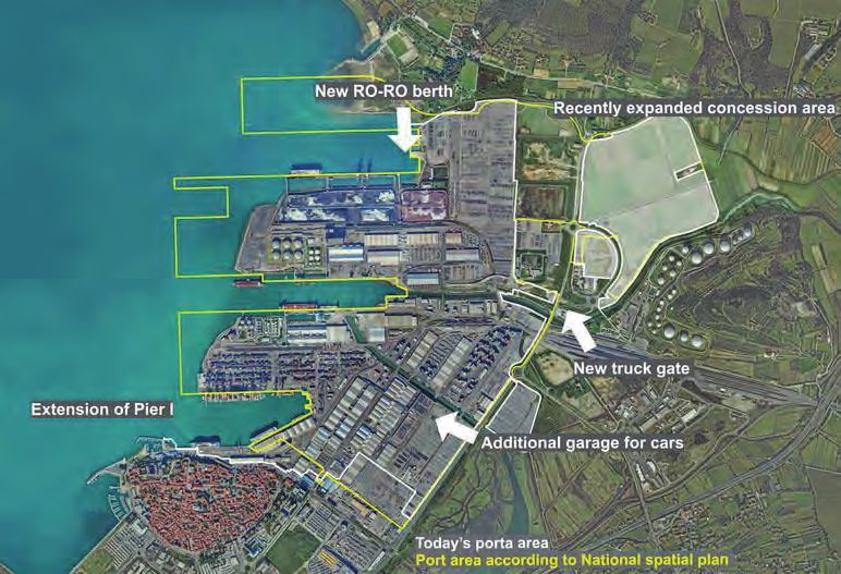
1. Introduction

The ISTEN Interreg EU project aims at qualifying the Adriatic and Ionian Ports as strategic nodes and hubs
for the ADRION Region by setting up strategies, a transnational cooperation network and a joint action
plan to improve hinterland intermodal connections, pushing in particular rail freight flows and last mile
connection to the TEN-T Corridors.
ISTEN Project Consortium is led by Mediterranean University of Reggio Calabria and involves ports from Italy,
Croatia, Slovenia, Greece, and Montenegro as main Mediterranean gateways to the TEN-T and Motorway of
the Sea, plus other research institutions and stakeholders from Albania, Italy, Serbia and Greece.

The project objectives                                    The project activities
The core objectives of the project consist of:            ISTEN activities are organised through two different
u steering priorities of involved territories by          pillars:
  identifying major bottlenecks and developing                WP T1 – Transnational Cooperation Network. It
  integrated infrastructure planning at                       aims to carry out an in-depth analysis of the local
  transnational level and consistent investment               characteristics, context and bottlenecks of ISTEN
  strategies;                                                 sites and develop a Transnational Cooperation
v providing guidelines and criteria for defining              Network, with related meetings and reports.
  legal, technical and operational conditions                WP T2 – Action Plans for ADRION Hubs. It aims to
  useful to establish an efficient ADRION
                                                             u   set up and develop Local Stakeholders
  transnational network;
                                                                 Working Groups,
w building capacity in planning infrastructures              v   drafting of site-specific Local Action Plan,
  and identifying measures and actions to be
                                                                 one per each of the ISTEN site, and
  adopted for setting-up integrated hubs and
                                                             w   building of a Strategic Action Plan for
x enhancing the efficiency and environmental                     ADRION Region.
  sustainability of freight logistics flows across
  the ADRION area.

                           Figure 1 - Ports and regions addressed by the ISTEN project

                                                                                                                    5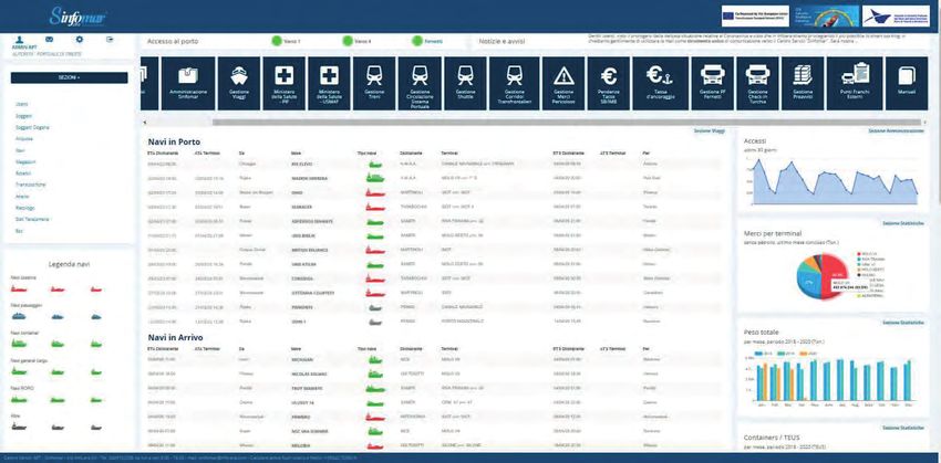
2. The ISTEN approach

    Bottlenecks analysis                                Cooperation network                                     Planning
    Improved knowledge on                               Strengthened cooperation among                          Enhanced capacity in planning
    the current port-hinterland                         port and hinterland stakeholders                        and organising efficient and
    bottlenekcs in the ADRION Region                    at local/hub and transnational/                         environmentally sustainable
                                                        network level                                           logistic services
    In 2018 and 2019, the ISTEN Project                A set of different local Working                        Based on the findings and outcomes
    had developed a comprehensive                      groups (WGs) was developed since                        of the local Working Groups, each
    analysis at both local and transna-                the project kicked-off. Each WG                         ISTEN project partner identified
    tional/EU level of the existing and                grouped key institutional and                           a set of relevant measures to be
    potential commercial flows across                  private stakeholders involved                           planned and implemented for
    the ADRION area, identifying the                   in the logistics and intermodal                         the achievement of the desired
    main bottlenekcs towards achiev-                   chain, such as port authorities,                        level of integration among port-
    ing an ‘integrated network of ports                municipalities, freight/terminal                        hinterland actors, infrastructures
    and hubs’. The analysis was based                  operators, shipping agents, etc.).                      and operations.
    on five different cluster: marker,                 The WGs periodically held meetings,                     As final activity, the Project has the
    infrastructure, operation, institu-                coordinated by the ISTEN project                        ambition of gaining findings from the
    tion, and innovation. Each partner                 partners, to discuss about the                          overall of ISTEN Project activities for
    identified some critical bottlenecks               needs, problems, requirements                           drafting a transnational strategy/
    in each of these categories.                       and most important actions to                           plan for the development of an
    In parallel, the Consortium made                   be developed locally in order to                        integrated hubs network at ADRION
    a comprehensive overview of best                   overcome the main identified                            level. While ISTEN Local Action Plans
    practices on port-hinterland inte-                 port-hinterland bottlenecks. In                         have been developed for answering
    gration, identifying more than 30                  parallel, a transnational cooperation                   specific needs of the target port and
    different initiatives.                             network was set up to facilitate                        its hinterland, this strategy will be
                                                       the exchange of information and                         a key element for defining future
                                                       knowledge among key transport and                       investments and opportunities for
                                                       logistics actors.                                       improve the competitiveness of the
                                                                                                               ADRION region and the operativity
                                                                                                               and integrations of the different
                                                                                                               nodes of the logistic chain.

             Layer 1                          WP T1                                                                   WP T2
                                    Transnational Cooperation                                                Action Plans for ADRION
                                            Network                                                                    Hubs

                                          Sub activity T1.2     Sub activity T1.3        Sub activity T2.1          Sub activity            Sub activity
                    Sub activity                                                         Set up of Local                T2.2                    T2.3
                        T1.1              Macro analysis         Transnational            Stakeholders             Local Action              Strategic
                                          at ADRION and          Cooperation                Working                  Plans for             Action Plan for
                   Local analysis             EU Level          Network (TCN)             Groups (WGs)            setting the hub          ADRION Region

                         Commission Staff
          Layer 2        Working Document                                    DT 2.3.1
                           of 29.01.2019
                                                                      Strategic Action Plan
                       EU Strategy for the                             for ADRION Region                                            Clustersustainable
                                                                                                                                            No. 2: Integrated
                       Adriatic and Ionian                                                                                          Multimodal
                        Region (EUSAIR)                                                                                             water and land transport

                    Layer 3                                   CONSULTATION &
                                                                                                                 DISSEMINATION
                                                                VALIDATION

                                                     ISTEN Local                                                                Adrion
                   Selected external                Stakeholders                    ISTEN Project                            Capitalisation
                        experts                    Working Groups                    Consortium                                 events

                                                     Figure 2 - ISTEN methodological approach

6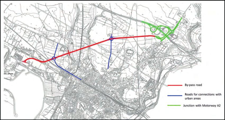
Key findings from the bottlenecks analysis

                                                                              BOTTLENECKS

          Market                          Infrastructural                             Operational                              Institutional                                   Innovation
 • Limited hinterland                    • Inadequate port                        • Not aligned operational                • Fragmented planning                      • Low innovation
   market of the port                      infrastructure                           processes of port-                       at local/regional/                         content in the services
 • Limited demand for                    • Lack of port expansion                   hinterland actors                        national level                             provided
   intermodal port-                        area                                   • Not aligned operational                • Problematic national                     • Not harmonised
   hinterland services                   • Inadequate capacity                      processes between                        legal/institutional                        (or missing) digital
                                           of port handling                         operational & public                     framework                                  information exchange
                                           equipment                                actors                                 • Low coordination/                          between port-
                                         • Inadequate port                        • Limited breadth (or                      cooperation between                        hinterland actors and
                                           infrastructure                           inadequate quality) of                   the port and the                           between operational &
                                                                                    services provided by                     city in terms of                           public actors
                                         • Inadequate (capacity
                                           of) equipment of the                     the port and/or the                      port-hinterland                          • Inability to provide
                                           rail operator                            hinterland actors                        development                                seamless port-
                                                                                  • Inadequate cross-                      • Low coordination/                          hinterland cargo
                                         • Inadequate capacity                                                                                                          visibility to operational
                                           of hinterland transport                  border coordination                      cooperation with
                                                                                    of port-hinterland                       other ports or port-                       actors and shippers
                                           networks
                                                                                    corridor                                 hinterland corridors
                                         • Infrastructure/
                                           equipment
                                           incompatibilities
                                           between port and
                                           hinterland transport
                                           operators
                                         • Inadequate soft
                                           infrastructure

The Methodology for drafting the LAP
The results of each WG discussion have been analysed and elaborated for identifying the local measures most
relevant at site level to foster the integration of port with its hinterland. The steps and specific actions for the
implementation of these measures have been developed in the Local Actions Plans (LAP). The LAP are planning
instruments detailing the main interventions and measures needed to address and overcome some of the identified
bottlenecks and foster the integration of the port with its hinterland.
ITL Foundation was the leader of this activity coordinated the ISTEN partners in the elaboration of the specific local
action plans (one per each ISTEN site). A common methodology was defined based on the Canvas approach, which
has been useful in supporting and summarising the discussions held at local level with the relevant stakeholders.
More detailed information have been reported on D.T.2.2.1 - ISTEN Common Methodology for Local Action Plans,
available at https://isten.adrioninterreg.eu/news/isten-technical-deliverables-wpt2-1

            1                           2                          3                             4                            5                            6                               7
   STAKEHOLDERS                       KEY                                                  PROBLEMS                    TIMESCALE                        RISK                          FUNDING
     INVOLVED                       ACTIONS                       AIMS                       FACED                  IMPLEMENTATION                    ANALYSIS                        SOURCES
 • With are the main         • Main steps to solve the   • The value proposition      • List here the main          • Steps and actions         • Understanding why             Source affording:
   stakeholders identified     problem and to reach        of your action. In this      problems you                  linked to a timeframe.      actions fail to deliver?      • EU grants/subsidies
   and engaged you             your objectives.            section you may list the     encountered during the        Important to estimate     • Doesn’t achieve required      • National and regional
   consider important to                                   main objectives and why      definition of this action     when the action will be     outcome                         government subsidies
   reach your objective.                                   you are considering this     plan                          implemented               • Resource & delivery issues
                                                           action so important                                                                  • Changing partner/             • Revenue funding from
                                                                                                                                                  stakeholder perspectives        public sector activities
                                                                                                                                                • Technology shift              • Private sector operators,
                                                                                                                                                • Identifying suitable            developers, industry
                                                                                                                                                  mitigation measures to        • Other sources such
                                                                                                                                                  address this                    bankleans & private
                                                                                                                                                • Risk management                 investment
                                                                                                                                                  processes built into
                                                                                                                                                  action plan

                                                                                                                                                                                                              7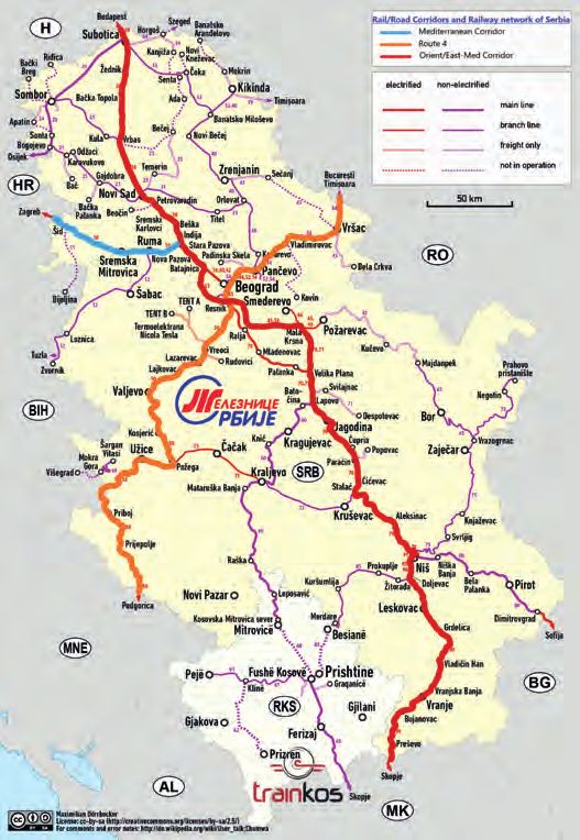
3. Overview of the ISTEN LAP

                                                                       OPE
                                                                           RA
                                     ET                                      TI

                                                         RAVENNA
                                                         PORT OF
                           RK

                                                                                       ON
                                                                       PE F
                                        CA REG

                                                                    KO RT O
                        MA

                                                                                           AL
                                                                         R
                                          LA IO
                                             BR N

                                                                     PO
                                               IA
                                                                                   OF
                                                                              PORT ES

                                                                   R AL
                                PORT OF             IN
                              THESSALON                                        DURR
                                                 F R AS
                                        IKI

                                                                   TU
                                                                             PO
                                            F           T RUC               SIB RT OF
                                        RTO                                    ENI
                      INN

                                      PO BAR                                       K
                                                                BEL

                                                                                           L
                                                                 SER RADE
                                                  TRIET OF
                                                      STE

                                                                                           NA
                         OV

                                                                    G
                                                                    BIA
                                                  POR

                                TI
                           A

                                     ON                                              IOT
                                                                                   T U
                                                                               I
                                                                    IN ST
                                     Figure 3 - Overview of the ISTEN Local Action Plans

    Each ISTEN project partner developed a specific             StartUp Incubator, a Digital Skill Academy, and other
    Local Action Plan addressing those areas that               structures. Also, Serbia moved in this direction
    were commonly recognized as key priorities in the           and planned similar measures. The Action Plans
    discussion with the stakeholders involved in the            of Ravenna and Calabria Region were focused on
    elaboration of the strategy.                                expanding the hinterland market of the port, the
    The enhancement of reliable and efficient information       first by strengthening the connection between the
    flows of data among different stakeholders involved         port and the Ceramic industry District, the second
    in the port-hinterland operations was identified as a       by planning commercial strategies for better
    key priority in the port of Trieste and Koper, which        positioning the Calabrian ports in the Deep sea and
    respectively focused their plan on the upgrade              Short sea main shipping routes. The Sibenik Knin
    of the local Port Community System with new                 and Durres AP developed strategies for improving
    functionalities and the introduction of specific IT         the international cooperation between regional,
    solutions for streamlining the logistics procedures at      national and intranational stakeholders (the former)
    terminal and gates. Actions at the PCS level were           and upgrading the regulation in line with the IMO
    also planned in the Bar plan. Other partners aimed          and EU standards (the latter).
    at developing a consistent framework within the             At the same time, all partners identified some specific
    port organisation that would put the basis for the          actions to be developed at the level of the railway
    introduction of new and innovative solutions. It was        infrastructure and port hinterland connections that
    the case of the port of Thessaloniki, where the setup       could enhance the intermodal freight flows towards
    of an Innovation hub has been planned, including a          a progressive modal shift to rail transportation.

8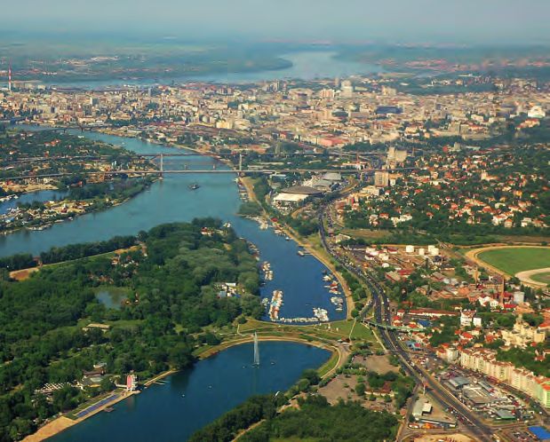
Country: Italy                     Region: Emilia Romagna
 4. Port of Ravenna
                                                                              Main cargo specialisation:
                                                                              Dry bulk, Ro-Ro cargo, containers
                                                                                     Characteristics of the Ravenna container terminal
The Port of Ravenna is positioned in the central-
north western side of the Adriatic Sea, in the                                    Total          Terminal          Maximum             Total           Container
Mediterranean basin. It is the main port of the                                  length            quay           vessel draft       terminal           stacking
                                                                                of quays          depth            allowed*            area             capacity
Emilia Romagna region, located in Northern Italy.                                  [m]             [m]                [m]              [m2 ]             [TEUs]
The port is a core node of the TEN-T network as
                                                                                 670 1            10.50 1            9.60 2         250,000 1          13,500 1
defined by Regulation EU 1315/2013. It belongs to
                                                                          *in all or part of the quay length
the Baltic-Adriatic Corridor as well as to the Baltic-
Adriatic Rail Freight Corridor – RFC5 and it also
                                                                          1
                                                                              Contship Italia S.P.A. official website (2019).
                                                                              Available at: https://www.contshipitalia.com/en (Accessed: 26 September 2019).
belongs to the Mediterranean Corridor.                                    2
                                                                              Port System Authority of the Central-Northern Adriatic Sea official website (2019).
Within the scope of the Baltic-Adriatic Corridor                              Available at: http://www.port.ravenna.it/ (Accessed: 26 September 2019).
development, the port is identified as primary
logistic platform by the Connecting Europe Facility
Regulation 1316/2013.
The Port of Ravenna is the only port canal in Italy.
The Candiano Canal is 14 km long and offers 14.5
km of operational quays, currently used by 27
terminal operators.
The maximum depth of the port is currently 11.5
m. The port is interconnected to the main road
and rail network. At present ten 10 terminals are
connected to railways.
The total area of the port is 21 km2 and its storage
capacity consists of more than 600 thousands m2,
1,350 thousands m2 yards and 1.3 million m3 of
storage tanks.                                                                                            Figure 4 - Port of Ravenna

                             Key bottlenecks identified in the local context analysis

       Market                 Infrastructural              Operational                         Institutional                           Innovation
 • Port activities           • Limited depth of the      • Operational barriers                                                    • Inability to provide
   sectorialization on         access canal and of the     affecting cross border                                                    seamless port-
   import of good (raw         Railway network: train      operations of long                                                        hinterland cargo
   materials) for the          length, axle load,          distance traffic flows                                                    visibility to operational
   Italian industry sector     Lauding gauge (RFI          between European                                                          actors and shippers
 • Scarce significance of      improvements ongoing)       Member States:
   the Port of Ravenna       • Inadequate capacity       • Communication
   in other segments of        of hinterland transport     between Infrastructure
   the maritime transport      networks                    Managers (IMs’) Traffic
   market i.e. container                                   Control Centres (TCCs)
   traffic and Ro-Ro                                       or among Railway
 • Low level of export                                     Undertakings (RUs) or
   volumes in terms                                        between RUs and IMs
   of finished goods                                       at the borders;
   produced by the                                       • Operational rules
   same industries that                                    between RUs and IMs
   are using the Port                                      at the borders”
   of Ravenna in other
   segments of the
   maritime transport
   market i.e. container
   traffic and Ro-Ro port
   for input purposes.

                                                                                                                                                                    9
Improved relation between the port and the Ceramic District
located in the regional hinterland
Overview for this traffic are, limited to some specific areas
(East Mediterranean and Black Sea countries, few
The Port of Ravenna serves the excellence residual volumes to Middle and Far East).
industry located in the Emilia Romagna Region
and Northern Italy, representing a gateway for the
dry bulk materials necessary for these industries.
Stakeholders involved
Considering the relatively high specialisation • Ravenna Port Authority
of the port and its strong integration with the • Freight Forwarders - GENERAL NOLI, JAS, DEL
manufacturing and industrial sectors of the local CORONA E SCARDIGLI, LEONARDI GROUP, SPINELLI,
and national economy, the plan was focused on DB SCHENKER, DSV, TRANSMEC
a specific manufacturing sector identified in the • Port Terminal operator – SAPIR, TCR
ceramic industry. The regional ceramic industry is
mainly concentrated within the “Ceramic District”, • Multimodal Transport Operators (MTOs)
a strategic area between the provinces of Modena • Sectorial Association (Confindustria Ceramica)
and Reggio Emilia (Emilia Romagna Region) located
about 140 km from the Port of Ravenna, which Key actions
concentrates about 82% of the national production Key Action n. 1: Implementation of a new
of tiles and slabs for flooring and ceramic coatings. scheduled service by using the “clay train” who
The Port of Ravenna has an important role both currently returns empty to Ravenna Port
in the importation of raw materials coming from The action consists in the development of a
Ukraine and Turkey, and for the exportation of scheduled train service for tiles containers in export
ceramic tiles, especially with Middle East/East-Med by using the existing service devote to the transport
countries destinations. Also, transport and logistics of clay (i.e. “clay train)” which currently connects
activities related to the production and distribution the Port of Ravenna to Dinazzano terminal about
of tiles constitutes an important service operated 20 times a week (4 connections/day), returning
by the port of Ravenna in favor of the Ceramic empty (only occasionally some wagon containers
District, e.g. the frequent rail connections with the are added).
terminal of Dinazzano, at the heart of the Ceramic
District. After a preliminary assessment with the rail
cargo operator based at the Dinazzano terminal,
operational conditions (in terms of equipment and
The issue operational feasibility and availability) have been
In consideration of the rail transport, raw materials evaluated in detail. According to this consultation,
for the ceramic industry resulted as one of the it is supposed that up to 10 additional wagons for
products determining unbalanced train services containers could be added to the returning clay
in terms of incoming and outcoming volumes. The train allowing to transport to Ravenna additional
“clay train” logistic service operates about 900 20ft. containers per train. In total, a new service
connections per year from the port of Ravenna would guarantee the transport of 4.000 TEUs/year,
to the Ceramic District – Dinazzano terminal partially covering the existing demand (it estimated
(corresponding to about 1 million tons/year), that about 5000 TEUs of ceramic tiles reach Ravenna
returning empty to Ravenna port. Containerized by truck each year).
rail services running between Dinazzano and The service allows a strong impulse to modal
Ravenna are infrequent and, moreover, are shift enabling the rail service to be always more
unscheduled, allowing road transport to be more convenient and attractive if compared to road
reliable and attractive for freight forwarders. As alternative, because of a reliable scheduling and
a result, the district exported about 5500 TEUs2 an increased frequency that would generate an
(corresponding to 120.000 tons) overseas via the additional demand (“critical mass”).
Ravenna Port, reaching the Port of Ravenna mainly It is important to underline that the action is subject
by road transport (about 90%) and only in small to the stipulation of commercial agreements and
part by train (about 10%) usually by means of 20ft. strategies between commercial stakeholders
containers. In addition, the destination countries (i.e. freight forwarders and transport operators)
10involved in the maritime and hinterland logistics Timescale implementation
chain, aimed at consolidating a proper critical
mass. Short term Mid-term Long term
(by 2020) (by 2027) (by 2034)
Key Action n. 2: Commercial actions for the
development of new connections and the Beginning and
strengthening of existing feeder services Key
completion of
Action 1
The action consists in a new commercial strategy Key Action 1
of the Port with the objective to involve shipping
lines in order to verify the possibility to implement Key Beginning of Completion of
new direct connections and services as well as Action 2 Key Action 2 Key Action 2
strengthen the existing ones.
Considering the sector of Ceramic tiles industry,
the primary role covered by the Port of Ravenna Funding sources
in accommodating needs in terms of demand Key Action 1
mainly occurs towards East Med destinations, as The funding sources for Key Action 1 are partially
only indirect connections to Middle East and Far private (MTOs/ Railway operators which make
East are possible and one or more transshipments investments and fully absorb the “train risk” + the
are required, with the consequent issues related ceramic industry, who can financially contribute to
to increased costs, transit times and risks (damage promote sustainability and modal shift initiatives)
to goods and missed correspondences at the port and partially public (Regional/State incentives for
of transhipment in case of delays). This situation, modal shift (e.g. L.R. 30/2019, Ferrobonus).
clearly, brings to the consequence that Transport
The funding sources for Key Action 2 are private
companies may chose different departing Ports
(Maritime/port terminals, Inland rail terminals/
as more competitive to Middle East and Far East
MTOs).
destinations.
The creation of new dialogues with shipping
companies is enabled by the involvement of Impact on Bottlenecks
stakeholders (in particular Port Authority, Port • Increase in the Incoming and outcoming
Terminal companies and Freight Forwarders) volumes (tons) of raw materials/ceramic tiles,
and takes into account the possibility to include over a timescale of 1 year after implementation
economic facilities. The latter point is justified of the new service, and their variation
according to the fact that is given the assumption compared to the previous year.
that new shipping lines services can generate
• Number of trains (inbound and outbound)
additional demand and improve port cargo
connecting the port of Ravenna with the
volumes. Aiming, then, for an increase in the port
ceramic district for raw materials/ceramic
attractivity both for the hinterland and for countries
tiles over a timescale of 1 year, their variation
markets (especially Middle East markets but also
compared to the previous year.
new markets such as Far East), it is searched for
more competitive services and optimal balancing • Improved integration of the Northern-Central
between transit times and costs Italian regions with the Adriatic Ionian basin
and the TEN- T network (Baltic Adriatic).
• New connections/new shipping lines/new
Aims markets (N.) supplied by the Port of Ravenna.
• Consolidating the existing relations between • Travel time and distance (hours; km) of train
the Port and its hinterland nodes by means services connecting the Port of Ravenna and
of an improved port attractiveness and Dinazzano, in relation to their difference in
competitiveness within the Mediterranean case of none, one or two shunting maneuvers.
Sea basin, as well as within the Northern and
Central Italian intermodal system.
• A further increasing the traffic volumes at the
port as part of its hinterland logistics chain
with reference to total traffic and internodal
traffic, including an increase in the modal share
of rail traffic accessing the ports’ terminals.
11Strengthening the last-mile connections and developing maritime
infrastructural improvements for canal depth, new terminals and quays
Overview Stakeholders involved
Maintaining an efficient and effective infrastructure • Emilia-Romagna Region
capable of serving the needs of the market • RFI S.p.A. - National Rail infrastructure manager
and accompany the evolution of the port and • Ravenna Municipality
maritime industry is a key element to keep a port • Ravenna Port Authority
competitive, especially in the mid and long-time • Inland Rail terminal operator Dinazzano Po
horizons. Among the actions aimed at promoting • Port terminal operator SAPIR
the integration between the Port and its hinterland • Port terminal operator TCR
surroundings, and with international networks
(TEN-T and Adriatic-Ionian basin), find place the Key actions
infrastructure bottlenecks affecting the freight
transport and logistics operations at the Port of Key Action n. 1: Renovation of rail/road
Ravenna. infrastructure and services for the accessibility
of the Ravenna Port
In particular, bottlenecks are related to the need
of deepening the draft of the port canal, expanding The action consists in the resolution of the scarce
the existing terminals and areas dedicated to accessibility to the port and last mile connections
logistics operations, and improving the last mile to the ports’ terminals which affect the transport
connections. time, costs and thus the overall attractivity of the
Port in favor of other contenders Ports. Moreover,
this is also a priority for the new TEN-T policy,
The issue the Work Plan of the Baltic-Adriatic corridor, the
The port is currently constrained by a low draft Deployment Plan for the Motorways of the Sea as
of the harbour which limits the efficiency of the well as the Connecting Italy (Connettere l’Italia)
terminal operations to all types of cargo, and strategy, and the Strategic National Plan for Ports
particularly dry bulks. The relatively limited depth and Logistic (Piano Strategico Nazionale dei Porti e
of the access canal, whose maximum draught is della Logistica).
10.5 m, and of the quays, in some of which (some
of the mains) the draft is limited to just above 9
m, is suitable to those ships whose dead-weight
tonnage (DWT) is lower than 20-25 thousand tons
(approximatively the segment of the Handysize
ships), corresponding to around 30% units (10% if
measured in DWT) of the world fleet.
The use of larger ships is subject to a reduction
of the maximum permissible load, which can be
achieved through a prior unload to a different port.
Such constraint reduces the transport efficiency and
increases the related costs, with a negative impact
on the competitiveness of the Ravenna Port.
In parallel, some issues in the rail infrastructures
are impacting on the last-mile connectivity between
the Ravenna port and its hinterland.
In particular, interventions relating to the
adjustment of the gauge, the length and the
axle load of the railway lines interconnecting the
port with the main logistics nodes located in the
Emilia Romagna Region and more generally in the
catchment area of the port are needed, to be in
line with the standards required by the Regulation
EU 1315/2013. Figure 5 - Port last mile connections
12About rail last mile connections, the objective criticalities in relation to the peak traffic volumes
is again to ensure the ports and their terminals in summer months, particularly on those sections
respect as far as possible the technical standards that distribute the traffic coming from the A14 dir
in terms of: between the North and the South area of Ravenna.
• Electrification; Moreover, solutions to mitigate the impact of road
• Gauge; transport on the respective urban areas are also
• Axle load; needed.
• Train length. More in details, the following actions are foreseen:
Furthermore, there is the need to upgrade and • Works for the improvement of road accessibility
further develop the existing rail infrastructure to the port are also planned for the upgrade of
within and in the immediate surroundings of the the SS 309 dir and its interconnection to the SS 16
port areas. Improvements are required also in view • Upgrade of SS 16;
of future traffic increase. The following issues have • the improvement of the SS 67 (included in the
been recognized: current Framework Agreement between the
• Freight terminal close to its capacity limit; Italian Government and the National Highway
• Interference with passenger train station; Agency).
• Low speed and long travel time to port • Improvement of the Cesena-Ravenna-Mestre
terminals; highway interconnecting Venezia to Ravenna,
• Road – rail interference: level crossings to Rome. This project is currently under
(no barriers); consideration, assumed to be possibly developed
• Unavailability of hazardous cargo yards. under a PPP scheme
In this framework, five planned works are included Key Action n. 2: Maritime-side infrastructural
in this action: improvements for canal depth, new terminals
No. Description and quays (Ravenna Port Hub project)
1 Elimination of a level crossing This action is based on the implementation of
(Via Canale Molinetto) the Ravenna Hub Project, aimed at resolving
2 Teodorico Bridge: Upgrading to P/C80 the bottleneck consisting in limited maritime
infrastructure, as well as guaranteeing port
3 Extension of the shunting track
to the new container terminal
competitiveness. The first stage of the Ravenna
Port Hub project (Figure 4), already under
4 Strengthening of the North shunting track:
implementation, includes dredging the canals
• upgrade of the rail yard to freight terminal;
• direct link to North bound main line into operation
(marine, Candiano and Baiona) and the front port
area, reaching a maximum draft of 11.8 m (+1m).
5 Strengthening of the South shunting track:
This improvement will allow the access of full
• electrification and equipment of the track;
• upgrade of the rail yard ti freight terminal
loaded vessels with 30-35 thousand tons, which
corresponds to load capacity that is 50% higher
Regarding road last mile connections, as the than the current limit. This stage also envisages the
road infrastructure requires modernization, the upgrade of the existing quays and the construction
national planning envisages interventions for the of the New container/multipurpose terminal quay,
upgrade of the Ravenna’s ring road, which shows as well as the re-use of dredged materials to raise
Figure 6 - Road sections interested by the planning upgrades Figure 7 - Stage I of the Ravenna Port Hub project
13the level of areas located in the proximity of the 175 € million for the upgrade of the SS 309 dir
port, in order to develop them as logistics platforms. and its interconnection to the SS 16, about 72 €
The second stage of the project (Figure 5), instead, million for the upgrade of the SS 16; €20 million
foresees a draft of -12,50/-14,50 meters in the for the improvement of the SS 67 (included in
superior parts of the Port, and up to -15,00 m in the current Framework Agreement between the
the approaching canal. Italian Government and the National Highway
Agency).
Aims Key Action2
• Consolidating the existing relations between The funding sources are public (State/EU funds) and
the Port and its hinterland nodes by means correspond to about 235 € million. In particular, a
of an improved port attractiveness and part of the amount was awarded with CEF funds
competitiveness within the Northern and (2017-IT-TM-0044-W) for an amount of about 37 €
Central Italian intermodal system. million.
• A further increasing the traffic volumes at the
port as part of its hinterland logistics chain Impact on Bottlenecks
with reference to total traffic and internodal The realization of the Ravenna Port Hub project
traffic, including an increase in the modal share will allow to keep the port competitive and to
of rail traffic accessing the ports’ terminals. overcome the possible progressive marginalization
• Improved port attractiveness and of the seaport due to the increasing vessel size of
competitiveness within the Mediterranean Sea the world fleet and the existence of higher drafts
basin, overcoming the possible progressive available in other European ports that register dry
marginalization of the seaport due to the bulks traffic volumes higher than 10 million tons.
increasing vessel size of the word fleet and the The main impacts related to a disruptive improvement
existence of higher drafts available in other of port accessibility and the development of
European ports that register dry bulks traffic an “integrated network” between maritime
volumes higher than 10 million tons.. infrastructure and land-based infrastructure,
consist of an increase in the total traffic throughput
Timescale implementation of the port and the hinterland logistics chain with
Short term Mid-term Long term reference to total traffic and intermodal traffic,
(by 2020) (by 2027) (by 2034) including an increase in the modal share of rail
traffic accessing the ports’ terminals.
Completion of
Completion of The impacts related to accessibility have also an
the works for
the works for the indirect impact on the overall competitiveness
Key rail last mile
improvement of the port-hinterland system. At last, the
Action 1 connections
of road last mile enhancement of this infrastructure is expected to
to the ports’
connections provide an improved environmental performance
terminals
of the local logistics chain in terms of decrease of
Completion of road traffic in favor to the rail mode of transport,
Beginning the works related Completion as well as a reduction in the travelled distances for
Key of the works to Stage 1 – of the works
the road freight transport addressed to the Port. In
Action 2 related to Beginning of the related to
this way, the negative externalities related to road
Stage 1 works related to Stage 2
Stage 2 transport, such as GHG and noise emissions, will be
reduced, while at the same time accommodating
growing demand.
Funding sources
Indicators are being evaluated since the beginning
Key Action 1 of the activities (time 0), during the implementation
The funding sources are public (State/EU funds). of the actions and at the total completion of the
More in detail: actions.
• the works for the improvement of rail
accessibility (considering the interventions Deliverable D.T2.2.1 – ISTEN Local action plan for
listed in the section “Key Actions” are the Port of Ravenna describes in detail the planned
quantified in about 70 € million (RFI SpA); measures, their design and the stakeholders involved.
It also provides more detailed description of the
• the works for the improvement of road
characteristics of each action.
accessibility to the port are quantified in about
14Country: Italy Region: Calabria
5. Calabria Region
Main cargo specialisation:
Containers and Ro-Ro (Gioia Tauro)
The Calabrian port system consists of 39 ports of Liquid bulk (Vibo Valentia)
different sizes and functions, distributed along Liquid & dry bulk (Crotone)
the 780 km coastline, partly along the Tyrrhenian Dry bulk (Corigliano)
side and partly along the Ionian one. The main
commercial ports are Gioia Tauro, Vibo Valentia, Characteristics of the Gioia Tauro container terminal
Crotone and Corigliano Calabro. Total Terminal Maximum Total Container
The port of Gioia Tauro is located about 56 km north length quay vessel draft terminal stacking
from Reggio Calabria town. The “logistic system” of of quays depth allowed* area capacity
[m] [m] [m] [m2] [TEUs]
Gioia Tauro is spread over a flat area of about 7
million m2 of which the port areas cover an area of
3,395 14,00-18,00 n.a. 1,700,000 67,000
3,200,000 m2. The port has a channel configuration
with an internal water surface of 1,800,000 m2
located parallel to the coast, on which three main
quays are developed (North, Eastern and West
quays).
The port of Gioia Tauro, with a throughput
about 3 millions of TEU/year, is one of the main
transhipment port in the Mediterranean sea
and the first port in Italy considering only TEU
traffics (30% of the 10 million TEUs in Italy). It is
a core network port belonging to Trans European
Network and in particular to: i) the Scandinavian-
Mediterranean TEN-T infrastructural corridor, that
is implementing and is planned to complete in the
2030 (TEN T, corridor 5); and ii) the Central North-
South Rail Freight commercial Corridor, that will be
implemented by the end of 2015 (RFC, corridor 3).
The ports of Vibo Valentia, Crotone, and Corigliano
serve mainly a local market, moving goods by
specific production and consumption of the Figure 8 - Port of Gioia Tauro
surrounding territories. Source: Port Authority of Gioia Tauro
Key bottlenecks identified in the local context analysis
Market Infrastructural Operational Institutional Innnovation
• Port activities • Inadequacy of the • Operational difficulties • Scarcely effective • Lack of stable
specialization on a regional rail network related to the decision-making relationships among
single sector • Inadequacy of last mile inadequacy of the port system characterized different stakeholders
• Lack of commercial connections (rail, road) infrastructure and road by conflicts of • Age of handling
connections with the • Inadequacy of and rail links with the skills, slowness and equipment and
Balkan and Eastern port and logistics hinterland bureaucratic delays information and
Mediterranean infrastructure” • Lack of services (rail • Presence of different communication
countries and road operators) bodies and institutions systems
for connection to the (Ministries, Port
hinterland Authority, Consortium
• Poor competitive for industrial areas,
capacity (high time Region, Railways, etc.)
and high costs) in
intermodal transfers
(sea-road and sea-rail)
15Calabria Region as competitive European terminal port
for the Silk Maritime Road
Overview maritime distances, ports of considerable capacity
already operational. This solution could allow
Logistics chains are being modified and commit
for lower and reasonable investments, slightly
many States to sustain substantial investments.
improve rail transport, avoid heavy impacts on the
Some large infrastructural works have been
environment and on the tourism industry and would
completed, others are nearing completion, and
allow the entire Italian region to be linked from the
others are still at the planning stage. In recent
south.
years, the Chinese government committed to the
construction of two commercial corridors, one
maritime and the other by rail (Silk Roads; BRI –
Stakeholders involved
Belt and Road Initiative) in order to reach the main • national, regional government authorities;
European market at lower costs. To achieve this • authorities of Reggio Calabria Metropolitan City;
project, significant investments have been planned, • Gioia Tauro Port Authority;
including the construction and management of • private stakeholders as category representatives
a new commercial port in North Adriatic Region of the business and production field.
capable of hosting large container ships (18-24.000
TEUs), with a commitment of the order of 2 billion Key actions
euros. On the rail infrastructure side, the planned
The key actions that should be implemented in
railway route starts from Xian through rural China,
order to make Calabria the European terminal
touches Teheran in Iran, arrives in Turkey, passing
for the new silk road can be summarized in the
through Bosphorus Straits (Istanbul), and has the
following points
city of Duisburg in Germany the terminal in Europe.
Logistics chains are being modified and commit • institutional commitment to promote the
many States to sustain substantial investments. terminal of the silk road in Calabria and useful
actions to give continuity to the intermodal
The issue route through Calabria, also with specific
funding;
The design of Maritime Silk Road is expected to • adjustment of integrated logistics services
pass through Adriatic Sea, ending in Venice or supply to make Calabria the real gravity center
Trieste, where the freights should be moved on of freight flows between Asia and Europe,
trains towards Central Europe. However, this realizing the competitive advantage deriving
solution may underestimate a series of issues. The from the position;
hypothesis of an offshore platform in the Adriatic
• territorial marketing activities aimed to
Sea has been considered, but it seems to have
include the Calabrian ports into national and
little chance of success due to the investment costs
international circuits and to attract transport
and environmental risks. Furthermore, navigation
and logistic demand;
along the Adriatic corridor for mother-ships would
• measures related to infrastructures, nodes and
be very expensive for shipping companies and
services to adapt regional transport systems
emissions could have negative effects on the marine
to the needs of an intermodal intercontinental
ecosystem. Transport times would also increase due
corridor (see next sections);
to longer routes and longer interchange times.
An alternative solution, more profitable and • definition of an industrial and macro-regional
feasible, is proposed and described: the European development plan with a medium-term horizon
continental terminal could be the Calabria Region that includes economic and financial actions
(with its port system, based on a large container with international agreements relating to
terminal - Gioia Tauro), with a possible integrated commercial exchanges and collaborative
expansion of the port system towards Puglia along projects in the scientific and industrial fields
the Ionian corridor (ports of Crotone, Corigliano,
Taranto) and towards Sicily (ports of Messina, Aims
Augusta and Catania). The advantages should be • Making the Calabrian port system the European
seen from a comparative perspective: greater continental terminal on the route of the
Euro-Mediterranean geographical centrality, less Maritime Silk; with a possible integrated
16expansion of the port system along the Ionian • EU grants/subsidies;
corridor (Crotone, Corigliano) towards Puglia • national and regional government subsidies;
(Taranto).
• private investments.
Timescale implementation Impact on Bottlenecks
The duration of the activities planned for the The main limit of the port of Gioia Tauro is
design and implementation of this action is represented by the fact that it is a port exclusively
estimated at 3 years. Such a period is deemed linked to transhipment and therefore vulnerable
necessary in order to elaborate and complete the to the decision-making system of the major
institutional path as well as to activate appropriate international ocean carriers and the competition of
agreements among the interested parties. Of other Mediterranean ports. The mono-functionality
course, the implementation of the action, which of the port did not allow to extend to the surrounding
pertains to the market cluster, depends heavily on territory the benefits of an economic nature, which
the construction of infrastructures necessary to get remained limited to the narrow port area. Large
strong the intermodal transport system both local container ships arrive in the port, unload their
and national level. containers, which are loaded on feeder ships that
Furthermore, the action is strictly connected to leave for local distribution.
the improvement of the operation of the regional A complex of activities that takes place within the
port system which should take place through the port area without any connection with the economic
activation of highly advanced logistics services. and social activities of the Hinterland. The inclusion
of the Gioia Tauro node within the New Silk Road
Funding sources as well as allowing significant savings in terms of
For the implementation of the action, the need of money and time for the distribution of goods to
25 Million € is approximately estimated (excluding the north and central Europe, would guarantee
measures related to infrastructures, considered in the port greater prospects for development and
other specific Action). Possible sources of funding expansion of its catchment area and therefore of
could be: its hinterland.
Hub and Spoke System in Euro-Mediterranean Area
for Ro-Ro traffic with hub in Calabria Region
Overview territory, spreads throughout the basin. Currently,
the services of SSS in the Western Mediterranean
The concept of Short Sea Shipping (SSS) is specified
are all attested on couples of ports, and mostly
in the communication n. 317 of 1999, in which the
on direct connections, without intermediate
European Commission defines SSS as “the movement
stopovers.
of goods and passengers by sea between ports
located in geographical Europe or between these On the Eastern side, the Ro-Ro maritime transport
ports and ports located in countries outside Europe network is less dense, developed mainly within the
with a sea coast closed to the borders Europe”. Adriatic Sea with connections between the Balkan
area and the Italian peninsula; however, there are
The motorways of the sea represent a specific type
also connections among Turkey, Eastern Europe and
of SSS. They are freight transport services by sea,
Italy
scheduled, high frequency, reliable, integrated
in door to door logistic chain through intermodal
transports. These services are realized using Ro-Ro The issue
(Roll on – Roll off) ships, that are loaded and unloaded At the geo-economic level, the Mediterranean
with horizontal operations and haul specific load interfaces the Atlantic and North European markets
unit: trailers (unaccompanied transport) and trucks on the one hand and the Asian and African markets
(accompanied transport). on the other. For this reason, the centrality of the
The Mediterranean ports equipped for Ro-Ro basin in an international context is a strong factor
services are about 60, and a dense network of routes of attractiveness for public and private investments
(88 lines), which are being integrated with the in the transport and logistics fields,
17which continue to grow despite some critical social basin with Hub identified in the Calabria Region,
and political situations. The Mediterranean is a can be summarized in the following points:
privileged transit route for containerized traffic, • institutional commitment to promote the
but it is also a very significant area for short- realization of Ro-Ro maritime transport hub in
distance Ro-Ro traffic, particularly in the North- the Calabria Region;
South direction. This situation determines new
• joint venture among maritime transport
market needs that require, not only transport
operators in the Mediterranean basin aimed
services, but also integrated logistics services that
at changing the configuration of the network
presuppose the existence and functionality of an
(transition from a point to point network to a
intermodal network system capable of projecting
hub & spoke network) through the synergic use
the Mediterranean basin regions at the center
of resources;
of Europe. In particular, the market requires
integrated services that also include processes of • planning, design and activation of integrated
freight handling and transformation, to generate logistics services for groupage/degroupage
added value and minimizing monetary costs and activities of Ro-Ro loads;
logistic times. • regulatory policies, guidelines and support for
Hence the hypothesis of a hub and spoke network Ro-Ro maritime transport;
structure to realize an integration between the TEN-T • activation of new Ro-Ro lines for the connection
networks and the Ro-Ro sea routes coming from the between the Balkan peninsula and Calabria
southern and eastern shores of the Mediterranean and the latter and the west coast of the
in order to produce significant economies both for Mediterranean (Spain).
transport operators and users. Regarding the last point, below is an example of
a Ro-Ro navigation line that could be activated
Stakeholders involved during the project (Figure 9). The line provides a
• national, regional government authorities; Mediterranean East-West cross connection crossing
• authorities of Reggio Calabria Metropolitan City; Calabria region. In particular, it is possible to
• local municipalities; plan and activate an annual regular shipping line
with Ro-Pax ship to connect the Greek town of
• port authority;
Igoumenitsa and the Calabrian port of Corigliano
• private stakeholders as category representatives Calabro for a continuation by road to Gioia Tauro
of the business and production field. and boarding for Valencia. This new route may
be required as a “short bridge”. The name comes
Key actions from the existing “Long Bridge” line operated by
The key actions for the realization of a Hub & Spoke Grimaldi Lines and connecting Patras-Igoumenitsa-
system for Ro-Ro traffic within the Mediterranean Brindisi-Civitavecchia-Barcelona. The line connects
Figure 9 -
Comparison between
the Long Bridge
and Short Bridge
Source:
UNIMED elaboration
18You can also read