ADDRESSBASE PLUS ISLANDS TECHNICAL SPECIFICATION
←
→
Page content transcription
If your browser does not render page correctly, please read the page content below
ORDNANCE SURVEY GB

 ADDRESSBASE PLUS ISLANDS
 TECHNICAL SPECIFICATION

OFFICIAL
v1.1 March 2021
Page 1 of 41
ADDRESSBASE PLUS ISLANDS - TECHNICAL SPECIFICATION                                                   OFFICIAL
March 2021

Version History

Version       Date                  Description
1.0           03/2016               Initial version.
1.1           03/2021               Updated formatting.

Purpose of this Document

This is the Technical Specification for the AddressBase Plus Islands product. This Specification provides
greater insight into these products and their potential applications. For information on the contents and
structure of AddressBase family of products, refer to the Overview and the Getting Started Guide.

The terms and conditions on which AddressBase Plus Islands is made available to you and your organisation
are contained in that Ordnance Survey customer contract. Please ensure your organisation has signed a
valid current customer contract to be able to use AddressBase Plus Islands.

We may change the information in this Specification at any time, giving you the notice period set out in
your contract.

We do not accept responsibility for the content of any third-party websites referenced or accessed in or
through this Specification.

This document has been screened according to Ordnance Survey's Equality Scheme. If you have difficulty
reading this information in its current format and would like to find out how to access it in a different
format (braille, large print, computer disk or in another language), please contact us on:
+44 (0)3456 05 05 05.

Copyright in this Guide

© Ordnance Survey Limited 2021. This Specification (including for the avoidance of doubt, any mapping
images reproduced within it) is protected by copyright and apart from the rights expressly granted within
this document to use the content, all rights are reserved. Any part of this Specification may be copied for
use internally in your organisation or business so that you can use AddressBase Plus Islands under the
terms of your licence (but not otherwise).

No part of this Specification may be reproduced or transmitted in any form or by any means (including
electronically) for commercial exploitation, onward sale or as free promotional material without getting the
written consent of Ordnance Survey beforehand.

AddressBase Plus Islands contains data created and maintained by Northern Ireland, Isle of Man and
Channel Islands Local Government as well as Royal Mail:

•   PAF data are copyright material of Royal Mail Group Limited.

•   Northern Ireland data provided by Land & Property Services © Pointer copyright and/or database right
    2021.

•   Channel Island Address information is the intellectual property of The States of Guernsey and/or The
    States of Jersey. Copyright © 2021 States of Guernsey / Jersey.

•   Address information derived from Isle of Man Government Property Database. © Crown Copyright,
    Treasury, Isle of Man.

© Ordnance Survey Ltd 2021                                                                         Page 2 of 43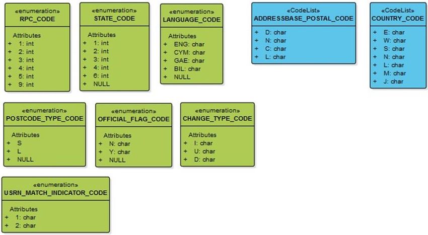
ADDRESSBASE PLUS ISLANDS - TECHNICAL SPECIFICATION                                            OFFICIAL
March 2021

Trademarks

Ordnance Survey, OS, the OS Logos, AddressBase are registered trademarks and AddressBase Plus Islands
is a trademark of Ordnance Survey, Britain’s mapping agency.

PAF, PO Box, Post Office and Royal Mail are registered trademarks of Royal Mail Group Ltd.

Contact details

https://www.ordnancesurvey.co.uk/contact-us.

© Ordnance Survey Ltd 2021                                                                   Page 3 of 43
ADDRESSBASE PLUS ISLANDS - TECHNICAL SPECIFICATION                                                                                                                             OFFICIAL
March 2021

Contents
1.      Introduction............................................................................................................................... 5
1.1     Available Formats ........................................................................................................................................................ 5
1.1.1   CSV ................................................................................................................................................................................. 5
1.1.2   GML ................................................................................................................................................................................ 6
1.2     Supply and update ....................................................................................................................................................... 7
1.3     Coordinate reference system .................................................................................................................................. 8
1.4     Unique Property Reference Number ..................................................................................................................... 8
2.      AddressBase Plus Islands Structure ........................................................................................ 9
2.1     Structure........................................................................................................................................................................ 9
2.1.1   Model overview CSV .................................................................................................................................................. 9
2.1.2   Model overview GML............................................................................................................................................... 11
2.2     Features ....................................................................................................................................................................... 13
2.3     Code lists and Enumerations .................................................................................................................................. 29
3.      CSV to GML Mapping ............................................................................................................. 34
4.      Change-only update (COU) Supplies .................................................................................... 37
4.1     Archiving ...................................................................................................................................................................... 37
5.      Example Record ...................................................................................................................... 38
5.1     CSV Supply .................................................................................................................................................................. 38
5.1.1   Original feature – AddressBase Plus Islands CSV .............................................................................................. 38
5.1.2   COU feature – AddressBase Plus Islands CSV .................................................................................................. 38
5.2     GML Supply................................................................................................................................................................. 38
5.2.1   Original feature – AddressBase Plus Islands GML............................................................................................. 38
5.2.2   COU feature – AddressBase Plus Islands GML ................................................................................................. 39

© Ordnance Survey Ltd 2021                                                                                                                                                   Page 4 of 43
ADDRESSBASE PLUS ISLANDS - TECHNICAL SPECIFICATION                                                       OFFICIAL
March 2021

1.         Introduction
AddressBase Plus Islands contains current properties including addresses sourced from local authorities,
Ordnance Survey and Royal Mail, all provided with an UPRN (Unique Property Reference Number), for
Northern Ireland, Channel Islands and the Isle of Man.

The product enables the end-user to locate an address or property on a map using either X, Y coordinates
supplied on a British National Grid or Latitude and Longitude coordinates provided on an ETRS89
projection.

Please note this product was designed to allow current customers of AddressBase Plus to add this product
(AddressBase Plus Islands) to their current data holdings. This means there are columns in the schema of
this product which will never be populated. These are identified on the appropriate pages throughout this
specification document.

1.1        Available Formats
The AddressBase Plus Islands product will be distributed as a comma-separated values (CSV) file or
Geography Markup Language (GML) version 3.2. Both of these formats can either be supplied as a full
supply or a change-only update (COU) supply.

1.1.1      CSV
The CSV supply of AddressBase Plus means:

•    There will be one record per line in each file
•    Fields will be separated by commas
•    String fields will be delimited by double quotes
•    No comma will be placed at the end of each row in the file
•    Records will be terminated by Carriage Return / Line Feed
•    Double quotes inside strings will be escaped by doubling

Where a field has no value in a record, two commas will be placed together in the record (one for the end
of the previous field and one for the end of the null field). Where the null field is a text field, double quotes
will be included between the two commas, for example, - , “”,

AddressBase Plus CSV data will be transferred using Unicode encoded in UTF-8. Unicode includes all the
characters in ISO-8859-14. Some accented characters are encoded differently.

The transfer will normally be in a single file, but the data can be split into multiple files using volume
numbers. Most files will only be split where there are more than one million records.

The header row for the CSV is supplied separately and can be downloaded from the product support
pages.

© Ordnance Survey Ltd 2021                                                                              Page 5 of 43
ADDRESSBASE PLUS ISLANDS - TECHNICAL SPECIFICATION                                                  OFFICIAL
March 2021

1.1.2     GML
The GML Encoding standard is an Extensible Markup Language (XML) grammar for expressing geographical
features. XML schemas are used to define and validate the format and content of GML. The XML
specifications that GML is based on are available from the World Wide Web Consortium (W3C) website:
http://www.w3.org. More information can be found in the Open Geospatial Consortium (OGC) document,
Geography Markup Language v3.2.1: https://portal.ogc.org/files/?artifact_id=20509. The GML 3.2.1
specification provides a set of schemas that define the GML feature constructs and geometric types. These
are designed to be used as a basis for building application-specific schemas, which define the data content.

A GML document is described using a GML Schema. The AddressBase Plus Islands schema document
(addressbaseplus.xsd) defines the features in AddressBase Plus GML. This is available on the GeoPlace
website at: http://www.geoplace.co.uk/addressbase/schema/2.1/addressbaseplus.xsd.

It imports the GML 3.2.1 schemas which rely on XML, as defined by W3C at:
https://www.w3.org/XML/1998/namespace.html.

The application schema uses the following XML namespaces, for which definitions are available as given
here:

Prefix    Namespace Identifier                            Definition Available at
gml       http://www.opengis.net/gml                      http://schemas.opengis.net/gml/3.2.1/gml.xsd

          http://www.w3.org/2001/XMLSchema-               Built into XML –
xsi
          instance                                        http://www.w3.org/TR/xmlschema-1/
xlink     Xlink – http://www.w3.org/1999/xlink            http://www.w3.org/1999/xlink.xsd

Information about Unicode and UTF-8, the character encoding we have chosen, is available on the Unicode
Consortium website: http://www.unicode.org/.

Features
Each feature within the AddressBaseSupplySet:FeatureCollection is encapsulated in the following member
element according to its feature type:

Member Element                                  Feature Type

                            Address

The UPRN of the feature is provided in the XML attribute of the gml:id

………………..

See Section 5.2 for specific GML examples.

© Ordnance Survey Ltd 2021                                                                        Page 6 of 43
ADDRESSBASE PLUS ISLANDS - TECHNICAL SPECIFICATION OFFICIAL March 2021 Envelope In the GML supply, you can determine the extent of your supply by the . For example: 82643.6 5333.6 655989 657599.5 1.2 Supply and update AddressBase Plus Islands will be supplied as non-geographic chunks only. This is a way of dividing up the data into chunks that are supplied in separate volumes, which have a fixed maximum amount of records. The supply is not supplied with any reference to the geographic position of records. Customers are able to take the AddressBase Plus Islands product as a Full Supply or Change Only Update (COU) supply. Unzipped files The filename will be constructed as follows: • productName_supply_ccyy-mm-dd_vvv.format Where: ProductName is AddressBasePlus_ISL supply is defined as FULL or COU ccyy-mm-dd is the date the file was generated vvv is the volume number of the file format is the format of the files received, for example, CSV or GML For example: • AddressBasePlus_ISL_FULL_2013-05-28_001.gml (GML full supply) • AddressBasePlus_ISL_COU_2013-05-28_001.csv (CSV COU supply) Zipped files If the data has been provided in a zip file, the filename will be constructed as follows: • productName_supply_ccyy-mm-dd_vvv_format.zip For example: • AddressBasePlus_ISL_FULL_2013-05-28_001_gml.zip (GML full supply zipped) © Ordnance Survey Ltd 2021 Page 7 of 43
ADDRESSBASE PLUS ISLANDS - TECHNICAL SPECIFICATION                                                    OFFICIAL
March 2021

1.3        Coordinate reference system
AddressBase Plus Islands has two coordinate reference systems (CRS) present within the data:

1. British National Grid (BNG)
2. European Terrestrial Reference System 89 (ETRS89)

BNG uses the OSGB36 geodetic datum and a single Transverse Mercator projection for the whole of
Great Britain. Positions on this projection are described using Easting and Northing coordinates in units of
metres. The BNG is a horizontal spatial reference system only; it does not specify a vertical (height)
reference system.

ETRS89 is the EU recommended frame of reference for European data and is represented as Latitude and
Longitude values. ETRS89 is a horizontal spatial reference system only; it does not specify a vertical (height)
reference system.

View our guide to coordinate systems in Great Britain.

1.4        Unique Property Reference Number
A UPRN is a unique numeric identifier for every addressable location. The UPRN is the persistent identifier
providing consistency across the AddressBase product range.

Each address record has a UPRN, assigned by Local Authorities, GeoPlace or Ordnance Survey depending
on the type of address. This is the primary key of the AddressBase Plus Islands product.

Throughout its lifecycle, information on the address of a property can change. This may be due to a change
of name, change of use, or the eventual demolition of the property. Independent of any changes being made
the UPRN associated to an address is never changed, meaning the unique identifier remains persistent and
reliable.

© Ordnance Survey Ltd 2021                                                                           Page 8 of 43
ADDRESSBASE PLUS ISLANDS - TECHNICAL SPECIFICATION OFFICIAL
March 2021
2. AddressBase Plus Islands Structure
AddressBase Plus is structured as a flat file. The data structure in this document is described by means of
Unified Modeling Language (UML) class diagrams and accompanying tables containing text.
2.1 Structure
The AddressBase Plus product is constructed as per the following UML diagrams.
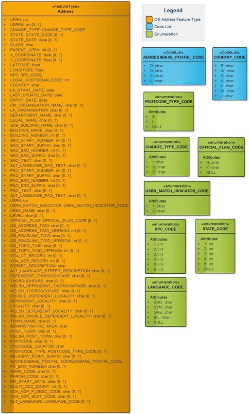
2.1.1 Model overview CSV
Figure 1: High level data model representing the address feature (CSV)
AddressBase Plus Islands CSV
The address of a property or object which is defined as the main / preferred
Definition: address by Pointer, Isle of Man Property database, Channel Islands Address
File (CAF), Ordnance Survey or Royal Mail.
The UML model of AddressBase Plus Islands in CSV format can be seen in Figure 2. In the UML diagram,
classes from the Ordnance Survey product specification are coloured orange; all code lists are coloured
blue, while enumerations are coloured green.
© Ordnance Survey Ltd 2021 Page 9 of 43ADDRESSBASE PLUS ISLANDS - TECHNICAL SPECIFICATION OFFICIAL
March 2021
Figure 2: UML model showing AddressBase Plus Islands Feature type,
Enumerations and Code lists for the CSV supply
© Ordnance Survey Ltd 2021 Page 10 of 43ADDRESSBASE PLUS ISLANDS - TECHNICAL SPECIFICATION OFFICIAL
March 2021
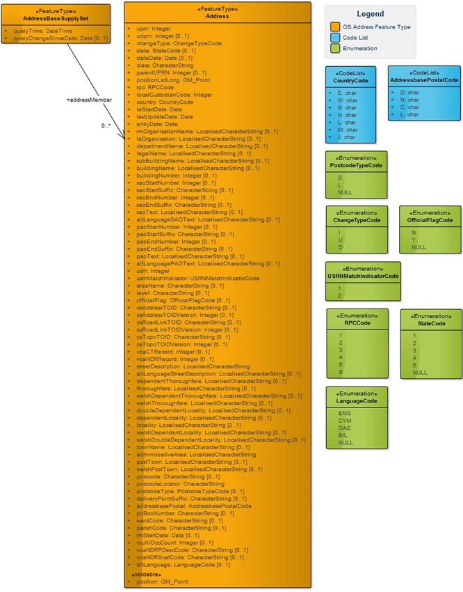
2.1.2 Model overview GML
Figure 3: High Level data model representing the address relationships (GML)
AddressBase Plus Islands GML
The address of a property or object which is defined as the main / preferred
Definition: address by Pointer, Isle of Man Property database, Channel Islands Address
File (CAF), Ordnance Survey or Royal Mail.
The UML model of AddressBase Plus Islands in GML format can be seen in Figure 4. In the UML diagram,
classes from the Ordnance Survey product specification are orange, all code lists are coloured blue and
enumerations are green.
Please note as the attribute ‘position’ is voidable this is displayed at the bottom of the UML model, but this
is not where it will be provided in terms of ordering in the product supply. Please see the following
attribute tables to confirm the attribute ordering.
© Ordnance Survey Ltd 2021 Page 11 of 43ADDRESSBASE PLUS ISLANDS - TECHNICAL SPECIFICATION OFFICIAL
March 2021
Figure 4: UML model showing AddressBase Plus Islands Feature Types, Enumerations and Code Lists for the GML supply
© Ordnance Survey Ltd 2021 Page 12 of 43ADDRESSBASE PLUS ISLANDS - TECHNICAL SPECIFICATION OFFICIAL
March 2021
2.2 Features
This section describes the features (one for CSV and two for GML) which make up the AddressBase Plus
product, giving the following information about each attribute:
Name and Definition: The name of the attribute and what it is describing.
Condition: A condition associated with this attribute. (Optional).
Attribute Type: The nature of the attribute, for example a numeric value or a code list value.
Multiplicity: Describes how many times this element is expected to be populated in the data. An attribute
may be optional or mandatory within the AddressBase Plus product. These are denoted by:
• ‘1’ there must be a value
• ‘0..1’ population is optional but a maximum of one attribute will be returned.
These values may be used in combination.
The tables which follow in this Technical Specification use orange for a feature type, blue for a code list and
green for enumerations.
Address
GML: uprn CSV: UPRN
Definition:
Unique Property Reference Number (UPRN) assigned by the data provider or Ordnance Survey.
Source: Contributing Local Authority / Ordnance Survey
Type: Integer Size: 12 Multiplicity: [1]
GML: udprn CSV: UDPRN
Definition:
Royal Mail’s Unique Delivery Point Reference Number (UDPRN).
Source: Royal Mail
Type: Integer Size: 8 Multiplicity: [0..1]
GML: changeType CSV: CHANGE_TYPE
Definition:
Type of Record Change – Please see Section 4 for more information.
Note:
If you are receiving a Full Supply, all records will be provided as an ‘I’ – Insert.
Type:
Size: 1 Multiplicity: [1]
ChangeTypeCode
GML: state CSV: STATE
© Ordnance Survey Ltd 2021 Page 13 of 43ADDRESSBASE PLUS ISLANDS - TECHNICAL SPECIFICATION OFFICIAL
March 2021
Definition:
A code identifying the current state of the property.
Source: Contributing Local Authority / Ordnance Survey
Type: StateCode Size: 1 Multiplicity: [0..1]
GML: stateDate CSV: STATE_DATE
Definition:
Date on which the property achieved its current state in the real world.
Source: Contributing Local Authority
Condition:
State Date must be present if State is present.
Type: Date Multiplicity: [0..1]
GML: class CSV: CLASS
Definition:
Classification of the address record, depicting its primary use.
Source: Contributing Local Authority / Ordnance Survey
Notes:
Please see the Ordnance Survey website for a lookup table between the classification code used in
product and the textual description.
Type: GML – CharacterString
Size: 6 Multiplicity: [1]
CSV - char
GML: parentUPRN CSV: PARENT_UPRN
Definition:
UPRN of the parent record if a parent child relationship exists.
Source: Contributing Local Authority / Ordnance Survey
Type: Integer Size: 12 Multiplicity: [0..1]
GML: position CSV: X_COORDINATE, Y_COORDINATE
Definition:
A value in metres defining the x and y location in accordance to the British National Grid.
Source: Contributing Local Authority/Ordnance Survey
Condition:
X_COORDINATE and Y_COORDINATE (position) must be populated if COUNTRY = ‘M’
Notes:
The multiplicity of this column is [1] for GML and [0..1] for CSV and. This is because position is
VOIDABLE in GML but this functionality is not possible in CSV. Please see UML models in Section 2.
Size:
Type: GML – GM_Point Multiplicity: [1] / [0..1]
X_COORDINATE (precision, scale) – (8, 2)
CSV – Float
Y_COORDINATE (precision, scale) – (9, 2)
© Ordnance Survey Ltd 2021 Page 14 of 43ADDRESSBASE PLUS ISLANDS - TECHNICAL SPECIFICATION OFFICIAL
March 2021
GML: positionLatLong CSV: LATITUDE, LONGITUDE
Definition:
A value defining the Latitude and Longitude location in accordance with the ETRS89 coordinate reference
system.
Source: Ordnance Survey
Size:
Type: GML – GM_Point
LATITUDE (precision, scale) – (9, 7) Multiplicity: [1]
CSV - Float
LONGITUDE (precision, scale) – (8, 7)
GML: rpc CSV: RPC
Definition:
Representative Point Code. This code is used to reflect the positional accuracy of the address location.
Source: Contributing Local Authority
Type: RPCCode Size: 1 Multiplicity: [1]
GML: localCustodianCode CSV: LOCAL_CUSTODIAN_CODE
Definition:
Unique identifier of the LLPG Custodian responsible for the address record creation.
Type: Integer Size: 4 Multiplicity: [1]
GML: country CSV: COUNTRY
Definition:
The country in which an address record can be found within, determined by the data supply.
Type: CountryCode Size: 1 Multiplicity: [1]
GML: laStartDate CSV: LA_START_DATE
Definition:
The date on which the address record was inserted into the product database.
Source: Contributing Local Authority.
Type: Date Multiplicity: [1]
GML: lastUpdateDate CSV: LAST_UPDATE_DATE
Definition:
The date on which any of the attributes on this record were last changed in the product database.
Type: Date Multiplicity: [1]
GML: entryDate CSV: ENTRY_DATE
Definition:
The date on which an address record was inserted into the Local Authority database.
Source: Contributing Local Authority.
Type: Date Multiplicity: [1]
© Ordnance Survey Ltd 2021 Page 15 of 43ADDRESSBASE PLUS ISLANDS - TECHNICAL SPECIFICATION OFFICIAL
March 2021
GML: rmOrganisationName CSV: RM_ORGANISATION_NAME
Definition:
The organisation name is the business name given to a delivery point within a building or small group of
buildings. For example:
ABC COMMUNICATIONS
This field could also include entries for churches, public houses and libraries.
Source: Royal Mail
Condition:
RM Organisation Name must be present if Building Name or Building Number or PO Box Number are all
not present.
RM Organisation Name must be present if Department Name is present.
Type:
GML – LocalisedCharacterString Size: 60 Multiplicity: [0..1]
CSV - char
GML: laOrganisation CSV: LA_ORGANISATION
Definition:
If applicable, the name of current occupier as provided by the Local Authority Custodian.
Source: Contributing Local Authority
Type:
GML – LocalisedCharacterString Size: 100 Multiplicity: [0..1]
CSV - char
GML: departmentName CSV: DEPARTMENT_NAME
Definition:
For some organisations, department name is indicated because mail is received by subdivisions of the main
organisation at distinct delivery points. For example:
RM Organisation Name: ABC COMMUNICATIONS
Department Name: MARKETING DEPARTMENT
Source: Royal Mail
Type:
GML – LocalisedCharacterString Size: 60 Multiplicity: [0..1]
CSV - char
GML: legalName CSV: LEGAL_NAME
Definition:
Registered legal name of the organisation if captured.
Source: Contributing Local Authority
Type:
Size: 60 Multiplicity: [0..1]
GML – LocalisedCharacterString
© Ordnance Survey Ltd 2021 Page 16 of 43ADDRESSBASE PLUS ISLANDS - TECHNICAL SPECIFICATION OFFICIAL March 2021 CSV – char GML: subBuildingName CSV: SUB_BUILDING_NAME Definition: The sub-building name and/or number are identifiers for subdivisions of properties. For example: Sub-building Name: FLAT 3 Building Name: POPLAR COURT Thoroughfare: LONDON ROAD NOTE: If the above address is styled 3 POPLAR COURT, all the text will be shown in the Building Name attribute and the Sub-building Name will be empty. Source: Royal Mail Type: GML – LocalisedCharacterString Size: 30 Multiplicity: [0..1] CSV - char GML: buildingName CSV: BUILDING_NAME Definition: The building name is a description applied to a single building or a small group of buildings, such as Highfield House. This also includes those building numbers that contain non-numeric characters, such as 44A. Some descriptive names, when included with the rest of the address, are sufficient to identify the property uniquely and unambiguously, for example, MAGISTRATES COURT. Sometimes the building name will be a blend of distinctive and descriptive naming, for example, RAILWAY TAVERN (PUBLIC HOUSE) or THE COURT ROYAL (HOTEL). Source: Royal Mail Condition: Building Name must be present if RM Organisation Name or Building Number or PO Box Number are all not present. Note: The building number will be shown in this field when it contains a range, decimal or non-numeric character (see Building Number). Type: GML – LocalisedCharacterString Size: 50 Multiplicity: [0..1] CSV - char © Ordnance Survey Ltd 2021 Page 17 of 43
ADDRESSBASE PLUS ISLANDS - TECHNICAL SPECIFICATION                                                    OFFICIAL
March 2021

GML: buildingNumber                                    CSV: BUILDING_NUMBER
Definition:
The building number is a number given to a single building or a small group of buildings, thus identifying it
from its neighbours, for example, 44.

Building numbers that contain a range, decimals or non-numeric characters do not appear in this field but
will be found in the buildingName or the sub-BuildingName fields.

Source: Royal Mail
Condition:
Building Number must be present if RM Organisation Name or Building Name or PO Box Number are all
not present.
Type: Integer                     Size: 4              Multiplicity: [0..1]
GML: saoStartNumber                                     CSV: SAO_START_NUMBER
Definition:
The number of the secondary addressable object (SAO), or the start of the number range.
Source: Contributing Local Authority
Condition:
If a SAO Start Number is present a PAO Start Number or PAO text must also be present.
Type: Integer                     Size: 4              Multiplicity: [0..1]
GML: saoStartSuffix                                    CSV: SAO_START_SUFFIX
Definition:
The suffix to the SAO_START_NUMBER, for example ‘A’ or ‘B’.
Source: Contributing Local Authority
Condition:
If a SAO Start Suffix is present a SAO Start Number must also be present.
Type: GML – CharacterString
                                            Size: 2    Multiplicity: [0..1]
CSV - char
GML: saoEndNumber                                      CSV: SAO_END_NUMBER
Definition:
The end of the number range for the SAO where SAO_START_NUMBER contains the start of the range.
Source: Contributing Local Authority
Condition:
If SAO End Number is present a SAO Start Number must also be present.

Type: Integer                     Size: 4              Multiplicity: [0..1]

© Ordnance Survey Ltd 2021                                                                         Page 18 of 43
ADDRESSBASE PLUS ISLANDS - TECHNICAL SPECIFICATION OFFICIAL
March 2021
GML: saoEndSuffix CSV: SAO_END_SUFFIX
Definition:
The suffix to the SAO_END_SUFFIX, for example ‘A’ or ‘B’.
Source: Contributing Local Authority
Condition:
If a SAO End Suffix is present a SAO End Number must also be present.
Type: GML – CharacterString
Size: 2 Multiplicity: [0..1]
CSV – char
GML: saoText CSV: SAO_TEXT
Definition:
Describes the SAO, such as ‘Maisonette’ or ‘Flat 1’
Source: Contributing Local Authority
Condition:
If SAO Text is present a PAO Start Number or PAO Text must also be present.
Type:
GML – LocalisedCharacterString Size: 90 Multiplicity: [0..1]
CSV - char
GML: altLanguageSAOText CSV: ALT_LANGUAGE_SAO_TEXT
Definition:
Describes the SAO, such as Maisonette, in an alternative language (defined by the value in the
ALT_LANGUAGE field).
Source: Contributing Local Authority
Type:
GML – LocalisedCharacterString Size: 90 Multiplicity: [0..1]
CSV - char
GML: paoStartNumber CSV: PAO_START_NUMBER
Definition:
The number of the primary addressable object (PAO) or the start of the number range.
Source: Contributing Local Authority
Condition:
PAO Start Number must be present if PAO Text is not present.
Type: Integer Size: 4 Multiplicity: [0..1]
GML: paoStartSuffix CSV: PAO_START_SUFFIX
Definition:
The suffix to the PAO_START_NUMBER for example, ‘A’ or ‘B’.
Source: Contributing Local Authority
© Ordnance Survey Ltd 2021 Page 19 of 43ADDRESSBASE PLUS ISLANDS - TECHNICAL SPECIFICATION OFFICIAL March 2021 Condition: If a PAO Start Suffix is present a PAO Start Number must also be present. Type: GML – CharacterString Size: 2 Multiplicity: [0..1] CSV - char GML: paoEndNumber CSV: PAO_END_NUMBER Definition: The end of the number range for the PAO where PAO_START_NUMBER contains the start of the range. Source: Contributing Local Authority Condition: If a PAO End Number is present a PAO Start Number must also be present. Type: Integer Size: 4 Multiplicity: [0..1] GML: paoEndSuffix CSV: PAO_END_SUFFIX Definition: The suffix to the pao_end_number for example ‘A’ or ‘B’. Source: Contributing Local Authority Condition: If a PAO End Suffix is present a PAO End Number must also be present. Type: GML – CharacterString Size: 2 Multiplicity: [0..1] CSV - char GML: paoText CSV: PAO_TEXT Definition: Name describing the PAO, this is normally a building name such as ‘Harbour View’. Source: Contributing Local Authority Condition: PAO Text must be present if PAO Start Number is not present. Type: GML – LocalisedCharacterString Size: 90 Multiplicity: [0..1] CSV - char GML: altLanguagePAOText CSV: ALT_LANGUAGE_PAO_TEXT Definition: Name describing the PAO, this is normally a building name such as ‘Harbour View’, in an alternative language (defined by the value in the ALT_LANGUAGE field). Source: Contributing Local Authority © Ordnance Survey Ltd 2021 Page 20 of 43
ADDRESSBASE PLUS ISLANDS - TECHNICAL SPECIFICATION                                                 OFFICIAL
March 2021

Type:
GML – LocalisedCharacterString         Size: 90       Multiplicity: [0..1]
CSV - char
GML: usrn                                             CSV: USRN
Definition:
Unique Street Reference Number (USRN) the address is related to.
Source: Contributing Local Authority
Type: Integer                    Size: 8              Multiplicity: [1]
GML: usrnMatchIndicator                               CSV: USRN_MATCH_INDICATOR
Definition:
This field indicates how the item was matched to a USRN. 1 is matched manually to the USRN into which
the address record has been addressed, and 2 is matched spatially to the nearest USRN that may not be
the nearest accessible street.

Source: Contributing Local Authority/Ordnance Survey
Type: UsrnMatchIndicatorCode        Size: 1              Multiplicity: [1]

GML: areaName                                         CSV: AREA_NAME
Definition:
Third level of geographic area name, for example, to record island names (Guernsey) or contain the
TOWNLAND value in Northern Ireland.

Source: Contributing Local Authority
Type:
GML – CharacterString            Size: 40             Multiplicity: [0..1]
CSV - char
GML: level                                            CSV: LEVEL
Definition:
Memorandum of the vertical position of the property if known.

Source: Contributing Local Authority
Type:
GML – CharacterString            Size: 30             Multiplicity: [0..1]
CSV - char
GML: officialFlag                                     CSV: OFFICIAL_FLAG
Definition:
This attribute records whether the local custodian deems the record to be an official depiction of the
address or not.

© Ordnance Survey Ltd 2021                                                                      Page 21 of 43
ADDRESSBASE PLUS ISLANDS - TECHNICAL SPECIFICATION                                      OFFICIAL
March 2021

Source: Contributing Local Authority
Type: OfficialFlagCode          Size: 1              Multiplicity: [0..1]
GML: osAddressTOID                                   CSV: OS_ADDRESS_TOID
Definition:
As described in Section 1, this column will remain NULL.
Type:
GML – CharacterString           Size: 20             Multiplicity: [0..1]
CSV - char
GML: osAddressTOIDVersion                            CSV: OS_ADDRESS_TOID_VERSION
Definition:
As described in Section 1, this column will remain NULL.
Type: Integer                   Size: 3              Multiplicity: [0..1]
GML: osRoadLinkTOID                                  CSV: OS_ROADLINK_TOID
Definition:
As described in Section 1, this column will remain NULL.
Type:
GML – CharacterString           Size: 20             Multiplicity: [0..1]
CSV – char
GML: osRoadLinkTOIDVersion                           CSV: OS_ROADLINK_TOID_VERSION
Definition:
As described in Section 1, this column will remain NULL.
Type: Integer                   Size: 3              Multiplicity: [0..1]
GML: osTopoTOID                                      CSV: OS_TOPO_TOID
Definition:
As described in Section 1, this column will remain NULL.
Type:
GML – CharacterString           Size: 20             Multiplicity: [0..1]
CSV - char
GML: osTopoTOIDVersion                               CSV: OS_TOPO_TOID_VERSION
Definition:
As described in Section 1, this column will remain NULL.
Type: Integer                   Size: 3              Multiplicity: [0..1]
GML: voaCTRecord                                     CSV: VOA_CT_RECORD
Definition:
As described in Section 1, this column will remain NULL.

© Ordnance Survey Ltd 2021                                                           Page 22 of 43
ADDRESSBASE PLUS ISLANDS - TECHNICAL SPECIFICATION                                                    OFFICIAL
March 2021

Type: Integer                     Size: 50             Multiplicity: [0..1]
GML: voaNDRRecord                                      CSV: VOA_NDR_RECORD
Definition:
As described in Section 1, this column will remain NULL.

Type: Integer                     Size: 50             Multiplicity: [0..1]

GML: streetDescription                                 CSV: STREET_DESCRIPTION
Definition:
Name of the street the address is allocated within, as given by the local authority.
Source: Contributing Local Authority
Type:
GML – LocalisedCharacterString       Size: 100         Multiplicity: [1]
CSV - char
GML: altLanguageStreetDescription                      CSV: ALT_LANGUAGE_STREET_DESCRIPTION
Definition:
Name of the street as given by the local authority in an alternative language, (defined by the value in the
ALT_LANGUAGE field).
Source: Contributing Local Authority
Type:
GML – LocalisedCharacterString       Size: 100         Multiplicity: [0..1]
CSV – char
GML: dependentThoroughfare                             CSV: DEPENDENT_THOROUGHFARE
Definition:
In certain places, for example, town centres, there are named thoroughfares within other named
thoroughfares, for example, parades of shops on a high street where different parades have their own
identity. For example, KINGS PARADE, HIGH STREET and QUEENS PARADE, HIGH STREET.

Source: Royal Mail
Type:
GML – LocalisedCharacterString         Size: 80        Multiplicity: [0..1]
CSV - char
GML: thoroughfare                                      CSV: THOROUGHFARE
Definition:
A thoroughfare is fundamentally a road, track or named access route on which there are Royal Mail
delivery points, for example, HIGH STREET.
This is the Royal Mail equivalent of the Street Description attribute.

Source: Royal Mail

© Ordnance Survey Ltd 2021                                                                         Page 23 of 43
ADDRESSBASE PLUS ISLANDS - TECHNICAL SPECIFICATION                                                OFFICIAL
March 2021

Condition:
Thoroughfare must be present if dependent thoroughfare is present.
Type:
GML – LocalisedCharacterString      Size: 80         Multiplicity: [0..1]
CSV - char
GML: welshDependentThoroughfare                      CSV: WELSH_DEPENDENT_THOROUGHFARE
Definition:
As described in Section 1, this column will remain NULL.
Type:
GML – LocalisedCharacterString      Size: 80         Multiplicity: [0..1]
CSV - char
GML: welshThoroughfare                               CSV: WELSH_THOROUGHFARE
Definition:
As described in Section 1, this column will remain NULL.
Type:
GML – LocalisedCharacterString      Size: 80         Multiplicity: [0..1]
CSV - char
GML: doubleDependentLocality                         CSV: DOUBLE_DEPENDENT_LOCALITY
Definition:
This is used to distinguish between similar thoroughfares or the same thoroughfare within a dependent
locality. For example, Millbrook Estate and Cranford Estate in this situation: BRUNEL WAY,
MILLBROOK ESTATE, MILLBROOK, SOUTHAMPTON and BRUNEL WAY, CRANFORD ESTATE,
MILLBROOK, SOUTHAMPTON.

Source: Royal Mail
Condition:
If a Double Dependent Locality is present, a Dependent Locality must also be present.
Type:
GML – LocalisedCharacterString      Size: 35         Multiplicity: [0..1]
CSV - char
GML: dependentLocality                               CSV: DEPENDENT_LOCALITY
Definition:
Dependent locality areas define an area within a post town. These are only necessary for postal purposes
and are used to aid differentiation where there are thoroughfares of the same name in the same locality.
For example, HIGH STREET in SHIRLEY and SWAYTHLING in this situation: HIGH STREET, SHIRLEY,
SOUTHAMPTON and HIGH STREET, SWAYTHLING, SOUTHAMPTON.

Source: Royal Mail

© Ordnance Survey Ltd 2021                                                                     Page 24 of 43
ADDRESSBASE PLUS ISLANDS - TECHNICAL SPECIFICATION                                           OFFICIAL
March 2021

Type:
GML – LocalisedCharacterString        Size: 35          Multiplicity: [0..1]
CSV - char
GML: locality                                           CSV: LOCALITY
Definition:
A locality defines an area or geographical identifier within a town, village or hamlet.
Source: Contributing Local Authority
Type:
GML – LocalisedCharacterString      Size: 35            Multiplicity: [0..1]
CSV - char
GML: welshDependentLocality                             CSV: WELSH_DEPENDENT_LOCALITY
Definition:
As described in Section 1, this column will remain NULL.
Type:
GML – LocalisedCharacterString      Size: 35            Multiplicity: [0..1]
CSV - char
GML: welshDoubleDependentLocality                       CSV: WELSH_DOUBLE_DEPENDENT_LOCALITY
Definition:
As described in Section 1, this column will remain NULL.
Type:
GML – LocalisedCharacterString        Size: 35          Multiplicity: [0..1]
CSV - char
GML: townName                                           CSV: TOWN_NAME
Definition:
The name of the town the address is within.
Source: Contributing Local Authority
Type:
GML – CharacterString             Size: 30              Multiplicity: [0..1]
CSV – char
GML: administrativeArea                                 CSV: ADMINISTRATIVE_AREA
Definition:
The responsible highway authority for this address.
Source: Contributing Local Authority
Type:
GML – CharacterString             Size: 30              Multiplicity: [1]
CSV - char

© Ordnance Survey Ltd 2021                                                                Page 25 of 43
ADDRESSBASE PLUS ISLANDS - TECHNICAL SPECIFICATION                                                 OFFICIAL
March 2021

GML: postTown                                         CSV: POST_TOWN
Definition:
The town or city in which the Royal Mail sorting office is located which services this record. There may
be more than one, possibly several, sorting offices in a town or city.

Source: Royal Mail
Condition:
Post Town must be present if Royal Mail’s Unique Delivery Point Reference Number (UDPRN) is present.
Type:
GML – LocalisedCharacterString      Size: 35          Multiplicity: [0..1]
CSV - char
GML: welshPostTown                                    CSV: WELSH_POST_TOWN
Definition:
As described in Section 1, this column will remain NULL.
Type:
GML – CharacterString            Size: 30             Multiplicity: [0..1]
CSV – char
GML: postcode                                         CSV: POSTCODE
Definition:
A postcode is an abbreviated form of address made up of combinations of between five and seven
alphanumeric characters. These are used by Royal Mail to help with the automated sorting of mail. A
postcode may cover between 1 and 100 addresses.

There are two main components of a postcode, for example, NW6 4DP:
  • The outward code (or ‘outcode’). The first two–four characters of the postcode constituting the
      postcode area and the postcode district, for example, NW6. It is the part of the postcode that
      enables mail to be sent from the accepting office to the correct area for delivery.

   •   The inward code (or ‘incode’). The last three characters of the postcode constituting the postcode
       sector and the postcode unit, example, 4DP. It is used to sort mail at the local delivery office.

Source: Royal Mail
Condition:
Postcode must be present if Royal Mail’s Unique Delivery Point Reference Number (UDPRN) is present.
Type:
GML – CharacterString            Size: 8              Multiplicity: [0..1]
CSV – char

© Ordnance Survey Ltd 2021                                                                      Page 26 of 43
ADDRESSBASE PLUS ISLANDS - TECHNICAL SPECIFICATION OFFICIAL March 2021 GML: postcodeLocator CSV: POSTCODE_LOCATOR Definition: This field contains the Royal Mail Postcode Address File (PAF) postcode where the local authority address has been matched to PAF, i.e. the POSTCODE field. Where a match has not been made, the postcode information is sourced from the local authority in collaboration with Royal Mail. Where the local authority do not hold a current valid postcode Code-Point is used in the areas where this is possible, if not, spatial methods are used to allocate a Postcode value. Source: Royal Mail, Contributing Local Authority or Ordnance Survey Type: GML – CharacterString Size: 8 Multiplicity: [1] CSV - char GML: postcodeType CSV: POSTCODE_TYPE Definition: Describes the address as a small or large user as defined by Royal Mail. Source: Royal Mail Condition: Postcode Type must be present if Royal Mail’s Unique Delivery Point Reference Number (UDPRN) is present. Postcode Type Code must equal ‘L’ if PO Box Number is present. Type: PostcodeTypeCode Size: 1 Multiplicity: [0..1] GML: deliveryPointSuffix CSV: DELIVERY_POINT_SUFFIX Definition: A two-character code uniquely identifying an individual delivery point within a postcode. Source: Royal Mail Condition: Delivery Point Suffix must be present if Royal Mail’s Unique Delivery Point Reference Number (UDPRN) is present. Type: GML – CharacterString Size: 2 Multiplicity: [0..1] CSV - char GML: addressbasePostal CSV: ADDRESSBASE_POSTAL Definition: Identifies addresses which are believed to be capable of receiving mail as defined specifically for the AddressBase product, and details their relationship with other AddressBase Postal records. N.B. this field identifies some addresses which the AddressBase product believes to be capable of receiving a service which are not contained within the Royal Mail PAF database, such as flats behind a front door which has a single letter box. © Ordnance Survey Ltd 2021 Page 27 of 43
ADDRESSBASE PLUS ISLANDS - TECHNICAL SPECIFICATION                                                 OFFICIAL
March 2021

Condition:
  • If AddressBase Postal value is ‘D’ UDPRN must be present.

Type: AddressbasePostalCode        Size: 1              Multiplicity: [1]
GML: poBoxNumber                                        CSV: PO_BOX_NUMBER
Definition:
Post Office Box (PO Box®) number.
Source: Royal Mail
Type:
GML – CharacterString              Size: 6              Multiplicity: [0..1]
CSV - char
GML: wardCode                                           CSV: WARD_CODE
Definition:
The Ward code for the ward which the address record falls within.
Type:
GML – CharacterString              Size: 9              Multiplicity: [0..1]
CSV - char
GML: parishCode                                         CSV: PARISH_CODE
Definition:
The Parish code for the Parish which the address record falls within.
Type:
GML – CharacterString              Size: 9              Multiplicity: [0..1]
CSV - char
GML: rmStartDate                                        CSV: RM_START_DATE
Definition:
Date on which the Royal Mail address was loaded into the product database.
Please note this may not be the same time as it enters product.

Source: Royal Mail
Condition:
RM Start Date must be present if Royal Mail’s Unique Delivery Point Reference Number (UDPRN) is
present.
Type: Date                                              Multiplicity: [0..1]
GML: multiOccCount                                      CSV: MULTI_OCC_COUNT
Definition:
This is a count of all the child UPRNs for this record if a parent-child relationship exists.
Source: Ordnance Survey

© Ordnance Survey Ltd 2021                                                                      Page 28 of 43
ADDRESSBASE PLUS ISLANDS - TECHNICAL SPECIFICATION                                                    OFFICIAL
March 2021

Type: Integer                Size: 4                   Multiplicity: [0..1]
GML: voaNDRPDescCode                                   CSV: VOA_NDR_P_DESC_CODE
Definition:
As described in Section 1, this column will remain NULL.
Type:
GML – CharacterString              Size: 5             Multiplicity: [0..1]
CSV – char
GML: voaNDRScatCode                                    CSV: VOA_NDR_SCAT_CODE
Definition:
As described in Section 1, this column will remain NULL.
Type:
GML – CharacterString              Size: 4             Multiplicity: [0..1]
CSV – char
GML: altLanguage                                       CSV: ALT_LANGUAGE
Definition:
Field describing the language of the alternative records.
Source: Contributing Local Authority
Type: LanguageCode                 Size: 3             Multiplicity: [0..1]

AddressBase Supply Set
This is not supplied as part of the CSV supply. Please see Model Overviews earlier in this chapter.
 GML: queryTime                                        CSV: Not in CSV
Definition:
Time the data was extracted from the database.
Type: DateTime                                         Multiplicity: [1]
GML: queryChangeSinceDate                              CSV: Not in CSV
Definition:
The date given as part of a change-only query
Note:
This attribute is only provided as part of a Change Only Update (COU) supply. It will not be provided if
you take a Full Supply.
Type: Date                                             Multiplicity: [0..1]

2.3       Code lists and Enumerations
A code list or enumeration is a controlled set of values which can be used to populate a specific column.
The code list and enumeration UML models associated with AddressBase Plus Islands can be found below,
with their appropriate descriptions.

© Ordnance Survey Ltd 2021                                                                       Page 29 of 43
ADDRESSBASE PLUS ISLANDS - TECHNICAL SPECIFICATION                                                  OFFICIAL
March 2021

AddressbasePostalCode
This code list is used in association with the attribute “addressbasePostalCode” /

“ADDRESSBASE_POSTAL_CODE”. The code list describes the record as postal or not as defined by
Addressbase logic.

                                Code List: AddressbasePostalCode
              Value                  Description
                 D                    A record which is linked to PAF
                 N                    Not a postal address
                                      A record which is deemed postal and has a parent record which
                 C
                                     is linked to PAF, but is not linked itself.
                                      A record which is identified as postal based on Local Authority
                 L
                                     information only.

CountryCode
This code list is used in association with the attribute “country” / “COUNTRY”. The code list describes
within which country the address feature falls within.

                                      Code List: CountryCode
              Value                  Description
                 E                    This record is within England
                W                     This record is within Wales
                 S                    This record is within Scotland
                 N                    This record is within Northern Ireland

© Ordnance Survey Ltd 2021                                                                       Page 30 of 43
ADDRESSBASE PLUS ISLANDS - TECHNICAL SPECIFICATION OFFICIAL
March 2021
Code List: CountryCode
L This record is within the Channel Islands
M This record is within the Isle of Man
J This record is not assigned to a country
In the AddressBase Plus Islands product it is expected that only N, L,M and J values will be present.
RPCCode
This enumeration is used in association with the attribute “rpc” / “RPC”. This enumeration identifies the
accuracy value of the coordinates allocated to the address.
Enumeration: RPCCode
Value Description
1 Visual Centre.
2 General Internal Point
3 SW Corner of referenced 100m grid square
4 Start of referenced Street
5 General point based on postcode unit
9 Centre of Contributing Authority area
StateCode
This enumeration is used in association with the attribute “stateCode” / “STATE_CODE”. This
enumeration describes the physical nature of the address record.
Enumeration: StateCode
Value Description
1 Under construction
2 In use
3 Unoccupied / vacant / derelict
4 Demolished
6 Planning permission granted
LanguageCode
This enumeration is used in association with the attribute “altLanguage” / “ALT_LANGUAGE”. This
enumeration identifies the language of the address displayed.
Enumeration: LanguageCode
Value Description
© Ordnance Survey Ltd 2021 Page 31 of 43ADDRESSBASE PLUS ISLANDS - TECHNICAL SPECIFICATION OFFICIAL
March 2021
Enumeration: LanguageCode
ENG English
CYM Welsh
GAE Gaelic (Scottish)
BIL Bilingual
PostcodeTypeCode
This enumeration is used in association with the attribute “postcodeType” / “POSTCODE_TYPE”. This
enumeration identifies the code used by Royal Mail to describe the user as a small or large user. This is
defined for postal services based upon the number of letters delivered to that user.
Enumeration: PostcodeTypeCode
Value Description
S A small user, e.g. a residential property
L A large user, e.g. a large commercial company
OfficialFlagCode
This enumeration is used in association with the attribute “officialFlag” / “OFFICIAL_FLAG”. This
enumeration is an indicator of whether an address record corresponds to an entry in the official Street
Name and Numbering register.
Enumeration: OfficialFlagCode
Value Description
N Unofficial Address
Y Official Address
ChangeTypeCode
This enumeration is used in association with the attribute “ChangeType” / “CHANGE_TYPE”. This
enumeration identifies the type of change that has been made to a feature. The change type must be set
when a feature is inserted, updated or deleted. Please see Section 4 for more information.
Enumeration: ChangeTypeCode
Value Description
I Insert
U Update
D Delete
USRNMatchIndicatorCode
This enumeration is used in association with the attribute “usrnMatchIndicator” /
“USRN_MATCH_INDICATOR”. This enumeration identifies how the USRN has been allocated to an
address record.
© Ordnance Survey Ltd 2021 Page 32 of 43ADDRESSBASE PLUS ISLANDS - TECHNICAL SPECIFICATION OFFICIAL
March 2021
Enumeration: USRNMatchIndicatorCode
Value Description
Matched manually to the USRN into which the address record
1
has been addressed.
Matched spatially to the nearest USRN. Not necessarily the
2
access street.
Date
There are many ‘Date’ columns within the AddressBase Plus Islands product. Where a type format of
‘Date’ has been used in the above attribute tables the data will be defined in the following format.
Value Type Notes
2007-10-24 Date Date columns will follow the structure – CCYY-MM-DD
Time
There are columns within the AddressBase Plus Islands product which provide a Time value. Where this is
declared the data will be provided in the following format.
Value Type Notes
14:11:15 Time Time will follow the structure of HH:MM:SS based on a 24 hour clock.
© Ordnance Survey Ltd 2021 Page 33 of 43ADDRESSBASE PLUS ISLANDS - TECHNICAL SPECIFICATION OFFICIAL
March 2021
3. CSV to GML Mapping
The naming of attributes between GML and CSV will be different due to the requirements of the file
formats. The attributes are listed together in Section 2, but for convenience the following table maps the
CSV attribute name to the GML attribute name.
CSV GML
UPRN uprn
UDPRN udprn
CHANGE_TYPE changeType
STATE state
STATE_DATE stateDate
CLASS class
PARENT_UPRN parentUPRN
X_COORDINATE
position
Y_COORDINATE
LATITUDE
positionLatLong
LONGITUDE
RPC rpc
LOCAL_CUSTODIAN_CODE localCustodianCode
COUNTRY country
LA_START_DATE laStartDate
LAST_UPDATE_DATE lastUpdateDate
ENTRY_DATE entryDate
RM_ORGANISATION_NAME rmOrganisationName
LA_ORGANISATION laOrganisation
DEPARTMENT_NAME departmentName
LEGAL_NAME legalName
SUB_BUILDING_NAME subBuildingName
BUILDING_NAME buildingName
BUILDING_NUMBER buildingNumber
SAO_START_NUMBER saoStartNumber
SAO_START_SUFFIX saoStartSuffix
SAO_END_NUMBER saoEndNumber
© Ordnance Survey Ltd 2021 Page 34 of 43ADDRESSBASE PLUS ISLANDS - TECHNICAL SPECIFICATION OFFICIAL March 2021 CSV GML SAO_END_SUFFIX saoEndSuffix SAO_TEXT saoText ALT_LANGUAGE_SAO_TEXT altLanguageSAOText PAO_START_NUMBER paoStartNumber PAO_START_SUFFIX paoStartSuffix PAO_END_NUMBER paoEndNumber PAO_END_SUFFIX paoEndSuffix PAO_TEXT paoText ALT_LANGUAGE_PAO_TEXT altLanguagePAOText USRN usrn USRN_MATCH_INDICATOR usrnMatchIndicator AREA_NAME areaName LEVEL level OFFICIAL_FLAG officialFlag OS_ADDRESS_TOID osAddressTOID OS_ADDRESS_TOID_VERSION osAddressTOIDVersion OS_ROADLINK_TOID osRoadLinkTOID OS_ROADLINK_TOID_VERSION osRoadLinkTOIDVersion OS_TOPO_TOID osTopoTOID OS_TOPO_TOID_VERSION osTopoTOIDVersion VOA_CT_RECORD voaCTRecord VOA_NDR_RECORD voaNDRRecord STREET_DESCRIPTION streetDescription ALT_LANGUAGE_STREET_DESCRIPTION altLanguageStreetDescription DEPENDENT_THOROUGHFARE dependentThoroughfare THOROUGHFARE thoroughfare WELSH_DEPENDENT_THOROUGHFARE welshDependentThoroughfare WELSH_THOROUGHFARE welshThoroughfare DOUBLE_DEPENDENT_LOCALITY doubleDependentLocality DEPENDENT_LOCALITY dependentLocality LOCALITY locality © Ordnance Survey Ltd 2021 Page 35 of 43
ADDRESSBASE PLUS ISLANDS - TECHNICAL SPECIFICATION                               OFFICIAL
March 2021

CSV                                            GML
WELSH_DEPENDENT_LOCALITY                       welshDependentLocality
WELSH_DOUBLE_DEPENDENT_LOCALITY                welshDoubleDependentLocality
TOWN_NAME                                      townName
ADMINISTRATIVE_AREA                            administrativeArea
POST_TOWN                                      postTown
WELSH_POST_TOWN                                welshPostTown
POSTCODE                                       postcode
POSTCODE_LOCATOR                               postcodeLocator
POSTCODE_TYPE                                  postcodeType
DELIVERY_POINT_SUFFIX                          deliveryPointSuffix
ADDRESSBASE_POSTAL                             addressbasePostal
PO_BOX_NUMBER                                  poBoxNumber
WARD_CODE                                      wardCode
PARISH_CODE                                    parishCode
RM_START_DATE                                  rmStartDate
MULTI_OCC_COUNT                                multiOccCount
VOA_NDR_P_DESC_CODE                            voaNDRPDescCode
VOA_NDR_SCAT_CODE                              voaNDRScatCode
ALT_LANGUAGE                                   altLanguage

© Ordnance Survey Ltd 2021                                                    Page 36 of 43
ADDRESSBASE PLUS ISLANDS - TECHNICAL SPECIFICATION                                                    OFFICIAL
March 2021

4.         Change-only update (COU) Supplies
As detailed in Section 1, AddressBase Plus Islands is available as a Full or Change Only Update supply.

A change-only update (COU) supply of data contains records or files that have changed between product
refresh cycles. The primary benefit in supplying data in this way is that data volumes are smaller therefore
reducing the amount of data that requires processing when compared to a full supply.

COU data enables a user to identify three types of change:

3. Deletes (CHANGE_TYPE ‘D’) are objects that have ceased to exist in your area of interest since the
   last product refresh.

4. Inserts (CHANGE_TYPE ‘I’) are objects that have been newly inserted into your area of interest since
   the last product refresh.

5. Updates (CHANGE_TYPE ‘U’) are objects that have been updated in your area of interest since the
   last product refresh.

4.1        Archiving
When users are Deleting, Inserting or Updating features it is up to the user to consider their archiving
requirements. If deleted records are important to your business requirements you must take appropriate
action to archive previous records.

© Ordnance Survey Ltd 2021                                                                         Page 37 of 43
ADDRESSBASE PLUS ISLANDS - TECHNICAL SPECIFICATION                                              OFFICIAL
March 2021

5.         Example Record
The following chapter provides example records for both the CSV and GML supplies. Please note the data
given is to provide an example only and is not to be used as accurate data.

5.1        CSV Supply

5.1.1      Original feature – AddressBase Plus Islands CSV
185536894,3652790,"I",,,"RD03",,281855,438598,53.8295615,-3.7951397,1,8112,N,2015-07-01,2015-
0715,2015-06-31,"","","","","","EXAMPLE BUILDING",17,,"",,"","","",17,"",,"","EXAMPLE
BUILDING","",12345678,1,"","","Y","",,"",,"",,,,"HIGH ROAD","","","HIGH
ROAD","","","","","","","","PORTSTEWART","COLERAINE","PORTSTEWART","","BT55 7BG","BT55
7BG","S","","D","","","",2015-07-02,0,"","",""

5.1.2      COU feature – AddressBase Plus Islands CSV
Changed fields are highlighted in red.

185536894,3652790,"U",,,"RD02",,281855,438598,53.8295615,-3.7951397,1,8112,N,2015-07-01,2015-
0731,2015-06-31,"","","","","","EXAMPLE BUILDING",17,,"",,"","","",17,"",,"","EXAMPLE
BUILDING","",12345678,1,"","","Y","",,"",,"",,,,"HIGH ROAD","","","HIGH
ROAD","","","","","","","","PORTSTEWART","COLERAINE","PORTSTEWART","","BT55 7BG","BT55
7BG","S","","D","","","",2015-07-02,0,"","",""

5.2        GML Supply

5.2.1      Original feature – AddressBase Plus Islands GML
Please note how attributes are not provided where the field is null.

185536894
3652790
I
RD03

281855.00 438598.00

53.8295615 -3.7951397

© Ordnance Survey Ltd 2021                                                                   Page 38 of 43
You can also read