All India Coordinated Research Project on Agrometeorology - krishi icar
←
→
Page content transcription
If your browser does not render page correctly, please read the page content below
All India Coordinated Research Project on Agrometeorology
CRIDA, Santoshnagar, Hyderabad – 500 059
Daily Crop Weather Information as on 25 May 2021
Attention: Rajiv Maheshwari, OSD, ICAR
Significant Weather Features (IMD)
Southwest Monsoon has further advanced into some parts of Maldives-Comorin
area; some more parts of Southwest & Southeast Bay of Bengal today, the 25th
May. The northern limit of Southwest Monsoon now passes through 5°N/75°E,
7°N/80°E, 11°N/85°E, 13°N/90°E and 16°N/94.5°E.
The Severe Cyclonic Storm ‘Yaas’ (pronounced as ‘Yass’) over Eastcentral &
adjoining Westcentral Bay of Bengal moved northwestwards with a speed of
about 17 kmph during past 06 hours, and lay centred at 0830 hrs IST of today, the
25th May, 2021 over Westcentral & adjoining Eastcentral & North Bay of Bengal
near latitude 18.3°N and longitude 88.3°E, about 280 km south-southeast of
Paradip (Odisha), 380 km south-southeast of Balasore (Odisha) and 370 km south-
southeast of Digha (West Bengal) and 370 km south-southwest of Sagar Islands
(West Bengal). It is very likely to move north-northwestwards, intensify further
into a Very Severe Cyclonic Storm during next 12 hours. It would continue to
move north-northwestwards, intensify further and reach Northwest Bay of Bengal
near north Odisha and West Bengal coasts very close to Chandbali-Dhamra port
by the early morning of Wednesday, by 26th May. It is very likely to cross north
Odisha-West Bengal coasts between Paradip and Sagar islands close to north of
Dhamra and south of Balasore, during noon of Wednesday, 26th May as a Very
Severe Cyclonic Storm. Under it:
(i) Rainfall Warning: Scattered heavy to very heavy rainfall with isolated
extremely heavy falls over Odisha on 25th & 26th; isolated heavy to very heavy
with extremely heavy falls over Gangetic West Bengal on 26th; Jharkhand on 26th
& 27th and Bihar on 27th May.
(ii) Sea condition Sea condition is High to Very High over Westcentral and
adjoining eastcentral & north Bay of Bengal. It is very likely to become Very High
to Phenomenal over northern parts of central Bay of Bengal, north Bay of Bengal
and along & off north Andhra Pradesh-Odisha–West Bengal-Bangladesh coasts
during 25th evening to 26th May evening.
1(iii) Fishermen Warning The fishermen are advised not to venture into central Bay
of Bengal till 26th May forenoon and into north Bay of Bengal and along & off
north Andhra Pradesh-Odisha-West Bengal–Bangladesh coasts during 25th – 26th
May.
(iv) Storm surge warning. Tidal waves of height 2-4 meters above astronomical
tide are likely to inundate low lying low laying areas of Medinipur, Balasore,
Bhadrak and about 2 meters above astronomical tide are likely to inundate low
lying low laying areas of South 24 Parganas, Kendrapara & Jagatsinghpur
Districts around the time of landfall.
Strong surface winds (speed reaching 20-30 kmph) very likely over north
Rajasthan, Haryana, Chandigarh & Delhi, Uttar Pradesh and West Madhya
Pradesh on 25th.
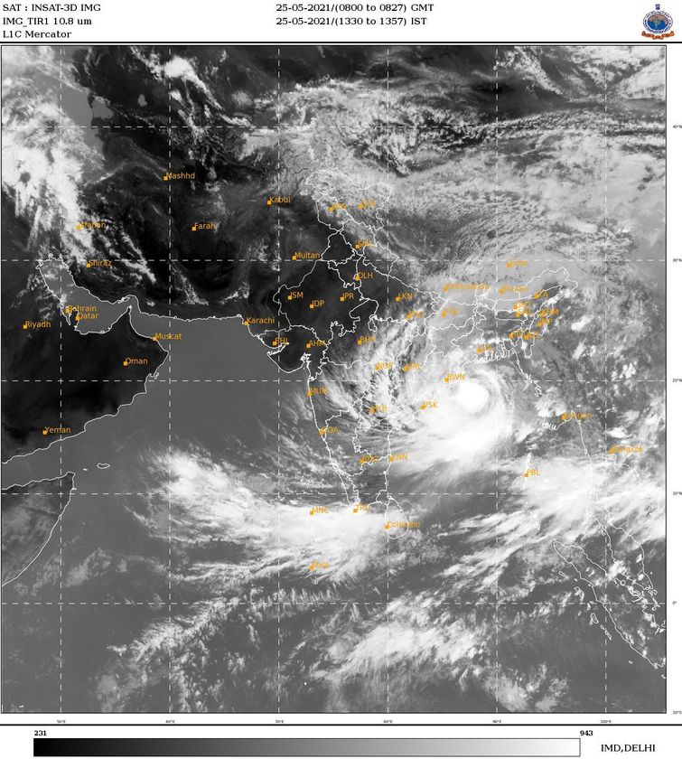
The images showing the latest satellite picture in the figure. 1.
Main Weather Observations (IMD)
Rain/Thundershowers observed (from 0830 hours IST of yesterday to 0830 hours
IST of today): at most places over West Bengal & Sikkim, Andaman & Nicobar
Islands, Nagaland, Manipur, Mizoram & Tripura and Coastal Karnataka; at many
places over Assam & Meghalaya and Lakshadweep; at a few places over
Jharkhand, Odisha, Interior Karnataka and Kerala & Mahe and at isolated places
over Jammu & Kashmir, Ladakh, Gilgit-Baltistan & Muzaffarabad, Himachal
Pradesh, Uttarakhand, Madhya Pradesh, Bihar, Madhya Maharashtra, Konkan &
Goa, Coastal Andhra Pradesh & Yanam, Rayalaseema and Tamil Nadu,
Puducherry & Karaikal.
Heavy Rainfall recorded (from 0830 hours IST of yesterday to 0830 hours IST of
today): Heavy to very heavy rainfall at isolated places over Odisha and heavy
rainfall at isolated places over Gangetic West Bengal, Tripura, South Interior
Karnataka, Kerala & Mahe and Andaman & Nicobar Islands.
Thunderstorm observed (from 0830 hours IST of yesterday to 0830 hours IST
today): at isolated places over Assam & Meghalaya, Tripura, Interior Karnataka,
West Bengal and Odisha. Thundersquall observed at isolated places over
Andaman & Nicobar Islands.
Maximum Temperature Departures as on 24-05-2021: Maximum temperatures
were markedly above normal (5.1°C or more) at most places over Arunachal
Pradesh and Assam & Meghalaya; at a few places over Nagaland, Manipur,
Mizoram & Tripura; at isolated places over Sub-Himalayan West Bengal &
Sikkim; appreciably above normal (3.1°C to 5.0°C) at isolated places over Tamil
2Nadu, Puducherry & Karaikal; above normal (1.6°C to 3.0°C) at a few places over
Saurashtra & Kutch. They were markedly below normal (-5.1°C or less) at a few
places over Rayalaseema and Coastal Andhra Pradesh & Yanam; appreciably
below normal (-3.1°C to -5.0°C) at most places over North Interior Karnataka; at
many places over Haryana, Chandigarh & Delhi, West Uttar Pradesh, East
Madhya Pradesh and Chhattisgarh; at a few places over East Rajasthan and West
Madhya Pradesh; at isolated places over Himachal Pradesh, East Uttar Pradesh,
Madhya Maharshtra and Andaman & Nicobar Islands; below normal (-1.6°C to -
3.0°C) at most places over Jammu & Kashmir, Ladakh, Gilgit-Baltistan &
Muzaffarabad; at many places over West Rajasthan; at a few places over Gangetic
West Bengal; at isolated places over Gujarat Region and Telangana and near
normal over rest parts of the country. Yesterday, the highest maximum
temperature of 42.6°C was reported at Chandrapur (Vidarbha) & Medak
(Telangana) over the plains of the country.
Minimum Temperature Departures as on 25-05-2021: Minimum temperatures are
above normal (1.6°C to 3.0°C) at many places over Assam & Meghalaya; at a few
places over Bihar and Arunachal Pradesh; at isolated places over West Rajasthan,
Saurashtra & Kutch, Coastal Andhra Pradesh & Yanam, Tamil Nadu, Puducherry
& Karaikal and Lakshadweep. They are markedly below normal (-5.1°C or less) at
isolated place over East Madhya Pradesh; appreciably below normal (-3.1°C to -
5.0°C) at many places over Haryana, Chandigarh & Delhi; at isolated places over
Jammu & Kashmir, Ladakh, GilgitBaltistan & Muzaffarabad, Himachal Pradesh,
East Uttar Pradesh, West Madhya Pradesh and Telangana; below normal (-1.6°C
to -3.0°C) at many places over Vidarbha and Odisha; at a few places over West
Uttar Pradesh, East Rajasthan and Rayalaseema and near normal over rest of the
country. Today, the lowest minimum temperature of 20.0°C is reported at
Pantnagar (Uttarakhand) over the plains of the country.
.
Weather Warning during the next 5 days (IMD)
25 May (Day 1): Thunderstorm with lightning & squall (speed reaching 50-60
kmph) very likely at isolated places over Andaman & Nicobar Islands; with
lightning & gusty wind (speed reaching 30-40 kmph) at isolated places over Bihar
and Kerala & Mahe and with lightning at isolated places over East Uttar Pradesh,
Vidarbha, Chhattisgarh, Sub-Himalayan West Bengal & Sikkim, Assam &
Meghalaya, Nagaland, Manipur, Mizoram & Tripura, Konkan & Goa, Madhya
Maharashtra, Telangana, Karnataka, Tamil Nadu, Puducherry & Karaikal and
Lakshadweep. Heavy to Very Heavy Rainfall at a few places with Extremely
3Heavy Falls at isolated places very likely over Odisha; Heavy to Very Heavy
Rainfall at a few places over Gangetic West Bengal and at isolated places over
Assam & Meghalaya and north Coastal Andhra Pradesh & Yanam and Heavy
Rainfall at isolated places over Bihar, Jharkhand, Sub-Himalayan West Bengal &
Sikkim, Andaman & Nicobar Islands, Nagaland, Manipur, Mizoram & Tripura,
Coastal & South Interior Karnataka and Kerala & Mahe. Gale winds speed
reaching 100-110 kmph gusting to 120 kmph is prevailing over major parts of
central Bay of Bengal and adjoining north Bay of Bengal and would increase
gradually becoming 125-135 gusting to 140 kmph from today evening. Squally
wind speed reaching 55-65 kmph gusting 75 kmph is prevailing over North Bay
of Bengal and along and off north Andhra Pradesh-Odisha–West Bengal–
Bangladesh coasts. It would further increase becoming 65-75 kmph gusting to 85
kmph over northwest Bay of Bengal and along & off north Odisha and adjoining
West Bengal coasts from 25th May evening. Squally wind (speed reaching 40-50
kmph gusting to 60 kmph) very likely to prevail over Southwest Arabian Sea.
Strong wind (speed reaching 40-50 kmph) very likely over Gulf of Mannar,
Comorin area and along & off south Tamil Nadu coast. Sea Conditions is high to
very high over Westcentral and adjoining Eastcentral & North Bay of Bengal; very
high to phenomenal over northern parts of Central & North Bay of Bengal and
along & off north Andhra Pradesh-Odisha-West Bengal-Bangladesh coasts.
Fishermen are advised not to venture into these areas. For district updates of
strong surface winds likely to prevail over Odisha, West Bengal, Jharkhand and
Andhra Pradesh, kindly refer to the cyclone bulletins available at:
http://www.rsmcnewdelhi.imd.gov.in
https://mausam.imd.gov.in/imd_latest/contents/cyclone.php#.
26 May (Day 2):Thunderstorm with lightning & squall (speed reaching 50-60
kmph) very likely at isolated places over Andaman & Nicobar Islands; with
lightning & gusty wind (speed reaching 40-50 kmph) at isolated places over Bihar;
with lightning & gusty wind (speed reaching 30-40 kmph) at isolated places over
Chhattisgarh and Sub-Himalayan West Bengal & Sikkim and Kerala & Mahe and
with lightning at isolated places over East Uttar Pradesh, East Madhya Pradesh,
Vidarbha, Arunachal Pradesh, Assam & Meghalaya, Nagaland, Manipur,
Mizoram & Tripura, Coastal & South Interior Karnataka and Lakshadweep.
Heavy to Very Heavy Rainfall at a few places with Extremely Heavy Falls at
isolated places very likely over Odisha; Heavy to Very Heavy Rainfall with
Extremely Heavy Falls at isolated places over Gangetic West Bengal and
Jharkhand; Heavy to Very Heavy Rainfall at isolated places over Assam &
4Meghalaya and Heavy Rainfall at isolated places over Bihar, Sub-Himalayan West
Bengal & Sikkim, Andaman & Nicobar Islands, Arunachal Pradesh and Kerala &
Mahe. Strong surface winds (speed reaching 45-55 kmph) over land areas of
Coastal Andhra Pradesh, Tamil Nadu and Rayalaseema and speed reaching 30-40
kmph over Telangana. Gale wind speed 155-165 kmph gusting to 185 kmph very
likely over northwest Bay of Bengal and along & off north Odisha and adjoining
West Bengal coasts. Squally wind (speed reaching 40-50 kmph gusting to 60
kmph) very likely to prevail over Southwest Arabian Sea. Strong wind (speed
reaching 40- 50 kmph) very likely over Gulf of Mannar, Comorin and along & off
south Tamil Nadu coast. Sea Conditions is high to very high over Westcentral &
adjoining Eastcentral Bay of Bengal. It is very likely to become very high to
phenomenal over northern parts of Central & North Bay of Bengal and along &
off north Andhra Pradesh-Odisha-West Bengal-Bangladesh coasts. Fishermen are
advised not to venture into these areas. For district updates of strong surface
winds likely to prevail over Odisha, West Bengal, Jharkhand and Andhra
Pradesh, kindly refer to the cyclone bulletins available at:
http://www.rsmcnewdelhi.imd.gov.in and
https://mausam.imd.gov.in/imd_latest/contents/cyclone.php#.
27 May (Day 3):Thunderstorm with lightning & squall (speed reaching 50-60
kmph) very likely at isolated places over Andaman & Nicobar Islands; with
lightning & gusty wind (speed reaching 30-40 kmph) at isolated places over East
Uttar Pradesh, Chhattisgarh, Sub-Himalayan West Bengal & Sikkim and Kerala &
Mahe and with lightning at isolated places over Madhya Pradesh, Vidarbha,
Marathwada, Telangana, Coastal Karnataka and Lakshadweep. Heavy to Very
Heavy Rainfall with Extremely Heavy Falls likely at isolated places over Bihar
and Jharkhand and Heavy Rainfall at isolated places over East Uttar Pradesh,
Chhattisgarh, West Bengal & Sikkim, Odisha and Andaman & Nicobar Islands.
Squally wind speed reaching 50-65 kmph gusting to 70 kmph likely over north
Odisha and interior Districts of West Bengal on 27th. Squally wind (speed
reaching 40-50 kmph gusting to 60 kmph) very likely to prevail over Southwest
Arabian Sea. Strong wind (speed reaching 40-50 kmph) very likely over Gulf of
Mannar, Comorin area and along & off south Tamil Nadu coast. Fishermen are
advised not to venture into these areas.
28 May (Day 4):Thunderstorm with lightning & gusty wind (speed reaching 40-50
kmph) likely at isolated places over East Uttar Pradesh and Andaman & Nicobar
Islands; with lightning & gusty wind (speed reaching 30-40 kmph) at isolated
places over Marathwada, Telangana and Kerala & Mahe and with lightning at
5isolated places over Uttarakhand, Madhya Pradesh, Vidarbha, Chhattisgarh,
Bihar, Sub-Himalayan West Bengal & Sikkim, Madhya Maharashtra, Coastal
Andhra Pradesh & Yanam, Karnataka and Lakshadweep. Heavy to Very Heavy
Rainfall at isolated places likely over Bihar and East Uttar Pradesh and Heavy
Rainfall at isolated places over Chhattisgarh, Jharkhand and Andaman & Nicobar
Islands. Squally wind (speed reaching 40-50 kmph gusting to 60 kmph) likely to
prevail over Southwest Arabian Sea. Fishermen are advised not to venture into
these areas.
29 May (Day 5):Thunderstorm with lightning & gusty wind (speed reaching 40-50
kmph) likely at isolated places over East Uttar Pradesh and Andaman & Nicobar
Islands; with lightning & gusty wind (speed reaching 30-40 kmph) at isolated
places over Marathwada, Telangana and Kerala & Mahe and with lightning at
isolated places over Madhya Pradesh, Vidarbha, Chhattisgarh, Madhya
Maharashtra, Coastal Andhra Pradesh & Yanam, Rayalaseema, Karnataka and
Lakshadweep. Heavy to Very Heavy Rainfall likely at isolated places over East
Uttar Pradesh and Bihar and Heavy Rainfall at isolated places over Andaman &
Nicobar Islands, Coastal Karnataka and Kerala & Mahe. Squally wind (speed
reaching 40-50 kmph gusting to 60 kmph) likely to prevail over Southwest
Arabian Sea. Fishermen are advised not to venture into these areas.
The weather outlook for seven days i.e., 25 May to 02 Jun 2021 forecasted
(Provided by Real-Time Weather Forecasts from NOAA/NCEP collected from
http://monsoondata.org/wx2/) rain/thundershower may occur over Some
parts of Extreme northern parts of India. (Fig. 2).
Agricultural activities (AICRPAM-CRIDA)
Assam
Weather condition:
Weather during the last week was mainly cloudy. Daily average maximum temperature
was 30. 2°C which was 0.1°C below normal and the average daily minimum temperature
was 20.8°C which was 0.3°C below normal for the week. Total BSSH was 4.2hrs with an
average of 0.6hrs/day. The daily average evaporation rate was 1.6mm/day and the
average daily wind speed during the week was 2.4kmph. Daily average RH during
morning and afternoon hour was 83.5% and 74.7% respectively.
Contingency measure:
Sali rice (Nursery preparation):- Taking advantage of pre-monsoon rainfall
received during the past week and also the anticipated rainfall amount in the
coming 5 days, farmers can start nursery bed preparation for sowing of Sali rice
6seeds. The nursery beds should be of 10m long and 1.25m wide prepared in
levelled well-puddled soil and the distance between the beds should be about 30
cm. About 6-7 such beds will be required to transplant one bigha of land and a
recommended quantity of 650g to 1 kg of seeds should be sown in each bed. Prior
to sowing, 20Kg FYM, 80gm Urea, 80gm SSP and 40gm MOP should be
thoroughly incorporated in each of the beds. Collect seeds of recommended Sali
rice varieties viz., Ranjit, Ranjit Sub 1, Bahadur, Satyaranjan, Basundhara,
Mahsuri, Ketekijoha etc. for obtaining higher yield. Select varieties like
Satyaranjan and Basundhara, having crop duration of 130-135 days, in double
cropping areas. Select water submergent tolerant rice varieties such as Jalashree,
Jalkunwari, Ranjit Sub-1, Swarna Sub-1, etc. in chronically flood affected areas.
Citrus (Planting):- May to August month is the suitable time for planting of
cuttings of citrus in main field. Farmers are suggested to make provisions for
transplanting of citrus cuttings (stem/leaf-bud/air layering) in the main field
before onset of monsoon by making pits of size 0.5m x 0.5m dug at a spacing of
3m × 3m. Prior to transplanting refill the pits with soil-manure mixture (1:1) and
allow it to settle for few days.
Vegetable orchard (various):- Make provisions for small drains at required
interval in the orchards to drain out excess water. Harvest the matured
vegetables and fruits as early as possible. Provide mechanical support to the
crops like banana, citrus, papaya etc. to protect them from lodging. Proper
sanitation will reduce the infestation of borers and suckers in the vegetable
orchards. Destroy the infested fruits whenever came into notice. Burning of dried
leaves mixed with dried chilli near the infested orchards will control the pest up
to certain extent. Withhold spraying of pesticides during cloudy weather.
Summer pulses (Physiological maturity):- Mainly green and black gram crops are
in podding to maturity stage. The matured crops may be harvested when pods
are full darkish colour and brittle on slight pressure. Harvesting should be
completed in 2-3 pickings.
Colocasia (Planting):- April to June is the best planting time for Assam for
colocasia as the crop receives sufficient rainfall due to monsoon shower. The best
soil is sandy loam or alluvial with abundant organic matter. The land should be
ploughed 2-3 times after applying adequate amount of organic manure and
wood ash. Small corms or setts cut from large corms may be selected as a
planting material.
Fodder crops (Planting):- Farmers engaged in dairy farming or farmers having
livestock as an agricultural component are advised to make provisions for
7planting the rooted slips of fodder crops like Napier, Guinea, Setaria, Para etc. at
a spacing of 45 cm. These crops can also be raised as intercrop in the arecanut
and coconut orchards.
Livestock (Various):- To protect the goats and sheep from Contagious Ecthyma
disease, immunize them at 6-8 weeks of age with vaccines after proper
consultation with a veterinary doctor.
.
8Figure: 1. Latest available satellite picture as on 25 May 2021 at 1357 Hrs (IST). (Source:
IMD).
9Figure:2. Precipitation forecast for 25 May to 02 Jun 2021 (Source: NOAA NCEP).
Disclaimer: The predictability of weather depends on many dynamic factors. The success of Agromet advisories provided here
depends on the accuracy of the forecasts. In no event will India Meteorological Department (IMD) and Indian
Council of Agricultural Research (ICAR) be liable to the user or any third party for any direct, indirect, incidental,
consequential, special or exemplary damages or lost profit resulting from any use or misuse of the information on this bulletin.
10You can also read