All India Coordinated Research Project on Agrometeorology - ICAR
←
→
Page content transcription
If your browser does not render page correctly, please read the page content below
All India Coordinated Research Project on Agrometeorology
CRIDA, Santoshnagar, Hyderabad – 500 059
Daily Crop Weather Information as on 13 May 2021
Attention: Rajiv Maheshwari, OSD, ICAR
Significant Weather Features (IMD)
A cyclonic circulation lies over Southeast Arabian Sea extending upto mid
tropospheric level. Under its influence, a Low Pressure Area is very likely to form
over the same region during next 24 hours. It is very likely to concentrate into a
Depression over Lakshadweep area and adjoining Southeast & Eastcentral
Arabian Sea by 15th May. It is very likely to move north-northwestwards and
intensify further into a Cyclonic Storm over Eastcentral Arabian Sea around 16th
May and continue to move north-northwestwards for some more time with
further intensification. Under its influence, heavy to very heavy rainfall is likely at
a few places during 14-16 May with isolated extremely heavy falls over
Lakshadweep on 14 and 15 May; heavy to very heavy rainfall is likely at a few
places over Kerala and over isolated places over Tamilnadu and coastal and south
Interior Karnataka during 14-16 May. Fishermen are advised not to venture out to
the southeast Arabian Sea and adjoining Maldives, Comorin and Lakshadweep
area, Kerala coast from morning of 13 May and east central Arabian sea and along
and off Karnataka-Goa and Maharashtra and Goa coasts from 14th Night. Those,
who are in Sea are advised to return to the coast by the night of 12th May, 2021.
A Western Disturbance as a trough runs along Longitude 70ºE and north of
Latitude 28ºN in middle tropospheric levels. A cyclonic circulation lies over
Punjab & neighbourhood and an east-west trough runs from this cyclonic
circulation to Sub-Himalayan West Bengal & Sikkim at lower levels. In addition,
there is likely confluence of winds from Arabian Sea and easterly winds at lower
levels over northwest India during next 2 days. Under the influence of these
systems, fairly widespread to widespread rainfall with isolated
thunderstorm/lightening/gusty winds & hailstorm very likely over Western
Himalayan Region and scattered to fairly widespread rainfall with isolated
thunderstorm/lightening/gusty winds over plains of northwest India during
next 24 hours and decrease significantly thereafter. Isolated heavy rainfall is also
likely over Uttarakhand, Punjab and Haryana & Chandigarh on 13 May, 2021.
1 Under the influence of above mentioned east-west trough at lower levels and
north-south trough over northeast India at middle tropospheric levels, fairly
widespread to widespread rainfall/thunderstorm activity is very likely to
continue over northeastern states and West Bengal & Sikkim and isolated to
scattered rain/thundershower over rest parts of east India during next 2 days and
decrease in intensity & distribution thereafter. Isolated heavy rainfall is also likely
over Arunachal Pradesh, Assam & Meghalaya, Nagaland, Manipur, Mizoram &
Tripura and Sub Himalayan West Bengal on 13 May.
No heat wave is likely over any part of the country during next 5 days.
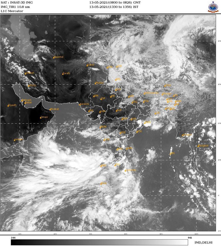
The images showing the latest satellite picture in the figure. 1.
Main Weather Observations (IMD)
Rain/Thundershowers observed (from 0830 hours IST to 1730 hours IST of
yesterday): at most places over Sub-Himalayan West Bengal & Sikkim, Bihar,
Uttarakhand and Lakshadweep.; at many places over Jammu, Kashmir, Ladakh,
Gilgit-Baltistan & Muzaffarabad, Himachal Pradesh and Jharkhand; at a few
places over Arunachal Pradesh and Assam & Meghalaya and at isolated places
over Nagaland, Manipur, Mizoram & Tripura, East Uttar Pradesh, Madhya
Pradesh, Rajasthan, Tamilnadu, Puducherry & Karaikal, Coastal Karnataka and
Kerala.
Heavy Rainfall observed (from 0830 hours IST to 1730 hours IST of yesterday):
Heavy to Very Heavy Rainfall at isolated places over Lakshadweep and heavy
rainfall at isolated places over Himachal Pradesh.
Thunderstorm observed (from 2030 hours IST of yesterday to 0530 hours IST of
today): at a few places over East Uttar Pradesh, Jammu, Kashmir, Ladakh, Gilgit-
Baltistan & Muzaffarabad and West Rajasthan; at isolated places over Punjab,
Haryana, Chandigarh & Delhi, East Rajasthan, Chhattisgarh, Gangetic West
Bengal, Odisha, Assam & Meghalaya, Jharkhand, Telangana, Coastal & South
Interior Karnataka and Kerala & Mahe.
Maximum Temperature Departures as on 12-05-2021: Maximum temperatures
were markedly above normal (5.1°C or more) at most places over Andaman &
Nicobar Islands; at many places over Konkan & Goa; at a few places over
Saurashtra & Kutch and Coastal Karnataka. They were markedly below normal (-
5.1°C or more) at many places over Bihar; at a few places over Sub-Himalayan
West Bengal & Sikkim; at isolated places over East Uttar Pradesh and Punjab;
appreciably below normal (-3.1°C to -5.0°C) at most places over Haryana,
Chandigarh & Delhi, Himachal Pradesh and Chhattisgarh; at many places over
2Arunachal Pradesh, Nagaland, Manipur, Mizoram & Tripura and Lakshadweep;
at a few places over Gangetic West Bengal, Odisha and Uttarakhand; at isolated
places over West Uttar Pradesh, West Rajasthan, Coastal Andhra Pradesh &
Yanam and Rayalaseema; below normal (-1.6°C to -3.0°C) at most places over
Madhya Pradesh and Jharkhand; at many places over interior Karnataka; at
isolated places over Gujarat Region and Tamilnadu, Puducherry & Karaikal and
near normal over rest parts of the country. Yesterday, the highest Maximum
Temperature of 43.2 °C was reported at Chandrapur (Vidarbha).
Minimum Temperature Departures as on 12-05-2021: Minimum temperatures
were above normal (1.6°C to 3.0°C) at a few places over Tamil Nadu, Puducherry
& Karaikal; at isolated places Jammu, Kashmir, Ladakh, Gilgit-Baltistan and
Muzaffarabad, Himachal Pradesh, West Rajasthan, Gujarat Region, East Uttar
Pradesh and Andaman & Nicobar Islands. They were markedly below normal (-
5.0°C or less) at isolated places over Coastal Andhra Pradesh & Yanam;
appreciably below normal (-3.1°C to -5.0°C) at many places over Odisha and
Telangana; at a few places over Gangetic West Bengal, Chhattisgarh and
Rayalaseema; at isolated places over Bihar; below normal (-1.6°C to -3.0°C) at
many places over East Madhya Pradesh; at a few places over West Madhya
Pradesh and Lakshadweep; at isolated places over Haryana, Chandigarh & Delhi,
East Rajasthan, Vidarbha and Sub-Himalayan West Bengal & Sikkim and near
normal over rest parts of the country. Yesterday, the lowest minimum
temperature of 18.0°C was reported at Bahraich (East Uttar Pradesh) over the
plains of the country.
Weather Warning during the next 5 days (IMD)
13 May (Day 1): Thunderstorm with lightning, hail & squall (speed reaching 50-60
kmph) very likely at isolated places over Punjab and Haryana, Chandigarh &
Delhi; with lightning, hail & gusty winds (speed reaching 30-40 kmph) at isolated
places over Himachal Pradesh, Uttarakhand and Telangana; with lightning &
gusty wind (speed reaching 40-50 kmph) at isolated places over Gangetic West
Bengal; with lightning & gusty wind (speed reaching 30-40 kmph) at isolated
places over Uttar Pradesh, Bihar, Jharkhand, Sub-Himalayan West Bengal &
Sikkim, Odisha, Kerala & Mahe and Lakshadweep; with lightning at isolated
places over Jammu & Kashmir, Ladakh, Gilgit-Baltistan & Muzaffarabad,
Chhattisgarh, Arunachal Pradesh, Assam & Meghalaya, Nagaland, Manipur,
Mizoram & Tripura, Coastal Andhra Pradesh & Yanam, Rayalaseema, Karnataka
and Tamil Nadu, Puducherry & Karaikal. Thunderstorm/Duststorm/Hailstorm
(speed reaching 40-50 kmph) very likely at isolated places over north Rajasthan.
3Heavy rainfall very likely at isolated places over Uttarakhand, Punjab, Haryana,
Chandigarh & Delhi, West Bengal & Sikkim, Odisha, Arunachal Pradesh, Assam
& Meghalaya, Nagaland, Manipur, Mizoram & Tripura, Coastal & South Interior
Karnataka, Tamil Nadu, Puducherry & Karaikal, Kerala & Mahe and
Lakshadweep. Squally wind speed reaching 40-50kmph gusting to 60kmph very
likely over Southeast Arabian Sea and adjoining equatorial India Ocean,
Maldives, Comorin and Lakshadweep area and along and off Kerala coast.
Squally Weather (wind speed reaching 40-50 kmph) very likely over Southwest
and adjoining equatorial India Ocean. Fishermen are advised not to venture into
these areas.
14 May (Day 2): Thunderstorm with lightning & gusty wind (speed reaching 30-
40 kmph) very likely at isolated places over Punjab, Haryana, Chandigarh &
Delhi, Rajasthan, Gangetic West Bengal, Madhya Maharashtra, Marathwada,
Telangana, Tamil Nadu, Puducherry & karaikal, Kerala & Mahe and
Lakshadweep; with lightning at isolated places over Jammu & Kashmir, Ladakh,
Gilgit-Baltistan & Muzaffarabad, Himachal Pradesh, Uttarakhand, Uttar Pradesh,
Chhattisgarh, Sub-Himalayan West Bengal & Sikkim, Odisha, Assam &
Meghalaya, Nagaland, Manipur, Mizoram & Tripura, Gujarat state, Konkan &
Goa, Coastal Andhra Pradesh & Yanam, Rayalaseema and Karnataka. Heavy to
very heavy rainfall with extremely heavy falls very likely at isolated places
Lakshadweep; heavy to very heavy rainfall at a few places over Kerala & Mahe
and at isolated places over Coastal & South Interior Karnataka and Tamil Nadu,
Puducherry & Karaikal and Heavy Rainfall at isolated places over Sub-Himalayan
West Bengal & Sikkim and Assam & Meghalaya. Squally wind speed reaching
45kmph gusting to 55kmph over Southeast Arabian Sea and adjoining equatorial
India Ocean, Maldives, Comorin and Lakshadweep area and along and off Kerala
coast. Squally Weather (wind speed reaching 40-50 kmph) also very likely over
Southwest and adjoining equatorial India Ocean. Sea conditions over southeast
Arabian Sea and adjoining Lakshadweep-Maldives area & equatorial Indian
Ocean will be rough to very rough. Sea conditions will be rough to very rough
over Comorin area and along & off Kerala coast. Fishermen are advised not to
venture into these areas.
15 May (Day 3): Thunderstorm with lightning & gusty wind (speed reaching 30-
40 kmph) likely at isolated places over Madhya Maharashtra, Marathwada,
Rayalaseema, Karnataka, Tamil Nadu, Puducherry & Karaikal, Kerala & Mahe
and Lakshadweep; with lightning at isolated places over Chhattisgarh, Gangetic
West Bengal, Gujarat state, Konkan & Goa, Coastal Andhra Pradesh & Yanam
4and Telangana. Heavy to very heavy rainfall with extremely heavy falls likely at
isolated places Lakshadweep; heavy to very heavy rainfall at a few places over
Coastal & South Interior Karnataka and Kerala & Mahe and at isolated places
over Tamil Nadu, Puducherry & Karaikal and Heavy Rainfall at isolated places
over Konkan & Goa, Rayalaseema and North Interior Karnataka. Squally wind
speed reaching 50-60 kmph gusting to 70kmph likely over southeast Arabian Sea
and adjoining east central Arabian Sea, and along and off Kerala-Karnataka coast ,
Lakshadweep, Maldives areas and adjoining equatorial Indian Ocean till
afternoon of 15th May. It is likely to increase with Gale wind speed 60-70 kmph
gusting to 80kmph over East central Arabian Sea and adjoining southeast Arabian
Sea and Lakshadweep area from night of 15th May. Squally wind speed reaching
40-50 kmph gusting to 60kmph also very likely along and off Maharashtra coast.
Squally Weather (wind speed reaching 40-50 kmph) very likely over Southwest
and and adjoining equatorial India Ocean. Sea conditions over southeast Arabian
Sea and adjoining LakshadweepMaldives area & equatorial Indian Ocean will be
rough to very rough. Sea conditions will be rough to very rough over eastcentral
Arabian Sea along & off Karnataka coast. Tidal wave of about 1meter height
above the astronomical tide is very likely to inundate low lying areas of
Lakshadweep Islands. Fishermen are advised not to venture into these areas.
16 May (Day 4): Thunderstorm with lightning & gusty winds (speed reaching 30-
40 kmph) likely at isolated places over Telangana, Karnataka, Tamil Nadu,
Puducherry & Karaikal, Kerala & Mahe and Lakshadweep; with lightning at
isolated places over Vidarbha, Chhattisgarh, Gujarat state, Konkan & Goa,
Madhya Maharashtra, Marathwada and Coastal Andhra Pradesh & Yanam and
Rayalaseema. Heavy to very heavy rainfall likely at a few places over Coastal &
South Interior Karnataka and at isolated places over Tamil Nadu, Puducherry &
Karaikal, Kerala & Mahe and Lakshadweep and Heavy Rainfall at isolated places
over Konkan & Goa, North Interior Karnataka and Telangana. Gale wind speed
reaching 70-80 kmph gusting to 90 kmph likely over eastcentral Arabian Sea and
Gale wind speed 60-70 kmph gusting to 80kmph likely over southeast Arabian
Sea and along and off Kerala-Karnataka coast , Lakshadweep, Maldives areas and
adjoining equatorial Indian Ocean. Squally wind speed reaching 40-50 kmph
gusting to 60kmph also very likely along and off Maharashtra coast . Squally
Weather (wind speed reaching 40-50 kmph) very likely over Southwest and and
adjoining equatorial India Ocean. Sea conditions will be very rough to
Phenomenal over eastcentral Arabian Sea and rough to very rough along & off
Goa, Karnataka, Kerala coast, southeast Arabian Sea and adjoining Lakshadweep-
5Maldives area & equatorial Indian Ocean. Tidal wave of about 1metre height
above the astronomical tide is very likely to inundate low lying areas of
Lakshadweep Islands. Fishermen are advised not to venture into these areas.
17 May (Day 5): Thunderstorm with lightning & gusty winds (speed reaching 30-
40 kmph) likely at isolated places over Konkan & Goa, Madhya Maharashtra,
Marathwada, Telangana, Karnataka, Tamil Nadu, Puducherry & Karaikal, Kerala
& Mahe and Lakshadweep; with lightning at isolated places over Vidarbha,
Chhattisgarh, Gujarat state and Coastal Andhra Pradesh & Yanam and
Rayalaseema. Heavy to very heavy rainfall likely at a few places over Coastal &
South Interior Karnataka and Konkan & Goa and at isolated places over Tamil
Nadu, Puducherry & Karaikal, Kerala & Mahe and Lakshadweep and Heavy
Rainfall at isolated places over North Interior Karnataka and Madhya
Maharashtra. Gale wind speed reaching 70-80 kmph gusting to 90 kmph likely
over eastcentral Arabian Sea and Gale wind speed 60-70 kmph gusting to 80kmph
likely over southeast Arabian Sea and along and off Kerala-Karnataka coast ,
Lakshadweep, Maldives areas and adjoining equatorial Indian Ocean. Squally
wind speed reaching 40-50 kmph gusting to 60kmph also very likely along and
off Maharashtra coast . Squally Weather (wind speed reaching 40-50 kmph) very
likely over Southwest and and adjoining equatorial India Ocean. Sea conditions
will be very rough to Phenomenal over eastcentral Arabian Sea and rough to very
rough along & off Goa, Karnataka, Kerala coast, southeast Arabian Sea and
adjoining Lakshadweep-Maldives area & equatorial Indian Ocean. Tidal wave of
about 1metre height above the astronomical tide is very likely to inundate low
lying areas of Lakshadweep Islands. Fishermen are advised not to venture into
these areas.
The weather outlook for seven days i.e., 13 May to 21 May 2021 forecasted
(Provided by Real-Time Weather Forecasts from NOAA/NCEP collected from
http://monsoondata.org/wx2/) rain/thundershower may occur over Some
parts of Extreme northern parts of India. (Fig. 2).
Agricultural activities (AICRPAM-CRIDA)
Konkan region
Weather condition:
Atmospheric condition was cloudy during morning hours around Dapoli during last
week. Therefore 6.5 to 10.1 Bright sunshine hours was recorded during last week.
During last week 0.0 mm rainfall was recorded at Agrometeorological observatory, Dr.
B.S.K.K.V. Dapoli. The maximum and minimum temperature ranged from 33.0 to 35.2
6and 16.6 to 22.8 oC respectively. Wind velocity ranged from 4.2 to 5.3 km and wind was
blowing from south westerly Direction.
Contingency measure:
General advisory:Due to forecast of thunderstorm along with lighting and rain
and gusty winds at isolated places over district from 14th to 15th May, 2021, keep
farm animals at safe place and away from open water, pond or river. Also
harvest and stored the matured pulse crop at protective and safe place. Provide
staking to newly planted fruit crops orchard.
SMS:In view of likely Cyclonic storm formation over south Arabian Sea around
15 May 2021. Fishermen are advised not to venture out to the southeast Arabian
Sea. Those, who are in Sea are advised to return to coast by night of 12th May,
2021.
Mango:There is forecast for light rainfall and increase in wind speed from 14th to
16th May 2021, harvest the matured mango fruits at 80 to 85% maturity in the
morning or evening hours during clear weather (no rainfall) and keep the
harvested fruits in shade to prevent spongy tissue disease and from heat.To
prevent incidence of post-harvest diseases fruit rot on fruits, place the fruits in
hot water of 52oC for 10 minutes and then keep for ripening. Use C.F.B.
(corrugated fiber box) for packing. Transport of harvested fruits should be done
preferably during night hours.There is possibility for incidence of fruit fly on
mango fruits. Collect and destroy all.There is forecast for rise in temperature and
wind speed, provide irrigation to newly planted mango grafts as per requirement
also provide staking with bamboo sticks.
Cashewnut:There is forecast for rise in temperature and wind speed, provide
irrigation to newly planted cashewnut grafts as per requirement also provide
staking with bamboo sticks.
Coconut:There is forecast for rise in temperature and wind speed, provide
irrigation to newly planted coconut plant as per requirement also provide staking
with bamboo sticks.
Arecanut:There is forecast for rise in temperature and wind speed, provide
irrigation to newly planted arecanut plant as per requirement also provide
staking with bamboo sticks.Clean the arecanut orchard by removing dry leaves
and diseased, infected inflorescence and spray 1% bordomixture to control
?Koleroga? disease. Repeat the spray 3-4 times at one-month interval.
Kharif rice:In kharland area for rice cultivation, turn the clods with the help of
crowbar before rain and prepare drainage channel of 30 cm depth and 45 cm
wide around rice field to help drain out the salts from field.For preparation of
7rice nursery, plough the area add FYM@100 kg per guntha area and bring the soil
to fine tilth. Prepare raised bed of 120 cm. breadth at bottom and 90 cm. on top
along the slope of land. Convenient length of raised bed should be kept
according to the land slope.
Groundnut:There is forecast for light rainfall from 14th to 16th May 2021,
carryout harvesting of matured pods by uprooting the plant when there is
enough moisture in the soil during clear weather (no rainfall). Strip off the pods
from the plant and keep for drying at safe and protective place.
Turmeric:For cultivation of turmeric, carryout ploughing operation and
incorporate 250-400 kg/guntha FYM or compost at the time of ploughing. For
planting either use ridge and furrow of 75 cm or broadbed furrow of size 90 cm
to 1 meter by maintaining 30 cm distance between two plants. Apply 3.75 kg SSP
and 1 kg MOP per guntha at the time of planting and 2.5 kg urea in three equal
splits at one, three and four months after planting. Use healthy, sprouted,
rootless rhizomes for planting. Before planting, treat the rhizomes by dipping 15-
20 minutes in solution of quinalphos 25%EC @ 20 ml + Bavistin @ 20 gms in 10
liters of water and dry in shed. Seed rate require is 25 kg per guntha. Plant
rhizomes either at field capacity or in impound water.
Vegetable crops:If irrigation facility is available then go for sowing nursery of
brinjal, chilli and tomato vegetables crops for kharif season. Prepare raised bed of
3 m length x 1 m breadth x 15 cm height. mix well decomposed FYM @500 gms
per guntha in to soil at the time of bed preparation. Prepare raised bed of 3 m
length x 1 m breadth x 15 cm height. At the time of sowing apply 35 gm urea, 100
gm single super phosphate and 25 gm muriate of potash per sq. m. Before
sowing, treat the seed with thiram fungicide @ 3 gm/kg of seed or Trichoderma
@ 5 gm/kg for protection from seed borne diseases. for seed treatment of
Trichoderma use water to prepare paste to adhere like seed coat.Use wilt
resistance varieties and follow crop rotation with other than solanaceous crop for
management of wilt disease.
8Figure: 1. Latest available satellite picture as on 13 May 2021 at 1356 Hrs (IST). (Source:
IMD).
9Figure:2. Precipitation forecast for 13 May to 21 May 2021 (Source: NOAA NCEP).
Disclaimer: The predictability of weather depends on many dynamic factors. The success of Agromet advisories provided here
depends on the accuracy of the forecasts. In no event will India Meteorological Department (IMD) and Indian
Council of Agricultural Research (ICAR) be liable to the user or any third party for any direct, indirect, incidental,
consequential, special or exemplary damages or lost profit resulting from any use or misuse of the information on this bulletin.
10You can also read