Subject: Current Weather Status and Outlook for next two weeks (17-30 June 2021) - IMD
←
→
Page content transcription
If your browser does not render page correctly, please read the page content below
Government of India
                          Earth System Science Organization
                              Ministry of Earth Sciences
                           India Meteorological Department

                                                                          Dated: 17 June, 2021

Subject: Current Weather Status and Outlook for next two weeks
(17-30 June 2021)

a. Significant weather features observed for week ending on 16 May 2021

❖   Advance of Southwest Monsoon

➢ Southwest Monsoon has further advanced into some more parts of south Gujarat region,
  remaining parts of Maharashtra, Telangana and Coastal Andhra Pradesh, some parts of south
  Madhya Pradesh, Chhattisgarh and south Odisha, remaining parts of Central Bay of Bengal and
  most parts of North Bay of Bengal on 10th June, 2021; it has further advanced into some parts of
  North Arabian Sea, some more parts of south Gujarat Region, south Madhya Pradesh and
  Chattisgarh and most parts of North Bay of Bengal and some more parts of West Bengal on 11th
  June 2021; it has further advanced into remaining parts of Northwest Bay of Bengal, some more
  parts of Odisha, most parts of West Bengal and some parts of Jharkhand and Bihar on 12th; it has
  further advanced into some more parts of Madhya Pradesh, entire Chhattisgarh, Odisha, West
  Bengal,Jharkhand and Bihar, most parts of East Uttar Pradesh, some parts of West Uttar
  Pradesh; entire Uttarakhand, Himachal Pradesh and Jammu & Kashmir, Ladakh, Gilgit-Baltistan
  & Muzaffarabad and some parts of north Haryana, Chandigarh and north Punjab on 13th June,
  2021;no further advance of Southwest Monsoon has taken place during the remaining part of the
  week , since the conditions were not favourable for the same.
➢ The Northern Limit of Monsoon (NLM) passed through lat. 20°N/ Long. 60°E, lat. 20.5°N/ Long.
  70°E, Surat, Nandurbar , Betul,Mandla, Bilaspur, Bolangir, Puri, 22.5°N/89.5°E, 24°N/89.5°E and
  Baghdogra on 10th June 2021; it passed through lat. 20.5°N/ Long. 60°E, Diu, Surat, Nandurbar
  , Raisen, Damoh, Umaria,Pendra Road, Bolangir, Puri, 21°N/88°E, Canning, Krishnanagar,
  Malda and 26.5°N/88°E on 11th; it passed through lat. 20.5°N/ Long. 60°E, Diu, Surat, Nandurbar
  , Raisen, Damoh, Umaria,Pendra Road, Bolangir, Bhubaneswar, Baripada, Purulia, Dhanbad,
  Dharbhanga and Lat. 27°N/85°E on 12th; it passed through lat. 20.5°N/ Long. 60°E, Diu, Surat,
  Nandurbar, Bhopal, Nowgong,Hamirpur, Barabanki, Bareilly, Saharanpur, Ambala and Amritsar
  on 13th and remained the same till the end of the week. (Fig.1)

                                                                                       1|Page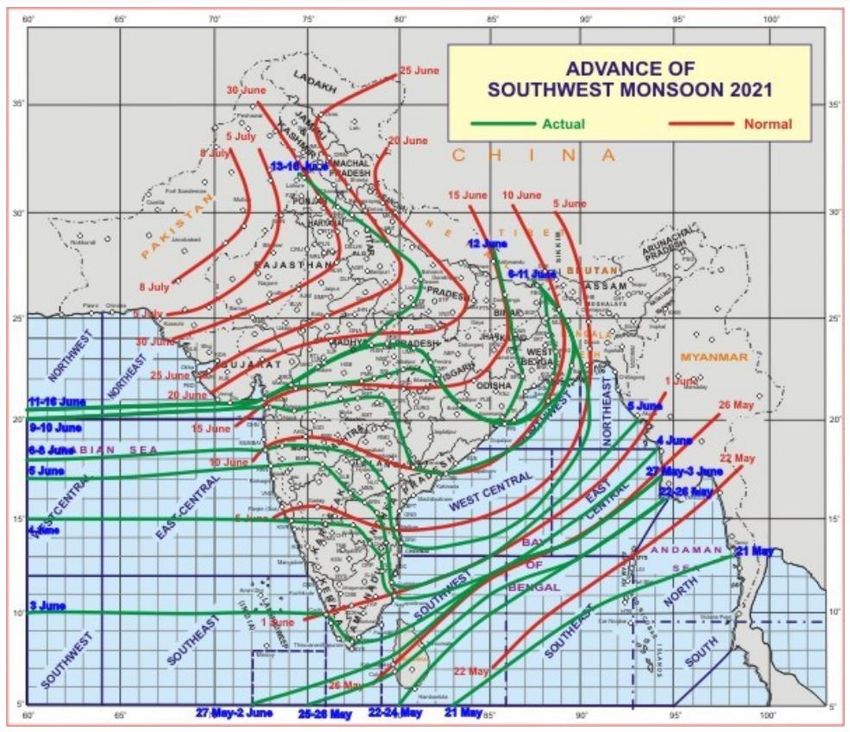
Fig.1

 ❖ Major Weather Systems
➢ A Low Pressure Area has formed over Northwest Bay of Bengal & adjoining Odisha and Gangetic
   West Bengal coasts in the early morning hours of 11th June 2021 and it persisted over the same
   area on that day; it lay over Northwest Bay of Bengal and adjoining coastal areas of West Bengal
   and North Odisha on 12th and 13th ; it lay over south Jharkhand & neighbourhood on 14th and over
   East Uttar Pradesh and adjoining Bihar on 15th; the Low Pressure Area has become less marked
   however, its associated cyclonic circulation lay over East Uttar Pradesh & neighbourhood and
   extended upto 3.1 km above mean sea level on 16th June 2021; Under the influence of this Low
   pressure area and its associated cyclonic circulation extending upto mid tropospheric levels and
   tilting southwestward with height, fairly widespread to widespread rainfall/thunderstorms had
   occurred over East India and adjoining areas of Central India during the week; isolated heavy to
   very heavy and extremely heavy rainfall also had been reported over parts of Bihar, Gangetic
   West Bengal and East Uttar Pradesh whereas isolated heavy to very heavy rainfall had been
   reported over Sub Himalayan West Bengal & Sikkim and Odisha on one or two days along with;

                                                                                        2|Page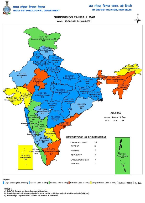
this system has also caused isolated heavy rainfall over Jharkhand throughout the week and over
  Odisha, Chhattisgarh and East Uttar Pradesh on four to five days during the week.
➢ Formation of the above mentioned Low pressure area has caused strengthening of the westerlies
  along the west coast; this along with an off shore trough which lay extending from Maharashtra
  coast to Kerala coast and persisted almost throughout the week had caused widespread
  rainfall/thunderstorms along the west coast throughout the week along with isolated heavy to very
  heavy and extremely heavy rainfall on a few days; interior parts of peninsular India and adjoining
  areas of Maharashtra have also reported fairly widespread to widespread rainfall/thunderstorms
  on a few days along with isolated heavy rainfall on two to three days during the week.
➢ Movement of Western Disturbance and cyclonic circulations in the lower tropospheric levels
  supported by moisture incursion into the area has caused fairly widespread to widespread
  rainfall/thunderstorms over Western Himalayan Region and scattered to fairly widespread
  rainfall/thunderstorms over adjoining areas of Northwest India during the week; it has caused
  isolated heavy/very heavy rainfall over Uttarakhand on a few days and isolated heavy rainfall over
  remaining parts of Western Himalayan Region and adjoining plains on one or two days during the
  week.

Heavy Rain:

 ♦ Heavy to Very heavy rainfall with extremely heavy falls at isolated places had occurred over
   Konkan & Goa on three days; over East Uttar Pradesh on two days and over Gangetic West
   Bengal & Bihar on one day each during the week.

 ♦ Heavy to Very heavy rainfall at isolated places had occurred over Konkan & Goa, Telengana and
   Coastal Karnataka on three days each; over Bihar, Chhattisgarh and South interior Karnataka on
   two days each; over Andaman & Nicobar Islands, Assam & Meghalaya, Sub Himalayan West
   Bengal & Sikkim, Odisha, East & West Uttar Pradesh, Uttarakhand, Madhya Maharashtra, Tamil
   Nadu, Puducherry & Karaikkal and Kerala & Mahe on one day each during the week.

 ♦ Heavy rainfall at isolated places had occurred at isolated places over Jharkhand on seven
   days;over Assam & Meghalaya and Chattisgarh on five days each;over Odisha, East Uttar
   Pradesh, East &West Madhaya Pradesh and Vidarbha on four days each;over Nagaland,
   Manipur, Mizoram & Tripura, Uttarakhand, Himachal Pradesh,Marathwada, Coastal & North
   Interior Karnataka and Kerala & Mahe on three days each;over Bihar, West Uttar Pradesh,
   Madhya Maharashtra, Telengana, Tamil Nadu, Puducherry & Karaikkal and South Interior
   Karnataka on two days each; over Arunachal Pradesh, Sub Himalayan West Bengal & Sikkim,
   Haryana, Chandigarh & Delhi, Punjab, Jammu Kashmir & Ladakh, Gujarat Region, Konkan & Goa
   and Coastal Andhra Pradesh & Yanam on one day each during the week.

Hail Storm / Dust Storm:

♦ Hail Storm had been reported at isolated places over Jammu Division of Jammu Kashmir & Ladakh
  and over Uttarakhand on one day each during the week.

♦ Dust Storm had been reported at isolated places over West Rajasthan on one day during the week.

Temperature Scenario:

                                                                                         3|Page
♦ No heat wave spell was reported from any areas of the country during the week due to rain and
thunderstorm activities over many parts of India during many days of the week. The highest
maximum temperature of 45.3oC had been recorded at Ganganagar (West Rajasthan) on 10th
June 2021 and the lowest minimum temperature of 16.6oC had been recorded at Bidar (North
Interior Karnataka) on 14th June 2021 over the plains of the country during the week.
LEGEND: A few days- 3 days, Many days- 4 to 5 days and Most days- 6 to 7 days during the week.
b. Weekly rainfall and seasonal rainfall Scenario
•
Weekly Rainfall Scenario (10-16 June, 2021)
During the week, rainfall for the country as a whole was above Long Period Average
(LPA) by 43%. Details are given in Table 1
The Meteorological sub-division-wise rainfall for the week is given in Annexure I.
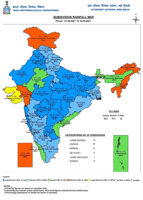
Southwest Monsoon season’s Rainfall Scenario (1 June to 16 June, 2021)
For the country as a whole, cumulative rainfall during this year’s Southwest
Monsoon season’s Rainfall till 16 June, 2021 is excess with +33 % departure from
LPA. Details of the rainfall distribution over the four broad geographical regions of India are
given Table 1
Table 1: Rainfall status (Week and season)
WEEK SEASON
10.06.2021 TO 01.06.2021 TO
Region
16.06.2021 16.06.2021
Actual Normal % Departure Actual Normal % Departure
EAST & NORTH-EAST
INDIA 84.0 80.4 4% 166.3 161.8 +3%
NORTH-WEST INDIA 30.9 15.0 106% 45.0 27.5 +64%
CENTRAL INDIA 48.3 40.7 19% 104.2 80.0 +30%
SOUTH PENINSULA 48.3 40.7 19% 104.2 80.0 +30%
country as a whole 54.0 37.8 43% 93.4 70.2 +33%
4|Page
c. Chief synoptic conditions as on 17 June, 2021
     ♦ A cyclonic circulation lies over East Uttar Pradesh & neighbourhood extending upto 3.1 km
     above mean sea level.
     ♦ A Western Disturbance as a trough in mid & upper tropospheric westerlies lies with its axis
     at 5.8 km above mean sea level roughly along Long. 72°E to the north of Lat. 22°N.
     ♦ A trough at sea level runs from West Rajasthan to northeast Bay of Bengal across
     northwest
     Madhya Pradesh, southeast Uttar Pradesh, south Bihar, Jharkhand and Gangetic West
     Bengal and extends upto 0.9 km above mean sea level.
     ♦ A cyclonic circulation lies over south Pakistan & neighbourhood and extends upto 1.5 km
     above mean sea level.
     ♦ A cyclonic circulation lies over south Haryana & neighbourhood at 0.9 km above mean sea
     level.
     ♦ A cyclonic lies over Gangetic West Bengal & neighbourhood and extends upto 7.6 km
     above mean sea level.
     ♦ An off shore trough at mean sea level off south Gijarat-north Kerala coasts persists.

d. Large scale features as on 17 June, 2021
    ➢ Presently, neutral ENSO conditions are seen over the equatorial Pacific along with substantially 3
     warmer subsurface temperatures over the region. Atmospheric patterns also reflect neutral ENSO
     conditions. The latest MMCFS and other global model forecast indicate that neutral ENSO conditions
     will continue during the upcoming monsoon season.
    ➢ At present, neutral Indian Ocean Dipole (IOD) conditions are prevailing over the Indian Ocean. The
     latest forecast from the MMCFS and other global models together indicate possibility of development
     of negative IOD conditions during the monsoon season.
    ➢ The Index of Madden Julian Oscillation (MJO) currently lies in Phase 2 with amplitude less than 1. It
     is likely to retreat towards Phase 8, across Phase 1 during the first half of Week 1 with gradual increase
     in amplitude and remain there with amplitude more than 1 during the rest of week 1. It would then
     propagate eastwards into phase 1 with amplitude more than 1 and remain there during major part of
     week 2. Hence the phase of MJO is not favorable for cyclogenesis over the North Indian Ocean (NIO)
     during next 2 weeks.

                                                                                                  5|Page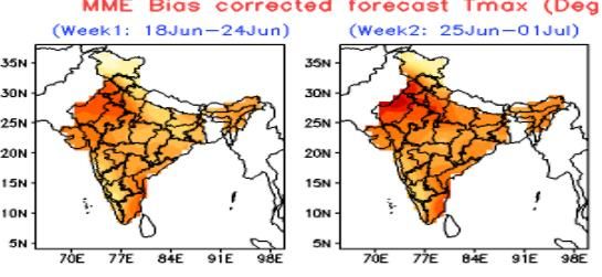
e. Forecast for next two week
   Weather systems & associated Precipitation during Week 1 (17 to 23 June, 2021) and Week 2 (24-
   30 June, 2021)

   Advance of southwest monsoon:
 ➢    Present impact of Middle latitude westerly on monsoon likely to continue during week 1, and hence
   advance of monsoon into Rajasthan, remaining parts Punjab, Haryana and Delhi are not likely during the
   same period. However, there could be slow progress into some more parts of Gujarat, Madhya Pradesh
   and Uttar Pradesh during next 2 to 3 days due to favourable local features.
   ➢ Monsoon flow pattern likely to organize and strengthen gradually during 2nd half of the week 2(from
   26-27 June to 30 June) and hence further advance of monsoon likely to most parts of northwest India
   during the same period, outside part of west Rajasthan.
 ➢    The Northern Limit of Monsoon (NLM) continues to pass through lat. 20.5°N/ Long. 60°E, Diu, Surat,
   Nandurbar, Bhopal, Nowgong, Hamirpur, Barabanki, Bareilly, Saharanpur, Ambala and Amritsar as on
   17 June 2021.

   Rainfall for week 1: (17 to 23 June, 2021)
   ➢ A cyclonic circulation lies over Gangetic West Bengal & neighbourhood. It is likely to move northwest
   wards during next 2-3 days. A feeble low-pressure area also likely to form over north Bay around 19 June
   and move to north Jharkhand-Bihar area during subsequent 2-3 days. Under its influence; fairly
   widespread to widespread rainfall activity with isolated heavy to very heavy falls very likely to continue
   over most parts of East India & adjoining east Central India during the week. Iisolated heavy to very
   heavy falls very likely over Bihar, Jharkhand, West Bengal & Sikkim and north Odisha and north
   Chhattisgarh during week1. Cumulatively during week 1, rainfall likely to be normal to above normal
   over eastern and adjoining east central India
   ➢ A cyclonic circulation lies over East Uttar Pradesh & neighbourhood. Under its influence, fairly
   widespread rainfall with isolated heavy to very heavy falls very likely over East Uttar Pradesh during next
   2-3 days with reduction of rain thereafter.
   ➢ An offshore trough runs from south Gujarat coast to north Kerala coast. Under its influence,
   widespread rainfall with isolated heavy to very heavy falls very likely over Konkan & Goa and Madhya
   Maharashtra during next 2-3 days; over Karnataka and Kerala & Mahe during next 2 days. Isolated
   extremely heavy falls also very likely over Konkan & Goa and Madhya Maharashtra during next 24
   hours. Likely reduction of rainfall over west coast of India and also further over interior parts of
   Maharashtra and Karnataka and adjoining interior parts of Peninsular India from 19 June 2021.

                                                                                                6|Page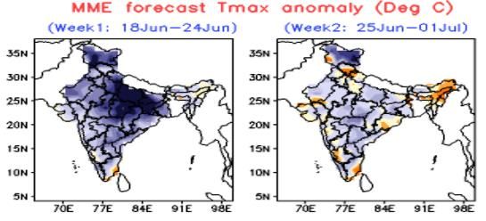
Cumulatively during week 1, rainfall likely to be normal over west coast of India and normal to be
 below normal over rest parts of peninsular India including Andhra Pradesh and Telangana and
 Marathwada.
 ➢ A Western Disturbance as a trough at middle tropospheric levels, runs from north Jammu & Kashmir
 to northeast Arabian Sea. Under its influence, fairly widespread rainfall with isolated heavy to very heavy
 falls very likely over Uttarakhand during next 2 days and isolated to scattered rainfall of light to moderate
 intensity likely over remaining parts of northwest India and Gujarat till 20 June and then its significant
 reduction thereafter. Cumulatively during week 1, rainfall likely to be normal over the region.
 ➢ Due to likely strengthening of lower level southerly/southwesterly winds from Bay of Bengal to
 northeast India towards end of week 1, widespread rainfall activity with isolated heavy to very heavy
 and isolated extremely heavy rainfalls very likely over Northeastern states during from end of week 1.
 Cumulatively during week 1, rainfall likely to be normal to be below normal over the region.
 (Annexure IV).
 ➢ Moderate to severe thunderstorms accompanied by frequent cloud to ground lightning very likely over
 Uttarakhand, Uttar Pradesh, East Madhya Pradesh, Chhattisgarh, Bihar and Jharkhand during week 1.
 This may cause injuries leading to casualties to people and animals staying outdoors.

 Rainfall for week 2: (24-30 June, 2021)
➢ Monsoon flow pattern likely to get organize and straighten due to likely formation of a low pressure
 area over north Bay of Bengal and its further west northwest ward movement during 2nd half of the week
 2. Cumulatively, Normal to above normal rainfall activity with isolated heavy falls likely over some
 parts of east central and adjoining eastern parts of India.
➢ Sub-dude rainfall activity likely to continue over northwest India during 1st half of Week 2 while due to
 gradual establishment of easterly wind from straightening of monsoon pattern over the country, during
 the 2nd half of the week 2, a fresh spell of rainfall likely over the region during the period. Cumulatively
 during week 2, rainfall likely to be normal over some pockets of northwest India except parts of
 western Himalayan region where it is likely to be normal to below normal
➢ Due to likely strengthening of westerly winds and off-shore trough along west coast towards 2nd
 half of the week 2, widespread rainfall with isolated heavy falls very likely along the west coast.
 Hence, rainfall activity is likely to be normal along west coast.
➢ It is likely to near normal remaining parts of the country outside northeastern states and extreme
 southern parts of southern Peninsular India, where it is likely to be below normal. (Annexure IV).

 Temperature for week 1: (17-23 June, 2021)

                                                                                                7|Page
➢ Maximum Temperature Departures as on 17-06-2021: Maximum temperatures were appreciably
above normal (3.1°C to 5.0°C) at isolated places over Arunachal Pradesh and Gujarat State; above
normal (1.6°C to 3.0°C) at most places over Assam & Meghalaya; These are below normal or near
normal over remaining parts of the country.
➢ These are likely to fall by 4-6°C over most parts of Gujarat during next 2-days. No significant
change in maximum temperature over rest parts of the country during for next 7 days except
parts of northwest India, where, it is likely to rise by 3-5 °C from 20 June till 23 June.
➢ No Heat wave condition over any parts of India likely during the period. However due to rise in
temperatures and high humidity, there will be discomfort over northwest India during the 2nd
half of week.
Temperature for week 2: (24-30 June, 2021)
➢ Maximum temperatures are likely to increase slightly as compared to week 1. However, it is likely to be
below normal over most parts of the country outside some pockets of northeast India and Gujarat &
adjoining Rajasthan, where it is likely to be near normal to slightly above normal during the week
(Annexure V).
➢ No heat wave likely over any part of the country during the week.
f. Cyclogenesis:
Considering existing environmental features and model guidance, it may be concluded that no
cyclogenesis likely over the north Indian Ocean during the ensuing 2 weeks. However, there could be
formation of short-lived low pressure areas, one each over north BoB and northwest BoB respectively
during the initial parts of weeks1 & 2.
http://www.rsmcnewdelhi.imd.gov.in/uploads/archive/24/24_4c5d2c_Extended%20Rang
e%20Outlook_17062021.pdf
Next weekly update will be issued on next Thursday i.e. 24 June 2021
8|PageAnnexure I
9|PageAnnexure II 10 | P a g e
Annexure III

Annexure IV

 11 | P a g e
12 | P a g e
You can also read