All India Coordinated Research Project on Agrometeorology - ICAR
←
→
Page content transcription
If your browser does not render page correctly, please read the page content below
All India Coordinated Research Project on Agrometeorology
CRIDA, Santoshnagar, Hyderabad – 500 059
Daily Crop Weather Information as on 11 May 2021
Attention: Rajiv Maheshwari, OSD, ICAR
Significant Weather Features (IMD)
In view of likely Cyclonic storm formation over south Arabian Sea around 15 May
2021 and its likely north-northwestwards movement, heavy to very heavy rainfall
is likely at a few places over Kerala and Lakshadweep on 14 and 15 May and also
over of Tamilnadu and south Karnataka on 15 May. Fishermen are advised not to
venture out to the southeast Arabian Sea and adjoining Maldives, Comorin and
Lakshadweep area, Kerala coast from morning of 13 May and east central Arabian
sea and along and off Karnataka-Goa and Maharashtra and Goa coasts from 14th
Night. Those, who are in Sea are advised to return to coast by night of 12th May,
2021
A Western Disturbance as a trough runs along Longitude 67ºE and north of
Latitude 28ºN in middle tropospheric levels. A cyclonic circulation lies over
Central Pakistan & adjoining northwest Rajasthan and an east-west trough runs
from this cyclonic circulation to Assam at lower levels. In addition, there is likely
confluence of winds from Arabian Sea and easterly winds at lower levels over
northwest India during next 3-4 days. Under the influence these systems, fairly
widespread to widespread rainfall with isolated thunderstorm/lightening/gusty
winds & hailstorm very likely over Western Himalayan Region and scattered to
fairly widespread rainfall with isolated thunderstorm/lightening/gusty winds
over plains of northwest India during next 3-4 days. Isolated heavy rainfall is also
likely over Jammu & Kashmir on 12 May; over Himachal Pradesh & Uttarakhand
on 12 & 13 May and over Punjab on 13 May, 2021.
Under the influence of above mentioned east-west trough at lower levels and
north-south trough over northeast India at middle tropospheric levels, scattered
to widespread rainfall/thunderstorm activity is very likely over northeastern
states and West Bengal & Sikkim; and isolated to scattered rain/thundershower
over rest parts of east India during next 5 days. Isolated heavy rainfall is also
likely over Assam & Meghalaya on 11 & 12 May; Tripura on 11 May; Sub
Himalayan West Bengal & Sikkim on 11 & 12 May, 2021 and over Gangetic West
Bengal from 11 to 13 May, 2021.
1 No heat wave is likely over any part of the country during next 5 days
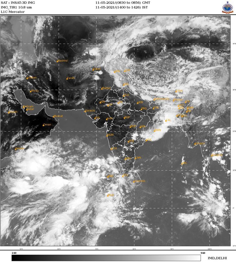
The images showing the latest satellite picture in the figure. 1.
Main Weather Observations (IMD)
Rain/Thundershowers observed (from 0830 hours IST of yesterday to 0830 hours
IST of today): at most places over Jammu, Kashmir, Ladakh, Gilgit-Baltistan and
Muzaffarabad, Arunachal Pradesh and Kerala & Mahe; at many places over
Assam & Meghalaya, Himachal Pradesh, East Madhya Pradesh, Jharkhand, Sub-
Himalayan West Bengal and Chhattisgarh; at a few places over Nagaland,
Manipur, Mizoram & Tripura, Odisha, Punjab and Andaman & Nicobar Islands;
at isolated places over Haryana, Chandigarh & Delhi, Uttarakhand, Rajasthan,
Bihar, West Madhya Pradesh, Gangetic West Bengal, Odisha, Vidarbha,
Telangana, Interior Karnataka, Tamilnadu, Puducherry & Karaikal and
Lakshadweep.
Hailstorm observed (at 0830 hours IST of today)at isolated places over Telangana,
Chhattisgarh and Vidarbha.
No Heat Wave observed.
Duststorm/Thunderstorm observed (from 0830 hours IST of Yesterday to 0830
hours IST of today): at isolated places over West Rajasthan.
Thunderstorm observed (from 0830 hours IST of Yesterday to 0830 hours IST of
today): at many places over Kerala & Mahe; at a few places over Odisha, East
Uttar Pradesh Coastal Karnataka and Lakshadweep; at isolated places over
Jammu, Kashmir, Ladakh, Gilgit-Baltistan and Muzaffarabad, Himachal Pradesh,
Haryana, Chandigarh & Delhi, Rajasthan, Punjab, Assam & Meghalaya,
Arunachal Pradesh, Jharkhand, Gangetic West Bengal, West Uttar Pradesh, West
Madhya Pradesh, Telangana, Karnataka, Tamilnadu, Puducherry & Karaikal and
Andaman & Nicobar Islands.
Maximum Temperature Departures as on 10-05-2021: Maximum temperatures
were appreciably above normal (3.1°C to 5.0°C) at isolated places over Assam &
Meghalaya; above normal (1.6°C to 3.0°C) at many places over Jammu, Kashmir,
Ladakh, GilgitBaltistan and Muzaffarabad and Nagaland, Manipur, Mizoram &
Tripura; at a few places over West Rajasthan, Saurashtra & Kutch, Coastal
Karnataka and Kerala & Mahe. They were markedly below normal (-5.1°C or
more) at many places over Chhattisgarh; appreciably below normal (-3.1°C to -
5.0°C) at most places over Bihar;; at many places over Punjab; at a few places over
East Madhya Pradesh and Odisha; at isolated places over Vidarbha and below
normal (-1.6°C to -3.0°C) at most places over Haryana, Chandigarh & Delhi,
2Uttrakhand, East Madhya Pradesh, Uttar Pradesh and Jharkhand; At many places
over North Interior Karnataka, Gangetic West Bengal and Sub-Himalayan west
Bengal & Sikkim; at a few places over Himachal Pradesh, west Madhya Pradesh,
Andaman & Nicobar Islands and Tamilnadu, Puducherry & Karaikal and at
isolated places over Saurashtra & Kutch, Telangana and Coastal Andhra Pradesh
& Yanam and near normal over rest parts of the country. Yesterday, the highest
maximum temperature of 43.9°C was reported at Churu (West Rajasthan).
Minimum Temperature Departures as on 11-05-2021: Minimum temperatures are
appreciably above normal (3.1°C to 5.0°C) at a few places over Himachal Pradesh;
above normal (1.6°C to 3.0°C) at a few places over Jammu, Kashmir, Ladakh,
Gilgit-Baltistan and Muzaffarabad, West Rajasthan, Konkan & Goa, Madhya
Maharashtra and Rayalaseema; at isolated places over Punjab, Gangetic West
Bengal, Odisha, Saurashtra & Kutch, Coastal Andhra Pradesh, North & South
Interior Karnataka, Kerala & Mahe and Tamil Nadu, Puducherry & Karaikal.
They are markedly below normal (-5.0°C or less) at many places over
Chhattisgarh; at a few places over East Madhya Pradesh and at isolated places
over Telangana and Gujarat Region; below normal (-1.6°C to -3.0°C) at many
places over Nagaland, Manipur, Mizoram & Tripura and Bihar ; at a few places
over Assam & Meghalaya, Haryana, Chandigarh & Delhi, East Rajasthan, West
Madhya Pradesh and Vidarbha and at isolated places over Sub- Himalayan West
Bengal & Sikkim and East Uttar Pradesh and near normal over rest parts of the
country. Today, the lowest minimum temperature of 17.5°C reported at Pendra
Road (East Madhya Pradesh) over the plains of the country.
Weather Warning during the next 5 days (IMD)
11 May (Day 1): Thunderstorm with lightning, hail & gusty winds (speed
reaching 30-40 kmph) very likely at isolated places over Jammu & Kashmir,
Ladakh, Gilgit-Baltistan & Muzaffarabad, Himachal Pradesh, Uttarakhand,
Chhattisgarh and Telangana; with lightning & gusty winds (speed reaching 40-50
kmph) very likely at isolated places over Bihar and Odisha; with lightning &
gusty wind (speed reaching 30-40 kmph) at isolated places over Punjab, Haryana,
Chandigarh & Delhi, Madhya Pradesh, Vidarbha, Jharkhand, West Bengal &
Sikkim, Assam & Meghalaya, Nagaland, Manipur, Mizoram & Tripura and
Kerala & Mahe; with lightning at isolated places over Uttar Pradesh, Arunachal
Pradesh, Madhya Maharashtra, Marathwada Coastal Andhra Pradesh & Yanam,
Rayalaseema, Karnataka, Tamil Nadu, Puducherry & Karaikal and Lakshadweep.
Thunderstorm/Duststorm (speed reaching 40-50 kmph) very likely at isolated
places over Rajasthan. Heavy Rainfall very likely at isolated places over West
3Bengal & Sikkim, Odisha, Assam & Meghalaya, Nagaland, Manipur, Mizoram &
Tripura, Coastal & South Interior Karnataka, Tamil Nadu, Puducherry & Karaikal
and Kerala & Mahe. Squally Weather (wind speed reaching 40-50 kmph) very
likely over Southwest and adjoining Southeast Arabian Sea and adjoining
equatorial India Ocean, Maldives, Comorin and Lakshadweep area. Fishermen
are advised not to venture into these areas.
12 May (Day 2): Thunderstorm with lightning, hail & squall (speed reaching 50-60
kmph) very likely at isolated places over Punjab, Haryana, Chandigarh & Delhi;
with lightning, hail & gusty winds (speed reaching 30-40 kmph) at isolated places
over Jammu & Kashmir, Ladakh, Gilgit-Baltistan & Muzaffarabad, Himachal
Pradesh, Uttarakhand and Telangana; with lightning & gusty wind (speed
reaching 30-40 kmph) at isolated places over Uttar Pradesh, Chhattisgarh, Bihar,
Jharkhand, Gangetic West Bengal, Odisha and Kerala & Mahe; with lightning at
isolated places over Madhya Pradesh, Vidarbha, Sub-Himalayan West Bengal &
Sikkim, Assam & Meghalaya, Coastal Andhra Pradesh & Yanam, Rayalaseema,
Karnataka, Tamil Nadu, Puducherry & Karaikal and Lakshadweep.
Thunderstorm/Duststorm (speed reaching 40-50 kmph) very likely at isolated
places over Rajasthan. Heavy rainfall very likely at isolated places over Jammu &
Kashmir, Ladakh, Gilgit-Baltistan & Muzaffarabad, Himachal Pradesh,
Uttarakhand, West Bengal & Sikkim, Assam & Meghalaya, Coastal & South
Interior Karnataka and Kerala & Mahe. Squally Weather (wind speed reaching 40-
50 kmph) very likely over Southwest and adjoining Southeast Arabian Sea and
adjoining equatorial India Ocean, Maldives, Comorin and Lakshadweep area.
Fishermen are advised not to venture into these areas.
13 May (Day 3): Thunderstorm with lightning, hail & squall (speed reaching 50-60
kmph) very likely at isolated places over Punjab and Haryana, Chandigarh &
Delhi; with lightning, hail & gusty winds (speed reaching 30-40 kmph) at isolated
places over Himachal Pradesh, Uttarakhand and Telangana; with lightning &
gusty wind (speed reaching 40-50 kmph) at isolated places over East Rajasthan;
with lightning & gusty wind (speed reaching 30-40 kmph) at isolated places over
Uttar Pradesh, Chhattisgarh, Bihar, Jharkhand, Gangetic West Bengal, Odisha,
Kerala & Mahe and Lakshadweep; with lightning at isolated places over Jammu
& Kashmir, Ladakh, Gilgit-Baltistan & Muzaffarabad, Madhya Pradesh,
Vidarbha, Sub-Himalayan West Bengal & Sikkim, Gujarat state, Coastal Andhra
Pradesh & Yanam, Rayalaseema, Karnataka and Tamil Nadu, Puducherry &
Karaikal. Thunderstorm/Hailstorm/Duststorm (speed reaching 40-50 kmph)
very likely at isolated places over West Rajasthan. Heavy rainfall very likely at
4isolated places over Sub-Himalayan West Bengal & Sikkim, Himachal Pradesh,
Uttarakhand, Punjab, Gangetic West Bengal, Odisha, Kerala & Mahe and
Lakshadweep. Squally wind speed reaching 45 kmph gusting to 55 kmph over
Southeast Arabian Sea and adjoining equatorial India Ocean, Maldives, Comorin
and Lakshadweep area and along and off Kerala coast. Squally Weather (wind
speed reaching 40-50 kmph) very likely over Southwest and adjoining equatorial
India Ocean. 14 May (Day 4): Thunderstorm with lightning, hail & gusty winds
(speed reaching 30-40 kmph) likely at isolated places over Telangana; with
lightning & gusty wind (speed reaching 30-40 kmph) at isolated places over
Punjab, Haryana, Chandigarh & Delhi, Uttar Pradesh, West Rajasthan, Jharkhand,
Konkan & Goa, Madhya Maharashtra, Marathwada, Kerala & Mahe and
Lakshadweep; with lightning at isolated places over Uttarakhand, East Madhya
Pradesh, Vidarbha, Chhattisgarh, West Bengal & Sikkim, Coastal Andhra Pradesh
& Yanam, Rayalaseema, Karnataka and Tamil Nadu, Puducherry & Karaikal.
Heavy to very heavy rainfall likely at isolated places over Kerala & Mahe and
Lakshadweep and heavy rainfall at isolated places over Sub-Himalayan West
Bengal & Sikkim, Coastal & South Interior Karnataka and Tamil Nadu,
Puducherry & Karaikal. Squally wind speed reaching 45 kmph gusting to 55
kmph over Southeast Arabian Sea and adjoining equatorial India Ocean,
Maldives, Comorin and Lakshadweep area and along and off Kerala coast.
Squally Weather (wind speed reaching 40-50 kmph) very likely over Southwest
and adjoining equatorial India Ocean.
15 May (Day 5): Thunderstorm with lightning & gusty winds (speed reaching 30-
40 kmph) likely at isolated places over Jharkhand, Konkan & Goa, Madhya
Maharashtra, Marathwada, Telangana, Kerala & Mahe and Lakshadweep; with
lightning at isolated places over Coastal Andhra Pradesh & Yanam, Rayalaseema,
Karnataka and Tamil Nadu, Puducherry & Karaikal; Heavy to very heavy rainfall
with extremely heavy falls likely at isolated places Lakshadweep; heavy to very
heavy rainfall at isolated places over Coastal & South Interior Karnataka, Tamil
Nadu, Puducherry & Karaikal and Kerala & Mahe. Squally wind speed reaching
50-60 kmph gusting to 70 kmph over southeast Arabian Sea and adjoining east
central Arabian Sea, and along and off Kerala -Karnataka coast, Lakshadweep,
Maldives areas and adjoining equatorial Indian Ocean till night of 15th May. It is
likely to increase with Gale wind speed 60-70 kmph gusting to 80kmph over East
central Arabian Sea and adjoining southeast Arabian Sea and Lakshadweep area
from early morning of 16th May. Squally wind speed reaching 40-50 kmph
gusting to 60kmph also very likely along and off Maharashtra coast. Squally
5Weather (wind speed reaching 40-50 kmph) very likely over Southwest and
adjoining equatorial India Ocean.
The weather outlook for seven days i.e., 11 May to 19 May 2021 forecasted
(Provided by Real-Time Weather Forecasts from NOAA/NCEP collected from
http://monsoondata.org/wx2/) rain/thundershower may occur over Some
parts of Extreme northern parts of India. (Fig. 2).
Agricultural activities (AICRPAM-CRIDA)
South Karnataka
Weather condition:
State actual rainfall for during 29nd April 2021 to 5th May 2021 was 17.0 mm as against
the normal of 12.0 mm with (+) 47 % deviation. Whereas SIK 12.0 mm of rainfall as
against the normal of 16.0 mm leading to (-) 25 % deviation. State actual rainfall for
during 1st January to 5th May 2021 was 106 mm as against the normal of 55 mm with (+)
93 % deviation. Whereas SIK received 107.0 mm of rainfall as against the normal of 70.0
mm leading to (+) 54 % deviation.
Contingency measure:
Animals may be allow for grazing early in morning or later in evening.
Poultry: Poultry management during summer. Average maximum temperature
33-36oC and Average Relative Humidity. Drinking water of 60 lts. of
water/day/animal is required. Clean drinking water be provided to animals and
water troughs should be regularly cleaned Proper ventilation should be
maintained for free circulation of air in the sheds. Periodically water spray
during peak hot hours lowers the temperature and consequently reduces the heat
load on animals . Apply 4-6 inch thick thatch as a roofing material. Water can be
used for spraying the floor and roof of shelter. Incidence of Leaf hopper severe to
spray Azadirachtin (10,000 PPM) @ 7.0 ml/ litre of water.
Dairy: Livestock management during summer: Spray Lamda Cyhalothrin 5EC@
0.5 ml/ litre of water or sulphur dust (SULTAF) 80 W @3g/litre of water against
the Powdery mildew diseases.
Mango : Leaf hopper and Powdery mildew disease incidence is more during
before flowering and immediately after fruit formation to manage spraying of
Carbaryl, 50WP @4g/litre of water or Imidachlorprid @ 0.3ml/ litre of water for
management of leaf hopper.Fruit drop can be controlled by spraying
Naphthalene acetic acid (NAA) @ 20 ppm twice at an interval of 15 days during
the early stage (peanut stage/marble stage) of fruit development stage.If
sufficient water is available, irrigation can be given at 15-20 days interval starting
6from fruit setting till maturity. Provide irrigation, as the fruits are in marble
stage, this will helps for the better development of fruits.
In already harvested fields the farmers are advised to remove the half cutted
stubbles of pigeon pea from their fields. This will avoid multiplication and
spreading of sterility mosaic disease. Seeds may be procured in advance and
store for pre monsoon season sowing of Cowpea, Sesamum, Fieldbean etc. Time
for application tank silt to increase soil fertility. Average Rainfall in April and
May months are 36 mm and 93 mm respectively.
Hence, cowpea, sesame, black gram and green gram are recommended for the
sowing the above crops during May month. Agricultural implements and seeds
may be kept ready for sowing of crops. Taken up summer plough to expose the
soil to kill the different stages of insect and weeds. Bharani rainstar starts from
April 27th and remains upto May 10th. The normal rainfall of Bharani rainstar is
30.7 mm. < 50 % , Average Wind speed < Pedestrian fans may be used to
increase air flow during low wind sunny days. Ensure proper cross ventilation to
avoid ammonia accumulation. Distribute feed in cooler parts of the day (early
morning and in the evening hours). Water tank and lines may be covered with
gunny bags to provide cool water 5 km/hr.
7Figure: 1. Latest available satellite picture as on 11 May 2021 at 1426 Hrs (IST). (Source:
IMD).
8Figure:2. Precipitation forecast for 11 May to 19 May 2021 (Source: NOAA NCEP).
Disclaimer: The predictability of weather depends on many dynamic factors. The success of Agromet advisories provided here
depends on the accuracy of the forecasts. In no event will India Meteorological Department (IMD) and Indian
Council of Agricultural Research (ICAR) be liable to the user or any third party for any direct, indirect, incidental,
consequential, special or exemplary damages or lost profit resulting from any use or misuse of the information on this bulletin.
9You can also read