An information system for historical Cadastre of Venice
←
→
Page content transcription
If your browser does not render page correctly, please read the page content below

e-Perimetron, Vol. 4, No. 4, 2009 [240-246]                                                      www.e-perimetron.org | ISSN 1790-3769

                                                 F. Contò, G. Fanello, M. Pillon∗

                   An information system for historical Cadastre of Venice
                             Keywords: Historical cadastre, Venice, cartographic heritage, digital access

        Summary
        The collaboration between University IUAV of Venice and The State Ar-chive of Venice made pos-
        sible the beginning of a project for the creation of an information system for the Historical Cadastre
        of Venice. The pur-pose of this project is to build a knowledge system of phenomena and process of
        historical transformation of the city that, since the early years of the nineteenth century, set up the
        current state. The Napoleonic, Austrian and Austro-Italian cadastres are the documentation which
        the study is based on. The documents that record the characteristics and ownership of assets - som-
        marioni, extracts and cadastral address books, and maps - are so analyzed and converted into digital
        format. In addition to restitution in raster format, we are also providing for the vectorialization of
        each cadas-tral particle for use in the system, especially for the maps. The problem of correspon-
        dence between the spatial references of historical documents and current geographical spaces, with
        the aim of defining not so only a strict cartographic georeferencing but a criterion for localization, in
        order to read the qualitative similarities and correspondences in evolution of the urban context. For
        access to maps and alphanumeric information is developed Webgis a project based on standards de-
        fined dall'OGC (Open Geospatial Consortium).

                                                          Introduction

The lasting collaboration between “Università IUAV di Venezia” and the State Archive of Venice has
given excellent results. The cartographic heritage of the IUAV was strongly enlarged because of ca-
dastre maps kept in the State Archive had been reproduced in order to be placed at users’ disposal
(both from the university and from external users).Recently the State Archive has planed and started a
high resolution digital acquisition of illustrated documents (such as maps, plans, drawings) kept in the
institute. The availability of those digital cadastral maps made it possible to computerized carto-
graphic documents, as well as the related cadastre registers. Users now allow to have access to search
supplemented with geographical data and information about properties and goods.

                                                           The Project

The historical cadastral base is a basic element for study and research (evolution and analysis of a
city) as well as an important support to whatsoever project concerning goods protected by law re-
straints. According to this, the main aim of the whole project was to create a system of knowledge of
the historical transformations of the city – a phenomenon which from the beginning of the 19th cen-
tury has influenced the actual town scheme. Besides historical cadastres, another aim of this new sys-

∗
    Università IUAV di Venezia

                                                               [240]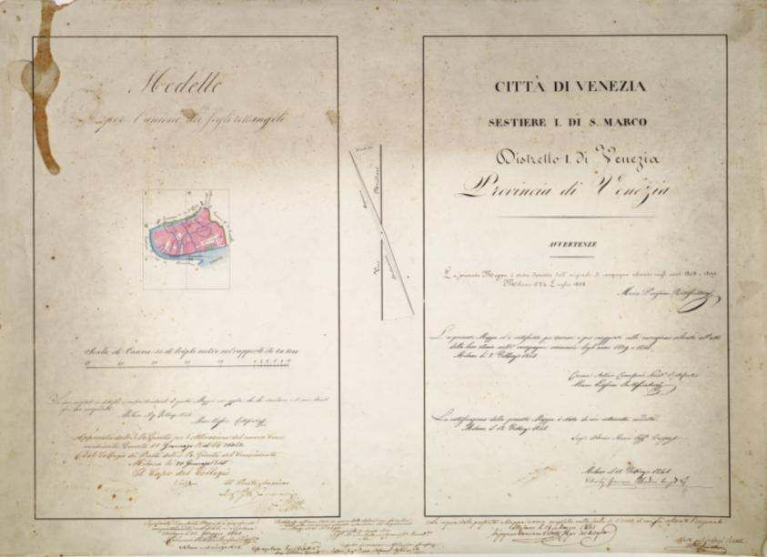
e-Perimetron, Vol. 4, No. 4, 2009 [240-246]                                                     www.e-perimetron.org | ISSN 1790-3769

tem is to widen the study of the town planning scheme towards the current configuration, by adding
both the modern cadastral source and the new digital map.

                                                 The Cadastral Documents

The documents on which this new system is based are three cadastres: the first is the Napoleon’s one,
the second is the Austrian cadastral and the third is the Austo-Italian one. The last one concerns the
extension of the centre of Venice, except for the island of Giudecca. The Napoleonic cadastral is
made up by 29 sheets (two of them reproduce the panel of union) which are in horizontal strips read-
able from left to right. They form a complete map of the whole historical centre. The map behind
draw to a scale 1:1000. Both the survey and the structure dated from 1810-1811. All the information
about properties are in the Sommarioni, very special descriptive catalogue related to each single map
with an identification number. Each number gives some information about the good’s owner, the lo-
cation, the description of the property and its area (given in perches).

                                   Figure 1. Napoleonic Cadastre’s pannel of union of Città Regia.

                                                               [241]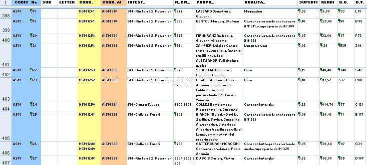
e-Perimetron, Vol. 4, No. 4, 2009 [240-246]                                                    www.e-perimetron.org | ISSN 1790-3769

The Austrian Cadastre, which was started from 1838 and whose maps derived from the Napoleonic
ones, gives a representation of the town divided into sestieri (district) and is made up by 63 sheets –
six of them being panels of union concerning each area district. These sheets developed in horizontal
strips readable from left to right, just like the other ones. The Sommarioni are structured just like the
Napoleonic maps, with the ad-diction of taxable yield. The owners’ name, therefore, is written only
with the initials. Into Estratto catastale (another particular register) there is the agreement between
the abbreviation and the owner’s name, moreover the other prosperities list of the same subject into
Comune Censuario.

                                Figure 2. Austrian Cadastre’s Pannel of Union - Sestiere di S. Marco

The Austro- Italian cadastre is made by 65 sheets with 6 panels of union and derived from the Aus-
trian’s one. As in the Austrian cadastre, the documentation of those cadastre are Sommarioni, Rubri-
cari and Libri Partite, that have a similar function of Estratti catastali..

                                                               [242]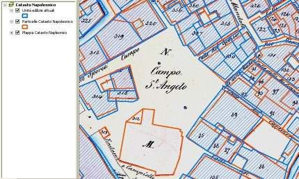
e-Perimetron, Vol. 4, No. 4, 2009 [240-246]                                                    www.e-perimetron.org | ISSN 1790-3769

  Figure 3. From left to right: Sheet IV of Austro-Italian cadastre of San Marco ‘s Sestiere, Sheet 19 of Napoleonic Cadastre of
                          Regia Città di Venezia, Sheet IV of Austrian Cadastre of San Marco’s Sestiere.

                                              Figure 4. Image of San Marco’s Sommarione.

                                                       Preparation of data

The conversion in numeric format is still going on for each single cadastre. The conversion it will be
made for all parts of the different cadastre (from maps to Sommarioni or Estratti catastali). All data
are entered into a specific database, after their classification in different types.

                                                               [243]
e-Perimetron, Vol. 4, No. 4, 2009 [240-246] www.e-perimetron.org | ISSN 1790-3769
Figure 5. Data taken from Austrian San Marco’s Sommarione
Regarding maps, the raster conversion made by the State Archive of Venice is not the unique font of
data. In fact the Sistema dei Laboratori of the University IUAV of Venice is supplying to the digitali-
zation of each single cadastre particle. This process is done to obtain a layer of entities that represent
particles used by the consultation system.
A semi automatic digitalization applied to images – just grey scale or black/white images- has been
used to obtain the layers. To apply this process each single image was modified to remove noise and
to emphasize the relevant geometries (lines, areas, isolated cells etc..). The correction was obtained
sometimes through a automatically process and sometimes manually. The semi-automatic digitaliza-
tion, against of a spare of time, involve a sensible decay of geometry’s quality. Some of “congruence”
features of lines have loosed especially the orthogonal flow and the correct alignment of consecutive
lines of buildings along roads. Moreover it’s possible to recognized sensible gaps from the position of
the arc reconstructed by the software and his position into the reference images. The possibility to test
the different approaches – the automatic and the manually ones – give the evidence that times of work are
the same to obtain the most quality of output geometries. In particular, manually digitalization can also
benefit from the support of the editing, as the control of perpendicular lines and snapping.
The way to manage of information
The project faces the problem of correspondence between spatial reference of historical drawings and
actual geographical space. The aim is not a rigours georeferencing, but a “criterion” for analogies and
correspondences recognitions in urban evolution. In order to obtain this, it was established to bring
the maps back to projective space of the modern maps. The actual maps are reference for the intro-
duction of new geographical layers. The CTR (topographical map) is considered only as a placement
map and not as the basis for a georeferencing in accord to the cartographic projections. The lo-
calization is performed by applying a consequence roto-translation with independent change of scale
for each sheet of paper, without introducing distortion. The set of points obtained by processing each
sheets is applied to the image of the map and to his corresponding vector layer of land parcels.
[244]e-Perimetron, Vol. 4, No. 4, 2009 [240-246] www.e-perimetron.org | ISSN 1790-3769
Figure 6. Image of the modern topographical map on the historical cadastre.
According to all tests, it has been found non-systematic and independent deviations. This kind of data
is alike for the density of the fabric construction and for central or peripheral position within the sin-
gle sheet. The differences are included into a varying range which goes from a few tens of centime-
tres to few meters. So variances can be regarded as acceptable in view of the implementing rules of
the map, its scale, the state of paper and the acquisition procedures. In particular to define the refer-
ence space, the approach was to select into two different windows the same geographical area. Each
single windows showed a different map restrain into the system. This particular procedure doesn’t use
any kind of morphological transformations to the original geometry. So the spatial discrepancy be-
tween maps is limited, while the semantic level remaining complete unchanged. This tool is managed
by a software developed inside the project. The result of the application is to give an immediate visual
indication of urban changes into historical evolution. Therefore the correspondence between particles
of different cadastres is not maintained by the relationship of space, but through relationships en-
coded into tables of alphanumeric data. For example, each particle of the Napoleonic Cadastre report
into their data the codes of the corresponding particles in the Austrian Cadastre and vice versa. So,
from the database, it will be possible to retrieve and compare the data on the evolution of each parti-
cle in historical series.
The System for users
The access to cadastre’s information is developed into a WebGis project based on OGC (Open Geo-
spatial Consortium) standards. The link between the mapping component and the primary narrative
ones (Sommarioni) is determined by particle’s code, while the associated alphanumeric information -
present in the extract or in the land Rubricari- are associated in a sort of database through the identify-
ing owner’s abbreviation. The first response of the system can provide is based on standard criteria
[245]e-Perimetron, Vol. 4, No. 4, 2009 [240-246] www.e-perimetron.org | ISSN 1790-3769
for searching within a database. The WebGis’s interface offers possible guided questions based on the
contents of the data tables. It can therefore draw, for example, all properties belong-ing to the same
holder, the units used for a specific use, and so forth. The inclusion of data which indicate the correla-
tion between particles in different registers allows showing changes in texture and allocation of hous-
ing units. The system ,also, provides the ability to add geographic layers and information not directly
related to each other land to comprehend transformations occurred in the Old Town city.
References
Bonetta R. , Scarso M., 1991, L’informazione dei catasti storici ed attuali dell’area mo-numentale di
San Marco a Venezia, Bollettino della SIFET, n° 3, pp. 125-127.
Marcadella G., ottobre 2008, Progetto di digitalizzazione della cartografia catastale sto-rica di
Vicenza e di Bassano del Grappa, Acta Concordium n° 9, pp.91-98.
Oscar P., 2002, Un sistema informativo per la gestione dei dati di censimento dl catasto storico di
Bergamo: Catasto Lombardo-Veneto (1853) e Nuovo Catasto Terreni (1901), Museo e Storia, anno
IV, n° 4.
Pavanello I., 1976, I Catasti Storici di Padova, Roma, Officina Edizioni. Scarso M., Baso G.,
febbraio 1989, Catalogo dei documenti cartografici - Catasti Storici, Istituto Universitario di
Architettura di Venezia.
[246]You can also read