An Old Ritual Capital, a New Ritual Landscape: Understanding the Transformation of Angkor Thom, Cambodia through the Construction and Placement of ...
←
→
Page content transcription
If your browser does not render page correctly, please read the page content below
An Old Ritual Capital,
a New Ritual Landscape:
Understanding the Transformation
of Angkor Thom, Cambodia through
the Construction and Placement
of Theravāda »Buddhist Terraces«
Andrew Harris*

This paper serves as the first focused study since 1918 exploring the sub-structural remains
of Theravāda Buddhist monasteries, known to scholarship as »Buddhist terraces«, at the
Cambodian Khmer capital of Angkor Thom. Thought to have been constructed between
the late 13th-16th centuries, prayer halls (vihara or praḥ vihar) and other Theravāda build-
ings are seen by traditional scholarship to be the products of an officially undocumented
but visible religious transition from the Khmer Brahmano-Buddhist royal cult, manifested
through the construction of universal temple-mountains and esoteric religious practices, to
a more socially-inclusive monastic tradition which abandoned epigraphy, the deification of
kings, and large-scale religious building. Data acquired from two seasons of site investiga-
tions within Angkor Thom has revealed an expansive collection of over seventy »Buddhist
terraces« demarcated by sīmā boundary stones, suggesting not only a notable Theravāda
building campaign within this cosmologically designed Mahāyāna Buddhist urban space but
also the conversion and incorporation of Brahmano-Buddhist monuments as landmarks of
the new religion. The interaction of Buddhist monastic architecture with non-religious urban
infrastructure, too, most notably the road-grid of Angkor Thom previously mapped through
LiDAR and GIS, has revealed intriguing patterns of construction that appear to match a
configuration with the southerly temple of Angkor Wat, heavily restored as a royally patron-
ized Theravāda sanctuary in the mid-16th century. Understanding the significance of this
shift is necessary to understanding the re-appropriation of the vast urban ritual landscape
of Angkor, and in turn serves as a valid study for further understanding the significance and
retransformation of ritual space transcending specifically-delineated historical epochs.

Keywords: Angkor, Cambodia, Buddhism, Theravada, monasteries, ritual, 16th century, archaeol-
ogy, survey, mapping

*   Correspondence details: Andrew Harris, PhD Candidate, Department of Anthropology, University of Toronto, 19
    Russell Street, Toronto, Ontario, Canada, M5S 2S2; Email: andrewsr.harris@mail.utoronto.ca.

eISSN-Nr. 2412-3196
DOI 10.1553/medievalworlds_no9_2019s4                                    medieval worlds • No. 9 • 2019 • 4-62
5 Andrew Harris
Introduction
Past and present scholarship has typically framed the history of the Khmer Empire (c. 802-
1431 CE) within three distinct phases defined primarily by the religious alignment of kings
and the resulting material remains constructed surrounding their capital center at Angkor.
Working within this academic context while excluding traditions of animistic worship,1 these
three »phases« are traditionally identified as Brahmanic (Śaivism or Vaiṣṇavism), Mahāyā-
na Buddhist, and Theravāda Buddhist.2 The first two »phases« have been delimited and
interpreted through the analysis of temple inscriptions enclosed within monumental tem-
ple-complexes scattered across Cambodia, Thailand, and Laos;3 Brahmanic practice is typ-
ically seen as the Khmer historical norm, while Mahāyāna Buddhism is primary associated
with the great king Jayavarman VII (r. 1181-1220) and his immediate successors’ expansive
campaign of monumental religious construction. Despite the lack of other extant histori-
cal records such as palm-written texts and chronicles due to Cambodia’s tropical climate,
epigraphers have been able to successfully piece together many of the prominent historical
events defining the empire’s first five centuries of existence. Thus, an elite-focused history
of the Brahmanic and Mahāyāna Buddhist »phases« forms the majority of our understanding
of what aspects of Khmer Imperial history are deemed significant.
In contrast, the third religious »phase« of Cambodian history at Angkor is poorly docu-
mented and sparsely researched. Theravāda Buddhism, thought to have been worshipped in
Cambodia as early as the 9th century,4 is believed to have risen to prominence in the late 13th
century5 and is most notably marked by the cessation of temple-building in favor of the con-
struction of less durable, more localized prayer halls. The 1296 CE account of Angkor by the
Yuan Dynasty emissary Zhou Daguan, entitled Customs of Cambodia, has proved invaluable
for understanding Theravāda’s early ascendancy alongside reconstructing Khmer livelihoods
and interactions with religion. Alongside his descriptions of monasteries and bhikkus6 within
Angkor Thom, Zhou proclaimed that »every family practices Buddhism«7 and attests to the
growing dominance of Theravāda practice alongside previous traditions such as Brahman-
ism.8 His descriptions also correlate with the scant historical evidence recovered from a few
short inscriptions from the first decade of the 14th century translated by Cœdès (K.300;
K.470; K.754)9, and later votive epigraphy dated to the »post-Angkorian period« (15th-19th
1 See Groslier, Angkor and Cambodia, 164; Ang, La communauté rurale Khmère, 135-154; Ang, Place of animism,
35-41.
2 Also known as Hinaya, or derogatorily as the »Lesser Vehicle« compared to the Mahāyāna »Greater Vehicle«.
3 See Inscriptions de Cambodge, ed. Cœdès, Vols. 1-8; Lustig et al., Words across space and time, 12-20.
4 Murphy (The Buddhist Boundary Markers, 113) notes that sīmā at Phnom Kulen stylistically dated to the 8th-9th
centuries (199) are more artistically characteristic of Dvaravati examples found on the Khorat plateau instead of
the »leaves« (Ang, Place of animism, 36) found surrounding modern Cambodian monasteries.
5 NARA, Western Prasat Top, 192-193.
6 Monks.
7 Harris, Zhou Daguan, 55.
8 Harris, Zhou Daguan, 52.
9 K.489, a votive Buddhist inscription found at Terrasse Bouddhique No. 1 (Prah Ngok/ATV001) north of the Bayon
temple, is undated but should be noted. The main epigraphic evidence for a Theravāda conversion is the switch
from Sanskrit to Pali as the primary votive language. The final Sanskrit inscription appears at Angkor Wat in 1327
CE (K.470). See Cœdès, Etudes Cambodgiennes, 145-46.
medieval worlds • No. 9 • 2019 • 4-62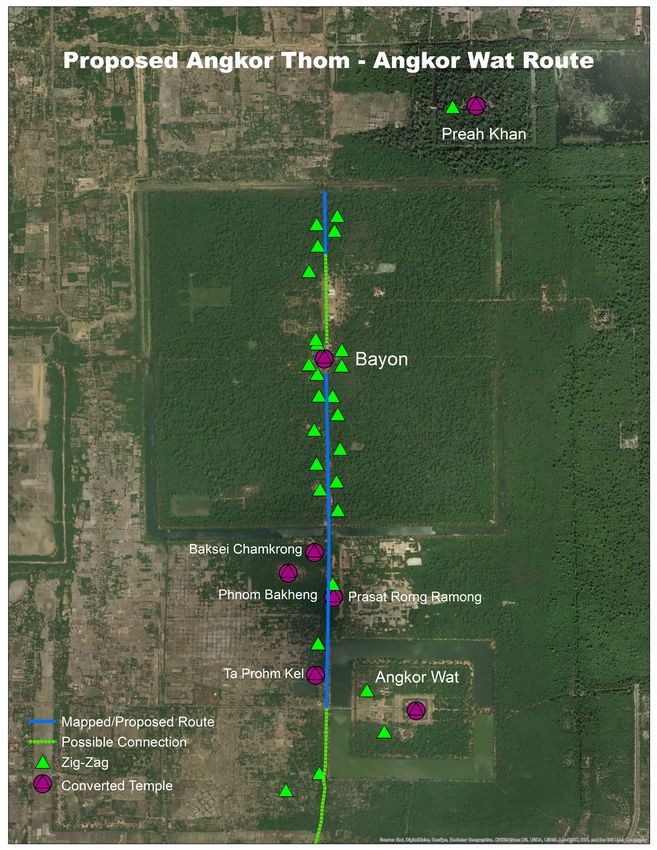
6                                                               An Old Ritual Capital, a New Ritual Landscape

centuries)10 found primarily within the converted Vaiṣṇavaite temple of Angkor Wat.11 How-
ever, the relative lack of epigraphy in comparison to the previous two »phases«,12 as well as
the lack of new temples built under the auspices of imperial power, departs from trends in
traditional Khmer scholarship and its reliance on these sources. This explains in part the
neglect of this important period, and as a result Theravāda institutions and practices have
often been relegated to historical footnotes13 or considered narrowly within the conventional
»decline and fall« narrative of the Khmer Empire14 rather than studied for their own histori-
cal and archaeological merits.
    Following recent trends in Khmer and Angkorian scholarship aiming to explore and
publicize the abundant archaeological evidence from this time period in both Angkor and
greater Cambodia,15 this study will explore relationships believed to exist between the nu-
merous Theravāda Buddhist architectural remains constructed at Angkor Thom between the
late 13th and early 17th centuries. This objective has been undertaken through the analysis
of »Buddhist terraces«, the stone substructural remains of prayer halls delimited by sīmā
boundary stones. Over seventy »Buddhist terraces« have thus far been identified within and
in the immediate vicinity of Angkor Thom, and as ritual architecture these are thought to
have indefinitely replaced Śaivaite and Mahāyāna Buddhist temple-mountains as the prima-
ry focal spaces of religious worship in Cambodia. Typically erected in recycled stone quar-
ried from older temples,16 these substructures provided the mechanism through which the
ancient Khmer capital was ritually validated and politically renewed by Theravāda-practic-
ing populations of the late- and post-Angkorian Periods, and acted to convert Brahmanic
and Mahāyāna Buddhist spaces in a similar manner to the construction of earlier Śaivaite
temple-mountains. »Buddhist terraces« also aided in the repurposing and continued use of
secular infrastructure at Angkor Thom, namely their placement and construction vis-à-vis
the original road-grid of Angkor Thom thought to have first been constructed under Jayavar-
man VII.17 Unique patterns of monastic construction along these roads are also hypothesized
to correlate with the restoration and conversion of several earlier temples. Most notably
Angkor Wat, which became the spiritual hub of Theravāda practice during the reign of King
Ang Chan (r. 1516-1566) and his immediate successors.18 This article thus synthesizes past
studies and presents recently collected material evidence from Angkor Thom to demonstrate
the distinctiveness of this religious transition and the manifestation of Theravāda Buddhism
which has survived in the archaeological record to this day.

10 The first mention of the »post-Angkorian« period comes from Giteau, Iconographie du Cambodge.
11   See Appendix.
12 See study by Lustig et al., Words across space and time, 12-20.
13 Although not always, for example in Thompson, Ancestral Cult in Transition, 273-295; Thompson, Memoires du
   Cambodge, 1-551; Thompson, Buddhist Cosmopolis, 88-119.
14 See Briggs, Ancient Khmer Empire, 54; Cœdès, Indianized States.
15 See fn. 13, 33, 69.
16 Marchal, Monuments Secondaires, 26.
17 Gaucher, L’Archéologie Urbaine, 43. His hypotheses likely come from the establishment of the city, and do not
   come from any published AMS radiocarbon or other dates.
18 Groslier, Angkor and Cambodia, 18; Pou, Inscriptions modernes d’Angkor, 99-126. Thirty-eight translations of
   post-Angkorian inscriptions were published by Pou between 1970-1976. Almost all of these inscriptions were
   found within Angkor Wat.

                                                                          medieval worlds • No. 9 • 2019 • 4-62
7                                                                                                 Andrew Harris

A transformation based on place
»Foundational« acts of place-making in the Khmer Empire, defined by Swenson as »the com-
plex process by which built environments were constructed, maintained, perceived, lived,
and imagined«,19 traditionally consisted of an inscription etched onto a stele or temple door-
jamb. Alongside votive evocations and religious texts, these detailed various royal lineages
or events which occurred during the lives of the respective Khmer kings who commissioned
them.20 The approximately 130021 inscriptions thus far identified have, as noted, customarily
served as the main source of historical interpretation for the lion’s share of medieval South-
east Asian scholarship, and illustrate the role of religious architecture as validations of the
kingship of rulers and »cosmic renewal« of the land over which they ruled.22 Stark notes that
the planning, construction, and worship of architectural and spatial places of worship on an
imperial scale during the Khmer Śaivaite/Vaishnavaite and Mahāyāna Buddhist »periods«
were all factors of this renewal,23 creating social power radiating outwards from a place of
perceived ritual significance.24 It is thought as well that Khmer rites of cosmic renewal were
localized,25 drawing more from the performance of traditional rites than any specific Brah-
mano-Buddhist textual tradition to secure power over local elites.26
    The material result of these repeated ritual performances between the 9th and 13th cen-
turies27 at Angkor is upwards of twenty temple-landscapes, each thought to have formed the
focal points of several meticulously-planned urban/ritual landscapes in the same immediate
region.28 Constructed as monuments central to the propagation of an elite-patronized reli-
gion, Śaivaite temple-mountains and later Mahāyāna Buddhist temple-plains29 formed the
literal focal point of both the mortal and divine universes; heaven (the five peaks of Mount
Meru), earth (the mortal realm), and water (the Universal Ocean) were represented in differ-
ent constructed mediums.30 Similar examples of this degree of urban planning in connection
with ritual elements exist within Mesoamerican temple-cities structured surrounding sacred
pyramid-temple and astrological centers31 and Dynastic Chinese notions of feng shui 32 found
in the construction of cityscapes and palace-complexes to embody the perfect harmonization
of the built environment with the universe.

19 Swenson, Timing is everything, 210.
20 Pottier, Yasovarman’s Buddhist Āśrama, 201.
21 Goodall and Wareham, Gifts of power, 174.
22 Mabbett, Devarāja, 204; Wales, The Universe Around Them, 111; Marston and Guthrie, History, 44;
23 Stark, Southeast Asian urbanism, 75.
24 Brown, Dvaravati Wheels of the Law, 3-10; Marston and Guthrie, History, 91-93.
25 Ang, Place of animism, 35-36.
26 See Geertz, Negara, 1-312; Ang, Place of animism.
27 Ak Yum (7th century) is thought to be the oldest temple mountain in the Angkor region.
28 Wales, The Universe Around Them, 121.
29 Mabbett, Devarāja, 203.
30 Dagens, Cosmogonie et architecture, 1-3.
31 See Coe, Social Typology, 65-85 for an older but innovative comparison.
32 See Meyer, »Feng-Shui« of the Chinese city, 138-155.

                                                                             medieval worlds • No. 9 • 2019 • 4-62
8                                                               An Old Ritual Capital, a New Ritual Landscape

    In these cases, any activity beyond the original intended purpose of a religious monu-
ment, urban area, or landscape remain unclear unless explicitly noted. Thus, the recycling of
spiritual places and continuous place-making as an alternative yet equally validating form of
»cosmic renewal« is poorly researched archaeologically. This comes despite the visible con-
version of numerous Khmer religious complexes, the evidence of which rests in the some-
what problematic seriation of Buddhist images and statues featuring identical mudra and
carving-styles; these have typically been ascribed to the Theravāda tradition in Cambodia
through cross-cultural art-historical comparisons with contemporary polities in northern
and central Thailand such as Ayutthaya and Sukhothai.33 As a result, it proves difficult for
scholars to determine how the perception of material remains reflecting a specific religious
affiliation may have changed either quickly or over time;34 quoting Van Dyke, »archaeological
landscapes are palimpsests – earlier sites and places are avoided, appropriated, reinterpret-
ed, and reconfigured over time« and their products »… followed through life histories that
extend from production through multiple reuse and discard«.35 With that in mind, questions
emerge: why were some sites converted and others abandoned? Was this a religious or secu-
lar decision, and solely based on patterns of urban settlement? How did an augmented tem-
ple or shrine embody a new understanding of universe and polity? How did local or imperi-
al factions influence these monumental conversions? And, more importantly in the case of
Angkor Thom, how did a collective understanding of a monument’s prior ritual significance
factor into any new role it was given by its congregated population?
    The repurposing of Khmer Brahmanic and Mahāyāna Buddhist urban infrastructure for
Theravāda use in the late Angkorian (c. 14th-15th centuries) and post-Angkorian periods
raise all these questions. Arguably nowhere else in Southeast Asia did a single geopolitical
entity undertake such a drastic shift of the overall cosmic worldview while incorporating
such a vast infrastructure of surviving religious monuments from prior affiliations.36 In ad-
dition, the overall structural repurposing of Angkor Thom for Theravāda Buddhist worship,
rather than the traditional foundation of a new politico-religious urban center within Angkor,
represents a fundamental change in previously established traditions of Khmer urban plan-
ning. Angkor Thom was itself constructed in an act of cosmic renewal by Jayavarman VII, and
while the capital absorbed numerous Śaivaite temples into its urban layout, Angkor Thom
itself was a new creation.
    Inclusion of the adoption of Theravāda Buddhism into a narrative of state decline,37 es-
pecially considering that Angkor was indeed abandoned by its Khmer rulers for a series of
successive capitals outside of Phnom Penh in the mid-15th century after a century of domi-
nation by the Thais of Ayutthaya, often lessens any nuanced or even positive observation of

33 See Marchal, Notes sur la forme, 588-589; Giteau, Iconographie du Cambodge, 1-381; Polkinghorne et al., Evidence,
   107.
34 See Shiner, Sacred space, profane space; Assmann, Religion and Cultural Memory.
35 Van Dyke, Imagine pasts imagined, 239.
36 Thompson, Buddhist Cosmopolis, 203-205.
37 Garnier, Ayutthaya, 42.

                                                                            medieval worlds • No. 9 • 2019 • 4-62
9                                                                                                 Andrew Harris

the infrastructural, architectural, or spatial innovations attributed to this period of Theravā-
da practice at Angkor. It is therefore necessary to rethink these material conversions beyond
the reductive narrative of »an absence of new temples«. Instead, Theravāda activity at An-
gkor is best respected as its own era of continuous construction and restoration within the
same ritual landscape, transcending specific religious affiliation but embodying local tradi-
tions associated with the same. Angkor was »Angkor« as much as Yaçodharapura, Harihar-
ilaya, or Indrapaṭṭha at various points in time. These politico-religious centers were inter-
preted through epigraphy, but »Angkor« itself was a timeless place of significance and social
memory38 for populations within Cambodia and Southeast Asia overall.39 Thus, many of the
material remains found within Theravāda-Period Angkor embody a localized »Angkorian«
tradition of construction that does not necessarily correlate with the literal translation of any
inscription or Sanskrit/Pali text. This suggests a uniqueness to the ritual agency of structures
and landscapes within Angkor, indeed communicated through construction, that is not easily
comparable to other regional contexts or Buddhist traditions of monastic establishment. The
distinctiveness found in the transformation of Angkor Thom will be illustrated below.

Reading the Angkor Thom »Grid«
Angkor Thom was both the longest-serving and terminal politico-religious center built in the
Angkor region. Founded as Indrapaṭṭha 40, Angkor Thom was commissioned by Jayavarman
VII during the late 12th century and was noted by Zhou Daguan as continuing to serve as the
principal political center of the Khmer Empire as of 1296 CE. Fifteenth century Thai chroni-
cles also suggest Indrapaṭṭha (Phra Nakhon) as the walled »city« sacked at various points by
Ayutthayan armies during the mid-late 14th century, which was then definitively defeated at
some point surrounding the year 1431.41
    Much like other Khmer politico-religious centers, this 3x3km urban area embodied the
Indic universe with physical manifestations of the divine and mortal realms. In that same
vein, Angkor Thom physically represented the Churning of the Ocean of Milk, an episode of
kingship validation from Brahmano-Buddhist mythology. The moat surrounding the capital
represented the World Ocean, while each causeway into the city was constructed with a row
of carved devas and asura demons. Each row of figures held an enormous naga, the churning
mechanism. At the center of the city stood the Bayon Temple42, an architectural pantheon of
Brahmano-Buddhist deities that was constructed to embody both Mount Meru, home of Lord
Indra, and Mount Mandara, the churning post.43 The date of the consecration of the Bayon
is unknown, as a dedication inscription has never been recovered, but the 216 face-towers
which rise from all three enclosures of the temple give stylistic evidence for the foundation
of the temple to have occurred during the reign of Jayavarman VII (r. 1181-1220 CE).44

38 Swenson, Interpreting the political landscape, 472.
39 Aasen, Architecture of Siam, 61.
40 Jacques, Khmer Empire, 296.
41 Vickery, 2k/125 fragment, 55-56; Vickery, Cambodia and its neighbors, 3; Polkinghorne et al., Evidence, 116-117.
   A discussion on the Luang Prasoet (LP) Ayutthayan chronicles and recent unpublished inscriptions can be found in
   Polkinghorne et al., Evidence, fn. 93, 96.
42 See Appendix for image and floorplan of the Bayon.
43 Williams, Churning of the Ocean of Milk, 151; See also Mus, Sourire d’Angkor, 363-381.
44 Clark, The Bayon, 178.

                                                                            medieval worlds • No. 9 • 2019 • 4-62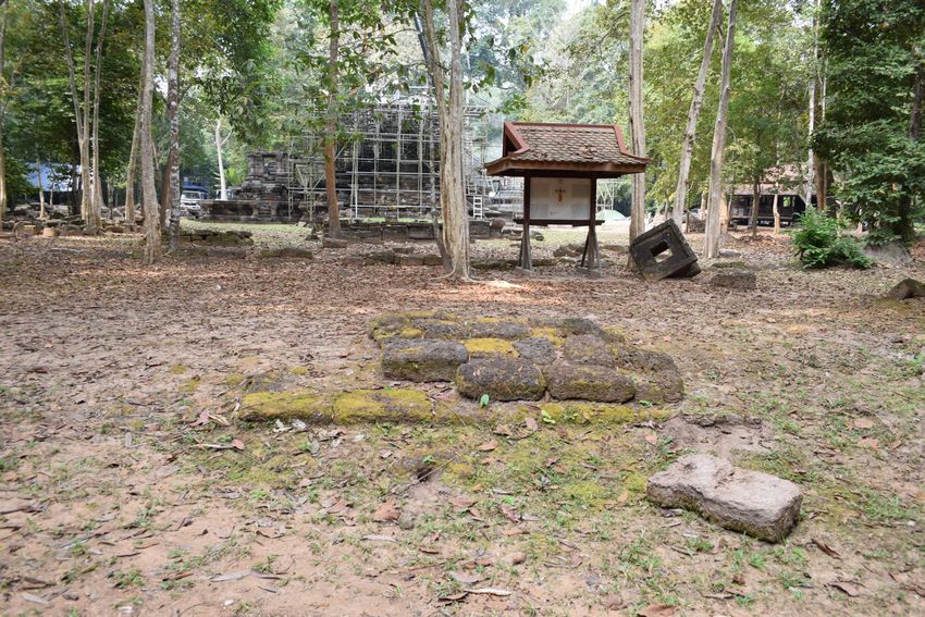
10                                                             An Old Ritual Capital, a New Ritual Landscape

    The construction of the capital also transformed the emplacement and interrelationship
of ritual and vernacular structures. However, since almost all non-religious or non-imperial
buildings were built of perishable wooden architecture, the reorganization of space is poorly
understood.45 Mapped both by Gaucher46 and through more recent LiDAR investigations,47
what remains is a grid-plan of roads. This urban road network was assumedly laid down dur-
ing the reign of Jayavarman VII,48 and the canal/moat system flowing northwest to southeast
from the Siem Reap River through the capital are also thought to have been installed during
this time.49
    The grid-plan of Angkor Thom is dominated by five arterial roads. Crossing under each
gopura 50, these formed the main thoroughfares entering and exiting the capital. Four of
these roads were perfectly cardinally aligned, radiating outward from the Bayon, and divid-
ed Angkor Thom into four subcardinal quadrants; these have often defined a monument’s
location within the capital.51 The fifth, the Victory Gate Road, terminated at the Jayavarman
VII-era Terrace of the Elephants fronting the 10th-century Royal Palace. As earlier scholars
correctly hypothesized,52 LiDAR and GIS analysis has proved that this road likely predated
Jayavarman VII, as the eastern terminus of the Victory Gate Road appears to have been the
shore of the late-9th-century East Baray marked by a large cruciform building similar in
structure to a contemporary mandapa found fronting numerous temples such as Angkor
Wat.53
    As a result of the heavily favored eastern alignment of Śaivaite and Mahāyāna Buddhist
structural layouts,54 almost every ritual feature within Angkor Thom faces east. The grid
system appears to also embody this preference, with nearly twice the number of east-west
(latitudinal) running roads than those laid on a north-south (longitudinal) alignment. This
created rectangular city blocks inside a near-perfectly square city, varying in size,55 and as
a result many smaller religious monuments are flanked on both sides by latitudinal roads
without a single longitudinal road in proximity.
    Previous ground surveys56 have shown that the smaller non-arterial roads which cut
through the majority of these city blocks measure a maximum of 3km long and 18m wide,
and are visible as long, slightly depressed ditches across the otherwise flat landscape.57 Thus,
structures built in direct association with these roads appear to be raised, and in several cases,
laterite staircases were sometimes constructed to reconcile the gentle slope between the road

45 Thompson, Buddhist Cosmopolis, 200.
46 Gaucher, Une utopie réalisée, 64.
47 Evans et al., LiDAR, 1-6.
48 Gaucher, L’Archéologie Urbaine, 41-42.
49 See Groslier, La cité hydraulique angkorienne, 161-202; Fletcher et al., Water management network, 658-670.
50 Gate.
51 Gaucher, L’Archéologie Urbaine, 43.
52 Cœdès, Indianized States, 174-176; See Dumarçay and Royère, Cambodian Architecture.
53 See Hendrickson, Historic routes to Angkor, 480-496; EFEO, JF 07, 158-166.
54 Gaucher, The city of Angkor, 48-49.
55 City blocks range in size from approximately 145x80m to 285x365m (measured using ArcGIS).
56 Gaucher, Archaeology and town planning, 2.
57 Gaucher, Une utopie réalisée, 67-68.

                                                                          medieval worlds • No. 9 • 2019 • 4-62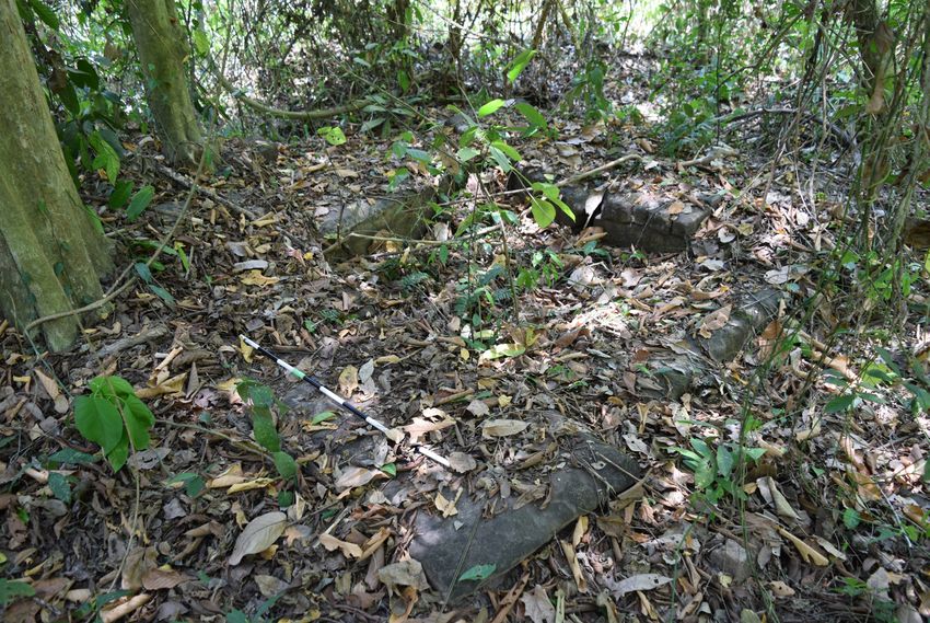
11                                                                                 Andrew Harris

and the monuments in question. A visible example of this placement survives at Western
Prasat Top Temple (Fig. 1.0), where burnt sindora wood excavated to the southwest of the
temple’s »Buddhist terrace« returned AMS radiocarbon dates between 1270 and 1360 CE;
NARA has interpreted this range as the upper limit range of the initial Theravāda Buddhist
renovation of the temple.58

Fig. 1.0: Remains of laterite staircase to and from Western Prasat Top Temple and Buddhist ter-
race facing a cleared »local« road.

   This grid system both incorporated older monuments and spatially prescribed the erection
of newer constructions. For example, the Baphuon temple, an early-11th-century Śaivaite
temple-mountain located just north of the Bayon, formed the terminus of a non-arterial
(secondary or local) latitudinal road running through the Northwest Quadrant of the capital;
as a result, this particular road is not equidistant between the East Gopura and Victory Gate
Roads, located 62m closer to the latter. In contrast, the small 1295 CE-founded Śaivaite
Mangalartha temple, the final temple with a dedication inscription, was built in direct asso-
ciation with the same latitudinal road some 50m to the south. Thus the main difference be-
tween these two temples within the Angkor Thom grid system, aside from their size and var-
ied time periods of construction, was the way in which each monument »interacted« with the
urban landscape: the grid system was built to integrate the Baphuon, while the Mangalartha
appears to have been constructed in relation to the surrounding roads. Spatial analysis, in
this case, can be used as a form of relative dating to determine monuments constructed be-
fore and after the implementation of the Angkor Thom road-grid.

58 NARA, Western Prasat Top, 192-193.

                                                              medieval worlds • No. 9 • 2019 • 4-62
12                                                            An Old Ritual Capital, a New Ritual Landscape

»Buddhist Terraces«: Architectural Layout and Ritual Diacritics
It is indeed possible that this grid-plan of local and arterial roads remained in use up until
Angkor Thom’s definitive abandonment. The most notable evidence for this comes not from
excavations along the grid,59 but through the analysis of the stone and laterite substructures
of over seventy substantial Theravāda monastic buildings (Figs. 2.1-2.4). A handful of these
constructions were first mapped and cleared by Lunet de Lajonquière (1911),60 and more than
sixty others were identified by Marchal (1918),61 Parmentier (1930),62 Trouvé (1935),63 Pottier
(1999),64 and Gaucher (2004) 65 during the 20th century. Marchal, the only scholar thus far
to have focused a publication on these remains, grouped them under the all-encompassing
structural category of terrasses bouddhiques – »Buddhist Terraces«.66 Since this 1918 publi-
cation, Buddhist terraces have been incorporated as evidence of larger arguments exploring
Theravāda activity at Angkor, but have thus far not been extensively researched nor has the
term itself been properly deconstructed.67 This inattention appears due to a lack of epigraphic
evidence, and Buddhist terraces were commonly relegated to the status of »secondary mon-
uments«68. Furthermore, the only Buddhist terraces that have been studied in any detail are
those identified within Angkor Thom; a small number exist in the vicinity of other temples at
Angkor but are not analyzed in any publication beyond their relative cartographic positions.69

59 These were undertaken from 1992-2004. See Gaucher, Une utopie réalisée, 67-69.
60 Lajonquière, Carte du Groupe d’Angkor.
61 Marchal, Monuments Secondaires, 37.
62 Parmentier, Carte du Groupe et du Parc d’Angkor.
63 Trouvé, Angkor: Le Groupe.
64 Pottier, Carte Archéologique.
65 Gaucher, Schema Directeur.
66 Marchal, Monuments Secondaires, 1-40.
67 See Giteau, Bornage Rituel, 44; De Bernon, About Khmer monasteries, 203; Thompson, Buddhist Cosmopolis, 12;
   Harris, Cambodian Buddhism, 36-67.
68 Marchal, Monuments Secondaires, 1-2.
69 World Monuments Fund, Preah Khan Conservation Project, 30-31; Polkinghorne et al., Evidence, 118.

                                                                          medieval worlds • No. 9 • 2019 • 4-62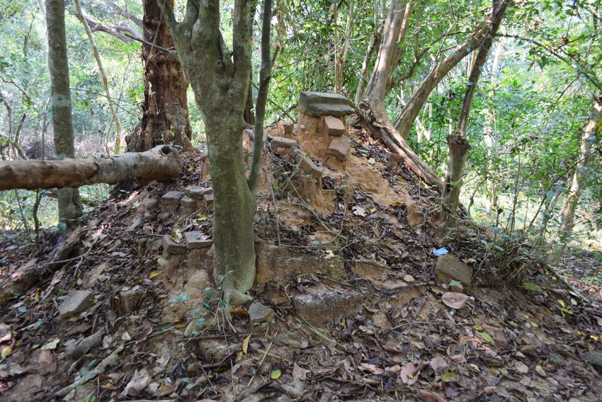
13                                                                                     Andrew Harris

Fig 2.1 (3): Terrace adjacent to Preah Pithu Temple X (Ta Tuot) (ATV016), Terrace J (ATV043), and
Terrace Q (ATV037), Angkor Thom: three Buddhist terraces in varied states of clearance/preservation.

                                                                  medieval worlds • No. 9 • 2019 • 4-62
14 An Old Ritual Capital, a New Ritual Landscape
Fig 2.2.: Scaled photogrammetric floorplan with measurements of Terrasse Bouddhique III/Prah
Eintep (ATV003), Angkor Thom. Note: the seated Buddha is covered by the roof of a modern
pagoda.
Temples affiliated with both Theravāda and Mahāyāna practice, for example the Rajen-
dravarman-era (944-968 CE) sanctuary of Bat Chum (K.266),70 were constructed at Angkor
alongside Śaivaite temples as early as the 10th century. Furthermore, a Buddhist āśrama
was built under Yasovarman I (r. 889-910 CE) in proximity to his state temple at Pre Rup.71
As stated, Zhou Daguan provides the first account of an active sangha 72 at Angkor in 1296
CE,73 noting »for their temples … there is just one icon, an exact likeness of the Sakyamuni
Buddha … it is clothed in red, sculpted from clay, and painted in many colors«,74 a likely ref-
erence to the large sandstone statues which form the ritual focal points of many Buddhist
terraces identified in this study. Zhou also mentions a royal procession he witnessed, during
which »the King« visited »a little golden pagoda in front of which stood a golden statue of the
Buddha«.75 While Zhou Daguan describes saffron-robed monks during this time period, he
gives no real indication as to where they practiced beyond »temples«. Vihāra or prayer halls,
are also mentioned within a handful of inscriptions from the 14th century, most notably the
Pali-engraved K.75476 dated to 1309 CE77 which describes the dedication of one such building
by Indravarman III (r. 1295-1308) prior to his abdication of the throne to pursue the life of a
70 See Sharrock, Garuda, Vajrapani, and Change, 130.
71 See Pottier, Yasovarman’s Buddhist Āśrama, 199-208; Estève and Soutif, Les Yasodhāśrama, 331-355.
72 Monastic order.
73 Zhou is often inaccurate in his identifications of religion beyond the knowledge he carries from a Chinese context.
For example, he frequently notes the presence of Taoist worshippers (Haris, Zhou Daguan, 52-55), a tradition not
endemic to Cambodia during the Angkorian period.
74 Harris, Zhou Daguan, 52. Also see Harris, Cambodian Buddhism, 67.
75 Harris, Cambodian Buddhism, 38.
76 Found at Wat Kok Kphos Temple, Siem Reap Province.
77 Thompson, Memoires de Cambodge, 46.
medieval worlds • No. 9 • 2019 • 4-6215 Andrew Harris
bhikku.78 This inscription is one of very few; as Lusting et al.’s extensive tabulations have il-
lustrated, inscriptions from the 14th century onwards are incredibly rare and thus pass down
to scholars a jarringly incomplete historical record.79
Alongside large-scale renovations to pre-existing temples such as Angkor Wat, Western
Prasat Top, the Bayon, the Baphuon80, and Phnom Bakheng, Buddhist terraces and stupas of
varying sizes are thought to be the only durable buildings constructed at Angkor during both
the late- and post-Angkorian periods. As noted, these originally supported a wooden super-
structure and were covered by a tall roof applied with thatch or tile.81 Despite being markedly
smaller than earlier Brahmano-Buddhist constructions, the surface area of a »Buddhist ter-
race« was larger in area than the central sanctuary of any temple or shrine. This larger hall
was necessary to accommodate a larger congregation, which physically marked the shift to
more inclusive religious practice at Angkor.82
The basic floorplan of a Buddhist terrace consists of an earthen mound, not dissimilar to
the foundations of a temple, leveled and shaped by varying numbers of tiered retaining walls
erected in sandstone or laterite. Floors were earthen, wooden, or tiled flagstones, and were
often adorned with guardian statues (seṇ) or naga balustrades. The central sanctuary com-
prised of a large stone pedestal or collection of sandstone altars located on the easternmost
edge of the highest tier, and either a large sandstone standing or seated Buddha would have
been placed atop this pedestal; these sculptures today rarely exist in situ unless they were
reconstructed (Fig. 3.0). Some Buddhist terraces are also associated with large octagonal or
square stupas, either in proximity to or directly to the west of the central sanctuary following
the same linear trajectory; others are surrounded by smaller stupas, the number of which
suggests continuous significance and patronage of the monastery over time (Figs. 4.1-4.2).
In some cases, a stone or laterite processional path would connect the terrace from a local or
arterial road. All but three Buddhist terraces thus far identified are east-facing.
78 Epigraphers believe this event to have begun the disassociation of kings with Gods (Wales, The Universe Around
Them, 123); a Śaivaite monarch is thought to have ruled until he died or was deposed by a rival.
79 Lustig et al., Words across space and time, 12-20.
80 A recent study by Leroy et al. (First Direct Dating) has dated the 85m Parīnirvana image on the western side of the
Baphuon within a range of 1408-1451 CE through AMS radiocarbon, taken from charcoal fragments embedded in
iron crampons used to support the relief.
81 Zhou Daguan notes that tile was reserved for elite or religious structures (Harris, Zhou Daguan, 49-50); roof-tiles
have thus far been identified surrounding forty-one Buddhist terraces.
82 Harris, Cambodian Buddhism, 36.
medieval worlds • No. 9 • 2019 • 4-6216 An Old Ritual Capital, a New Ritual Landscape
Fig. 3.0: Photogrammetric model of a Seated Buddha in situ, Preah Palilay Bud-
dhist Terrace (ATTS001).
medieval worlds • No. 9 • 2019 • 4-6217 Andrew Harris
Beyond these basic parameters, the architectural variation of Buddhist terraces found at
Angkor Thom is noteworthy. Structures built on more vertical earthen mounds (1.9-4.2m in
height) appear to have originally been Śaivaite or Mahāyāna Buddhist shrines renovated for
Theravāda use, evident from the absence of pedestals in favor of square depressions resembling
the interior of a prasat 83 (Fig. 5.0) or visible renovations made to the original masonry of the
structure visible as an architectural »break« (Fig. 6.0). Those with flatter, tiered rectangular
structures, meanwhile, bear a striking resemblance to the late-14th-16th-century monastic
structures found in abundance at the successive Thai capitals of Sukhothai and Ayutthaya (Fig.
7.0); in Thailand, these were primarily constructed in baked brick and finished with plaster.84
Fig. 4.1: Photogrammetric model of square-based laterite Buddhist Shrine, Terrasse Bouddhique
II/Prah Kok Thlok (ATV002)
83 Temple tower.
84 Doehring, Buddhist Temple Building in Siam, C-3; Marchal, Monuments Secondaires, 15; Garnier, Ayutthaya, 42;
See Appendix for a longer discussion on architectural comparisons between Angkor and Ayutthaya.
medieval worlds • No. 9 • 2019 • 4-6218 An Old Ritual Capital, a New Ritual Landscape
Fig. 4.2: Photogrammetric model of a stupa, Terrace S (ATV057). Reconstructed under Par-
mentier in 1929.
Thai influence on Angkorian Theravādin architecture and statuary85 is to be expected dur-
ing this period, considering the encroachment of Ayutthayan control towards Angkor which
occurred prior to its »abandonment«.86 The practice of Theravāda Buddhism in Cambodia is
also thought to have been heavily influenced by Thai traditions, despite gathered evidence
to suggest that religious connections were forged between Cambodia and Theravāda polities
in Sri Lanka.87 As a result, indirect or direct Sukothai or Ayutthayan influence on Angkor,
possibly even because of direct occupation,88 is thought to have occurred in the later years of
the Khmer Empire.
85 See Giteau, Iconographie du Cambodge, 142.
86 Briggs, Ancient Khmer Empire, 244; Vickery, Cambodia and its neighbors, 1-71; Garnier, Ayutthaya, 42; Rooney,
Ancient Sukhothai, 217.
87 Goonatilake, Sri Lanka-Cambodia relations, 196-201. The son of Jayavarman VII, Tamalinda, journeyed to Sri
Lanka with a party of Burmese monks to receive blessing and ordination at the Mahavihara (possibly in Anurad-
hapura) in 1180 CE.
88 See Polkinghorne et al., One Buddha can hide another, 575-624; Polkinghorne et al., Evidence, 99-113.
medieval worlds • No. 9 • 2019 • 4-6219 Andrew Harris
Fig. 5.0: Base of a prasat depression marking the central sanctuary of a possible converted tem-
ple (ATV033), SW Quadrant, Angkor Thom. Scale = 1m.
medieval worlds • No. 9 • 2019 • 4-6220 An Old Ritual Capital, a New Ritual Landscape
Fig. 6.0 (2): Architectural »break« between vihāra and original building, Terrasse Bouddhique
No. 4 (ATV009). Shown referenced on original drawing of Buddhist terrace by Henri Marchal
(Monuments Secondaires, Pl. X)
medieval worlds • No. 9 • 2019 • 4-6221 Andrew Harris
The most ritually significant aspect of Buddhist terraces is the presence of sīmā, a series
of blessed buried stone orbs or votive deposits89 demarcating the cardinal and subcardinal
points of the majority of Theravāda monastic structures at Angkor Thom. Above ground,
the placement of sīmā are denoted by carved 8x2 tombstone-shaped boundary markers
(sīmā stones);90 these remain in situ or are overturned in close proximity to their original
positions (Fig. 8.1-8.2). According to the Mahāvagga in the Vinaya Piṭaka of the Theravāda
canon,91 sīmā delineate a place where novice monks can be ordained into the sangha. While
this Pali text declares that any number of blessed objects can be used to demarcate ordina-
tion space,92 the tradition of erecting boundary stones is thought to have originated in Mon
monasteries of the Dvaravati Culture of northern Thailand during the 8th century.93 The
use of sīmā is believed to have then been adopted in Sukhothai as early as the 12th centu-
ry,94 and was later imported to Cambodia,95 though the specifics of this cultural transmis-
sion are unclear. That said, while sīmā vary little from monastery to monastery at the Thai
capitals, thirteen distinct artistic styles and shapes of sīmā have thus far been identified
within Angkor Thom alone, suggesting a degree of individualization of craftsmanship from
monastery to monastery.
89 Marchal, Monuments Secondaires, 9.
90 Giteau, Bornage Rituel, 108.
91 Murphy, The Buddhist Boundary Markers, 88.
92 De Bernon, About Khmer monasteries, 208-211; Murphy, The Buddhist Boundary Markers, 88.
93 Murphy, The Buddhist Boundary Markers, 77.
94 Murphy, The Buddhist Boundary Markers, 201.
95 Jessup, Temples of Cambodia, 236.
medieval worlds • No. 9 • 2019 • 4-6222 An Old Ritual Capital, a New Ritual Landscape
Fig. 7.0 (2): Side-by-side architectural comparison of image house from Wat Phra Si Sanphet (1),
Ayutthaya, and Prah Ngok Buddhist Terrace (ATV001) (2), Angkor Thom.
medieval worlds • No. 9 • 2019 • 4-6223 Andrew Harris
Oddly, no sīmā stones are mentioned within 14th-century inscriptions attributed to early
Theravāda patronage in Cambodia, nor are they mentioned in Zhou’s account, suggesting
that the placement of boundary stones was introduced to Angkor no earlier than the mid-late
14th century, which potentially gives credit to the more dominant city-state of Ayutthaya for
the introduction of sīmā to Cambodia.96 NARA, too, dates the placement of the sīmā at West-
ern Prasat Top to the 16th century, although it is unclear how they come to this conclusion
beyond their studies of block placement through anastylosis.97 In some instances, especially
in more inaccessible areas of Angkor Thom, sīmā surround areas containing only fragmented
statuary and altars (Fig. 9.0).98
Fig. 8.1: Pair of sīmā boundary stones in situ, Terrasse Bouddhique No. 3 (ATV007). Scale = 1m.
Fig. 8.2: Sīmā boundary stone uprooted with visible base, Monument 26 (ATV052). Scale = 0.2m.
96 See Cœdès, Indianized States, 236; Vickery, 2k/125 fragment, 54-56
97 See NARA, Western Prasat Top, 119.
98 Giteau, Bornage Rituel.
medieval worlds • No. 9 • 2019 • 4-6224 An Old Ritual Capital, a New Ritual Landscape
Fig. 9.0: Altar scree demarcated by sīmā, Terrace R (ATV049). Scale = 1m.
Thompson classifies Buddhist terraces and other monastic structures, which she catego-
rizes solely as a post-Angkorian architectural feature, as a ritual hybrid of the traditionally
separate vihāra (prayer hall) and uposathāgāra (ordination hall)99. Thompson cites K.82, an
inscribed stele from the 12th-century Mahāyāna Buddhist temple of Wat Nokor, Kampong
Cham Province, written in both Pali and Khmer, which clearly states that sīmā were placed
surrounding a vihāra during its conversion to a Theravādin sanctuary in 1566 CE.100 Thomp-
son also argues that the term uposathāgāra is not found in any epigraphic sources from the
Angkorian or post-Angkorian periods.101 The placement of sīmā surrounding this structure
therefore permitted both ordination and prayer to take place in a single building, which no
doubt established sīmā-delineated Buddhist terraces as the most significant structures con-
structed within Theravāda Angkor for daily ritual.102 In fact, Buddhist terraces might be best
classified as a specific type of Theravāda architecture resembling Ayutthayan prayer halls,
while the term praḥ vihar might better reference Theravāda spaces in a Khmer context sur-
rounded by boundary stones irrespective of structural form.103
99 Also known as ubosot (Thai) or bot (later Cambodian).
100 Thompson, Memoires du Cambodge, 402-403.
101 Thompson, Memoires du Cambodge, 46.
102 Converted temples such as Angkor Wat were no doubt held in higher regard, and may have been significant enough
to bypass the need for sīmā to conduct rituals. No Theravāda boundary markers have been unearthed directly sur-
rounding Angkor Wat, the Bayon, the Baphuon, or any other converted temple except for Western Prasat Top.
103 The Khmer term prah vihar refers to both Hindu/Mahayana and Theravāda sanctuaries and is today used to refe-
rence many unidentified or unnamed ancient sacred places in modern Cambodia. The term wīhan is used in the
Thai context, as a translation of the more pan-regional term vihāra.
medieval worlds • No. 9 • 2019 • 4-6225 Andrew Harris
Worship directed towards a single monastic structure with multifunctional ritual agen-
cies, atypical to Theravāda worship elsewhere in Southeast Asia, could indeed be directly in-
spired by the »focal point« position of religious areas within prior Khmer religious practices
of Śaivism and Mahāyāna Buddhism. Almost always confined to a single structure, Buddhist
terraces appear as no more than an evolution of the traditional prasat space to suit the ten-
ets of a new religious tradition. While clusters of monastic structures do exist,104 there are
very few areas which embody the layout of a Sinhalese or Thai complex with a single sīmā-
demarcated structure for ordination. Thus, Buddhist terraces reflect the reality that culture
is arguably the heaviest influence on religion regardless of instruction given by any tradition-
al text or sangha lineage.
Infrastructural Interaction: Old Roads, New Monasteries
Two seasons of extensive site investigation were undertaken at Angkor Thom from February-
May 2017 and February-April 2018. Data was initially collected through the layering of
20th-century French hand-drawn maps, GIS data, satellite imagery, and aerial LiDAR data
acquired from Phase I (2010-2011) of the Greater Angkor Project.105 Points of interest were
plotted using ArcGIS and uploaded onto a Garmin Montana 6800, and structures/areas
which were identified as Buddhist terraces/praḥ vihar through ground-truthing were cata-
logued, measured, and photographed (Map 1).
Fifty-nine Buddhist Terraces were catalogued within the walls of the Khmer capital during the
time this study was undertaken.106 As discussed above, this designation denotes sīmā stones in situ,
rather than those salvaged from other monastic structures and placed in the central sanctuary as
votive deposits.107 Alongside these, classified under the label ATV (Angkor Thom Vihār/Vihāra),
twelve Buddhist terrace-type structures without sīmā stones were also noted under the head-
ing ATTS (Angkor Thom Terrace Structure)108. This created a sample size of seventy-one
monastic buildings within a 9km2 area from which to extrapolate data.109
104 See Appendix Section 2 for a discussion on multi-structured monasteries and structural and spatial connections
to Ayutthaya.
105 Evans et al., LiDAR, 2.
106 Many of these structures were identified on maps of Angkor Thom by Trouvé (Angkor: Le Groupe) and by Gaucher
(Schema Directeur) but were never specifically marked as Buddhist terraces. Gaucher’s map notes many now-
catalogued Buddhist terraces as »vestiges maçonnée identifié«, »zone de vestige identifiée«, and »zone de vestige
étendue non-identifiée/zone de vestige ponctuelle non-identifiée«; no attempts at further classification were un-
dertaken. However, in publication, Gaucher briefly glosses over his drawing of a sanctuaire Bouddhique (Terrace
H(ATV012)) (Une utopie réalisée, 72-73), but does little more than present this as an element of his fieldwork.
107 Giteau, Bornage Rituel, 7-8
108 ATTS classifications do not suggest these structures never were surrounded by sīmā; rather, they are no longer in
situ. It is assumed that the sīmā were either removed from their cardinal and subcardinal places of consecration at
an unknown point or the construction of ATTS-classified structures predates the tradition of sīmā used to demar-
cate Theravāda places of worship in Cambodia. More excavation work and absolute dating must be undertaken at
sites without sīmā to determine a possible structural chronology based on boundary stone placement.
109 The original classification of monuments was undertaken through a series of mapping projects (see fn. 60-65)
between 1900-1957, but the numerical system appears individualized by the cartographer (See Table 1).
medieval worlds • No. 9 • 2019 • 4-6226 An Old Ritual Capital, a New Ritual Landscape
Map 1: Location of Theravāda Buddhist monastic structures catalogued within Angkor Thom in
relation to the ancient road-grid. Grid-plan mapping attributed to Gaucher (Schema Directeur)
and Evans et al. (LiDAR, 2).
medieval worlds • No. 9 • 2019 • 4-6227 Andrew Harris
In conjunction with the analysis of LiDAR, the spatial and structural data observed and
documented during this study aided in proving that the Jayavarman VII-era road grid had
a direct impact on the placement and construction of Buddhist terraces at Angkor Thom.
Thus, the urban infrastructure of Angkor Thom likely remained intact following the »aban-
donment« of the Khmer elite class in the mid-15th century. All fifty-nine sīmā-demarcated
Buddhist terraces and twelve non-delineated structures identified at Angkor Thom are con-
structed within 100m of any road, though non-arterial roads were favored for construction
by monastic communities; thirty-two vihāra were built more than 100m away from the city’s
five main arteries. This distribution suggests that monasteries were more likely built to serve
small local congregations, a practice that departed notably from the more centralized yet
exclusive elite worship embodied by earlier Khmer Śaivaite traditions110.
Roads no doubt had a significant influence on the placement and construction of mo-
nastic structures, given that roads also influenced the construction of secular buildings and
domestic dwellings. Buddhist terraces associated with a road running in any direction, even
adjacent to the western side closest to the central sanctuary, were almost always found to
feature raised landscaping in the form of a »tract«111 or »ramp« leading directly from the
road to the monastery. Bridges are also hypothesized to have been used to connect Buddhist
terraces to arterial roads over the dykes which lined them; these may have continued to sup-
ply water into the capital after the 15th century,112 which, in rare cases, are marked with the
remains of guardian statues which stood at the terminus of the bridge; these have, over time,
tumbled into the extant canal dykes. Modern examples of these bridges can be found south
of Angkor in the modern town of Siem Reap, for example at the converted 10th-century tem-
ple of Preah Einkosei, where a (formerly) wooden bridge flanked by guardian statues leads
across the Siem Reap River to the monastery.
The North-South Gopura Road Zig-Zag
Arterial roads are believed to have continuously formed the major thoroughfares within the
capital during the post-Angkorian period despite their terminuses being less clear than ear-
lier epochs. Evidence for this comes from the seemingly largest concentration of Theravāda
monastic structures identified anywhere at Angkor Thom built along the South Gopura Road.
The nine substructures located here, combined with the four monasteries built following
the North Gopura Road, the complex of Tep Pranam, and six identified Buddhist terrace
structures surrounding the Bayon, together form a continuous uninterrupted line of twenty
purpose-built monastic structures spanning 3 km from North to South Gopura. No structure
110 Harris, Cambodian Buddhism, 36; Woodward, Practice and belief, 250. The argument of »inclusivity« vs. »exclusiv-
ity« defined by religious transition is primarily predicated on the expansion of central sanctuary spaces in relation
to prasat, the rapid production of these spaces in non-centralized areas, and the abdication of Indravarman III
rather than his death on the throne as noted in K.754 as a stark contrast to the apotheosis of previous kings. It
should be noted that this argument is less predicated on physical evidence and instead on deductive assumptions
based on the above in lieu of actual inscriptions, but the sudden change in ritual architecture is no doubt note
worthy and also appears to embody a more inclusive tradition. More work is thus necessary to properly assess
social hierarchies vis-à-vis religious practice during the late- and post-Angkorian periods.
111 Marchal, Monuments Secondaires, 24.
112 Fletcher et al., Development of the Water Management System, 65.
medieval worlds • No. 9 • 2019 • 4-6228 An Old Ritual Capital, a New Ritual Landscape
is located further than 110m from either arterial road, and no terrace is constructed fur-
ther than 300m from the next. Furthermore, there is evidence that these monasteries were
staggered, allowing for only one monastic structure to be constructed between each pair of
latitudinal running local roads intersecting each arterial road (See Map 2). No supporting
buildings except for brick-inlaid occupation mounds and stupas were found alongside any
structure south of the Bayon nor north of Tep Pranam, creating a series of single-structure
»focal point« monasteries. These structures may have been more spatially affiliated with
others in the layout than any since-disappeared wooden supporting structures, and may
have also reflected patterns of dense settlement along arterial routes during this period of
Angkor Thom’s history. This fascinating spatial phenomenon was designated the North-
South Gopura Road Zig-Zag.
It is important to note that only thirteen of these structures can be readily associated with
any »zig-zag« based on layout alone, and even then without excavation or accurate radiocar-
bon dates this hypothesis is heavily reliant on spatial association. Tep Pranam for example,
undated but originally housing a 9th-century stele imported from a Buddhist āśrama ded-
icated by Yasovarman I (r. 889-910 CE),113 formed the focal point of its own walled monas-
tic complex, and, similar to others such as Western Prasat Top Temple, featured a »break«
between the original Brahmano-Buddhist building and the rectangular vihāra renovation.
Tep Pranam is therefore really only associated with this zig-zag by extension, being located
along the North Gopura Road, and does not warrant further discussion. The large sīmā-
demarcated vihāra surrounding the Bayon, too, are most likely associated with this temple
and only spatially with a more complex longitudinal alignment of structures; that said, the
Bayon undoubtedly played a role in the establishment of the southern portion of this route as
a ritually-significant monument.
What is odd about these remaining structures is their relative ordinariness compared to
other Buddhist terraces/praḥ vihar and monastic »focal point« structures within the capital.
In terms of base tier structural area, of which the average of all ATV and ATTS structures at
Angkor Thom was measured to be 583.91m2, the cumulative average of these thirteen mon-
uments along the zig-zag was almost 90m2 less at 495.64m2 (Table 1).114 Two converted
temples feature in this layout on the Southern Zig-Zag, and three Ayutthayan-style tiered
structures and one funerary structure were identified, but the majority of these structures
are currently too dilapidated115 to determine the original layout or to complete a definitive
structural typology. Only one features the remains of a monumental Buddha in proximity
to its pedestal. This structural variation is of course significant, and suggests both the te-
nacity of populations to build religious structures along well-traveled urban roads and a
gradual structural morphology which, with further research, may someday successfully be
chronologized.
113 Pottier, Yasovarman’s Buddhist Āśrama, 200.
114 Measurements recorded in the table were taken of the base tier of each structure. In cases where no masonry
could easily be identified, measurements were taken between the four cardinal sīmā.
115 Or have been restored as modern monasteries – see Table 1.
medieval worlds • No. 9 • 2019 • 4-6229 Andrew Harris
Map 2: Map of the North-South Gopura Road Zig-Zag spatial pattern (center), mapped in 2017.
medieval worlds • No. 9 • 2019 • 4-6230 An Old Ritual Capital, a New Ritual Landscape
Table 1: Measurements and structural notes for monasteries mapped as part of the North-South
Gopura Road zig-zag spatial alignment.
A traditional ritual importance surrounding the South Gopura is suggested in Zhou Daguan’s
writings, as he notes: »The seventh month is the time for »rice burning«, when new rice that is
ready for harvesting is ceremoniously received outside the south gate, and burned as an offering
to all the Buddhas«.116 This indicates that such Buddhist affiliations surrounding at least the
South Gopura may have originated as early as Jayavarman VII’s Mahāyāna reforms. Thus, the
ritual construction seen here, at least if undertaken during the late Angkorian period, could be
intentional and in some manner patronized by local sangha groups; it is unclear how involved
kings were in the patronage of religious structures, despite evidence for these events noted in
K.754. In fact, the procession of independent monasteries finds an interesting parallel to the
use of naga balustrades, supporting shrines, cruciform terraces, or guardian statues fronting
the central sanctuary of earlier temple-mountains like Angkor Wat or Phnom Bakheng.
116 Harris, Zhou Daguan, 63. »All the Buddhas« may be indicative of the continued presence of Mahāyāna Buddhism
at Angkor.
medieval worlds • No. 9 • 2019 • 4-6231 Andrew Harris
Using the span of an entire arterial thoroughfare from the North to the South Gopura to
construct a uniformly spaced layout of religious buildings, the zig-zag configuration points
to the continuous cosmological significance of the larger regional spatial configuration of
Angkor Thom beyond site-level sīmā demarcation. Much like Jayavarman VII’s original capital,
the most prominent and significant structure most likely remained the Bayon, with two equi-
distant Buddhist terraces constructed 275 m south demarcating what is likely the southern
ritual or spatial boundary of the former state temple. It could even be argued that this layout
is undoubtedly truer to the original purpose behind the 12th-century construction of Angkor
Thom and that of earlier Khmer temple-complexes: that of ritual significance, regardless of
the way it was manifested.
Interpreting the Larger Theravāda Landscape of Greater Angkor
An additional eight Buddhist terraces have thus far been identified outside of Angkor Thom
during this study.117 Each of these is located within a 2.4km range of one of Indrapaṭṭha’s
five gopura, and five of these are located directly or indirectly proximate to an extension
of the South Gopura Road connecting Angkor Thom to Angkor Wat. Unlikely coincidental,
a number of Buddhist terraces, both purpose-built vihāra and converted temples, are laid
out along this road in a similar zig-zag pattern to what is found on the South Gopura Road.
These include Baksei Chamkrong, the Yasovarman I-era state-temple of Phnom Bakheng,
the Jayavarman VII-era hospital of Ta Prohm Kel, and a small shrine known as Prasat Rorng
Ramong. All four of these temples appear to have been restored in a similar manner to Angkor
Wat. For instance, the central sanctuary of Phnom Bakheng was converted into a colossal
sculpture of a seated Buddha,118 Baksei Chamkrong features a parīnirvana image inside its
central shrine,119 the eastern doorway of Ta Prohm Kel features roundels carved in a post-
Angkorian style in a similar manner to Angkor Wat, and a ruined brick shrine with Theravāda
statue debris is found immediately north of Prasat Rorng Ramong.
117 The map by Trouvé notes an eighth Buddhist terrace southwest of Preah Khan on the shore of the Jayatataka Baray,
but this has proved inaccessible at the time of writing.
118 Late 9th-early 10th century original construction. The seated Buddha was dismantled in 1916 by French conservators.
The outline of a block parīnirvana on the western edge can still be seen. There is also a small bronze buddhapāda
below the eastern side of the temple thought to mark the spot where a monastery previously existed.
119 10th-century original construction. This image is identical in style and size to one found in the bakan of Angkor Wat.
medieval worlds • No. 9 • 2019 • 4-62You can also read