Analysis of Trends, Recurrences, Severity and Frequency of Droughts using SPI: Case of OR Tambo DM, Eastern Cape in South Africa
←
→
Page content transcription
If your browser does not render page correctly, please read the page content below

Analysis of Trends, Recurrences, Severity and
Frequency of Droughts using SPI: Case of OR
Tambo DM, Eastern Cape in South Africa
M Nkamisa
Walter Sisulu University - Mthatha Campus: Walter Sisulu University
Simbarashe Ndhleve ( ndhleve@gmail.com )
Walter Sisulu University https://orcid.org/0000-0003-0428-4824
MDV Nakin
Walter Sisulu University
A Mngeni
Walter Sisulu University
H Kabiti
Walter Sisulu University
Research
Keywords: Agricultural drought, Climate change, Hydrological drought, Meteorological Drought Monitor,
Standardized Precipitation Index
Posted Date: March 22nd, 2021
DOI: https://doi.org/10.21203/rs.3.rs-293389/v1
License: This work is licensed under a Creative Commons Attribution 4.0 International License.
Read Full License
Page 1/20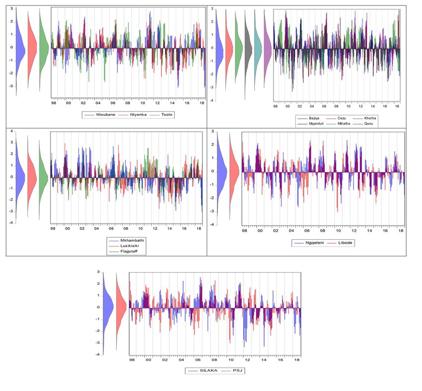
Abstract
South Africa is susceptible to droughts. However, there is little documentation on drought occurrence in
South Africa at national level and its various administrative boundaries. The study aimed to profile the
hydrological drought in ORTDM from 1998–2018; computing their frequency, severity and intensity so as
to show areas of high vulnerability. Data used on this study was obtained from South African Weather
Services in Pretoria. Standardized Precipitation Index (SPI) was calculated using the Meteorological
Drought Monitor (MDM) software computing drought frequency, severity and intensity using 3 and 6
months SPI. The results showed a wide variation in monthly precipitation throughout the year. Coastal
areas receive high rainfall than inland municipalities. When recorded in descending order, the drought
intensity Nyandeni shows the highest drought frequency with a percentage of 62%, Mhlontlo (58%),
KSDM (57%), Ngquza Hill (55%) and Port St Johns showing the least at (52%). The hydrological drought
severity frequency and duration varied between 7 days to 9 weeks. Drought intensity class exposed the
annual average intensity for the 5 local municipalities represented as follows; KSDM (-0.71), PSJM
(-0.99), Ngquza Hill (-0.81), Nyandeni (-0.71) and Mhlontlo (-0.62). Maximum drought intensity for the 5
local municipalities showed the following results KSDM (-2.4), PSJM (-1.8), Ngquza Hill M (-1.9),
Nyandeni M (-2.8) and Mhlontlo M (-3.1). The longest drought duration across OR Tambo was
experienced in 2014 and has the following durations: KSDM (3 weeks), PSJM (5 weeks), Ngquza Hill (7
weeks), Nyandeni (8 weeks) and Mhlontlo (11 weeks). ORTDM is susceptible to hydrological droughts
and the extent vary across local municipalities. The results could be used as a guide to the allocation of
resources for drought relief purpose in a way that seeks to prioritize drought prone areas and vulnerable
municipality. The SPI could be a useful when forecasting and estimating the frequency, duration and
intensity of droughts. However, emphasis should be placed on improving the quality of data as this is key
in improving the quality of its outcome.

Introduction
Agriculture is an important sector in the South Africa. It has remained a significant provider of
employment in the rural areas, and a major earner of foreign exchange (Bates 2014). In South Africa,
economic growth in rural areas, where more than 70 percent of the population is regarded as poor but
have access to abundant land, is dependent on agricultural production (Mabogunje 2015). About 70% of
agricultural output is used as intermediate products in other sectors and this makes it a crucial sector
with several multiplier effects on the rest of the economy (McCombie and Thirlwall 2016). Agriculture is
susceptible to droughts and these droughts have multiple socioeconomic effects (Gilmore 2017 et al.
2016). The sector’s interconnectedness with the larger economy cannot be overemphasized. Droughts are
considered major natural hazards causing destructive impact on livelihoods, the environment as well as
the economies (Carley and Christie 2017; Wilhite 2014; Alexander 2017). They have both direct and
indirect socioeconomic impacts and their effects are more damaging for economies driven primarily by
agriculture. The nexus between droughts and climate change, agriculture, food security and poverty
reduction standout prominently in the current theoretical and empirical debates on economic

                                                 Page 2/20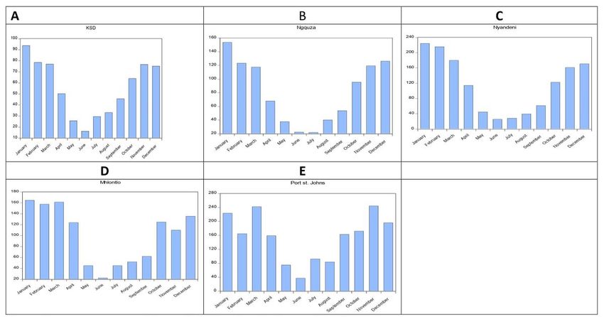
development (Gilmore 2017). Drought negatively impact agricultural production thereby affecting the four
dimensions of food security that is availability, stability, access and utilization (Cheeseman 2016).
Studies from many developing countries strongly concur that rural economic growth and wide-spread
poverty reduction require increased production in agriculture (McGlade et al. 2019). Many concur that
droughts negatively impact agricultural production and efforts to reduce poverty (Udmale 2014).

South Africa is a naturally dry country that is highly vulnerable to droughts and also a major producer of
agricultural goods in Southern Africa (kelly et al. 2015). It is self-sufficient in a range of food commodities
and usually produces exportable surpluses (Gilmore 2017). Southern African countries, such as Namibia,
Botswana, Zimbabwe, Lesotho, Zambia and Mozambique significantly rely on agricultural imports from
South Africa. Droughts has multiple effects on agriculture ranging from crop losses, lower yields in crop
and livestock production, increased livestock deaths, increases in insect infestation and plant and animal
diseases, damage to fish habitat, forest and range fires, land degradation and soil erosion (Pimentel et al.
2014). Furthermore, there is a compelling body of knowledge that link droughts to other epidemics like
famine, diseases and land degradation globally (Adams 2014). Adams (2014) further stated that drought
impact on human health through increased risk of food and water shortages, increased risk of
malnutrition and higher risk of water and food borne diseases. Thus drought represents a constant threat
to health, food security and livelihoods (Davies 2016). Despite being a major regional player in
agriculture, droughts are regular and recurrent in South Africa (Davis and Vincent 2017). Droughts have a
recurrent characteristic feature; and this is especially the case for South Africa because of its highly
variable climate (Tauma et al. 2015).

South Africa's annual average rainfall is approximately 450 mm and that makes the country prone to
recurrent droughts (Hirooka et al. 2019). Drought periods can be characterized from a few hours (short-
term) to millennia (long-term) and there are four categories namely meteorological drought, hydrological
drought, agricultural drought and socio-economic drought (Botai et al. 2016). The effects of drought are
not uniform with regard to time and place as their nature is indicated by precipitation, temperature,
stream flow, groundwater and reservoir levels, soil moisture and snowpack (Francis 2017). In addition,
droughts are triggered by different factors and so is their frequency and intensity. One school of thought
argued that some of the problems caused by drought are difficult to avoid while some are avoidable
through proper planning and effective drought responses (Staupe- Delgado and Kruke 2017). Thus the
need for comprehensive information aided by a comprehensive research that seeks to provide baseline
information on drought cannot be overemphasized (Mwangi 2016). There is very little documentation on
the incidences of drought in South Africa at national level and its various administrative boundaries that
can aid proper planning. South Africa is likely to experience more frequent and severe droughts in future
(Spinoni et al. 2019). It is highly probable that increased climate volatility will result in increased
frequency and intensity of droughts. However, to date, very little research had been done to profile
droughts in South Africa. Profiling droughts has multiple benefits including identifying the most
vulnerable areas for the purpose of improving monitoring, planning, raising awareness’s and
interventions. This could also help in the delineation of major areas facing drought risk for effective
management plans formulation by government authorities. Therefore, this study aims to establish
                                                   Page 3/20
baseline information on the frequency and intensity of droughts in South Africa. The general intention of
this study is to comprehensively profile all the droughts that occurred in O.R Tambo District Municipality
during the period between 1998 to 2018. The study specifically focuses on computing the frequency,
severity and intensity of the droughts in South Africa’s poorest province, Eastern Cape. This information
could be used in the development of a comprehensive and flexible drought management strategy to
effectively reduce the impact of future droughts.
Study Area
The O.R. Tambo District Municipality (ORTDM) occupies the eastern coastal portion of the Eastern Cape
Province, South Africa. The district lies along the coastline of the Indian Ocean stretching for up to 160km
(Morgan 2017). The District extends over a geographical area of 15,946.84 km² and incorporates five
local municipalities, referred to by Fig. 2.1 below (Morgan 2017). OR Tambo District Municipality lies
between the coordinates of 32°46’31’’ S and 21°23’ 29’’ E (Mlanjeni 2014). O.R Tambo is classified as a
Category C2 municipality, indicating a largely rural character and low urbanization rate. In addition to
agriculture, the other economic sectors are community services, trade, finance, transport, manufacturing
and construction (Null 2018). Its suitable terrain and many river valleys provides irrigable land, abundant
water resources, large tracts of grazing land, suitable pasture species for stock grazing, and large
numbers of stock owned by rural communities (Davies 2014). The District has the richest natural
resources and the most fertile soils and favourable climatic conditions. Agricultural practices are intense
although climate dependent (Thomas 2014). It has diverse vegetation types ranging from grasslands,
thicket, forests and bushveld (Munn 2018). Mlanjeni (2014) notes that drought incidents negatively
impact agricultural production of the O.R Tambo District and contributes to food insecurity. The OR
Tambo District receives plenty of rainfall and increased humidity during summer. Winters are colder
especially inland. The district’s climatic conditions are moderate to high rainfall areas, mainly along its
sub-tropical coast and in pockets of mountainous areas (Narloch and Bangalore 2018). The climatic
conditions of O.R Tambo District are warm, temperate, predominantly frost-free conditions. O.R Tambo
District enjoys a high level of annual sunshine, in summer, temperatures range from 16º to 28º Celsius
while winter temperatures range from 7º to 20º C. Winter months fall between April and August while
summer temperatures are usually highest between November and April (Slattery 1998). The people in the
O.R Tambo District enjoy four seasons of the year namely; summer, winter, spring and autumn and they
are characterised by different weather conditions ranging from hot, to cool, mild, windy and cold.
Materials And Methods
Data used on this study was obtained at South African Weather Services in Pretoria. The study employed
daily, monthly and annually precipitation data gathered from the SAWS for the period 1998 to 2018 and
recorded using both automatic and manual weather stations located across OR Tambo District
Municipality. There are a number of weather stations in the ORTD Municipality. Before 1979, the
municipality had seventeen operating weather stations to assist in weather recording and forecasting.
Page 4/20Advances in technology led to the addition of three automatic weather stations in O.R Tambo District
Municipality. The automatic weather stations are located in Port St Johns and King Sabatha Dalindyebo
municipalities, see figure 1 below. According to Mlanjeni (2014), manual weather stations are not
advanced because they held a majority of disadvantages such as missing data and lacked coherence.
Advances in technology and the introduction of automatic weather stations became an alternative and is
a more reliable solution (Aminew et al. 2019). Table 1 below shows all the weather stations in O.R Tambo
District Municipality, their spatial locations and type categorised into automatic and manual weather
stations.
Table 1
Rainfall weather stations in O.R Tambo District Municipality with GPS co-ordinates
Weather station Latitude Longitude Type of weather station
Mthatha prison 31˚ 34’ 59.46’’ S 28˚ 26’ 24.52’’ E Automatic
Baziya plantation 33˚ 34’ 08.98’’ S 28˚ 26’ 00.61’’ E Manual
Qunu plantation 31˚ 46’ 49.54’’ S 28˚ 37’ 24.81’’E Manual
Langeni plantation 31˚ 29’ 7.61’’ S 28˚ 28’ 51.95’’ E Manual
Libode plantation 31˚ 32’ 4.15’’ S 29˚ I’ 10.33’’ E Manual
Cezu plantation 31˚ 46’ 31.80’’ S 28˚ 43’ 44.86’’E Manual
Ngqeleni prison 31˚ 40’ 12.00’’S 29˚ 1’ 40.80’’ E Manual
Silaka nature reserve 31˚ 39’ 9.50’’ S 29˚ 39’ 9.50’’E Manual
Port St John’s 31˚ 38’ 23.27’’ S 29˚32’ 33.57’’E Automatic
Mhlahlane plantation 31˚ 25’ 15.73’’S 28˚ 32’ 38.53’’E Manual
Ntywenka plantation 31˚ 9’ 49.92’’ S 28˚ 32’ 30.72’’ E Manual
Bele plantation 31˚ 19’ 36.91’’ S 28˚ 40’ 12.28’’E Manual
Lusikisiki prison 31˚ 21’ 58.00’’ S 29˚ 34’ 21.28 E Manual
Xhorha plantation 31˚58’ 15.52’’ S 28˚ 41’ 23.19” E Automatic
Ntsubane forest station 31˚ 24’ 24.72’’ S 29˚ 41’ 48.59’’ E Manual
Mkhambathi Reserve 31˚ 17’ 42.40’’ S 29˚ 58’ 47.57’’ E Manual
Etwa Bos 30˚ 17’ 43.31’’E 29˚ 50’ 17.25’’E Manual
Cengcane Bos 31˚ 00’37.75’’ S 28˚ 45’ 41.57,,E Manual
Source: Google Earth
Page 5/20Figure 1 below shows the map for O.R Tambo District Municipality, the local municipalities and the
weather stations, both automatic and manual weather stations.
Data Analyses
Rainfall data was used to compute average annual precipitation for the period 1998 to 2018 and
determining the areas the normal average precipitation. Standardized Precipitation Index (SPI) was used
to compute drought frequency, severity and intensity to expose the high drought risk areas. Various
indices have been developed to assess the onset, severity, frequency, intensity and end of droughts
(Mahlalela et. al. 2018). The selection and application of these methods is based on the anticipated
objectives, nature of the indicator, local conditions, data availability and data validity (Maza et. al. 2019;
Gqwede 2018; Reta et al. 2019; Gerwin et. al. 2018). This study employed the Standard Precipitation
Index (SPI) because of its popularity and ability to synthesise long term data records of precipitation.
This study’s rainfall data spanned over 20 years (Gerwin et.al. 2018). SPI required only precipitation
values to be computed, using different periods of 1-36 months. A number of studies employed the SPI
and commended the index (Sprecher 2017; Tambo et al., 2017 Fischer et. al. 2018 and Gqwede, 2018). In
addition to being widely recommended, this study’s choice of SPI was also influenced by the nature of the
available data.
In order for the results to be precise, understandable and presentable, Meteorological Drought Monitor
(MDM) software program was used to compute the SPI values for the moving average at 3 months, 6
months and at 12 months (yearly) for all the stations within ORTDM. The yearly SPI was presented
graphically to show the months which ORTDM was vulnerable to droughts throughout the referenced
years of study (1998-2018). The MDM output results generated the frequency, intensity of droughts,
drought durations, including minimum and maximum drought time lags. MDM software was used to
compute both the 3 months SPI moving average (3-SPI) and 6 months SPI moving average (6-SPI). Data
used on this study was obtained at South African Weather Services in Pretoria. Standardized
Precipitation Index (SPI) was used to compute drought frequency, severity and intensity to expose the
high drought risk areas. MDM software was used to compute both the 3 months SPI moving average (3-
SPI) and 6 months SPI moving average (6-SPI).
Interpretation of SPI
Negative SPI values represent rainfall deficit, whereas positive SPI values indicated rainfall surplus. The
intensity of drought was classified according to the magnitude of negative SPI values such that the larger
the negative SPI values were, the more serious the event was (Otkin et al. 2019). Table 2 below is an SPI
interpretation and shows the level of wetness and dryness in the rainfall data of ORTDM. The findings
and results of MDM output were interpreted using the SPI Table and these conformed to the SPI
interpretation table.
Page 6/20Table 2
SPI interpretation table
Interpretation Values
Extremely wet less than 2
Very wet 1.5 to 1.99
Moderately wet 1.0 to 1.49
2.0
Near normal -0.99- 0.99
Moderately dry -1 to 1.49
Severely dry -1.5 to -1.99
Extremely dry Greater than -2
Source: (Otkin et al. 2019)
Data analysis
Data analysis is a process of systematically applying statistical or logic techniques to illustrate,
condense and recap and evaluate data (Thill 2019). In this study, graphs and tables were produced to
portray findings of precipitation data obtained for the period 1998-2018. SPI used Meteorological Drought
Monitor (MDM) software programme to analyse output and drought formulas developed by drought
researchers to compute drought frequency and intensity (Salehnia et. al. 2018). Results and findings were
presented graphically using Microsoft excel and Microsoft word was used to draw tables that presented
the results in order to compare the outcomes across ORTDM. One-way analysis of variance (ANOVA) was
used to compare SPI values and MDM output for all the local municipalities in ORTDM to uncover the
ones that experienced most drought occurrences, level of severity, frequency and intensity and highlight
the most vulnerable areas within ORTDM.
Results And Discussions
This section presents the results of precipitation and Standardised Precipitation Index (SPI) trends in O.R
Tambo District Municipality for the period 1998-2018. The first part of the results is the precipitation
graphs for both monthly average and yearly average precipitation for the 5 local municipalities in the
ORTDM. The second section focuses on the presentation of 3 and 6 months Standardised Precipitation
Index (SPI) results for OR Tambo District Municipality. The results are presented for 17 weather stations
located across all the 5 local municipalities. The SPI values were further analysed to give drought severity
Page 7/20and drought classification information for all the municipalities. Results for drought intensity includes
average drought intensity, maximum drought intensity, average drought duration, maximum drought
duration and most intense drought duration per local municipality. The results also present areas that are
vulnerable to both agricultural and hydrological droughts during the referenced period.
Average monthly Precipitation for ORTD Municipalities
Figure 2A-E below depict the average monthly precipitation for all the five local municipalities in OR
Tambo District Municipality. KSD Municipality received its highest rainfall in summer during the months
December, January and February with an average monthly precipitation was 85.6mm. The average
rainfall in summer was higher than the monthly average precipitation of 70.2mm reported by Mditshwa et
al. (2017) for the same municipality. June is reportedly the driest month in KSD Municipality and the
presented results concur with previous finding by Mahlalela et. al. (2018). KSD Municipality has an
annual average precipitation 68.8mm and this is 1.1 mm less than the annual average precipitation of OR
Tambo District Municipality.
Figure 5.1B depicts the average monthly precipitation patterns of Ngquza Hill for the same period (1998
– 2018). Ngquza Hill also receives most rainfall in December, January and February and has a monthly
average precipitation of 132.7 mm and an average annual precipitation of 76.2mm. Coastal areas along
Indian Ocean are influenced by warm Mozambique current and as a result winters are wetter and warmer
than the areas inland (Thill 2019). Ngquza Hill is a coastal municipality and it is the second of all the
local Municipalities in the ORTDM that received the highest rainfall. Its average annual and average
monthly precipitation was higher than the other 3 local municipalities in ORTDM except Port St John’s
Municipality. The average monthly precipitation for Port St Johns is 88.0mm and 89.9mm the annual
average precipitation. Port St Johns winters are not as dry as the rest of the other local Municipalities in
ORTDM and it receives sufficient rainfall and was not susceptible to hydrological drought. Nyandeni local
Municipality and Mhlontlo’s local Municipality received an average monthly precipitation 65.1mm and
64.1mm and average annual precipitation is 64.9mm and 66.5mm, respectively. They both receive
extremely lower rainfall in winter. Indices used to monitor monthly trends of climate in the Eastern Cape
detected that areas inland are drier and colder than coastal areas (Mahlalela et al. 2018). Mhlontlo local
municipality received reduced precipitation in winter season. Mhlontlo Municipality experience its driest
period in 2014 and the authorities there reported loss of livestock and reduced yields on crop production
(Wambua 2019).
Monthly SPI and drought severity for OR Tambo DM
Agricultural practices in ORTDM are a primary human activity therefore, it is important to compute the 3-
month SPI to reflect short and medium-term moisture conditions that are a basis to agricultural droughts.
The 3 months SPI helped to detect soil moisture, groundwater and reservoir storage (Cammalleri et. al.
2019). When SPI is computed for shorter accumulation periods, in this case 3 months’ period, it is used
Page 8/20as an indicator of reduced soil moisture and this has an important impact on agriculture and crops,
especially during farming seasons. Figure 3A-E below shows the graphical representation of the 3
months SPI values distribution for all the weather station in all the five local municipalities in OR Tambo
District Municipality for the period 1998-2018.
Figure 3A-E illustrates that all the five municipalities are susceptible to droughts of varying magnitude
and frequency and the variation is noticeable in specific areas serviced by different weather stations. The
presented graphs also show incidence of extreme to severe droughts of negative 3 months SPI values
above -2.5. The incidence of both meteorological, hydrological and agricultural droughts in the district
municipality is not peculiar. Despite high negative drought severity figures across all the weather stations,
the presented bell curves reflect higher proportion of near normal and moderately wet conditions. This is
the case for all areas as per their respective weather stations. Altın (2019) and SAWS (2018) reported
similar drought patterns indicating that some parts of the country experience below-normal rainfall at
varying frequency with some areas being drier than others during the same period. These results concur
with a number of previous studies in the Eastern Cape and South Africa in general (Altin 2019). Mhlontlo
Local Municipality is one driest inland Municipalities in ORTDM and experienced multiple droughts
negatively impacting agriculture and water sources between 1998-2018 (Dotse 2019). Overall, OR Tambo
District Municipality is susceptible to droughts of varying intensity and the results of the 3 months SPI
across the entire district municipality confirms this. The SPI drought categories from 1998-2018 of
ORTDM shows that some of the levels of hydrological droughts experienced have the potential to cause
some devastating impact such as shortage of drinking water and reduced crop yields. Droughts
negatively impacts river flows, dam levels, crop yields and animal life (Jimmy et al. 2019). The presented
spatial analyses of drought severity, recurrence nature of droughts and the level of variance across
different areas could be used as a tool for identification of the most drought prone areas and drought
periods and these could assist in resource allocation for drought preparedness.
Weather stations in the same municipalities show significant differences in SPI values. This therefore
implies that the quality of drought data and information could be improved by increasing the density of
weather stations in an area. KSDM has the highest number of weather stations and the different in SPI
values across KSD municipality shows that the same municipality can experience varying degrees of
drought in one period and this should not be generalised per municipality. A similar conclusion was made
by Lucinda et. al. (2019). When conducting a drought related study, it is very important to look into the
weather stations and compare the findings rather than generalising. Some critically affected areas might
be overlooked due to a collective description of areas and results (Forbes and St. Cyr. 2019).
Months moving average SPI for ORTDM (1998-2018)
The following section quantifies the proportion of the time each of the 5 local municipalities in ORTDM
experienced drought of different categories using both 3 and 6 months SPI values. Table 3 and Table 4
shows 3 and 6 months SPI results for all the five local municipalities, respectively. The SPI results have
Page 9/20been tabulated according to drought severity class of moderately dry, severely dry and extremely dry
categories and computed for each municipality.
Table 3
Drought severity class table for ORTDM and all its local municipalities for 3 months SPI since (1998-
2018)
Drought Severity Class KSD PSJ Ngquza Nyandeni Mhlontlo Total %of each
Hill class in ORTDM
% % % %
% %
Moderately Dry 53 21 3 21 33 32.7
Severely Dry 31.6 8.7 10 8.7 14 14.6
Extremely Dry 21.25 6.25 10 6.2 5.4 9.3
Total (%) of all categories 61.2 37 50 37 52 56.5
drought
Source: Author’s computation from MDM software output programme
The summarised results in Table 3 above show the summarised results per municipality. The results
show that all the local municipality in OR Tambo District Municipality experienced droughts of varying
severity at different time proportions. KSD Municipality has the highest probability of experiencing a
drought with a percentage of 61.2%, followed by Mhlontlo, Ngquza Hill and lastly PSJ and Nyandeni with
equal probabilities of 37%. Using the 3 months SPI values and summing up all the drought periods when
the SPI is below -1, ORTDM has a 56.5% chance of experiencing drought. Agriculture in the main
economic activity in ORTDM and October, November and December are the growing months. A more than
50% chance of drought in area has important implications for livelihoods and food security in areas
where agriculture is the main livelihood. The higher incidence of droughts in OR Tambo was also reported
by Bae et al. (2019).
Table 4
Drought severity class table for ORTDM and all its local municipalities for 6 months moving SPI since
(1998-2018)
Page 10/20Drought Severity Class KSD PSJ Ngquza Nyandeni Mhlontlo Total % of each
Hill class in ORTDM
Moderately Dry 53.7% 14 25 20 47.1 40
Severely Dry 24% 7 12.5 8.3 28 22
Extremely Dry 23% 7 8.3 3 31 20
Total (%) of all categories 47.3.2% 28.3 29.5 48 52 62
drought
Source: Author’s computation from MDM software output programme
In addition to results on 3 months SPI drought severity classes presented in Table 3, Table 4 above
presents results of the 6 months SPI for the same municipality. Unlike the 3 months SPI results which
estimated a probability of 56.5% susceptibility to droughts for OR Tambo District Municipality, the 6
months SPI estimated a probability of 62%. Thus the district is likely to experience more cumulative 6
months’ droughts than 3 months’ droughts. These results are in line with a study by Jimmy et al. (2019)
who noted that OR Tambo DM experiences hydrological droughts that intensify into agricultural droughts
in a period of 6 months. These results also confirmed reports documented by the Department of Water
Affairs and Forestry (DWAF) on negative anomalies perceived in ORTDM for both on surface and
subsurface water (Mditshwa et. al. 2017). A report by Bae et al. (2019) highlighted only six agricultural
droughts that occurred in OR Tambo District Municipality and these occurred in 2013, 2014, 2015, 2016
and 2017 (Bae et. al. 2019). However, none of the previous studies presented drought reports according to
drought severity class of moderately dry, severely dry and extremely dry categories. It is important to note
that literature has vast information on droughts in the Eastern Cape and OR Tambo District Municipality
as show by multiple citations above but the existing lacks some level of standardisation that can warrant
comparability across both space and time. This owes to the fact that drought studies lack
standardisation in terms of methodology, classification and scales used a challenge also mentioned by
Masupha and Moeletsi (2017). Widespread adoption and SPI or any methodology that promotes the
calculation of the probability of droughts in any area could not be overemphasised especially for drought
preparedness purposes.
SPI data and analyses characterise droughts in a way that detect both the onset and cessation of
drought incidents, something that other indices are unable to do (Cook 2019). It also determines drought
severity, frequency and intensity of droughts and identify areas of high vulnerability. Information on
average drought intensity and duration is crucial for decision making purposes. Table 5 below presents
Page 11/20minimum and maximum drought intensity, average drought intensity and maximum drought duration for
all the five Local Municipalities in OR Tambo DM.
Table 5
Drought intensity class for ORTD local Municipalities since (1998-2018)
Drought intensity KSD PSJ Ngquza hill Nyandeni Mhlontlo
Class
Average Drought -0.77 -0.99 -0.81 -0.71 -0.62
Intensity
Maximum Drought -2.4 in -1.8 -1.9 -2.8 -3.1
Intensity 2014
June 2014 2015 2014-2015 2014
July May August June
Average Drought 1.61 1.21 1.23 2.43 2.32
Duration (SPI less
than -1.0 for
consecutive months)
Maximum drought 1 month,( 1 month, 1 1month, 2 2 months 2 months
duration may week weeks duration 2weeks
2014- duration ( duration ( May – July duration June
June May to July May 2014- 2014) to September
2014) 2014 July 2014) 2014.
Most intense 3 weeks 5 weeks 7 weeks 8 weeks’ 11weeks
duration (DDI (M) duration duration in duration duration duration (May
(SPI less than -2.0 in 2014 2014 (June (May to July (July 2014 2014 to
for consecutive to June to July 2014) to August 2014
months) 2014 2014) September
2014
Source: Author’s computation
Average drought intensity ranges from -0.62 to -0.99. Ngquza Hill municipality is a coastal municipality.
The 3 months SPI values for Ngquza Hill are in contrast to the known supposition and theory that coastal
areas are wetter than inland areas, (Sotsha, 2013). The SPI detects the onset and end of the drought.
Despite presenting a mean drought intensity that is close to normal all the local municipalities experience
long periods of drought ranging from 30 days to 80 days of consecutive dry days. Mhlontlo local
municipality experienced the longest drought duration of 80 days and all the municipalities experienced
their longest drought duration in 2014. The results of the 2014 SPI further confirm the results by
Mafongoya et al. (2019) who assert that in 2014 the whole African continent experienced its worst
drought in more than 50 years with life threatening and devastating impacts. The two coastal
Page 12/20municipalities, PSJ and Ngquza Hill, have relatively lower average drought duration. The presented
outcome confirms that Nyandeni is the driest municipality as it experiences the maximum intensity and
lengthy drought duration. The results agree with previous studies which asserted that areas inland are
drier than coastal areas as noted by Mackay and Gross (2019) in drought studies conducted in Australia.
In South Africa, the years 2014 and 2015 were drought years and Port St Johns was among local
municipalities in ORTDM that experienced water stress and reported a reduction in water levels in its
water bodies and reduced crop yields in farms (Mantsho 2018).
The SPI results could be provide significant statistics that could be considered for drought monitoring,
drought resources allocation and drought preparedness. When distributing drought relief aid, government
departments and aid agencies should prioritise inland municipalities. In addition, these results are crucial
for agricultural purpose. Accordingly, Nyandeni and Mhlontlo should be highly prioritised when it comes
to agricultural drought intervention strategies such as introduction of drought tolerant plants and
animals. This should be the case especially when agriculture is a key livelihood activity. The maximum
drought duration for Mhlontlo, Nyandeni and KSD in ORTDM shows that these municipalities are
vulnerable and high risk municipalities and the same was echoed by Dotse (2016). The findings of this
study confirmed the hypothesis of this study that ORTDM is susceptible to hydrological droughts and
furthermore, revealed the extent of drought effect, frequency, level of severity and intensity and detailed
the areas of higher vulnerability.
Conclusion
This study analyzed the findings and results of drought incidents that occurred in ORTDM during 1998–
2018. The SPI output assisted in profiling and tabulating the drought incidents of ORTDM since 1998–
2018 identifying the most vulnerable drought areas in ORTDM, areas of high drought intensity and most
severely affected areas in the District. Average monthly precipitation for all the five local municipalities
confirms that ORTDM receives more rainfall in summer than in winter and coastal areas receive high
rainfall than inland municipalities. However, there are similarities in the distributions of yearly
precipitation amongst all the local municipalities. All local municipalities received high precipitation
during summer during the months December, January and February; and low precipitation during winter
months (May, June and July). The findings of this study confirmed the hypothesis of this study that
ORTDM is susceptible to hydrological droughts and furthermore, revealed the extent of drought effect,
frequency, level of severity and intensity and detailed the areas of higher vulnerability. Nyandeni is the
highest drought risk area in ORTDM, followed by, Mhlontlo, King Sabatha Dalindyebo Municipality,
Ngquza Hill and Port St Johns Municipality. Agricultural droughts are experienced in Nyandeni, Mhlontlo
and KSDM; conversely hydrological droughts are experienced in Port St Johns and Ngquza Hill
Municipality. The results could be used as a guide to the allocation of resources for drought relief
purpose in a way that seeks to prioritize drought prone areas and vulnerable municipality. The SPI could
be a useful tool when forecasting and estimating the frequency, duration and intensity of droughts.
However, emphasis should be placed on improving the quality of data as this is key in improving the
Page 13/20quality of its outcome. The generated information could add value in decision making for the Department
of Disaster Management in ORTDM and other relevant stakeholders.
Abbreviations
3-SPI 3 months Standardized Precipitation Index
6-SPI 6 months Standardized Precipitation Index
DD Drought Duration
Df Drought frequency
Di Drought intensity
DM District Municipality
Ds Drought severity
EC Eastern Cape Province
GDP Gross Domestic Product
GIS Geographic Information Systems
KSDLM King Sabatha Dalindyebo Municipality
LM Local Municipality
ORTDM Oliver Tambo District Municipality
PSJLM Port St John’s Local Municipality
SAWS South African weather services
SPEI Standardized Evapotranspiration Index
Declarations
Availability of data and materials
Most of the data used in this study was sourced from the South African Weather Services and all the
available data sources are also described in the main body of manuscript. These data sets are available
from the corresponding author on request.
Page 14/20Competing interests
The authors declare that they have no financial or personal relationships that may have inappropriately
influenced them in writing this article.
Funding
This study was made possible by the funding from South African National Research Foundation (NRF)
and Department of Science and Technology (DST) through Walter Sisulu University’s Risk and
Vulnerability Science Centre.
Authors' contributions
M.N. is a master’s student who conducted the research. S.N. and H.K. were mainly responsible for
technical input, the development and writing of the article. M.D.V.N and A.M were responsible for research
supervision.
Acknowledgements
We would like to acknowledge the South African Weather Services who provided the data used in this
study. This study was made possible by the funding from South African National Research Foundation
(NRF) and Department of Science and Innovation (DSI) through Walter Sisulu University’s Risk and
Vulnerability Science Centre.
References
1. Altın TB, Sarış F, Altın BN (2019) Determination of drought intensity in Seyhan and Ceyhan River
Basins, Turkey, by hydrological drought analysis. Theoretical and Applied Climatology, p.1–13
2. Adams M (2014) "Sustainable Production of Nutritious Food for Humanity: Food as the Nexus
Between Human Health, Environmental Resilience and Social Equity."
3. Alexander DC (2017) Natural disasters. Routledge, London
4. Bates RH (2014) Markets and states in tropical Africa: the political basis of agricultural policies, Univ
of California Press
5. Botai CM, Botai JO, Dlamini LC, Zwane NS, Phaduli E (2016) Characteristics of droughts in South
Africa: a case study of free state and North West Provinces. Water 8(10):439
6. Cammalleri C, Barbosa P, Vogt JV (2019) Analysing the Relationship between Multiple-Timescale SPI
and GRACE Terrestrial Water Storage in the Framework of Drought Monitoring. Water, 11(8), p.1672
Page 15/207. Cheeseman J (2016) Food security in the face of salinity, drought, climate change, and population
growth. Halophytes for Food Security in Dry Lands, Elsevier: 111–123
8. Davies S (2016) Adaptable livelihoods: Coping with food insecurity in the Malian Sahel. Springer,
TOWN
9. Davis CL, Vincent K (2017) Climate risk and vulnerability: A handbook for Southern Africa, CSIR
10. Davies KA (2014) Landowners in colonial Peru, University of Texas Press
11. Dotse LNA (2016) Exploring the relationship between water scarcity on food and nutritional security
in rural households in the Nqgeleni location, Eastern Cape (Doctoral dissertation)
12. Forbes KF, Cyr OS (2019) The Challenge Posed by Space Weather to High-Voltage Electricity Flows:
Evidence From Ontario, Canada, and New York State. USA Space Weather 17(12):1720–1747
13. Gerwin W, Repmann F, Galatsidas S, Vlachaki D, Gounaris N, Baumgarten W, Volkmann C, Keramitzis
D, Kiourtsis F, Freese D (2018) Assessment and quantification of marginal lands for biomass
production in Europe using soil-quality indicators. Soil 4(4):267–290
14. Gqwede II (2018) An assessment of the challenges faced by King Sabata Dalindyebo Local
Municipality in respect of the provision of electricity services, Doctoral Dissertation submitted to
Stellenbosch University
15. Gilmore EA (2017) Introduction to Special Issue: Disciplinary Perspectives on Climate Change and
Conflict. Current Climate Change Reports 3(4):193–199
16. Jimmy R, Govender P, Bencherif H, Moodley M (2019) TREND-RUN model application of surface
temperature and its implications for South African forestry and reforestation using local weather
services data. Reforesta, (7), p.50–72
17. Lucinda M, Baez-Villaneuva OM (2019) Characterizing meteorological droughts in data scare regions
using remote sensing estimates of precipitation. Extreme Hydroclimatic Events and Multivariate
Hazards in a Changing Environment: A Remote Sensing Approach, p.221
18. Mafongoya P, Gubba A, Moodley V, Chapoto D, Kisten L, Phophi M (2019) Climate Change and
Rapidly Evolving Pests and Diseases in Southern Africa. In: New Frontiers in Natural Resources
Management in Africa. Springer, Cham, pp 41–57
19. Mlanjeni NL (2014) Identification and documentation of ethnobiological methods used by rural
farmers to control stalk borers on maize in the Eastern Cape province of South Africa, University of
Fort Hare
20. Morgan J (2017) Australian Tussock Grasslands. Australian Vegetation: 438
21. Mditshwa S, Hendrickse RF (2017) Coega and East London industrial development zones (IDZs): the
financial and socio-economic impact of the Eastern Cape IDZs and their prospects. Public and
Municipal Finance
22. Mantsho SM (2018) Effect of land restitution programme on households' food security in Limpopo
Province of South Africa: a case study of Waterberg District, Doctoral dissertation submitted to the
University of
Page 16/2023. Mackay KD, Gross CL (2019) Climate Change Threatens a Fig-Frugivore Mutualism at its Drier,
Western Range Margin. In Proceedings of the Linnean Society of New South Wales (Vol. 141)
24. Mabogunje A (2015) The development process: A spatial perspective. Routledge, London
25. McCombie J, Thirlwall AP (2016) Economic growth and the balance-of-payments constraint, Springer
26. Mwangi M (2016) Diverse Drought Spatiotemporal Trends, Diverse Etic-Emic Perceptions and
Knowledge: Implications for Adaptive Capacity and Resource Management for Indigenous Maasai-
Pastoralism in the Rangelands of Kenya. Climate 4(2):22
27. Maza A, Gutiérrez-Portilla M, Hierro M, Villaverde J (2019) Internal Migration in Spain: Dealing with
Multilateral Resistance and Nonlinearites. International Migration 57(1):75–93
28. Mahlalela PT, Blamey RC, Reason CJC (2018) Mechanisms behind early winter rainfall variability in
the southwestern Cape, South Africa. Climate Dynamics, p.1–19
29. Munn AA (2018) Climatology. Routledge, London
30. McGlade J, Bankoff G, Abrahams J, Cooper-Knock SJ, Cotecchia F, Desanker P, Erian W, Gencer E,
Gibson L, Girgin S, Hirsch F (2019) Global Assessment Report on Disaster Risk Reduction 2019
31. Narloch U, Bangalore M (2018) "The multifaceted relationship between environmental risks and
poverty: new insights from Vietnam." 23(3), p. 298–327
32. Null J (2018) "The Idyll of the Mediterranean Climate: Where Sun and Fine Wines. Flourish"
Weatherwise 71(1):18–25
33. Otkin JA, Anderson MC, Hain C, Svoboda M, Johnson D, Mueller R, Tadesse T, Wardlow B, Brown J
(2016) Assessing the evolution of soil moisture and vegetation conditions during the 2012 United
States flash drought. Agricultural and forest meteorology. 218:230–42
34. Otkin JA, Zhong Y, Hunt ED, Basara J, Svoboda M, Anderson MC, Hain C (2019) Assessing the
evolution of soil moisture and vegetation conditions during a flash drought–flash recovery sequence
over the South-Central United States. Journal of Hydrometeorology 20(3):549–562
35. Otkin JA et al (2016) Assessing the evolution of soil moisture and vegetation conditions during the
2012 United States flash drought. Agric For Meteorol 218:230–242
36. Otkin JA, Zhong Y, Hunt ED, Basara J, Svoboda M, Anderson MC, Hain C (2019) Assessing the
evolution of soil moisture and vegetation conditions during a flash drought–flash recovery sequence
over the south-central United States. J Hydrometeorol 20(3):549–562
37. Puri J, Aladysheva A, Iversen V, Ghorpade Y, Brück T (2017) Can rigorous impact evaluations improve
humanitarian assistance? Journal of Development Effectiveness 9(4):519–542
38. Sotsha K (2013) Indicators of Household-level Vunerability to Climate Change in Three
Topographically Diverse Rural Villages, Doctoral dissertation submitted to the University of Fort Hare
39. Slattery D (1998) The Australian Alps: Kosciuszko, Alpine and Namadgi National Parks, UNSW Press
40. Salehnia N, Alizadeh A, Sanaeinejad H, Bannayan M, Zarrin A, Hoogenboom G (2017) Estimation of
meteorological drought indices based on AgMERRA precipitation data and station-observed
precipitation data. Journal of Arid Land 9(6):797–809
Page 17/2041. Sprecher (2017) Enhancing resilience to climate shocks through farmer innovation: evidence from
northern Ghana. Reg Environ Change 17(5):1505–1514
42. Thomas K (2014) Shadows in an African Twilight: Game Ranger–Soldier-Hunter, Retrieved from
eBookPartnership.com
43. Thill JC (2019) (ed) Spatial multicriteria decision making and analysis: a geographic information
sciences approach. Routledge, London
44. Tauma SG, Newete SW, Adam E, Dubula B (2015) Field spectroradiometer and simulated
multispectral bands for discriminating invasive species from morphologically similar cohabitant
plants. GIScience Remote Sensing 55(3):417–436
45. Udmale P (2014) Farmers ׳perception of drought impacts, local adaptation and administrative
mitigation measures in Maharashtra State, India. International Journal of Disaster Risk Reduction
10:250–269
46. Wambua RM (2019) Drought Estimation-and-Projection Using Standardized Supply-Demand-Water
Index and Artificial Neural Networks for Upper Tana River Basin in Kenya. International Journal of
Applied Geospatial Research (IJAGR) 10(4):11–27
Figures
Page 18/20Figure 1
Distribution of Weather Stations in O.R Tambo DM Note: The designations employed and the
presentation of the material on this map do not imply the expression of any opinion whatsoever on the
part of Research Square concerning the legal status of any country, territory, city or area or of its
authorities, or concerning the delimitation of its frontiers or boundaries. This map has been provided by
the authors.
Figure 2
A-E Average Monthly Precipitation by District Municipality Source: Author’s computation from data
obtained from SAWS (2018)
Page 19/20Figure 3
A-E 3 Months SPI and drought severity for OR Tambo DM Source: Author’s computation from data
obtained at SAWS (2018)
Page 20/20You can also read