APPLICATION OF MULTI-CRITERIA DECISION MAKING FOR THE SELECTION OF SENSING TOOLS FOR HISTORICAL GRAVESTONES
←
→
Page content transcription
If your browser does not render page correctly, please read the page content below
The International Archives of the Photogrammetry, Remote Sensing and Spatial Information Sciences, Volume XLIII-B2-2020, 2020
XXIV ISPRS Congress (2020 edition)
APPLICATION OF MULTI-CRITERIA DECISION MAKING FOR THE SELECTION OF
SENSING TOOLS FOR HISTORICAL GRAVESTONES
Miroslavas Pavlovskis1, Maria Chizhova2 , John Hindmarch2, Mona Hess2
1 Department of Construction Technology and Management, Faculty of Civil Engineering, Vilnius Gediminas Technical
University, Vilnius, Lithuania - miroslavas.pavlovskis@vgtu.lt
2 University of Bamberg, Institute of Archaeology, Heritage Sciences and Art History, Germany – maria.chizhova@uni-
bamberg.de, john.hindmarch@uni-bamberg.de, mona.hess@uni-bamberg.de
KEY WORDS: photogrammetry, 3D, scanning, Jewish, cemetery, gravestones, inscription, multi-criteria decision making
ABSTRACT:
This paper describes a feasibility study for the digitisation of gravestones, specifically Jewish gravestones, alongside an implementation
of Multi-Criteria Decision Making. MCDM methods are common in other contexts, and have been used to address issues particular to
design, organisation and management of large-scale construction and engineering projects. They are, however, novel in the context of
cultural heritage. This paper will examine the potentials of non-contact sensor technologies (including photogrammetry via Structure
from Motion, structured light scanning and terrestrial laser scanning) to record, model and archive the stones and their inscriptions.
The various methodologies will be assessed against set criteria, specifically speed, resolution, readability and scalability for mass
recording, from MCDM including criteria given by humanities scholars in the field of history, theology and Jewish studies.
1. INTRODUCTION evaluation (conservation, petrography, and typology) of these
stones (Arera-Rütenik et al. 2011). A new three-year initiative to
1.1 Motivation document all Bavarian Jewish graveyards was launched in
December 2019.
The cemetery in Hebrew is called the "House of Eternity" and the
"House of Life", where the dead are to have eternal rest. (IAJGS, The provision of comprehensive remote access to collections of
2020) photographs, transcriptions and searchable databases is ongoing,
There are around 10,000 known Jewish cemetery sites across the but still not nearly complete. The sheer number of Jewish
46 member states of the Council of Europe. Before World War II cemeteries and gravestones makes the documentation and
more than seven million Jews lived in Central and Eastern systematic analysis a huge task. Steps towards mass digitisation
Europe, therefore burial sites and cemeteries are a direct physical (in 3D) and automated extraction of information has hitherto not
evidence of this presence. The inscribed Jewish gravestones are been undertaken on a large scale.
artefacts preserving memories of individuals and families. They
are invaluable repositories of historic information and collective The documentation methods described in this paper are non-
memory, and as such the inventorying of the ephemeral heritage contact optical recording and multi-criteria decision-making.
they contain is desirable for the descendants of Jewish families MCDM methods are common in other contexts, and have been
in both Germany and worldwide, as well as for historians and used to address issues particular to design, organisation and
theological researchers. management of large-scale construction and engineering
Eighty years later, many cemeteries are lost or endangered, but projects. Multiple criteria decision-making methods are formal
are still present in urban or rural areas, and often cared for by mathematical techniques for determining an optimal choice from
volunteer organisations. Multiple worldwide initiatives aim to a set of potential alternatives in situations where those
document and preserve Jewish graveyards and to transcribe their alternatives must be evaluated according to a variety of often
gravestones. The motivation to document Jewish burial sites and conflicting and contradictory criteria.
interments, is driven by the worldwide interest in Jewish ancestry They are, however, novel in the context of cultural heritage. With
and heritage as well as individual’s searches for burial places of thousands of gravestones just in the local area of Franconia/
ancestors and relatives. Current initiatives include Jewish North Bavaria, and hundreds of thousands of stones across
Heritage Europe, JewishGen, European Jewish Cemeteries Germany alone, it is vital that the various technologies are
Initiative (ESJF, since 2015), Lo Tishkach Foundation European assessed carefully and accurately. An aid for an objective
Jewish Cemeteries Initiative, Jewish Epitaphs, and others. assessment and rationale for technical digitisation and recording
of these valuable stone-archives should be given to scholars of
In Germany, the documentation of Jewish Gravestones has been the Jewish studies and epigraphy.
approached in a systematic fashion in publications, for example
in Wuerzburg (Müller, 2011), and recently also through 1.2 Research object
systematic semantic databases, for example epidat ─ Research
Platform for Jewish Epigraphy (Steinheim Institut, 2020). In This project will include multiple cemeteries, but for the purposes
Bavaria, this includes the development of databases (Klemm, of this paper, we will examine the Jewish cemetery in
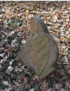
2020). Significant work has been done to systematise the Laudenbach. This 400-year-old cemetery is located in the state of
photography, manual transcription and damage and condition Bavaria, in the south west of Germany. The stones are engraved
This contribution has been peer-reviewed.
https://doi.org/10.5194/isprs-archives-XLIII-B2-2020-1435-2020 | © Authors 2020. CC BY 4.0 License. 1435
The International Archives of the Photogrammetry, Remote Sensing and Spatial Information Sciences, Volume XLIII-B2-2020, 2020
                                               XXIV ISPRS Congress (2020 edition)

with Hebrew and German text, containing not only names and              There are many ways to solve multi-criteria problems. Each
dates of birth but also places of origin, occupations and               method differs in its algorithm and defines various aspects of the
sometimes the entire life stories of the deceased. As such, the         alternatives analysed. A general overview of MCDM methods
stones comprise a rich historical archive for the Jewish                and their application to technological problems is available in
communities throughout the Main Spessart Circle (Alemannia              several research papers (Zavadskas et al., 2016; Zavadskas et al.,
Judaica 2013) (see Fig. 1).                                             2018; Stojčić et al., 2019).
                                                                        As the selection of sensing tools for historical gravestones is
                                                                        described by multiple criteria (see section 4.2), MCDM methods
                                                                        can be applied to find rational solutions for recording and
                                                                        modelling the gravestones.
                                                                        Currently used criteria decision making methods differ according
                                                                        to purpose, solved tasks and complexity. Each method has its
                                                                        own advantages and disadvantages, internal logic, and highlights
                                                                        the different aspect of the object or the situation in question. The
                                                                        best known and most commonly used is the Simple Additive
                                                                        Weighting (SAW) method (Hwang, Yoon 1981; Ginevičius,
                                                                        Podvezko 2008). Our approach, however, will use Weighted
                                                                        Aggregated Sum Product Assessment method with grey numbers
                                                                        (WASPAS-G), originally presented by Zavadskas in 2015
                                                                        (Zavadskas et al 2015), building on his earlier work (Zavadskas
                                                                        et al 2012).
                                                                        In multi-criteria approaches, it is important to determine the
      Figure 1. Jewish cemetery in Laudenbach (Germany)                 weights of criteria. The weight of a criteria is determined by the
                                                                        method of expert estimates, i.e. experts evaluate the alternatives
                                                                        based on experience and knowledge. Each expert's opinion and
Unfortunately, the ‘memory archive’ is at high risk and
                                                                        approach to the assessed criteria may differ, and there may be
preservation of the stones themselves is difficult to impossible.       conflicting opinions. During the ranking stage, the most
The local Buntsandstein (coloured/red sandstone) is soft and            important indicator is given a rank equal to one, the second, two,
readily absorbs moisture meaning the stones suffer from extreme
                                                                        and so on. Expert opinions will be harmonized when the
weathering. In particular, winter frosts can cause catastrophic
                                                                        assessments of all experts are the same, and conversely, expert
damage. The older gravestones are particularly vulnerable. Many         opinions will disagree when assessments are contradictory
of the inscriptions are already irrevocably damaged and their           (Antuchevičienė and Stasiulionis 2012).
valuable historical information lost for good. Many of the
Hebrew inscriptions are already irretrievably lost (Figure 2).
                                                                        2.2 Methods for gravestone digitisation

                                                                        The goal of digital documentation of cemeteries is to create
                                                                        precise topographic maps, indicating the location of specific
                                                                        monuments, gravestones and trees (for orientation), documenting
                                                                        the single gravestone and linking to it personal information about
                                                                        the buried person (name, dates and other inscriptions). In
                                                                        addition, the monuments themselves may be of a cultural value
                                                                        in their typology, shape and craftsmanship.
                                                                        It is necessary to define which aspects of interest are most
                                                                        important for the digitisation tasks, and subsequently, which
                                                                        method and technology would be most efficient for data
                                                                        acquisition. Within the framework of this article, we are focused
Figure 2. Samples of the damaged gravestones in Laudenbach
                                                                        on the documentation of individual gravestones to prepare a
                                                                        future research project for automatic inscription extraction and
                   2. STATE OF THE ART                                  interpretation.
2.1 Multi-Criteria Decision Making (MCDM)
                                                                        The digital cemetery documentation is a challenging task due to
The analysis of different tasks necessary to digitally record the       the large surface areas with many obstacles like vegetation,
gravestones in 3D and analyse the scripts raises the question of        stones and fences to be documented. This task can be
how to make rational decisions regarding quality of the recording       complicated, if the gravestones are affected by erosion due to
versus speed, at the same time as evaluating different alternatives     vegetation, weathering and partial destruction. The campaigns
according to possibly conflicting criteria. Here, a humanities          for digital cemetery documentation have been undertaken in
question, the reading and analysis of inscriptions, can turn to the     many countries around the world (Rütenik et al. 2013; Jones
engineering- and statistical perspective to achieve its goals.          2008; Gabov & Bevan, 2011; Robinson 2018).
Multi-criteria decision-making methods (MCDM) are an                    For the documentation of written information from the
approach to evaluating decisions to select the best option from a       gravestones, 2D images are mostly used. This has been
range of possible alternatives according to various, often              approached by amateur photography, as well as professional or
contradictory, criteria or characteristics. The basis of MCDM           metrological photos acquired with specific sensors (e.g. thermal
methods is that their solution is not always the best according to      IR camera (Heitger 1991), or even a multispectral approach in
every criteria; the result is appropriate when all criteria are taken   (Mathys et al., 2019).
into consideration, but not the best for every (or indeed, any)         (Demir & Yogeswaran, 2018) documented the individual
criterion individually.                                                 gravestones for further geotagging using a smartphone. Here, the
                                                                        text has been automatically recognized using digital image

                                                 This contribution has been peer-reviewed.
                  https://doi.org/10.5194/isprs-archives-XLIII-B2-2020-1435-2020 | © Authors 2020. CC BY 4.0 License.                 1436
The International Archives of the Photogrammetry, Remote Sensing and Spatial Information Sciences, Volume XLIII-B2-2020, 2020
XXIV ISPRS Congress (2020 edition)
processing methods and the Google Tesseract OCR library in a model can be generated with high accuracy (Luhmann et al.,
Python environment. This method is well suited for new, 2019b). A 3D model includes a point cloud or mesh, which could
undamaged gravestones with significant contrast between the be colorized or textured. This method is quite easy to use and
gravestone background and inscriptions. does not require expensive equipment. Nevertheless it is quite
When the gravestones are weathered, destroyed or covered with time consuming.
vegetation they are difficult to decipher. An option is to cover the
stones with a special coating (contrast spray, snow), which helps Structured light scanning
to extract the inscriptions on the monument, but this might be This method is often used to capture complex 3D surfaces by
invasive. However, it is possible to achieve readability with non- projection of a solid speckle pattern or fringe projection on the
invasive digital methods, using 3D optical surface recording of surface (Luhmann et al., 2019b). Due to easy to use sensors with
the geometry. After processing the data, the engraved script can high recording speed, this method is also common in industry
be made readable using artificial lighting. As well, 3D (Wilm, 2016), as well as in cultural heritage documentation
information can be used for the investigation of monument (Kersten et al, 2018). Structured light scanning can be achieved
surfaces or its separate details (e.g. decorations, sculptural with expensive metrology and quality inspection-grade scanners
elements, etc.). (Steinbichler Comet) and more consumer-grade scanners (Artec
Extracting 3D geometry from one image by generating a depth Eva, Spider).
map is not an easy task (Godard et al., 2017; Eigen et al., 2014).
In such cases, other photogrammetric methods could be helpful: It is possible to use drones (SfM) and terrestrial laser scanning
for an overview and simultaneous survey of a large number of
Reflectance Transformation Imaging (RTI) monuments, which, however, will significantly reduce the
RTI has a wide application spectrum within historical surface recording quality of each single gravestone surface and
archaeology (Mytum and Peterson, 2018, Hess et al., 2018; will be hampered by the presence of intervening objects (trees
Piquette 2017). Using basic photographic equipment and special and shrubs, various structures).
reference spheres, an object is recorded from different positions
with light from a known direction. This method allows the 3. METHODS
surface digitalisation with µm accuracy (Coules et al., 2019),
analysation of its microscopic details and visualisation of The methodology for gravestone digitisation is based on the
individual surface features and artefacts (Earl et al., 2010). RTI selection of the most appropriate method in the context of future
has been applied for gravestone digitalisation as well (Gabov & further automatic extraction and interpretation of inscriptions.
Bevan, 2011). The obtained information is in a 2.5D format, In this section, three common 3D recording methods are
what, however, could be enriched with 3D data from compared. These are close-range photogrammetry, structured
photogrammetric approach (Miles et al. 2014) or laser scanning light scanning and terrestrial laser scanning. The methods are
(Díaz-Guardamino & Wheatley, 2013). Generally, the method evaluated by selected criteria and the best method is determined
yields good results and is easily available due to low-cost using MCDM techniques.
equipment and free software. However, it takes a lot of time, To assess the sensor technologies for optical surface recording,
which complicates the work when digitising a large number of we will be applying a MCDM method for ranking alternatives
objects. according to multiple criteria.
Photogrammetry - Structure from Motion 3.1 Data acquisition
The photogrammetric method called Structure from Motion
originates from computer vision (Marr & Poggio, 1976) and has 3.1.1 Photogrammetry/ SfM with consumer camera and
found a wide application in cultural heritage documentation macro lens
(Stylianidis & Remondino, 2016; Vincent et al., 2017; Kersten & An example gravestone represents high-resolution close-range
Lindstaedt, 2012). For data acquisition professional and amateur single stone documentation here from the Jewish cemetery of
photos, video cameras, drones or a combination can be used Zeckendorf, Franconia (see Figure 3).
(Luhmann et al., 2019a). The objects are recorded from different A Nikon D3400 camera was used to take 114 photos with a
positions and viewpoints with high image overlap. After 40mm macro lens. It took about 80 minutes to take all the images
orientation and alignment of images, a photorealistic 3D object from systematic viewpoints in a horizontal and vertical grid over
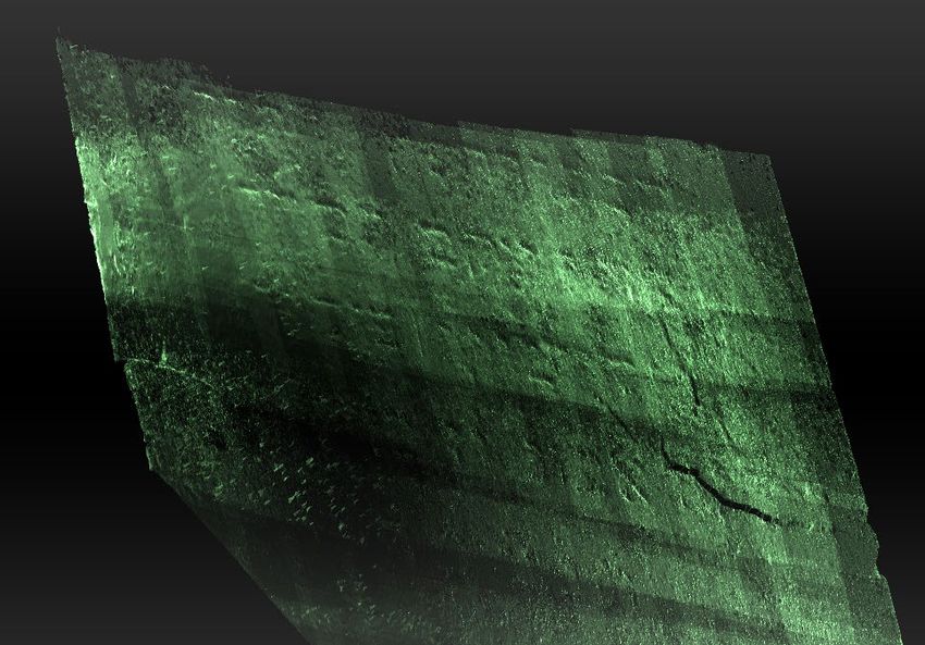
Figure 3. Photogrammetry workflow example for reading faded inscriptions. From left to right: Image of typical gravestone with highly eroded
inscription; 3D model; depth map; output image with readable text.
This contribution has been peer-reviewed.
https://doi.org/10.5194/isprs-archives-XLIII-B2-2020-1435-2020 | © Authors 2020. CC BY 4.0 License. 1437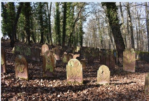
The International Archives of the Photogrammetry, Remote Sensing and Spatial Information Sciences, Volume XLIII-B2-2020, 2020
                                               XXIV ISPRS Congress (2020 edition)

the surface. The ground was uneven, so the levelling of the tripod          •    data acquisition speed (1 million points/sec and 2
and positioning of the camera took longer than expected.                         million points/sec)
For processing a 16GB RAM laptop was used (i7-7500 CPU and                  •    as well as 3D real-time recording rate (7.5 fps and 16
a NVidia Quadro Graphics card with M520 GPU). The timing                         fps).
needed for the single steps of SfM in Agisoft Metashape were:
45 mins alignment, 3 hrs dense cloud, 2.5 hrs for Height field          The accuracy evaluation and data quality from different hand-
mesh, 1 hr for texture. The total processing time took of 7.5           held 3D scanning systems have been presented in Kersten et al,
hours, including other processing steps. Most of the time used          2018 in detail.
was idle, i.e. waiting for the computing to finish. With these          The data was processed with Artec Studio proprietary software
highest computing settings, a dense point cloud of approx. 400m         (see Figure 4 and Figure 5)
points was achieved. Assuming an area of around 2m2 = 200
points per mm2, this resulted in a resolution of between 50 & 100
microns.

3.1.2 Photogrammetry/ SfM with an action camera
Gravestones were also been captured with a low-cost GoPro
camera as video. The GoPro cameras can record photos and
videos. They are characterised by a very wide shooting angle
(170°), which gives the recordings a certain recognition effect.
All devices from Hero5 (2016) onwards have video stabilisation
and voice control (GoPro 2020).
The recorded videos were processed in RealityCapture software
for the photogrammetric 3D reconstruction. In Figure 4 some
samples of gravestones in different materials and colours as well            Figure 5. Pointcloud (Artec Spider) before processing.
their 3D reconstruction (meshes) are shown. As we can see, in
spite of the poor quality the letters are clear visible on the model.
Furthermore, information about the stone (petroglyphic
information and stone quality) and biological growth can be
deducted from the colour images.

3.1.3 Handheld Structured Light Scanning
For the recording of gravestones with Structured Light Scanners
two Artec scanners have been used - Eva and Spider. The
scanners allow the creation of fast, textured and accurate 3D
models of medium sized objects (Artec 2020).
The two scanners are hand-held and differ from each other in
     •    point accuracy (0,05 and 0,1 mm),                                Figure 6. Surface geometry (Artec Spider) after processing.
     •    3D resolution (0,1 and 0,5 mm),
     •    volume capture zone (2,000cm3 and 61,000 cm3)),

                                                                              Figure 7. Handheld scanning handheld structured light
                                                                             scanner with Artec EVA (left) and Artec Spider (right),

                                                                        3.1.4 Terrestrial Laser scanning
                                                                        For terrestrial laser scanning the new BLK360 laser scanner by
                                                                        Leica Geosystems (2018) was used. The BLK360 is a compact
                                                                        imaging laser scanner that uses a 360° laser rangefinder and HD
                                                                        panoramic images. The BLK360 creates coloured 3D point
                                                                        clouds accurate to the millimetre and overlaid with the 2D
                                                                        images. The scans taken by the BLK360 can be registered
                                                                        together to complete the documentation of detailed 3D models of
                                                                        objects in different sizes (1-100 m). LiDAR technology allows
                                                                        capture of 360,000 points per second. Additionally, the scanner
                                                                        is equipped with a thermal imaging camera (Leica Geosystems
  Figure 4. Examples of gravestones captured with GoPro
                                                                        2020). Scan resolution depends on laser beam diameter, optics
 camera (left, stills extracted from video) and processed in
                                                                        and distance to the object.
                    Reality Capture (right).

                                                 This contribution has been peer-reviewed.
                  https://doi.org/10.5194/isprs-archives-XLIII-B2-2020-1435-2020 | © Authors 2020. CC BY 4.0 License.             1438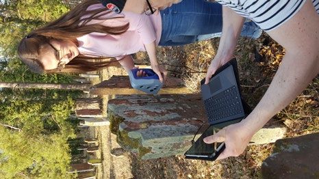
The International Archives of the Photogrammetry, Remote Sensing and Spatial Information Sciences, Volume XLIII-B2-2020, 2020
XXIV ISPRS Congress (2020 edition)
The examples of captured gravestone at a distance of approx. 1m
to the scanner you can see on Figure 8. The data has been ⊗ xˆij = ⊗ xij w j ;
processed in Leica Cyclone Register 360 software. (3)
xˆijα = xijα w j ; xˆijβ = xijα w j
WPM optimality criteria calculation
n
⊗ Si = ∑ ⊗ xˆij , or
j =1
(4)
n
Figure 8. Examples of gravestones captured with BLK 360 laser
⊗ Si = 0.5∑ (xˆijα + xˆijβ ) .
j =1
scanner.
WSM optimization criteria calculation
3.2 WASPAS-G for multiple-criteria decision-making
⊗ Pi = ∏ j =1 ⊗ x
n ⊗wj
Weighted Aggregated Sum Product Assessment method with , or
(5)
( ).
grey numbers (WASPAS-G) is a method, presented in 2015 and
⊗ Pi = ∏ j =1 0.5 ⊗ x jα j + ⊗ x jβ
n ⊗w ⊗w j
applied for the selection of contractors (Zavadskas et al 2015). It
is an extension of an original crisp WASPAS method as
described by Zavadskas et al. in 2012 (Zavadskas et al 2012). The To increase calculation accuracy the aggregation coefficient
method was also used for evaluation of assets redevelopment
solutions (Pavlovskis et al 2016), for selection of most rational
λ = 0,... ,1 determinated:
protective measures preventing falls from elevations
∑
m
(Leonavičiūtė et al. 2016), for building foundation alternatives P
i =1 i
determination (Turskis et al 2016) etc. λ = 0.5 . (6)
∑
m
The WASPAS - G algorithm consists of several steps, where S
i =1 i
⊗ xij to be a grey number with the lower and the upper limit.
Calculation the weighted aggregation of grey optimality
Initial decision-making matrix is then composed of grey numbers
[ ],
functions
⊗ x ij = x ijα , x ijβ where xij are values of alternatives
⊗ Qi = λ ⊗ S i + (1 − λ ) ⊗ Pi =
assessment criteria, i = 1,…, m; j = 1,…, n; m is number of
alternatives, n is number of criteria according to grey system n
(7)
= λ ∑ ⊗ xˆ ij + (1 − λ )∏ j =1 ⊗ x
n ⊗w j
theory (Liu, Lin 2010). ⊗x� ij - the normalized value of the .
criteria; ⊗x� ij - weighted normalized value; ⊗wij-weight of j =1
criteria; Pi- WSM optimization criteria; Si- WPM optimality
An alternative priority line (Alternative Ranking) creating.
criteria.
WASPAS - G algorithm: (Zavadskas et al 2015)
Priority line of alternatives is determined according to the Qi,
• Creating a criteria matrix
after transforming the grey values of ⊗ Qi to crisp values by the
• Criteria matrix normalizing by applying a linear
method. centre-of-area method.
• Criteria with preferred maximal values are suggested
to be normalized as follows: 4. RESULTS
⊗ xij 4.1 Data acquisition results
⊗ xij = ,
max⊗ xij The data acquisition results in terms of 3D recording quality from
i
(1) optical 3D imaging were mostly as expected. The highest
xijα xijβ resolution and including colour-calibrated colour and geometry
i.e. xijα = and xijβ = . resulted from SfM with a macro- lens. Next, in terms of
max xijβ max xijβ
i i resolution and accuracy was the handheld structured-light
scanning, which delivered surface geometry, colour and TIN
• Criteria with preferred minimal values are normalized (mesh). Third ranked was the SfM from action cam video
as: (geometry and colour), followed last by terrestrial laser scanning
(geometry and colour).
min⊗ xij
⊗ xij = i
,
⊗ xij 4.2 Criteria System and experts review (heritage
(2) professionals and surveying experts)
min xijα min xijα
i.e. xijα = i
and xijβ = i
. The selection of the most preferable sensing tools for historical
xijβ xijα gravestones is analysed regarding to a set of criteria. Since this
project is limited in time and resources, we certainly need to
Weighted criteria matrix creating. consider the price of the used tools and the technological criteria.
Also important are the quality criteria that describe the result
obtained.
Considered criteria include:
This contribution has been peer-reviewed.
https://doi.org/10.5194/isprs-archives-XLIII-B2-2020-1435-2020 | © Authors 2020. CC BY 4.0 License. 1439
The International Archives of the Photogrammetry, Remote Sensing and Spatial Information Sciences, Volume XLIII-B2-2020, 2020
                                                XXIV ISPRS Congress (2020 edition)

Alteratives
                                                  Initial criteria values ⊗ xij
    ai                                                                                                                           Ranking results

                  ⊗ x1           ⊗ x2           ⊗ x3           ⊗ x4             ⊗ x5            ⊗ x6            ⊗ x7       Values of functions
                                                                                                                                                   Rank
              a          β   a          β   a          β   a          β     a          β    a          β    a          β    Pi     Si     Qi

    a1        10.0 20.0 10.0 15.0 2.78 3.95 0.1                       1    0.004 0.004 10              10   2          2   0.392 0.439 0.407        2

    a2        5.0    10.0 10.0 20.0 2.75 1.03 0.1                     1    0.002 0.002      9          9    2          2   0.535 0.627 0.565        1

    a3        5.0    15.0 10.0 40.0 22.50 24.50 1.0                   10    4          10   2          2    4          4   0.052 0.276 0.123        5

    a4        5.0    10.0    3.0    10.0 14.50 14.50 0.1          0.1      0.5     0.5      7          7    2          2   0.201 0.443 0.278        4

    a5        5.0    10.0    3.0    10.0 19.80 20.80 0.05 0.05             0.1     0.1      7          7    2          2   0.301 0.539 0.377        3

 Weights                                                                                                                   ∑Pi= ∑Si=    λ=
                  0.176          0.120          0.109          0.191            0.191           0.109           0.104
  ⊗w j                                                                                                                     1.481 2.324 0.319

                                    Table 1. Initial decision-making matrix and rankings in terms of criteria

Technological - economic criteria group:                                          The initial decision-making matrix describes selection of sensing
x1 - Acquisition time/ Data Collection Time (Min).                                tools, as well as ranking results in terms of criteria, applying
x2 - Modelling time/ Processing Time (Min).                                       WASPAS-G method (Eq. 1-7) are presented in Table 1.
x3 - Price of equipment and software (thousands EUR).
Quality criteria group:                                                                                     5. CONCLUSIONS
x4 - 3D point accuracy relative to the real object in the context of
target-performance comparison (mm).                                               The case study results applying WASPAS-G decision-making
x5 - Resolution as pixel pitch size or GSD (mm).                                  method confirmed that the MCDM methods are proved highly
x6 - Score of photorealistic 3D modelling, which could be                         suitable to support selection of the effective sensor for optical 3D
important for the further material investigations (credits between                imaging of gravestones.
1 (very low) and 10 (very high)).
x7 - Variability of raw data, which could be applied separately or                MCDM-calculation results showed that the priority order of
combined for better gravestone investigation and especially                       analysed sensing tools was determined as follows:
automatic text recognition (number of raw data types: colour, 3D                  a2 (0.565, SfM with action camera) > a1 (0.407, SfM with Nikon
coordinates, intensity image, IR etc.)                                            D3400 macro-lens) > a5 (0.377, TLS BLK360) > a4 (0.278,
                                                                                  handheld structured-light scanning Artec Eva) > a5 (0.123,
For criteria x1 – x5, lower values are better, and they are                       handheld structured-light scanning Artec Spider).
minimised in the optimisation process. For the x6 – x7 criteria
higher values are better, and they are maximised. Weights for                     From the all aspects, it was found that the most beneficial is
the criteria were obtained using an expert survey. Since the study                alternative a2 - Photogrammetry with an action camera (Video).
was carried out as part of a project by the ‘Centre for Heritage                  The second ranked alternative is high-resolution close-range
Conservation Studies and Technologies (KDWT)’ at the                              photogrammetry with a consumer camera and macro-lens (a1).
University of Bamberg’s heritage sciences department, the                         Accordingly, from a technical point of view we can state that the
experts interviewed included KDWT employees involved in                           both photogrammetry alternatives are evaluated positively, and
recording and preserving stones at the Jewish cemetery in                         can be successfully used in this projects and similar projects for
Laudenbach, as well as other heritage specialists.                                surface imaging of gravestones. Using this technology is the
                                                                                  optimal ratio of time spent on work, time and quality of the result,
4.3 Calculations                                                                  and the price of equipment is the lowest of those considered.
                                                                                  Structured Light Scanners - Spider (a5) and Eva (a4) are behind
This MCDM-procedure examines the potentials of non-contact                        the best alternative respectively the third and fourth ranked.
sensor technologies to record, model and preserve the stones. In                  Certainly, the usage of the Artec spider requires great patience
the paper five alternatives are evaluated, including high-                        and time and a calm hand over a longer period.
resolution close-range photogrammetry by SfM with a Nikon                         The last ranked is a5 alternative BLK360 Leica Geosystems laser
D3400 and 40mm macro-lens (a1), photogrammetry by SfM with                        scanner, which is designed for terrain and landscape mapping. It
a GoPro action camera (Video)(a2), terrestrial laser scanning with                is also often used for 3D scanning of large architectural objects.
the BLK Leica Geosystems (a3), handheld structured-light                          In this study, the accuracy and resolution delivered BLK360 is
scanning with Artec Eva (a4), handheld structured-light scanning                  not enough, as well as high processing time, and highest price
with Artec Spider (a5).                                                           compared to other alternatives, with respect to high-resolution
                                                                                  recording of the surface. Of course it is a great tool to put the

                                                   This contribution has been peer-reviewed.
                    https://doi.org/10.5194/isprs-archives-XLIII-B2-2020-1435-2020 | © Authors 2020. CC BY 4.0 License.                             1440
The International Archives of the Photogrammetry, Remote Sensing and Spatial Information Sciences, Volume XLIII-B2-2020, 2020
                                               XXIV ISPRS Congress (2020 edition)

gravestones into the topographical context and will provide a         Coules, H.E., Orrock, P.J., Seow, C.E., 2019. Reflectance
geographical mapping of the cemetery.                                 Transformation Imaging as a tool for engineering failure
                                                                      analysis. Engineering Failure Analysis, 105: 1006 – 1017.
The suggested research methodology can be employed in other
case studies for ranking modern technologies and tools to record,     Demir, N., Yogeswaran, N., 2018. Semi-automated cemetery
model and preserve heritage objects.                                  mapping using smartphones. Int. Arch. Photogramm. Remote
                                                                      Sens. Spatial Inf. Sci., XLII-5, 59–62, doi.org/10.5194/isprs-
In this paper, we have described our approach for a technical         archives-XLII-5-59-2018.
solution for fast documentation by 3D surface recording
including assessment of this feasibility study relating to criteria   Díaz-Guardamino, M., Wheatley, D. W., 2013. Rock Art and
for speed and scalability. This is important to be able to record     Digital Technologies: The application of reflectance
hundreds and potentially thousands of stones in Laudenbach            transformation imaging (RTI) and 3D laser scanning to the study
cemetery as well as the many other Jewish cemeteries throughout       of late bronze age Iberian stelae. Journal of Andalusian
the region and indeed, the whole of Germany. This research            prehistory, 3(4): 187 – 203.
provides the basis for further heritage digitisation research
combined with a statistical-engineering approach.                     Earl, G., Martinez, K., Malzbender, T., 2010. Archaeological
                                                                      applications of polynomial texture mapping: analysis,
The aim is to prepare future work, and enable the recording in        conservation and representation. Journal of Archaeological
sufficient resolution towards the transcription of the text,          Science, 37: 2040 – 50.
potentially automating the process using optical character
recognition and machine learning technologies. Another option         Eigen, D., Puhrsch, C., Fergus. R., 2014. Depth map prediction
would be citizen science transcriptions. The usability for content    from a single image using a multi-scale deep network.
specialists – such as Judaists – must still be explored and is a      Proceedings of the 27th International Conference on Neural
future project.                                                       Information Processing Systems, 2: 2366 – 2374.

                  ACKNOWLEDGEMENTS                                    Gabov, A., Bevan, G., 2011. Recording the Weathering of
                                                                      Outdoor Stone Monuments Using Reflectance Transformation
Funding for recording campaigns was delivered by the University       Imaging (RTI): The Case of the Guild of All Arts. Scarborough,
of Bamberg ‘Centre for Heritage Conservation Studies and              Ontario. Journal of the Canadian Association for Conservation,
Technologies’ (Kompetenzzentrum Denkmalwissenschaften und             36: 3 – 14.
Denkmaltechnologien). Great thanks go to Georg Schirmer for
access to Laudenbach Jewish cemetery and coordination and             Ginevičius, R., Podvezko, V., 2008. Daugiakriterinio vertinimo
sustenance during the recording days. Great thanks go to Prof.        būdų suderinamumas, Verslas: teorija ir praktika, 9(1): 73-80.
Dr. Susanne Talabardon, Professorship of Jewish Studies at the
University of Bamberg, an her assistant Dr. Rebekka Denz, who         Godard, C., Mac Aodha, O., Brostow, G.J., 2017. Unsupervised
were instrumental to teach us about the importance of Jewish          Monocular Depth Estimation with Left-Right Consistency. IEEE
graveyards, and to put the topic into the greater context of          Conference on Computer Vision and Pattern Recognition
ongoing research. We are looking forward to further                   (CVPR): 6602 – 6611.
collaboration and projects together.
                                                                      GoPro, 2020. Specifications of GoPro camera. https://gopro.com
                        REFERENCES                                    (5 April 2020).

Alemannia Judaica, 2013. Arbeitsgemeinschaft für die                  Heitger, R.A., 1991. Thermal infrared imaging for the Charity
Erforschung der Geschichte der Juden im süddeutschen und              Hospital Cemetery archaeological survey: implications for
angrenzenden Raum. Der jüdische Friedhof in Laudenbach am             further geological applications. Masters thesis, University of New
Main (Stadt Karlstadt, Landkreis Main-Spessart). URL:                 Orleans.
http://www.alemannia-judaica.de/laudenbach_msp_
friedhof.htm (4 February 2020).                                       Hess, M., MacDonald, L.W., Valach, J., 2018. Application of
                                                                      multi-modal 2D and 3D imaging and analytical techniques to
Antuchevičienė J., Stasiulionis A., 2012. Statybos verslo             document and examine coins on the example of two Roman silver
projektavimas ir investicijos, Technika. ISSN 9786094572456,          denarii. Heritage Science 6, 5. doi.org/10.1186/s40494-018-
190 p.                                                                0169-2.

Arera-Rütenik, T., Cramer, J., Gaisberg, E. von, Kuznicki-            Hwang, C. L., Yoon, K., 1981. Multiple attribute decision
Fischer, S., Horn, T., Tuma, A, , Arnold, I., 2011. Der Jüdische      making – methods and application. Springer-Verlag, Berlin.
Friedhof Weißensee. Inventarisation eines Bau-, Kultur- und
Kunstdenkmalensembles, in: ICOMOS Deutschland (Hg.):                  IAJGS, 2020. Instructions & Information | International Jewish
Jüdische Friedhöfe und Bestattungskultur in Europa.                   Cemetery Project [WWW Document]. IAJGS Cemetery Project.
Internationale Fachtagung, Berlin-Weißensee, 3. - 6. April 2011,      URL https://iajgscemetery.org/instructions/ (5 April 2020).
ICOMOS - Hefte des Deutschen Nationalkomitees 53, 2011, 34-
45.                                                                   Jones, G., 2008. Geophysical mapping of historic cemeteries.
                                                                      Technical Briefs in historical archaeology, 3: 25 – 38.
Artec 3D, 2020. Specification of                  3D    Scanners.
https://www.artec3d.com (5 April 2020).                               Kersten, T. P., Lindstaedt, M., Starosta, D., 2018. Comparative
                                                                      geometrical accuracy investigations of hand-held 3D scanning
                                                                      systems – an update Int. Arch. Photogramm. Remote Sens.
                                                                      Spatial Inf. Sci., XLII-2, 487–494.

                                                This contribution has been peer-reviewed.
                 https://doi.org/10.5194/isprs-archives-XLIII-B2-2020-1435-2020 | © Authors 2020. CC BY 4.0 License.              1441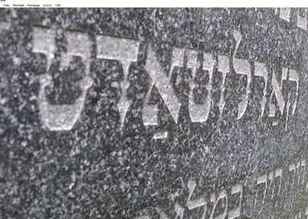
The International Archives of the Photogrammetry, Remote Sensing and Spatial Information Sciences, Volume XLIII-B2-2020, 2020
                                               XXIV ISPRS Congress (2020 edition)

                                                                         University of Central Florida Libraries. Honors Undergraduate
Kersten, T. P., Lindstaedt, M., 2012. Potential of Automatic 3D          Theses. 301.
Object Reconstruction from Multiple Images for Applications in
Architecture, Cultural Heritage and Archaeology. International           Rütenik, T., Horn, T., von Gaisberg, E., Arnold, I., 2013.
Journal of Heritage in the Digital Era, 1(3): 400 – 418.                 Landesdenkmalamt Berlin: 15.628 Berliner: Der jüdische
                                                                         Friedhof Weissensee: Dokumentation der flächendeckenden
Klemm, S., 2020. Jüdischer Friedhof Schopfloch: Bet-Olam.                Erfassung der Grabstätten. Petersberg: Michael Imhof Verlag.
URL:            https://www.juedischer-friedhof-schopfloch.de/
tombstoneList (4 February 2020).                                         Stojčić, M., Zavadskas, E.K., Pamučar, D.,Stević, Ž., Mardani,
                                                                         A., 2019. Application of MCDM Methods in Sustainability
Leica Geosystems 2020. Specifications of BLK 360 laserscanner.           Engineering: A Literature Review 2008–2018. Symmetry, 11,
Avialable at: https://leica-geosystems.com/ products/laser-              350.
scanners/scanners/blk360 (4 February 2020).
                                                                         Turskis, Z., Daniūnas, A., Zavadskas, E. K., & Medzvieckas, J.,
Leonavičiūtė, G., Dėjus, T., Antuchevičienė, J., 2016. Analysis          2016. Multicriteria evaluation of building foundation
and    prevention     of     construction    site    accidents.          alternatives. Computer Aided Civil and Infrastructure
Građevinar, 68(05), 399-410.                                             Engineering, 31(9), 717-729.

Liu, S., Lin, Y., 2010. Grey Systems: Theory and Applications,           Stylianidis, E., Remondino, F., 2016. 3D Recording,
Springer-Verlag, Berlin, Heidelberg.                                     Documentation and Management of Cultural Heritage. Dunbeath
                                                                         Mill: Whittles Publishing.
Luhmann, T., Chizhova, M., Gorkovchuk, D., Hastedt, H.,
Chachava, N., Lekveishvili, N., 2019a. Combination of terrestrial        Vincent, M.L., López-Menchero Bendicho, V.M., Ioannides, M.,
Laserscanning, UAV and close-range photogrammetry for 3D                 Levy, Th.E., 2017. Heritage and Archaeology in the Digital Age.
reconstruction of complex churches in Georgia, Int. Arch.                Acquisition, Curation, and Dissemination of Spatial Cultural
Photogramm. Remote Sens. Spatial Inf. Sci., XLII-2/W11, 753–             Heritage Data. Berlin: Springer, 198.
761.
                                                                         Wilm, J., 2016. Real Time Structured Light and Applications.
Luhmann, T., Robson, S., Kyle, S., Boehm, J., 2019b. Close-              Kgs. Lyngby: Technical University of Denmark. DTU Compute
range photogrammetry and 3D imaging. 3rd ed., Berlin: Walter             PHD-2015, No. 400.
de Gruyter, 822 p.
                                                                         Zavadskas, E. K., Turskis, Z., Antucheviciene, J., 2015. Selecting
Marr, D., Poggio, T., 1976. Cooperative computation of stereo            a contractor by using a novel method for multiple attribute
disparity. Science, 194: 282 – 287.                                      analysis: Weighted Aggregated Sum Product Assessment with
                                                                         grey values (WASPAS-G), Studies in Informatics and Control,
Mathys, A., Jadinon, R., Hallot, P., 2019. Exploiting 3D                 24, 141-150.
multispectral texture for a better feature identification for cultural
heritage, ISPRS Ann. of Photogramm. and Remote Sens. Spatial             Zavadskas, E. K., Turskis, Z., Antucheviciene, J., Zakarevicius,
Inf. Sci., IV-2/W6, 91–97.                                               A., 2012. Optimization of Weighted Aggregated Sum Product
                                                                         Assessment. Electronics and Electrical Engineering =
Miles, J., Pitts, M., Pagi H., Earl, G., 2014. New applications of       Elektronika ir Elektrotechnika,. 122,. 3-6.
photogrammetry and reflectance transformation imaging to an
Easter Island statue. Antiquity, 88(340): 596 – 605.                     Zavadskas, E.K., Govindan, K., Antuchevičienė, J., Turskis, Z.,
                                                                         2016. Hybrid multiple criteria decision-making methods: A
Müller, K., 2011. Die Grabsteine vom jüdischen Friedhof in               review of applications for sustainability issues. Econ. Res.
Würzburg aus der Zeit vor dem Schwarzen Tod:(1147-1346).                 Ekonomska Istraživanja 29, 857–887.
Ges. für Fränkische Geschichte.
                                                                         Zavadskas, E. K., Antucheviciene, J., Vilutiene, T., Adeli, H.,
Steinheim Institut, 2020. epidat ─ Research Platform for Jewish          2018. Sustainable decision-making in civil engineering,
Epigraphy,      URL:        http://www.steinheim-institut.de/cgi-        construction and building technology. Sustainability, 10(1), 14.
bin/epidat?lang=en (4 February 2020).

Mytum, H., Peterson, J. R., 2018. The Application of Reflectance
Transformation Imaging (RTI) in Historical Archaeology. Hist.
Arch., 52: 489 – 503.

Pavlovskis, M., Antucheviciene, J., Migilinskas, D., 2016.
Application of MCDM and BIM for evaluation of asset
redevelopment     solutions. Studies in  Informatics   and
Control, 25(3), 293-302.

Piquette, E.K., 2017. Illuminating the Herculaneum Papyri:
Testing new imaging techniques on unrolled carbonised
manuscript fragments. DCO, 3 (2): 80 – 102.

Robinson, T., 2018. Comparative Headstone Analysis and
Photogrammetry of Cemeteries in Orange County, Florida.

                                                 This contribution has been peer-reviewed.
                  https://doi.org/10.5194/isprs-archives-XLIII-B2-2020-1435-2020 | © Authors 2020. CC BY 4.0 License.                1442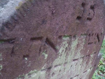
You can also read