Arsenic pollution in Quaternary sediments and water near a former gold mine - Nature
←
→
Page content transcription
If your browser does not render page correctly, please read the page content below
www.nature.com/scientificreports
OPEN Arsenic pollution in Quaternary
sediments and water near a former
gold mine
Łukasz Stachnik*, Bartosz Korabiewski, Jerzy Raczyk, Michał Łopuch & Iwo Wieczorek
Contamination of water and sediments with arsenic and heavy metals is a global issue affecting
human health. Regions covered with Quaternary deposits have received little attention from the point
of view of the flux of arsenic and heavy metals from sediments to surface water. This study aims to
determine the flux of arsenic and other heavy metals from Quaternary sediments to surface waters in
an area affected by the former Złoty Stok gold and arsenic mine. Contamination in surface waters and
sediments was caused by arsenic, whereas concentrations of metals were usually within water quality
standards. Arsenic contamination of surface water increased in the lower part of the basin covered
by Quaternary sediments, and exceeded water quality standards by 2 orders of magnitude. Arsenic
mass flux exceeded 8 kg/day near the confluence of the Trująca River with the Nysa Kłodzka, a main
tributary of the Oder River. An increase in arsenic concentration in the lower part of the basin is related
to mine tailings and preferential flow of groundwater through Quaternary sediments. In future, water
resources scarcity may lead to an increase in arsenic contamination in surface and groundwater.
Contamination of water and soils with arsenic is an issue in over 70 countries and affects more than 140 million
people due to the health risks associated with the consumption of As-contaminated water and food, including
carcinogenic effects and k eratosis1–4. This is usually related to high natural concentrations in groundwater and
anthropogenic activity including mining a ctivity5 and coal c ombustion6. Elevated arsenic concentrations in
groundwater contribute to soil pollution in agricultural areas resulting in the incorporation of arsenic into the
food chain4,7,8.
Dissolution of arsenic-bearing minerals associated with gold mines and their tailings causes an increase in
concentrations of arsenic species in soil and surface water, but the spatial distribution of this pollution is relatively
unknown. Studies have focused on the direct impact of mining activity on soil and water p roperties7, whereas
less emphasis has been placed on soil and water pollution in larger basins. This appears to be especially important
in the case of riverine transport affecting larger areas via solute and sediment-bound yields9,10 and ion exchange
processes11. Moreover, variation in the physiochemical properties of water (e.g. pH, water temperature12,13), mete-
orological conditions ( evaporation12,14,15), suspended sediment and organic matter t ransport14, water residence
time16, groundwater w ithdrawal17, and concentrations of phosphate and iron o xides14,18,19 affect the seasonal
dynamics of arsenic species in surface waters. For example, the summer (as opposed to winter) season, with its
high air and water temperatures, leads to an increase in As mass fluxes12–14. Seasonal changes influencing arsenic
pollution in downstream locations affect water reservoirs, leading to potential human health risks associated with
water consumption7,20.Water pollution also leads to increased bioaccumulation of arsenic by crops, elevating the
risk of food c ontamination8. The development of organic forms of arsenic (e.g. monomethylated and dimethyl-
ated acids) enhances arsenic bioaccumulation21. Assessment of the spatial distribution of arsenic contamination
remains an issue in areas influenced by gold and arsenic mining.
Groundwater flow through Quaternary fluvial and post-glacial deposits usually enhances the release of arse-
nic species, but their relationship with surface water contamination in these areas requires further studies. The
concentration of arsenic species is higher in glacial till than in other types of unconsolidated s ediments22,23. In a
wide variety of Quaternary deposits, the occurrence of intercalated clays and organic carbon results in a higher
rate of release of arsenic species into g roundwater24. For example, palaeochannel deposits consisting of clay and
organic rich sediment facies were characterised by arsenic concentrations nearly an order higher than those in
a sandy aquifer25,26. The long residence time of water in clay-rich Quaternary deposits also facilitates arsenic
release to groundwater27. A gap exists in knowledge concerning the release of arsenic species from Quaternary
aquifers into surface waters.
Department of Physical Geography, Faculty of Earth Sciences and Environmental Management, University of
Wrocław, Wojciecha Cybulskiego 34, Wrocław 50‑205, Poland. *email: Lukasz.Stachnik@gmail.com
Scientific Reports | (2020) 10:18458 | https://doi.org/10.1038/s41598-020-74403-3 1
Vol.:(0123456789)
www.nature.com/scientificreports/
Figure 1. Study area: 1—peak, 2—soil sample, 3—water sample, 4—water gauging station (hydrometric
station), 5—shaft, 6—tailings from mine, 7—tailings from dye-work, 8—sedimentation tank, 9—Sudeten
Marginal Fault, 10—rivers, 11—rivers (2nd order), 12—watershed boundary, 13—watershed boundary
(uncertain), 14—Złoty Stok (town area), 15—major mining areas. Figure generated in ArcMap 10.3 (https://
desktop.arcgis.com/en/arcmap/).
Previous studies in the Złoty Stok area were characterised by their limited focus on the spatial distribution
of arsenic and heavy metal contamination in the lower part of the basin near the confluence of the Trująca River
with the Nysa Kłodzka, a main tributary of the Oder River. Sediments and soils in the vicinity of the town of
Złoty Stok have been intensively studied from the point of view of c ontamination28–30, biological uptake of As
and its remediation31–36, and uptake by h
umans37,38. These studies showed very high levels of arsenic contamina-
tion in alluvial and anthropogenic soils reaching up to 10.3 103 and 43.5 103 mg/kg, respectively28. Surface and
groundwater appear to also be contaminated by arsenic, mercury, and manganese upstream of Złoty S tok39–41.
It is worth noting that the Trująca River may pollute water reservoirs situated on the Nysa Kłodzka River. Even
though the contamination of water and sediments near the former gold and arsenic mine in Złoty Stok is well
known, knowledge concerning the spatial distribution of contamination in the lower part of basin is lacking.
This paper aims to determine the spatial distribution of pollution from arsenic and other metals in surface
waters and Quaternary sediments influenced by the former gold and arsenic mine. Studies dealing with contami-
nation in Quaternary deposits are limited, although water flow conditions in these sediments appear to favour
release of these metals into water. Water contamination downstream of the gold mine exhibits a potential risk
for contamination in higher-order basins such as Nysa Kłodzka. Earlier studies in the Złoty Stok area did not
investigate the contamination of soils and surface water in downstream locations.
Study area
The Trująca (roughly translated as “poisonous”) River basin is located on the border of two physiogeographical
units, the upper part represented by the Złote Mountains, a part of the Eastern Sudetes, and the lower part by
the Otmuchów Depression, a part of the Sudeten F oreland42. These parts are separated by the escarpment of the
Sudetic Marginal Fault (Fig. 1).
The Trująca River flows into Paczkowskie Lake, established on Nysa Kłodzka, a tributary of the Oder River, as
an anti-flood reservoir between 1995 and 2003. The climate is temperate with cold winters and warm summers.
Mean annual air temperature is 8 °C and the sum of precipitation ranges between 600 and 700 mm. Snowfalls
usually occur between September and March and continuous snow cover is observed for 40–60 days a nnually43.
Scientific Reports | (2020) 10:18458 | https://doi.org/10.1038/s41598-020-74403-3 2
Vol:.(1234567890)
www.nature.com/scientificreports/
Figure 2. Geological map of the Trująca River basin: 1—fluvial sand and clay, 2—fluvial sand and pebble, 3—
fluvial sand and pebbles on Pliocene sediments, 4—fluvial pebbles (high terrace), 5—fluvial pebbles on Pliocene
sediments (high terrace), 6—quartzite clay, sand and pebble, 7—clay, 8—schist, 9—gneiss, 10—amphibolite,
11—limestone, 12—mine tailings. Figure generated in ArcMap 10.3 (https://desktop.arcgis.com/en/arcmap/).
Low river discharge is a typical feature during summer heat waves, whereas high discharge occurs as a conse-
quence of snowmelt in spring and intensive rainfall events in a utumn44.
The upper and the lower parts of the Trująca River basin differ significantly in terms of geological settings. The
upper part is mountainous and built mainly of Precambrian metamorphic rocks (mainly blastomylonitic schist
and gneiss) affected by the Skrzynka-Złoty Stok tectonic zone45–47 (Fig. 2). The lower part consists of a valley,
eroded in Quaternary fluvial sands and gravels and filled with alluvium composed of weathered material from the
upper basin. Fluvial units are underlain by impermeable Pliocene silts48. The alpine orogenic phase in the upper
part of the basin upper basin led to the migration of thermal solutions and mineralisation of ore minerals, as
observed mainly in arsenic-bearing minerals such as löllingite ( FeAs2) and arsenopyrite (FeAsS), accompanied
by magnetite, pyrrhotite and p yrite49–51. Secondary arsenic minerals (SAM) consists of Fe arsenates oxidised
under acidic conditions or formed by interactions between acidic As-rich solutions and carbonates (e.g. scorodite
and pitticite). Other SAMs (e.g., erythrite and annabergite) crystallised from slightly acidic to neutral p Hs52.
Gold and arsenic were the most important resources from the Złoty Stok mines and were exploited from the
thirteenth century until the closing of the last mine in 1 96153,54. The landscape of the upper part of the basin
was changed drastically during several hundred years of mining activity. As many as ten large mine tailings are
located on the banks of the Trująca, constituting a possible source of river contamination (Fig. 1). Since 1962,
a dye factory (Złoty Stok Grupa S.A.) has operated in Złoty S tok55, making use of two sedimentary tanks and
wastes stored on the tailings located in the vicinity of the Trująca River (Fig. 1).
Results
SC, pH, and alkalinity increased from the basin head to points downstream of the Trująca River basin. The basin
head was characterised by SC as being below 250 µS/cm, a value which increased twofold in downstream loca-
tions. Groundwater, including the samples from Gertruda and Ochrowa adits (nos 17 and 18, respectively; Fig. 1)
had slightly higher SC values. In downstream sites, the SC of the stream draining the agricultural basin (no. 27)
was the highest compared with other points; however, the small stream (no. 29; Fig. 1) was characterised by much
lower SC, falling below 300 µS/cm (Fig. 3A). Alkalinity generally showed a pattern similar to that of SC, varying
from ca 1–1.5 mmol/L in the head basin to nearly 3.5 mmol/L in downstream locations (Fig. 3C). Nevertheless,
concentrations lower than or similar to that of the main stream were noted for agricultural streams (nos. 27 and
29; Fig. 1). Values of pH changed from circumneutral values of the main river in the head basin (pH 6.9–7.2) to
marginally alkaline values in downstream sites (pH 7.8–8.2; Fig. 3B). The pH of groundwater was similar to that
of the main stream (pH ~ 7.5), but was circumneutral for agricultural streams (Fig. 3B).
Only arsenic concentration showed a clear increase from the head basin to downstream locations, whereas
concentrations of other metals remained stable. In the head basin, the concentration of arsenic in surface waters
did not exceed 1 µmol/L. In downstream locations below the dye factory, there was a pronounced rise in arsenic
Scientific Reports | (2020) 10:18458 | https://doi.org/10.1038/s41598-020-74403-3 3
Vol.:(0123456789)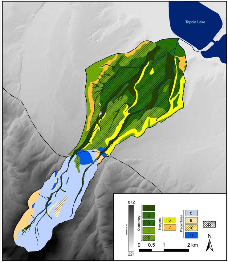
www.nature.com/scientificreports/

                                            Figure 3.  Physiochemical properties of surface and groundwater in the Trująca River (circles) and its
                                            tributaries (rectangles) in 2017 and 2018: (A) water specific conductivity (SC), (B) pH, (C) alkalinity. Detailed
                                            locations of sites are marked in Fig. 1.

          Scientific Reports |   (2020) 10:18458 |               https://doi.org/10.1038/s41598-020-74403-3                                                     4

Vol:.(1234567890)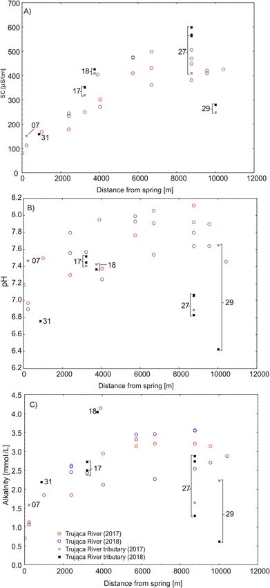
www.nature.com/scientificreports/
Figure 4. Arsenic concentration in surface and groundwater in the Trująca River (circles) and its tributaries
(rectangles) in 2017 and 2018. Detailed locations of sites are marked in Fig. 1.
concentration from 8.5 to 32.9 µmol/L. At the river mouth, arsenic concentration measured 15 µmol/L (Fig. 4).
Concentrations of arsenic were usually higher in groundwater (e.g. no. 17; Fig. 1), exceeding 1 µmol/L, than in
surface waters. In agricultural streams unaffected by the Trująca River (nos. 24 and 27; Fig. 1), arsenic concen-
trations were, on average, below 0.8 µmol/L, but, nevertheless, above water quality standards. Concentrations of
Zn, Fe and Al were stable along the course of the Trująca River and in agricultural streams (Fig. 5) and generally
appeared not to exceed 0.1, 2, and 2 µmol/L, respectively (Fig. 5A–C).
The concentrations of As and heavy metals (Cu, Zn, Pb, Cd, Ni, Cr) exhibited very large differences in profiles
and between transects (Fig. 6). Arsenic-polluted sediments dominated in alluvial deposits, whereas sediments
in the valley slopes were much less polluted. Profiles situated on the valley slopes (nos. A2, A9, B10, C2, D1, D4;
Fig. 1) showed relatively low As content, usually below 160 mg/kg dw, excluding several samples with higher
values (surface samples in D4 and in the middle part of A2). The other profiles represented alluvial deposits in
which As concentrations usually exceeded 1000 mg/kg (nos. A5, B4, B5, D3, D5; Fig. 1), reaching up to 4000 mg/
kg dw locally (nos. C4, C6; Fig. 1).
Sediments on valley slopes were usually characterised by a systematic increase in sand fraction towards
the top of soil profiles. In the sediment fraction the dominant element in the fine earth fraction (< 2.0 mm) was
mainly silt (0.002–0.063 mm). Its average content in alluvial sediment was 65%, in slope sediment 69%. Sedi-
ments in the bottom of the valley were characterised by fraction diversity but were not regular in vertical profiles
(Fig. 7A–D). At the same time, alluvial sediments were characterised by higher contents of sandy fraction. The
clay fraction was on average 4.1% (0.8–7.4%) for all samples, whereas alluvial sediments were characterised by
slightly lower clay contents.
The pHH2O in alluvial sediments increased with the depth of the sediment profile, with the lowest value usu-
ally found in the surface levels enhancing As leaching. A difference between the slopes and alluvial sediments
is also observed. Alluvial sediments usually exhibited a higher pH, ranging from pH 4.8 to 7.0 (on average pH
5.6), compared to sediments on the valley slopes (average pH 4.6, range pH 3.6–6.8).
Discussion
This study provides multidisciplinary data on the distribution of arsenic and heavy metals in Quaternary sedi-
ments and surface waters in a heavily polluted area affected by gold and arsenic mining activity. We show the
relationship between sediment and water contamination in a small catchment of the Trująca River situated in
the upper part of the basin of the Oder, the second largest Polish river.
In the upper part of the basin, concentrations of arsenic and heavy metals (especially Fe, Zn) obtained in
earlier studies were one or more orders of magnitude higher than in our surface and groundwater samples .
For example, arsenic concentrations in the Gertruda adit were higher by a factor of ~ 27 in 1 99656 and ~ 6 in the
2010s41, whereas in the Ochrowa adit, arsenic concentrations were higher by a factor of ~ 180 between 2012 and
201440. Average concentrations of Fe and Zn from 1996 and the 2010s in the Gertruda adit were lower by factors
of ~ 4 and ~ 46, respectively, compared to our results.
Heavy metal and arsenic concentrations in surface waters were usually much lower compared with earlier
studies. In surface waters (nos. 16, 08; Fig. 1), arsenic concentrations in our samples were lower by factors
ranging from ~ 50 to ~ 360 compared with analyses from 199656. In our hydrochemical data, concentrations
of Zn in surface water were approximately 1 to 2 orders of magnitude higher when compared to results from
199656. Only the concentration of Al was higher in surface water in our study compared to earlier studies41,56.
The physiochemical properties of water and metals (As, Fe) concentrations at one site (near the Ochrowa adit,
Fig. 1) according to long-term records from 2011 to 2017 collected by the Voivodeship Inspectorates for Envi-
ronmental Protection in Wrocław (WIOŚ in Wrocław) were similar to those found in data from the upper part
Scientific Reports | (2020) 10:18458 | https://doi.org/10.1038/s41598-020-74403-3 5
Vol.:(0123456789)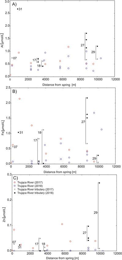
www.nature.com/scientificreports/

                                            Figure 5.  Al, Fe and Zn concentrations in surface and groundwater in the Trująca River (circles) and its
                                            tributaries (rectangles) in 2017 and 2018. Detailed locations of sites are marked in Fig. 1.

          Scientific Reports |   (2020) 10:18458 |              https://doi.org/10.1038/s41598-020-74403-3                                              6

Vol:.(1234567890)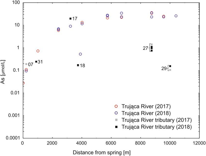
www.nature.com/scientificreports/

                                  Figure 6.  Heavy metals (Cu, Zn, Pb, Cd, Ni, Cr) and arsenic contents in mg/kg in sediments collected from
                                  four transects in the Trująca River basin: (A) transect A (A9, A5, A2); (B) transect B (B10, B5, B4); (C) transect
                                  C (C2, C4, C6); (D) transect D (D1, D3, D4, D5). The position of the sites are shown in Fig. 1.

Scientific Reports |   (2020) 10:18458 |               https://doi.org/10.1038/s41598-020-74403-3                                                      7

                                                                                                                                              Vol.:(0123456789)
www.nature.com/scientificreports/
Figure 7. Granulometric fraction and pH of sediments in the Trująca River basin in the following transects:
(A) transect A (A9, A5, A2); (B) transect B (B10, B5, B4); (C) transect C (C2, C4, C6); (D) transect D (D1, D3,
D4, D5). The position of the sites are shown in Fig. 1.
Scientific Reports | (2020) 10:18458 | https://doi.org/10.1038/s41598-020-74403-3 8
Vol:.(1234567890)www.nature.com/scientificreports/
asin57–63. Concentrations of Zn were lower compared with data from WIOŚ in Wrocław. Decreases in As
of the b
and Zn concentrations from 1990s to 2017–2018 may be attributable to a lowering in aquifer depth, remediation
activities in the mine, or possible differences in the position of sampling points.
The great discrepancy in the concentration of arsenic and heavy metals in the upstream locations appears
to be related to changes in the hydrological regime. Discharge in the Trująca River at sites situated upstream of
the town of Złoty Stok has decreased considerably from 20 L/s and 43–72 in in 1990s56,64 to less than 1 L/s in
November 2018 (Table 2). In 2018, discharge of surface water was equivalent to discharge from springs in the
headwaters of the upper part of the Nysa Kłodzka basin65. Stream flow dominated by baseflow in the Trująca
River basin64 and the falling groundwater table in the Sudetes Mts. in the period 2002–2015 led to reduced surface
water discharge66.The decrease in groundwater flow is evident in the 2018 discharge data and reflects the falling
aquifer level. This leads, in turn, to reduced water content in surface sediments, including polluted sediments,
sludge and mine tailings, which likely inhibits the dissolution of arsenic-bearing minerals and thus the leaching
of arsenic and other metals from groundwater into surface waters. In the Złoty Stok mine, renovation activities,
including the removal of mine tailings and clearing of adits or improvement of mine drainage, also facilitate
reduction of the residence time of water.
Soil contamination downstream. The contents of heavy metals, excluding arsenic, in the majority of soil
samples are below Polish levels defining soil contamination67. Regardless of land-use category, arsenic concen-
tration exceeds the Polish level of soil contamination by up to two orders of magnitude. Most of the profiles (9)
were assigned to soil group III including forests (As > 50 mg/kg), whereas the rest were assigned to arable land
(2) and grassland (2), which belong to group II-2 (As > 20 mg/kg). The content of arsenic in soils between tran-
sect A and the dye factory68 was as high as ~ 1000 mg/kg; this was much lower than our results, which showed
a systematic increase from ~ 1400 mg/kg (e.g. nos. A5, B5; Fig. 1) to ~ 3000 mg/kg in downstream locations of
the Trująca River valley (e.g. nos. C6, C4; Fig. 1); (Fig. 6). Similar and higher values (> 6000 mg/kg) were also
observed in soil samples collected between transects A and B 28,30.
Mobile arsenic species, non-specifically (extracted by 0.05 M ( NH4)2SO4) and specifically (extracted by 0.05 M
NH4H2PO4) sorbed, constitute for less than ~ 2%, and 20%, respectively for alluvial soils situated between tran-
sects A and B28,69. Less mobile arsenic species bonded to amorphous and poorly-crystalline Al and Fe oxides
exceed 30% of total As and are usually higher than poorly bioavailable As bond to well crystallized Fe and Al
oxides28,69. Previous studies also show the significant impact of changing redox conditions on arsenic mobilisation
due to Fe and Mn reduction and reductive d issolution38. In acidic (pH < 5.0) conditions and anaerobic experi-
ments at initial alkaline pH (pH = 8.0) As solubility increases leading to As release in alluvial soil28. Although
anaerobic conditions may develop in the lower part of the Trująca River basin due to boggy terrain (transects C
and D; Fig. 1), pH values, usually below 6.0 inhibit As release. On the other hand, at a downstream location at the
Trująca Valley bottom (points D3, D4, C4), species characterised by acidic soil pH also favour the release of As
into pore water and streams (Figs. 6C,D; 7C,D). As leaching from As-bearing Fe and Mn oxides likely depends
on the activity of autochthonous bacteria, either As-resistant or dissimilatory-As(V) r educing70.
Arsenic content varies greatly in vertical sediment profiles. In general, most of the profiles show reduced As
content at the surface level and increased content in the middle or bottom of the sediment profile. This tendency
was observed both in heavily polluted sediments at the bottom of the valley and the less polluted slopes making
it difficult to distinguish a single factor affecting the distribution of sediment contamination. This great variation
may result from marked anthropogenic transformation including changes in the course of the river, embankment
construction at the valley bottom, and agricultural activity (e.g. fields of crops) on the valley slopes.
Water contamination downstream. The chemistry of surface waters and the physiochemical proper-
ties of water in the lower part of the Trująca River basin are similar to those in studies carried out in 2010–2017
by the Wrocław WIOŚ. In the lower part of the basin, where arsenic concentration reached its highest values
(Table 1, Fig. 4), the initial data on metal concentrations were obtained for one point in 2017 by the Wrocław
WIOŚ (near no. 18; Fig. 1) were similar to our results63. Moreover, the physiochemical properties of water (pH,
SC) from our study were comparable with multi-annual data from the Wrocław WIOŚ57–63.
In the lower part of the basin, arsenic concentrations increased along the Trująca River posing a potential
risk for water quality in the upper part of the Nysa Kłodzka basin. Our results show arsenic concentrations two
orders of magnitude in excess, of water quality standards for potable water (0.1 µmol/L71) and protection of
aquatic life (0.07 µmol/L72,73); (Fig. 4, Table 2). These elevated concentrations were mainly observed in the lower
part of the basin at the confluence of the Trująca River and Paczkowskie Reservoir situated on the Nysa Kłodzka
River, a left tributary of the Oder River. Lack of regular monitoring of metal concentration in the Nysa Kłodzka
downstream of the confluence with the Trująca River makes it difficult to determine the spatial distribution
of arsenic water contamination. Arsenic concentration potentially increased at least fourfold from the Topola
Reservoir (< 0.03 µmol/L in 2 01258) to the Otmuchów (0.16 µmol/L in 2 01574) and Nysa (0.13 µmol/L in 2 01574)
Reservoirs situated ~ 11 and ~ 22 km, respectively, downstream of the junction of the Trująca and Nysa Kłodzka
Rivers (Fig. 1). Moreover, arsenic concentration in the Trująca River appears to be much higher compared with
others small rivers (below 0.02 µmol/L) in the Sudetes Mts.75.
Mechanisms of arsenic release. Mechanisms of arsenic release vary, from reductive dissolution or sul-
phide oxidation in the groundwater in the upper part of the basin to alkali desorption in the lower part of
the basin. Groundwater in mine adits was characterised by very high concentration of reduced As species (As
(III)41), high concentrations of other metals (e.g. Fe, M
n56; Table 1, Fig. 5), and high alkalinity (Fig. 3). These
conditions suggest two processes of arsenic release including reductive dissolution or sulphide oxidation2,23.
Scientific Reports | (2020) 10:18458 | https://doi.org/10.1038/s41598-020-74403-3 9
Vol.:(0123456789)www.nature.com/scientificreports/
Site Parameter SC pH Alk As Fe Al Zn
Mean 195 7.24 2.1 3.2 0.55 0.65 0.0145
Upper Median 174 7.48 2.0 0.6 0.33 0.46 0.0016
Min–Max 81–406 6.76–7.95 0.7–4.1 0–9.3 0–2.15 0.07–2.67 0–0.084
Mean 372 7.43 3.1 12.3 0.42 0.60 0.0128
Mine Median 353 7.43 2.7 19.9 0.09 0.62 0.0001
Min–Max 320–427 7.37–7.52 2.4–4.1 0.2–21 0.02–1.12 0.42–0.71 0–0.0495
Mean 420 7.68 3.0 26.0 0.47 0.60 0.0164
Lower Median 426 7.80 3.1 25.4 0.34 0.52 0.0048
Min–Max 272–506 7.25–8.12 2.1–3.6 11.7–36 0.05–1.68 0.24–1.18 0–0.106
Mean 445 6.85 1.9 0.76 1.05 1.15 0.0867
AG Median 487.5 6.97 1.9 0.87 1.09 1.17 0.0513
Min–Max 249–598 6.43–7.65 0.6–2.9 0.1–1.4 0.05–2.17 0.68–1.71 0.0103–0.2681
Table 1. Specific conductivity (SC, in µS/cm), alkalinity (mmol/L), pH, and heavy metal concentration in
µmol/L in water collected in the Trująca River basin. The following sites were sampled: the upper part of the
Trująca River (nos. 00, 03, 07, 08, 15, 31, 33, 34), the mine (17, 18), the lower part of the Trująca River (20, 21,
22, 24, 28, 32) and agricultural streams (AG) in the lower part outside the Trująca River (27, 29). The position
of the sites are shown in Fig. 1 AG agricultural streams, Alk. Alkalinity.
Site Description Q [L/s] Daily mass flux of As [kg/day]
15 Upper part 0.9 0.04
21 Lower part 31.8 5.76
24 Lower part 35.4 8.25
27 Lower part (agricultural streams) 12.7 0.08
Table 2. Discharge and As mass flux in selected sites in the Trująca River basin in 2018. The position of the
sites are shown in Fig. 1.
Both processes mediated by the microbes were noted in the in close proximity to each other on microbial mats
in the Gertruda adit41. Dissolution of crystalline limestone mineralised with arsenopyrite and pyrite drives water
pH towards neutral values76 suggesting that reductive dissolution appears to be widespread in mine water. On
the other hand, downstream changes in arsenic release mechanisms were observed in surface waters, where As
concentration rose gradually in spite of stronger oxidation related to prolonged contact with the atmosphere57–63.
Alkali desorption, a mechanism for the release of oxidised arsenic species (e.g. As(V)) from iron hydroxyoxides
and clays77,78, may be responsible for arsenic release in surface water79. Despite water pH slightly lower than opti-
mal for alkali desorption (pH > 8.078), the elevated concentration of phosphate (~ 70 µM) in surface water57,59,61
likely shift alkali desorption towards a slightly lower p H78,80,81. Moreover, the mean and median annual pH of
surface water for 2011, 2013, 2015 and 2017 (near site no. 27) was ~ 8.2, within a range from 7.8 to 8.857,59,61,63,
suggesting that alkali desorption is possible. The occurrence of alkali dissolution in the lower part of the basin
suggests that arsenic release increases with increasing phosphate concentration and water pH above 8.0.
The arsenic contamination of the Trująca River not only affects the basin and its surroundings but also exerts
a regional impact on water chemistry. Water quality in the Trująca River is among the poorest in the Lower Silesia
Voivodeship due to arsenic contamination82. However, it is difficult to quantify the impact on water quality and
sediment geochemistry in the downstream reservoirs (e.g. Paczkowski, Otmuchów) on the Nysa Kłodzka River
directly affected by the Trująca River. It is noteworthy that dissolved arsenic mass flux appears to be as high as
8 kg/day during the low discharge conditions observed in November 2018 (Table 2). During snow melt or extreme
rainfall river discharge and suspended sediment reach peak values in the Nysa Kłodzka River83,84, increasing the
potential for elevated arsenic mass flux, in both dissolved and sediment-bound f orms9,21,85. Particularly, sediments
contaminated with arsenic (> 1000 mg/kg; Fig. 6) originating from the erosion of crop areas in the lower part of
the Trująca River basin likely enhances the total mass flux of arsenic.
Regional importance of arsenic contamination. The increase in water scarcity caused by droughts
may result in greater domestic use of As-contaminated water from the Trująca River basin. In nineteenth and
at the beginning of the twentieth century, inhabitants of Złoty Stok and the vicinity developed a wide range of
detrimental health conditions, known as Złoty Stok disease (in German Reichensteiner Krankheit), caused by
drinking As-contaminated water from the Trująca R iver86. These conditions, including dyspepsia, obstipation,
nervousness, browning of the skin, and hyperkeratosis, developed until a pipeline was constructed in 1928 to
supply less-contaminated water from another part of the Złote Mts86. Nowadays, water is mainly supplied via
waterworks from the upper part of the basin near Jawornik Wielki (Fig. 1)87 with an additional water pipe (since
Scientific Reports | (2020) 10:18458 | https://doi.org/10.1038/s41598-020-74403-3 10
Vol:.(1234567890)www.nature.com/scientificreports/
1978) from Kamieniec Ząbkowicki situated 9 km north of Złoty S tok88. The former supplies the town with water
during the part of the season characterised by high water demand for example during low groundwater levels.
Furthermore, increased water scarcity, as shown by a discharge decrease in the Trująca River (Table 2) or an
overall drop in Sudetes spring discharge65,66, likely results in water rationing in Złoty Stok. Additional use of As-
contaminated groundwater from public and private wells in Złoty Stok area may be required to meet long-term
water needs. This process may be occurring in allotment gardens in Złoty Stok, where the soil is characterised
by a very high level of As contamination37, likely due to the use domestic wells88 to water plants. Furthermore,
enhanced evaporation and microbial activity, as a result of higher air temperatures, facilitate increases in As
concentration in surface w ater12,13 and increase groundwater c ontamination17. Both processes, causing water
scarcity, domestic use of water and a reduction in groundwater resources, lead to higher health risks for the
inhabitants of the Złoty Stok area due to contamination of water with As.
A high level of contamination of sediment with As in the lower part of the basin suggests the bioaccumulation
of this element in croplands, leading to the introduction of high concentrations of As into the food web. Fertili-
sation in croplands via phosphate and sewage sludge enhance the mobility of As species in soils89,90. The valley
bottom is characterised by pronounced contamination with As at great distances from the mine (D3, D5, Fig. 6).
Consequently, in croplands, bioaccumulation of As in plant shoots and roots of dry fodder has been found to
exceed permissible content levels for animal f eed91,92. Moreover, As content (72–451 mg/kg) in soils in allotment
gardens suppling inhabitants of Złoty Stok with fruits and vegetables markedly exceeds soil quality l imits37. High
levels of bioaccumulation over a wide range of crops may affect the inclusion As in food consumed by inhabitants
and domestic animals15. Additionally, in forested areas surrounding croplands, decomposition of forest litter leads
to an increased share of highly mobile As species93,94 increasing their transfer to the surrounding arable lands.
A reduction in water resources and human activity in croplands likely leads to a higher risk to human health
in the future. In the town of Złoty Stok, the total 5-year number of new cancer incidents per 1000 people (12–22)
was rather low as compared with the other gminas in the county of Ząbkowice Śląskie in 1986–2015 (Supple-
mentary Figure S1). This number was similar to small villages situated outside As mining sites (e.g. Ciepłowody,
Stoszowice) and was lower by a factor of ~ 2 than in towns in the county (e.g. Kamieniec Ząbkowicki, Ząbkowice
Śląskie) (Supplementary Figure S1). High levels of water and sediment contamination will likely increase in
future, in association with droughts and increase in cropland areas. For example, arsenic water contamination
in the lower part of the basin in Trująca River and agricultural streams exceeds low to moderate concentrations
(10–150 µg/L), at such concentrations, higher risks of diseases such as cancers, cardiovascular diseases, respira-
tion problems, and diabetes mellitus were noted95–98. Consequently, the risk of cancer will likely increase due to
higher consumption of polluted surface and groundwater and crops with high As bioaccumulation.
Future work in the vicinity of Złoty Stok should focus on determining arsenic mass flux in both organic
and inorganic species and the role of soil erosion and water runoff on arsenic transport from the Trująca to the
Nysa Kłodzka River. So far, no analyses of inorganic (As(V), As(III)) or organic arsenic species (associated with
monomethylated and dimethylated acids) have been conducted in the surface water of the Trująca River basin.
Studies on bioavailable arsenic in soils and its potential release are limited to the immediate vicinity of Złoty
Stok and the former gold m ine28,31,41. Studies in the lower part of the basin are lacking; sequential extraction of
28,99
arsenic species should be conducted at these sites. Moreover, annual monitoring of water discharge should
be performed to determine the mass flux of arsenic species.
In this study we focused on the contamination of surface water and Quaternary sediments in the Trująca
River basin, a headwater of the basin of an Oder tributary, i.e. the Nysa Kłodzka River. We have found that As
contamination in soils and surface water extends over great distances from the former arsenic and gold mine,
producing a negative environmental effect on the upper part of area drained by the Nysa Kłodzka River.
Our study emphasises the high levels of contamination with arsenic species in areas covered by croplands
in the lower part of the Trująca River basin. The processes of arsenic release vary, from reductive dissolution in
the upper part to alkali desorption in the lower part of the basin, leading to the highest arsenic contamination
in the basin, exceeding surface water quality limits by at least two orders of magnitude. Moreover, As contami-
nation of soils and mass flux in surface water (~ 8 kg/day) make this area hazardous in terms of regional-scale
contamination (e.g. croplands in the Nysa Kłodzka River and As accumulation in anti-flood reservoirs therein).
The increased scarcity of water resources has resulted in As contamination in surface water, leading to a greater
supply of this element to groundwater in the lower agricultural part of the basin. Furthermore, high levels of
bioaccumulation in croplands has caused introduction of As into the food web, increasing consumption by
human and domestic animals. This will likely lead to increased health risks (e.g. cancer) in spite of the number of
cancer incidents in Złoty Stok is on average at present. Further studies should be conducted on regional arsenic
contamination of the other basin in the upper part of the Nysa Kłodzka basin as manifested by high levels of
contamination in the Trująca River.
Methods
Water samples were collected from the mine (nos. 17 and 18; Fig. 1), the upper (nos. 00, 03, 07, 08, 15, 31, 33, 34;
Fig. 1) and lower (nos. 20, 21, 22, 24, 28, 32; Fig. 1) parts of the Trująca River, and agricultural streams (nos. 27
and 29; Fig. 1) in the Trująca River basin. The agricultural streams are tributaries of the Trująca River situated
in the lower part of the basin representing contamination outside mine drainage. In total, 38 water samples were
collected in November 2017 and October and November 2018. Sampling in both years was chosen on the basis
of different meteorological conditions including higher annual sum of precipitation in 2017 (851.8 mm) than
in 2018 (710.9 mm) as observed in Lądek Zdrój, town situated 10 km to the south from Złoty S tok100. The water
samples (referred hereafter as filterable fraction) were immediately filtered through a cellulose acetate syringe
Scientific Reports | (2020) 10:18458 | https://doi.org/10.1038/s41598-020-74403-3 11
Vol.:(0123456789)www.nature.com/scientificreports/
filter with a pore size of 0.45 µm101. The filtered samples were transferred to HDPE bottles, acidified (Suprapur
30% HCl, Merck), and stored in darkness at 4 °C.
Quaternary sediments were collected from 13 profiles in November 2017, located along four transects per-
pendicular to the valley axis (Fig. 1). They represent alluvial and slope sediments, both potentially polluted by
material from the mine and mine tailings.
Physiochemical properties of water. In the field, water temperature was analysed using a HI9828 port-
able thermometer (Hanna Instruments). The accuracy and resolution of water temperature measurements were
0.15 and ± 0.01 °C, respectively. Water samples were analysed for physiochemical properties (pH, and specific
conductivity, hereafter SC) in the laboratory of the Department of Physical Geography (University of Wrocław,
Poland) immediately following sampling. Measurements were performed using methodology described in the
USGS manual102. In the laboratory calibration was performed using high-quality pH (pH values of 4.01, 7, and
9.21 Hamilton Company) and SC buffers (100 and 300 µS/cm, Reagecon).
Discharge measurements. In order to determine mass flux of arsenic and other metals, discharge was
determined using the timed volume and float m ethods103. The timed volume method was used for a small stream
in the upper part of the basin (no. 15; Fig. 1) where float methods could not be used. In the timed volume
method, a graduated container was used along with simultaneous time measurements to determine water vol-
ume in the small stream. Measurements were carried out five times and mean discharge was calculated, exclud-
ing minimum and maximal values.
The float method was used for streams with higher discharge situated downstream of Złoty Stok in the lower
part of the Trująca River basin (nos. 21, 24, 27; Fig. 1). The float method uses water velocity and a cross-section
of an area to determine water discharge. Standardised floaters in the regular part of a river channel are used
to determine the surface velocity, which is corrected using a roughness c oefficient104,105. The corrected value is
assumed to be the mean water velocity at that point. Although the float method is not widely used in discharge
measurements, it is relatively easy to use in small ungauged s treams103. This method also is particularly useful
for measuring streams in the vicinity of Złoty Stok, where water depth (usually less than 0.1 m) makes it difficult
to carry out measurements using other methods (e.g. the current meter method).
Laboratory analyses. Water analyses. Measurements of metalloid concentrations in water samples were
carried out using graphite furnace atomic absorption spectrometry (GFAAS) for samples with low metal con-
centrations. Calibration curves were made based on standard solutions (Merck). Measurement errors and RSD%
of certified reference material (TMDA-64.3) were 6% and 5%, 5% and 1%, 5% and 3%, and 0.1% and 3% for
filterable As, Fe, Al and Zn, respectively.
Sediment analyses. Grain-size distribution was determined using a Mastersizer 2000 laser d iffractometer106. A
sediment sample was suspended in a beaker of water with added sodium hexametaphosphate (Calgon). A series
of detectors then measured the intensity of light scattered by the particles in the sample for both wavelengths:
for larger particles, red (632 nm), and for sub-micron particles, blue light (470 nm). A combination of both
wavelength was used to determine sediment fractions ranging from 0.1 to 2000 µm107, and sediment fraction
classification was based on108.
Sediments were dried at 105 ºC for 24 h, then pounded in an agate mortar and sieved to obtain a fraction
less than 1 mm. Weighted quantities (~ 1 g) of sediments were digested in a MARS Xpress American microwave
(CEM Corporation) in Suprapur 60% H NO3. Following dilution in 50 ml of de-ionised water, heavy metals (Zn,
Pb, Cu, Cr, Cd, Ni) were determined via GFAAS using an Avanta Sigma GBC atomic absorption spectrometer
(Scientific Equipment Ltd.)109,110. Standard solutions (Merck) were used for calibration111. Blanks were usually
below detection limits. The analysis of the metals in the certified reference materials (ISE-934) showed both
measurement error and %RSD to be lower than 5%.
The pH(H2O) of sediments was measured using distilled w ater112,113. Approximately 10 g of soil was added
to a 50-ml beaker and mixed with 25 ml of distilled water. After 24 h, the pH was measured using an Elmetron
CX-551 pH-meter.
Data availability
The datasets generated during and/or analysed during the current study are available from the corresponding
author on reasonable request (Lukasz.Stachnik@gmail.com).
Received: 1 April 2020; Accepted: 1 September 2020
References
1. Brammer, H. & Ravenscroft, P. Arsenic in groundwater: A threat to sustainable agriculture in South and South-east Asia. Environ.
Int. 35, 647–654 (2009).
2. Ravenscroft, P., Brammer, H. & Richards, K. Arsenic Pollution: A Global Synthesis. (2009).
3. FAO/WHO. Joint FAO/WHO expert committee on food additives JECFA/72/SC. 16 (2010).
4. Scharp, C. et al. Arsenic primer. Guidance on the Investigation and mitigation of arsenic contamination 68 (WHO/UNICEF, 2018).
5. Williams, M. Arsenic in mine waters: An international study. Environ. Geol. 40, 267–278 (2001).
6. Han, F. X. et al. Assessment of global industrial-age anthropogenic arsenic contamination. Naturwissenschaften 90, 395–401
(2003).
Scientific Reports | (2020) 10:18458 | https://doi.org/10.1038/s41598-020-74403-3 12
Vol:.(1234567890)www.nature.com/scientificreports/
7. Ngole-Jeme, V. M. & Fantke, P. Ecological and human health risks associated with abandoned gold mine tailings contaminated
soil. PLoS ONE 12, e0172517. https://doi.org/10.1371/journal.pone.0172517 (2017).
8. Ng, J. C., Ciminelli, V., Gasparon, M. & Caldeira, C. Health risk apportionment of arsenic from multiple exposure pathways in
Paracatu, a gold mining town in Brazil. Sci. Total Environ. 673, 36–43 (2019).
9. Bidone, E. et al. Mass balance of arsenic fluxes in rivers impacted by gold mining activities in Paracatu (Minas Gerais State,
Brazil). Environ. Sci. Pollut. Res. 25, 9085–9100 (2018).
10. Gafur, N. A., Sakakibara, M., Sano, S. & Sera, K. A case study of heavy metal pollution in water of Bone River by Artisanal
Small-Scale Gold Mine Activities in Eastern Part of Gorontalo, Indonesia. Water 10, 1507. https://doi.org/10.3390/w10111507
(2018).
11. DeVore, C. L. et al. Effect of bicarbonate and phosphate on arsenic release from mining-impacted sediments in the Cheyenne
River watershed, South Dakota, USA. Environ. Sci. Processes Impacts 21, 456–468 (2019).
12. McLaren, S. J. & Kim, N. D. Evidence for a seasonal fluctuation of arsenic in New Zealand’s longest river and the effect of treat-
ment on concentrations in drinking water. Environ. Pollut. 90, 67–73 (1995).
13. Masson, M., Schäfer, J., Blanc, G. & Pierre, A. Seasonal variations and annual fluxes of arsenic in the Garonne, Dordogne and
Isle Rivers, France. Sci. Total Environ. 373, 196–207 (2007).
14. Singh, M. et al. Arsenic mobility in fluvial environment of the Ganga Plain, northern India. Environ. Earth Sci. 59, 1703–1715
(2010).
15. Nottebaum, V. et al. Arsenic distribution and pathway scenarios for sediments and water in a peri-urban Mongolian small-scale
coal mining area (Nalaikh District, Ulaanbaatar). Environ. Sci. Pollut. Res. 27, 5845–5863 (2020).
16. Brown, B. V., Valett, H. M. & Schreiber, M. E. Arsenic transport in groundwater, surface water, and the hyporheic zone of a
mine-influenced stream-aquifer system. Water Resour. Res. 43, W11404 (2007).
17. Wallis, I. et al. The river–groundwater interface as a hotspot for arsenic release. Nat. Geosci. 13, 288–295 (2020).
18. Elbaz-Poulichet, F., Seidel, J., Casiot, C. & Vuillemin, M.-H. Short-term variability of dissolved trace element concentrations in
the Marne and Seine Rivers near Paris. Sci. Total Environ. 367, 278–287 (2006).
19. Michel, P. et al. High resolution profiles for arsenic in the Seine Estuary. Seasonal variations and net fluxes to the English Chan-
nel. Cont. Shelf Res. 19, 2041–2061 (1999).
20. Jordaan, M. A. et al. Occurrence and levels of potentially harmful elements (PHEs) in natural waters of the gold mining areas
of the Kette-Batouri region of Eastern Cameroon. Environ. Monit. Assess. 190, 416 (2018).
21. Veloso, R. W., de Mello, J. W. V., Abrahão, W. A. P. & Glasauer, S. Seasonal impacts on arsenic mobility and geochemistry in
streams surrounding a gold mineralization area, Paracatu, Brazil. Appl. Geochem. 109, 104390 (2019).
22. Cook, S. J., Levson, V., Giles, T. R. & Jackaman, W. A comparison of regional lake sediment and till geochemistry surveys: A
case study from the Fawnie Creek area, central British Columbia. Explor. Min. Geol. 4, 93–110 (1995).
23. Smedley, P. L. & Kinniburgh, D. G. A review of the source, behaviour and distribution of arsenic in natural waters. Appl. Geochem.
17, 517–568 (2002).
24. Zhang, H. Arsenic movement and traces in the groundwater from the Hetao area, Inner Mongolia. Environ. Earth Sci. 69,
1579–1588 (2013).
25. Guillot, S. et al. Origin of arsenic in Late Pleistocene to Holocene sediments in the Nawalparasi district (Terai, Nepal). Environ.
Earth Sci. 74, 2571–2593 (2015).
26. Sahu, S. & Saha, D. Role of shallow alluvial stratigraphy and Holocene geomorphology on groundwater arsenic contamination
in the Middle Ganga Plain, India.. Environ. Earth Sci. 73, 3523–3536 (2015).
27. Simsek, C. Assessment of naturally occurring arsenic contamination in the groundwater of Sarkisla Plain (Sivas/Turkey). Environ.
Earth Sci. 68, 691–702 (2013).
28. Krysiak, A. & Karczewska, A. Arsenic extractability in soils in the areas of former arsenic mining and smelting, SW Poland. Sci.
Total Environ. 379, 190–200 (2007).
29. Karczewska, A. & Duszyńska, D. Metale ciężkie i arsen w powierzchniowych poziomach gleb leśnych Złotego Jaru na obszarze
dawnego górnictwa złota i arsenu w Złotym Stoku. Zesz. Probl. Post. Nauk Roln. 520, 101–106 (2007).
30. Karczewska, A. et al. Arsenic distribution in soils of a former As mining area and processing. Pol. J. Environ. Stud. 22, 175–181
(2013).
31. Karczewska, A., Bogda, A. & Krysiak, A.Arsenic in soils in the areas of former mining and mineral processing in Lower Silesia,
southwestern Poland. In Trace Metals and other Contaminants in the Environment, Vol. 9, 411–440 (2007).
32. Antosiewicz, D. M., Escudě-Duran, C., Wierzbowska, E. & Skłodowska, A. Indigenous plant species with the potential for the
phytoremediation of arsenic and metals contaminated soil. Water Air Soil Pollut. 193, 197–210 (2008).
33. Lewińska, K. & Karczewska, A. Suitability of DGT method for assessment of Arsenic bioavailability and its uptake by plants—
tested on the example of Holcus lanatus [Ocena przydatności metody DGT do określenia biodostępności Arsenu i pobrania
przez rośliny – na przykładzie Kłosówki wełnistej (Holcus lanatus)]. Environ. Prot. Nat. Resour. 49, 513–520 (2011).
34. Karczewska, A., Lewińska, K. & Gałka, B. Arsenic extractability and uptake by velvetgrass Holcus lanatus and ryegrass Lolium
perenne in variously treated soils polluted by tailing spills. J. Hazard. Mater. 262, 1014–1021 (2013).
35. Karczewska, A. et al. Solubility of arsenic and its uptake by ryegrass from polluted soils amended with organic matter. J. Geochem.
Explor. 182, 193–200 (2017).
36. Lewińska, K., Karczewska, A., Siepak, M. & Gałka, B. Potential of Fe-Mn wastes produced by a water treatment plant for arsenic
immobilization in contaminated soils. J. Geochem. Explor. 184, 226–231 (2018).
37. Karczewska, A., Lewińska, K., Agata, M. & Krysiak, A. Soil pollution by arsenic within the allotment gardens in Zloty Stok. Ecol.
Chem. Eng. A. 17, 927–933 (2010).
38. Rajpert, L. et al. Arsenic mobilization from historically contaminated mining soils in a continuously operated bioreactor:
Implications for risk assessment. Environ. Sci. Technol. 50, 9124–9132 (2016).
39. Marszałek, H. & Wąsik, M. Some physico-chemical features of water in suprapermaforst zone in the Hornsund region (SW
Spitsbergen). Biul. Państw. Inst. Geol. 456, 397–404 (2013).
40. Mickiewicz, A., Marszałek, H., Cięzkowski, W. & Szumska, E. Złoty Stok—An attempted Sudetic health resort with arsenical
waters. Prz. Geol. 63, 940–943 (2015).
41. Drewniak, L. et al. Physiological and metagenomic analyses of microbial mats involved in self-purification of mine waters
contaminated with heavy metals. Front. Microbiol. 7, 1252 (2016).
42. Solon, J. et al. Physico-geographical mesoregions of poland: Verification and adjustment of boundaries on the basis of contem-
porary spatial data. Geogr. Pol. 91, 143–170 (2018).
43. Głowicki, B., Oton, I., Urban, G. & Tomczyński, K.Klimat in Opracowanie Ekofizjograficzne dla Województwa Dolnośląskiego
53–62 (Wojewódzkie Biuro Urbanistyczne, 2005).
44. Dubicki, A. et al.Wody powierzchniowe in Opracowanie Ekofizjograficzne dla Województwa Dolnośląskiego 79–84 (Wojewódzkie
Biuro Urbanistyczne, 2005).
45. Cwojdziński, S. Szczegółowa Mapa Geologiczna Sudetów, arkusz Złoty Stok 1:25 000. (1974).
46. Cwojdziński, S. Szczegółowa Mapa Geologiczna Sudetów, arkusz Trzebieszowice 1:25 000. (1977).
47. Cwojdziński, S. & Kozdrój, W. The Sudetes geoturist guide. (Polish Geological Institute, 2007).
48. Sawicki, L. (Instytut Geologiczny, Warszawa, 1956).
Scientific Reports | (2020) 10:18458 | https://doi.org/10.1038/s41598-020-74403-3 13
Vol.:(0123456789)www.nature.com/scientificreports/
49. Muszer, A. In Góry Złote - geologia, okruszcowanie ekologia Rychlebské Hory - geologie, zrudnéní, ekologie : materiály vědeckě
konference (ed Muszer A.) 115–118 (Uniwersytet Wrocławski).
50. Niczyporuk, K. & Speczik, S.Gold in arsenic minerals of Zloty Stok area. In Zlote Mts.—Geology, Ore Mineralization, Ecology,
Conference Proceedings 71–77 (Wydawnictwo Uniwersytetu Wroclawskiego, 1995).
51. Muszer, A. Charakterystyka okruszcowania skał północnej i środkowej części Gór Złotych na tle budowy geologicznej.
(Wydawnictwo Uniwersytetu Wrocławskiego, 1997).
52. Siuda, R. & Macioch, A. Secondary arsenic minerals from the Złoty stok As-Au abandoned mine (SW poland). Geol. Q. 62,
925–940 (2018).
53. Muszer, A.Forming of ore mineralization. In Zlote Mts in Zlote Mts.—Geology, Ore Mineralization, Ecology, Conference Proceed-
ings 52–56 (Wydawnictwo Uniwersytetu Wroclawskiego, 1995).
54. Mikoś, T., Salwach, E., Chmura, J. & Tichanowicz, J. Złoty Stok - najstarszy ośrodek górniczo-hutniczy w Polsce. Od wydobycia i
przerobu rud złota i arsenu do zabytkowej kopalni. [Złoty Stok. The oldest mining and smelting centre in Poland. From mining and
processing of gold and arsenic ore, to historic site]. (AGH uczelniane wydawnictwa naukowo-dydaktyczne, 2009).
55. Runkowski, R. Monografia historyczna Zakładów Górniczo-Chemicznych „Polifarb” Złoty Stok. 92 (1982).
56. Marszałek, H. & Wąsik, M. Influence of arsenic-bearing gold deposits on water quality in Zloty Stok mining area (SW Poland).
Environ. Geol. 39, 888–892 (2000).
57. Wrocław WIOŚ. Wody powierzchniowe. Wyniki pomiarów [Surface Waters. Results of measurements], https://www.wroclaw.pios.
gov.pl/index.php?dzial=monitoring&pod=wPow&pod2=opracowania&pod3=wyniki-2011 (2011).
58. Wrocław WIOŚ. Wody powierzchniowe. Wyniki pomiarów [Surface Waters. Results of measurements], https://www.wroclaw.pios.
gov.pl/index.php?dzial=monitoring&pod=wPow&pod2=opracowania&pod3=wyniki-2012 (2012).
59. Wrocław WIOŚ. Wody powierzchniowe. Wyniki pomiarów [Surface Waters. Results of measurements], https://www.wroclaw.pios.
gov.pl/index.php?dzial=monitoring&pod=wPow&pod2=opracowania&pod3=wyniki-2013 (2013).
60. Wrocław WIOŚ. Wody powierzchniowe. Wyniki pomiarów [Surface Waters. Results of measurements], https://www.wroclaw.pios.
gov.pl/index.php?dzial=monitoring&pod=wPow&pod2=opracowania&pod3=wyniki-2014 (2014).
61. Wrocław WIOŚ. Wody powierzchniowe. Wyniki pomiarów [Surface Waters. Result of measurements], https://www.wroclaw.pios.
gov.pl/index.php?dzial=monitoring&pod=wPow&pod2=opracowania&pod3=wyniki-2015 (2015).
62. Wrocław WIOŚ. Wody powierzchniowe. Wyniki pomiarów [Surface Waters. Result of measurements], https://www.wroclaw.pios.
gov.pl/index.php?dzial=monitoring&pod=wPow&pod2=opracowania&pod3=wyniki-2016 (2016).
63. Wrocław WIOŚ. Wody powierzchniowe. Wyniki pomiarów [Surface Waters. Result of measurements], https://www.wroclaw.pios.
gov.pl/pliki/wody_pow/wyniki_badan_jcwp_2017.xlsx (2017).
64. Ciężkowski, W. In Góry Złote-geologia, okruszcowanie ekologia Rychlebské Hory-geologie, zrudnéní, ekologie : materiály vědeckě
konference (ed Muszer A.) 86–87 (Uniwersytet Wrocławski).
65. Buczyński, S. Temporal variability of springs in catchment areas located in the Sudeten Mountains. Hydrol. Res. 49, 780–793
(2017).
66. Staśko, S. & Buczyński, S. Drought and its effects on spring discharge regimes in Poland and Germany during the 2015 drought.
Hydrolog. Sci. J. 63, 741–751 (2018).
67. Rozp. Min. Środ. z dn. 1 września 2016 "w sprawie sposobu prowadzenia oceny zanieczyszczenia powierzchni ziemi", Dz.U. z
dn. 5 września 2016 Poz. 1395 (ed Ministerstwo Środowiska) (2016).
68. Meinhardt, B., Danielska, I., Kubacka, L. & Hanula, P. Ocena stopnia zanieczyszczenia gleb w województwie dolnośląskim w 2016
roku (Wojewódzki Inspektorat Ochrony Środowiska we Wrocławiu, Wrocław, 2016).
69. Gusiatin, Z. M., Klik, B. & Kulikowska, D. Tannic acid for remediation of historically arsenic-contaminated soils. Environ.
Technol. 40, 1050–1061 (2019).
70. Rajpert, L., Schäffer, A. & Lenz, M. Redox-stat bioreactors for elucidating mobilisation mechanisms of trace elements: An example
of As-contaminated mining soils. Appl. Microbiol. Biotechnol. 102, 7635–7641 (2018).
71. Rozp. Min. Zdr. z dn. 13 listopada 2015 "w sprawie jakości wody przeznaczonej do spożycia przez ludzi", Dz.U. z dn. 27 listopada
2015 Poz. 1989 (ed Ministerstwo Zdrowia) (2015).
72. Canadian Council of Ministers of the Environment. (ed Canadian Council of Ministers of the Environment) (Canadian Council
of Ministers of the Environment, Winnipeg, 2001).
73. Canadian Council of Ministers of the Environment.Appendix XXIII—Canadian water quality guidelines: Updates (June 1997),
arsenic, bromacil, carbaryl, chlorpyrifos, deltamethin, and glycols in Canadian water quality guidelines, Canadian Council of
Resource and Environment Ministers 1987 (ed Task Force on Water Quality Guidelines) (1997).
74. Opole WIOŚ. Wyniki badań rzek. [Result of river water investigations], https://www.opole.pios.gov.pl/wms/Pliki/2016/wynik
i_rzek_2015.pdf (2015).
75. Salminen, R. et al. FOREGS Geochemical Atlas of Europe, Part 1: Background Information, Methodology and Maps. (2005).
76. Torres, M. A., West, A. J. & Li, G. Sulphide oxidation and carbonate dissolution as a source of CO2 over geological timescales.
Nature 507, 346–349 (2014).
77. Goldberg, S. Competitive adsorption of arsenate and arsenite on oxides and clay minerals. Soil Sci. Soc. Am. J. 66, 413–421
(2002).
78. Dixit, S. & Hering, J. G. Comparison of Arsenic(V) and Arsenic(III) sorption onto iron oxide minerals: Implications for arsenic
mobility. Environ. Sci. Technol. 37, 4182–4189 (2003).
79. Sultan, K. & Dowling, K. Seasonal changes in arsenic concentrations and hydrogeochemistry of Canadian creek, Ballarat (Vic-
toria, Australia). Water Air Soil Pollut. 169, 355–374 (2006).
80. Violante, A. & Pigna, M. Competitive sorption of arsenate and phosphate on different clay minerals and soils. Soil Sci. Soc. Am.
J. 66, 1788–1796 (2002).
81. Stollenwerk, K. G. et al. Arsenic attenuation by oxidized aquifer sediments in Bangladesh. Sci. Total Environ. 379, 133–150
(2007).
82. WIOŚ in Wrocław. Ocena stanu jednolitych części wód powierzchniowych na terenie województwa dolnośląskiego za rok 2017.
(Wojewódzki Inspektorat Ochrony Środowiska we Wrocławiu, Wrocław, 2018).
83. Zielinski, T. Erosional effects of catastrophic floods in the Nysa Kłodzka drainage basin during the 1997 and 1998 events (SW
Polska). Prz. Geol. 49, 1096–1100 (2001).
84. Jeziorska, J. & Niedzielski, T. Applicability of TOPMODEL in the mountainous catchments in the upper Nysa Kłodzka river
basin (SW Poland). Acta Geophys. 66, 203–222 (2018).
85. Larson, L. N. & Stone, J. J. Sediment-bound Arsenic and Uranium Within the Bowman-Haley Reservoir, North Dakota. Water
Air Soil Pollut. 219, 27–42 (2011).
86. Kathe, J. Das Arsenvorkommen bei Reichenstein und die sog. Reichensteiner Krankenheit, Schlesien Gesellschaft fur vaterlandische
Cultur. 23 (1937).
87. Mickiewicz, A.Aktualny stan rozpoznania hydrogeologicznego obszaru złożowego w Złotym Stoku. In Interdyscyplinarne zagad-
nienia w górnictwie i geologii Vol. IV (ed Drzymała J.) 151–158 (2013).
88. Salwach, E. Kronika Złotego Stoku: Polska Rzeczpospilita Ludowa lata 1945–1989 [Chronicles of Złoty Stok during Polish People’s
Republic 1945–1989] https://zlotystok.salwach.pl/kronika/7 (2020).
Scientific Reports | (2020) 10:18458 | https://doi.org/10.1038/s41598-020-74403-3 14
Vol:.(1234567890)You can also read