Spatio-temporal dynamics of sediment transfer systems in landslide-prone Alpine catchments - Solid Earth
←
→
Page content transcription
If your browser does not render page correctly, please read the page content below
Solid Earth, 10, 1489–1503, 2019
https://doi.org/10.5194/se-10-1489-2019
© Author(s) 2019. This work is distributed under
the Creative Commons Attribution 4.0 License.

Spatio-temporal dynamics of sediment transfer systems in
landslide-prone Alpine catchments
François Clapuyt1 , Veerle Vanacker1 , Marcus Christl2 , Kristof Van Oost1,4 , and Fritz Schlunegger3
1 Earth  and Life Institute, Georges Lemaître Centre for Earth and Climate Research, Université catholique de Louvain,
Place Pasteur, 3 Bte L4.03.08, 1348 Louvain-la-Neuve, Belgium
2 Laboratory of Ion Beam Physics, ETH Zurich, Otto-Stern-Weg 5, 8093 Zurich, Switzerland
3 Institut für Geologie, Universität Bern, Baltzerstrasse 1+3, 3012 Bern, Switzerland
4 Fonds de la Recherche Scientifique - FNRS, Rue d’Egmont, 5, 1000 Brussels, Belgium

Correspondence: François Clapuyt (francois.clapuyt@uclouvain.be)

Received: 18 December 2018 – Discussion started: 11 January 2019
Revised: 20 July 2019 – Accepted: 7 August 2019 – Published: 3 September 2019

Abstract. Tectonic and geomorphic processes drive land-            linear relationship between sediment fluxes and downstream
scape evolution over different spatial and temporal scales.        distance as the landslide-affected Schimbrig catchment is
In mountainous environments, river incision sets the pace of       characterized by a decrease in sediment fluxes and a strong
landscape evolution, and hillslopes respond to channel in-         variability. Importantly, the average decadal sediment flux
cision by, e.g., gully retreat, bank erosion, and landslides.      of the Schimbrig catchment is 2 orders of magnitude higher
Sediment produced during stochastic landslide events leads         than millennial sediment fluxes computed over the same spa-
to mobilization of soil and regolith on the slopes that can        tial extent. The discrepancy between decadal and millennial
later be transported by gravity and water to the river net-        sediment fluxes, combined to the highly variable annual sed-
work during phases of hillslope–channel geomorphic cou-            iment evacuation from the hillslopes to the channel network
pling. The mechanisms and scales of sediment connectiv-            suggest that phases of hillslope–channel geomorphic cou-
ity mitigate the propagation of sediment pulses throughout         pling are short and intermittent. During most of the time,
the landscape and eventually drive the contribution of land-       the first-order catchments are transport-limited and sediment
slides to the overall sediment budget of mountainous catch-        dynamics in the headwaters are uncoupled from the fluvial
ments. However, to constrain the timing of the sediment cas-       systems. In addition, our unique spatio-temporal database of
cade, the inherent stochastic nature of sediment and transport     sediment fluxes highlights the transient character of the in-
through landsliding requires an integrated approach account-       tense geomorphic activity of the Schimbrig catchment in a
ing for different space scales and timescales. In this paper,      regional context. Its decadal sediment flux is of the same or-
we examine the sediment production on hillslopes and evac-         der of magnitude as the background sediment flux going out
uation to the river network of one landslide, i.e. the Schim-      of the entire Entle River catchment. Over the last 50 years,
brig earthflow, affecting the Entle River catchment located in     the Schimbrig catchment, which represents ca. 1 % of the en-
the foothills of the Central Swiss Alps. We quantified sedi-       tire study area, provides 65 % of the sediments that the entire
ment fluxes over annual, decadal, and millennial timescales        Entle catchment will supply over the millennial scale. These
using respectively unmanned aerial vehicle (UAV)–structure-        results suggest that episodic supply of sediment from land-
from-motion (SfM) techniques, classic photogrammetry, and          slides during intermittent phases of hillslope–channel geo-
in situ produced cosmogenic radionuclides. At the decadal          morphic coupling are averaged out when considering sedi-
scale, sediment fluxes quantified for the period 1962–1998         ment fluxes at longer timescales and larger spatial scales.
are highly variable and are not directly linked to the inten-
sity of sediment redistribution on the hillslope. At the millen-
nial scale, landslide occurrence perturbs the regional positive

Published by Copernicus Publications on behalf of the European Geosciences Union.
1490                                                F. Clapuyt et al.: Spatio-temporal dynamics of sediment transfer systems

1   Introduction                                                    meteoric 10 Be inventories. Their study showed that the dis-
                                                                    placement rate of the Eel earthflow (northern California) was
The segmentation of the sediment pathway into distinct cas-         highly episodic in time, as the earthflow acted as a source of
cades is a widely used concept to describe the routing of           sediments over the last 150 years with an erosion rate that
sediment particles from sources to sinks throughout a land-         was more than 20 times faster than the millennial sediment
scape (Walling, 1983). Among other factors, e.g. topogra-           transport rate. In a similar study, Delong et al. (2012) mea-
phy, lithology, climate, or tectonic activity (e.g. Aalto et al.,   sured surface displacement rates of the Mill Gulch earthflow
2006; Montgomery and Brandon, 2002; Whipple and Tucker,             from light detection and ranging (lidar) data and compared
1999), the geomorphic coupling and sediment connectivity            this data with 10 Be-derived denudation rates of two adjacent
control the efficiency of sediment transfer in geomorphic           catchments. These authors reported short-term denudation
systems and condition the pace at which landscapes evolve           rates (2003 and 2007) that were similar to long-term ones.
through time (Bracken et al., 2015; Fryirs, 2013; Harvey,           These two case studies show the assets of a spatio-temporal
2001; Heckmann and Schwanghart, 2013). The geomorphic               approach for unravelling the mechanisms of sediment con-
coupling between distinct landscape elements is commonly            nectivity in landslide-prone environments.
seen as a measure of how individual landforms are linked               In this study, we examined the propagation of sediment
through sediment transport (e.g. Harvey, 2001; Heckmann             pulses in landslide-prone environments from sediment pro-
and Schwanghart, 2013), while the term sediment connec-             duction at the hillslopes to sediment transport and deliv-
tivity has been employed for characterizing the transfer of         ery to the river network. By integrating geomorphic assess-
sediments at a larger scale, which includes potential sources       ments at different spatio-temporal scales and utilizing infor-
and sinks within a geomorphic system (Bracken et al., 2015).        mation on the propagation of sediment pulses along the sed-
Accordingly, a large connectivity requires an implicit geo-         iment cascade, we considered the evacuation of landslide-
morphic coupling between distinct landscape units (Bracken          derived sediment to the colluvial and fluvial domains. Sed-
et al., 2015).                                                      iment fluxes were assessed over annual, decadal, and mil-
   In this context, most research has focused on how the con-       lennial timescales using respectively structure-from-motion
nectivity between landslides and trunk channels influences          (SfM) digital photogrammetry using unmanned aerial vehi-
the overall sediment budget of a landscape. Because land-           cle (UAV)-based images, classic photogrammetry, and in situ
slides are a dominant source of sediments in mountainous            produced cosmogenic radionuclides. In this study, we posit
environments (Korup et al., 2010; Vanacker et al., 2003), one       that sediment fluxes in landslide-prone Alpine catchments
can expect that the magnitude and frequency of landsliding          can be highly variable in space and time, with long periods
(e.g. Crozier and Glade, 1999; Hovius et al., 1997; Malamud         of quiescence during which sediment is temporarily stored
et al., 2004) will directly impact the bulk sediment flux of a      on the hillslopes and short episodes of high sediment flux
drainage basin. Nevertheless, the contribution of landslides        when hillslopes and channel are coupled through superim-
to the overall sediment budget is still poorly constrained:         posed debris flows.
landslides stochastically supply sediment to the river net-
work, and their geomorphic efficiency varies according to the
mechanisms and scales of sediment connectivity (Benda and           2   Conceptual framework
Dunne, 1997; Bennett et al., 2014). Field studies have shown
that the landscape capacity to buffer sediment fluxes from          Within the sediment cascade, landslides stochastically act
landslides can vary from several years (Berger et al., 2011;        as a major sediment source on hillslopes. Here, we pro-
Fuller and Marden, 2010) to decades (e.g. Bennett et al.,           pose a conceptual framework (Fig. 1) that may facilitate the
2013; Schwab et al., 2008) and millennia (e.g. Wang et al.,         quantification of spatio-temporal patterns of sediment cas-
2017). The inherent stochastic nature of sediment production        cades in landslide-prone catchments. Landslides can mobi-
and transport through landsliding prohibits linear upscaling        lize soil and regolith material (Fig. 1a) that can temporar-
of small-to-medium-scale geomorphic process assessments,            ily accumulate on the slopes (Fig. 1b) and become avail-
as well as extraction of a particular erosion mechanism from        able for further mobilization and transport downslope. In
the entire sediment cascade using long-term or large-scale          decoupled hillslope–channel systems, sediments remain on
methods (Bennett et al., 2014; Bracken et al., 2015).               hillslopes as landslide colluvial fans before being gradually
   Although the analysis of spatio-temporal patterns of the         depleted and transported to the river network by rainfall-
sediment cascade can provide insights into sediment trans-          induced superimposed debris flows (e.g. Benda and Dunne,
fer mechanisms in landslide-affected catchments, few stud-          1997; Schwab et al., 2008). Therefore, the stochastic be-
ies have attempted to integrate different spatial and tempo-        haviour of sediment supply on the slopes and sediment trans-
ral scales to assess landscape response to landslide sediment       port in the river network gives the landscape a certain capac-
supply and transport. Mackey et al. (2009) compared surface         ity to buffer sediment transfer within the sediment cascade
displacement velocities of an earthflow derived from histor-        (Gran and Czuba, 2017). The temporal scale of the buffer-
ical aerial photos with sediment transport rates derived from       ing capacity can be highly variable and vary from a num-

Solid Earth, 10, 1489–1503, 2019                                                            www.solid-earth.net/10/1489/2019/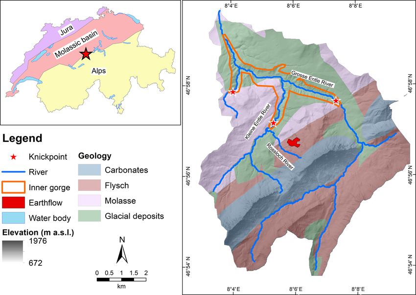
F. Clapuyt et al.: Spatio-temporal dynamics of sediment transfer systems                                                        1491

                                                                       record the volume of sediment exported or evacuated from
                                                                       a given surface area per unit of time (l 3 t −1 ), and quantify
                                                                       the rate of sediment transfer between landscape units, i.e.
                                                                       between hillslopes and channels. At annual scale, the ge-
                                                                       omorphic processes in the hillslope domain (100 –101 km2 )
                                                                       can be monitored using very high-resolution topographic
                                                                       reconstructions (Fig. 1e). At the decadal scale, the sedi-
                                                                       ment dynamics of first-order catchments can be quantified
                                                                       from time series of digital elevation models (DEMs) using
                                                                       classic photogrammetry (Fig. 1f). Catchment-averaged cos-
                                                                       mogenic radionuclide (CRN)-derived denudation rates pro-
                                                                       vide integrated geomorphic process rates over the millennial
                                                                       timescale (Fig. 1g). In the discussion of the results of this
                                                                       study, we will refer to this conceptual framework (Fig. 1) to
                                                                       contextualize the results.

Figure 1. Conceptual framework of the sediment dynamics in
Alpine landslide-affected first-order catchments. (a) Landslides are
                                                                       3     Material and methods
a stochastic process that mobilizes soil and regolith downslope.
(b) Landslide-derived material can temporarily be stored on the
slopes in landslide colluvial fans, (c) and/or be evacuated by de-     3.1    The Entle and Schimbrig catchments
bris flows to the fluvial system. (d) Hillslope–channel geomorphic
coupling (by, e.g., slope failures induced by river undercutting) is   Our study area is located in the northern foothills of the Cen-
particularly important for understanding the response of the geo-      tral Swiss Alps, between Bern and Lucerne (Fig. 2). The En-
morphic system to sediment pulses. The quantification of sediment      tle catchment has a drainage basin of 64 km2 , with an ele-
fluxes is achieved using (e) UAV-SfM framework, (f) classic pho-       vation ranging between 680 m a.s.l. at the outlet near Entle-
togrammetry, and (g) in situ produced cosmogenic radionuclides.        buch village and 1815 m on the Schimbrig summit. The study
                                                                       area lies at the intersection between the Swiss Plateau, i.e.
                                                                       the Molassic basin, and the frontal thrusts of the Alpine
ber of years (e.g. Berger et al., 2011; Fuller and Marden,             orogeny. The molasse unit, covering the lower reaches of
2010; Sutherland et al., 2002) to decades (e.g. Bennett et al.,        the catchment, is composed of Late Oligocene conglomer-
2013; Schwab et al., 2008) and millennia (e.g. Dingle et al.,          ate bedrock knobs, forming erosion-resistant low ridges. The
2018; Wang et al., 2017; West et al., 2014). In configurations         intermediate part of the catchment is covered by subalpine
where hillslopes are physically linked to channels (Fig. 1c),          flysch, while the higher SW–NE-oriented ridge is composed
the material derived from landsliding is effectively evacu-            of Cretaceous carbonate rocks of the Helvetic thrust sheet
ated by the fluvial system (e.g. Berger et al., 2011; Suther-          (Schlunegger et al., 2016b; Fig. 2). The Entle catchment is
land et al., 2002; Wang et al., 2017). The hillslope–channel           dissected by a 7 km long central inner gorge with two trib-
geomorphic coupling controls the propagation of sediment               utaries, i.e. the Grosse and the Kleine Entle, that are deeply
pulses from landslides to the river network (Fig. 1d). In              incised into a more than 100 m thick unconsolidated glacial
catchments with strong hillslope–channel geomorphic cou-               till. The glacial till was deposited during repetitive and ex-
pling by, e.g., debris flows entering the channel reach, we            tensive glaciations during the Pleistocene. Lateral and termi-
might expect to see a rapid response of the fluvial system             nal moraines deposited by the Entle glacier during the Last
to geomorphic events, such as stochastic landslide events. In          Glacial Maximum (LGM) are dissected by the Grosse and
well-coupled systems, the landslide-derived sediment fluxes            Kleine Entle rivers up to the headwaters (Fig. 2). The in-
for the hillslopes should show good correspondence with the            ner gorge contains knick zones in its longitudinal profile, and
catchment-wide sediment flux.                                          several cut terraces are visible. A 10 Be-based sediment bud-
   The downslope propagation of sediment from the hill-                get, which covers the last ca. 2000 years, highlighted that
slopes sources, namely landslides, debris flows, and collu-            incision rates in the inner gorge are more than 4 times higher
vial fans, to the channel network can be constrained us-               than in the non-incised reaches (Van den Berg et al., 2012).
ing a time–space approach. In this conceptual framework,               The study area experiences three types of mass movement
we propose to combine information derived from UAV-SfM                 processes over distinctive landscape units. Landslides cat-
techniques, classic photogrammetry, and in situ produced               egorized as earthflows mainly affect the flysch areas. This
cosmogenic radionuclides to quantify spatio-temporal pat-              type of mass movement is very common in flysch sedimen-
terns in denudation rates and sediment fluxes. Catchment-              tary sequences and represents more than 30 % of all mass
scale denudation rates quantify the surface lowering per               movements in Switzerland according to Lateltin et al. (1997).
unit of time (l t −1 ) and are scale-invariant. Sediment fluxes        Near the summits, rock falls are common phenomena, and

www.solid-earth.net/10/1489/2019/                                                                Solid Earth, 10, 1489–1503, 2019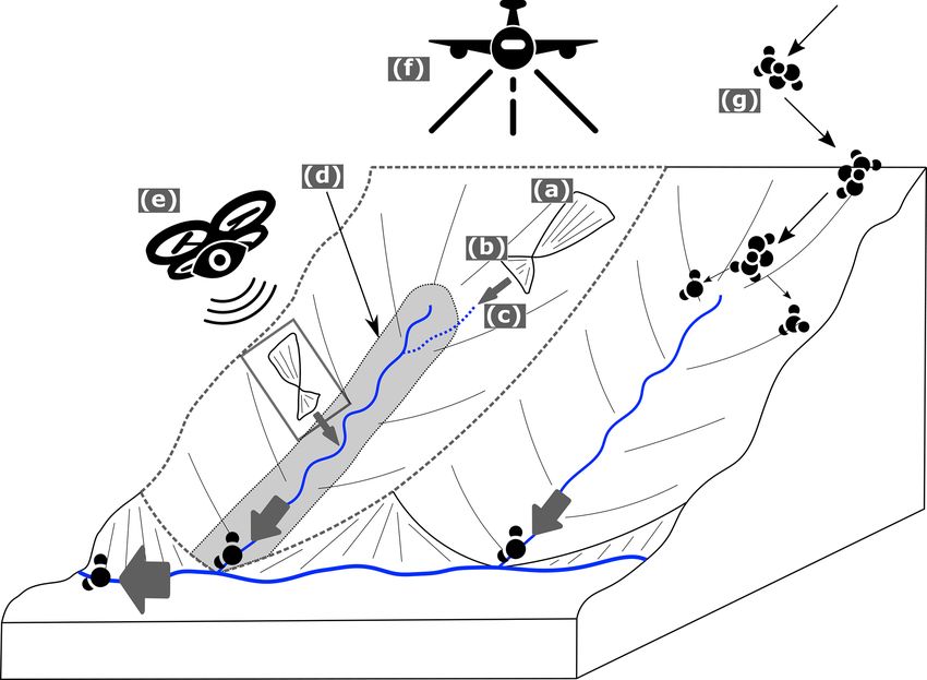
1492                                              F. Clapuyt et al.: Spatio-temporal dynamics of sediment transfer systems

the sidewalls of river valleys are subject to widespread rota-    of 0.04 m, defined based on the density of the point clouds.
tional and translational landslides.                              The accuracy of the time series ranges between 0.20 and
   Within the Entle River catchment, an earthflow named           0.24 m. The acquisition dates are October 2013, June 2014
Schimbrig has been particularly active over the last              and October 2015. As part of this sediment flux assessment,
150 years, acting as a sediment factory by excavating and         only the dataset of the 2014–2015 time interval was used
mobilizing sediments because of its deep rotational structure     because it covers the full spatial domain of the Schimbrig
(Clapuyt et al., 2017; Lopez-Saez et al., 2017; Savi et al.,      earthflow. The sediment budget was quantified from a dig-
2013; Schwab et al., 2008). It is located in the first-order      ital elevation model of differences (DoDs) between DSMs,
Schimbrig catchment, the latter draining successively into        using the Geomorphic Change Detection software (Wheaton
the Rossloch River and the Kleine Entle, before entering the      et al., 2010). In this paper, values are eventually reported on
trunk river, i.e. the Grosse Entle. The earthflow occurs on       an annual basis instead of over the entire period of interest
the hillslopes of the Schimbrig ridge and is not directly con-    (as in Clapuyt et al., 2017). Detailed information about the
nected to the Schimbrig stream, except during short episodes      methodology and extended results are available in Clapuyt et
when superimposed debris flows occur (Schwab et al., 2008).       al. (2017). Errors reported at the annual scale were computed
The Schimbrig earthflow consists of a fine-grained matrix         based on a uniform limit of detection applied to each topo-
of silt and mud, with centimetric to decimetric large clasts      graphic surface. Therefore, the associated error of the annual
(Clapuyt et al., 2017). The internal structure of the earth-      sediment fluxes should be seen as a maximum value. It is
flow is complex with nested rotational units (Clapuyt et al.,     likely that spatializing the error in very high-resolution to-
2017). Field observations revealed that a major earth slide       pographic measurements, i.e. accounting for the spatial vari-
with a surface lowering of up to 12 m occurred in the sum-        ation in photogrammetric and georeferencing precisions of
mer of 1994 after a succession of heavy precipitation events,     the reconstructions, would lead to an increase in the signal-
followed by debris flows until March 1995 (Schwab et al.,         to-noise ratio as shown by James et al. (2017).
2008). The intensity and spatial pattern of sediment redistri-
bution, as well as the internal structure of the earthflow have   3.3   Decadal sediment fluxes
rapidly evolved at the annual and decadal scale (Clapuyt et
al., 2017; Schwab et al., 2008). The Schimbrig catchment          The sediment fluxes at a decadal scale were derived from
also experiences scree-slope-like erosion processes in the up-    Schwab et al. (2008), who assessed sediment transport by the
per part on the Schimbrig ridge. Eroded material is stored at     Schimbrig earthflow and associated slopes, i.e. the Schim-
the foot of the slope, above river sources. Within the Schim-     brig catchment (Fig. 4), and linked it with suspended sedi-
brig catchment, the described earthflow affects ca. 25 % of       ment loads from a gauging station in the trunk stream, i.e.
the area and is the only active process in the catchment.         the Waldemme River. The authors based their analysis on a
                                                                  time series of DEMs derived from classic photogrammetry of
3.2    Annual sediment fluxes                                     aerial photographs acquired in 1962, 1986, 1993, and 1998.
                                                                  Each image of stereo-pairs was scanned with a ground res-
The annual sediment fluxes of the active part of the Schim-       olution of 0.4 m and georeferenced using a differential GPS.
brig earthflow (Fig. 3) were derived from time series of          Because of the scarcity of well-recognizable features through
very high-resolution topographic datasets from Clapuyt et         time, the associated volumetric errors of the photogrammet-
al. (2017). The earthflow has a rotational structure and is the   ric workflow ranged between 2 % for the 1986–1993 time
dominant source of sediment on the hillslopes. By quanti-         interval and 29 % for the 1962–1986 time interval. The sedi-
tatively comparing topographic datasets, we assessed spatial      ment budget based on DEMs provides two metrics. The total
patterns of surface lowering, i.e. a decrease in ground eleva-    sediment displaced corresponds to surface lowering while the
tion, and bulging, i.e. an increase in ground elevation. The      total sediment exported per year, i.e. the sediment flux enter-
overall sediment budget of the area affected by the earthflow,    ing the Rossloch River, is the balance between surface low-
i.e. the difference between surface lowering and bulging, is      ering and bulging. The ratio between both metrics indicates
indicative of the change in sediment volume through time.         the percentage of sediment mass evacuated compared to the
The sediment flux is derived at the base of the hillslopes        displaced mass. For this study, we converted the average sed-
at the transition between the hillslope and fluvial domains       iment fluxes that were expressed in tonnes per year into cu-
and represents the net flux of sediment from the earthflow to     bic metres per year, using a material density of 2.70 g cm−3
the Schimbrig River. The earthflow acts as a pure sediment        following a study by Gong (2005) on similar flysch units in
source on the hillslope.                                          Switzerland. A detailed methodology and results are avail-
   The 3-D topographic reconstructions were computed us-          able in the original paper of Schwab et al. (2008).
ing the structure-from-motion algorithm based on aerial pho-
tographs acquired by an unmanned aerial vehicle (Clapuyt
et al., 2016). Point clouds were subsequently interpolated
into digital surface models (DSMs) at a spatial resolution

Solid Earth, 10, 1489–1503, 2019                                                          www.solid-earth.net/10/1489/2019/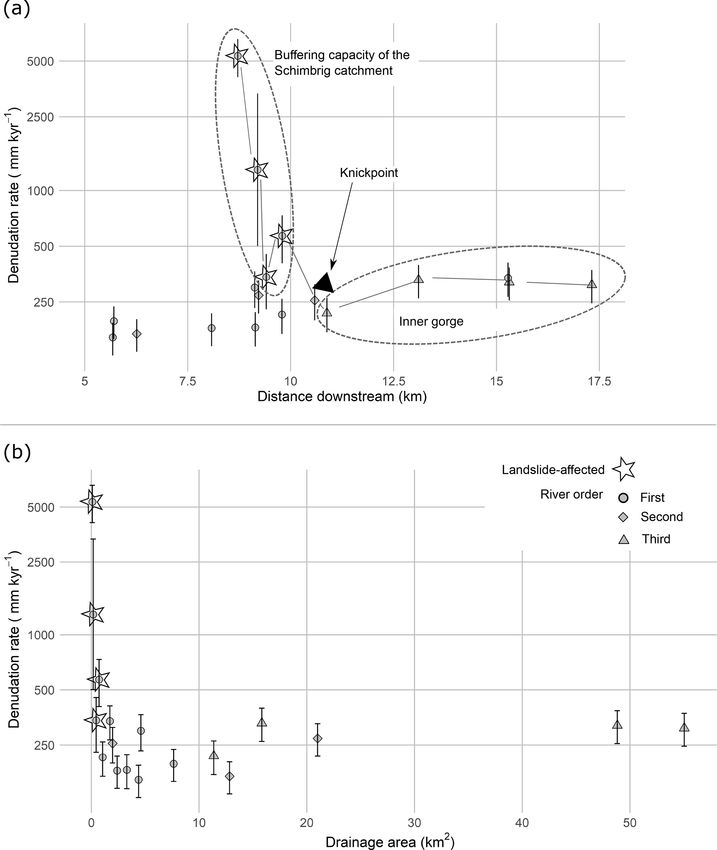
F. Clapuyt et al.: Spatio-temporal dynamics of sediment transfer systems 1493
Figure 2. Simplified geological and geomorphological settings of the Entle River catchment (after Van den Berg et al., 2012; Schlunegger et
al., 2016a). Inset: location of the study area in Switzerland. Source of the DEM: Swiss Federal Office of Topography Swisstopo (2013).
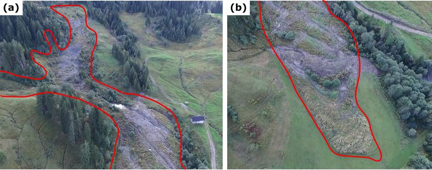
Figure 3. Illustration of the Schimbrig earthflow acting as a source of sediment in the river catchment. (a) Upper part with surface subsidence.
(b) Toe of the earthflow with surface bulging. The location of the Schimbrig earthflow is depicted in Fig. 2.
3.4 Millennial sediment fluxes tor. The remaining non-magnetic fraction was leached up to
10 times with 10 % hydrochloric acid to remove organic, cal-
The geomorphic process rates at a millennial scale were as- cium, and carbonate components. Then, samples were treated
sessed from catchment-averaged denudation rates derived up to four times with 5 % hydrofluoric acid in order to dis-
from in situ produced cosmogenic radionuclides in fluvial solve anything but quartz and also to remove any meteoric
sediments. In order to get a comprehensive dataset on the 10 Be left. After the leaching step, 157.8 µg of 9 Be carrier was
spatial variation in denudation rates in the Entle catchment, added to the clean quartz samples containing ca. 25 g of ma-
we collected river sand at eight locations in and around the terial. The purified quartz, i.e. ca. 10 % of the original sam-
Schimbrig catchment (Fig. 4) and combined the resulting ple weight, was subsequently dissolved in concentrated hy-
dataset with earlier work by Van den Berg et al. (2012). drofluoric acid, from which beryllium was extracted stepwise
The new samples were processed following the protocol de- using anion–cation exchange column chemistry. Remaining
scribed in Vanacker et al. (2007), which is similar to the one precipitates were oxidized and pressed into copper targets.
followed by Van den Berg et al. (2012). After washing and Finally, 10 Be/9 Be ratios were quantified using the 500 kV
sieving samples to the 0.25–1.00 mm fraction size, grains Tandy facility at ETH Zurich (Christl et al., 2013). These val-
were separated using a Frantz isodynamic magnetic separa-
www.solid-earth.net/10/1489/2019/ Solid Earth, 10, 1489–1503, 2019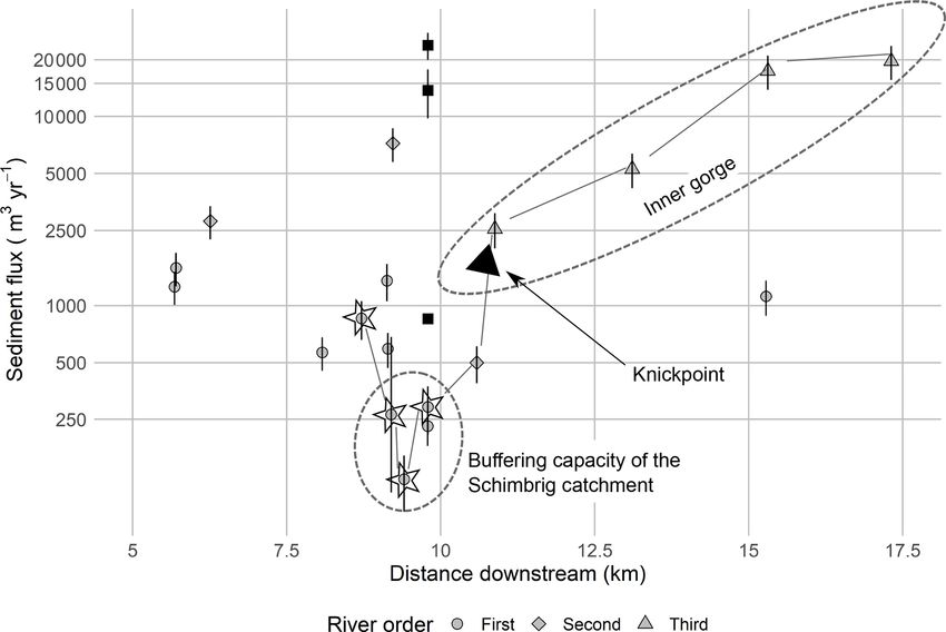
1494                                              F. Clapuyt et al.: Spatio-temporal dynamics of sediment transfer systems

ues were normalized with the in-house standard S2007N and         Table 1. Sediment fluxes for the 2014–2015 time interval from the
corrected with a blank 10 Be/9 Be ratio of 4.06±0.23×10⁻¹⁵ .      Schimbrig earthflow reported on an annual basis (modified from
Catchment-wide denudation rates were then computed from           Clapuyt et al., 2017).
the in situ produced 10 Be concentrations, i.e. from this study
and from earlier data published by Van den Berg et al. (2012),                                                  Estimate   Error (±)
using the catchment-averaged denudation rates from the cos-        Total area of surface bulging (m2 )           10 763           –
mogenic nuclide (CAIRN) method (Mudd et al., 2016). This           Total area of surface lowering (m2 )           9730            –
open-source calculator uses the topography to weight the
10 Be production rate and shielding. A 1 m digital terrain         Average rate of surface bulging (m yr−1 )         0.8         0.2
                                                                   Average rate of surface lowering (m yr−1 )        0.8         0.2
model (DTM) resampled to 30 m resolution was used to com-          Average net depth of difference (m yr−1 )        0.05        0.15
pute topographic shielding. Snow shielding was averaged for        Sediment flux (m3 yr−1 )                        1000        4000
each catchment individually. Snow cover is estimated using
an elevation-dependent mean annual snow cover database for
Switzerland (Auer, 2003). Following Jonas et al. (2009), an
                                                                  4.2   Sediment budget of the Schimbrig catchment at a
empirical relationship is used to derive the snow water equiv-
                                                                        decadal scale
alent thickness (SWE; g cm−2 ).We kept the default parame-
ters from Mudd et al. (2016) to run the CAIRN model, in-          Sediment fluxes were computed from 1962 to 1998 over the
cluding the sea-level high-latitude production rate of 4.30       first-order catchment affected by the earthflow, down to the
atoms g−1 yr−1 (based on Braucher et al., 2011). Long-term        confluence with the Rossloch River (Table 2; Fig. 4; Schwab
denudation rates obtained by the CAIRN calculator were            et al., 2008). The average sediment flux per year, evacu-
converted into sediment fluxes (m3 yr−1 ), by multiplying         ated from the catchment, varies over time, from 14 000 ±
them with the catchment area.                                     4000 m3 yr−1 for the 1962–1986 period to 850 ± 20 m3 yr−1
                                                                  for 1986–1993 to 24 000 ± 4000 m3 yr−1 for the 1993–1998
4     Results                                                     time interval. The data from Schwab et al. (2008) indicate
                                                                  that there is no clear link between the sediment fluxes ex-
4.1    Schimbrig earthflow sediment dynamics at the               ported from the Schimbrig catchment and the earthflow dy-
       annual scale                                               namics on the hillslopes. This is evident from the fact that
                                                                  the proportion of the mass evacuated from the study area to
When focusing on the active part of the Schimbrig earthflow       the total displaced mass varies greatly between 6 % and 89 %
(Fig. 4), we obtained a net mass flux of 1000 ± 4000 m3 yr−1      (Table 2).
for the 2014–2015 period (Table 1; Clapuyt et al., 2017). Ac-        During the 1962–1986 period, about 89 % of the displaced
counting for the associated error, the sediment flux is con-      mass was evacuated from the catchment, suggesting that sed-
sidered to be zero. The sediment budget for the 2013–2014         iment storage during this period was not significant. In con-
time interval supports this finding. In the eroding sites, the    trast, during the following periods (1986–1993, 1993–1998)
average denudation was 0.8 ± 0.2 m yr−1 and equivalent to         when the major earthflow event occurred in 1994, only up to
the accumulation that was observed in the bulging areas (Ta-      34 % of the mobilized earthflow material was evacuated.
ble 1). For the Schimbrig earthflow, Clapuyt et al. (2017)
reported a mean horizontal displacement of ca. 6.30 m yr−1        4.3   CRN concentrations in the Entle catchment
in the downslope direction. The UAV-SfM-derived data sug-
gest that the earthflow was in a dynamic equilibrium over         The 10 Be concentrations reported in this study are spatially
the 2014–2015 period, with earthflow-derived material being       and quantitatively consistent with earlier measurements by
temporarily stored on the slopes during the period of interest.   Norton et al. (2008) and Van den Berg et al. (2012) (Fig. 4).
   Notwithstanding the state of dynamic equilibrium, the data     Overall, the 10 Be concentrations (Table 3; Fig. 4; Van den
suggest large internal movements with a complex pattern of        Berg et al., 2012) range from 0.15 ± 0.53 × 10³ atoms g−1
sediment redistribution along the slope (Clapuyt et al., 2017).   in the upper part of the Schimbrig earthflow (CH-ENT-3) to
A succession of areas with terrain lowering and bulging char-     5.28 ± 0.26 × 10³ atoms g−1 in the upper part of the En-
acterized the earthflow along its longitudinal axis. The earth-   tle catchment, i.e. the Rothbach River (E-9). As the 10 Be
flow was re-adjusting to a new state of equilibrium after a       concentrations of the earthflow-affected area are low, rela-
massive failure that occurred in 1994. The sediment redis-        tively high errors are reported for the 10 Be concentrations of
tribution on the slopes was not associated with an increased      the earthflow-derived sediment (Table 3). The errors subse-
sediment export downstream. Between 2013 and 2015, the            quently propagated to the denudation rates, particularly for
hillslope domain was disconnected from the fluvial domain.        the samples from the Schimbrig stream draining the earth-
                                                                  flow, i.e. CH-ENT-1, CH-ENT-5, and CH-ENT-8.
                                                                     When analysing the 10 Be concentrations as a function of
                                                                  distance along the stream, we observe a clear and steady de-

Solid Earth, 10, 1489–1503, 2019                                                              www.solid-earth.net/10/1489/2019/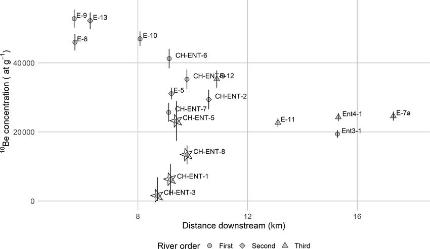
F. Clapuyt et al.: Spatio-temporal dynamics of sediment transfer systems 1495
Table 2. Sediment fluxes between 1962 and 1998 (after Schwab et al., 2008).
Time Total sediment Total sediment Average sediment Error in Percentage of mass
interval displaced exported flux evacuated sediment evacuated compared to
(103 t) (103 t) (m3 yr−1 ) flux (m3 yr−1 ) the displaced mass (%)
1962–1986 1003 892 14 000 4000 89
1986–1993 272 16 850 20 6
1993–1998 946 322 24 000 4000 34
1962–1998 1581 1229 13 000 2000 78
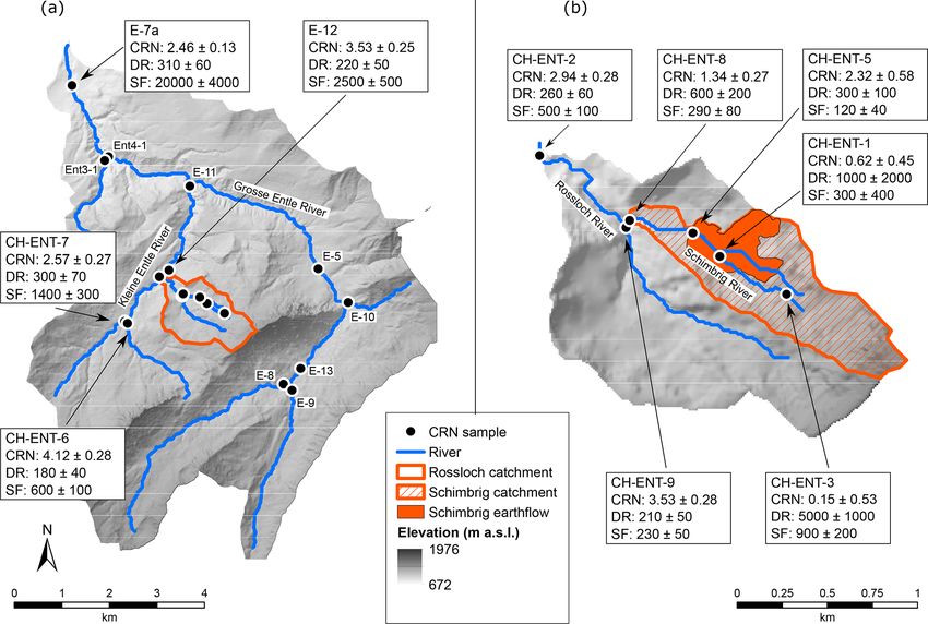
Figure 4. Location of CRN samples in the Entle catchment. CRN concentrations (CRN; ×103 atoms g−1 ), denudation rates (DR; mm kyr−1 )
and sediment fluxes (SF; m3 yr−1 ) displayed are discussed in the text. Values are available in Table 3. (a) Entle River and (b) Rossloch River
catchments. The Schimbrig catchment is depicted by the hatched polygon within the Rossloch catchment in panel (b). Source of the DEM:
Swiss Federal Office of Topography Swisstopo (2013).
crease in 10 Be concentrations with increasing downstream loch River, the CRN concentration of the earthflow-affected
distance (and catchment area) for the catchments not affected catchment equals 1.34 ± 0.27 atoms g−1 (CH-ENT-8), which
by active mass movements (Figs. 4, 5). This decrease in is at least 2 times lower than in the neighbouring catchment,
CRN concentrations could, at least in part, result from an i.e. 3.53 ± 0.28 atoms g−1 (CH-ENT-9).
increase in erosion rates downstream, as suggested in earlier
work by Korup and Schlunegger (2007) and Van den Berg
et al. (2012), or from a recycling of buried glacial sediment 5 Discussion
as the river cuts through 100 m thick unconsolidated glacial
deposits in the central part of the catchment (Fig. 2). 5.1 Sediment fluxes at the millennial scale
Figure 5 illustrates the strong contrast in the down-
stream change in 10 Be concentrations between the earthflow- Any variation in sediment mixing capacity or delivery from
affected Schimbrig and nearby catchments. Downslope of shielded or reworked sediment to the river channel may dilute
the Schimbrig earthflow, the river samples CH-ENT-1, CH- or increase the concentration in 10 Be in river sediments and
ENT-5, and CH-ENT-8 have systematically low CRN con- lead to over- or underestimation of the catchment-averaged
centrations that increase downstream. The latter is likely to denudation rates and sediment fluxes. Therefore, the geo-
reflect poor sediment mixing and long sediment residence morphological context of the Entle catchment potentially has
time in the alluvial domain. At the confluence with the Ross- three caveats when using 10 Be concentrations measured in
www.solid-earth.net/10/1489/2019/ Solid Earth, 10, 1489–1503, 2019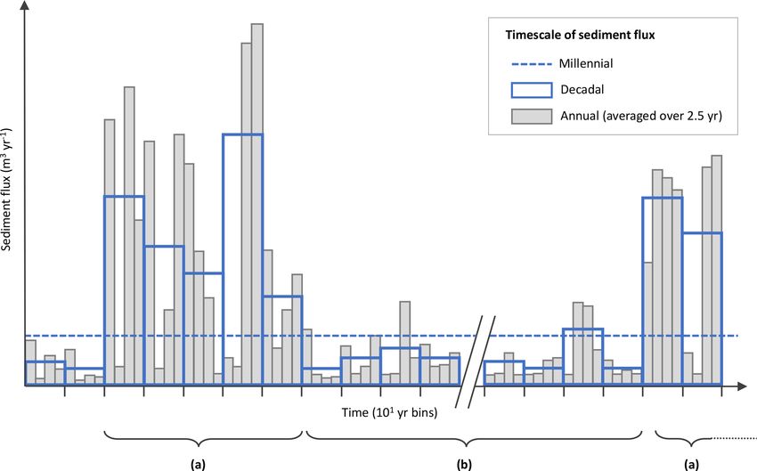
F. Clapuyt et al.: Spatio-temporal dynamics of sediment transfer systems

                                                                                                                                                                                                                                                                www.solid-earth.net/10/1489/2019/
                                                                           Table 3. 10 Be concentrations (atoms g−1 ), CRN-derived denudation rates (mm kyr−1 ) and sediment fluxes (m3 yr−1 ) for the Schimbrig catchment and other first-order rivers, i.e.
                                                                           samples CH-ENT-∗ , from this study and recomputed denudation rates and sediment fluxes for the Entle River catchment, i.e. samples Ent∗ and E-∗ , from Van den Berg et al. (2012).
                                                                           “dd” stands for “decimal degrees”.
                                                                            Sample       Drainage    Altitude      Lat   Long         Measured                  10 Be   Production   Topographic        Snow    Denudation        Sediment    Apparent
                                                                                             area         (m)     (dd)    (dd)   10 Be/9 Be ratio       concentration      scaling      shielding   shielding         rate             flux        age
                                                                                           (km2 )                                     (× 10−14 )    (×103 atoms g−1 )                                           (mm ky−1 )       (m3 yr−1 )       (yr)
                                                                            CH-ENT-1         0.20       1451    46.945   8.098              1.85          0.62 ± 0.45       3.306          0.954       0.904    1000 ± 2000       300 ± 400       650
                                                                            CH-ENT-2         1.96       1264    46.951   8.086              7.52          2.94 ± 0.28       2.965          0.974       0.917       260 ± 60       500 ± 100      2500
                                                                            CH-ENT-3         0.16       1500    46.943   8.104              1.17          0.15 ± 0.53       3.427          0.937       0.900    5000 ± 1000       900 ± 200       130
                                                                            CH-ENT-5         0.35       1373    46.946   8.097              3.50          2.32 ± 0.58       3.208          0.961       0.909      300 ± 100        120 ± 40      2167
                                                                            CH-ENT-6         3.25       1306    46.942   8.077             10.03          4.12 ± 0.28       3.069          0.950       0.914       180 ± 40       600 ± 100      3611
                                                                            CH-ENT-7         4.54       1336    46.942   8.076              6.88          2.57 ± 0.27       3.112          0.960       0.912       300 ± 70      1400 ± 300      2167
                                                                            CH-ENT-8         0.51       1325    46.947   8.092              4.07          1.34 ± 0.27       3.033          0.970       0.913      600 ± 200        290 ± 80      1083
                                                                            CH-ENT-9         1.07       1287    46.946   8.092              8.80          3.53 ± 0.28       2.983          0.977       0.915       210 ± 50        230 ± 50      3095
                                                                            Ent3-1           3.32       1076    46.956   8.062                 –          1.94 ± 0.11       2.434          0.979       0.954       340 ± 70      1100 ± 200      1912
                                                                            Ent4-1          54.60       1323    46.937   8.105                 –          2.43 ± 0.12       3.007          0.965       0.948       320 ± 70   17 000 ± 4000      2031
                                                                            E-5             26.53       1482    46.924   8.116                 –          3.11 ± 0.17       3.357          0.956       0.937       270 ± 60    7000 ± 1000       2407
                                                                            E-7a            63.56       1274    46.941   8.100                 –          2.46 ± 0.13       2.922          0.967       0.951       310 ± 60   20 000 ± 4000      2097
                                                                            E-8              8.05       1547    46.907   8.107                 –          4.60 ± 0.24       3.635          0.959       0.933       200 ± 40      1600 ± 300      3250
                                                                            E-9              7.83       1537    46.916   8.088                 –          5.28 ± 0.26       3.369          0.967       0.933       160 ± 30      1300 ± 300      4063
                                                                            E-10             3.13       1445    46.942   8.153                 –          4.70 ± 0.21       3.326          0.975       0.935       180 ± 40       600 ± 100      3611
                                                                            E-11            16.01       1231    46.939   8.081                 –          2.27 ± 0.13       2.871          0.969       0.949       330 ± 70    5000 ± 1000       1970

                                                                                                                                                                                                                                                                Solid Earth, 10, 1489–1503, 2019
                                                                            E-12            11.71       1280    46.934   8.076                 –          3.53 ± 0.25       2.989          0.964       0.946       220 ± 50      2500 ± 500      2955
                                                                            E-13            16.64       1534    46.913   8.099                 –          5.22 ± 0.24       3.511          0.960       0.934       170 ± 30      2800 ± 600      3824
1496
F. Clapuyt et al.: Spatio-temporal dynamics of sediment transfer systems 1497 Figure 5. 10 Be concentrations (atoms g−1 ) along the river network of the Entle catchment. Downstream distance is computed from the river source to the outlet of the Entle catchment. Samples from the earthflow-affected Schimbrig catchment are marked with a star. fluvial sediments to draw conclusions about the propagation trations in the Entle River basin, and the strong coherence of sediment pulses throughout the landscape. First, the ad- between our dataset and previously published data by Nor- mixture of buried glacial sediments due to the incision of the ton et al. (2008) and Van den Berg et al. (2012). As such, the Entle River in a 100 m thick layer of these deposits might effect of the stochastic input of earthflow-derived sediment is lead to dilution of the 10 Be signal in the lower reaches. How- likely to be buffered at the scale of the Schimbrig and Ross- ever, in glacial deposits of nearby sites (Trub River catch- loch catchments. ment, about 15 km to the west of our study site), Norton et Ignoring samples from the earthflow-affected catchment, al. (2008) reported 10 Be concentrations of glacial deposits the long-term denudation rates correlate positively with reaching 0.76 ± 0.13 × 10⁴ atoms g−1 at 8.5 m depth, and downstream distance (Table 3; Figs. 4, 6), with values rang- 3.58 ± 0.33 × 10⁴ atoms g−1 at 1.5 m depth. As these val- ing from 160 ± 30 mm kyr−1 (E-9) to 340 ± 70 mm kyr−1 ues are about 15 % to 50 % higher than the catchment-wide (Ent3-1). Characterized by a low variability, these values are CRN concentrations of nearby rivers, the incorporation of akin to 10 Be-derived denudation rates measured in similar buried glacial material in the inner gorge is not the principal Alpine tectonic settings (e.g. Norton et al., 2008). The in- cause of the low 10 Be concentrations that decrease systemati- crease in denudation rates with downstream distance along cally along the Entle River. Second, along with its small size, the Entle River is triggered by the ongoing relief rejuvena- the presence of an active earthflow in the Schimbrig catch- tion and incision of the inner gorge after the LGM (Van den ment might violate the assumption of steady-state denuda- Berg et al., 2012). The data also indicate that the river net- tion and sufficient sediment mixing, which are commonly work effectively evacuates sediments supplied to the river assumed when converting 10 Be concentrations of river sedi- channel. Accounting for the drainage area at each sampling ment into catchment-averaged 10 Be-derived denudation rates location, the long-term sediment fluxes (Table 3; Figs. 4, (e.g. Savi et al., 2014; Tofelde et al., 2018). We acknowl- 7) show the same positive correlation with downstream dis- edge that the dilution of 10 Be concentrations in river sedi- tance. The sediment fluxes range from 600 ± 100 m3 yr−1 ment due to stochastic inputs from landslides might lead to in upper first-order catchments (CH-ENT-6 and E-10) to an overestimation of CRN-derived denudation rates (Niemi 20 000 ± 4000 mm kyr−1 at the outlet of the Grosse Entle et al., 2005; Yanites et al., 2009). Therefore, CRN-derived River (E-7a). This increase of 2 orders of magnitude in sedi- denudation rates and subsequent sediment fluxes presented ment fluxes downstream corroborates the efficient evacuation hereunder will be taken as first-order or maximum estimates of sediment in the inner gorge. of the actual values (Puchol et al., 2014). Third, given that The earthflow-affected catchments show a different pat- sediment production and delivery to the river network is typ- tern that deviates from the overall trend of increasing de- ically stochastic in Alpine environments, the 10 Be concentra- nudation rates with distance downstream and catchment area. tions in river sediment might be highly variable in space and In the first-order Schimbrig catchment, long-term denuda- time as shown by Dingle et al. (2018) and West et al. (2014). tion rates correlate negatively with downstream distance (Ta- Figure 5 illustrates the systematic variation in 10 Be concen- ble 3; Figs. 4, 6). The denudation rates of the earthflow- www.solid-earth.net/10/1489/2019/ Solid Earth, 10, 1489–1503, 2019
1498                                                F. Clapuyt et al.: Spatio-temporal dynamics of sediment transfer systems

Figure 6. CRN-derived denudation rates (mm kyr−1 ) in the Entle catchment against (a) downstream distance and (b) drainage area. Down-
stream distance is computed from the river source to the outlet of the Entle catchment. Samples from the earthflow-affected Schimbrig
catchment are marked with a star. The grey lines connect the points that are hydrologically connected and part of the same fluvial system
(Schimbrig, Rossloch, Kleine Entle, and Grosse Entle rivers). Denudation rate values on the y axis are shown on a logarithmic scale.

affected first-order catchment are up to 1 order of magni-             on the slopes, hence accumulating 10 Be atoms in the collu-
tude higher than the rest of the Entle catchment, with val-            vial domain. Given that the catchment area of the first-order
ues ranging between 300 ± 100 mm kyr−1 in the intermedi-               earthflow-affected catchments is small, the absolute sediment
ate part (CH-ENT-5) and 5000±1000 mm kyr−1 (CH-ENT-3)                  fluxes are low with values ranging between 120 ± 40 and
in the upper part of the Schimbrig catchment. The variabil-            900 ± 200 m3 yr−1 . These long-term sediment fluxes com-
ity in denudation rates along the river is very high, with a 1         puted for the Rossloch catchment, i.e. including the Schim-
order of magnitude difference between minimum and maxi-                brig area, are 1 to 2 orders of magnitude lower than values
mum values, and it is spatially highly variable. For example,          computed in other parts of the Entle catchment (Figs. 4, 7).
the denudation rate in CH-ENT-5 is lower than the sites di-               The impact of landsliding on the long-term sediment dy-
rectly up- and downstream of this sampling location, reflect-          namics can be evaluated by comparing the denudation rates
ing the stochastic character of the sediment delivery from the         of the two intersecting catchments at the confluence with the
earthflow. The decrease in denudation rates with catchment             Rossloch River. At the outlet of the Schimbrig catchment,
area suggests that material initially displaced by the earth-          the denudation rate, i.e. 600 ± 200 mm kyr−1 (CH-ENT-8), is
flow is not directly evacuated to the river network but remains        at least 2 times higher than in the neighbouring catchment,

Solid Earth, 10, 1489–1503, 2019                                                                 www.solid-earth.net/10/1489/2019/
F. Clapuyt et al.: Spatio-temporal dynamics of sediment transfer systems                                                              1499

Figure 7. CRN-derived sediment fluxes (m3 yr−1 ) along the river network of the Entle catchment. Downstream distance is computed from
the river source to the outlet of the Entle catchment. Samples from the earthflow-affected Schimbrig catchment are marked with a star. Black
square markers represent the sediment flux computed by Schwab et al. (2008) for the period 1962–1998. Grey lines present the downstream
sequence of denudation rates along the Schimbrig, Rossloch, Kleine Entle, and Grosse Entle rivers. Sediment flux values on the y axis are
shown on a logarithmic scale.

i.e. 210 ± 50 mm kyr−1 (CH-ENT-9). The difference in de-                10−3 events km−2 yr−1 . The mean annual horizontal dis-
nudation rates between the two headwater catchments illus-              placements (Fig. 1a) that we measured within the earth-
trates that the sediment dynamics of both catchments were               flow, i.e. ca. 6.30 m yr−1 for the period 2014–2015, are rel-
probably very different over the last thousands of years as a           atively high in comparison with decimetric displacements
function of the stochastic input of sediment from landslides            reported in the western Slovakian Carpathians (Prokešová
(Fig. 1). When accounting for their catchment area, the sed-            et al., 2014), submetric (< 2 m yr−1 ) displacements reported
iment fluxes are very similar though with values of respec-             for the Eel earthflow in California (Mackey et al., 2009),
tively 290 ± 80 m3 yr−1 (CH-ENT-8) and 230 ± 50 m3 yr−1                 and metric to decametric displacements for the Super-Sauze
(CH-ENT-9).                                                             landslide in southern French Alps (Niethammer et al., 2012).
                                                                        The toe of the earthflow experienced a downslope movement
5.2   Temporal upscaling: the stochastic nature of                      of ca. 55 m between June 2014 and October 2015 (Fig. 1b,
      landsliding                                                       Clapuyt et al., 2017). Despite the important internal reorga-
                                                                        nization of the Schimbrig earthflow, its net sediment budget
                                                                        is roughly in equilibrium: sediment transfer from the collu-
Characterized by a relatively gentle Alpine topography, the
                                                                        vial to the fluvial domain (Fig. 1c) is minimal over the pe-
millennial geomorphic activity of the study area is mod-
                                                                        riod 2013–2015. The sediment mobilized by the earthflow is
erate in intensity. In comparison, the average CRN-derived
                                                                        buffered in the colluvial domain, due to the decoupling of the
denudation rate is 270 ± 140 mm kyr−1 in similar surround-
                                                                        hillslope–channel system (Fig. 1d) over the annual timescale.
ing areas, i.e. in the Alpine foreland, but increases to 900 ±
                                                                        In contrast to the limited annual sediment flux (period 2013–
300 mm kyr−1 in the high crystalline Alps (Wittmann et al.,
                                                                        2015) of the Schimbrig catchment, its decadal sediment flux
2007). Dendrogeomorphological data confirmed that the En-
                                                                        (period 1962–1998) equals 13 000 ± 2000 m3 yr−1 (Table 2;
tle River catchment has been affected by an active earth-
                                                                        Fig. 7). The decadal sediment flux is 2 orders of magnitude
flow at least over the past 150 years (Lopez-Saez et al.,
                                                                        higher than the sediment fluxes computed at the millennial
2017; Savi et al., 2013). Given the extent of its active part,
                                                                        timescale over the same spatial extent, i.e. 290 ± 80 m3 yr−1
i.e. ca. 0.5 km2 , the Schimbrig earthflow is a larger-than-
                                                                        (CH-ENT-8). We note here that the potential overestimation
average landslide (Stark and Hovius, 2001). Therefore, ac-
                                                                        of 10 Be-derived denudation rates due to the addition of 10 Be-
cording to the magnitude–frequency distribution of land-
                                                                        poor material from the earthflow (discussed in Sect. 5.1) does
slides (e.g. Hovius et al., 1997), this type of phenomenon
                                                                        not affect our interpretation.
is generally relatively infrequent, i.e. between 10−2 and

www.solid-earth.net/10/1489/2019/                                                                    Solid Earth, 10, 1489–1503, 2019
1500 F. Clapuyt et al.: Spatio-temporal dynamics of sediment transfer systems
Figure 8. Conceptual representation of the sediment fluxes over different timescales at the outlet of a first-order river catchment. (a) Periods
of high hillslope activity due to a landslide sediment pulse, resulting in intermittent hillslope–channel connections and in sediment export
to the river network at the annual scale. (b) Periods of low hillslope activity both at the annual and decadal scales, due to poor sediment
availability on slopes.
The sediment fluxes measured over different timescales re- the total sediment flux. The higher-order river network, i.e.
veal the episodic character of sediment production, delivery, the Kleine and Grosse Entle rivers, attenuates decadal sed-
and transport out of first-order Alpine catchments, such as iment pulses through the sediment cascade, during which
the Schimbrig and Rossloch catchments (Fig. 1). Landslides subsequent erosion and deposition occur over centennial
such as the Schimbrig earthflow generate sediment (Fig. 1a) timescales. The propagation of the sediment pulses (from,
that is temporarily stored in the colluvial domain (Fig. 1b) e.g., landslides) across the channel network is largely con-
and continues to accumulate 10 Be nuclides during storage. trolled by the hillslope–channel geomorphic coupling and
During short phases when hillslope and channel systems are the transport capacity of the fluvial systems. The latter act as
coupled, the colluvial deposits are evacuated out of the first- non-linear filters that smooth out spikes produced by episodic
order sediment stores. The discrepancy between decadal and landslide disturbances as also suggested by Jerolmack and
millennial sediment fluxes illustrates that these phases of Paola (2010). In this sense, we can consider the episodic sup-
hillslope–channel geomorphic coupling are short-lived and ply of sediment from landslides during intermittent phases
intermittent and interrupt long periods of largely uncoupled of hillslope–channel coupling as noise that is averaged out
colluvial and fluvial geomorphic systems (Fig. 8). During when considering sediment fluxes at longer timescales and
most of the time, the first-order catchments are transport- larger spatial scales. As our data show, one single distur-
limited, and sediment dynamics in the headwaters are un- bance (such as an earthflow) does not necessarily have an
coupled from the fluvial systems. impact on the long-term sediment budget of first-order catch-
ments. Rather, it is the cumulated effect of multiple land-
5.3 Spatial upscaling: the importance of landsliding for slides, which are intermittently connected to the channel net-
sediment budgets work at the decadal scale, along with sediment transport, that
may regulate sediment fluxes at the regional spatial scale
Episodic landslides, such as the Schimbrig earthflow, have over the millennial timescale.
the potential to mobilize large quantities of sediment at an-
nual or decadal timescales. The average sediment flux at the
decadal scale (1962–1998) out of the Schimbrig catchment, 6 Conclusions
i.e. 13 000 ± 2000 m3 yr−1 (Table 2; Fig. 7), represents about
65 % of the average sediment flux out of the Entle catchment To better constrain the evacuation of sediment produced by
at the millennial scale, i.e. 20 000 ± 4000 m3 yr−1 (E-7a; Ta- landslides on hillslopes and their propagation in the chan-
ble 3; Fig. 7). This illustrates that landslide-affected catch- nel network, we compiled geomorphic assessments at dif-
ments can act as principal point sources of sediment, as a ferent spatio-temporal scales of the Entle River catchment
sub-catchment covering 1 % of the area can provide 65 % of located in the foothills of the Central Swiss Alps. This
Solid Earth, 10, 1489–1503, 2019 www.solid-earth.net/10/1489/2019/F. Clapuyt et al.: Spatio-temporal dynamics of sediment transfer systems 1501
64 km2 mountainous river catchment has been affected by thanks to Marco Bravin for the help with sample leaching in the
the Schimbrig earthflow for more than 150 years. We quanti- soil lab. We also acknowledge Romain Delunel from Universität
fied (or benefitted from previous studies of) sediment fluxes Bern for the computation of the snow shielding factors, which
over annual, decadal, and millennial timescales using re- serve as inputs to derive long-term denudation rates. Efficient and
spectively UAV-SfM-based 3-D topographic reconstructions, reproducible research is possible thanks to open-source algorithms,
such as CAIRN, i.e. the CRN-derived denudation rates calculator,
classic photogrammetry, and in situ produced 10 Be cosmo-
developed by Simon Mudd and his colleagues. Finally, we would
genic radionuclides. Our unique spatio-temporal database of like to thank Luca Malatesta and one anonymous reviewer for their
sediment fluxes highlights the episodic character of sediment constructive comments, which helped us to better structure the
production, delivery, and transport out of first-order river paper and improve its quality.
catchments, i.e. the Schimbrig and Rossloch catchments. A
discrepancy of 2 orders of magnitude is observed between
annual, decadal, and millennial sediment fluxes at the out- Review statement. This paper was edited by Arjen Stroeven and re-
let of the Schimbrig catchment. It illustrates that phases of viewed by Luca C. Malatesta and one anonymous referee.
hillslope–channel geomorphic coupling are short-lived and
intermittent, and it interrupts long periods of largely un-
coupled colluvial and fluvial geomorphic systems. During
most of the time, the first-order catchments are transport- References
limited, and sediment dynamics in the headwaters are un-
coupled from the fluvial systems. Aalto, R., Dunne, T., and Guyot, J. L.: Geomorphic con-
Landslides such as the Schimbrig earthflow act as point trols on Andean denudation rates, J. Geol., 114, 85–99,
sources of sediment. Although they represent only 1 % of the https://doi.org/10.1086/498101, 2006.
total surface area, they can produce intermittently about 65 % Auer, M.: Regionalisierung von Schneeparametern – Eine Methode
of the average regional sediment flux. The impact of a sin- zur Darstellung von Schneeparametern im Relief, University of
gle sediment pulse is strongly attenuated at larger spatial and Berne, 97 pp., 2003.
temporal scales by sediment transport mechanisms. The lat- Benda, L. and Dunne, T.: Stochastic forcing of sediment supply to
ter tend to smooth out the spikes in sediment flux delivered channel networks from landsliding and debris flow, Water Re-
sour. Res., 33, 2849–2863, https://doi.org/10.1029/97WR02388,
by episodic landslide events. Therefore, the accumulation of
1997.
multiple sediment pulses, which are intermittently delivered
Bennett, G. L., Molnar, P., McArdell, B. W., Schlunegger, F., and
to the channel network during phases of hillslope–channel Burlando, P.: Patterns and controls of sediment production, trans-
geomorphic coupling, has rather a measurable impact on the fer and yield in the Illgraben, Geomorphology, 188, 68–82,
regional pattern of sediment fluxes. https://doi.org/10.1016/j.geomorph.2012.11.029, 2013.
Bennett, G. L., Molnar, P., McArdell, B. W., and Burlando, P.:
A probabilistic sediment cascade model of sediment trans-
Data availability. All datasets and code are available upon request. fer in the Illgraben, Water Resour. Res., 50, 1225–1244,
Please contact the first author for details. https://doi.org/10.1002/2013WR013806, 2014.
Berger, C., McArdell, B. W., and Schlunegger, F.: Sediment trans-
fer patterns at the Illgraben catchment, Switzerland: Implications
Author contributions. FC and VV conceived the conceptual model for the time scales of debris flow activities, Geomorphology,
on spatio-temporal sediment dynamics and designed the research 125, 421–432, https://doi.org/10.1016/j.geomorph.2010.10.019,
project. FC performed field surveys, prepared the samples for CRN 2011.
analysis with help of VV and JS, and was responsible for data anal- Bracken, L. J., Turnbull, L., Wainwright, J., and Bogaart, P.: Sed-
yses. MC performed the AMS measurements at ETH Zurich. KVO iment connectivity: A framework for understanding sediment
and FS contributed to the implementation of the research and to the transfer at multiple scales, Earth Surf. Process. Land., 40, 177–
analysis of the results. FC took the lead in writing the paper. All 188, https://doi.org/10.1002/esp.3635, 2015.
authors contributed to shaping the research, analyses, and paper. Braucher, R., Merchel, S., Borgomano, J., and Bourlès, D. L.:
Production of cosmogenic radionuclides at great depth: A
multi element approach, Earth Planet. Sc. Lett., 309, 1–9,
Competing interests. The authors declare that they have no conflict https://doi.org/10.1016/j.epsl.2011.06.036, 2011.
of interest. Christl, M., Vockenhuber, C., Kubik, P. W., Wacker, L., Lach-
ner, J., Alfimov, V., and Synal, H. A.: The ETH Zurich
AMS facilities: Performance parameters and reference materi-
als, Nucl. Instruments Methods Phys. Res. Sect. B, 294, 29–38,
Acknowledgements. The authors would like to thank
https://doi.org/10.1016/j.nimb.2012.03.004, 2013.
Jérome Schoonejans for the extended help and the careful
Clapuyt, F., Vanacker, V., and Van Oost, K.: Reproducibil-
supervision of the CRN extraction procedure in the Cosmo
ity of UAV-based earth topography reconstructions based on
Laboratory of the Georges Lemaître Centre for Earth and Climate
Structure-from-Motion algorithms, Geomorphology, 260, 4–15,
Research at the Université catholique de Louvain. We extend our
https://doi.org/10.1016/j.geomorph.2015.05.011, 2016.
www.solid-earth.net/10/1489/2019/ Solid Earth, 10, 1489–1503, 20191502 F. Clapuyt et al.: Spatio-temporal dynamics of sediment transfer systems Clapuyt, F., Vanacker, V., Schlunegger, F., and Van Oost, K.: factors and climate change Landslides in Flysch terranes of Unravelling earth flow dynamics with 3-D time series de- Switzerland?: Causal factors and climate change, Eclogae Geol. rived from UAV-SfM models, Earth Surf. Dynam., 5, 791–806, Helv., 90, 401–406, 1997. https://doi.org/10.5194/esurf-5-791-2017, 2017. Lopez-Saez, J., Morel, P., Corona, C., Bommer-Denns, B., Crozier, M. J. and Glade, T.: Frequency and magnitude of lands- Schlunegger, F., Berger, F., and Stoffel, M.: Tree-ring recon- liding: fundamental research issues, Z. Geomorphol., 115, 141– struction of reactivation phases of the Schimbrig landslide 155, 1999. (Swiss Alps), Géomorpho. Reli. Process. Environ., 23, 265–276, Delong, S. B., Prentice, C. S., Hilley, G. E., and Ebert, Y.: Multi- https://doi.org/10.4000/geomorphologie.11825, 2017. temporal ALSM change detection, sediment delivery, and pro- Mackey, B. H., Roering, J. J., and McKean, J. A.: Long- cess mapping at an active earthflow, Earth Surf. Process. Land., term kinematics and sediment flux of an active earth- 37, 262–272, https://doi.org/10.1002/esp.2234, 2012. flow, Eel River, California, Geology, 37, 803–806, Dingle, E. H., Sinclair, H. D., Attal, M., Rodés, Á., and Singh, https://doi.org/10.1130/G30136A.1, 2009. V.: Temporal variability in detrital 10 Be concentrations in a Malamud, B. D., Turcotte, D. L., Guzzetti, F., and Reichenbach, P.: large Himalayan catchment, Earth Surf. Dynam., 6, 611–635, Landslide inventories and their statistical properties, Earth Surf. https://doi.org/10.5194/esurf-6-611-2018, 2018. Process. Land., 29, 687–711, https://doi.org/10.1002/esp.1064, Fryirs, K.: (Dis)Connectivity in catchment sediment cascades: A 2004. fresh look at the sediment delivery problem, Earth Surf. Process. Montgomery, D. R. and Brandon, M. T.: Topographic controls Land., 38, 30–46, https://doi.org/10.1002/esp.3242, 2013. on erosion rates in tectonically active mountain ranges, Earth Fuller, I. C. and Marden, M.: Rapid channel response to vari- Planet. Sc. Lett., 201, 481–489, https://doi.org/10.1016/S0012- ability in sediment supply: Cutting and filling of the Tarndale 821X(02)00725-2, 2002. Fan, Waipaoa catchment, New Zealand, Mar. Geol., 270, 45–54, Mudd, S. M., Harel, M. A., Hurst, M. D., Grieve, S. W. D., and https://doi.org/10.1016/j.margeo.2009.10.004, 2010. Marrero, S. M.: The CAIRN method: Automated, reproducible Gong, G.: Physical Properties of Alpine Rocks: A Laboratory In- calculation of catchment-averaged denudation rates from cosmo- vestigation, University of Geneva, 142 pp., 2005. genic nuclide concentrations, Earth Surf. Dynam., 4, 655–674, Gran, K. B. and Czuba, J. A.: Sediment pulse evolution and https://doi.org/10.5194/esurf-4-655-2016, 2016. the role of network structure, Geomorphology, 277, 17–30, Niemi, N. A., Oskin, M., Burbank, D. W., Heimsath, A. M., and https://doi.org/10.1016/j.geomorph.2015.12.015, 2017. Gabet, E. J.: Effects of bedrock landslides on cosmogenically Harvey, A. M.: Coupling between hillslopes and channels in upland determined erosion rates, Earth Planet. Sc. Lett., 237, 480–498, fluvial systems: implications for landscape sensitivity, illustrated https://doi.org/10.1016/j.epsl.2005.07.009, 2005. from the Howgill Fells, northwest England, Catena, 42, 225–250, Niethammer, U., James, M. R., Rothmund, S., Travelletti, J., 2001. and Joswig, M.: UAV-based remote sensing of the Super- Heckmann, T. and Schwanghart, W.: Geomorphic coupling and Sauze landslide: Evaluation and results, Eng. Geol., 128, 2–11, sediment connectivity in an alpine catchment – Exploring sedi- https://doi.org/10.1016/j.enggeo.2011.03.012, 2012. ment cascades using graph theory, Geomorphology, 182, 89–103, Norton, K. P., von Blanckenburg, F., Schlunegger, F., Schwab, https://doi.org/10.1016/j.geomorph.2012.10.033, 2013. M., and Kubik, P. W.: Cosmogenic nuclide-based investigation Hovius, N., Stark, C. P., and Allen, P. A.: Sediment flux from a of spatial erosion and hillslope channel coupling in the tran- mountain belt derived by landslide mapping, Geology, 25, 231– sient foreland of the Swiss Alps, Geomorphology, 95, 474–486, 234, 1997. https://doi.org/10.1016/j.geomorph.2007.07.013, 2008. James, M. R., Robson, S., and Smith, M. W.: 3-D uncertainty-based Prokešová, R., Kardoš, M., Tábořík, P., Medved’ová, A., Stacke, topographic change detection with structure-from-motion pho- V., and Chudý, F.: Kinematic behaviour of a large earth- togrammetry: Precision maps for ground control and directly flow defined by surface displacement monitoring, DEM dif- georeferenced surveys, Earth Surf. Process. Land., 42, 1769– ferencing, and ERT imaging, Geomorphology, 224, 86–101, 1788, https://doi.org/10.1002/esp.4125, 2017. https://doi.org/10.1016/j.geomorph.2014.06.029, 2014. Jerolmack, D. J. and Paola, C.: Shredding of environmental sig- Puchol, N., Lavé, J., Lupker, M., Blard, P.-H., Gallo, F., France- nals by sediment transport, Geophys. Res. Lett., 37, 1–5, Lanord, C., and Team, A.: Grain-size dependent concentra- https://doi.org/10.1029/2010GL044638, 2010. tion of cosmogenic 10 Be and erosion dynamics in a landslide- Jonas, T., Marty, C., and Magnusson, J.: Estimating the dominated Himalayan watershed, Geomorphology, 224, 55–68, snow water equivalent from snow depth measure- https://doi.org/10.1016/j.geomorph.2014.06.019, 2014. ments in the Swiss Alps, J. Hydrol., 378, 161–167, Savi, S., Schneuwly-Bollschweiler, M., Bommer-Denns, B., Stof- https://doi.org/10.1016/j.jhydrol.2009.09.021, 2009. fel, M., and Schlunegger, F.: Geomorphic coupling between hill- Korup, O. and Schlunegger, F.: Bedrock landsliding, river incision, slopes and channels in the Swiss Alps, Earth Surf. Process. and transience of geomorphic hillslope-channel coupling: Evi- Land., 38, 959–969, https://doi.org/10.1002/esp.3342, 2013. dence from inner gorges in the Swiss Alps, J. Geophys. Res.- Savi, S., Norton, K., Picotti, V., Brardinoni, F., Akçar, N., Ku- Earth, 112, F0302, https://doi.org/10.1029/2006JF000710, 2007. bik, P. W., Delunel, R., and Schlunegger, F.: Effects of sedi- Korup, O., Densmore, A. L., and Schlunegger, F.: The role of land- ment mixing on 10 Be concentrations in the Zielbach catchment, slides in mountain range evolution, Geomorphology, 120, 77–90, central-eastern Italian Alps, Quat. Geochronol., 19, 148–162, https://doi.org/10.1016/j.geomorph.2009.09.017, 2010. https://doi.org/10.1016/j.quageo.2013.01.006, 2014. Lateltin, A., Beer, O., Raetzo, C., Lateltin, O., Raetzo, H., and Schlunegger, F., Anspach, O., Bieri, B., Böning, P., Kaufmann, Caron, C.: Landslides in flysch terranes of Switzerland?: causal Y., Lahl, K., Lonschinski, M., Mollet, H., Sachse, D., Schubert, Solid Earth, 10, 1489–1503, 2019 www.solid-earth.net/10/1489/2019/
You can also read