A pan-African high-resolution drought index dataset - Earth ...
←
→
Page content transcription
If your browser does not render page correctly, please read the page content below
Earth Syst. Sci. Data, 12, 753–769, 2020
https://doi.org/10.5194/essd-12-753-2020
© Author(s) 2020. This work is distributed under
the Creative Commons Attribution 4.0 License.

           A pan-African high-resolution drought index dataset
            Jian Peng1,2 , Simon Dadson1 , Feyera Hirpa1 , Ellen Dyer1 , Thomas Lees1 , Diego G. Miralles3 ,
                                   Sergio M. Vicente-Serrano4 , and Chris Funk5,6
                1 School    of Geography and the Environment, University of Oxford, OX1 3QY Oxford, UK
                                  2 Max Planck Institute for Meteorology, Hamburg, Germany
                          3 Hydro-Climatic Extremes Lab (H-CEL), Ghent University, Ghent, Belgium
       4 Instituto Pirenaico de Ecología, Consejo Superior de Investigaciones Científicas (IPE-CSIC) Zaragoza, Spain
        5 U.S. Geological Survey, Earth Resources Observation and Science Center, Sioux Falls, South Dakota, USA
                     6 Santa Barbara Climate Hazards Center, University of California, Santa Barbara, USA

                                 Correspondence: Jian Peng (jian.peng@ouce.ox.ac.uk)

                                  Received: 8 August 2019 – Discussion started: 7 October 2019
                       Revised: 22 January 2020 – Accepted: 22 February 2020 – Published: 31 March 2020

      Abstract. Droughts in Africa cause severe problems, such as crop failure, food shortages, famine, epidemics
      and even mass migration. To minimize the effects of drought on water and food security on Africa, a high-
      resolution drought dataset is essential to establish robust drought hazard probabilities and to assess drought
      vulnerability considering a multi- and cross-sectional perspective that includes crops, hydrological systems,
      rangeland and environmental systems. Such assessments are essential for policymakers, their advisors and
      other stakeholders to respond to the pressing humanitarian issues caused by these environmental hazards. In
      this study, a high spatial resolution Standardized Precipitation-Evapotranspiration Index (SPEI) drought dataset
      is presented to support these assessments. We compute historical SPEI data based on Climate Hazards group
      InfraRed Precipitation with Station data (CHIRPS) precipitation estimates and Global Land Evaporation Am-
      sterdam Model (GLEAM) potential evaporation estimates. The high-resolution SPEI dataset (SPEI-HR) pre-
      sented here spans from 1981 to 2016 (36 years) with 5 km spatial resolution over the whole of Africa. To facil-
      itate the diagnosis of droughts of different durations, accumulation periods from 1 to 48 months are provided.
      The quality of the resulting dataset was compared with coarse-resolution SPEI based on Climatic Research
      Unit (CRU) Time Series (TS) datasets, Normalized Difference Vegetation Index (NDVI) calculated from the
      Global Inventory Monitoring and Modeling System (GIMMS) project and root zone soil moisture modelled
      by GLEAM. Agreement found between coarse-resolution SPEI from CRU TS (SPEI-CRU) and the developed
      SPEI-HR provides confidence in the estimation of temporal and spatial variability of droughts in Africa with
      SPEI-HR. In addition, agreement of SPEI-HR versus NDVI and root zone soil moisture – with an average cor-
      relation coefficient (R) of 0.54 and 0.77, respectively – further implies that SPEI-HR can provide valuable
      information for the study of drought-related processes and societal impacts at sub-basin and district scales
      in Africa. The dataset is archived in Centre for Environmental Data Analysis (CEDA) via the following link:
      https://doi.org/10.5285/bbdfd09a04304158b366777eba0d2aeb (Peng et al., 2019a).

Published by Copernicus Publications.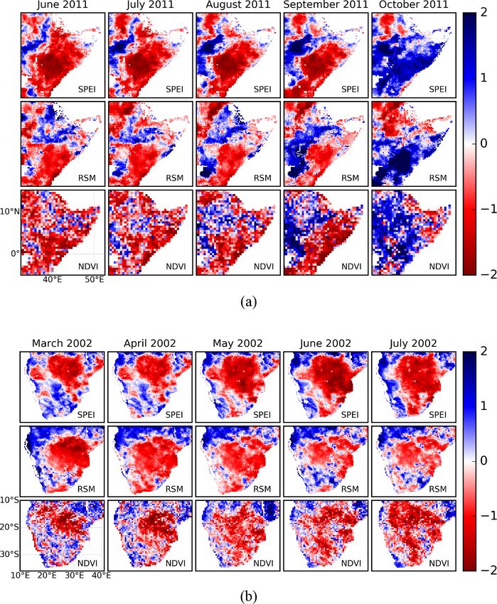
754                                                          J. Peng et al.: A pan-African high-resolution drought index dataset

1   Introduction                                                     different times of response of different usable water sources
                                                                     to precipitation deficits (Kumar et al., 2016; Zhao et al.,
Drought is a complex phenomenon that affects natural en-             2017). However, information on precipitation is inadequate
vironments and socioeconomic systems in the world (von               to characterize drought; in most definitions, drought condi-
Hardenberg et al., 2001; Vicente-Serrano, 2007; Van Loon,            tions also depend on the demand of water vapour from the at-
2015; Wilhite and Pulwarty, 2017). Impacts include crop fail-        mosphere. More recently, Vicente-Serrano et al. (2010) pro-
ure, food shortage, famine, epidemics and even mass mi-              posed an alternative drought index for SPI, which is called
gration (Wilhite et al., 2007; Ding et al., 2011; Zhou et al.,       Standardized Precipitation Evapotranspiration Index (SPEI).
2018). In recent years, severe events have occurred across           Compared to SPI, it considers not only the precipitation sup-
the world, such as the 2003 central Europe drought (García-          ply but also the atmospheric evaporative demand (Beguería
Herrera et al., 2010), the 2010 Russian drought (Spinoni             et al., 2010; Vicente-Serrano et al., 2012b). This makes the
et al., 2015), the 2011 Horn of Africa drought (Nicholson,           index more informative of the actual drought effects over
2014), the 2000 drought in southeastern Australia (van Dijk          various natural systems and socioeconomic sectors (Vicente-
et al., 2013; Peng et al., 2019c), the 2013–2014 California          Serrano et al., 2012b; Bachmair et al., 2016, 2018; Kumar
drought (Swain et al., 2014), the 2014 North China drought           et al., 2016; S. Sun et al., 2016, 2018; Peña-Gallardo et al.,
(Wang and He, 2015) and the 2015–2017 southern Africa                2018a, b).
drought (Baudoin et al., 2017; Muller, 2018). Widespread                For the calculation of SPEI, high-quality and long-term
negative effects of these droughts on natural and socioe-            observations of precipitation and atmospheric evaporative
conomic systems have been reported afterwards (Wegren,               demand are necessary. These observations may either come
2011; Arpe et al., 2012; Griffin and Anchukaitis, 2014; Mann         from ground-based station data or gridded data, such as satel-
and Gleick, 2015; Dadson et al., 2019; Marvel et al., 2019).         lite and reanalysis datasets. For example, the SPEIbase (Be-
Thus, there is a clear need to improve our knowledge about           guería et al., 2010) and the Global Precipitation Climatol-
the spatial and temporal variability of drought, which pro-          ogy Centre Drought Index (GPCC-DI) (Ziese et al., 2014)
vides a basis for quantifying drought impacts and the expo-          both provide SPEI datasets at a global scale. SPEIbase pro-
sure of society, the economy, and the environment over dif-          vides gridded SPEI with a 50 km spatial resolution and is
ferent areas and timescales (Pozzi et al., 2013; AghaKouchak         calculated from Climatic Research Unit (CRU) Time Series
et al., 2015).                                                       (TS) datasets, which are produced based on measurements
   Generally, drought is defined as a temporal anomaly char-         from more than 4000 ground-based weather stations across
acterized by a deficit of water compared with long-term              the world (Harris et al., 2014). The SPEI dataset provided by
conditions (Mishra and Singh, 2010; Van Loon, 2015).                 GPCC-DI has a spatial resolution of 1◦ and was generated
Droughts can typically be grouped into five types: meteo-            from GPCC precipitation (Becker et al., 2013; Schneider et
rological (precipitation deficiency), agricultural (soil mois-       al., 2016) and National Oceanic and Atmospheric Adminis-
ture deficiency), hydrological (runoff and/or groundwater            tration (NOAA)’s Climate Prediction Center (CPC) temper-
deficiency), socioeconomic (social response to water sup-            ature dataset (Fan and Van den Dool, 2008). Both of these
ply and demand) and environmental or ecologic (Keyantash             datasets have been applied for various drought-related stud-
and Dracup, 2002; AghaKouchak et al., 2015; Crausbay et              ies at global and regional scales (e.g. Chen et al., 2013;
al., 2017). These different drought categories involve differ-       Vicente-Serrano et al., 2013, 2016; Isbell et al., 2015; Q. Sun
ent event characteristics in terms of timing, intensity, dura-       et al., 2016; Deo et al., 2017). However, these global SPEI
tion and spatial extent, making it very difficult to character-      datasets’ spatial resolution are too coarse to be applied at
ize droughts quantitatively (Panu and Sharma, 2002; Lloyd-           district or sub-basin scales (Vicente-Serrano et al., 2017). A
Hughes, 2014; Vicente-Serrano, 2016). For this reason nu-            sub-basin-scale quantification of drought conditions is par-
merous drought indices have been proposed for precise appli-         ticularly crucial in regions such as Africa, in which geospa-
cations, and reviews of the available indices have been pro-         tial data and drought indices can be essential to manage ex-
vided by previous studies, such as Heim Jr. (2002), Keyan-           isting drought-related risks (Vicente-Serrano et al., 2012a)
tash and Dracup (2002), and Mukherjee et al. (2018). Van             and where in situ measurements are scarce (Trambauer et
Loon (2015) noted that there is no best drought index for            al., 2013; Masih et al., 2014; Anghileri et al., 2019). Over
all types of droughts because every index is designed for a          last century, Africa has been severely influenced by intense
specific drought type, thus multiple indices are required to         drought events, which has led to food shortages and famine
capture the multifaceted nature of drought. Nevertheless, the        in many countries (Anderson et al., 2012; Yuan et al., 2013;
Standardized Precipitation Index (SPI) is recommended by             Sheffield et al., 2014; Awange et al., 2016; Funk et al., 2018;
the World Meteorological Organization (WMO) for drought              Nicholson, 2018; Gebremeskel et al., 2019). Therefore, the
monitoring, which is calculated based solely on long-term            availability of a high-resolution drought index dataset may
precipitation data over different time spans (McKee et al.,          contribute to an improved characterization of drought risk
1993). The advantages of SPI are its relative simplicity and         and vulnerability and minimize its impact on water and food
its ability to characterize different types of droughts given the    security by supporting policymakers, water managers and

Earth Syst. Sci. Data, 12, 753–769, 2020                                              www.earth-syst-sci-data.net/12/753/2020/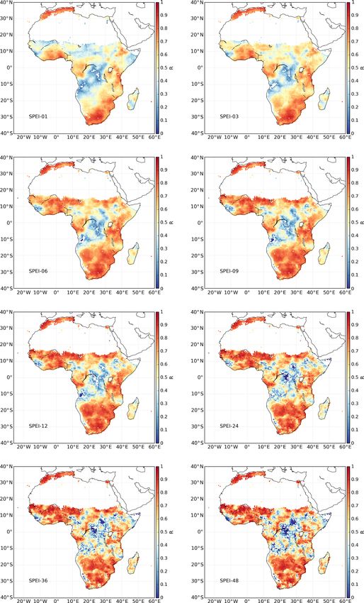
J. Peng et al.: A pan-African high-resolution drought index dataset                                                             755

stakeholders. Conveniently, with the advancement of satel-          Table 1. Categories of dry and wet conditions indicated by SPEI
lite technology, the estimation of precipitation and evapo-         values.
ration from remote sensing datasets is becoming more ac-
curate (Fisher et al., 2017). In particular, the long-term Cli-                     SPEI             Category
mate Hazards group InfraRed Precipitation with Station data                         2 and above      Extremely wet
(CHIRPS) (Funk et al., 2015a) precipitation dataset and                             1.5 to 1.99      Very wet
Global Land Evaporation Amsterdam Model (GLEAM) (Mi-                                1.0 to 1.49      Moderately wet
ralles et al., 2011) evaporation dataset provide high-quality                       −0.99 to 0.99    Near Normal
data for near-real-time drought monitoring. Here, we use                            −1.0 to −1.49    Moderately dry
CHIRPS and GLEAM datasets to develop a pan-African high                             −1.5 to −1.99    Severely dry
spatial resolution (5 km) SPEI dataset, which may be useful                         −2 and less      Extremely dry
to inform drought relief management strategies for the conti-
nent. The dataset covers the period from 1981 to 2016 and it
is comprehensively inter-compared with soil moisture, vege-         dataset was provided by Funk et al. (2015a). In this study,
tation index and coarse-resolution SPEI datasets.                   daily CHIRPS precipitation from 1981 to 2016 was used.

                                                                    2.1.2     GLEAM
2     Data and methodology
                                                                    GLEAM is designed to estimate land surface evaporation
                                                                    and root zone soil moisture from remote sensing observa-
2.1     Data
                                                                    tions and reanalysis data (Miralles et al., 2011; Martens et
2.1.1    CHIRPS                                                     al., 2017). Specifically, the Priestley–Taylor equation is used
                                                                    to calculate potential evaporation within GLEAM based on
CHIRPS is a recently developed high-resolution daily, pen-          near-surface temperature and net radiation, while the root
tadal, dekadal and monthly precipitation dataset (Funk et           zone soil moisture is obtained from a multilayer water bal-
al., 2015a). It was produced by blending a set of satellite-        ance driven by precipitation observations and updated with
only precipitation values (CHIRP) with additional monthly           microwave soil moisture estimates (Martens et al., 2017).
and pentadal station observations. CHIRP is based on in-            The actual evaporation is estimated by constraining poten-
frared cold cloud duration (CCD) estimates calibrated with          tial evaporation with a multiplicative evaporative stress fac-
the Tropical Rainfall Measuring Mission Multi-satellite Pre-        tor based on root zone soil moisture and vegetation opti-
cipitation Analysis version 7 (TMPA 3B42 v7) and the Cli-           cal depth (VOD) estimates. GLEAM version 3a (v3a) pro-
mate Hazards group Precipitation climatology (CHPclim).             vides global daily potential and actual evaporation, evapora-
CHPclim (Funk et al., 2015a, b) is based on station data            tive stress conditions, and root zone soil moisture from 1980
from the Food and Agriculture Organization (FAO) and the            to 2018 at spatial resolution of 0.25◦ (Martens et al., 2017)
Global Historical Climate Network (GHCN). Compared with             (see http://www.gleam.eu, last access: 29 March 2020).
other global precipitation datasets, such as Multi-Source           GLEAM datasets have already been comprehensively eval-
Weighted-Ensemble Precipitation (MSWEP) (Beck et al.,               uated against FLUXNET observations and used for multiple
2017) and Global Precipitation Climatology Project (GPCP)           hydro-meteorological applications (Greve et al., 2014; Mi-
(Adler et al., 2003), CHIRPS has several advantages: a long         ralles et al., 2014; Trambauer et al., 2014; Forzieri et al.,
period of record, high spatial resolution (5 km), low spatial       2017; Lian et al., 2018; Richard et al., 2018; Vicente-Serrano
biases and low temporal latency. It has been widely vali-           et al., 2018; Zhan et al., 2019). In particular, two recent stud-
dated and applied in various applications (e.g. Shukla et al.,      ies detected global drought conditions based on GLEAM po-
2014; Maidment et al., 2015; Duan et al., 2016; Zambrano-           tential and actual evaporation data (Vicente-Serrano et al.,
Bigiarini et al., 2017; Rivera et al., 2018). In particular, it     2018; Peng et al., 2019b). For this study, the GLEAM poten-
was recently validated over East Africa and Mozambique and          tial evaporation and root zone soil moisture were used.
demonstrated good performance compared to other precipi-
tation datasets (Toté et al., 2015; Dinku et al., 2018). Further-   2.1.3     CRU-TS
more, CHIRPS was specifically designed for drought moni-
toring over regions with deep convective precipitation, scarce      The global gridded CRU-TS datasets provide most widely
observation networks and complex topography (Funk et al.,           used climate variables, including precipitation, potential
2014). Several studies (e.g. Toté et al., 2015; Guo et al., 2017)   evaporation, diurnal temperature range, maximum and min-
have used CHIRPS for drought monitoring. Its high spatial           imum temperature, mean temperature, frost day frequency,
resolution makes it particularly suitable for local-scale stud-     cloud cover, and vapour pressure (Harris et al., 2014). The
ies, such as sub-basin drought monitoring, especially in ar-        CRU TS datasets were produced using angular distance
eas with complex topography. The detailed description of the        weighting (ADW) interpolation based on monthly mete-

www.earth-syst-sci-data.net/12/753/2020/                                               Earth Syst. Sci. Data, 12, 753–769, 2020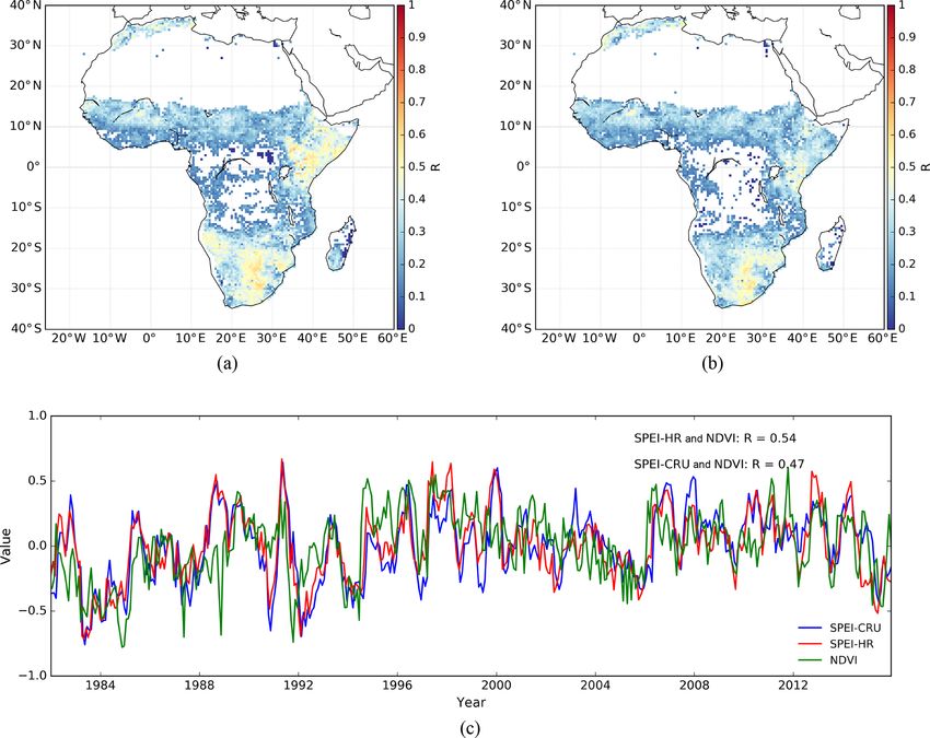
756 J. Peng et al.: A pan-African high-resolution drought index dataset
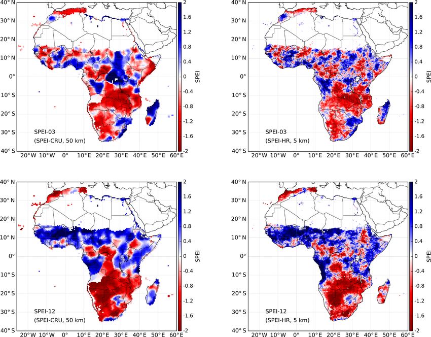
Figure 1. Spatial patterns of 3-month and 12-month SPEI at high spatial resolution (5 km) and coarse spatial resolution (50 km) in June 1995.
The high spatial resolution SPEI (SPEI-HR) is based on CHIRPS precipitation and GLEAM potential evaporation, while the coarse spatial
resolution SPEI (SPEI-CRU) is calculated from CRU TS datasets.
orological observations collected at ground-based stations (Beck et al., 2011; Pinzon and Tucker, 2014). For the current
across the world. The recently released CRU TS version 4.0.1 study, the latest version of GIMMS NDVI (3g.v1) was used,
covers the period 1901–2016 and provides monthly data at which covers the time period from 1981 to 2015 at biweekly
50 km spatial resolution. The CRU TS datasets have been temporal resolution and 8 km spatial resolution (Pinzon and
widely used for various applications since their release (e.g. Tucker, 2014).
van der Schrier et al., 2013; Chadwick et al., 2015; Delworth
et al., 2015; Jägermeyr et al., 2016). The SPEIbase dataset 2.2 Methods
was generated from CRU TS datasets (Beguería et al., 2010).
In this study, the CRU TS precipitation and potential evapo- 2.2.1 SPEI calculation
ration from 1981 to 2016 was used.
The SPEI proposed by Vicente-Serrano et al. (2010) has been
used for a wide variety of agricultural, ecological and hydro-
2.1.4 GIMMS NDVI meteorological applications (e.g. Schwalm et al., 2017; Nau-
mann et al., 2018; Jiang et al., 2019). It accounts for the im-
The Normalized Difference Vegetation Index (NDVI) can pacts of evaporation demand on droughts and inherits the
serve as a proxy of vegetation status and has been widely ap- simplicity and multi-temporal characteristics of SPI. The
plied to investigate the effects of drought on vegetation (e.g. procedure for SPEI calculation includes the estimation of a
Rojas et al., 2011; Vicente-Serrano et al., 2013, 2018; Törn- climatic water balance (namely the difference between pre-
ros and Menzel, 2014). The Global Inventory Monitoring and cipitation and potential evaporation), the aggregation of the
Modeling System (GIMMS) NDVI was generated based on climatic water balance over various timescales (e.g. 1, 3, 6,
Advanced Very-High-Resolution Radiometer (AVHRR) ob- 12, 24 months or more) and a fitting to a certain parame-
servations and has accounted for various deleterious effects, ter distribution. As suggested by Beguería et al. (2014) and
such as orbital drift, calibration loss and volcanic eruptions Vicente-Serrano and Beguería (2016), the log-logistic proba-
Earth Syst. Sci. Data, 12, 753–769, 2020 www.earth-syst-sci-data.net/12/753/2020/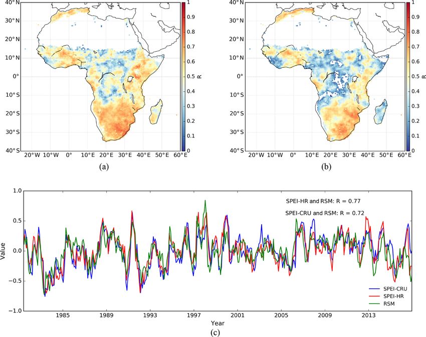
J. Peng et al.: A pan-African high-resolution drought index dataset                                                       757

Figure 2. Correlation (p < 0.05) between SPEI-HR and SPEI-CRU, with the number indicating different months.

www.earth-syst-sci-data.net/12/753/2020/                                              Earth Syst. Sci. Data, 12, 753–769, 2020
758                                                           J. Peng et al.: A pan-African high-resolution drought index dataset

                                                                      released root zone soil moisture (RSM) from GLEAM v3
                                                                      provides a great opportunity to evaluate whether soil mois-
                                                                      ture drought is well represented by SPEI. To facilitate di-
                                                                      rect comparison between SPEI, NDVI and RSM, both NDVI
                                                                      and RSM are standardized by subtracting their correspond-
                                                                      ing (1981–2016) mean and expressed the resulting anoma-
                                                                      lies as numbers of standard deviations. This standardization
                                                                      has been applied by many studies to evaluate drought indices
                                                                      (Anderson et al., 2011; Mu et al., 2013; Zhao et al., 2017).
                                                                      The correlation between SPEI and the standardized NDVI
                                                                      and RSM is quantified using Pearson’s correlation coefficient
                                                                      (R). In addition, the high-resolution SPEI from GLEAM and
                                                                      CHIRPS is also resampled to the same grid size of SPEI from
                                                                      CRU TS in order to quantify their correlation and disentan-
                                                                      gle whether the added value of the former arises from its in-
                                                                      creased accuracy or higher resolution. In the following sec-
                                                                      tion, the high-resolution (5 km) SPEI is referred to as SPEI-
Figure 3. Box plot of the correlation (p < 0.05) between SPEI-HR      HR, while the coarse 50 km resolution SPEI is referred to as
and SPEI-CRU for each month of the entire record. The results here    coarse spatial resolution SPEI (SPEI-CRU).
are based on 6-month SPEI, and the red line in each box represents
the median.
                                                                      3     Results and discussion

bility distribution is best for SPEI calculation, from which the      3.1    Inter-comparison between high- and
probability distribution of the difference between precipita-                coarse-resolution SPEI
tion and potential evaporation can be calculated as suggested         Figure 1 shows the spatial distribution of SPEI-HR and
by Vicente-Serrano et al. (2010) and Beguería et al. (2014).          SPEI-CRU at different resolutions for an example month
The negative and positive SPEI values indicate dry and wet            (June 1995). Figure 1a, b show the 3-month SPEI and 12-
conditions, respectively. Table 1 summarizes the category of          month SPEI, respectively. It can be seen that the high-
dry and wet conditions based on SPEI values. In this study,           resolution and coarse-resolution SPEI display quite similar
the CHIRPS and GLEAM datasets were used for SPEI calcu-               dry and wet patterns over the whole of Africa for both tempo-
lation at high spatial resolution (5 km). For comparison, the         ral scales. However, as expected, the SPEI-HR shows much
SPEI at 50 km was also calculated based on CRU TS datasets            more spatial detail that, as a result, reflects mesoscale geo-
for the same 1981–2016 period. It should be noted that the            graphic and climatic features, which highlights the advan-
SPEI over sparsely vegetated and barren areas were masked             tages of this new dataset. The differences in patterns be-
out based on the Moderate Resolution Imaging Spectrora-               tween 3-month and 12-month SPEI indicate the different wa-
diometer (MODIS) land cover product (MCD12Q1) (Friedl                 ter deficits caused by different aggregation timescales, which
et al., 2010) because SPEI is not reliable over these areas           can further separate agricultural, hydrological, environmen-
(Beguería et al., 2010, 2014; Zhao et al., 2017).                     tal and other droughts. For example, in June 1995, southern
                                                                      Africa showed persistent dry conditions over a prolonged pe-
2.2.2   Evaluation criteria                                           riod, while western Africa only showed a short-term drought.
                                                                         In order to quantify how different SPEI-HR is from SPEI-
The SPEIbase dataset (Beguería et al., 2010) was calculated           CRU, the correlation between them is calculated for each
with CRU TS dataset, which has been evaluated and applied             grid cell over the whole study period. Figure 2 shows the cor-
by many studies (e.g. Chen et al., 2013; Vicente-Serrano et           relations for timescales 1, 3, 6, 9, 12, 24, 36 and 48 months.
al., 2013; Isbell et al., 2015; Q. Sun et al., 2016; Greenwood        In general, the SPEI-HR and SPEI-CRU agree well in terms
et al., 2017; Um et al., 2017). The newly generated SPEI              of temporal variability with high positive correlations over
at high spatial resolution based on CHIRPS and GLEAM                  most of Africa for every timescale. However, relatively low
(SPEI-HR) is compared temporally and spatially to the SPEI            correlations appear in central Africa, and they become lower
calculated from CRU TS datasets. In addition, the NDVI can            as the SPEI timescale increases. This region has very few
also serve as an indicator for drought and vegetation health          station observations. It should be noted that the correlations
and to assess the performance of drought indices (Vicente-            shown here are statistically significant, with p values of less
Serrano et al., 2013; Aadhar and Mishra, 2017). Furthermore,          than 0.05. In addition, the average correlation between 6-
root zone soil moisture is an ideal hydrological variable for         month SPEI-CRU and SPEI-HR for each month of the year
agricultural (soil moisture) drought monitoring. The recently         is summarized in Fig. 3 using a box plot. In general, pos-

Earth Syst. Sci. Data, 12, 753–769, 2020                                               www.earth-syst-sci-data.net/12/753/2020/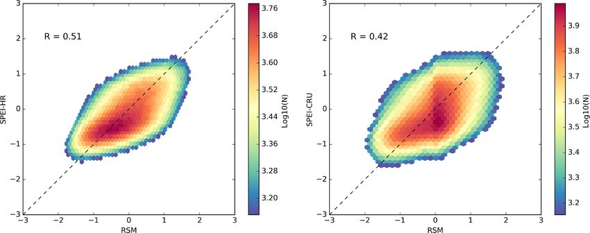
J. Peng et al.: A pan-African high-resolution drought index dataset                                                               759

Figure 4. Spatial maps of correlation between SPEI and root zone soil moisture (RSM) for 6-month SPEI: (a) SPEI-HR and (b) SPEI-CRU.
The time series of the African area mean RSM and SPEI are shown in (c), where R refers to the correlation coefficient. The correlations
shown here are all significant at the 95 % confidence level.

Table 2. The correlation (p < 0.05) between area mean RSM and SPEI at different timescales.

                                SPEI-01    SPEI-03     SPEI-06    SPEI-09     SPEI-12    SPEI-24     SPEI-36    SPEI-48
              R (SPEI-CRU)          0.52       0.74        0.72       0.64       0.56         0.41      0.26        0.16
              R (SPEI-HR)           0.49       0.76        0.77       0.69       0.62         0.44      0.29        0.18

itive correlations with a median larger than 0.6 (p < 0.05)           during the whole time period, respectively. In general, both
are found for every month. There are no substantial differ-           SPEI-HR and SPEI-CRU show strong correlations with RSM
ences in correlations between different months. Figure A1             over the whole African continent. Compared to SPEI-CRU,
in Appendix shows additional box plots for SPEI at other              the SPEI-HR shows higher correlations, particularly over
timescales.                                                           central Africa. Since Sect. 3.1 shows that relatively large dis-
                                                                      crepancy between SPEI-CRU and SPEI-HR exists over cen-
                                                                      tral Africa, the results presented here suggest a potentially
3.2   Comparison against root zone soil moisture and                  better performance of SPEI-HR compared with SPEI-CRU
      NDVI                                                            in this region.
To gain more insights into their significance and applicabil-            The time series of SPEI and RSM, averaged over the en-
ity, the SPEI datasets are compared with NDVI and RSM.                tire study area, are shown in Fig. 4c, together with the cor-
Figure 4 shows the results of the spatial and temporal com-           responding correlations. It can be seen that both SPEI-HR
parison between 6-month SPEI and RSM as indicated by                  and SPEI-CRU agree well with each other and with the RSM
Törnros and Menzel (2014). Figure 4a, b display the corre-            dynamics. Consistent with the results from the spatial cor-
lation (p < 0.05) of SPEI-HR and SPEI-CRU against RSM                 relation analysis, the SPEI-HR and SPEI-CRU show simi-

www.earth-syst-sci-data.net/12/753/2020/                                                Earth Syst. Sci. Data, 12, 753–769, 2020
760 J. Peng et al.: A pan-African high-resolution drought index dataset
Figure 5. Spatial maps of the correlation between SPEI and NDVI for 6-month SPEI: (a) SPEI-HR and (b) SPEI-CRU. The time series of
area mean NDVI and SPEI are shown in (c), where R refers to the correlation coefficient. The correlations shown here are all significant at
the 95 % confidence level.
Table 3. The correlation (p < 0.05) between area mean NDVI and SPEI at different timescales.
SPEI-01 SPEI-03 SPEI-06 SPEI-09 SPEI-12 SPEI-24 SPEI-36 SPEI-48
R (SPEI-CRU) 0.23 0.42 0.47 0.48 0.47 0.50 0.34 0.20
R (SPEI-HR) 0.31 0.51 0.54 0.56 0.57 0.57 0.44 0.29
lar results when compared with RSM (R = 0.77 for SPEI- Similar to the above analysis between SPEI and RSM,
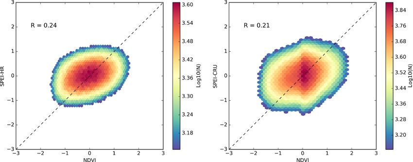
HR; R = 0.72 for SPEI-CRU). Furthermore, the scatter plots the comparison of results between SPEI and NDVI is shown
between 6-month SPEI and RSM for the entire data record in Fig. 5. First, Fig. 5a, b present the spatial distribution of
are shown in Appendix Fig. A2, where positive and signif- the correlations (p < 0.05) between SPEI-HR and NDVI and
icant correlations with RSM are found for both SPEI-HR between SPEI-CRU and NDVI, respectively. While correla-
(R = 0.51) and SPEI-CRU (R = 0.42). To explore the cor- tions are overall lower than for RSM, it can be seen that both
relation between RSM and different timescales of SPEI, Ta- SPEI datasets are positively correlated with NDVI over most
ble 2 summarizes the correlation value calculated in the same of the continent. It is also clear that SPEI-HR shows higher
way as Fig. 4c. It can be seen that the highest correlations correlations. The time series comparison between the area
against RSM are found at 3- and 6-month timescales. It mean SPEI and NDVI is shown in Fig. 5c. Both SPEI-HR
should be noted that satellite-data-driven estimates of root and SPEI-CRU show agreement with NDVI, with R = 0.54
zone soil moisture are more suitable for evaluating SPEI and R = 0.47, respectively. In addition, the comparison be-
compared to satellite-based top-layer soil moisture or reanal- tween 6-month SPEI and NDVI for the entire data record was
ysis soil moisture data (Mo et al., 2011; Xu et al., 2018). also calculated, with R = 0.24 for SPEI-HR and R = 0.21
for SPEI-CRU significant at 95 % confidence level (Fig. A3).
Earth Syst. Sci. Data, 12, 753–769, 2020 www.earth-syst-sci-data.net/12/753/2020/J. Peng et al.: A pan-African high-resolution drought index dataset 761 Figure 6. Evolution of the spatial patterns of 6-month SPEI-HR, NDVI and root zone soil moisture (RSM) during the 2011 East Africa drought (a) and 2002 southern Africa drought (b). While these correlations are admittedly low, overall results rizes the correlation between SPEI and NDVI at different suggest that the SPEI has a positive relation with NDVI, timescales. Compared with the results presented in Table 2 which is also reported by previous studies (e.g. Törnros and for RSM, the correlation with NDVI shown in Table 3 is also Menzel, 2014; Vicente-Serrano et al., 2018). The lower cor- generally lower, and the highest correlations appear between relations against NDVI than against RSM are likely due to 9- and 24-month SPEI (R > 0.5). complex physiological processes associated with vegetation Altogether, the comparisons between SPEI and RSM and and the fact that ecosystem state is driven by multiple vari- between SPEI and NDVI indirectly indicate the validity of ables other than water availability (Nemani et al., 2003). Fur- the generated SPEI datasets. Therefore, the generated high- thermore, there are also clearly documented lags between resolution SPEI-HR from satellite products has the potential precipitation and NDVI, with NDVI time series typically to improve upon the state of the art of drought assessment peaking 1 or even 2 months after the period of maximum over Africa. rainfall (Funk and Brown, 2006). Finally, Table 3 summa- www.earth-syst-sci-data.net/12/753/2020/ Earth Syst. Sci. Data, 12, 753–769, 2020
762                                                       J. Peng et al.: A pan-African high-resolution drought index dataset

3.3    Patterns of SPEI, RSM and NDVI during specific             5   Conclusions
       drought events
                                                                  The study presents a newly generated high-resolution SPEI
Most of Africa has suffered severe droughts in past decades       dataset (SPEI-HR) over Africa. The dataset is produced from
(Naumann et al., 2014; Blamey et al., 2018). Among them,          satellite-based CHIRPS precipitation and GLEAM poten-
the 2011 East Africa drought (Anderson et al., 2012; AghaK-       tial evaporation and covers the entire African continent over
ouchak, 2015) and 2002 southern Africa drought (Masih et          the time period from 1981 to 2016 with a spatial resolu-
al., 2014) were extremely severe and had devastating effects      tion of 5 km. The accumulated SPEI, ranging from 1 to 48
on the natural and socioeconomic environment. Taking these        months, is provided to facilitate applications from meteoro-
two events as case studies, the spatial patterns of the newly     logical to hydrological droughts. The SPEI-HR was com-
developed high-resolution 6-month SPEI-HR are analysed,           pared with widely used coarse-resolution SPEI data (SPEI-
together with the variability in NDVI and RSM. Figure 6a, b       CRU), GIMMS NDVI and GLEAM root zone soil moisture
show the evolution of 6-month SPEI, NDVI and RSM during           to investigate its capability for drought detection. In general,
the 2011 East Africa and the 2002 southern Africa drought,        the SPEI-HR has good correlation with SPEI-CRU tempo-
respectively. The 6-month periods end in the named month,         rally and spatially. They both agree well with NDVI and
with the 6-month June 2011 SPEI values based on data for          root zone soil moisture, although SPEI-HR displays higher
January to June. In general, these three variables reflect the    correlations overall. These results indicate the validity and
progressive dry-out during the events. For example, strong,       advantage of the newly developed high-resolution SPEI-HR
severe drought is revealed by the SPEI with values less than      dataset, and its unprecedentedly high spatial resolution offers
−1.5, coinciding with a decline in NDVI and RSM from June         important advantages for drought monitoring and assessment
to September 2011 over East Africa; the drought was offset        at district and river basin level in Africa.
in October. Similarly, dry and wet conditions variations dur-
ing the 2002 southern Africa drought were also captured by
the three variables. Despite differences over space and time,
results here demonstrate that the generated SPEI-HR cap-
tures the main drought conditions that are reflected by neg-
ative anomalies in NDVI and RSM and can thus be used to
study local drought-related processes and societal impacts in
Africa.

4     Data availability

The      high-resolution   SPEI     dataset  is   publicly
available     from     the   Centre    for  Environmental
Data Analysis (CEDA) from the following link:
https://doi.org/10.5285/bbdfd09a04304158b366777eba0d2aeb
(Peng et al., 2019a). It covers the whole of Africa at
a monthly temporal resolution and 5 km spatial resolu-
tion from 1981 to 2016 and is provided with geographic
latitude–longitude projection and NetCDF format.

Earth Syst. Sci. Data, 12, 753–769, 2020                                           www.earth-syst-sci-data.net/12/753/2020/
J. Peng et al.: A pan-African high-resolution drought index dataset 763 Appendix A Figure A1. Box plots of the correlation (p < 0.05) between SPEI-HR and SPEI-CRU for each month and the entire monthly record. www.earth-syst-sci-data.net/12/753/2020/ Earth Syst. Sci. Data, 12, 753–769, 2020
764                                                         J. Peng et al.: A pan-African high-resolution drought index dataset

Figure A2. Scatter plots between 6-month SPEI and RSM for the entire data record. R is correlation coefficient with p < 0.05, and the
colours denote the occurrence frequency of values.

Figure A3. Scatter plots between 6-month SPEI and NDVI for the entire data record. R is correlation coefficient with p < 0.05, and the
colours denote the occurrence frequency of values.

Earth Syst. Sci. Data, 12, 753–769, 2020                                               www.earth-syst-sci-data.net/12/753/2020/
J. Peng et al.: A pan-African high-resolution drought index dataset                                                                      765

Author contributions. JP developed the processing algorithm,            Anghileri, D., Li, C., Agaba, G., Kandel, M., Dash, J., Reeves, J.,
generated the dataset and drafted the manuscript. DGM and CF pro-         Lewis, L., Hill, C., and Sheffield, J.: Co-production and inter-
duced the GLEAM and CHIRPS data as input. SD, FH, ED and TL               disciplinary research in the BRECcIA project: bringing together
supported the generation of the dataset and the analysis of the re-       different expertise and actors for addressing water and food se-
sults. All authors contributed to the discussion, review and revision     curity challenges in sub-Saharan Africa, Geophys. Res. Abstr.,
of this paper.                                                            EGU2019-14992, EGU General Assembly 2019, Vienna, Aus-
                                                                          tria, 2019.
                                                                        Arpe, K., Leroy, S. A. G., Lahijani, H., and Khan, V.: Impact of
Competing interests. The authors declare that they have no con-           the European Russia drought in 2010 on the Caspian Sea level,
flict of interest.                                                        Hydrol. Earth Syst. Sci., 16, 19–27, https://doi.org/10.5194/hess-
                                                                          16-19-2012, 2012.
                                                                        Awange, J. L., Khandu, Schumacher, M., Forootan, E., and Heck,
Acknowledgements. This work is supported by the UK Space                  B.: Exploring hydro-meteorological drought patterns over the
Agency’s International Partnership Programme (417000001429).              Greater Horn of Africa (1979–2014) using remote sensing and
Diego G. Miralles acknowledges funding from the European Re-              reanalysis products, Adv. Water Res., 94, 45-59, 2016.
search Council (ERC) under grant agreement no. 715254 (DRY–2–           Bachmair, S., Stahl, K., Collins, K., Hannaford, J., Acreman, M.,
DRY). Simon Dadson is also funded by the Natural Environment              Svoboda, M., Knutson, C., Smith, K. H., Wall, N., and Fuchs,
Research Council (NE/M020339/1). Chris Funk is supported by the           B.: Drought indicators revisited: the need for a wider consid-
U.S. Geological Survey’s Drivers of Drought program and NASA              eration of environment and society, Wiley Interdisciplinary Re-
Harvest Program grant Z60592017.                                          views: Water, 3, 516–536, 2016.
                                                                        Bachmair, S., Tanguy, M., Hannaford, J., and Stahl, K.: How
                                                                          well do meteorological indicators represent agricultural and for-
                                                                          est drought across Europe?, Environ. Res. Lett., 13, 034042,
Financial support. This research has been supported by the UK
                                                                          https://doi.org/10.1088/1748-9326/aaafda, 2018.
Space Agency’s International Partnership Programme (grant no.
                                                                        Baudoin, M.-A., Vogel, C., Nortje, K., and Naik, M.: Living with
417000001429).
                                                                          drought in South Africa: lessons learnt from the recent El Niño
                                                                          drought period, Int. J. Disast. Risk Re., 23, 128–137, 2017.
                                                                        Beck, H. E., McVicar, T. R., van Dijk, A. I., Schellekens, J., de Jeu,
Review statement. This paper was edited by Alexander Gelfan               R. A., and Bruijnzeel, L. A.: Global evaluation of four AVHRR–
and reviewed by two anonymous referees.                                   NDVI data sets: Intercomparison and assessment against Landsat
                                                                          imagery, Remote Sens. Environ., 115, 2547–2563, 2011.
                                                                        Beck, H. E., van Dijk, A. I. J. M., Levizzani, V., Schellekens,
                                                                          J., Miralles, D. G., Martens, B., and de Roo, A.: MSWEP: 3-
References                                                                hourly 0.25◦ global gridded precipitation (1979–2015) by merg-
                                                                          ing gauge, satellite, and reanalysis data, Hydrol. Earth Syst. Sci.,
Aadhar, S. and Mishra, V.: High-resolution near real-time                 21, 589–615, https://doi.org/10.5194/hess-21-589-2017, 2017.
  drought monitoring in South Asia, Scientific Data, 4, 170145,         Becker, A., Finger, P., Meyer-Christoffer, A., Rudolf, B., Schamm,
  https://doi.org/10.1038/sdata.2017.145, 2017.                           K., Schneider, U., and Ziese, M.: A description of the global
Adler, R. F., Huffman, G. J., Chang, A., Ferraro, R., Xie, P.-P.,         land-surface precipitation data products of the Global Precipita-
  Janowiak, J., Rudolf, B., Schneider, U., Curtis, S., Bolvin, D.,        tion Climatology Centre with sample applications including cen-
  Gruber, A., Susskind, J., Arkin, P., and Nelkin, E.: The Version-2      tennial (trend) analysis from 1901–present, Earth Syst. Sci. Data,
  Global Precipitation Climatology Project (GPCP) Monthly Pre-            5, 71–99, https://doi.org/10.5194/essd-5-71-2013, 2013.
  cipitation Analysis (1979–Present), J. Hydrometeorol., 4, 1147–       Beguería, S., Vicente-Serrano, S. M., and Angulo-Martínez, M.: A
  1167, 2003.                                                             multiscalar global drought dataset: the SPEIbase: a new gridded
AghaKouchak, A.: A multivariate approach for persistence-based            product for the analysis of drought variability and impacts, B.
  drought prediction: Application to the 2010–2011 East Africa            Am. Meteorol. Soc., 91, 1351–1356, 2010.
  drought, J. Hydrol., 526, 127–135, 2015.                              Beguería, S., Vicente-Serrano, S. M., Reig, F., and Latorre, B.: Stan-
AghaKouchak, A., Farahmand, A., Melton, F. S., Teixeira, J., An-          dardized precipitation evapotranspiration index (SPEI) revisited:
  derson, M. C., Wardlow, B. D., and Hain, C. R.: Remote sens-            parameter fitting, evapotranspiration models, tools, datasets and
  ing of drought: Progress, challenges and opportunities, Rev. Geo-       drought monitoring, Int. J. Climatol., 34, 3001–3023, 2014.
  phys., 53, 452–480, 2015.                                             Blamey, R. C., Kolusu, S. R., Mahlalela, P., Todd, M. C., and Rea-
Anderson, M. C., Hain, C., Wardlow, B., Pimstein, A., Mecikalski,         son, C. J. C.: The role of regional circulation features in regulat-
  J. R., and Kustas, W. P.: Evaluation of drought indices based on        ing El Niño climate impacts over southern Africa: A comparison
  thermal remote sensing of evapotranspiration over the continen-         of the 2015/2016 drought with previous events, Int. J. Climatol.,
  tal United States, J. Climate, 24, 2025–2044, 2011.                     38, 4276–4295, https://doi.org/10.1002/joc.5668, 2018.
Anderson, W. B., Zaitchik, B. F., Hain, C. R., Anderson, M. C.,         Chadwick, R., Good, P., Martin, G., and Rowell, D. P.:
  Yilmaz, M. T., Mecikalski, J., and Schultz, L.: Towards an in-          Large rainfall changes consistently projected over substan-
  tegrated soil moisture drought monitor for East Africa, Hydrol.         tial areas of tropical land, Nat. Clim. Change, 6, 177–181,
  Earth Syst. Sci., 16, 2893–2913, https://doi.org/10.5194/hess-16-       https://doi.org/10.1038/nclimate2805, 2015.
  2893-2012, 2012.

www.earth-syst-sci-data.net/12/753/2020/                                                    Earth Syst. Sci. Data, 12, 753–769, 2020
766 J. Peng et al.: A pan-African high-resolution drought index dataset Chen, T., Werf, G. R., Jeu, R. A. M., Wang, G., and Dolman, temperatures in recent African droughts, Q. J. Roy. Meteor. Soc., A. J.: A global analysis of the impact of drought on net pri- 144, 360–383, 2018. mary productivity, Hydrol. Earth Syst. Sci., 17, 3885–3894, Funk, C. C. and Brown, M. E.: Intra-seasonal NDVI change projec- https://doi.org/10.5194/hess-17-3885-2013, 2013. tions in semi-arid Africa, Remote Sens. Environ., 101, 249–256, Crausbay, S. D., Ramirez, A. R., Carter, S. L., Cross, M. S., Hall, K. 2006. R., Bathke, D. J., Betancourt, J. L., Colt, S., Cravens, A. E., and Funk, C. C., Peterson, P. J., Landsfeld, M. F., Pedreros, D. H., Dalton, M. S.: Defining ecological drought for the twenty-first Verdin, J. P., Rowland, J. D., Romero, B. E., Husak, G. J., century, B. Am. Meteorol. Soc., 98, 2543–2550, 2017. Michaelsen, J. C., and Verdin, A. P.: A quasi-global precipita- Dadson, S. J., Lopez, H. P., Peng, J., and Vora, S.: Hydro- tion time series for drought monitoring, US Geological Survey climatic Extremes and Climate Change, Water Science, Pol- Data Series, 832, 1–12, https://doi.org/10.3133/ds832, 2014. icy, and Management: A Global Challenge, Wiley, 11–28, García-Herrera, R., Díaz, J., Trigo, R. M., Luterbacher, J., and Fis- https://doi.org/10.1002/9781119520627.ch2, 2019. cher, E. M.: A review of the European summer heat wave of Delworth, T. L., Zeng, F., Rosati, A., Vecchi, G. A., and Wittenberg, 2003, Crit. Rev. Env. Sci. Tec., 40, 267–306, 2010. A. T.: A Link between the Hiatus in Global Warming and North Gebremeskel, G., Tang, Q., Sun, S., Huang, Z., Zhang, American Drought, J. Climate, 28, 3834–3845, 2015. X., and Liu, X.: Droughts in East Africa: Causes, im- Deo, R. C., Byun, H.-R., Adamowski, J. F., and Begum, K.: Ap- pacts and resilience, Earth-Sci. Rev., 193, 146—161, plication of effective drought index for quantification of meteo- https://doi.org/10.1016/j.earscirev.2019.04.015, 2019. rological drought events: a case study in Australia, Theor. Appl. Greenwood, S., Ruiz-Benito, P., Martínez-Vilalta, J., Lloret, F., Climatol., 128, 359–379, 2017. Kitzberger, T., Allen, C. D., Fensham, R., Laughlin, D. C., Ding, Y., Hayes, M. J., and Widhalm, M.: Measuring economic im- Kattge, J., and Bönisch, G.: Tree mortality across biomes is pro- pacts of drought: a review and discussion, Disaster Prev. Manag., moted by drought intensity, lower wood density and higher spe- 20, 434–446, 2011. cific leaf area, Ecol. Lett., 20, 539–553, 2017. Dinku, T., Funk, C., Peterson, P., Maidment, R., Tadesse, T., Greve, P., Orlowsky, B., Mueller, B., Sheffield, J., Reichstein, Gadain, H., and Ceccato, P.: Validation of the CHIRPS satellite M., and Seneviratne, S. I.: Global assessment of trends in rainfall estimates over eastern Africa, Q. J. Roy. Meteor. Soc., wetting and drying over land, Nat. Geosci., 7, 716–721, 144, 292–312, https://doi.org/10.1002/qj.3244, 2018. https://doi.org/10.1038/ngeo22472014, 2014. Duan, Z., Liu, J., Tuo, Y., Chiogna, G., and Disse, M.: Evaluation Griffin, D. and Anchukaitis, K. J.: How unusual is the 2012–2014 of eight high spatial resolution gridded precipitation products in California drought?, Geophys. Res. Lett., 41, 9017–9023, 2014. Adige Basin (Italy) at multiple temporal and spatial scales, Sci. Guo, H., Bao, A., Liu, T., Ndayisaba, F., He, D., Kurban, A., and Total Environ., 573, 1536–1553, 2016. De Maeyer, P.: Meteorological drought analysis in the Lower Fan, Y. and Van den Dool, H.: A global monthly land surface air Mekong Basin using satellite-based long-term CHIRPS product, temperature analysis for 1948–present, J. Geophys. Res.-Atmos., Sustainability, 9, 901, https://doi.org/10.3390/su9060901, 2017. 113, D01103, https://doi.org/10.1029/2007JD008470, 2008. Harris, I., Jones, P. D., Osborn, T. J., and Lister, D. H.: Updated Fisher, J. B., Melton, F., Middleton, E., Hain, C., Anderson, high-resolution grids of monthly climatic observations – the M., Allen, R., McCabe, M. F., Hook, S., Baldocchi, D., and CRU TS3.10 Dataset, Int. J. Climatol., 34, 623–642, 2014. Townsend, P. A.: The future of evapotranspiration: Global re- Heim Jr., R. R.: A review of twentieth-century drought indices used quirements for ecosystem functioning, carbon and climate feed- in the United States, B. Am. Meteorol. Soc., 83, 1149–1165, backs, agricultural management, and water resources, Water Re- 2002. sour. Res., 53, 2618–2626, 2017. Isbell, F., Craven, D., Connolly, J., Loreau, M., Schmid, B., Forzieri, G., Alkama, R., Miralles, D. G., and Cescatti, A.: Satel- Beierkuhnlein, C., Bezemer, T. M., Bonin, C., Bruelheide, H., lites reveal contrasting responses of regional climate to the de Luca, E., Ebeling, A., Griffin, J. N., Guo, Q., Hautier, Y., widespread greening of Earth, Science, 356, 1180–1184, 2017. Hector, A., Jentsch, A., Kreyling, J., Lanta, V., Manning, P., Friedl, M. A., Sulla-Menashe, D., Tan, B., Schneider, A., Ra- Meyer, S. T., Mori, A. S., Naeem, S., Niklaus, P. A., Polley, H. mankutty, N., Sibley, A., and Huang, X.: MODIS Collection 5 W., Reich, P. B., Roscher, C., Seabloom, E. W., Smith, M. D., global land cover: Algorithm refinements and characterization of Thakur, M. P., Tilman, D., Tracy, B. F., van der Putten, W. H., new datasets, Remote Sens. Environ., 114, 168–182, 2010. van Ruijven, J., Weigelt, A., Weisser, W. W., Wilsey, B., and Funk, C., Peterson, P., Landsfeld, M., Pedreros, D., Verdin, Eisenhauer, N.: Biodiversity increases the resistance of ecosys- J., Shukla, S., Husak, G., Rowland, J., Harrison, L., tem productivity to climate extremes, Nature, 526, 574–577, Hoell, A., and Michaelsen, J.: The climate hazards in- https://doi.org/10.1038/nature15374, 2015. frared precipitation with stations – a new environmental Jägermeyr, J., Gerten, D., Schaphoff, S., Heinke, J., Lucht, W., and record for monitoring extremes, Scientific Data, 2, 150066, Rockström, J.: Integrated crop water management might sustain- https://doi.org/10.1038/sdata.2015.66, 2015a. ably halve the global food gap, Environ. Res. Lett., 11, 025002, Funk, C., Verdin, A., Michaelsen, J., Peterson, P., Pedreros, D., and https://doi.org/10.1088/1748-9326/11/2/025002, 2016. Husak, G.: A global satellite-assisted precipitation climatology, Jiang, P., Liu, H., Piao, S., Ciais, P., Wu, X., Yin, Y., and Wang, Earth Syst. Sci. Data, 7, 275–287, https://doi.org/10.5194/essd- H.: Enhanced growth after extreme wetness compensates for 7-275-2015, 2015b. post-drought carbon loss in dry forests, Nat. Commun., 10, 1– Funk, C., Harrison, L., Shukla, S., Pomposi, C., Galu, G., Korecha, 9, https://doi.org/10.1038/s41467-018-08229-z, 2019. D., Husak, G., Magadzire, T., Davenport, F., and Hillbruner, C.: Examining the role of unusually warm Indo-Pacific sea-surface Earth Syst. Sci. Data, 12, 753–769, 2020 www.earth-syst-sci-data.net/12/753/2020/
J. Peng et al.: A pan-African high-resolution drought index dataset                                                                     767

Keyantash, J. and Dracup, J. A.: The quantification of drought: an     Muller, M.: Cape Town’s drought: don’t blame climate change, Na-
  evaluation of drought indices, B. Am. Meteorol. Soc., 83, 1167–         ture, 559, 174–176, https://doi.org/10.1038/d41586-018-05649-
  1180, 2002.                                                             1, 2018.
Kumar, R., Musuuza, J. L., Van Loon, A. F., Teuling, A. J., Barthel,   Naumann, G., Dutra, E., Barbosa, P., Pappenberger, F., Wetterhall,
  R., Ten Broek, J., Mai, J., Samaniego, L., and Attinger, S.:            F., and Vogt, J. V.: Comparison of drought indicators derived
  Multiscale evaluation of the Standardized Precipitation Index as        from multiple data sets over Africa, Hydrol. Earth Syst. Sci., 18,
  a groundwater drought indicator, Hydrol. Earth Syst. Sci., 20,          1625–1640, https://doi.org/10.5194/hess-18-1625-2014, 2014.
  1117–1131, https://doi.org/10.5194/hess-20-1117-2016, 2016.          Naumann, G., Alfieri, L., Wyser, K., Mentaschi, L., Betts, R. A.,
Lian, X., Piao, S., Huntingford, C., Li, Y., Zeng, Z., Wang, X.,          Carrao, H., Spinoni, J., Vogt, J., and Feyen, L.: Global Changes
  Ciais, P., McVicar, T. R., Peng, S., Ottlé, C., Yang, H., Yang,         in Drought Conditions Under Different Levels of Warming, Geo-
  Y., Zhang, Y., and Wang, T.: Partitioning global land evapotran-        phys. Res. Lett., 45, 3285–3296, 2018.
  spiration using CMIP5 models constrained by observations, Nat.       Nemani, R. R., Keeling, C. D., Hashimoto, H., Jolly, W. M., Piper,
  Clim. Change, 8, 640–646, 2018.                                         S. C., Tucker, C. J., Myneni, R. B., and Running, S. W.: Climate-
Lloyd-Hughes, B.: The impracticality of a universal drought defini-       Driven Increases in Global Terrestrial Net Primary Production
  tion, Theor. Appl. Climatol., 117, 607–611, 2014.                       from 1982 to 1999, Science, 300, 1560–1563, 2003.
Maidment, R. I., Allan, R. P., and Black, E.: Recent observed and      Nicholson, S. E.: A detailed look at the recent drought situation in
  simulated changes in precipitation over Africa, Geophys. Res.           the Greater Horn of Africa, J. Arid Environ., 103, 71–79, 2014.
  Lett., 42, 8155–8164, 2015.                                          Nicholson, S. E.: The ITCZ and the seasonal cycle over equatorial
Mann, M. E. and Gleick, P. H.: Climate change and California              Africa, B. Am. Meteorol. Soc., 99, 337–348, 2018.
  drought in the 21st century, P. Natl. Acad. Sci. USA, 112, 3858–     Panu, U. and Sharma, T.: Challenges in drought research: some per-
  3859, 2015.                                                             spectives and future directions, Hydrolog. Sci. J., 47, S19–S30,
Martens, B., Miralles, D. G., Lievens, H., van der Schalie, R., de        2002.
  Jeu, R. A. M., Fernández-Prieto, D., Beck, H. E., Dorigo, W. A.,     Peña-Gallardo, M., Vicente-Serrano, S., Camarero, J., Gazol,
  and Verhoest, N. E. C.: GLEAM v3: satellite-based land evapora-         A., Sánchez-Salguero, R., Domínguez-Castro, F., El Ke-
  tion and root-zone soil moisture, Geosci. Model Dev., 10, 1903–         nawy, A., Beguería-Portugés, S., Gutiérrez, E., and de Luis,
  1925, https://doi.org/10.5194/gmd-10-1903-2017, 2017.                   M.: Drought Sensitiveness on Forest Growth in Penin-
Marvel, K., Cook, B. I., Bonfils, C. J., Durack, P. J., Smer-             sular Spain and the Balearic Islands, Forests, 9, 524,
  don, J. E., and Williams, A. P.: Twentieth-century hydroclimate         https://doi.org/10.3390/f9090524, 2018a.
  changes consistent with human influence, Nature, 569, 59–65,         Peña-Gallardo, M., Vicente-Serrano, S. M., Domínguez-Castro, F.,
  https://doi.org/10.1038/s41586-019-1149-8, 2019.                        Quiring, S., Svoboda, M., Beguería, S., and Hannaford, J.: Effec-
Masih, I., Maskey, S., Mussá, F. E. F., and Trambauer, P.: A re-          tiveness of drought indices in identifying impacts on major crops
  view of droughts on the African continent: a geospatial and             across the USA, Clim. Res., 75, 221–240, 2018b.
  long-term perspective, Hydrol. Earth Syst. Sci., 18, 3635–3649,      Peng, J., Dadson, S., Hirpa, F., Dyer, E., Lees, T., Miralles, D. G.,
  https://doi.org/10.5194/hess-18-3635-2014, 2014.                        Vicente-Serrano, S. M. V.-S., and Funk, C.: High resolution
McKee, T. B., Doesken, N. J., and Kleist, J.: The relationship of         Standardized Precipitation Evapotranspiration Index (SPEI)
  drought frequency and duration to time scales, in: Proceedings of       dataset for Africa, Centre for Environmental Data Analysis,
  the 8th Conference on Applied Climatology, 17, 179–183, 1993.           https://doi.org/10.5285/bbdfd09a04304158b366777eba0d2aeb,
Miralles, D. G., Holmes, T. R. H., De Jeu, R. A. M., Gash, J. H.,         2019a.
  Meesters, A. G. C. A., and Dolman, A. J.: Global land-surface        Peng, J., Dadson, S., Leng, G., Duan, Z., Jagdhuber, T., Guo, W.,
  evaporation estimated from satellite-based observations, Hydrol.        and Ludwig, R.: The impact of the Madden-Julian Oscillation on
  Earth Syst. Sci., 15, 453–469, https://doi.org/10.5194/hess-15-         hydrological extremes, J. Hydrol., 571, 142–149, 2019b.
  453-2011, 2011.                                                      Peng, J., Muller, J.-P., Blessing, S., Giering, R., Danne, O., Gobron,
Miralles, D. G., Van Den Berg, M. J., Gash, J. H., Parinussa, R. M.,      N., Kharbouche, S., Ludwig, R., Müller, B., and Leng, G.: Can
  De Jeu, R. A., Beck, H. E., Holmes, T. R., Jiménez, C., Ver-            We Use Satellite-Based FAPAR to Detect Drought?, Sensors, 19,
  hoest, N. E., and Dorigo, W. A.: El Niño–La Niña cycle and              3662, https://doi.org/10.3390/s19173662, 2019c.
  recent trends in continental evaporation, Nat. Clim. Change, 4,      Pinzon, J. E. and Tucker, C. J.: A non-stationary 1981–2012
  122–126, https://doi.org/10.1038/nclimate2068, 2014.                    AVHRR NDVI3g time series, Remote Sensing, 6, 6929–6960,
Mishra, A. K. and Singh, V. P.: A review of drought concepts, J.          2014.
  Hydrol., 391, 202–216, 2010.                                         Pozzi, W., Sheffield, J., Stefanski, R., Cripe, D., Pulwarty, R.,
Mo, K. C., Long, L. N., Xia, Y., Yang, S. K., Schemm, J. E., and          Vogt, J. V., Heim Jr., R. R., Brewer, M. J., Svoboda, M., and
  Ek, M.: Drought Indices Based on the Climate Forecast System            Westerhoff, R.: Toward global drought early warning capabil-
  Reanalysis and Ensemble NLDAS, J. Hydrometeorol., 12, 181–              ity: Expanding international cooperation for the development of
  205, 2011.                                                              a framework for monitoring and forecasting, B. Am. Meteorol.
Mu, Q., Zhao, M., Kimball, J. S., McDowell, N. G., and Running, S.        Soc., 94, 776–785, 2013.
  W.: A remotely sensed global terrestrial drought severity index,     Richard, W., Sonia, I. S., Martin, H., Jinfeng, C., Philippe, C.,
  B. Am. Meteorol. Soc., 94, 83–98, 2013.                                 Delphine, D., Joshua, E., Christian, F., Simon, N. G., Lukas,
Mukherjee, S., Mishra, A., and Trenberth, K. E.: Climate change           G., Alexandra-Jane, H., Thomas, H., Akihiko, I., Nikolay, K.,
  and drought: a perspective on drought indices, Current Climate          Hyungjun, K., Guoyong, L., Junguo, L., Xingcai, L., Yoshimitsu,
  Change Reports, 4, 145–163, 2018.                                       M., Catherine, M., Christoph, M., Hannes Müller, S., Kazuya,

www.earth-syst-sci-data.net/12/753/2020/                                                   Earth Syst. Sci. Data, 12, 753–769, 2020
768                                                            J. Peng et al.: A pan-African high-resolution drought index dataset

  N., Rene, O., Yadu, P., Thomas, A. M. P., Yusuke, S., Sibyll, S.,    Toté, C., Patricio, D., Boogaard, H., Van Der Wijngaart, R., Tar-
  Erwin, S., Justin, S., Tobias, S., Joerg, S., Qiuhong, T., Wim,        navsky, E., and Funk, C.: Evaluation of satellite rainfall estimates
  T., Yoshihide, W., Xuhui, W., Graham, P. W., Hong, Y., and             for drought and flood monitoring in Mozambique, Remote Sens-
  Tian, Z.: Evapotranspiration simulations in ISIMIP2a – Evalua-         ing, 7, 1758–1776, 2015.
  tion of spatio-temporal characteristics with a comprehensive en-     Trambauer, P., Maskey, S., Winsemius, H., Werner, M., and Uhlen-
  semble of independent datasets, Environ. Res. Lett., 13, 075001,       brook, S.: A review of continental scale hydrological models and
  https://doi.org/10.1088/1748-9326/aac4bb, 2018.                        their suitability for drought forecasting in (sub-Saharan) Africa,
Rivera, J. A., Marianetti, G., and Hinrichs, S.: Validation of           Phys. Chem. Earth, 66, 16–26, 2013.
  CHIRPS precipitation dataset along the Central Andes of Ar-          Trambauer, P., Dutra, E., Maskey, S., Werner, M., Pappenberger,
  gentina, Atmos. Res., 213, 437–449, 2018.                              F., van Beek, L. P. H., and Uhlenbrook, S.: Comparison of dif-
Rojas, O., Vrieling, A., and Rembold, F.: Assessing drought proba-       ferent evaporation estimates over the African continent, Hydrol.
  bility for agricultural areas in Africa with coarse resolution re-     Earth Syst. Sci., 18, 193–212, https://doi.org/10.5194/hess-18-
  mote sensing imagery, Remote Sens. Environ., 115, 343–352,             193-2014, 2014.
  2011.                                                                Um, M.-J., Kim, Y., Park, D., and Kim, J.: Effects of differ-
Schneider, U., Ziese, M., Meyer-Christoffer, A., Finger, P., Ruste-      ent reference periods on drought index (SPEI) estimations
  meier, E., and Becker, A.: The new portfolio of global precipita-      from 1901 to 2014, Hydrol. Earth Syst. Sci., 21, 4989–5007,
  tion data products of the Global Precipitation Climatology Cen-        https://doi.org/10.5194/hess-21-4989-2017, 2017.
  tre suitable to assess and quantify the global water cycle and re-   van der Schrier, G., Barichivich, J., Briffa, K., and Jones, P.: A
  sources, P. Int. Ass. Hydrol. Sci., 374, 29–34, 2016.                  scPDSI-based global data set of dry and wet spells for 1901–
Schwalm, C. R., Anderegg, W. R. L., Michalak, A. M., Fisher,             2009, J. Geophys. Res.-Atmos., 118, 4025–4048, 2013.
  J. B., Biondi, F., Koch, G., Litvak, M., Ogle, K., Shaw, J.          van Dijk, A. I., Beck, H. E., Crosbie, R. S., de Jeu, R. A., Liu, Y.
  D., Wolf, A., Huntzinger, D. N., Schaefer, K., Cook, R., Wei,          Y., Podger, G. M., Timbal, B., and Viney, N. R.: The Millennium
  Y., Fang, Y., Hayes, D., Huang, M., Jain, A., and Tian, H.:            Drought in southeast Australia (2001–2009): Natural and human
  Global patterns of drought recovery, Nature, 548, 202–205,             causes and implications for water resources, ecosystems, econ-
  https://doi.org/10.1038/nature23021, 2017.                             omy, and society, Water Resour. Res., 49, 1040–1057, 2013.
Sheffield, J., Wood, E. F., Chaney, N., Guan, K., Sadri, S., Yuan,     Van Loon, A. F.: Hydrological drought explained, Wiley Interdisci-
  X., Olang, L., Amani, A., Ali, A., and Demuth, S.: A drought           plinary Reviews: Water, 2, 359–392, 2015.
  monitoring and forecasting system for sub-Sahara African water       Vicente-Serrano, S.: Foreword: Drought complexity and assessment
  resources and food security, B. Am. Meteorol. Soc., 95, 861–882,       under climate change conditions, Cuadernos de Investigación
  2014.                                                                  Geográfica, 42, 7–11, 2016.
Shukla, S., McNally, A., Husak, G., and Funk, C.: A sea-               Vicente-Serrano, S. M.: Evaluating the impact of drought using re-
  sonal agricultural drought forecast system for food-insecure re-       mote sensing in a Mediterranean, semi-arid region, Nat. Hazards,
  gions of East Africa, Hydrol. Earth Syst. Sci., 18, 3907–3921,         40, 173–208, 2007.
  https://doi.org/10.5194/hess-18-3907-2014, 2014.                     Vicente-Serrano, S. M. and Beguería, S.: Comment on “Candidate
Spinoni, J., Naumann, G., Vogt, J. V., and Barbosa, P.: The biggest      distributions for climatological drought indices (SPI and SPEI)”
  drought events in Europe from 1950 to 2012, J. Hydrol., 3, 509–        by James H. Stagge et al, Int. J. Climatol., 36, 2120–2131, 2016.
  524, 2015.                                                           Vicente-Serrano, S. M., Beguería, S., and López-Moreno, J. I.: A
Sun, Q., Miao, C., AghaKouchak, A., and Duan, Q.: Century-scale          multiscalar drought index sensitive to global warming: the stan-
  causal relationships between global dry/wet conditions and the         dardized precipitation evapotranspiration index, J. Climate, 23,
  state of the Pacific and Atlantic Oceans, Geophys. Res. Lett., 43,     1696–1718, 2010.
  6528–6537, 2016.                                                     Vicente-Serrano, S. M., Beguería, S., Gimeno, L., Eklundh, L., Giu-
Sun, S., Chen, H., Wang, G., Li, J., Mu, M., Yan, G., Xu, B., Huang,     liani, G., Weston, D., El Kenawy, A., López-Moreno, J. I., Nieto,
  J., Wang, J., and Zhang, F.: Shift in potential evapotranspiration     R., and Ayenew, T.: Challenges for drought mitigation in Africa:
  and its implications for dryness/wetness over Southwest China,         The potential use of geospatial data and drought information sys-
  J. Geophys. Res.-Atmos., 121, 9342–9355, 2016.                         tems, Appl. Geogr., 34, 471–486, 2012a.
Sun, S., Chen, H., Li, J., Wei, J., Wang, G., Sun, G., Hua, W.,        Vicente-Serrano, S. M., Beguería, S., Lorenzo-Lacruz, J., Ca-
  Zhou, S., and Deng, P.: Dependence of 3-month Standardized             marero, J. J., López-Moreno, J. I., Azorin-Molina, C., Revuelto,
  Precipitation-Evapotranspiration Index dryness/wetness sensitiv-       J., Morán-Tejeda, E., and Sanchez-Lorenzo, A.: Performance of
  ity on climatological precipitation over southwest China, Int. J.      Drought Indices for Ecological, Agricultural, and Hydrological
  Climatol., 38, 4568–4578, 2018.                                        Applications, Earth Interact., 16, 1–27, 2012b.
Swain, D. L., Tsiang, M., Haugen, M., Singh, D., Charland, A.,         Vicente-Serrano, S. M., Gouveia, C., Camarero, J. J., Beguería, S.,
  Rajaratnam, B., and Diffenbaugh, N. S.: The extraordinary Cali-        Trigo, R., López-Moreno, J. I., Azorín-Molina, C., Pasho, E.,
  fornia drought of 2013/2014: Character, context, and the role of       Lorenzo-Lacruz, J., Revuelto, J., Morán-Tejeda, E., and Sanchez-
  climate change, B. Am. Meteorol. Soc., 95, S3–S7, 2014.                Lorenzo, A.: Response of vegetation to drought time-scales
Törnros, T. and Menzel, L.: Addressing drought conditions under          across global land biomes, P. Natl. Acad. Sci. USA, 110, 52–57,
  current and future climates in the Jordan River region, Hydrol.        2013.
  Earth Syst. Sci., 18, 305–318, https://doi.org/10.5194/hess-18-      Vicente-Serrano, S. M., García-Herrera, R., Barriopedro, D.,
  305-2014, 2014.                                                        Azorin-Molina, C., López-Moreno, J. I., Martín-Hernández, N.,
                                                                         Tomás-Burguera, M., Gimeno, L., and Nieto, R.: The Westerly

Earth Syst. Sci. Data, 12, 753–769, 2020                                                  www.earth-syst-sci-data.net/12/753/2020/
You can also read