Revision of the EUNIS inland water habitat group - Eionet
←
→
Page content transcription
If your browser does not render page correctly, please read the page content below
Technical paper N° 1/2021

Revision of the EUNIS inland water habitat group
     Outcome of the expert workshop 16th March 2021

             Michelle Watson, Gertie Arts and Anne Lyche Solheim

                                                                                        28/06/2021

    The European Topic Centre on Biological Diversity (ETC/BD) is a consortium of eleven organisations
under a Framework Partnership Agreement with the European Environment Agency for the period 2019-2021
             MNHN Ecologic ILE-SAS JNCC NATURALIS NCA-CR S4E SLU UBA URJC WENR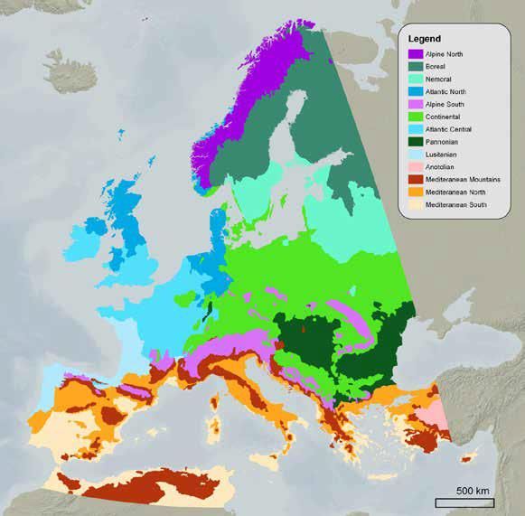
Authors’ affiliation:
Michelle Watson, Muséum national d’Histoire naturelle, MNHN (FR)
Gertie Arts, Wageningen Environmental Research, WENR (NL)
Anne Lyche Solheim, European Topic Centre on Inland, Coastal and Marine Waters, ETC/ICM (DE) /
Norwegian Institute for Water Research, NIVA (NO)

EEA project manager:
Eleni Tryfon, European Environment Agency (DK)

ETC/BD production support:
Muriel Vincent, Muséum national d’Histoire naturelle (FR)

Context:
The Topic Centre has prepared this Technical paper in collaboration with the European Environment
Agency (EEA) under its 2021 work programmes as a contribution to the EEA’s work on EUNIS habitat
classification.

Citation:
Please cite this report as
Watson, M., Arts, G. and Lyche Solheim, A., 2021. Revision of the EUNIS inland water habitat group -
Outcome of the expert workshop 16th March 2021. ETC/BD report to the EEA.
Disclaimer:
This European Topic Centre on Biological Diversity (ETC/BD) Technical Paper has not been subject to
a European Environment Agency (EEA) member country review. The content of this publication does
not necessarily reflect the official opinions of the EEA. Neither the ETC/BD nor any person or company
acting on behalf of the ETC/BD is responsible for the use that may be made of the information
contained in this report.

The withdrawal of the United Kingdom from the European Union did not affect the production of the
report.
Data reported by the United Kingdom are included in all analyses and assessments contained herein,
unless otherwise indicated.

©ETC/BD 2021
ETC/BD Technical paper N° 1/2021
European Topic Centre on Biological Diversity
c/o Muséum national d’Histoire naturelle
57 rue Cuvier
75231 Paris cedex, France
Phone: + 33 1 40 79 38 70
E-mail: http://bd.eionet.europa.eu
Website: https://www.eionet.europa.eu/etcs/etc-bd

   Revision of the EUNIS inland water habitat group                                             2
Contents
Contents ........................................................................................................................................ 3
Acknowledgements ....................................................................................................................... 4
Summary ....................................................................................................................................... 4
1     Introduction ........................................................................................................................... 5
2     Workshop overview ............................................................................................................. 10
3     Session 1: Standing waters .................................................................................................. 12
    3.1        Discussion .................................................................................................................... 12
      3.1.1        Main abiotic factors at Level 3 ................................................................................ 12
      3.1.2        Additional abiotic factors at Level 4 ........................................................................ 14
      3.1.3        Missing types to incorporate................................................................................... 15
      3.1.4        Distinction of Mediterranean region....................................................................... 15
      3.1.5        Placement of littoral habitats.................................................................................. 15
      3.1.6        Description of biological communities .................................................................... 16
    3.2        Main messages ............................................................................................................ 16
4     Session 2: Running waters ................................................................................................... 22
    4.1        Discussion .................................................................................................................... 22
      4.1.1        Main abiotic factors at Level 3 ................................................................................ 22
      4.1.2        Inclusion of flow at Level 4 ...................................................................................... 24
      4.1.3        Distinction of Mediterranean region....................................................................... 27
      4.1.4        Incorporation of floodplains and braided rivers ..................................................... 27
      4.1.5        Addressing temporarily flooded riparian zone ....................................................... 29
      4.1.6        Description of biological communities .................................................................... 29
    4.2        Main messages ............................................................................................................ 30
Overall conclusions ..................................................................................................................... 35
List of abbreviations .................................................................................................................... 36
Glossary ....................................................................................................................................... 37
References................................................................................................................................... 38
Annex 1 Agenda .......................................................................................................................... 42
Annex 2 Attendees ...................................................................................................................... 43
Annex 3 List of standing and running water body types considered for discussion. .................. 44

Revision of the EUNIS inland water habitat group                                                                                               3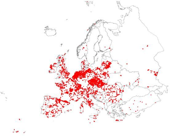
Acknowledgements
The participation of and contribution to the workshop is gratefully acknowledged:
Kamila Belka (ERCE/UNESCO), Antonio Camacho (University of Valencia), Laura Casella (ISPRA),
Milan Chytrý (Masaryk University), Douglas Evans (independent expert), Hugo Fontes (Institute
de recherche pour la conservation des zones humides méditerranéennes), Gary Free (CNR),
Tristan Hatton-Ellis (NRW), Seppo Hellsten (SYKE), Peter Kristensen (EEA), Chris Mainstone
(Natural England), Marit Mjelde (NIVA), Jose Antonio Molina (University of Madrid), Piotr
Parasiewicz (IRS), Leonard Sandin (NIVA), Joop Schaminée (WENR), Rafaela Schinegger (BOKU)
& Wouter van de Bund (JRC).
Additionally, the authors received further comments and material after the workshop from Chris
Mainstone, Tristan Hatton-Ellis, Laura Casella, Antonio Camacho, Gary Free and Milan Chytrý,
for which we are grateful.

Summary
The workshop on the revision of the EUNIS inland water habitat group of the EUNIS habitat
classification was organised by the European Environment Agency and its European Topic Centre
on Biological Diversity with support from the European Topic Centre on Inland, Coastal and
Marine Waters to further discuss the proposed revision of level 3 of the classification, to help
clarify the discriminating factors used at level 3 in order to proceed with the revision throughout
2021, and to discuss further biotic and abiotic discriminating factors to be used at level 4.
The main driver of inviting further discussions was the response to the Eionet and expert
consultation on the initial proposal held in May & June of 2019. The respondents indicated that
further clarification and revision of level 3 was needed as well as on how biological communities
would be addressed in the revision. An NRC EIONET webinar was held on December 8th 2020
with the aim to further explain the revision, provide examples of where biological communities
fit in the system and also to get more information from the Eionet countries. The outcomes of
these discussions, along with the comments received during the 2019 consultation, were used
as the basis of the expert workshop held on March 16th 2021.
A list of experts covering areas of inland water expertise needed to answer questions or fill in
gaps in the revision, was compiled. These areas concern expertise in particular habitats and
biological communities and the Habitats Directive and/or the Water Framework Directive or
both. Eventually, 18 external experts, apart from the organising team were available to
participate in the workshop. These experts come from 12 countries and 16 different universities
and national environmental agencies across Europe, spanning most geographical regions.

The workshop was divided into 3 parts:
Session 1 consisted of a series of presentations to set the context of both the revision and the
day ahead. The structure of the EUNIS habitat classification and the inland waters group in
particular was presented. The Broad Types derived from the national types established for the
Water Framework Directive were described. The background to the EUNIS inland water habitats
revision was presented along with more detailed level examples and data sources to extract
biological information.
Session 2 focussed on standing waters and presented both the main questions to be answered
and proposals for solutions. The topics for discussion centred on the Level 3 abiotic factors,

Revision of the EUNIS inland water habitat group                                                4
additional abiotic factors for Level 4, missing types, the distinction of the Mediterranean region,
the approach for descriptions of biological communities at level 4 and crosslinking to other
habitat typologies.
Session 3 focussed on running waters and described dynamics of running waters and the
crosslinking of running waters to other habitat typologies. The topics for discussion were the
main abiotic factors at Level 3, the position of ‘flow’ and other factors in the proposed structure,
how to define level 4 and lower levels, the distinction of the Mediterranean region, the
placement of floodplains and braided rivers in the wider EUNIS system, how to represent the
dynamics of river systems in the proposed structure and the description of biological
communities in running waters.

In general, new ideas and concepts were discussed in terms of alternative or additional
discriminating factors at both levels 3 and 4 which may be more appropriate or provide added
value. In some cases, it was found that suggested factors (e.g. Environmental Zones) were a
combination of discriminating factors already incorporated at level 3, or others (e.g. stream
power) were based on localised data and modelling which could not be extrapolated to a
European scale within the scope of this revision. However, these factors may be captured at
level 4 in the proposed system i.e. region or Environmental Zones can be captured if needed and
a current proposed system of describing riffles, runs and pools at level 4 captures elements of
flow and stream power. It was acknowledged that these factors could be considered for a future
revision of the system.

For standing waters, it was mainly concluded that ponds/pools would be included as a separate
group at level 3 due to their size and importance to regional biodiversity, timberline would be
used instead of treeline to distinguish between mid- to high altitude lakes and altitude and
latitude would act as a proxy for temperature. Geology as a discriminating factor at level 3
reflects the natural trophic status of the water bodies due to the relationship between geology
(alkalinity) and trophic status. There is no need to incorporate region/biogeographic region as a
discriminating factor at Level 3, since the distinctive factors (e.g. salinity, temporary hydroperiod
for Mediterranean standing waters) are already set at level 3. Helophyte habitats will be
included in the wetland habitat group, but will be associated with the descriptions of aquatic
habitats at level 4, when and where they occur. Isoetid communities (Littorelletea) are
considered aquatic. Marl lakes/karstic lakes will be identified as a separate habitat type at L3.

For running waters, more thought and discussion is needed as to where and how ‘flow’ is
incorporated into the structure. The current reference to flow is at level 4 with the description
of pools, riffles and runs. Region/biogeographic region does not need to be distinguished at level
3, floodplains and braided rivers will be considered as complexes and will be included as such in
the inland water habitat group.

1 Introduction
The EUNIS habitat classification is a comprehensive and extensive pan-European reference
system to harmonize and facilitate the description and collection of data across Europe through
the use of criteria for habitat identification (Davies and Moss 1999; Davies et al. 2004; Moss
2008, Rodwell et al. 2018). It is hierarchical, as shown below (Fig. 1), and covers all types of
habitats from natural to artificial, from terrestrial to freshwater and marine. It aims to
accommodate habitat types, ranging from highly aggregated types at the European level (Levels
1 to 3) to more detailed types identified at the regional and national levels (Levels 4 and lower).

Revision of the EUNIS inland water habitat group                                                  5
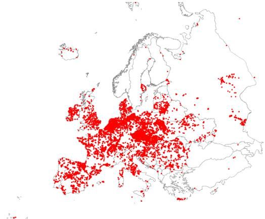
Figure 1. Indicative example of hierarchical structure of EUNIS habitat classification

Since its creation, EUNIS has undergone only modest change, but the increasing need to support
European policy on nature conservation with harmonised habitat descriptions ideally underpinned
by field data led to an initiation in 2012 of an extensive review of the EUNIS habitat classification.
For the approaches used to revise EUNIS habitats see Box 1. Habitat groups have been addressed
one by one since then including consultations with EIONET and external experts. Some revised
groups have been published in Chytrý et al. 2020. Whereas a floristic approach was considered
appropriate for terrestrial EUNIS habitats, which are largely defined by their vegetation, it was
agreed that a different approach was required for the marine and freshwater habitats.

For terrestrial habitats, the revised EUNIS habitat classification makes extensive use of
phytosociological data, which are available from initiatives such as the European Vegetation
Archive (EVA, Chytrý et al. 2016, http://euroveg.org/eva-database). Such data can be also useful
for inland water types as can be seen below (Fig. 2). Relevés for standing (18 170) and running
(8 847) waters, as well as helophyte vegetation (46 328) from the littoral zone are included and
available in the EVA database.

Figure 2. Relevés for standing and running waters (left) and helophytes (right), extracted from
the EVA November 30th 2020. 18,170 for standing and 8,847 for running waters, as well as
46,328 relevés for helophyte vegetation in the littoral zone

Revision of the EUNIS inland water habitat group                                                   6
However, as many typologies of rivers and lakes in Europe do not use floristics as the main
discriminating factor, it was decided to look into other existing European typologies that could
be used as the starting point, such as the Water Frame Directive types, which are based on a
limited number of abiotic discriminating factors (Lyche Solheim et al. 2019). As a broad typology
derived from the WFD common intercalibration types for lakes and rivers was also being
developed (ETC-ICM 2015, Lyche Solheim et al. 2019), it was decided to investigate the potential
for aligning those Broad types with the EUNIS revision. Various additional data sources can be
used to describe the biological communities of each habitat e.g. the EVA database for
vegetation, WISER database for species level information (phytoplankton, macrophytes, benthic
invertebrates, fish), and the various Intercalibration Technical Reports under the Water
Framework Directive with biological information based on a specific water body type e.g. a
highland, deep, calcareous lakes in the Alpine region. The following are intercalibration reports
describing other water body types: Solimini et al. 2014, Gassner et al. 2014, Pall et al. 2014,
Wolfram et al. 2014, Portielje et al. 2014 Böhmer et al. 2014, Sandin et al. 2014, Hellsten et al.
2014, Olin et al. 2014, Lyche Solheim et al. 2014, Kelly et al. 2014, Birk et al. 2018, Borics et al.
2018.

Using the discriminating factors from the broad types allows links to be made with Habitat
Directive Annex I habitat types (i.e. through the relationship between alkalinity and trophic state
referred to in the Annex I descriptions). To further describe lower level inland water habitats,
the European Red List descriptions can be used as a basis. There is already a strong relationship
between the Red List and EUNIS, and the Red List types will be linked to the broad types via
EUNIS. These linkages in typologies further connect EU nature and water policies.

It is important to note that while the proposed EUNIS structure at level 3 is based on the broad
type system, the broad types do not cover all water body types. As all types need to be
acknowledged in the EUNIS system, the proposed level 3 is a combination of the broad types,
previous EUNIS types not included in the broad types and additional types as a result of
discussions from the workshop.

The aim of the classification is to be a wall-to-wall classification where all inland water habitat
types can be placed. The habitats can be separated and identified by biological groups
(characteristic species or species groups) as well as by additional abiotic features at level 4 and
lower levels.

Revision of the EUNIS inland water habitat group                                                  7
Box 1: Approaches used to revise EUNIS habitat classification
 The EUNIS classification is revised down to level 3 through three different approaches:
     1) Floristic approach (main approach for terrestrial habitat types but also used in some
        marine and inland water types),
     2) Abiotic approach – substrate/depth zone/marine region (the main approach for
        marine benthic types),
     3) Abiotic approach – altitude/catchment size/geology/depth/flow (main approach for
        inland water types).
 Most of the habitats can be separated and identified by biological features (characteristic
 species or species groups for habitats following approach 1) at level 3 or 4.
 In an entire ecosystem, like a river system, a coastal area or a wetland, the relevant habitat
 types may have been revised through one, two or all approaches. It is necessary to look at many
 elements in order to have the full systemic perspective. For example:
 • For a river ecosystem, it would be necessary to select river type and flood plains from the
   inland water habitat group, gravel bars from the sparsely vegetated habitat group and,
   depending on the extent to which the ecosystem is being looked at, estuaries from the
   habitat complexes group. A floodplain might also include the grasslands in the floodplain
   from the grassland habitat group and the alder forests from the forest habitat group.
 • For a delta ecosystem, it may be necessary to select bog habitat (e.g. calcareous fens) types
   from the wetland habitat group, forest types (e.g. Salix alba and Populus alba galleries) from
   the forest habitat group, grasslands from the grassland habitat group and lakes/ponds and
   rivers/streams from the inland water habitat group.

The review of the inland waters group began in 2016 with a scoping study to compare the
current system with other European typologies: European Red List of habitats, Annex I habitats
under the EU Habitats Directive and the Broad Types derived from the Water Framework
Directive (ETC/BD 2016). Based on this, a first workshop was held in 2018 to look more closely
at how the current EUNIS system could be represented based on the typology factors used for
the Broad Types (ETC/BD 2018). A proposed structure was put to public consultation in 2019,
the outcome of which was an evident desire to further look at the structure and the factors used
to discriminate at level 3 (ETC/BD 2019). Due to Covid 19 and travel restrictions, an expert
workshop was delayed in the hope of holding an in-person meeting in 2021. An EIONET webinar
was held in December 2020 to further explain the proposed structure and to establish if and
how EUNIS is used in the Eionet countries (ETC/BD 2021). Eventually, a virtual workshop was
held on March 16th 2021 (Fig. 3). The agenda of the workshop can be seen in Annex 1. The
revision of EUNIS inland water habitat group will be developed from EEA, ETC/BD and ETC/ICM
based on the outcomes of the studies and meetings mentioned above.

Revision of the EUNIS inland water habitat group                                             8
Figure 3. Timeline of revision of EUNIS inland water habitat group
The principles of the proposed EUNIS surface waters revision prior to holding the expert
workshop were:
1. To broadly align the EUNIS inland waters at level 3 with the Broad Types developed from
Lyche Solheim et al. 2019, which are derived from the intercalibration types of the
Water Framework Directive;
2. To cover other inland water habitats by adding further types where the Broad types do
not cover water body types identified in the countries;
3. To include underground inland water bodies that are not considered in the current
EUNIS inland water habitats;
4. To add smaller water bodies that are not covered by the broad types;
5. To use geology (alkalinity) as a proxy for trophic state as a parameter to describe the
water bodies’ natural (pristine or unimpacted) state;
6. The revision should capture differences in all biological communities, not just
vegetation, where there is a clear difference in at least one part of the taxonomic
assemblages (e.g. fish, benthic algae, macrophytes, macroinvertebrates, phytoplankton,
zooplankton), this may constitute a different habitat.
Revision of the EUNIS inland water habitat group 92 Workshop overview
Careful consideration was put into the identification of experts for coverage of the areas needed
to answer questions or fill in gaps in the revision. These areas concern expertise in particular
habitats and biological communities and to the Habitats Directive and/or the Water Framework
Directive or both in addition to expertise with inland waters across geographical regions of
Europe. Eventually, 18 external experts, apart from the organising team were available to
participate in the workshop from 12 countries and 16 different universities and national
environmental agencies (Annex 2) across Europe.
The aims of the workshop were to:
• Clarify rationale behind the proposed structure consulted on in 2019,
• Address concerns arising out of the consultation and the EIONET webinar,
• Engage experts with a diverse background covering as many areas of freshwater ecology
as possible,
• Get further guidance and direction on proceeding with the level 3 structure,
• Present and discuss proposed level 4 discriminating factors,
• Establish the appropriate placement of other abiotic factors to both standing and
running water habitats,
• Investigate further biological data sources to be exploited.
Introduction
Eleni Tryfon (EEA) presented an ‘Overview of the EUNIS habitat classification and European
classifications and typologies’, describing the structure of the EUNIS classification system (i.e.
levels 1 to 3), the features of the classification system, progress with the revision, the structure
of the current EUNIS inland water habitat group, challenges and issues with the current structure
and other inland water habitat typologies.
Anne Lyche Solheim (ETC/ICM – NIVA) presented ‘Broad European Types of Lakes and Rivers:
Rationale, identification and application’. This presentation looked at common issues between
the EU Habitats Directive and the Water Framework Directive, ways to align the Habitats
Directive and EUNIS inland water types with the Broad Types derived from the WFD, a
description of how the Broad Types were derived, including the descriptors used, and a
justification for the broad types as an ecologically relevant basis for the EUNIS revision.
Michelle Watson (ETC/BD – MNHN) presented the ’Revision of EUNIS inland water classification’
which detailed the background to the EUNIS inland water habitat revision, the development of the
proposal including the changes between the current and the proposed structure and the final
proposed list of standing and running water types, issues with the current littoral habitat group,
the proposed descriptions of biological communities at level 4, the outcome of the EIONET
webinar and data sources to be exploited to describe biological communities at lower levels.
Session 1 – standing waters
Anne Lyche Solheim (ETC/ICM – NIVA) led the discussion on the standing waters session. The
discussion was loosely based around the following questions:
1. Do you agree with the main abiotic typology factors proposed for level 3?
-If not, should one or more of these factors be supplemented or replaced by others?
Revision of the EUNIS inland water habitat group 10-If yes, which factors and why?
2. Do you agree with the additional abiotic factors proposed for level 4 (size and depth)?
- If not, should one or more of these factors be supplemented or replaced by others?
- If yes, which factors and why?
3. Are some important habitat types still missing from the proposal in order to encompass
your specific types at the lower levels?
4. Do you support the distinction of the Mediterranean region as a separate geographical
region or is that not needed if brackish/saline and temperate lakes/ponds are added at
level 3? Do you agree that the other regions are merged at level 3, and can be further
specified at more detailed EUNIS levels?
5. Would you agree that the helophyte vegetation could be moved to a revised Wetlands
section?
6. Would you agree with the proposed approach for descriptions of the biological
communities at level 4 (using European datasets, e.g. WISER or EVA database, WFD
intercalibration Technical Reports). Are there other databases of use here?
Session 2 – running waters
Gertie Arts (ETC/BS – WENR) led the discussion on the running waters session. The discussion
was loosely based around the following questions:
1. Do you agree with the main abiotic typology factors proposed for running waters at
level 3 (altitude, geology, catchment size)?
2. Should flow be included at level 3 or 4? And if at level 3, should it be an additional
factor or a replacement?
3. Do you support the distinction of the Mediterranean region as a separate
biogeographic region?
4. Should floodplains and braided rivers be added to Habitat complexes or to Sparsely
vegetated land sections, or be included in the running waters?
5. How to accommodate the dynamics of river systems?
6. Where to include the riparian zone that is temporarily flooded?
7. Description of biological communities.
The main themes of the sessions are described in Section 3. As the discussions overlapped
several of the themes identified in the proposed questions, these have been summarised by
theme rather than chronologically. For the list of standing water and running water types
proposed for discussion in the workshop please refer to Annex 3.
Revision of the EUNIS inland water habitat group 113 Session 1: Standing waters
3.1 Discussion
Below is a summary of the main discussions on standing waters during the workshop. In general,
it was accepted that the proposed level 3 abiotic factors work well for standing waters. It was
noted that the concept of ‘reference condition’ from the Water Framework Directive typology
was important as EUNIS needs to describe habitat types in their natural condition. It was also
argued that the use of the trophic status should not be used as a classification factor as it may
commonly result from anthropogenic eutrophication pressures rather than from natural causes.
It was noted that for a habitat to be distinguished from another at least part of the characteristic
species must be different, otherwise it will result in overlapping habitats. It was discussed that
there was a need for pragmatism when choosing the discriminating factors at level 3. For other
topics discussed no clear agreements were made.
While the discussions below for standing waters are separated into different headings and sub-
headings, some of these themes and topics overlapped each other during the workshop.
Additionally, where themes were common between standing and running waters (e.g. alkalinity,
geology) these are discussed in detail only once in the report.
3.1.1 Main abiotic factors at Level 3
Do you agree with the main abiotic typology factors proposed for level 3?
- If not, should one or more of these factors be supplemented or replaced by others?
- If yes, which factors and why?
Size:
It was decided that ponds & pools should be added as a separate type at level 3. This is to give
this particular water body type more visibility in the hierarchy. It was proposed to distinguish
ponds & pools with an area ofMediterranean countries and Eastern European countries (Phillips et al. 2013). Further evidence of this positive relationship is given by paleo-ecological data in UK lakes (Bennion and Simpson 2011). These lines of evidence are the basis for the identification of alkalinity ranges in different broad types, which also reflect equivalent ranges used in the WFD common intercalibration types for describing biological reference conditions and class boundaries for WFD high and good ecological status. There were several discussions, both in the workshop and through correspondence with experts afterwards, about the nature of this relationship and its strength across all European lake types. One of the workshop participants commented that there is no fundamental reason for a high alkalinity lake to have a high phosphorus concentration and this was demonstrated in a study from the 1980s in the Canadian shield lakes (D’Arcy & Carignan, 1997) where high phosphorus concentration was due to catchment size and the residence time of phosphorus in soils rather than a high alkalinity concentration. The positive relationship between alkalinity and phosphorus was seen as being mostly statistical without a clear reason as to why such a relationship should exist. After the workshop, the chair of the standing waters session suggested that one possible reason may be that the dominating mineral for phosphorus in natural catchments is apatite, which are calcium-phosphate compounds [Ca₁₀(PO₄)₆(OH)₂, Ca₁₀(PO₄)₆F₂ and Ca₁₀(PO₄)₆Cl₂]. Another reason can be the relatively high content of alkalinity and phosphorus found in marine deposits, which are dominating the catchments in lowland areas of Nordic lakes, due to the land uplift after the last glaciation. In an ad-hoc meeting with experts after the workshop, there was further discussion about the applicability of this relationship to Mediterranean lakes in particular. The positive relationship between alkalinity and total phosphorus (natural trophic status) as demonstrated via the REBECCA and WISER projects included Mediterranean reservoirs, but did not include natural lakes from the Mediterranean region. Mediterranean lakes with moderate or high alkalinity can sometimes have quite low phosphorus concentration (= naturally oligotrophic state) due to co- precipitation of phosphorus with CaCO3 (but they are not considered to be marl lakes). These Mediterranean lakes either need to be identified as a separate type at level 3 or to be captured at level 4, as a subtype of calcareous lakes to ensure that the Mediterranean natural lakes with high alkalinity and low phosphorus can also fit within the system. The positive relationship between alkalinity and phosphorus, as described above, does not apply to karstic or marl lakes. Such lakes have very high alkalinity combined with low phosphorus concentrations due to phosphorus being co-precipitated with calcium-carbonate (e.g. Danen- Louwerse et al. 1995). Karstic lakes are to be included as a separate type at level 3. Altitude: The upper altitude limit is denoted by the treeline in the proposed structure however it was suggested to use the timberline instead. The timberline is a limit beyond which the change in climate is evident. This would also capture the changes seen when moving from South to North in latitude. The altitude threshold of 200m between low and mid altitude lakes was also supported from a Central European point of view. Latitude is important to consider in order to account for the change from a cold/wet oceanic climate in North-Western Europe to a warm and dry Continental or Mediterranean climate in South-Eastern Europe. Revision of the EUNIS inland water habitat group 13
It was discussed whether temperature could be a better discriminating factor than
altitude/latitude. However, temperature is a complicated variable to incorporate in terms of
what to measure (air or water), how it needs to be measured (min, max, over what time period)
and how to obtain this information. This applies to running waters as well. Altitude/latitude is
seen as a proxy for temperature.

3.1.2 Additional abiotic factors at Level 4

   Do you agree with the additional abiotic factors proposed for level 4 (size and depth)?
   - If not, should one or more of these factors be supplemented or replaced by others?
                               - If yes, which factors and why?

Size:
The placement of ‘ponds’ in the proposed structure was discussed in detail. By strict definition,
ponds are a very different habitat to lakes. Lakes are dominated by fish communities,
phytoplankton, zooplankton. Ponds can sometimes be without fish and therefore invertebrates
or amphibians can be top predators, along with phyto- and zooplankton. This difference should
be captured in the typology, an option is to include ponds as a separate category to lakes at level
3.

It was agreed that
3.1.3 Missing types to incorporate
Are some important habitat types still missing from the proposal in order to encompass
your specific types at the lower levels?
Marl lakes are a separate type to be included. This will be captured at level 3 under ‘karstic
lakes’.
Volcanic lakes will also be their own separate group at level 3. There is much difference between
Macaronesian, Icelandic and Mediterranean volcanic lakes, this will be distinguished at level 4.
3.1.4 Distinction of Mediterranean region
Do you support the distinction of the Mediterranean region as a separate geographical
region or is that not needed if brackish/saline and temperate lakes/ponds are added at L3?
Do you agree that the other regions are merged at L3, and can be further specified at
more detailed EUNIS levels?
As both saline and temporary water bodies are included at level 3, there is no need to distinguish
the Mediterranean region at this level. Regional distinction can be at lower levels if it’s useful.
3.1.5 Placement of littoral habitats
Although isoetids can be considered amphibious vegetation in very small water bodies (ponds
and pools) in the Atlantic and Mediterranean regions, they are submerged and truly aquatic in
most of the other lake habitats in all regions, and are therefore considered as aquatic vegetation
to stay in the inland waters group. The amphibious nature of isoetids in ponds and pools can be
described at level 3 or level 4.
Would you agree that the helophyte vegetation could be moved to a revised Wetlands
section?
An argument to keep the helophytes in the inland water section is that they are already an
essential part of WFD assessment of ecological status for macrophytes in lakes e.g. in Spain
(Camacho et al. 2019), and also in Finland and Poland. They are very sensitive to pressures i.e.
water level regulation, other hydromorphological pressures, eutrophication pressures etc. and
are therefore good indicator species in terms of assessment of ecological status under the WFD.
It was noted that whichever habitat group the helophytes are placed, they can be linked to the
appropriate inland water habitats in terms of their descriptions i.e. at level 4. These descriptions
can also refer to the functional importance of a habitat to an ecosystem and to other EUNIS
habitat groups. It was discussed that helophytes are not always related to water bodies. They
often occur in wet depressions distant from water bodies and their ecology is more similar to
Revision of the EUNIS inland water habitat group 15that of mires rather than the aquatic environments (actually they often represent an initial stage
of mire succession).
3.1.6 Description of biological communities
Would you agree with the proposed approach for descriptions of the biological
communities at level 4 (using European datasets, e.g. WISER or EVA database, WFD
intercalibration Technical Reports)? Are there other databases of use here?
Additional data sources were not identified.
3.2 Main messages
Although the main discussions covered many topics, below is a summary of the main points in
relation to the original topic questions asked. While some conclusions were reached on some
topics, there are still some topics that needed further discussion. These are listed in the column
‘General outputs from workshop’.
Revision of the EUNIS inland water habitat group 16Table 1. Summary of the main topics discussed during the workshop for the standing water bodies Main abiotic factors at Level 3 Topic discussed Details General outputs from workshop Ponds/pools to be Ponds are a very different habitat to lakes (e.g. they can be Ponds will be kept as a separate group at L3. included as a represented more by invertebrates as the top predators in the Also, to include ‘pools’ in the title as this will capture the separate group at L3 absence of fish, used more by amphibians). smallest inland standing water bodies. Upper size limit
Water bodies with small surface areas may also have a wide
                      range of depth e.g. Annex I habitats 3190 Lakes of gypsum karst.
                      Depth is already considered as a discriminating factor at L4.
Delineation of the As the climate clearly gets harsher above the timberline it was Timberline is more appropriate and this will be used instead of
boundary for high- suggested to use this as the delineation of high-altitude treeline.
altitude water bodies waterbodies rather than the treeline.

                     The difference being that treeline means the upper limit of single
                     individual trees, while the timberline is the upper limit of forests.
Threshold between There was general agreement that this an acceptable limit (also 200m is appropriate for delineation between low-mid-altitude
low and mid-altitude from a Central European perspective).                                 water bodies.
waterbodies - 200m

Temperature as an Temperature by itself will not be included as a separate factor as Temperature by itself will not be included as a separate factor.
independent           it is often difficult to obtain this information (i.e. should be water
discriminating factor temperature and not air temperature) and it varies a lot in space
                      (at a scale of a few km2 depending on local topography and
                      size/depth of the lake) and time (at a scale of hours) and it is too
                      difficult to get access to the data.

                        Altitude/latitude is a good proxy for temperature so it is not
                        needed as a discriminating factor.
Alkalinity        (i.e. It was discussed whether the relationship between alkalinity and   Geology (i.e. alkalinity) is retained as a discriminating factor at
geology)     as       a nutrient concentration was statistical rather than there being a   L3 as a relationship between total phosphorus (natural trophic
discriminating factor fundamental reason for this relationship.                            state) and alkalinity has been shown in reference lakes (Lyche-
                        This relationship (i.e. between low/high alkalinity and low/high   Solheim et al. 2006, 2008, Phillips et al. 2008, Bennion and
                        phosphorus) was shown in reference lakes (REBECCA and WISER        Simpson 2011). This allows a link between the revised EUNIS
                        projects, as well as from paleolimnology), but does not apply to   habitats and the HD Annex I habitat types.
                        marl-lakes, karstic lakes where the alkalinity is extremely high
                        (because the phosphorus is naturally low due to co-precipitation   The positive relationship between alkalinity and total
                        with CaCO3).                                                       phosphorus may not apply to all Mediterranean waterbodies.

  Revision of the EUNIS inland water habitat group                                            18
Therefore, the system should enable these types to also be
It has been shown, in Scandinavia, where the majority of reflected either as a separate type at L3 or a sub-type of
European lakes are found, the reason for this relationship is that calcareous lakes at level 4.
the bedrock is often siliceous and the natural P-concentration is
very low (< 5 µg/l), while in areas in the lowlands where there are
marine deposits (after the last glaciation), the soils have higher P-
concentration and provide naturally more fertile areas, and lakes
with higher natural P-concentration (the marine deposit-line is
ca. 200 m altitude in Eastern Norway and Southern Sweden and
Southern Finland). Marl-lakes and karstic lakes are proposed as
separate types at L3.
Separately, it was discussed that this relationship may not apply
to some Mediterranean water bodies e.g. calcareous lakes with
low phosphorus concentrations. A system whereby alkalinity
ranges are referred to in level 4 rather than at level 3 may be a
way to ensure this current system is retailed while allowing these
specific lake types to be included in the system.
Additional abiotic factors at Level 4
Topic discussed Details General outputs from workshop
Area as a Water body size (surface area) is important for biodiversity and is Further discussion is needed concerning finer divisions of size
discriminating factor appropriate to be included at L4. at L4 for ponds/pools (see the first row on ‘Main abiotic factors
Ponds/pools are captured as a separate group at L3. at Level 3’ above).
This subdivision depends on whether differences in biological
2
Very large lakes (> 100 km ) are also identified as a separate type communities can be identified at further size classes.
at L3 due to their huge water volume and very long retention
time.
Revision of the EUNIS inland water habitat group 19Depth as a It was agreed that depth was an important factor for Depth and water retention time to be included at L4. Depth
discriminating factor discriminating between standing water body types due to increments were suggested but not decided upon. Ponds will
stratification and mixing patterns influencing the functioning of also be further divided by depth at L4.
the lake and its biological communities. Its placement at L4 is
appropriate.
Depth was previously included at L3 in an earlier version of the
structure. However, based on the multiple depth classes to be
considered this resulted in a large number of types at L3,
therefore depth was moved to L4.
Water retention time is also described alongside depth at L4.
Distinction of Mediterranean region
Topic discussed Details General outputs from workshop
Inclusion of the Saline and temporary lakes are represented at L3, which is Region is not to be included at L3, but may be considered at L4.
Mediterranean sufficient to distinguish the Mediterranean region water bodies.
region at L3. Regions can be included at lower levels if needed.
The Metzger (2012) ‘Environmental Zones’ (i.e. climatic zones) is
another factor which could be included at lower levels instead of
region (if needed).
Missing types to incorporate
Topic discussed Details General outputs from workshop
Marl/karstic lakes to To be included as a separate group at L3 (see the L3 row on To be included as a separate group at L3.
be included as a alkalinity above).
separate group at L3
Volcanic lakes to be These lakes have a different water chemistry to other standing To be included as a separate group at L3.
included as a water bodies in the proposed structure.
separate group at L3 There are also regional differences i.e. between Icelandic,
Macaronesian and Italian volcanic lakes. These will be
distinguished further at L4.
Revision of the EUNIS inland water habitat group 20Placement of ditches It was not decided if ditched should be kept in standing or running No decision is made on the placement of ditches.
waters. It was suggested to include these in the title of ‘ponds’ at
L3 if kept in the standing water group.
There was opposition to including then in the EUNIS system at all
as it was noted that the system needs to describe natural habitats
which would not include ditches.
Placement of littoral habitats
Topic discussed Details General outputs from workshop
Isoetids species to It is noted that in the Mediterranean, Isoetes histrix is found on Isoetids are indicator species that are sensitive to
describe aquaticwet outcrops in spring and live in dry soil for most of the year. eutrophication and should be kept as aquatic vegetation and
communities Isoetids in both the Atlantic and Mediterranean regions can be described in the inland standing water habitats.
amphibious in very small lakes, ponds and pools. However, in
other lake types, the isoetids are more submerged.
Helophytes to be This proposal is based on reed beds often occurring separately Helophytes to stay in the wetland habitat group.
included in wetlands from water bodies i.e. wetland depressions in the landscape. If
these are included only in the inland waters, it will result in many
non-aquatic habitat types. Finland and Poland use these as part
of WFD ecological status assessment for macrophytes in lakes
and would prefer to keep them in inland waters.
It was suggested to move the helophytes to the wetland habitat
group and refer to it in the inland water habitats descriptions.
Placement of This is still an ongoing discussion in relation to the revision of the To be further investigated in conjunction with the discussion on
amphibious habitats EUNIS wetland habitats group. helophyte habitat placement.
Revision of the EUNIS inland water habitat group 214 Session 2: Running waters
4.1 Discussion
Below is summarised the discussions from the workshop on running waters. Clear decisions or
agreements were not made for all topics discussed. In general, it was discussed that variables
driving the form and function of river habitats should be more evident at level 3 e.g. a factor to
measure the energy of the water course and its ability to move sediment around. This should
also reflect the dynamics of the systems. It was discussed that describing at level 3 anything
beyond what is already used is too detailed e.g. stream power, flow etc. The issue with
describing flow in the EUNIS system is that it changes with location and with time, there many
ways to define and measure flow-related variables (i.e. different variables, e.g. current velocity,
slope, flow, gradient, level of braiding or meandering). Flow dynamics should be incorporated
into the system in a way that can be measured and observed at a pan-European scale. Another
problem with flow-related variables is that they are often modified by man due to
hydromorphological alterations (e.g. hydropower, transport, urbanisation, drainage).
It was noted from one participant that EUNIS needs to inform biodiversity policy whereas the
Broad Types inform water policy. The European Red List of habitats was suggested as a good
starting point to describing inland water habitats at a lower level. As there is already a strong
relationship between the Red List and EUNIS, incorporating the Red List allows for a link to be
made with the broad types, which further allows EU nature and water policies to be linked. The
Broad Types are based on purely natural abiotic factors that are important to explain natural
biological variability.
While the summary of discussions below is separated into different headings, many of these
themes and topics overlapped each other during the workshop. Additionally, where themes
were common between standing and running waters (e.g. alkalinity, geology) these are
discussed in detail only once in the report (i.e. in Section 3 above).
4.1.1 Main abiotic factors at Level 3
Do you agree with the main abiotic typology factors proposed for running waters at level
3 (altitude, geology, catchment size)?
Environmental Zones:
It was discussed which ‘climate’ element was most appropriate to incorporate at level 3. The
Metzger et al. 2012 ‘Environmental Zones of Europe’ was suggested as a discriminating factor
to include at Level 3 (Fig. 4). The zones are based largely on the parameters described at level 3
e.g. geology as well as the climatic components, which have a direct relationship to the flow.
They are represented by a composite measurement linked to each zone. This factor was also
useful as a descriptor of habitat types in the AMBER project in conjunction with slope, catchment
size, geological classification, Strahler order.
Revision of the EUNIS inland water habitat group 22Figure 4. Metzger et al. (2012) showing the ‘Environmental Zones of Europe’ Shape/form: It was discussed that an indicator of size (form and shape) is needed at level 3. Catchment area, which is already accounted for, can capture the size of a river system. The opposite view was also presented i.e. that other factors, such as climatic factors (e.g. Environmental Zones) should be represented at level 3, with factors describing shape and form at lower levels. Level 4 in the proposed structure describes riffles, pools and runs, which describe the form and function of a river system. However, this system is considered as too fine a scale to be described at this level i.e. a riffle and a pool can occur a few meters away from each other. The UK is investigating GIS modelling to describe form, in very general terms, across reaches of rivers (see Box 2 in section 4.1.2 below). It was suggested that the Environmental Zones could be incorporated at level 3 or level 4, as biogeography is already incorporated. It was suggested that geology is better described at level 4 i.e. to have an abiotic, physical, functional typology at level 3, then water chemistry and other variables at level 4. However, it has been shown that factors such as geology (alkalinity), altitude and catchment size, stream order, are relatively good descriptors of biological relationships at a coarse scale (and also reflected in the Environmental Zones). Additionally, the parameters used need to be independent of human influence, an example of this is altitude and geology and catchment size. Factors like flow and stream power are not free of human influence. Revision of the EUNIS inland water habitat group 23
4.1.2 Inclusion of flow at Level 4
Should flow be included at level 3 or 4? And if at level 3, should it be an additional factor
or a replacement?
Flow:
Flow is an important factor to include when describing a river system as it is a way of capturing
the hydraulic energy in the river system that is responsible for shaping it i.e. through moving and
redistributing sediment and hence largely determining the geomorphological form of the river.
It was discussed that to consider hydraulic energy there is a need to consider flow as well as
current velocity, and that the pattern of flow velocity and its amplitude (high versus low velocity)
is more important than the mean or average velocity. Whereas ‘flow’ is an indication of river
size, ‘velocity’ is ‘something that organisms experience’.
However, as flow is subject to human interference, this makes it difficult to incorporate in the
system e.g. altering flow for dams, irrigation etc. While it was noted that direct measurements
of flow are very detailed to incorporate at level 3, it was suggested that modelling flow could be
an option. A system whereby GIS modelling can be used to generate unimpacted reference
conditions (a necessity of describing habitats in the EUNIS system) could be considered in the
future. Such a system is being developed in the UK (please see Box 2 in ‘Stream power’ below).
However, this would require access to Europe-wide datasets, which are not available at the
moment. This analysis is also beyond the scope of this revision.
The proposed structure as it stands includes a more simplistic reference to river flow at level 4
in the form of riffles, pools and runs (described in more detail in ‘Dynamics & scale’ below).
‘Stream power’, related to flow and velocity, is described in more detail below.
Stream power:
‘Stream power’, which is currently used in predictive modelling in the UK (with the aim of
predicting habitats at different scales), was discussed as a possible discriminating factor at level
3. The modelling looks at the changes in reference stream power on a longitudinal basis along
the entire river network and aims to relate this to changes in habitat character (using the
geomorphic types of the Red List of habitats). It can be use to describe the shape of the habitat,
the impact of hydraulic energy on redistributing river sediment thereby describing the
functioning of a river system. It can also capture climate and catchment information.
In more detail, the GIS modelling aims to predict the likelihood of a specific reach of river of
having a specific flow and substrate, such as high current velocity with big stable substrate, low
velocity with finer substrates etc. This gives a picture of how sediment is generated and how it
is moved around a river system.
The modelling process accounts for artificial factors as much as possible i.e. where natural flow
is manipulated. However, the dataset would need to be modelled across Europe to be useful in
this context. See Box 2 below for more information on using stream power in the UK context.
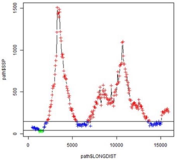
Revision of the EUNIS inland water habitat group 24Box 2: A UK perspective on abiotic characterisation of the European Red List river/stream
typology and its relevance to the EUNIS review
The Red List typology includes a small set of hydraulic/geomorphic river/stream types from
EUNIS Level 3 that provides a holistic basis for describing habitat character which relates to
distinctive biological assemblages. Variations in habitat generated by water chemistry
(particularly alkalinity/hardness) can be seen as a secondary source of variation, often
involving the substitution of related species according to water chemistry preferences.
Key river/stream types are as follows:
• Red ListC2.2a Permanent non-tidal, fast, turbulent watercourse of montane to
alpine regions with mosses
• Red ListC2.2b Permanent non-tidal, fast, turbulent watercourse of plains and
montane regions with Ranunculus spp.
• Red List C2.3 Permanent non-tidal, smooth-flowing watercourse
• Red List C2.4 Tidal river, upstream from the estuary.
To this list can be added dynamic gravel-bed rivers or ‘active shingle’ rivers, which are
currently only included in the Red List typology as riparian habitats.
Some of these types have strong relationships with Habitats Directive Annex I river types such
as watercourses with Ranunculion /Batrachian vegetation (H3260) and alpine rivers.
On-going modelling work in the UK is looking at how the natural spatial distribution of these
types can be predicted across the UK using environmental variables, with the aim of providing
a simple basis for characterising key variations in habitat provision within rivers/streams.
Modelled distributions can be used to help report on the condition of these different river
types (for example by filtering relevant Water Framework Directive data), stratify monitoring
regimes and plan conservation strategies. Further modelling work is planned to model the
distribution of other Red List river/stream types.
There are various abiotic variables that can be used in this kind of prediction, all relating to
hydraulic energy and the ability of river and stream channels erode and deposit sediments of
varying coarseness (from boulders all the way down to silts). Any such modelling has to take
account of the nested spatial scales of habitat variation inherent in river systems. The aim is
to characterise general habitat
character at the large-reach scale
(of the order of a few kilometres),
accepting that there will be smaller
scale habitat variation within
reaches.
The analysis has focused on stream
power as a derived attribute that
reflects the contribution of a
number of environmental variables
to the hydraulic energy of a
river/stream section. There are
issues with generating estimates of
stream power that are free of
anthropogenic influence, but
analytical options have been
Figure 1. Modelling ‘natural’ longitudinal variation in chosen to be as free of human
stream power along the river/stream network (colours modification as possible. A simple
Revision of the EUNIS inland water habitat group 25You can also read