Sedimentology, petrography, and reservoir quality of the Zarga and Ghazal formations in the Keyi oilfield, Muglad Basin, Sudan - Nature
←
→
Page content transcription
If your browser does not render page correctly, please read the page content below
www.nature.com/scientificreports
OPEN Sedimentology, petrography,
and reservoir quality of the Zarga
and Ghazal formations in the Keyi
oilfield, Muglad Basin, Sudan
Yousif M. Makeen1*, Xuanlong Shan1, Habeeb A. Ayinla2, Ekundayo Joseph Adepehin3,
Ndip Edwin Ayuk4, Nura Abdulmumini Yelwa5, Jian Yi1, Osman M. A. Elhassan6 & Daijun Fan1
The Zarga and Ghazal formations constitute important reservoirs across the Muglad Basin, Sudan.
Nevertheless, the sedimentology and diagenesis of these reservoir intervals have hitherto received
insignificant research attention. Detailed understanding of sedimentary facies and diagenesis could
enhance geological and geophysical data for better exploration and production and minimize risks.
In this study, subsurface reservoir cores representing the Zarga formation (1114.70–1118.50 m
and 1118.50–1125.30 m), and the Ghazal formation (91,403.30–1406.83 m) were subjected to
sedimentological (lithofacies and grain size), petrographic/mineralogic (thin section, XRD, SEM), and
petrophysical (porosity and permeability) analyses to describe their reservoir quality, provenance, and
depositional environments. Eight (8) different lithofacies, texturally characterized as moderately to
well-sorted, and medium to coarse-grained, sub-feldspathic to feldspathic arenite were distinguished
in the cored intervals. Mono-crystalline quartz (19.3–26.2%) predominated over polycrystalline quartz
(2.6–13.8%), feldspar (6.6–10.3%), and mica (1.4–7.6%) being the most prominent constituent of
the reservoir rocks. Provenance plot indicated the sediments were from a transitional continental
provenance setting. The overall vertical sequence, composition, and internal sedimentary structures
of the lithofacies suggest a fluvial-to-deltaic depositional environment for the Ghazal formation,
while the Zarga formation indicated a dominant deltaic setting. Kaolinite occurs mainly as authigenic
mineral, while carbonates quantitatively fluctuate with an insignificant amount of quartz overgrowths
in most of the analyzed cores. Integration of XRD, SEM, and thin section analysis highlights that
kaolinite, chlorite, illite, and smectite are present as authigenic minerals. Pore-destroying diagenetic
processes (e.g. precipitation, cementation, and compaction etc.) generally prevailed over pore-
enhancing processes (e.g. dissolution). Point-counted datasets indicate a better reservoir quality
for the Ghazal formation (ɸ = 27.7% to 30.7%; K = 9.65 mD to 1196.71 mD) than the Zarga formation
(17.9% to 24.5%; K = 1051.09 mD to 1090.45 mD).
The Muglad Basin is a rift basin and an important hydrocarbon province in northern Africa. It extends about
300 km wide and 1200 km long cutting across the Republic of Sudan and the South Sudan. Hydrocarbon dis-
covery and exploration in the Muglad Basin started in the early 1970s and spans to 1980s and present. The Fula,
Heglig and Unity oilfields (Fig. 1) were the first to be discovered during early exploration activities carried out
by Chevron O il1,2. Although, the sedimentary thickness at the basin’s depocenter is estimated to be 13.7 km,
the maximum drilled thickness in basin is generally < 4.5 km depth penetrating mainly lacustrine and fluvial
deposits1,3–9.
Over the years, the Muglad Basin has attracted substantial exploration/research activities being the main
hydrocarbon province in the Republic of Sudan and South Sudan. Early exploration activities include; Aerial
photography, Landsat images, airborne magnetometer, helicopter supported gravity survey and detail seismic
survey carried by Chevron Oil between 1974 and 19761 defining the basin dimension and identifying potential
1
College of Earth Sciences, Jilin University, Changchun 130061, China. 2Department of Geology, Federal
University Lokoja, P. M. B 1154, Lokoja, Nigeria. 3Department of Geology, National University of Malaysia,
Bangi, Malaysia. 4Pan African University‑Life and Earth Science Institute, University of Ibadan, Ibadan,
Nigeria. 5Department of Geology, University of Malaya, 50603 Kuala Lumpur, Malaysia. 6Harquail School of Earth
Sciences, Laurentian University, Sudbury, Canada. *email: makeen.geo@hotmail.com
Scientific Reports | (2021) 11:743 | https://doi.org/10.1038/s41598-020-80831-y 1
Vol.:(0123456789)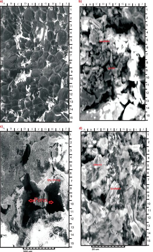
www.nature.com/scientificreports/
Figure 1. Location of map showing the Keyi oilfield, Northeastern region of the Muglad Basin, Sudan. It also
shows the main oilfields discovered, major fault and block boundary (created using CorelDRAW Graphics Suite
2018 v20.0.0.633 https://www.corel.com/cn).
petroleum structure and play. The stratigraphic column of the Muglad Basin have been divided into the Precam-
brian basement, the Upper Jurassic/Lower Cretaceous to Tertiary strata and the Tertiary to Quaternary sediments
by (Fig. 2, Table 1)1,10,11. The lacustrine and/or floodplain shales of the lower Cretaceous non-marine Abu Gabra
formation regarded as the major source rocks in the entire Muglad Basin (Figs. 2, 3, Table 1). The sandstones
within the Bentiu, Aradeiba, Zarga and Ghazal formations represent the main reservoir intervals (Table 1). These
reservoirs are sealed by overlying mudstone of the Darfur Group (Fig. 2). A chronicle of published literature in
the Muglad Basin shows that extensive studies have been carried out on the organic richness of the source rocks
in the basin, kerogen types have been determine as well, maturity, oil-source rock correlation and hydrocarbon
generative potential of the Abu Gabra formation have been studied in details4–9,12–15.
The Zarga and Ghazal formations in the Muglad Basin have been identified as topmost reservoir horizons.
These formations contain sandstone, siltstone, mudstone and shale lithologies, thus act as both reservoir and seal
asin1,3,16. However, detailed investigation on the sedimentology, diagenesis and reservoir quality
in the entire b
of the Zarga and Ghazal formations are yet to be carried out. This paper presents findings of an integrated sedi-
mentary facies analysis, paleodepositional environment, petrographic analysis and petrophysical assessment of
the two formations relating to their potential as petroleum reservoir.
Geological setting. The evolution of the Central and Southern Sudanese basins began in the upper Jurassic
to lower Cretaceous time was as a result of the tectonic processes that took place within the central and western
continental margins of the African plate1,7,8. This is associated with the opening of the South Atlantic Ocean dur-
ing the C retaceous7,14,17. These processes occasioned the formation of the Central African Shear Zone (CASZ),
which led to the development of the sedimentary basins in Sudan and its adjacent countries (Fig. 4). Based on
regional geology, geophysical and well data, the structural development, of the Muglad Basin was divided into
three rifting and sag phases dated 140 to 95 Ma, 95 to 65 Ma and 65 to 30 Ma (Fig. 2).
The initial rifting phase began in the upper Jurassic to lower Cretaceous and continue up to the Albian,
together with several African rifts such as Benue, Anza, Ngaoundere and East Niger due to the initial opening
of the South Atlantic Ocean (Fig. 4). The cessation of the rifting events in the Mugald Basin marked the deposi-
tion of thick sandstones of the Bentiu f ormation1. The occurrence of a dextral (right-lateral) reactivation along
the CASZ in the upper Cretaceous resulted in the second rifting phase17. This rifting phase is characterized by
widespread deposition of claystones interbedded with sandstones and siltstones which ended the deposition of
the Bentiu formation. The termination of this rifting phase is recognized by thick sand sequence which ended
with the sandstone of the Amal f ormation1. The third rifting phase occurred as a response to the initial opening of
the Red Sea during the upper Eocene to Oligocene time18. This rifting phase is recognized by a thick sequence of
floodplain and lacustrine sediments18. The sag phase represents a very gentle subsidence with little or no faulting
Scientific Reports | (2021) 11:743 | https://doi.org/10.1038/s41598-020-80831-y 2
Vol:.(1234567890)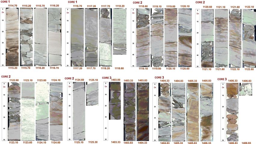
www.nature.com/scientificreports/
Figure 2. The main stratigraphic column of the Northeastern region of the Muglad Basin. It compares
sediments succession from Late Jurassic/Early Cretaceous—Quaternary with four sequences (I–IV) that
separated by unconformities.
and dominated by fluvial s ediments1. During that period, the sedimentation in the Mugald Basin was mainly
controlled by subsidence as a result of differential compaction of s ediments17.
The major stratigraphic units in the Mugald Basin can be subdivided into the Precambrian basement, the
upper Jurassic/Lower Cretaceous to Tertiary strata and the Tertiary to Quaternary sediments (Fig. 2). The base-
ment rocks in the basin consists of granitic and granodioritic gneisses. These rocks have been dated to be ca.
550 Ma1,3. The upper Jurassic/lower Cretaceous to Tertiary non-marine strata/sediments are deposited in fluvial,
alluvial fans, deltas, and lakes depositional environments. The non-marine and floodplain Abu Gabra formation
was deposited during the Albian to Aptian. It consists of shales, claystones and sandstones (Figs. 2, 3, Table 1).
The upper Albian to Cenomanian witnessed the deposition of the essentially thick sandstone sediments of the
Bentiu formation from braided and meandering streams1,3–5,7–9.
The Turonian to lower Campanian represents a coarsening-upward sediments of the Darfur Group. In the
Fula Sub-basin area (NE of the Mugald Basin), the Darfur Group is subdivided into Aradeiba, Zarga, Ghazal
and Baraka f ormations1,3–5,7–9. The Aradeiba formation overlies the Bentiu formation and consists of mudstone,
shale and thick sandstone beds (Fig. 2). The Zarga and Ghazal formations lie over the Aradeiba formation.
These formations represent topmost reservoir horizon in the entire Muglad Basin and comprises dominantly of
sandstone, siltstone, mudstone and shale lithologies deposited in fluvial and alluvial fan e nvironments1,3,16. The
Baraka formation comprises predominantly of thick sandstone interbedded with very thin beds of mudstone
(Fig. 2, Table 1). The thick massive sandstone of Amal formation overlies, the Baraka formation, and it is in turn
overlaid by the Kordofan Group, which consists mainly of lacustrine and fluvial claystones (Fig. 2, Table 1). This
rifting ended the deposition of the Zeraf formation during the Lower Oligocene to Recent. The dominantly
arenaceous Zeraf formation caps the stratigraphic column of the area and it was deposited in a braided fluvial
setting. (Figs. 2, 3, Table 1).
Methods of study. An estimated 14.29 m subsurface cores representing three cored intervals (core-
1, − 1114.70 to 1118.50 m, core-2, − 1118.50 to 1125.30 m and core-3, − 1403.30 to 1406.83 m) in the Keyi N-A
Scientific Reports | (2021) 11:743 | https://doi.org/10.1038/s41598-020-80831-y 3
Vol.:(0123456789)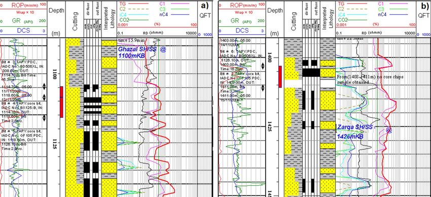
www.nature.com/scientificreports/
Age Formation Lithology and Environments
Recent-Middle Zeraf Predominantly iron-stained sands and silts
Miocene with minor claystones interbeds.
Adok
Kordofan
Braided streams/ alluvial fans.
Oligocene- Upper Tendi Predominantly claystone/ shale interbedded
Tertiary
Ecocene with sandstones.
Nayil
Fluvial/ floodplain and lacustrine.
Predominantly massive medium to coarse
Paleocene Amal sandstones sequences.
Braided streams/alluvial fans.
Predominantly sandstones with minor
Baraka shales and claystones interbeds.
Fluvial/ alluvial fans.
Predominantly sandstones with claystones
Darfur
Upper Senonian Ghazal and minor shales interbeds.
Turonian Fluvial/ alluvial fans.
Zarga Predominantly sandstones, shales with
Cretaceous
interbeds of siltstones and sandstones.
Floodplain/ lacustrine with fluvial/ deltaic
Aradeiba
channel sands.
Predominantly thick sandstones sequences.
Cenomanian Upper
Bentiu Braided / meandering streams.
Albian
Predominantly claystones and shales with
Albian- Aption Abu Gabra sandstone and fine siltstones.
Lacustrine/ deltaic.
Source rocks Reservoir rocks
Table 1. Stratigraphic units of the Muglad rift basin, SW Sudan, their lithology and depositional environment
(adapted from Schull 1988).
Figure 3. Depositional model showing the environmental effects during the filling of the Muglad Basin
(created from information in reference1).
well were used for this study (Fig. 5). The core-1 and 2 samples are from the Ghazal formation while core-3
samples are from the Zarga formation in the Muglad Basin. Apart from facies analysis, 14 core chips represent-
ing different lithofacies were subjected to further analysis as presented in Table 2. Lithological identification was
based on physical observations and logging the cores (Fig. 5) against the gamma ray log at a vertical scale of 1:30
(Fig. 6). Facies analysis was defined based on sedimentary structures and lithological signatures observed in the
cores. The thin section (TS) petrographic analysis was performed on the core chips (Table 2) using standard
laboratory procedures. Vacuum impregnation with blue dyed resin was carried out to ease recognition of poros-
ity. Carbonate minerals were identified by staining the samples with a mixture of Alizarin Red-S and potassium
ferric cyanide solutions, while staining with sodium cobalt nitrate solution was done to aid identification of
Scientific Reports | (2021) 11:743 | https://doi.org/10.1038/s41598-020-80831-y 4
Vol:.(1234567890)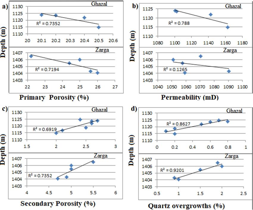
www.nature.com/scientificreports/
Figure 4. Location of the major basins across north north central Africa to the Benue Trough in Nigeria,
through Chad and Sudan in relation to the Central African Shear Zone (created from information in
reference16).
Figure 5. Conventional cores photos showing the studied core form Keyi N-A well.
Scientific Reports | (2021) 11:743 | https://doi.org/10.1038/s41598-020-80831-y 5
Vol.:(0123456789)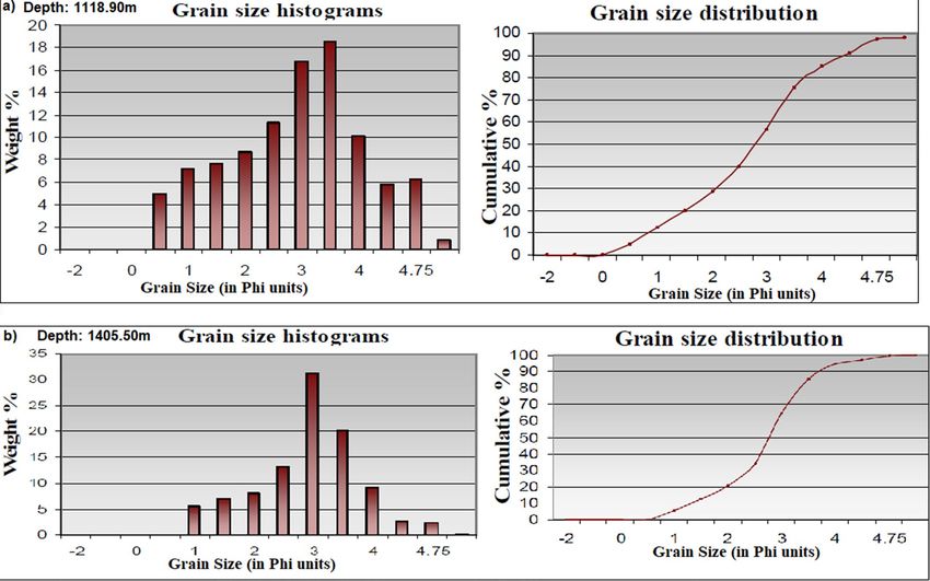
www.nature.com/scientificreports/
Analyses
XRD
Formation Core no Depth (m) Facies type TS SEM GS WR CF HM
1114.85 St 2 1 2 1 1 1
Core-1
1116.70 Sr 2 1 1 1 1 1
Ghazal 1118.90 Sr 1 1 1 1 1 1
Core-2 1121.90 Sp 2 1 2 1 1 –
1124.70 Sr 1 1 1 1 1 1
1404.10 Sm 2 1 1 1 1 1
Zarga Core-3 1405.50 St 2 1 2 1 1 1
1406.50 Sm 2 1 2 1 1 1
Total 14 8 12 8 8 7
Table 2. Details of analysis carried out on the studied core samples. All depth references are core depths. TS
thin section analysis, SEM scanning electron microscopy, GS grain-size analysis, XRD (WR) X-ray diffraction
analysis of the whole rock, XRD (CF) X-ray diffraction analysis of < 2 micron clay fraction, HM heavy mineral
analysis.
Figure 6. Well log response of Zarga (a) and Ghazal (b) formations sandstones.
alkali feldspar. Thin section slides were point counted and individual percentages of the minerals were computed
and presented on a data sheet. The classification of the rock type was based o n19,20.
Scanning electron microscopy (SEM) analysis was carried out on representative core samples to understand
the pore geometry, composition, and morphology of the main pore-filling authigenic minerals in the reservoir.
X-ray diffraction (XRD) analysis of the studied core intervals was based on previous workers’ s tandard21,22.**19,20.
Also, both whole rock (WR) and the < 2 microns clay fraction (CF) component were carried out on eight cored
chips (Table 1), while 12 representative samples (see Fig. 7) were used for grain size analysis. Heavy mineral sepa-
ration was done with bromoform (2.89 g/cm3) following established p rocedures23 and the resultant slides were
studied using polarizing microscope. The Jones and Roszelle method was adopted for permeability determina-
tion. Prior to this, the selected sample A (1118.90 m) was carefully chosen for the Flow-rate Dependency test to
formation brine24. For permeability check, the flow rate was used to evaluate the base specific permeability so as
to find out if there is any change in the permeability. Gas permeability was measured using calibrated steady state
permeameter with nitrogen gas as the flowing medium. The sample was placed in a Hassler type core holder and
the confining pressure used was 400 psi. A Klinkenberg correction was used for calibration of the permeability
data obtained from the permeameter device.
Results
Facies description. In this study eight (8) different lithofacies were identified (Table 3) and represented on
a pie chart as shown in Fig. 8. The facies types include.
Scientific Reports | (2021) 11:743 | https://doi.org/10.1038/s41598-020-80831-y 6
Vol:.(1234567890)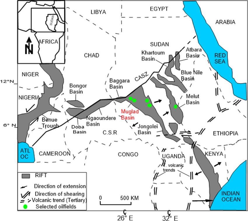
www.nature.com/scientificreports/
Figure 7. Grain size and sieve analyses histograms with cumulative weight percentage (curve in right) and
grain size distribution (curve in left) for the studied Zarga (a) and Ghazal (b) formations.
Ripple marked sandstone and siltstone (SR). The total thickness of this facies is 5.93 m as observed in core-1
and core-2 (Table 3, Fig. 5). It is light grey to grey colour sandstone with grain-size ranging from fine upper (FU)
to fine lower (FL) while the grain roundness varies from sub rounded to well round. The grains are dominantly
moderately sorted. Kaolinitic matrix is present and minor amount of carbonate cement has been identified.
However, despite having the same characteristics with the sandstone, the rippled laminated siltstone beds have
thickness of 0.60 m, which are lesser in thickness compare to the sandstone beds. Total porosity and permeability
is generally low for the analyzed samples of Sr-facies, while the other facies (St Sp and Sm) are relatively high.
This facies are similar to the “Sr” facies type in Miall’s classification. It is interpreted that the ripple marked sand-
stone beds were deposited on the top of fluvial bars while the rippled laminated siltstone beds were deposited
on the deltaic distal bar25.
Laminated to massive mudstone and shale (FCF/FM). This fine grained, kaolinitic rich facies is dark grey and
well sorted with a total thickness of about 3.08 m present in the three studied cores samples. It is partially lami-
nated and partially massive with some root casts which distinguish it from other facies such as Sr-facies. The
shale component displays some degree of fissility. The facies has been described as “Fcf and Fm” according to
Miall and interpreted as overbank (floodplain) deposits and deltaic distal b ars25.
Massive sandstone (SM). Massive sandstone facies type was observed in core-2 and core-3 with total thickness
of 1.85 m (Table 3, Fig. 5). The facies is typically grey with grain-size between fine upper (FU) to medium lower
(mL) having no evidence of lamination or ripple marks within a fining upward pattern. This well sorted grains
range from rounded to sub-angular and often associated with mica and carbonate cements. An oil show with
some organic matter has been observed as another feature of Sm-facies when compared to others (e.g. Fm and
Sr-facies). Observed porosity is reasonable high for the sample analyzed. This massive sandstone resembles the
“Sm” facies type in Miall’s classification and was formed by rapid sedimentation such as sheet-floods25.
Trough cross‑bedded sandstone (ST). This facies is present in core-1 and core-3 with a total thickness of 1.49 m
(Table 3, Fig. 5). It is grey and the grain size varies from fine upper to medium lower grained (fU—mL). The
grains are sub rounded to rounded with some sub-angular grains, and are well sorted. Few amounts of mica as
well as carbonate cements and some few iron oxides were noticed in form of red patches. This typical trough
cross-bedded facies shows relatively high total porosity and permeability in the studied cores. Thus, it could be
classified as “St” type according to Miall and interpreted as the deposits of migrating 3-D dunes in a braided
channel and deltaic mouth bars25.
Scientific Reports | (2021) 11:743 | https://doi.org/10.1038/s41598-020-80831-y 7
Vol.:(0123456789)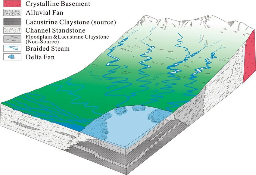
www.nature.com/scientificreports/
Interpretation of
Facies code Lithofacies Facies characteristics Facies description Total thickness (m) Percentage (%) depositional environment
Light grey fine upper (FU) Ripples (top fluvial bar or
Ripples marked sandstone Coarse grains with low
Sr to fine lower (FL) ripple 5.93 41.49 deltaic mouth bar and deltaic
and siltstone porosity and permeability
laminate facies distal bar)
Presence of cross stratifica-
tion, grey grain of fine upper
Trough cross-bedded to medium lower grained Coarse grains with high
St 1.49 10.42 Dunes (fluvial channel bar)
sandstone (fU—mL) with red patches porosity and permeability
of few iron oxides, few mica
and carbonate cements
Presence of bioturbations in
the grey coloured fine upper
Coarse grains with high
Bioturbated Laminated grained (fU) with moder- Deposits between deltaic dis-
Bs observed porosity and 0.16 1.11
sandstone ate porosity. It has some tal bar and deltaic mouth bar
permeability
scattered mud clasts and oil
shows
Dark grey plane parallel to
very low angle laminated Overbank or waning flood
Laminated mudstone and fine grains with low observed
FI fine grains associated with 1.21 8.46 deposits or delta distal bar
siltstone porosity and permeability
or without very small ripple deposits
marks
Grey Intraformational
Coarse grains with high
conglomeratic paticles with Fluvial bars and/or natural
Gm Mud conglomerate observed porosity and 0.12 0.83
mud casts & crudely bebded levee deposits
permeability
gravel
Grey facies of fine upper Linguoids, transverse bars,
Planar cross-bedded Coarse grains with high
Sp grained with Planar(tabular) 0.45 3.14 sand waves (fluvial channel
sandstone porosity and permeability
cross-bedding bars)
Structureless grey facies with
fine upper (FU) to medium
lower (mL) grains in a fining
Coarse grains with high Rapid sedimentation (high
Sm Massive sandstone upward pattern 1.85 12.94
porosity and permeability discharge event)
It has oil show with some
organic matter
Porosity is reasonable high
Fine grained dark grey
matrix with partial lamina-
Laminated to massive silt- fine grains with low observed Overbank (floodplain)
Fcf/Fm tion and partly massive 3.08 21.55
stone and shale porosity and permeability deposits
showing some root casts The
shale is fissile
Table 3. Facies parameters and inferred depositional environments of the cores from Keyi N-A well.
Figure 8. Pie chart of the different facies types in the studied core samples from Keyi N-A well.
Laminated mudstone and siltstone (FL). Dark grey fine laminated facies (mudstone and siltstone) has a thick-
ness of about 1.21 m found in core-2 and core-3 (Table 3, Fig. 5). A distinguishing feature of this facies is the
presence of plane parallel to very low angle laminated mudstones and siltstones associated with or without very
iall25. It can be inter-
small ripple marks. This fine-grained laminated facies is classified as “FI” according to M
preted as overbank or waning flood deposits or delta distal bar deposits.
Planar cross‑bedded sandstone (SP). This facies is grey and present in core-2 with a total thickness of 0.45 m
(Table 3, Fig. 5). The grains are fine upper grained (fU), sub-rounded, and well sorted. Some few carbonate and
iron oxide cements were observed. Kaolinite represents the dominant matrix (clay). Observed porosity and
permeability for the studied Sp-facies are also relatively higher (except the St-facies at 1114.85 m which compete
Scientific Reports | (2021) 11:743 | https://doi.org/10.1038/s41598-020-80831-y 8
Vol:.(1234567890)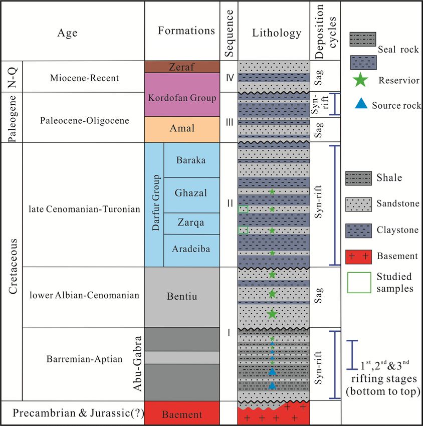
www.nature.com/scientificreports/
Depth = 1118.90 m Depth = 1510.55; Lithofacies = Sm
Sieve opening Sieve opening
Size grade (mic) Phi (Ǿ) Weight (g) Weight % Cumulative % Size grade (mic) Phi (Ǿ) Weight (g) Weight % Cumulative %
Pebble 4000 − 2.00 0.00 0.00 0.00 Pebble 4000 − 2.00 0.00 0.00 0.00
Granule 2000 − 1.00 0.00 0.00 0.00 Granule 2000 − 1.00 0.00 0.00 0.00
V.C Sand 1000 0.00 0.00 0.00 0.00 V.C Sand 1000 0.00 0.03 0.08 0.08
710 0.50 2.48 6.20 6.20 710 0.50 2.00 5.00 5.8
C. Sand C. Sand
500 1.00 2.61 6.53 12.73 500 1.00 2.14 5.35 10.43
355 1.50 2.73 6.83 19.55 355 1.50 2.34 5.85 16.28
M. Sand M. Sand
250 2.00 3.25 8.13 27.68 250 2.00 3.83 9.58 25.85
180 2.50 5.47 13.68 41.35 180 2.50 17.96 44.90 70.75
F. Sand F. Sand
125 3.00 9.81 24.53 65.88 125 3.00 5.77 14.43 85.18
90 3.50 8.11 20.28 86.15 90 3.50 2.25 5.63 90.80
V.F. Sand V.F. Sand
63 4.00 2.85 7.13 93.28 63 4.00 1.74 4.35 95.15
45 4.50 0.83 2.08 95.35 45 4.50 0.55 1.38 96.53
Silt Silt
32 4.75 0.88 2.20 97.55 32 4.75 0.47 1.18 97.70
Pan 10 < 37 6.50 0.68 1.70 99.25 Pan 10 < 37 6.50 0.41 1.03 98.73
Sieve loss 0.30 0.75 100.00 Sieve loss 0.51 1.28 100
Total weight after sieve 39.70 39.49
Table 4. Summary of grain size analysis.
Facies group No of samples Minimum diameter (mm) Maximum diameter (mm)
Rippled marked sandstone (Sr) 4 > 0.032 > 0.71
Trough cross-bedded (St) 3 > 0.032 >1
Massive sandstone (Sm) 3 > 0.032 >1
Planar cross-bedded (Sp) 2 > 0.032 > 0.5
Table 5. Statistical data of the analyzed samples grouped according to their facies types and association.
with it). Planar (tabular) cross-bedding is a typical structure to recognize the sandstone. This facies is “SP” type
according to Miall and interpreted to be linguoids, transverse bars or sand waves deposited in a fluvial channel25.
Bioturbated laminated sandstone (BS). Bioturbated laminated sandstone facies is grey and present in core-1
with a total thickness of 0.16 m (Table 3, Fig. 5). The grain size is fine upper grained (fU). Analyzed grains are sub
rounded to round and well sorted with observed moderate porosity. Aside reworking of by burrowing organism,
a basic feature of this facies is the presence of some scattered mud clasts and oil shows in the studied samples.
Thus, the facies is classified as “Bs” after Miall and interpreted as between a deltaic distal bar and deltaic mouth
bar25.
Mud conglomerate (GM). This facies is grey intraformational conglomerate and present only in core-3 with
thickness of 0.12 m (Table 3, Fig. 5). A lot of mud casts were observed in this crudely bebded gravel. This facies
could be classified as “Gm” type according to Miall and could be interpreted as the deposits of mouth b ar25.
Textural parameters. The grain-size analysis revealed that all the studied samples are dominantly of sand-
size (< 0.09 mm to > 1.00 mm) (e.g. Tables 4, 5, Fig. 7), with silt and clay components (< 0.09 mm) occurring in
minor quantities. Generally, the < 250 μm (0.25 mm) and > 90 μm (0.09 mm) components dominate all studied
samples. An estimated 83.33% of the analyzed samples are well sorted to moderately well sorted, while the rest
are considerably poorly sorted (Table 6).
Petrography. The source rock provenance determines the sandstone composition. Petrography, the sand-
stone contains quartz, feldspar, micas (mainly biotite and muscovite). Also present are rock fragment, opaque
and heavy minerals as well as authigenic components such as iron oxides, quartz overgrowth, siderite cement,
and authigenic clays (Table 6). These minerals and the authigenic components are highlighted below.
Quartz. It is the most common mineral in the sandstones appearing as dull grains having weak birefringence
and low refractive index that is only slightly higher than that of the mounting medium26,27. Monocrystalline
quartz (Qm) and polycrystalline quartz (Qp) were seen. Monocrystalline quartz (20.3–26.2%) is more in abun-
dance than the polycrystalline quartz (2.6% to 13.8%) as shown in Table 6. Fractured quartz grains are also com-
Scientific Reports | (2021) 11:743 | https://doi.org/10.1038/s41598-020-80831-y 9
Vol.:(0123456789)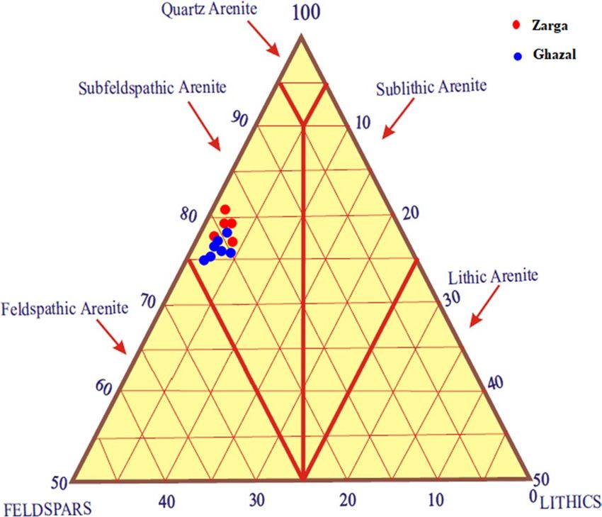
Vol:.(1234567890)
Scientific Reports |
Textural data Detrital mineralogy Authigenic minerals Porosity
Qtz
(2021) 11:743 |
Poly Lithic Total Heavy Clay Calcite Siderite over Pyrite
Depth Grain Grain Grain AV. pore Pore crystalline Monocrystalline Total fragment. K-feldspar Plagioclase feldspar Micas minerals matrix cement cement growth cement Iron oxide Total Primary Secondary Total Permeability
(m) Facies sorting contacts roundness connectivity types Rock name Qtz. % Qtz. % Qtz % % % % % % % % % % % % cement % cements % % porosity% (mD)
Sub-
1114.85 St WS CPLF SR-SA Good feldspathic 7.4 26.1 33.5 1.3 6.0 2.2 8.2 3.0 1.5 11.0 2.1 13.6 0.2 1.1 2.0 19.0 20.5 2.0 22.5 1196.71
www.nature.com/scientificreports/
arenite
Sub-
1116.70 Sr MS FPC SA-A Fair-good feldspathic 2.6 21.5 26.1 2.0 4.2 2.4 6.6 7.6 0.6 28.0 2.0 5.2 0.1 2.2 2.4 10.9 17.1 2.1 19.2 161.87
arenite
Sub-
1118.90 Sr WS CPLF SR-SA Good feldspathic 3.4 20.3 25.7 0.5 4.7 3.0 7.7 5.2 1.3 27.0 1.8 5.9 0.2 2.8 5.5 15.2 15.9 2.5 18.4 9.65
arenite
Feldspathic
1121.90 Sp MS-WS PL SA-SR V.Good 5.1 25.2 33.3 2.7 6.0 2.3 8.3 3.5 0.9 13.9 2.0 3.6 0.5 1.7 7.3 15.1 20.4 2.9 23.3 1192.7
arenite
Feldspathic
1123.50 Sp MS-WS PL SA-SR V.Good 9.4 23.7 34.1 1.2 7.1 2.0 10.1 5.4 0.6 13.2 2.6 6.2 0.6 2.7 0.9 17.0 20.4 3.0 23.4 1102.45
arenite
Feldspathic
1124.00 St WS CPLF SR-SA Good PBP 7.8 23.2 31.0 1.2 5.3 2.2 7.5 4.7 0.8 12.5 2.4 11.0 0.8 1.1 2.7 17.8 20.3 3.9 24.5 1100.5
arenite
SWP
SBP Feldspathic
1124.70 Sr PS PL SA-SR Good 5.0 19.3 26.3 1.0 5.0 2.2 7.2 2.2 2.0 27.0 2.8 4.0 0.7 1.6 7.3 16.4 15.5 2.4 17.9 48.5
arenite
Feldspathic
1404.10 Sm MS-WS PL SA-SR V.Good 13.8 25.0 38.8 1.1 6.1 3.2 9.3 1.4 1.4 9.0 2.0 2.4 1.0 0.5 2.4 8.3 26.0 4.7 30.7 1059.2
arenite
Sub-
1404.30 Sm MS-WS PLS SA-SR Excellent feldspathic 13 25.0 38.0 0.8 6.2 2.0 8.2 2.3 0.9 9.2 1.6 4.1 0.9 1.1 2.4 10.1 25.6 4.9 30.5 1090.45
arenite
Sub-
1405.50 St MS-WS PCLS SR-R Good feldspathic 11.1 22.1 35.2 2.0 5.2 4.4 9.6 3.0 1.7 8.4 1.7 4.1 1.5 1.5 1.9 10.2 24.4 5.0 29.4 1057.53
arenite
https://doi.org/10.1038/s41598-020-80831-y
Sub-
1406.00 Sm MS-WS FPL SR-SA V.good feldspathic 12.0 22.1 34.1 0.7 7.2 2.8 9.0 3.2 2.0 8.8 1.1 4.5 2.0 0.6 4.0 12.2 25.0 5.0 30.0 1051.09
arenite
Feldspathic
1406.50 Sm MS-WS FPL SR-SA V.good 11.2 26.2 36.4 1.3 7.3 3.0 10.3 2.9 1.0 8.9 1.4 5.4 1.9 0.6 2.2 11.5 22.2 5.5 27.7 1070.45
arenite
Table 6. Petrographic data for the studied samples. WS well sorted, MS moderately sorted, PS poorly sorted, C concavo-convex, P point, L long, F floating grains, S sutured, PBP primary
interparticle, SWP secondary intraparticle, SBP secondary interparticle.
10www.nature.com/scientificreports/
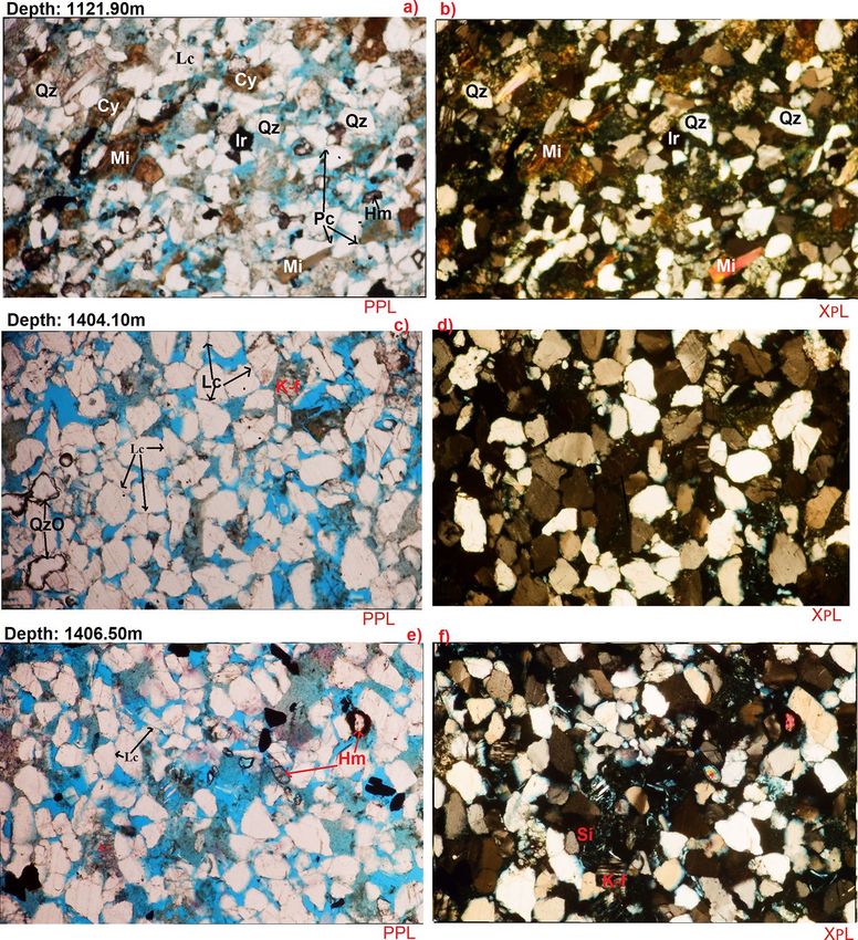
Figure 9. (a–f) Fine to grained, well sorted, sub rounded to sub angular, patchy cemented, and moderately
compacted with point, concavo-convex and long grain contacts Sub Feldspathic Arenite, common
monocrystalline and polycrystalline quartz (a–f). Some quantities of mica (a,b) which arranged along the
bedding plane due to the hydraulic fraction of the mica flakes as well as very few heavy minerals (a,e).
Considerable amount of detrital clays occupying some pore spaces (a,b). Some quantities of iron oxides cement
occur as pore filling (a,b), minor amount of quartz overgrowths (c) as well as with some amount of siderite (f).
Qz quartz, QzO quartz overgrowth, Lc long grain contact, Pc point contact, Cy clay, Mi mica, Ir iron oxide, Hm
heavy mineral, K-f K-feldspars, Si siderite.
mon. The quartz grains are mainly sub rounded to sub angular and are well sorted to moderately sorted (Table 6,
Fig. 9a–f). Most of the quartz crystals exhibit undulose extinction with some of the polycrystalline quartz grains
being granular and having sutured boundaries. The quartz grains coalesce minerals such as rutile, zircon, iron
oxides and tourmaline (Fig. 9).
Feldspars. K-feldspars (Fk) such as orthoclase (Or), microcline (Mi) and perthite (Pe) are the dominant feld-
spars observed with relative abundances of 4.2% to 7.3%, while Plagioclase feldspar range between 2.2 and 4.4%
(Table 6). The K-feldspar shows different degrees of alteration and dissolution ranging from relatively fresh,
unaltered grains to partly to almost completely dissolve (Fig. 9c–f). Predomination of K-feldspar over plagio-
clase feldspar could have resulted from the preferential breakdown of the latter as the former characteristically
have more stable chemical s tability28. In addition, K-feldspar is much more common in continental basement
rocks (acid gneisses)28, which are probably the provenance of many sandstones in the study area.
Micas. Biotite (Bi) and muscovite (Mu) were identified by their platy cleavage and parallel extinction. Biotite
has a brown to green pleochroism while muscovite appears dull under plane-polarized light, but with bright
second-order color under crossed polarized light26. The concentration of the mica varies in the examined sam-
ples, the highest was at 1116.7 m having 7.6% (Table 6, Fig. 9a,b). These micas generally occur as large detrital
Scientific Reports | (2021) 11:743 | https://doi.org/10.1038/s41598-020-80831-y 11
Vol.:(0123456789)www.nature.com/scientificreports/
Figure 10. (a) High cemented with relative closed grain packing and low degree of intergranular porosity. (b) Few amounts
of stacked pseudo hexagonal plates of kaolinite partially filling a pore ((b) E–F 5–6). Considerable amount of pyrite, which
observed within the pores ((b) C–F 7–8; E–F 11–12). Few quantities of iron oxides occur between the detrital grains ((b) B–C
6; F7). Minor amount of carbonate ((b) F–G 8–9). (c) Moderately cemented with relatively open grain packing and medium
degree of primary intergranular porosity ((c) D–E 2–5 & D–G 6–12). (d) Common corroded detrital plates of kaolinite
partially filling some pores and partially cover some detrital grains ((d) C–D 2–4 & E–H 11–13). Some authigenic kaolinite
appears as pseudohexogonal plates or books arranged faceto- face into an elongated stacked form called verm (d): D–G 7–10
& A–B 11–12) Some rose-like shape of chlorite ((d) A–D 3–7).
Scientific Reports | (2021) 11:743 | https://doi.org/10.1038/s41598-020-80831-y 12
Vol:.(1234567890)www.nature.com/scientificreports/
Clay minerals %
Core no Sample depth (m) Kaolinite Smectite Illite Chlorite Illite/chlorite
1114.85 41.5 0.14 0.93 19.0 0.07
1
1116.70 59.9 2.04 3.79 34.1 0.15
1118.90 75.2 0.83 1.34 22.5 0.10
2 1121.90 86.4 0.09 0.41 13.1 0.09
1124.70 49.1 0.10 0.44 50.3 0.10
1404.10 85.0 0.06 0.25 14.6 0.06
3 1405.50 79.8 0.14 0.93 19.0 0.07
1406.50 82.5 0.05 2.43 14.9 0.10
Table 7. Percentages of the clay minerals in the analyzed samples.
Figure 11. Representative XRD graphical charts showing the degree of crystallinity of the clay minerals present
in the studied core samples.
flakes concentrated along partings, laminae, and bedding planes. The distribution is primarily a function of sort-
ing and is determined by the hydraulic behavior of the mica flakes28. Also, few micas shows curvilinear structure
indicating moderate compaction.
Opaques. These accessory detrital components occur in minor amounts (trace quantities). Opaque are mainly
hematite and pyrite. Opaque grains are very fine to medium grained and show moderate abrasion.
Heavy minerals. Microscopic investigation of 7 samples from Zarga and Ghazal formations in the studied
intervals, a few major heavy minerals were identified. They occur in minor amount in all the studied samples.
Heavy Mineral concentration ranges between 0.6 and 2.0%. Moreover, they have been observed as free grains
and/or enclosed inside the quartz grains (e.g. Fig. 9e).
Detrital clays. Detrital clays have been recorded in all the studied samples, where their relative abundances
vary between 8.4 and 23.0% that recorded at depths of 1405.50 m and 1124.70 m, respectively. However, thin
section analysis suggests that the vast majority of the interstitial clays are authigenic in origin particularly the
kaolinite.
Carbonates. Siderite (Sid) and calcite (Ca) were noticed as patchy cements in all the observed samples (Table 6).
Calcite and siderite abundance are up to 2.8% at 1124.70 m and 13.6% at 1114.85 m. Both minerals can be identi-
fied by their perfect rhombohedral cleavage and a pearl grey or white high order interference color. Calcite is
dull, but often cloudy, usually anhedral whereas, siderite resembles calcite but may often be distinguished by
brown stains around the borders of the grains and along cleavage zone26.
Scientific Reports | (2021) 11:743 | https://doi.org/10.1038/s41598-020-80831-y 13
Vol.:(0123456789)www.nature.com/scientificreports/
Figure 12. QFL Ternary Diagram for Sandstone Classification of the Zarga and Ghazal Formations sandstones
(created from information in reference33). QFL Quartz–Feldspars–Lithics.
Quartz overgrowths. Well developed syntaxial quartz overgrowths are recorded in almost all the analyzed sam-
ples ranging between minor amount and 2% (Table 6, Fig. 9c). Thin section observations revealed the presence
of well-developed euhedral, quartz overgrowths.
Iron oxides cement. Iron oxides are widely spread in the examined samples and they were recorded as a cement-
ing material. However, the higher percentage which is 7.3% was recorded at depths of 1121.90 m and 1124.70 m
(Table 6).
Pyrite. Authigenic pyrite as cementing and replace agent has been noticed in all the studied samples (Table 6).
Through the core description, pyrite nodules were recorded as cement filling within the pores. SEM analysis
shows presences of patchy aggregates of sub cubic to cubic pyrite as micro crystals.
Scanning electron microscopy (SEM). The SEM analysis involved a detailed investigation and description for
the sample material with a special focus on the pore geometry, composition as well as on the morphology of the
main pore-filling authigenic minerals. Kaolinite, pyrite, iron oxides and carbonate minerals (Fig. 10) are identi-
fied in the samples. The characteristics of the studied samples are further illustrated by two photomicrographs
for each examined sample (e.g. Figure 10) in order to clarify the diagenetic effects of the clay minerals on the
reservoir quality.
Clay minerals. Eight clay rich samples from the studied intervals have been analyzed and five clay mineral
species were identified from the size fraction less than 2 microns. The five clay minerals species are: Kaolinite,
Chlorite, illite, smectite and smectite/illite (Table 7).
Kaolinite. This is common in all the examined sandstones in varying concentration between 41.5 and 86.4%
(Table 7). Kaolinite forms mostly in surficial environment through pedogenetic processes29. It may also occur in
water environment from the alteration of K-feldspar in acid organic rich w aters28. Moreover, hydrothermal alter-
ation of aluminosilicates, especially of feldspars may also form k aolinite19,20. According to Keller and Weaver,
formation of detrital kaolin minerals required presence of H+ ions and efficient removal of metal c ations30,31.
These conditions are favored by strong leaching in the source area, which implies abundant rainfall, perme-
able rocks and favorable topography, and hence, evacuation of the Ca, Mg, Na and K ions. Climatic conditions
favorable for the formation of kaolin mineral are essentially tropical and subtropical.
The sharp peaks of the kaolinite in most of the XRD charts (e.g. Fig. 11) implies great part of the kaolinite is
monocrystalline31, have been authigenically formed. However, other part of the kaolinite in the studied intervals
is detrital formed by hydrolytic processes and have been confirmed by the relatively flattened kaolinite peaks
in the XRD (Fig. 11).
Chlorite. Chlorite concentration ranges between 13.1 and 56.5% (Table 7). Petrographic investigation shows
chloritization (Fig. 10d), where chlorite clay mineral fills up pore spaces between grains. Chlorites are consid-
ered either as a 2:1 or as a 2:1:1-layer group with a hydroxide interlayer. Their typical structure shows a regular
alternation of negatively charged trioctahedral micaceous layers and positively charged octahedral film. Part of
the chlorite within the examined intervals is detrital and derived from biotite-rich metamorphic source rocks
Scientific Reports | (2021) 11:743 | https://doi.org/10.1038/s41598-020-80831-y 14
Vol:.(1234567890)www.nature.com/scientificreports/
Figure 13. Classification of sandstones in the study area (created from information in r eference33).
Figure 14. Tectonic setting of the studied sandstone (created from information in r eference37).
during the intermittent hot dry periods. However, other part is authigenic formed by the alteration of the biotite
as revealed by the petrographic analysis of sample depth 1121.90 m (Fig. 9a).
Smectite. Clay mineral abundance is between 0.05 and 2% (Table 7). According to Weaver, the climatic and
topographic determinants essential for the formation of smectite are basically the opposite to those which favors
the formation of kaolinite31. Smectite is in most cases formed in low relief areas where poor drainage prevents
the silica and the alkaline earth ions such as K+, Na+, Ca+2 and M
g+2 from being leached out. Moreover, smec-
tite is formed from the weathering of basic and ultra-basic rocks or their metamorphic equivalents in areas of
low rainfall, low water flux and low temperature. The smectite peaks are not sharp as in kaolinites, as such this
implies greater part of the smectite is polycrystalline reflecting detrital occurrence (Fig. 11). This detrital smec-
tite was formed during the intermittent hot dry season prevailing at the source area. However, the prevailing low
content of the smectite in these cored intervals could be due to the late transformation of the smectite to illite,
as well as to chlorite.
Discussion
Sedimentological and petrographical characteristics. The core samples from the Keyi N-A Well
comprises essentially of continental clastics. The succession composes dominantly of sandstone facies (Sr, Sm,
St, Sp & Bs facies). The studied core-3 and core-1 intervals display coarsening upward sequences, whereas core-2
displays a dominantly fining upward sequence (Fig. 5). The fining upward succession starts with a fine-grained
facies (ripple laminated sandstone beds), and then passes dominantly to massive mudstone and shale beds. How-
ever, in few cases the fining upward sequences start with fine grained massive, planar, or trough cross-bedded
Scientific Reports | (2021) 11:743 | https://doi.org/10.1038/s41598-020-80831-y 15
Vol.:(0123456789)www.nature.com/scientificreports/
sandstone facies, and typically end with mudstone beds (Fig. 5). The thickness of the fining upward sequences
range between 0.20 and 1.16 m (Fig. 5 core-2). The coarsening upward sequences start mainly with massive to
laminated mudstone beds, and end with fine to medium grain-size ripple marked or trough cross-bedded sand-
stone facies (Fig. 5). The thickness of the coarsening upward successions varies between 0.35 and 1.52 m (Fig. 5
core-1 and 3).
The coarsening upward sedimentary sequences in Zarga formation typically start with a massive mudstone
or laminated mudstone interval, and end with massive medium sandstone or trough cross-bedded fine-grained
sandstone (Fig. 5). The sedimentary succession in core-1 and 2 of the Ghazal formation suggests deposition in
a fluvial system that was later predominantly succeeded by deltaic depositional environment, whereas the sedi-
mentary signatures in the Zarga formation (core-3) indicate a dominant deltaic depositional setting.
Sedimentological characteristics of the studied cores led to the identification of eight facies assemblages: the
ripple mark sandstone and siltstone Sr, massive mudstone and shale Fm, massive sandstone Sm, trough cross-
bedded sandstone St, laminated siltstone and mudstone FI, planar stratified sandstone SP, bioturbated sandstone
Bs, and mud conglomerates Gm (Table 3).
The analyzed samples are somewhat rich in quartz and feldspars, with less lithics or rock fragments. Using the
Dott32 and Pettijohn et al.33 classification schemes, the studied sandstone facies plotted under the sub-feldspathic
arenite (Fig. 12) and subarkose fields (Fig. 13), respectively. The preponderance of detrital and authigenic compo-
nents in the sandstone are in the order of (from abundant to least abundant) mono-crystalline quartz polycrystal-
line quartz, feldspar, mica, detrital clay, authigenic clay, and carbonaceous remains. Other accessory materials
like lithic fragment, iron oxide and heavy mineral occur in trace amounts within the analyzed samples (Table 3).
Kaolinite is present as authigenic constituent, while varying quantity of carbonates occurs with insignificant
amount of quartz overgrowths in majority of the analyzed cores (Table 6, Fig. 10). The Sandstone grains are sub-
rounded to sub-angular, fairly compacted, and exhibit concavo-convex, long and float grain-to-grain contacts
(Fig. 9). On the other hand, sutured grains, which portray much compactional influence were noticed in minor
samples. Pore types in the analyzed samples are dominantly primary and secondary interparticle f orms8. The
secondary intraparticle porosity was derived after partial dissolution of the detrital feldspars. The pores are
often filled with kaolinite, carbonates, and quartz; thereby reducing the porosity (Fig. 10). In the Zarga forma-
tion (Core-1 and 2) pore point counts range from 17.9 to 24.5% (e.g. facies Sr & Sp,), whereas pore counts in the
Ghazal formation sample (core-3) vary between 27.7 and 30.7%, with average pore sizes that are highly variable
ranging from 25 to 345 microns (e.g. facies Sm). The pore interconnectivity ranges from fair to good in the
Ghazal formation, while the Zarga formation has pore interconnectivity that is good to very good. Thus, better
reservoir quality is implied for the Ghazal formation reservoir sandstones in contrast to the Zarga formation
reservoirs. Modal analyses of the sandstone depict its origin from continental provenance, transitional within
stable interior of a craton and basement uplift that is a basement area of generally elevated along rifts (Fig. 14).
Clay mineral analysis highlights kaolinite, chlorite, illite, smectite and smectite/ illite as the main clay mineral
constituents of the studied samples (Table 5, Fig. 10). XRD charts shows actuate peak kaolinitic monocrystal-
line signifying it was authigenically formed, although few of the kaolinites are detrital. Chlorite content is partly
authigenic and partly detrital in origin. Lower horizons have higher amounts of kaolinite implying leaching and
chemical weathering effects in humid warm climatic condition, whereas the upper horizon contains high chlorite
and smectites due to hot dry condition.
Grain-size distribution analysis of the sandstone samples indicates that all examined samples contains sand-
size fractions (> 0.063–0.5 mm), while silt and clay size (< 0.063 mm) particles occur in lesser amount across
all facies except for the Sr facies, which shows significant clay content up to 28%. Exceptionally, three samples
contain components with grain-sizes greater than 1.00 mm. Moreover, components of grain-sizes range between
more than 250 μm and greater than 63 μm (> 0.063 to > 0.250 mm) exemplifying the dominant constituents in
all the samples. Similarly, granulometric analysis shows that four samples are well-sorted, one sample is poorly
sorted while the rest samples are moderately to well-sorted.
Grain textural features. Grain textural features provide information on the geometry of individual grains
including grain sizes, grain shapes, sorting, and packing. These geometrical attributes have direct effect on
primary porosity and permeability, even though porosity is independent of grain sizes, whereas permeability
decreases with decreasing grain sizes8. Chen et al. pointed out that coarse grain sizes give rise to higher poros-
ity values than the fine grained particles34. Most of the examined Zarga formation samples are characterize by
coarse grain with occasional medium grain sizes. The total clay content in this formation ranges from 8.4 to
9.2% whereas Ghazal formation clay content is from 11.0 to 28.0% (Table 6). Facies Sr has finer grain sizes than
the other facies having low clay content. Porosity increases with degree of roundedness, and rounded grains are
more porous than angular particles. Greater porosity values are recorded for highly anisometric p articles8,26. The
grain roundness in all the studied samples is less variable (Fig. 9a–f). Most of the samples are sub-rounded to
sub-angular in shape, while only few samples show varying degree of roundness (Table 6). Isometric particles are
observed in the samples dominated by very fine grain particles and high total clay content (facies Sr). Similarly,
increasing sorting result in higher porosity and permeability. In poorly sorted sediments, clayey and very fine
grain sizes could be found between larger grains thereby decreasing the porosity and p ermeability8,35,36. The sort-
ing pattern of the sandstones is between moderately to well-sorted with few samples being poorly sorted. Poros-
ity and permeability decrease further by deformation and packing of the sediment grains. Loosely cemented
particles have high porosity and less grain-to-grain contacts8,36. Majority of the studied sandstones are less com-
pacted as shown in Fig. 5a–f. Also, grain-to-grain contact are displayed significantly well in the less clay rich
samples.
Scientific Reports | (2021) 11:743 | https://doi.org/10.1038/s41598-020-80831-y 16
Vol:.(1234567890)www.nature.com/scientificreports/
Provenance of the sediment. The percentage of the different sandstone grains are plotted on a triangular
diagram for modal analysis, which depicts their provenances (Fig. 14). The modified QmFL triangular plot of
Dickinson et al., shows the monocrystalline quartz grain, the feldspars and the lithic remains which emphasis
maturity of the sediment37. This diagram plays a role in classifying sandstones from different tectonic settings
(Fig. 14). The triangular plot illustrates that the sandstones originate through transitional provenance around
the continental part within the stable interior of the craton and the basement uplift along rifts (Fig. 14). This
enables the detrital constituents to be reclaimed after being moved for quite a long distance and accumulated
in an extensional and pull-apart basin. Paucity of siderites, calcites and iron oxides besides their co-existence
suggest that the lake system was hydrologically open and maximum lake level was imposed by an outlet having
relatively stable water level seaside.
Diagenetic processes. Petrographic analyses of samples from the Zarga and Ghazal formations indicated
that diagenetic signatures affected their syndepositional porosity and permeability thereby altering reservoir
quality. Identified factors that increase porosity and permeability are dissolution of feldspar and mica, partial
dissolution of carbonate (calcite) cement and clay. Contrastingly, the porosity and permeability reducing pro-
cesses are the presence of detrital clays, kaolinization, iron oxide precipitation, carbonate cementation, compac-
tion, quartz overgrowths and pyrite cementation8.
The richness of detrital clay minerals, which reduces the porosity and permeability within the Zarga and
Ghazal formations varies from 8.4 to 28.0% (Table 6). Based on XRD analysis, the detrital clay minerals are
mainly kaolinite and chlorite (Table 7). They were further analyzed using SEM technique (Fig. 10a–d). Figure 10
shows few amounts of stacked pseudo hexagonal plates of kaolinite partially filling a pore (b: E–F 5–6), consid-
erable amount of pyrite, occurring within the pores (b: C–F 7–8; E–F 11–12: d: C–D 2–4 & E–H 11–13). Some
authigenic kaolinites appear as pseudo-hexogonal plates arranged into an extended stacked form called verm
(d): D–G 7–10 & A–B 11–12). Some rose-like shape of chlorite (d: A–D 3–7) was also detected. The kaolinite and
chlorite can disaggregate into pore spaces and throats, thereby causing a decrease in porosity and permeability.
The reservoir quality could be further enhanced by the dewatering process38. This assertion is supported by the
absence or low smectite and illite minerals in all the studied samples yielding high secondary porosity (2.5% to
5.5%) with an average of 3.6%. Also, considerable amount of pyrite were observed within the pores (Fig. 10b:
C–F 7–8; E–F 11–12), few quantities of iron oxides occurring between the detrital grains (Fig. 10b: B–C 6; F7)
and minor amount of carbonate (Fig. 10b: F–G 8–9).
Quartz, pyrite, and siderites are the major cementing materials observed in Zarga and Ghazal sandstones.
Quartz overgrowth is the major detracting factor reducing reservoir q uality8,39,40. Although some mineral cements
are in minor quantity, quartz overgrowth results in the reduction in pore spaces, which in turn causes a decrease
in porosity and permeability8. Quartz overgrowth do not exceed 2.0%, occurring as nucleated cells around some
of the quartz grains and grow into macro pores (e.g. Figs. 9c, 10c). It often results in reduction of macro porosity.
Pyrite cement is in the range of 0.5% to 2.8% for most of the samples. Porosity and permeability are relatively
low in the samples with higher pyrite concentration compared to ones with low p yrites8. Iron oxides also act as
minor cementing agent filling pore spaces in the studied samples (Fig. 9a). Siderite, which is also considered as
a cementing material occurs as pore-filling crystal between the grains (Fig. 9f).
Compaction is the degree to which sediments burial leads to porosity and permeability decrease with increas-
ing depth due to effects of pressure from loading and c ementation8,40. Most of the examined samples are poorly
to moderately compacted. Sutured grain contact that usually reflects a higher degree of compaction was not
observed on the coarse grain samples, but long grained concavo-convex contacts were noticed in some samples
(e.g. Fig. 9c). Yet, the intergranular pore spaces left after compaction process are smaller in the fine-grained sedi-
ments (Fig. 9a). This affirms that compaction influences porosity and permeability. This is concordant with the
findings above implying that sedimentology and grain textural features have direct effect on reservoir quality.
Conversely, the porosity and permeability of reservoirs can be further increased by dissolution of feldspars,
micas, and carbonate c ements8,41. Secondary porosities are primarily related to dissolution of feldspar minerals
and calcite c ement41,42. Secondary porosity is the most prevalent diagenetic process, depending on leaching of
feldspar grains and dissolution of calcite c ement8,41. This present study shows that K-feldspar has little degree of
alteration and dissolution, ranging from partially dissolved (Fig. 9e) to relatively fresh unaltered grains (Fig. 9f).
Alteration and dissolution are the two processes yielding secondary porosity in Zarga and Ghazal formations.
These lead to kaolinization and quartz overgrowth in subsequent stages8. In the examined samples, kaolinite and
quartz cement play less significant role on the reservoir quality as most of the studied samples have high porosity
and permeability (Table 6), except high clayey samples (facies Sr). Chlorite which usually improves grain com-
paction resistance hinders quartz cementation, preserves the porosity and permeability as noticed in the studied
samples34,41. Similarly, dissolution of mica resulted in secondary porosity. Minor amount of micas was observed
in all the investigated samples (Table 6), which ascertains good quality reservoir. On the other hand, sediments
having high mica content shows pressure solution compaction that damages intergranular porosity (Fig. 9a,b).
Burial depth. The examined cores cover Zarga and Ghazal formations of the Keyi oilfield in the Northeast-
ern Muglad Basin. Tables 2, 6 and 7 show the depth intervals of the core samples. The studied Ghazal formation
(1114.85 m to 1124.70 m) samples are at relatively shallower burial depths compare to the Zarga formation
samples (up to 1406.50 m). Zarga formation (Sm Sr, St & Sp facies) samples have slightly higher porosity and
permeability than that of Ghazal formation (Table 6). The plots of primary porosity and permeability values
against burial depth (Fig. 15a,b) fall within normal trend, implying that porosity and permeability decreases
with increasing burial depth. On the other hand, secondary porosity of the analyzed facies (Sm Sr, St & Sp) dis-
plays a positive trend with the increasing burial depth (Fig. 15c). This is because as the burial depth increases,
Scientific Reports | (2021) 11:743 | https://doi.org/10.1038/s41598-020-80831-y 17
Vol.:(0123456789)You can also read