Bandera Central Appraisal District - Reappraisal Plan 2021-2022 Approved by the Bandera BOD
←
→
Page content transcription
If your browser does not render page correctly, please read the page content below
Bandera Central Appraisal District

         Reappraisal Plan
            2021-2022
          Approved by the Bandera BOD
                August 21, 2020
TABLE OF CONTENTS
INTRODUCTION ______________________________________________________________ 5
Scope of Responsibility
Tax Code Requirement
PRELIMINARY ANALYSIS _____________________________________________________ 7
Market Study
Land Value
Area Analysis
Neighborhood Analysis
Highest and Best Use Analysis
Market Analysis
REAPPRAISAL DECISION_______________________________________________________ 8
APPRAISAL RESOURCES AND RESPONSIBILITIES ________________________________ 8
Personnel Resources
Information Technology Resources
Financial Resources
Data Resources
PLANNING AND ORGANIZATION ______________________________________________ 10
Areas of Focused Reappraisal
Appraisal Frequency and Methodology
Residential Property
Residential, Rural and Commercial Land
Business Personal Property
Commercial Property
Industrial, Utility and Minerals
Target Dates
MASS APPRAISAL SYSTEM ___________________________________________________ 13
Real Property Valuation
Personal Property Valuation
Notice Process
Hearing Process
BCAD 2021-2022 Reappraisal Plan Page 2 of 30DATA COLLECTION PROCEDURES ____________________________________________ 14
Residential & Commercial Property
Residential, Rural and Commercial Land
Business Personal Property
Industrial, Utility and Minerals
PRODUCTION OF VALUES ____________________________________________________ 15
Sources of Data
Cost Schedules
Income Models
Sales Comparison Approach
Final Valuation Schedules
Statistical and Capitalization Analysis
INDIVIDUAL VALUE REVIEW PROCEDURES ___________________________________ 18
Field Review
Office Review
Performance Tests
Sales Ratio Studies
Comparative Appraisal Analysis
PERFORMANCE TEST ________________________________________________________ 19
Statistical Analysis
Review by Inspecting Appraiser
DATA MAINTENANCE _______________________________________________________ 20
New Construction/Demolition
Remodeling
Re-Inspection of Changing Market Areas
Re-Inspection of the Universe of Properties
Field or Office Verification of Sales Data and Property Characteristics
DISTRICT MARKET AREAS ___________________________________________________ 21
Residential Property
Residential, Rural and Commercial Land
Business Personal Property
Industrial, Utility and Minerals
BCAD 2021-2022 Reappraisal Plan Page 3 of 30VALUATION BY PROPERTY TYPE ______________________________________________ 23
Residential Real Improved and Vacant (Cat A, B, C, D, E)
Cost Schedules
Sales Information
Statistical Analysis
Market and Cost Reconciliation and Valuation
Commercial and Industrial Real Property (Cat F)
VALUATION BY PROPERTY TYPE (NON-RESIDENTIAL, NON-COMMERCIAL) ______ 25
Mineral Properties (Cat G) and Utilities (Cat J)
Business Personal Property (Cat L)
NAICS Code Analysis
Sources of Data
Vehicles
Leased and Multi-Location Assets
Cost Schedules
Statistical Analysis
Depreciation Schedules and Trending Factors
Real Property Inventory (Cat O)
Special Inventory (Cat S)
APPRAISAL CALENDARS ____________________________________________________ 27
LIMITING CONDITIONS AND CERTIFICATION STATEMENT _____________________ 29
RESOLUTION APPROVING REAPPRAISAL PLAN ________________________________ 30
Addendum:
Hugh Landrum & Associates, Inc. 2021-2022 Mass Appraisal Methodology Manual & Reappraisal Plan
BCAD 2021-2022 Reappraisal Plan Page 4 of 30INTRODUCTION
Scope of Responsibility
The Bandera Central Appraisal District (Bandera CAD) has prepared and published this reappraisal plan as
required under Section 6.05 (i) and Section 25.18 of the Texas Property Tax Code (Tax Code). This report is
intended to provide our Board of Directors, property owners and taxing entities with a complete understanding of
the district’s responsibilities and activities.
The Bandera CAD is a political subdivision of the State of Texas, created effective January 1, 1980. The
provisions of the Texas Property Tax Code govern the legal, statutory, and administrative requirements of the
appraisal district. A seven-member Board of Directors, appointed by the taxing units within the boundaries of
Bandera County, constitutes the district’s governing body. This board is comprised of six members elected by the
taxing entities it serves and the County Tax Assessor/Collector as a non-voting member. The Board of Directors
appoints the Chief Appraiser, who serves as the chief administrator and executive officer of the appraisal district.
The Bandera CAD is responsible for local property tax appraisal and exemption administration for nine
jurisdictions or taxing units in the district. The taxing units include:
Bandera County
City of Bandera
Bandera ISD
Medina ISD
Utopia ISD
Northside ISD
Bandera County Rivera Authority & Groundwater District
Flying L Public Utility District
ESD #1
Each taxing unit, such as the county, city, school district, water district, etc. sets its own tax rate to generate
revenue to pay for such things as police and fire protection, public schools, road and street maintenance, courts,
water and sewer systems, and other public services. Property appraisals by the appraisal district allocate the year’s
tax burden based on each taxable property’s market value. The district also determines eligibility for various types
of property tax exemptions such as those for homeowners, the elderly, disabled veterans, charitable, and religious
organizations. Additionally, it determines special valuations such as agricultural productivity valuation and real
property inventory valuation.
Except as otherwise outlined in the Texas Property Tax Code, all taxable property is appraised at its “market
value” as of January 1st of each year. Market value, as defined by the code, means the price at which a property
would transfer for cash or its equivalent under prevailing market conditions if:
Exposed for sale on the open market with a reasonable period of time for the seller to find a
buyer;
Both the seller and the buyer know of all the property uses and purposes to which the property is
adapted and for which it is capable of being used for and of any enforceable restrictions on the use of the
property; and
Both the seller and the buyer seek to maximize their gains, and neither is are in a position to take
advantage of the others situation.
The Tax Code defines special appraisal provisions for the valuation of residential homestead property (Sec.
23.23), agricultural land (Sec. 23.41, 23.51), real property inventory (23.12), dealer inventory (Sec. 23.121,
23.124, 23.1241 and 23.127), nominally valued (Sec. 23.18) or restricted use properties (Sec. 23.83) and
BCAD 2021-2022 Reappraisal Plan Page 5 of 30allocation of interstate property (Sec. 21.03). The owner of an inventory may elect to have the inventory appraised
at its market value as of Sep 1st of the year preceding the tax year to which the appraisal applies by filing an
application with the chief appraiser requesting that the inventory be appraised as of September 1 st (Sec. 23.12).
The Texas Property Tax Code, under Sec. 25.18, requires each appraisal office to implement a plan to update
appraised values for real property at least once every three years. Appraised values are reviewed annually and are
subject to change for purposes of equalization and maintaining market value. Business personal properties,
minerals and utility properties are appraised every year.
Tax Code Requirement
The written biennial reappraisal plan is required by Texas Property Tax Code Section 6.05 (i) and it reads as
follows:
(i) To ensure adherence with generally accepted appraisal practices, the Board of Directors of an
Appraisal District shall develop biennially a written plan for the periodic reappraisal of all property within
the boundaries of the district according to the requirements of Section 25.18 and shall hold a public
hearing to consider the proposed plan. Not later than the 10th day before the date of the hearing, the
secretary of the board shall deliver to the presiding officer of the governing body of each taxing unit
participating in the district a written notice of the date, time, and place of the hearing. Not later than
September 15 of each even numbered year, the board shall complete its hearings, make any amendments,
and by resolution finally approve the plan. Copies of the approved plan shall be distributed to the
presiding officer of the governing body of each taxing unit participating in the district and to the
comptroller within 60 days of the approval date.
The plan for periodic reappraisal is outlined in the Texas Property Tax Code Section 25.18 (a) and (b), and reads
as follows:
(a) Each appraisal office shall implement the plan for periodic reappraisal of property approved by
the board of directors under Section 6.05(i).
(b) The plan shall provide for the following reappraisal activities for all real and personal property in
the district at least once every three years:
(1) Identifying properties to be appraised through physical inspection or by other reliable
means of identification, including deeds or other legal documentation, aerial photographs, land-
based photographs, surveys, maps, and property sketches;
(2) Identifying and updating relevant characteristics of each property in the appraisal records;
(3) Defining market areas in the district;
(4) Identifying property characteristics that affect property value in each market area,
including:
(A) The location and market area of the property;
(B) Physical attributes of each property, such as size, age, and condition;
(C) Legal and economic attributes; and
(D) Easements, covenants, leases, reservations, contracts, declarations, special
assessments, ordinances, or legal restrictions;
(5) Developing an appraisal model that reflects the relationship among the property
characteristics affecting value in each market area and determines the contribution of individual
property characteristics;
(6) Applying the conclusions reflected in the model to the characteristics of the properties
being appraised; and
(7) Reviewing the appraisal results to determine value.
BCAD 2021-2022 Reappraisal Plan Page 6 of 30PRELIMINARY ANALYSIS Market Study Market studies are utilized to test new or existing procedures or valuation modifications in a limited sample of properties located in the district and are also considered and become the basis of updating whenever substantial changes in valuation are made. These studies target certain types of improved property to evaluate current market prices for rents and for sales of commercial and industrial real property. These comparable sale studies and ratio studies reveal whether the valuation system is producing accurate and reliable value estimates or whether procedural and economic modifications are required. The appraiser implements this methodology when developing cost approach, market approach, and income approach models. Bandera CAD coordinates its discovery and valuation activities with adjoining appraisal districts. Field trips, interviews and data exchanges with adjacent appraisal districts have been conducted to ensure compliance with state statutes. In addition, Bandera CAD administration and personnel interact with other assessment officials through professional trade organizations including the International Association of Assessing Officers (IAAO), Texas Association of Appraisal Districts (TAAD), the Texas Association of Assessing Officers (TAAO), and the Texas Rural Chiefs Appraisers, Inc (TRCA). District staff strives to maintain appraisal skills and professionalism by continuing education in the form of courses that are offered by several professional associations such as IAAO, TAAO, and TAAD. District staff also attends seminars and webinars conducted by the Texas Comptroller’s Property Tax Assistance Division. Land Value Commercial land is analyzed annually to compare appraised values with recent sales of land in the market area. If appraised values differ from sales prices being paid, adjustments are made to all land in that region. Generally, commercial property is appraised on a price per square foot basis. Factors may be placed on individual properties based on corner influence, depth of site, shape of site, easements across site, and other factors that may influence value. The land is valued as though vacant at the highest and best use. Area Analysis Area data on regional economic forces such as demographic patterns, regional location factors, employment and income patterns, general trends in real property prices and rents, interest rate trends, availability of vacant land, and construction trends and costs are collected from private vendors and public sources. Neighborhood Analysis The neighborhood and market areas are comprised of the land area and commercially classed properties located within the boundaries of this appraisal jurisdiction. These areas consist of a wide variety of property types including multiple-family residential, commercial, and industrial. Neighborhood and area analysis involve the examination of how physical, economic, governmental, and social forces and other influences may affect property values within subgroups of property locations. The effects of these forces are also used to identify, classify, and organize comparable properties into smaller, manageable subsets of the universe of properties known as neighborhoods. In the mass appraisal of commercial and industrial properties these subsets of a universe of properties are generally referred to as market areas, neighborhoods, or economic areas. Economic areas are defined by each of the improved property use types (apartment, office, retail, warehouse, and special use) based upon an analysis of similar economic or market forces. These include but are not limited to similarities of rental rates, classification of projects (known as building class by area commercial market experts), date of construction, overall market activity or other pertinent influences. Economic area identification and delineation by each major property use type is the benchmark of the commercial valuation system. All income model valuation (income approach to value estimates) is economic area specific. Economic areas are periodically reviewed to determine if re-delineation is required. The geographic boundaries as well as income, occupancy and BCAD 2021-2022 Reappraisal Plan Page 7 of 30
expense levels and capitalization rates by age within each economic area for all commercial use types and its
corresponding income model have been estimated for these properties.

Highest and Best Use Analysis
The highest and best use is the most reasonable and probable use that generates the highest net to land and present
value of the real estate as of the date of valuation. The highest and best use of any given property must be
physically possible, legally permissible, financially feasible, and maximally productive. For improved properties,
highest and best use is evaluated as improved and as if the site were still vacant. This perspective assists in
determining if the existing improvements have a transitional use, interim use, nonconforming use, multiple uses,
speculative use, is excess land, or a different optimum use if the site were vacant. For vacant tracts of land within
this jurisdiction, the highest and best use is considered speculative based on the surrounding land uses. Improved
properties reflect a wide variety of highest and best uses which include, but are not limited to: office, retail,
apartment, warehouse, light industrial, special purpose, or interim uses. In many instances, the property's current
use is the same as its highest and best use. This analysis ensures an accurate estimate of market value.

Market Analysis
A market analysis relates directly to examining market forces affecting supply and demand. This study involves
the relationships between social, economic, environmental, governmental, and site conditions. Current market
activity including sales of commercial properties, new construction, new leases, lease rates, absorption rates,
vacancies, allowable expenses, expense ratio trends, capitalization rate studies are analyzed to determine market
ranges in price, operating costs and investment return expectations.

REAPPRAISAL DECISION
Pursuant to Sec. 25.18 of the Property Tax Code, the Appraisal District has established a reappraisal plan to
provide for the reappraisal of all properties within the district at least once every three years. Ratio studies are
performed annually to determine areas or categories of properties within the county that need to be reappraised
within the current year based on sales ratios. Any area or category whose ratios are below statutory requirements
shall be reappraised in the current year, regardless of the inspection area in which they are located.

APPRAISAL RESOURCES AND RESPONSIBILITIES
Personnel Resources
The chief appraiser is primarily responsible for overall planning, organizing, staffing, coordinating, and
controlling of district operations. The administration department’s function is to plan, organize, direct, and
control the business support functions related to human resources, budget, finance, records management,
purchasing, fixed assets, facilities, and postal services. The appraisal department is responsible for the valuation
of all real and personal property accounts. The property types appraised include commercial, residential, farm
and ranch, business personal, mineral, utilities, and industrial. The district’s appraisers are subject to the
provisions of the Property Taxation Professional Certification Act and must be duly registered with the Texas
Department of Licensing and Regulation. Support functions including records maintenance, information and
assistance to property owners, and hearings are coordinated by personnel in support services.

The field appraisal staff is responsible for collecting and maintaining property characteristic data for
classification, valuation, and other purposes. Accurate valuation of real and personal property by any method
requires a comprehensive physical description of personal property, and land and building characteristics. This
appraisal activity is responsible for administering, planning, and coordinating all activities involving data
collection and maintenance of all commercial, residential, and personal property types located within the
boundaries of Bandera CAD. The data collection effort involves the field inspection of real and personal property
accounts, as well as data entry of all data collected into the existing information system. The goal is to
periodically field inspect residential, commercial, and personal properties in the district every third year. The
appraisal opinion of value for all property located in the district is reviewed and evaluated each year.

BCAD 2021-2022 Reappraisal Plan                                                                        Page 8 of 30
The appraisal district office staff consists of 9 employees with the following classifications:
1 - Official/Administrator (executive level administration)
Chief Appraiser
2- Professional (supervisory and management)
Office Manager
Customer Service Manager/Exemption Specialist
4 - Technicians (appraisers)
2 - Administrative Support (professional, customer service, clerical and other)
Deed Abstractor/Exemption Specialist
Customer Service
CONTRACTED APPRAISAL FIRMS PROVIDING MASS APPRAISAL ASSISTANCE:
HUGH L. LANDRUM & ASSOCIATES, INC.
1110 NASA Parkway, Suite 400
Houston, Texas 77058
EAGLE PROPERTY TAX APPRAISAL & CONSULTING, INC.
PO Box 833 / 220 S Main
Jacksboro, Texas, 76458
Staff Education and Training
All personnel that are performing appraisal work are registered with Texas Department of Licensing and
Regulation and are required to take appraisal courses to achieve the status of Registered Professional Appraiser
within five years of employment as an appraiser. After they are awarded their certificate, appraisers must comply
with continuing education rules as set out in the Texas Administrative Code Rule 94.25. Failure to meet these
standards may result in progressive disciplinary action as outlined in Bandera CAD’s Personnel Policy Manual
and by the Texas Department of Licensing and Regulation.
Information System and Technology
The Bandera Central Appraisal District houses a secure server containing the appraisal records for the district.
Multiple PC’s in the appraisal office access this information. The District utilizes Harris Govern’s PACS
(Property Appraisal and Collection System) software application, which is accessed via Harris Govern through
the Internet for software updates and modifications. This is a shared system with the Bandera County Tax Office.
The server is located at the Appraisal District office and accessed by the tax office via wireless connection.
The district also utilizes several computer programs to maintain and view property maps. ArcMap, a product of
ESRI, is used to build and maintain a map database of parcels, roads, and other layers. ArcGIS Runtime, a
product of ESRI, and Pictometry CONNECTExplorer, are imbedded in PACS. ArcMap, PACS GIS Viewer, and
Pictometry CONNECTExplorer are used to view ownership maps and they allow for tracking of property
ownership, roads, aerial photography, water influence, and topography.
Financial Resources
According to Section 6.06 of the Texas Property Tax Code, the district must annually prepare and adopt a budget.
This budget must then be submitted and approved by the voting taxing units within the district. The current year
budget (2020) for Bandera CAD is $1,226,499.00 or $34.81 per parcel. The 2021 and 2022 budgets have not
been adopted as of the date this Reappraisal Plan was composed. The proposed 2021 budget is $1,157,985.00 or
$32.87 per parcel.
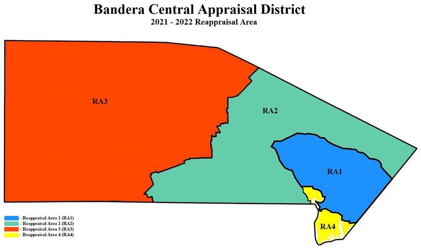
BCAD 2021-2022 Reappraisal Plan Page 9 of 30Data Resources The Appraisal District employs several methods of identifying properties that require inspection for the purpose of listing and appraising new improvements and updating relevant property characteristics. The primary sources of information used to identify those properties are as follows: Building Permits Building permits issued by the City of Bandera, electrical connection requests through the Bandera Electric Cooperative and well/septic permits issued by Bandera County. Copies of these permits are collected monthly and the applicable accounts are coded for inspection by an appraiser in PACS. State & County Records Ownership information, copies of plats and surveys, and DBA filings are obtained from deed records maintained in the Bandera County Clerk’s office. Reports of mobile home movement information, ownership transfers and installation records are collected from the Texas Department of Housing and Community Affairs (TDHCA). Reports of recently assigned 911 addresses are collected from the Bandera County Rural Addressing Department. Certificates of Occupancy are collected from the City of Bandera. Sales Tax Permit reports and local hotel/motel occupancy tax reports are requested from the Texas Comptroller. Renditions Real Property Renditions, Business Personal Property Renditions, and Real Property Inventory Renditions are filed by property owners and reviewed annually. Monthly and annual vehicle declarations are submitted by local motor vehicle and equipment dealers. Unrecorded Contracts for Deed are provided by grantors and grantees of the transactions. Sales Property owner (buyer & seller) surveys, online sales listings, realtor reports, fee appraisals and MLS data provided by property owners are collected and processed as they are submitted. Publications The district subscribes to multiple resources for appraisal information. The following is a list of frequently used materials: Texas Hotel Performance Fact Book, Marshall Valuation Service, and the Motor Vehicle Registration by Just Texas. PLANNING AND ORGANIZATION Areas of Focused Reappraisal The International Association of Assessing Officers, Standard on Mass Appraisal of Real Property, 4.8 - Frequency of Reappraisals, specifies that the universe of properties should be re-inspected on a cycle of 4-6 years. The re-inspection includes the remeasurement of at least two sides of each improved property and that current market value implies annual assessment of all property. Annual assessment does not necessarily mean that each property must be inspected each year. Physical reviews to correct data errors and property characteristics should be updated at least every 3 years. Additionally, the use of aerial photography such as Pictometry ChangeFinder on a three-year cycle can be utilized to meet this requirement. The district has gone through personnel and office changes over the last several years and physical inspections lagged in some areas. This biennial there will be three targeted areas for physical inspections. The first area will be the district’s review of property utilizing updated Pictometry photography and the Pictometry ChangeFinder system. The ChangeFinder system is software that detects changes in structures; it finds properties that had structures added, modified, or deleted. After reviewing properties with Pictometry software, appraisers follow up with field inspections as necessary for individual properties. The annual re-inspection BCAD 2021-2022 Reappraisal Plan Page 10 of 30
requirements for the 2021 and 2022 tax years are identified by property type and property classification and are
scheduled on the calendars of appraisal events. The target time frame is to work through the changes in the office
in the summer of 2021 and begin field work for the identified properties in the fall of 2021. It is expected that the
field work for this will continue into 2022.

The second area is properties that were not physically inspected in previous reappraisal plans. A listing of
properties will be developed in the summer of 2020 targeting properties for inspection. The listing will be
generated by neighborhood. Inspections of these properties will begin in the fall of 2020 and it is anticipated that
these inspections will continue through 2021.

The third area of targeted properties are properties that have been flagged for reinspection. Reasons for being
flagged include permits, utility connections reports, requests from property owners, and appraiser discovery. The
number of flagged properties has been about 2000 per year in recent years.

Appraisal Frequency and Methodology
Residential Property

    a. Single-Family Residences

Appraisals for single-family residences are derived by using the market sales approach as the model for valuation.
The master residential valuation schedule is annually updated by collecting sales of residential properties for the
prior 12 months. These confirmed sales are reviewed for validity and any sales that are considered non-market
transactions are removed from the study. Examples of non-market transactions are foreclosure sales and
transactions between friends and relatives.

All sales that have been evaluated and determined to be indicative of true market value transactions are then
grouped according to the quality class that has been assigned to the residence. Once all sales are grouped, a sales
ratio study is conducted for each quality group of sales. The sales ratio study is a simple and straightforward
exercise in mathematics: the prior year appraisal for each individual property included in the study is divided by
the sales price of that property. The result is a ratio expressed as a percentage. If the prior year appraisal is less
than the sales price, then the result will be a percentage less than 100%. If the prior year appraisal is greater than
the sale price, then the result will be a percentage greater than 100%. The purpose of the sales ratio study is to
determine how accurately prior year appraisals reflect market values of the properties within the study.

Once all the ratios have been determined, an average and median ratio is calculated for each quality class. In
addition, a weighted mean is calculated for each quality class as well as for the entire study. The weighted mean
for a quality class is calculated by summing the appraisals for each property within each quality class, then
summing the sales prices for the same properties and then dividing the first result by the second. The weighted
mean for the entire study is calculated by summing the appraisals of all properties (regardless of class), then
summing the sales price for all properties and then dividing the first result by the second.

The resulting statistics of average ratio, median ratio, and weighted mean ratios are then used to conclude the
amount (on a percentage basis) that the master residential valuation schedule will be adjusted. The primary
statistic that is used when arriving at this conclusion is the weighted mean for the entire study. If this weighted
mean is less than 100%, then it can be concluded that market values are increasing, therefore, it is necessary to
adjust the master residential valuation schedule upward in order to satisfy the statutory obligation to appraise
properties at 100% of market value. If the weighted mean is greater than 100%, then it can be concluded that
market values are decreasing, and it will be necessary to adjust the master residential valuation schedule
downward. The master residential schedule is compared to the national pricing guide Marshall & Swift.
Bandera CAD’s pricing schedules must be within 10% of the indicated Marshall & Swift values.

BCAD 2021-2022 Reappraisal Plan                                                                        Page 11 of 30
Once the master residential valuation schedule is updated within the appraisal software, appraisals of single-
family residences are updated based on the updated residential schedule values. Further appraisal analysis is then
performed by neighborhood. This analysis is performed to “fine tune” the appraisals and to determine if
properties within certain neighborhoods are selling at a premium or a discount when compared to the market as a
whole. Neighborhood analysis is performed by conducting ratio studies within individual, predetermined
neighborhoods. The results of the neighborhood ratio studies will aid in determining if the appraisals within the
neighborhood need to be adjusted downward or upward. Whichever the conclusion, all appraisals within a
neighborhood will receive a “mass adjustment” to increase or decrease the appraisal as deemed necessary from
the results of the neighborhood ratio study.
b. Multi-Family Residential
For multi-family properties such as duplexes, fourplexes, and apartment complexes, the sales comparison
approach appraisal model is used to arrive at an estimate of market value. However, when adequate sales are not
available to derive reliable appraisals, additional appraisal models will be implemented. Since these types of
properties are primarily owned for the purpose of income generation, the net income that a property produces is
an indication of its value, therefore, the valuation methods within the income approach to value is often times
used to determine the appraisal of the property. Lastly, if adequate sales or income information is not available,
the cost approach to value will be implemented to arrive at an indication of property value.
Rural, Commercial & Platted Residential Land
Residential land is appraised as though vacant using the market sales approach as the appraisal model for
valuation. The value of the land component of the total property appraisal is estimated based on available market
sales for comparable and competing land under similar usage. A comparison and analysis of comparable land
sales is conducted based on a comparison of land characteristics found to influence the market value of land
located in the area or neighborhood. When necessary, the land appraisal is adjusted for specific factors and
conditions that influence the value of the land. These factors include access, view, shape, size, topography, and
the propensity to flood. When necessary, abstraction and allocation methods will be used to ensure that estimated
land values reflect the contributory market value of the land to the overall property value.
According to accepted appraisal theory, only the income and sales comparison model are acceptable in
determining market value of land. The cost approach is not appropriate and therefore is never used. The sales
comparison approach is the most widely used method in determining market value, thus is the method that will be
implemented to derive appraisals of all types of land. In instances where the sales comparison and income
approach can be implemented, both methods will be used and the final assigned value will be determined by
which value best describes the market value of the land considering the particular characteristics of the subject
property.
Business Personal Property (non-industrial)
Several methods may be used in appraising market value for business personal property. Generally, the cost
approached is used due to the availability of information. Available cost schedules and depreciation schedules
will be used when appropriate by district appraisal staff to aid in developing valuations. These schedules are
normally in a cost per square foot format; however, some industry schedules are in an alternate per unit format.
The replacement cost new less depreciation (R.C.N.L.D.) can be developed from property owners reporting of
historical acquisition cost or from a schedule developed by appraisal staff. As well, national valuation guides and
actual sales information may be considered in the valuation process. The method used for this type of valuation is
often determined by which method considers the most information for the property being appraised.
Commercial Real Property
BCAD 2021-2022 Reappraisal Plan Page 12 of 30Among the three approaches to value (cost, income, and market), industrial properties are most commonly
appraised using replacement/reproduction cost new less depreciation models because of readily available cost
information. If sufficient income or market data are available, those appraisal models may also be used.
Industrial, Utility, and Mineral Property (real and personal property)
An appraisal firm, contracted by Bandera CAD, is responsible for identifying property and updating information
relating to existing accounts. Resources available for this process include those employed by Appraisal District
personnel and as discussed in sections A-C. Additional resources include information and reports provided by
various State and Federal regulatory agencies such as the Texas Railroad Commission, Texas Public Utility
Commission and the Federal Communications Commission.
Target Dates for 2021 and 2022
Mail Agricultural – Use Application resets January 31
Mail Homestead and Exemption resets January 31
Appraisal Field work completed March 31
Generate Notices for Printing May 01
Mail Notices of Appraisal Value May 07
Appraisal Review Board Begins June 07
Appraisal Review Board approve records July 18
Chief Appraiser certify Appraisal Roll July 24
Begin Next Year’s Field work August 01
Mail Wildlife Management Annual Reports (for current year) December 01
Mail BPP Renditions (for following year) January 04
MASS APPRAISAL SYSTEM
The district has been operating True Automation’s PACS appraisal software previously mentioned since 2006.
PACS enables the efficient entry, analysis, and export of appraisal data. All computer forms and procedures in
PACS are reviewed and revised as required. The following details these procedures as it relates to the 2021 and
2022 tax years.
Real Property Valuation
Revisions to cost models, income models, and market models are specified, updated, and tested each tax year.
Cost schedules are tested with market data (sales) to ensure that the appraisal district complies with Texas
Property Tax Code, Section 23.011. Replacement cost new tables as well as depreciation tables are tested for
accuracy and uniformity using ratio study tools and comparing cost data from recognized industry leaders, such as
Marshall & Swift.
Land tables are updated using current market data (sales) and then tested with ratio study tools. Value modifiers
are developed for property categories by market area and tested on a pilot basis with ratio study tools.
Income, expense, and occupancy data is updated in the income models for each market area and cap rate studies
are completed using current sales data. The resulting models are tested using ratio study tools.
Personal Property Valuation
Appraisals and schedules are updated using data received from renditions, discovery, and Appraisal Review
Board hearing documentation. Valuation procedures are reviewed, modified as needed, and tested.
Notice Process
BCAD 2021-2022 Reappraisal Plan Page 13 of 30Notices of Appraised Value (Tax Code, Section 25.19) are reviewed and edited for updates and changes approved by the chief appraiser. Updates include the latest version of the Comptroller’s Property Tax Remedies. Hearing Process Protest hearing scheduling for informal and formal Appraisal Review Board hearings is reviewed and updated as required. Standards of documentation are reviewed and amended as required. The appraisal district hearing documentation is reviewed and updated to reflect the current valuation process. DATA COLLECTION PROCEDURES Residential & Commercial Property Identifying and updating relevant characteristics of a property will be accomplished primarily through a physical inspection of the property. The inspecting appraiser will visit the property to collect relevant data about the property such as measurements of structures, construction type, quality of construction, completion of construction and physical deterioration, among other characteristics. The collection and recording of this data are done using standardized procedures outlined in Bandera CAD field appraisal manuals. The collected data is gathered by the inspecting appraiser, noted on field inspection sheets, or by using electronic field devices. This information is then entered or downloaded into the CAMA system. In addition, a GIS system equipped with aerial photography encompassing all properties within the district is used as a tool in identifying improvements that are not currently accounted for in the appraisals of properties. Rural, Commercial & Platted Residential Land Physical characteristics that influence land value include size, shape, soil type and topographic features (including floodplain). Resources such as aerial photography, ownership maps, subdivision plats, surveys, NRCS soils maps, USGS topographic maps, and FEMA flood maps are referenced to obtain or verify information relating to these characteristics for specific properties. Other conditions that influence value include location, access, frontage, and legal limitations such as zoning and easements. The resources listed above, along with street maps, zoning maps and ordinances, utility maps, deeds and other legal filings are used to identify and verify these conditions. In the appraisal process, appraisers, through sales analysis determine proper adjustments for the presence of such characteristics and conditions. The mapping resources discussed are integrated in the CAD’s Geographic Information System (GIS). Identification of specific characteristics will be done through review of relevant documents (see Section I) or through field inspections. Updating this information is done using standardized procedures outlined in Bandera CAD appraisal manuals. The reviewing appraiser will document necessary information and either update or submit the changes to data entry personnel to update the electronic record of the subject property. Business Personal Property Field staff inspect assigned areas to identify new businesses or changes in the size and scope of existing businesses. Appraisal District personnel review local publications for advertisements and notices of grand openings or closures. Which businesses or specific types of businesses that will be designated for inspection will be set out during development of the annual work plan for each year and will be determined using information obtained in the discovery process. Identifying and updating relevant characteristics of the subject property is accomplished through the discovery (see Section I) and inspection processes. Information the appraiser must identify and verify include: the type of property; the category (i.e. inventory, furniture, fixtures, machinery, or equipment); quality; density; original costs; year acquired; age; condition; and life expectancy. The appraiser identifies any property located at the BCAD 2021-2022 Reappraisal Plan Page 14 of 30
business that does not belong to the business owner. If this property is taxable (reference sec. 11.01 & 11.14 PTC)
the appraiser collects the pertinent information noted above, including the name and address of the owner of the
property. The collection and recording of this data are done using standardized procedures outlined in Bandera
CAD’s Business Personal Property Manual.

Industrial, Utility, and Mineral Property (real and personal property)
The Industrial, Utility and Mineral appraisal firm contracted by Bandera CAD is responsible for updating and
identifying relevant characteristics for this property type. Identifying and updating relevant characteristics of the
subject property is accomplished through the discovery (see Section 1) and inspection processes. After the
discovery, field and appraisal work is completed; the firm then manually enters the data into Bandera CAD’s
PACS database following procedures outlined in PACS and Bandera CAD manuals. Appraisal District personnel
also randomly verify the contracted appraisal firm’s work to verify accuracy as outlined in the utility contract.

PRODUCTION OF VALUES
Sources of Data
In terms of commercial sales data, Bandera CAD accesses and reviews the deeds recorded in Bandera County that
convey commercially classed properties. These deeds involving a change in commercial ownership are entered
into the sales information system and researched to obtain the pertinent sale information. Other sources of sale
data include the protest hearings process and local, regional, and national real estate and financial publications.

Cost Schedules
The cost approach to value is applied to improved real property utilizing the comparative unit method. This
methodology involves the utilization of national cost data reporting services as well as actual cost information on
local comparable properties whenever possible. Cost models are typically developed based on the Marshall &
Swift Valuation Service which indicates estimated hard or direct costs of various improvement types. Cost
models include the derivation of replacement cost new (RCN) of all improvements represented within the district.
These include comparative base rates, per unit adjustments, and lump sum adjustments for variations in property
description, design, and types of improvement construction. This approach and analysis also employ the sales
comparison approach in the evaluation of soft or indirect costs of construction.

Evaluating market sales of newly developed improved property is an important part of understanding total
replacement cost of improvements. What total costs may be involved in the development of the property, as well
as any portion of cost attributed to entrepreneurial profit can only be revealed by market analysis of pricing
acceptance levels. In addition, market related land valuation for the underlying land value is important in
understanding and analyzing improved sales for all development costs and for the abstraction of improvement
costs for construction and development. Time and location modifiers are necessary to adjust cost data to reflect
conditions in a specific market and changes in costs over a period of time. Because a national cost service is used
as a basis for the cost models, location modifiers and estimates of soft cost factors are necessary to adjust these
base costs specifically for various types of improvements located in Bandera County. Thusly, local modifiers are
additional cost factors applied to replacement cost estimated by the national cost service. Estimated replacement
cost new will reflect all costs of construction and development for various improvements located in Bandera CAD
as of the date of appraisal.

Accrued depreciation is the sum of all forms of loss of value affecting the contributory value of the
improvements. It is the measured loss against replacement cost new taken from all forms of physical
deterioration, functional obsolescence, and economic obsolescence. Accrued depreciation is estimated and
developed based on losses typical for each property type at that specific age. Depreciation estimates have been
implemented for what is typical of each major class of commercial property by economic life categories.
Estimates of accrued depreciation have been calculated for improvements with a range of variable years expected
life based on observed condition considering actual age. These estimates are continually tested to ensure they are

BCAD 2021-2022 Reappraisal Plan                                                                       Page 15 of 30
reflective of current market conditions. The actual and effective ages of improvements are noted in PACS.
Effective age estimates are based on the utility of the improvements relative to where the improvement lies on the
scale of its total economic life and its competitive position in the marketplace. Effective age estimates are
considered and reflected based on five levels or rankings of observed condition, given actual age.

Additional forms of depreciation such as external and/or functional obsolescence can be applied if observed. A
depreciation calculation override can be used if the condition or effective age of a property varies from the norm
by appropriately noting the physical condition and functional utility ratings on the property data characteristics.
These adjustments are typically applied to a specific condition adequacy or deficiency, property type or location
and can be developed via ratio studies or other market analyses.

The result of estimating accrued depreciation and deducting that from the estimated replacement cost new of
improvements indicates the estimated contributory value of the improvements. By adding the estimated land
value, as if vacant, to the contributory value of the improvements indicates a property value by the cost approach.
Given relevant cost estimates and market related measures of accrued depreciation, the indicated value of the
property by the cost approach becomes a very reliable valuation technique.

Income Models
The income approach to value is applied to those real properties which are typically viewed by market
participants as “income producing” and for which the income methodology is considered a leading value
indicator. The first step in the income approach pertains to the estimation of market rent on a per unit basis. This
is derived primarily from actual rent data furnished by property owners and from local market surveys conducted
by the district and by information from area rent study reviews. This per unit rental rate multiplied by the number
of units results in the estimate of potential gross rent.

A vacancy and collection loss allowance are the next item to consider in the income approach. The projected
vacancy and collection loss allowance is established from actual data furnished by property owners and local
market survey trends. This allowance accounts for periodic fluctuations in occupancy, both above and below an
estimated stabilized level. This feature may also provide for a reasonable lease-up period for multi-tenant
properties, where applicable. The market derived stabilized vacancy and collection loss allowance is subtracted
from the potential gross rent estimate to yield an indication of estimated annual effective gross rent to the
property.

Next, a secondary income or service income is considered and, if applicable, calculated as a percentage of
stabilized effective gross rent. Secondary income represents parking income, rent escalations, reimbursements,
and other miscellaneous income generated by the operations of real property. The secondary income estimate is
derived from actual data collected and available market information. The secondary income estimate is then
added to effective gross rent to arrive at an effective gross income, when applicable.

Allowable expenses and expense ratio estimates are based on a study of the local market, with the assumption of
prudent management. An allowance for non-recoverable expenses such as leasing costs and tenant improvements
may be included in the expenses. A non-recoverable expense represents costs that the owner pays to lease rental
space. Relevant expense ratios are developed for different types of commercial property based on use and market
experience. For instance, retail properties are most frequently leased on a triple-net basis, whereby the tenant is
responsible for all operating expenses, such as ad valorem taxes, insurance, and common area and property
maintenance. In comparison, a general office building is most often leased on a base year expense stop. This
lease type stipulates that the owner is responsible for all expenses incurred during the first year of the lease. As a
result, expense ratios are implemented and estimated based on observed market experience in operating various
types of commercial property.

BCAD 2021-2022 Reappraisal Plan                                                                        Page 16 of 30
Another form of allowable expense is the replacement of short-lived items (such as roof or floor coverings, air
conditioning or major mechanical equipment or appliances) requiring expenditures of lump sum costs. When
these capital expenditures are analyzed for consistency and adjusted, they may be applied on an annualized basis
as stabilized expenses. When performed according to local market practices by commercial property type these
expenses, when annualized, are known as replacement reserves. For some types of property typical management
does not reflect expensing reserves and is dependent on local and industry practices.

Subtracting the allowable expenses (inclusive of non-recoverable expenses and replacement reserves when
applicable) from the annual effective gross income yields an estimate of annual net operating income to the
property.

Return rates and income multipliers are used to convert operating income expectations into an estimate of market
value for the property under the income approach. These include income multipliers, overall capitalization rates,
and discount rates. Each of these multipliers or return rates are considered and used in specific applications.
Rates and multipliers may vary between property types as well as by location, quality, condition, design, age, and
other factors. Therefore, application of the various rates and multipliers must be based on a thorough analysis of
the market for individual income property types and uses. These procedures are supported and documented based
on analysis of market sales for these property types.

Capitalization analysis is used in the income approach models to form an indication of value. This methodology
involves the direct capitalization of net operating income as an indication of market value for a specific property.
Capitalization rates applicable for direct capitalization method and yield rates for estimating terminal cap rates for
discounted cash flow analysis are derived from the market. Sales of improved properties from which actual
income and expense data are obtained provide a very good indication of property return expectations a specific
market participant is requiring from an investment at a specific point in time. In addition, overall capitalization
rates can be derived and estimated from the built-up method (band-of-investment). This method relates to
satisfying estimated market return requirements of both the debt and equity positions in a real estate investment.
This information is obtained from available sales of property, local lending sources, and from real estate and
financial publications.

Rent loss concessions are estimated for specific properties with vacancy problems. A rent loss concession
accounts for the impact of lost rental income while the building is moving toward stabilized occupancy. The rent
loss is calculated by multiplying the rental rate by the percent difference of the property’s stabilized occupancy
and its actual occupancy. Build out allowances (for first generation space or retrofit/second generation space as
appropriate) and leasing expenses are added to the rent loss estimate. The total adjusted loss from these real
property operations is discounted using an acceptable risk rate. The discounted value (inclusive of rent loss due to
extraordinary vacancy, build out allowances, and leasing commissions) becomes the rent loss concession and is
deducted from the value indication of the property at stabilized occupancy. A variation of this technique allows a
rent loss deduction to be estimated for every year that the property’s actual occupancy is less than stabilized
occupancy.

Sales Comparison (Market) Approach
Although all three of the approaches to value are based on market data, the Sales Comparison Approach is most
frequently referred to as the Market Approach. This approach is utilized not only for estimating land value but
also in comparing sales of similarly improved properties to parcels on the appraisal roll. As previously discussed
in the Data Collection / Validation section of this report, pertinent data from actual sales of properties, both vacant
and improved, is pursued throughout the year in order to obtain relevant information which can be used in all
aspects of valuation. Sales of similarly improved properties can provide a basis for the depreciation schedules in
the Cost Approach, rates and multipliers used in the Income Approach, and as a direct comparison in the Sales
Comparison Approach. Improved sales are also used in ratio studies, which afford the appraiser an excellent
means of judging the present level and uniformity of the appraised values.

BCAD 2021-2022 Reappraisal Plan                                                                        Page 17 of 30
Final Valuation Schedules
Based on the market data analysis and review discussed previously in the cost, income and sales approaches, the
cost and income models are calibrated and finalized. The calibration results are keyed to the schedules and
models in the PACS system for utilization on all commercial properties in the district. Market factors reflected
within the cost and income approaches are evaluated and confirmed based on market sales of commercial and
industrial properties. The appraisers review the cost, income, and sales comparison approaches to value for each
of the types of properties with available sales information. The final valuation of a property is estimated based
on reconciling these indications of value considering the weight of the market information available for evaluation
and analysis in these approaches to value.

Statistical and Capitalization Analysis
Statistical analysis of final values is an essential component of quality control. This methodology represents a
comparison of the final value against the standard and provides a concise measurement of the appraisal
performance. Statistical comparisons of many different standards are used including sales of similar properties,
the previous year’s appraised value, audit trails, value change analysis and sales ratio analysis.

Appraisal statistics of central tendency and dispersion generated from sales ratios are calculated for each property
type with available sales data. These summary statistics including, but not limited to, the weighted mean provide
the appraisers an analytical tool by which to determine both the level and uniformity of appraised value of a
particular property type. The level of appraised values can be determined by the weighted mean for individual
properties within a specific type and a comparison of weighted means can reflect the general level of appraised
value.

The appraisers review every commercial property type annually through the sales ratio analysis process. The first
phase involves ratio studies that compare the recent sales prices of properties to the appraised values of the sold
properties. This set of ratio studies affords the appraiser an excellent means of judging the present level of
appraised value and uniformity of the appraised values. The appraiser, based on the sales ratio statistics and
designated parameters for valuation update, makes a preliminary decision as to whether the value level of a
particular property type needs to be updated in an upcoming reappraisal, or whether the level of market value is at
an acceptable level.

Potential gross rent estimates, occupancy levels, secondary income, allowable expenses, net operating income and
capitalization rate and multipliers are continuously reviewed. Income model estimates and conclusions are
compared to actual information obtained on individual commercial and industrial income properties during the
protest hearings process, as well as with information from published sources and area property managers and
owners.

INDIVIDUAL VALUE REVIEW PROCEDURES
Field Review
The date of last inspection, extent of that inspection, and the Bandera CAD appraiser responsible are listed in the
CAMA system. If a property owner disputes the Bandera CAD's records concerning this data in a protest hearing,
PACS data and values may be altered based on the credibility of the evidence provided. Normally, a new field
check is then requested to verify this information for the current year's valuation or for the next year's valuation.
In addition, if a building permit is filed for a particular property indicating a change in characteristics, that
property is added to a work file for review.

A major effort is made by appraisers to field review as many properties as possible or economic areas
experiencing large numbers of remodels, renovations, or retrofits, changes in occupancy levels or rental rates, new
leasing activity, new construction, or wide variations in sale prices. Field review of real property accounts is

BCAD 2021-2022 Reappraisal Plan                                                                      Page 18 of 30
You can also read