Biodiversity and Connectivity Evaluation for Portions 61 and 63 of Uitzicht 216 - Type the document subtitle
←
→
Page content transcription
If your browser does not render page correctly, please read the page content below
NMS

Biodiversity and Connectivity Evaluation
 for Portions 61 and 63 of Uitzicht 216
       [Type the document subtitle]
                 Peet Joubert
                  8/2/2019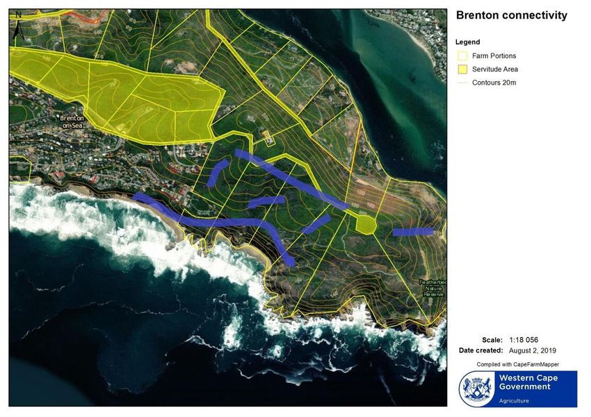
Contents
 I: Introduction. .................................................................................................................................... 3
 II:Vertebrate Fauna. ............................................................................................................................ 3
 III:Vegetation....................................................................................................................................... 4
 IV:Connectivity in the broader landscape ........................................................................................... 5
 V:Conservation options....................................................................................................................... 5
    a. Private ownership. No official status. ......................................................................................... 5
    b. Zoned Municipal open space III . ................................................................................................ 5
    c. Contracted Provincial Private Nature Reserve.(Stewardship agreement) .................................. 6
 VI:Connectivity in the landscape......................................................................................................... 6
    VI.1:Municipal Road servitude. ....................................................................................................... 6
    VI.2:Brenton extension development. ............................................................................................ 6
    VI.3:Featherbed Private Nature Reserve. ....................................................................................... 6
    VI.4:Brenton Blue Butterfly Reserve.(Special reserve in terms of Environment Management Act
    1989,( Act 73 of 1989)..................................................................................................................... 6
 VII:Placement of accommodation elements in the landscape. .......................................................... 7
 VII .1 Discussion of unit placement. .................................................................................................... 8
 VII.2 Some possible mitigation measures. ......................................................................................... 9
    VII.2 a.Design and construction. ................................................................................................... 10
    VII.2 b.Water issues. ..................................................................................................................... 10
    VII.2 c. Light .................................................................................................................................. 10
    VII.2 d. Movement and sound....................................................................................................... 10
 VIII: ADDENDA................................................................................................................................... 11

                                                                                                                                                      2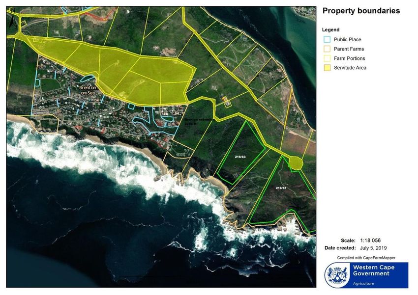
DRAFT 1

Biodiversity and Connectivity Evaluation
for Portions 61 and 63 of Uitzicht 216
                                         Produced for A west.

                                              2019-07-14

                        By Peet Joubert Environmental Management Services

                                        And Benjamin Walton

I: Introduction.
The owner of Portion 61 and 63 of Farm Uitzicht requested an environmental evaluation of the
property in order to make the best choice towards preserving the biodiversity of this section of the
Western Heads. There is a need to establish what viable biodiversity corridors are available, and if
possible, predict the possible negative impacts that small development nodes could have on the
general biodiversity functionality of the property.

There are already a couple of nature reserves on the Western Heads and it would be advantageous
for the conservation of Garden route onshore vegetation mosaic of this section of coastal
vegetation.

The Brenton Blue butterfly reserve (which is mainly on Municipal land and the public servitude along
the Brenton ridge), as well as the Whale rock private nature reserve (Zoned Open space III) will allow
reasonable connectivity over an area of km, to the west of the applicant’s properties.

See appendix please for proclamation.

II:Vertebrate Fauna.
The western Heads have a reasonably representative sample of the fauna of the Garden Route, even
though the peninsula has a somewhat restricted connection with the larger component of the
ecosystem further to the north and west.

The following animals may occur in the area, although the recent fires would have had an impact on
numbers and distribution.

The list is just indicative and does not represent the present situation on the ground.

Bushbuck (Trachelapus scriptus)

Grey Duiker (Sylvicapra grimmia)

Steenbok (Raphicerus campestrus)

Grey mongoose (Herpestes pulverulentus)

Water mongoose (Atilax paludinosus)

                                                                                                       3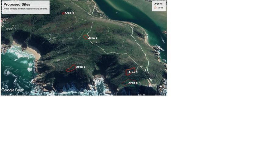
Honey badger (Melivora capensis)

Cape Clawless Otter (Aonix capensis)

Spotted Genet (Genetta genetta)

Porcupine (Hystrix africaeaustralis)

Caracal (Felis caracal)

Dassie (Procavia capensis)

Cape dune mole rat (Bathyergus suillus)

Amongst the various species of moles that should occur in the area, the most notable is perhaps the

Duthie’s golden mole (Chlorotalbia duthiei)

Reptiles.

Girdled lizard (Cordylis cordilus)

Dwarf chameleon (Bradipodion

Puff Adder (Bitis arietans)

Night Adder (Causus rhombiatus)

Cape cobra (Naja nivia)

Slug eater (Duberria lutrix)

Boomslang (Dispholidus typus)

Red lip herald (Crotapholpeltis hotamboeia)

Angulate tortoise (Chersina angulata)

III:Vegetation.
The recent fires that swept through the Western Heads, burnt away a large portion of the very old
senescent vegetation ,leaving very little of the original fynbos and forest elements to evaluate.

Forest remnants survived in some of the valleys and serves well as a refuge.

Dense stands of alien invasive vegetation appeared after the fires, suppressing a lot of the natural
re-generation that would have taken place.

Pioneer vegetation appeared in the areas where alien vegetation regeneration was suppressed or
removed early on.These elements were inspected and reported on in the vegetation section of the
report.

Please also see the vegetation report.

                                                                                                       4
IV:Connectivity in the broader landscape
The individual farm portions are not fenced or are inadequately fenced due to the difficult terrain of
the western Heads. Some fencing has burned down with the June 2017 wildfires and has not been
replaced yet. There are ongoing discussions amongst land-owners, to drop existing inner fences in
order to enhance animal movement.
Connectivity is thus not really influenced by the fencing due to the many gaps n the fencing and the
topography of the area.
The terrain consists of steep vegetated valleys, ridges and a relatively narrow plateau along the
Brenton ridge. Larger animals tend to move along the naturally protected pathways when they are
aware of disturbance factors such as human activity. The relatively low density of built structures
present on the western Heads, as well as the limited human activities does not seem to inhibit any
animal activity.
Both properties have adequate shelter as well as open corridors for movement of choice even
though the recent fires had largely destroyed some of the forest elements in two of the shallow
valleys.
It is possible for animals to move unhindered from the Brenton Blue Butterfly reserve all the way to
the two properties (Sections 61 and 63). The coastal slope below Brenton extension is vegetated and
undisturbed except for a few narrow footpaths.
Connectivity along this section is considered as favourable .
Along the Brenton Ridge, there is a public servitude with a very narrow road leading the properties
towards the west. There is adequate shelter along the whole ridge to ensure satisfactory
connectivity.
All of the small valleys running from the Brenton ridge towards the coastline will serve as very good
pathways between the coast and the ridge.
V:Conservation options.
a. Private ownership. No official status.
The present and previous owners had created de-facto nature reserves by leaving the landscape
undisturbed, but growing hunger for development in the Knysna area could in future alter this
situation. It is therefore preferable to create a more secure situation.
b. Zoned Municipal open space III .
The present municipal zoning is” Agiculture “and this situation does not allow the owner to erect
more buildings on the property than the present limited permission. The property is not ideal to try
and generate income through agricultural activities.
In terms of Municipal zone “Open Space III ”, there is a little more leeway to create some income
generating possibilities through tourism oriented activities.
5c. Contracted Provincial Private Nature Reserve.(Stewardship agreement)
Under the Stewardship programme of CapeNature, the land-owner enters a in conservation
management programme of his property for a fixed period. This agreement secures the property for
the conservation of the landscape, but provides for certain types of low impact activities on the
property under contract.
Other conservation areas.
The Western Heads already have other properties under some form of conservation management.
This fact makes it possible to predict that possible post-fire population re-colonisation is most likely
to happen.
VI:Connectivity in the landscape.
The two properties form part of about eight land parcels on the peninsula where vegetation and
landscape has not been hugely transformed. Vegetation recovery after the recent fires shows
healthy recovery and satisfactory diversity.
It is unknown what terrestrial animal population densities were before the fire, but there are signs
that some animals such as Bushbuck and Duiker are returning. (More effective monitoring is
necessary to determine the size and nature of the present animal population.)
VI.1:Municipal Road servitude.
There is a road servitude running along the crest of the Western Head that creates a good landscape
connectivity opportunity at present. The actual road is narrow and vegetation encroaches tightly
along most of the road.(see picture)
VI.2:Brenton extension development.
The Brenton extension development, west of the discussion area has a substantial undeveloped
section (southern right conservancy)managed as a conservation area.
VI.3:Featherbed Private Nature Reserve.
Featherbed lies to the North and East of the sections under discussion, and is probably the oldest
Private Reserve in the area. The present owners have indicated willingness to drop fences between
the properties in order to enhance connectivity and management efforts.
VI.4:Brenton Blue Butterfly Reserve.(Special reserve in terms of Environment Management Act 1989,(
Act 73 of 1989)
The Butterfly reserve lies to the West of the property and extends eastwards towards the
properties. The Municipal road reserve forms a connecting line of vegetation between the east and
west.
It encompasses erven 434,435,436,437,438,439, 440,442,444,445,446,447,451.
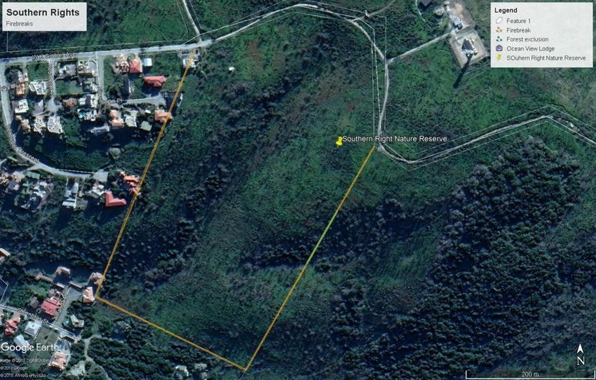
6Southern Right Reserve. Open space III zone
VII:Placement of accommodation elements in the landscape.
Placement of the proposed habitation units within the landscape will have an impact on the
movement of animals to a certain extent no matter how carefully they are positioned.
The principles of “touch the earth lightly” as advocated by conservation authorities and
environmental planners should necessarily apply in this application.
Four areas have been identified where dwelling units may be placed without catastrophic impacts on
the ecological functioning of the peninsula.
These areas have been identified solely on their possible impacts on connectivity in the landscape
and on the survival of smaller vegetation units contained within the boundaries of the properties.
Determination of impacts of waste water disposal and possible fire protection methods have not
been investigated.
The following parameters were used in the determination of the possible utilisation sites.
1. Visual Impacts.
Units must not be visible from the sea, or visual impact must be low.
Colours of units must blend in with the surrounding environment.
Impact of Skyline placement .
72. Environmental impacts.
Building (development) footprint size.
Placement of access roads and footpaths.
Vulnerable vegetation units.
Emerging vegetation.
Known and estimated positions of animal movement corridors.
Known and estimated ecological connectivity pathways.
Possible anthropomorphical influences such as light , noise and movement.
VII .1 Discussion of unit placement.
VII .1 a.Position. a.(Portion 61)
This position is near the steep coastal cliff on the southern side of portion 63 similar to the existing
building on the eastern boundary of the property. Owner considers it a possibility for a single unit.
Recommendation.
This area should be avoided due to the proximity to the cliff edge where it could have an impact on
the coastal birds nesting on the cliffs below the old wave platform.
Visibility from the sea will be high. Visibility from neighbouring properties will be low.
VII .1 b.Position 1.Portion 61.
This proposed area faces slightly south-west and sits about 150 m from the cliff and straddles a
shallow fold in the coastal dune. A portion of the coastal dune forest (Milkwood, Candlewood and
Coastal camphor dominated) was destroyed by the fire. Limited re-sprouting of Tarchonanthus and
Pterocelastrus have taken place, but the very hot fire caused a major die-back of the rest of the
forest elements.
Recommendation
An area on this slope, facing seawards could accommodate a few units, provided that enough space
is kept undeveloped to provide for animal movement in the north – south direction.
Soil erosion may be a problem due to the sandy nature of the soil, but there are engineering
methods available to resolve any problems in this regard.
Storm water should be diverted from the access roads at regular intervals, or should be channelled
into storage units.
Visibility from the sea should be fairly low. Visibility from adjacent properties will be low.
VII .1 c.Position 2 Portion 61
This area to the south and north-east of the access road, is relatively level and should not be too
visible from areas further to the west along the coast.
Vegetation on this site was damaged by fire and is slowly recovering with an abundance of pioneer
vegetation. Placement of the access road and dwelling units should be carefully examined before
construction, in order to salvage any possible rare plants.
8Recommendation.
This site lends itself favourably for the positioning of a number of dwelling units.
VII .1 d.Position 3. Portion 61
This area would be placed behind the sandy ridge running above the coastal cliff. The red sandy soil
surface is underlain by calcitic layers with deeper TMS foundation.
At present the vegetation is dominated by a very dense young Rooikrans population that is being
removed. The remnants of previous vegetation are mostly Coastal Camphor trees
(Tarchonanthus )Candlewood (Pterocelastrus) and White milkwood (Syderoxylon)
If chosen carefully, visibility from the sea will be very low and visibility form adjacent areas will be
medium low.
The road access to this site will be the longest that has to be constructed.
Recommendation.
Siting of units in this area should be carefully considered, avoiding steep sandy slopes.
The relatively longer road access would count against this site in comparison to the other areas.
Placing units in this area may have an impact on coast- to - ridge connectivity, however, a low
number of units and relatively low activity should not impair landscape connectivity.
VII .1 e.Position 4. Portion 63
The forest on this property escaped most of the fire damage, except for the existing dwelling that
burnt down completely.
The remaining footprint of the original dwelling provides a good base for new structures.
Any additional dwellings/cabins should ideally be erected in the forest/fynbos interface to provide
viable forest experience without damaging the forest structure any further.
The particular valley in which the forest occurs splits into two towards the ridgeline.
Adequate shelter exists for larger animals to move while smaller animals tend to ignore human
presence, particularly in these forest edge environments.
Recommendation.
This particular site has been used before for a structure with a large footprint.
A few smaller lightweight structures along the forest fringe should provide adequate space for
animal movement.
Care should be taken not to disturb the forest floor.
Rain water runoff should be collected for domestic use and not dumped in the forest where it may
change the existing water regime to the detriment of the forest.
VII.2 Some possible mitigation measures.
There are a couple of mitigation elements that can be applied to lessen human impacts on the
natural environment, however, the extent of the remainder of the Western Heads conservation
9footprint, is rather limited in the broader landscape. Human impacts of previous development have
limited the number of options that can be applied to make the conservation management of the
area truly meaningful
VII.2 a.Design and construction.
Where possible, screening should be incorporated in the design of dwellings, in order to screen light
and movement to lessen the impacts of human activity in the landscape.
VII.2 b.Water issues.
Waste water disposal should be treated innovatively and responsibly to avoid polluting underground
water sources.
Rain water collection from roofs should be done as far as possible.
It is therefore important to choose the site for clusters carefully, keeping in mind that the access
roads should be as short as possible and the surface should be as narrow and constructed to allow
water to seep into the substrate as soon as possible in order to avoid runoff erosion.
Where possible, road runoff should be collected for use on the estate.
VII.2 c. Light
Placing of external light should be carefully considered in order to keep light disturbance as limited
as possible. Low intensity, downward facing light sources should be strategically placed for the most
benefit in order to limit the number of points of impact.
Motion activated light sources should be used on outside fittings where possible.
It is expected that light may have an impact on insect life being drawn towards the light source.
However, the impact should be low provided that
the number of units are controlled and light sources are well chosen and positioned.
VII.2 d. Movement and sound.
Most of the fauna on the penisnsula have been subjected to human activity of some sort or the
other over extended time periods.
Provided that the present expected usage of the area remains the same, the expected impact will be
low.
--------------------------------------------------------------------------------------------------------------------------------------
10VIII: ADDENDA.
VIII:1.Brenton Blue reserve.
11VIII:2.Possible Biodiversity Corridors.
12VIII:3.Property boundaries.
13VIII:4 .Brenton Extension. Zone III reserve
k
14VIII:5. Areas Examined for possible placement of dwelling units .
15You can also read