BIOREGIONAL APPROACH TO INTEGRATING TRANSPORT NETWORKS AND NATURAL AREAS IN THE LAZIO REGION COASTAL AREA, ITALY - WIT Press
←
→
Page content transcription
If your browser does not render page correctly, please read the page content below
Coastal Cities and their Sustainable Future III   95

         BIOREGIONAL APPROACH TO INTEGRATING
       TRANSPORT NETWORKS AND NATURAL AREAS
        IN THE LAZIO REGION COASTAL AREA, ITALY
                               ALBERTO BUDONI & VALERIO MAZZESCHI
                                   La Sapienza University of Rome, Italy

                                                ABSTRACT
“Bioregion”, a term coined by Peter Berg in 1977, was improved by Alberto Magnaghi, who defined it
as the space for developing new relationships of coexistence between the inhabitants–producers and the
territory of a region. Therefore, bioregion is a tool for rethinking regional planning, no longer as the
sum of different sectorial planning exercises, but as a “transdisciplinary planning” approach that
considers all of a territory’s aspects. This approach is related to EU policies for Integrated Coastal Zone
Management (ICZM) and the protection of maritime and coastal areas. This paper presents a case study
on the coastal areas of the Lazio region of Italy which have a great many natural areas but which is also
one of the most anthropized areas in the region. Indeed, due to the rising population, many interventions
in the coastal areas resulted in the transformation of natural zones into urban areas. One effect has been
urban sprawl and the related lack of capillarity of the public transport network. The result was that
many ecosystems and natural areas were fragmented, losing their biodiversity. With a view to
reconnecting these fragmented areas, this paper discusses a new regional scenario based on enhancing
the linkages between land transport networks and the maritime gateway. In this scenario, railway
corridors would stimulate a new organisation for the region’s settlements by representing not only the
network connecting the bioregion’s cities and towns but also the cornerstones for the environmental
regeneration of the coastal areas.
Keywords: bioregion, railways, ports, ICZM, transport corridors.

                                     1 INTRODUCTION
The globalization of markets marked by increases in goods production and tourist flows has
determined and will continue to determine higher volumes of maritime transport. In the
European context, the increment is likely to be increasingly strong due to the combination of
two factors: (1) the EU’s transport policies as laid down in the 2001 white paper [1] where
the creation and strengthening of “motorways of the sea” are seen as one of the pillars for
transport efficiency and environmental sustainability due to their key role in furthering
intermodality and the decongestion of road infrastructures for the movement of goods; and
(2) the new silk route called the “Belt and Road Initiative (BRI)” under China’s policies for
commercial and infrastructural expansion, which has, as one of its fundamental pillars, a
focus on maritime transport, the organization of efficient port areas for container traffic, and
full integration with road and railway networks. The pressure on coastal areas will therefore
increase, due not only to the impact of rising goods and passenger flows, but also to the need
to upgrade port infrastructures both at sea and on land, including the roads and railways in
the hinterland and hence the settlement system as a whole. These pressures will join the
broader and more generalized ones that have characterized the European coasts in recent
decades. As noted in 2007 by the European Commission: “Population growth in coastal
regions and islands has been double the EU average over the last decade. Coastal
communities are also the destination of the majority of tourists in Europe, making the need
to reconcile economic development, environmental sustainability and quality of life
particularly acute in these regions” [2]. The EU’s attention to coastal strips was already
evident in 1995 [3], but it was first developed in an expert document on general principles

     WIT Transactions on The Built Environment, Vol 188, © 2019 WIT Press
     www.witpress.com, ISSN 1743-3509 (on-line)
     doi:10.2495/CC190091
96 Coastal Cities and their Sustainable Future III
and political reflections [4]. Then a Recommendation of the European Parliament and of the
Council of 2002 [5] set the guiding concepts “for a strategic approach based on an ecosystem
approach of the natural resources of both the marine and terrestrial components of the coastal
zone and a broad overall perspective (thematic and geographic) which will take into account
the interdependence and disparity of natural systems and human activities with an impact on
coastal areas” [5]. Based on these guiding concepts, and interacting with other sectoral norms
including the Marine Strategy Framework Directive [6] which reiterates the need for an
ecosystem-based approach to the management of human activities and delimits the marine
regions or sub regions, the EU developed a directive establishing the framework for maritime
spatial planning (MSP) [7].
Member States had to comply with this Directive by 18 September 2016. It states that the
maritime spatial plans shall be established as soon as possible and at the latest by 31 March
2021. Through these plans, “Member States shall aim to contribute to the sustainable
development of energy sectors at sea, of maritime transport, and of the fisheries and
aquaculture sectors, and to the preservation, protection and improvement of the environment,
including resilience to climate change impacts. In addition, Member States may pursue other
objectives such as the promotion of sustainable tourism and the sustainable extraction of raw
materials” [7].
The Directive is a step forward in the planning of maritime space, but not decisive for
coastal zone planning. In fact, coastal areas are excluded even though they were part of it at
the beginning of the approval process. The Member States insisted on maintaining their
competence and full discretion over the management of their coasts and in particular over
coastal urban planning [8]. This once again demonstrates the EU’s difficulty in developing
integrated policies, particularly when dealing with aspects of land-use planning in urban
areas. It is therefore not surprising that attention to the environmental aspects of the
motorways of the sea in the Detailed Implementation Plan of the European Coordinator [9]
is limited to the environment within the ports and to the pollution caused by the ships; the
coastal environment in terms of its relationship both with the maritime space and with the
hinterland.
2 THE DIFFICULTIES OF INTEGRATED MANAGEMENT OF THE
COASTS AND BIOREGIONAL CONCEPTION
Integration is not a problem only at the normative level, however; it is also a problem of
establishing its meaning. In fact, although integration has long been seen as necessary for
maritime and coastal planning in various international conventions (e.g. the United Nations
Framework Convention on Climate Change of 1992, and the Convention on Biodiversity,
especially the program entitled “Integrated Marine and Coastal Area Management (IMCAM)
approaches for implementing the Convention on Biological Diversity” of 2004 [10]), it is not
clear how this is to be done nor what it implies in the different contexts of MSP. Saunders et
al. [11] examined different dimensions of integration across several MSP case studies and
through an analytical framework which includes: cross-border (integration across
administrative borders), policy and sector integration (MSP aspirations to achieve balanced
outcomes of the environmental, social and economic pillars), stakeholders (how stakeholders
are engaged with during different MSP policy phases), knowledge (consideration of
platforms and processes that support data and knowledge coordination and sharing among
relevant authorities, sectors and levels), temporal integration dimensions (focus on how
marine planning seeks to consolidate “the now with the future”). What emerges from this
framework regarding different dimensions of integration “is that how they are interrelated in
practice is always contingent on the particular empirical setting, i.e. just because a wide range
WIT Transactions on The Built Environment, Vol 188, © 2019 WIT Press
www.witpress.com, ISSN 1743-3509 (on-line)Coastal Cities and their Sustainable Future III 97
of stakeholders participated in MSP does not necessarily mean that stakeholders were
influential or that different knowledge types were meaningfully considered in decision-
making” [11]. This specificity of contexts and processes is not easily standardized by using
software-based simulation and analytical tools since, although they are frequently mentioned
in the scientific literature on marine management approaches, these are still mainly used in
academic circles and have not yet found their way into everyday MSP practice [12].
Improving software-based, analytical tools and scientific knowledge in general is important
but it cannot be the only working guideline.
According to the analytical framework developed by Saunders et al., an integrated coastal
zone planning and management effort should:
define planning and management areas that are not determined by administrative
boundaries but rather by agreements and contracts with entities and actors (e.g. the
coastal contracts in France) [13];
develop planning strategies that set out a vision for the future development of a place in
ways that pursue environmental, social and economic objectives;
involve stakeholders interactively as from the start of the planning process, during public
meetings and using appropriate communications tools;
insert acquired knowledge into a GIS recognized by the various sectors and levels and
ask scholars, associations and inhabitants to help expand the information base in the
framework of an effective participatory process (PPGIS);
promote, wherever possible, studies with a transdisciplinary character designed to
overcome the barriers between the various disciplines and strengthen the holistic
interpretation of territorial systems;
consolidate “the now with the future” by designing territorial projects that use innovative
technologies in the feasibility studies of the works that compose the vision of the future
to be developed.
These ways to tackle integration issues, which the authors believe are widely shared
among those involved in spatial, regional and urban planning, are not, however, enough to
address what many call a new era of urbanization. A clearly regionalized urban era [14] where
the urban and regional realities, previously distinguished from each other, are merging within
a dynamic involving a concentration of prestigious functions in urban areas and the expansion
of urban sprawl in the plains and on the coasts. It is necessary to combine the interpretative
utility of the concept of the urban region with a co-evolutionary vision between culture and
nature, with a view to detecting lasting relationships between human settlements and the
environment; to this end, it is possible to apply the concept of bioregion. A concept that can,
through rediscovery and redefinition, become one of the reference points for rethinking the
problems of contemporary territorial transformations. It is noteworthy that the first definition
of bioregion formulated by Berg and Darsmann [15] did not focus on ecological determinism,
but rather on an integrated vision of natural features and of how communities have
historically interpreted their relations with the environment. Indeed, while it is true that
physical abiotic and vegetal features prevail in the initial delimitation of a bioregion, the final
result is closely linked to the boundaries that the inhabitants, themselves, recognise as their
living environment. Even in the most recent formulations of the concept of bioregion, the
latter is defined in terms both of its ecological and human systems [16]. In the Italian context,
Magnaghi has re-proposed a bioregionalist approach to territorial planning [17] whose
characterizing element is the affirmation that, to obtain lasting equilibrium between human
settlement and environment or a bioregion capable of supporting itself, it is necessary to
WIT Transactions on The Built Environment, Vol 188, © 2019 WIT Press
www.witpress.com, ISSN 1743-3509 (on-line)98 Coastal Cities and their Sustainable Future III
develop new forms of co-evolutionary relationships between inhabitants/producers and the
territory, based on the care of its assets considered as common goods. Further, to improve
the capacity of inhabitants to recognize the territorial heritage, both physical and immaterial
(social relations), the delimitation of a bioregion can become a fundamental factor of cultural
growth and civic awareness, able (for example) to define a reference space for relationships
between the maritime space and the coastal strip and between the latter and its hinterland. A
relationship in the latter case that is not, as often understood, limited to the narrow strip
parallel to the shoreline but that comprises all the systemic components that influence its
conformation and the quality of its ecosystems, starting with the hydrographic network.
3 THE RELATIONSHIP BETWEEN THE MOTORWAYS OF THE SEA AND
COASTAL MANAGEMENT TOOLS IN THE ITALIAN CONTEXT
In post-World War II Italy, the coasts were basically seen as summer leisure venues and the
state-owned beaches were occupied by private concerns who altered them radically by
building second homes or, in the south, by illegal construction. In a complementary manner
to these dynamics, port development was characterized by a proliferation of tourist ports and
the growth of commercial harbours for goods and passengers isolated from the hinterland
[18]. Overall, although Italy has about 7,500 km of coastline, legislators have rarely
intervened to manage their development of coastal areas or even to safeguard their rich
natural heritage [19]. Only in the last decade has the regulatory framework evolved in
response to the thrusts of EU regulations, also as a consequence of the economic crisis and
the dynamics of globalization. By virtue of its position in the middle of the Mediterranean,
Italy could become a partner for China’s policies that call for a strong reliance on maritime
transport, playing the role of political mediator and infrastructural hub for the other developed
Western countries [20]. Normative changes have addressed the infrastructural policies for
motorways of the sea and harbours, as well as maritime spatial planning and coastal zone
management.
Of particular importance in the first case is Legislative Decree 169/2016 (integrated and
modified by Legislative Decree 232/2017) which innovated harbour-planning methods by
abandoning the single port regulatory approach (in Italian PRP) to the planning of the national
port system as a whole (in Italian PRdSP). The main texts of the new regulatory framework
relating to infrastructures, transport and logistics are [21], [22]:
1. The National Strategic Plan for Ports and Logistics, which aims to reorganize the system
of harbours and logistics and which has the following pillars [23]:
• interconnectivity, such as quality of last-mile connections;
• intermodality, through the use of different modes of transport for goods;
• integration between different sectors, both administrative and legislative;
2. The 2014 and 2015 National Operational Program for Infrastructures and Networks;
3. The Master Plan for Southern Italy;
4. Connecting Italy: Strategies for transport infrastructures and logistics.
The above set of rules and documents creates a new programmatic framework that, above
all through the PRdSPs, should favour abandoning of the planning of individual ports in
favour of the planning of integrated systems. The related tools include: links between general
urban planning and port planning, distinguishing the port itself and city–port interaction as
two sub-areas; the stipulation of “strong” agreements with the municipal administrations; and
the identification, on a territorial scale or “vast area” that includes several municipal
territories, of the infrastructural corridors that the port system needs in order to connect the
port nodes with the major communications networks and with the logistics/transport nodes
WIT Transactions on The Built Environment, Vol 188, © 2019 WIT Press
www.witpress.com, ISSN 1743-3509 (on-line)Coastal Cities and their Sustainable Future III 99
of the overall territory [24]. While this approach seems effective for tackling the functional
problems of the relationship between ports and road and railway infrastructures, it is
noteworthy that the environmental aspects (as for the Detailed Implementation Plan for
Motorways of the Sea [9]), not considered except for the risk of obstruction by sediments (in
all these documents the ICZM is never mentioned). This oversight appears all the more
striking considering the importance that the integrated management of coastal areas has
assumed in the Mediterranean, and hence for Italy, since the Barcelona Convention was
signed on 16 February 1976, by 16 governments and ratified by Italy through Law 30/1979
[25]. The Convention, which is a legal and operational instrument of the UN Plan of Action
for the Mediterranean (MAP), fostered an increasingly broad concept of protection that is
clearly defined in the Protocol on Integrated Coastal Zone Management in the Mediterranean
[26]. Also worthy of note is the Legislative Decree 201/2016 which, in implementing the EU
Directive 2014/89 [7], created an inter-ministerial coordination table that developed the
guidelines for orienting the preparation of management plans for maritime spaces. These
plans, which must be drawn up by 31 December 2020, will cover all the anthropic activities
affecting the maritime space except those whose sole purpose is national defence or security,
and those that affect, entirely or partially, the coastal waters already covered by urban or rural
plans. The framework of norms and instruments therefore appears to be broad and well
defined, albeit lacking the fundamental element that determines the quality and effectiveness
of ICZM. However, if there is a clear will of the actors, the issue could be addressed by
implementing coastal contracts as done in France and by learning from the experiences of
some Italian areas, and making special effort to integrate the problems of port infrastructures
and the movement of goods and passengers. The analysis of specific case studies and the
definition of scenarios can therefore play a prominent exploratory role in the advancement
of the planning framework.
4 THE COASTAL/INFRASTRUCTURAL SYSTEM OF LAZIO REGION
The Lazio coast is about 360 km long. Its 21 municipalities are divided into two provinces
(Latina and Viterbo) and one metropolitan city, namely Rome. The coastline is mostly a
straight line with flat, sandy beaches.
The regional territory, like most of the Italian peninsula, is dominated by the longitudinal,
North–South development of the Apennine Range, leading the designers of the major rail and
road infrastructures to choose routes along the coast [27]: e.g. the railway line linking Rome
to Naples via Formia, the Tyrrhenian railway linking Rome to Pisa, and the national highway
SS1-Aurelia. The result is a heavy concentration of infrastructures along the coastal strip
[26], but management by many different actors cannot assure efficient intermodal mobility
for flows of goods and people.
The presence of Italy’s capital, Rome, within Lazio region further aggravates the
imbalance of the territory’s infrastructural situation since almost all the rail and road routes
start/end in Rome. Further, the whole of Lazio region has experienced rapid urban expansion,
both legal and especially illegal, as reported by Legambiente [28].
Fig. 1 shows the rates at which the populations of all the coastal municipalities of Lazio
but one – namely the X municipality (Rome) – grew between 1951 and 2018.
The highest rates were experienced by the municipalities closest to Rome: the populations
of Ardea, Ladispoli and Pomezia grew by over 1500%, with Ardea recording the highest rate
(2196%). Trends were fairly flat for the municipalities along the Pontine coast.
The region’s three major ports are governed by the Port Authority of the Central and
Northern Tyrrhenian Sea:
WIT Transactions on The Built Environment, Vol 188, © 2019 WIT Press
www.witpress.com, ISSN 1743-3509 (on-line)100 Coastal Cities and their Sustainable Future III
Montalto di Castro
Population Growth Rate 1951–2018 Tarquinia
Civitavecchia
2500% Santa Marinella
Cerveteri
Ladispoli
2000% Fiumicino
Pomezia
Ardea
1500% Anzio
Nettuno
Latina
1000% Sabaudia
San Felice Circeo
Terracina
500% Fondi
Sperlonga
Itri
0% Gaeta
Formia
Minturno
Figure 1: Population growth rate in Lazio region coastal area, 1951–2018.
the Port of Civitavecchia, which is extremely important as a freight terminal for the
whole of central Italy, is the largest passenger terminal in Lazio and one of the hubs of
the Motorways of the Sea;
the port of Fiumicino, which is dedicated mainly to the off-loading of petroleum
products, is one of the nodes of the Tyrrhenian corridor thanks to its proximity to
infrastructures and sites of great commercial and economic interest like the “Leonardo
Da Vinci” international airport, the Rome fairgrounds, and the superhighway linking the
Tyrrhenian corridor and Rome’s ring road (the Grande Raccordo Anulare, GRA);
the Port of Gaeta, which is an important stopover only for the territory comprising Sud
Pontino, Frusinate and Upper Caserta. Most of the food products produced in these areas
are shipped from this terminal.
Landings, in particular, can be viewed as ports-in-waiting until a larger infrastructures can
be built that will, in most cases, raise serious environmental concerns or, alternatively, permit
expansion of the network of ports in order to redistribute passenger and goods flows more
sustainably along the entire Lazio coast.
The infrastructural network is made by: Superhighway (A12 Civitavecchia Nord–
Tarquinia), National Highway (SS1 Aurelia, SS7 Appia), Regional road (SR 148 Pontina,
SR 206 Nettunense), Provinaicial Road (SP8 via del Mare, SP601 Ostia–Anzio),
Multifunctional Port (Civitavecchia), Commercial and Tourism (Gaeta, Terracina, Anzio,
Fiumicino, Formia), Tourism (Nettuno, Santa Marinella, Ostia, San Felice Circeo,
Sperlonga), Main line Railway (Roma Napoli via Formia, Roma–Pisa), Secondary line
Railway (Roma–Nettuno), Node Line Railway (Roma Fiumicino).
This list shows that the road network definitely has the greatest number of connections in
the transport system. The region has only one true port hub, namely Civitavecchia, where
almost all the logistics resources are concentrated. Although the other ports are important for
passenger transport to the Pontine archipelago, their role remains confined to that of purely
regional ports. The railway network’s two main lines run North–South while scarce, if not
entirely absent are the transversal connections.
WIT Transactions on The Built Environment, Vol 188, © 2019 WIT Press
www.witpress.com, ISSN 1743-3509 (on-line)Coastal Cities and their Sustainable Future III 101
East–West links used to be assured by three lines: Civitavecchia–Capranica–Orte, Gaeta–
Formia–Sparanise, and Terracina–Priverno. All three lines are suspended or abandoned (the
first two were completely dismantled) [29].
The strong urbanization thrust mentioned earlier has provoked widespread fragmentation
of ecosystems and areas of high naturalistic value. In the following lines there is the list of
the protected areas of the coastal and marine areas of Lazio region. The protected areas
outside the Natura 2000 Network include 19 marine areas that are part of the Sites of
Community Interest [30] and they are: National Park (Parco Nazionale del Circeo), Regional
Park (Riviera di Ulisse), State Nature Reserves (Foresta demaniale Circeo, Lestra della
Coscia, Litorale Romano, Pantani d’Inferno, Piscina della Gattuccia, Piscina della Bagnatura,
Tenuta di Castelporziano, Saline di Tarquinia), Regional Nature Reserves (Decima–
Malafede, Macchia Tonda, Tor Caldara), Marine Protected Areas (Area Naturale marina
protetta secche di Tor Paterno), Protected Areas (Parco Regionale urbano di Monte Orlando,
Oasi di Gianola, Oasi blu di Monte Orlando, Oasi blu di Villa di Tiberio, Tempio di Giove
Anxur, Oasi di Macchiagrande, Parco Urbano della Pineta di Castel Fusano, Monumento
Naturale Palude di Torre Flavia).
According to an ENEA simulation based on projections to the year 2100, the Lazio coast
and particularly the Tiber delta and the Agro Pontino area are at high risk of flooding as a
result of rising global average temperature. Ongoing research activities focused on the Agro
Pontino coast, particularly the physiographic unit from Anzio to Circeo [31], are applying an
interdisciplinary methodology to analyze the coastal area from different points of view.
5 A PROPOSAL FOR INTEGRATING INFRASTRUCTURAL NETWORKS
AND THE PROTECTION OF COASTAL AREAS
The current planning framework of the Lazio region does not have well-defined policies for
the coastal strip. In 2013, a Task Force for the Economy of the Sea was established with a
view, among other goals, to overcoming the excessive fragmentation of competences and to
promoting a structural intervention with a long-term horizon. The results have not been
appreciably significant. Similarly, the various sectoral plans have not been upgraded,
particularly with regard to the ports where the most recent work is a study conducted in 1998
[32]. As regards infrastructural development, a mobility plan for Lazio region is being
developed through a participatory, web-based procedure. The preliminary scenarios with
regard to the maritime component envisage only the upgrading of the structures and
infrastructures of Lazio’s three major ports (Civitavecchia, Fiumicino and Gaeta), and the
scenarios for the regional rail network envisage only the adaptation or upgrading of a few
sections.
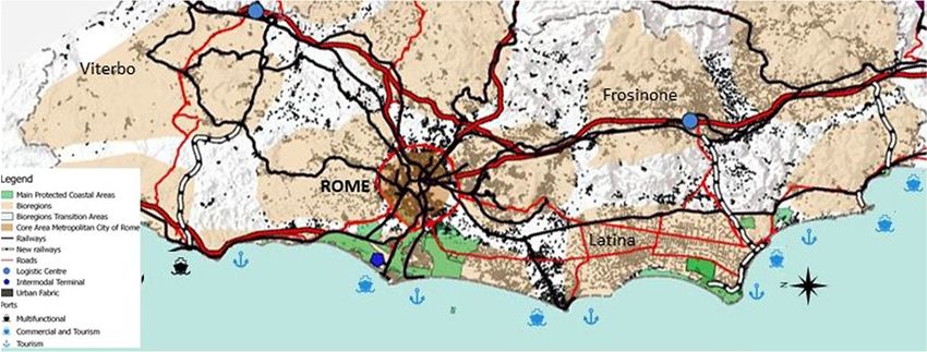
Account taken of the planning framework of Lazio region, the aim of the proposal
presented schematically in Fig. 2 is to relaunch a dialog on the coastal strip and identify the
elements for the integrated approach described earlier.
The coastal strip is defined in terms of: its different bioregions, the need to safeguard the
areas with high rates of biodiversity, and an infrastructural network based on railway links,
particularly those linking the shoreline with the longitudinal main lines. The resulting
networks will create a series of infrastructural corridors that emanate from the integration of
transport planning with territorial planning, and that overcome the decades-long view
whereby such corridors should be limited to assuring mobility between two centres. The latter
view had unfortunately also been adopted by the European Union in the early 1990s, when
the foundations were laid for the development of the Trans-European Transport Network
(TEN): large-scale works to connect the major European centres were, in fact, designed
without taking into account the mobility needs of intermediate local communities.
WIT Transactions on The Built Environment, Vol 188, © 2019 WIT Press
www.witpress.com, ISSN 1743-3509 (on-line)102 Coastal Cities and their Sustainable Future III
Figure 2: A proposal for integrating infrastructural networks and the protection of coastal
areas.
For this reason, this paper defines the word “corridor” as a polysemic term [33], since an
infrastructural corridor is simultaneously:
an infrastructural axis, because it connects different centers located on its path;
an economic development axis, because it allows the movement of people and goods and
can thus favour the location of economic activities;
an urbanization axis, as the supporting structure for urban development and the
redevelopment of adjacent urban fabrics;
finally, if based on railway links, a corridor may also be an environmental redevelopment
axis that helps to overcome the fragmentation caused by road infrastructures while also
guaranteeing a modal shift towards less-polluting means of transport. Although railways
may also cause fragmentation, the latter effect is only physical and affects the
settlements, whereas the fragmentation caused by private automobiles (cars and trucks)
is both physical and, through effects such as urban sprawl, social because private cars
often carry only one person, the driver.
The proposal envisages the reactivation of three East–West railway links – Civitavecchia–
Orte, Terracina–Priverno and Gaeta–Formia – as the structuring principle for reorganizing
the rail networks of Lazio region and part of central Italy.
These links follow the region’s historical three axes of development (northern, central and
southern) mentioned in the Quadro di Assetto Regionale (Regional Development
Framework) of 1977 [34]. Today, their reactivation is necessary not only for the movement
of passengers and goods but also to support repopulation of the internal areas of Lazio region.
The three links would take advantage of parts of disused rail lines that had followed the
natural morphologies of the regional territory.
The reactivated links would support the movement both of goods and passengers, with the
latter service involving the combined use of trains and tram-trains, i.e. using rolling stock
that can travel on different infrastructures and hence reduce the need for passengers to shift
between modes. The three corridors are defined as follows:
the Civitavecchia–Orte link would open a railway corridor for the movement of both
people and goods. With a total length 86 km and crossing 20 municipalities, it would
connect the port of Civitavecchia with the freight hub of Orte, one of the largest in the
WIT Transactions on The Built Environment, Vol 188, © 2019 WIT Press
www.witpress.com, ISSN 1743-3509 (on-line)Coastal Cities and their Sustainable Future III 103
region and a pivot for Central Italy’s freight traffic. A recent PhD thesis recommended
that this railway link be reactivated in order to enhance the rail transport offer and the
repopulation of inner areas [35]. The link would also help implement the Barcelona–
Ploce transverse corridor whose nodal points in Italy would be the ports of Civitavecchia
on the Tyrrhenian Sea and Ortona on the Adriatic Sea [36]. In this corridor the volume
of goods transported by rail is expected to rise from the current 14% to 27% by 2030
[36];
the redeveloped Terracina–Priverno link would be extended by adding a section linking
Priverno Fossanova to the FL6 rail line (Rome–Cassino) at Ceccano station, then
eastwards to the Abruzzo coast. The link may work as follows: from Sabaudia to
Ceccano by tram-train; from Ceccano to Roccasecca on the FL6 Rome–Cassino rail line;
from Roccasecca to Avezzano on the Roccasecca–Avezzano line; and from Avezzano
to Pescara on the Rome–Pescara line. The corridor would thus link the two seas from
Sabaudia and the port of Pescara, passing through the port of Terracina, the hinterlands
of the Pontina Bioregion, Frosinone Province, the Logistic Center of Frosinone and the
Abruzzo region. By doing so, it would strengthen the interregional Lazio–Abruzzo
connection as envisaged by the National Platforms included in the new National
Logistics Plan 2011–2020 [37];
the Gaeta–Formia link would connect these two ports of Lazio region by rail to Cassino
via the FL7 Roma–Minturno railway line. The construction of a rail link between
Cassino and Formia, passing through the Valle dei Santi and providing a second
transversal link between the FL6 and FL7 railway lines, has in fact repeatedly been
promoted by local authorities who highlight the strong social and economic relationships
between Cassino’s industrial zones and Formia’s commercial port. This corridor has
potential for becoming an important axis for the development by strengthening relations
between the western and eastern parts of the Mediterranean. The Balkans, in particular,
have in recent years become one of the most important economic realities in Europe.
According to forecasts released by the Ministry of Infrastructure and Transport regarding
Corridor V of the Ten-T Network, the demand for goods transport along this corridor
may increase by about 44%, from 151 to 267 million tons over 20 years [36].
From the standpoint of feasibility, railway construction requires considerable time in
terms both of design and execution, and this is hampered by a chronic lack of public funding.
A useful instrument for raising part of the financing needed to build the infrastructures is
certainly the application of value-capture tools [38]. Part of the higher real estate property
values accruing to local populations may be captured through appropriate fiscal instruments
to cover part of the costs. For user companies, the enhanced value may be captured by
increasing the fees for chamber of commerce registration by 20% (as done for the
Quadrilatero Marche–Umbria road project currently under construction).
6 CONCLUSIONS
As seen above and notwithstanding rising anthropic pressures, the regulatory and operational
framework for the integrated management of Europe’s coastal areas remains uncertain.
Indeed, European regulations do not support the implementing of effective planning
processes in the areas subject to land-use planning in the various countries.
Methodologically, there is broad agreement with regard to the need to improve planning
processes, but these need to be based on bottom-up processes that involve civil society; in
this sense the bioregion concept provides a useful reference point. In the Italian context,
transport planning can make a major contribution to the coordination task entrusted to it by
WIT Transactions on The Built Environment, Vol 188, © 2019 WIT Press
www.witpress.com, ISSN 1743-3509 (on-line)104 Coastal Cities and their Sustainable Future III
law, during the drafting of PRdSPs and the planning of maritime spaces. The effectiveness
of its contribution will, however, be conditioned by the extent to which it is both integrated
with regional and urban planning and open to a bioregional conception wherein the
construction of visions of the future plays an essential role. There is no denying that the
Universities can play a major role towards that goal in Lazio region.
REFERENCES
[1] European Commission, Office for Official Publications of the European Communities,
European transport policy for 2010: Time to decide. https://ec.europa.eu/transport/
sites/transport/files/themes/strategies/doc/2001_white_paper/lb_texte_complet_en.
pdf. Accessed on: 16 May 2019.
[2] Communication from the Commission to the European Parliament, the Council, the
European Economic and Social Committee and the Committee of the Regions, An
Integrated Maritime Policy for the European Union, Brussels, COM(2007) 575 final,
2007. https://eurlex.europa.eu/LexUriServ/LexUriServ.do?uri=COM:2007:0575:FIN:
EN:PDF. Accessed on: 16 May 2019.
[3] Communication from the Commission to the Council and the European Parliament on
the integrated management of coastal zones COM/95/511 final. https://eur-
lex.europa.eu/LexUriServ/LexUriServ.do?uri=COM:2000:0547:FIN:EN:PDF.
Accessed on: 16 May 2019.
[4] European Commission, Luxembourg: Office for Official Publications of the European
Communities, Towards a European Integrated Coastal Zone Management (ICZM)
Strategy: General Principles and Policy Options, 1999.
http://ec.europa.eu/environment/iczm/pdf/vol1.pdf. Accessed on: 16 May 2019.
[5] Council Recommendation of the European Parliament and of the Council of 30 May
2002 concerning the implementation of Integrated Coastal Zone Management in
Europe (2002/413/EC). https://eur-lex.europa.eu/legal-content/EN/TXT/?uri=CELEX
%3A32002H0413. Accessed on: 16 May 2019.
[6] Directive 2008/56/EC of the European Parliament and of the Council of 17 June 2008
establishing a framework for community action in the field of marine environmental
policy (Marine Strategy Framework Directive). https://eur-lex.europa.eu/legal-
content/EN/TXT/?uri=CELEX%3A32008L0056. Accessed on: 16 May 2019.
[7] Directive 2014/89/EU of the European Parliament and of the Council of 23 July 2014
establishing a framework for maritime spatial planning. https://eur-lex.europa.eu/
legal-content/EN/TXT/?uri=celex%3A32014L0089. Accessed on: 16 May 2019.
[8] Addis, D., Maricchiolo, C., Ndong, C., Petit, S. & Skaricic, Z., La Gestione integrata
delle zone costiere nelle politiche del Mediterraneo e dell’Unione Europea. Reticula
10, pp. 3–9, 2015.
[9] Simpson, B., Motorways of the sea. Detailed Implementation Plan of the European
Coordinator, European Commission – Directorate General for Mobility and Transport.
https://ec.europa.eu/transport/sites/transport/files/101_web_final_ii_mos_dip_2018.
pdf. Accessed on: 16 May 2019.
[10] AIDEnvironment, National Institute for Coastal and Marine Management/
Rijksinstituut voor Kust en Zee (RIKZ), Coastal Zone Management Centre, the
Netherlands, Integrated Marine and Coastal Area Management (IMCAM) approaches
for implementing the Convention on Biological Diversity, Montreal, Canada,
Secretariat of the Convention on Biological Diversity (CBD Technical Series No. 14),
2004. www.cbd.int/doc/publications/cbd-ts-14.pdf. Accessed on: 16 May 2019.
WIT Transactions on The Built Environment, Vol 188, © 2019 WIT Press
www.witpress.com, ISSN 1743-3509 (on-line)Coastal Cities and their Sustainable Future III 105
[11] Saunders, F., Gilek, M., Day, J., Hassler, B., McCann, J. & Smythe T., Examining the
role of integration in marine spatial planning: Towards an analytical framework to
understand challenges in diverse settings. Ocean and Coastal Management, 169, pp.
1–9, 2019.
[12] Janßen, H., Göke, C. & Luttmann, A., Knowledge integration in marine spatial
planning: A practitioners’ view on decision support tools with special focus on
Marxan. Ocean and Coastal Management, 168, pp. 130–138, 2019.
[13] Scaduto, M.L., Il contratto di costa: un trait d’union tra gestione integrata della costa
e pianificazione territoriale? Reticula, 10, pp. 10–16, 2015.
[14] Soja, E.W., Accentuate the regional. International Journal of Urban and Regional
Research, 39(2), pp. 372–381, 2015.
[15] Berg, P. & Darsmann R., Reinhabiting California. Ecologist, 7(10), pp. 399–401, 1977.
[16] Scott Cato, M., The Bioregional Economy. Land, Liberty and the Pursuit of Happiness,
Routledge: London and New York, 2013.
[17] Magnaghi, A., Il progetto della bioregione urbana. Regole statutarie e elementi
costruttivi. La regola e il progetto Un approccio bioregionalista alla pianificazione
territoriale, ed. A. Magnaghi, University Press: Firenze, 2014.
[18] Monceri, F., La classificazione dei porti, Amministrazione In Cammino, 2019.
www.amministrazioneincammino.luiss.it/2019/03/15/la-classificazione-dei-porti/.
Accessed on: 16 May 2019.
[19] Boscolo, E., La gestione integrata delle zone costiere in Italia: Prospettive e prime
esperienze. Rivista Quadrimestrale di diritto dell’ambiente, 1, Giappichielli Editore,
2011.
[20] Cuscito, G., Pechino cerca Roma. Meglio non perdere l’ultimo treno. Limes 2, pp. 83–
89, 2019.
[21] Vv. Aa., 1° Forum Nazionale sulla portualità e la logistica. Lo stato di attuazione del
Piano Nazionale Strategico, Atti del Convegno, Terminal Crociere-Porto di Bari, 2016.
[22] Cascetta, E., Le autostrade del Mare per connettere l’Italia. Il nuovo Marebonus per
una logistica sostenibile, Civitavecchia, 2018
[23] RAM, Una Vision per il Mediterraneo, Report, November 2016.
[24] Commissione presso il Consiglio Superiore dei Lavori Pubblici, Linee guida per la
redazione dei Piani Regolatori di Sistema Portuale, Ministero delle Infrastrutture e dei
Trasporti 2017. https://va.minambiente.it/it-IT/Comunicazione/DettaglioNotizia/
1166. Accessed on: 16 May 2019.
[25] Convenzione per la protezione del Mar Mediterraneo dai rischi dell’inquinamento,
Convenzione di Barcellona del 1995. www.naturaitalia.it/static/temp/allegati_
natura_italia/mare/Convenzione_di_Barcellona_IT.pdf. Accessed on: 16 May 2019.
[26] Council Decision of 4 December 2008 on the signing, on behalf of the European
Community, of the Protocol on Integrated Coastal Zone Management in the
Mediterranean to the Convention for the Protection of the Marine Environment and
the Coastal Region of the Mediterranean (2009/89/EC). https://eur-
lex.europa.eu/legal-content/EN/TXT/?uri=CELEX%3A32009D0089. Accessed on:
16 May 2019.
[27] Romano, B. et al., Modelli di pressione insediativa e di retrofit nel governo del
territorio nelle aree costiere. Reticula, 10, pp. 22–28, 2015.
[28] Legambiente, Abbatti l’abuso. I numeri delle (mancate) demolizioni nei comuni
italiani, Report, 2018.
WIT Transactions on The Built Environment, Vol 188, © 2019 WIT Press
www.witpress.com, ISSN 1743-3509 (on-line)106 Coastal Cities and their Sustainable Future III
[29] Ferrovie dello Stato, Atlante delle ferrovie dismesse, 2017. www.fsnews.it/cms-file/
allegati/fsnews2014/2017_11_10_RFI_Atlante_viaggio_ferrovie_dismesse.pdf.
Accessed on: 2 Apr. 2019.
[30] I sistemi naturali del Lazio, Regione Lazio. www.parchilazio.it/ricerca_aree. Accessed
on: 5 Apr. 2019.
[31] Ministero dell’Ambiente e della Tutela del Territorio e del Mare, Development of a
new one-line model to reproduce the long term beaches evolution in presence of
coastal defence works and its application to define the sediment management of the
coast between Capo d’Anzio and Circeo (Italy) in order to preserve the beaches and
the dunes of the Circeo National Park. Department of Civil, Constructional and
Environmental Engineering, Sapienza University of Rome (research in progress).
[32] Dipartimento di Idraulica, Trasporti e Strade dell’Università di Roma La Sapienza,
Piano di coordinamento dei porti del Lazio, 1998. www.strategiadilisbonalazio.it/
documenti.asp?pagina=3&categoria=1&sottocategoria=11.
[33] Garavaglia, L. & Pennati, D., I corridoi nello scenario territoriale e urbano italiano.
Territorio, 76, pp. 23–27, 2016.
[34] Regione Lazio, Quadro di Riferimento per la programmazione regionale. Studio
Preparatorio, Rapporto Regionale, Roma, 1980.
[35] Sperati, S., Infrastrutture ferroviarie secondarie e rigenerazione del territorio. PhD
thesis, Sapienza University of Rome, 2017.
[36] Di Pretoro, E. & Nervagna, A., Il nuovo corridoio mediterraneo, Edizioni Menabò,
2016.
[37] Ministero delle Infrastrutture e di Trasporti, Piano Nazionale della Logistica 2011–
2020, Rome, 2010.
[38] Sumiraschi, C., Catturare il valore. Politiche innovative per finanziare le
infrastrutture, Egea: Milano, 2013.
WIT Transactions on The Built Environment, Vol 188, © 2019 WIT Press
www.witpress.com, ISSN 1743-3509 (on-line)You can also read