URBAN PLANNING IN RIO DE JANEIRO: A CRITICAL REVIEW OF THE URBAN DESIGN PRACTICE IN THE TWENTIETH CENTURY
←
→
Page content transcription
If your browser does not render page correctly, please read the page content below
Copyright © 2006 by the author(s). Published here under license by CECI.
The following is the established format for referencing this article:

Brandão Z. 2006, Urban Planning in Rio de Janeiro: a Critical Review of the Urban Design Practice in the Twentieth
Century. City & Time 2 (2): 4. [online] URL: http://www.ct.ceci-br.org

URBAN PLANNING IN RIO DE JANEIRO: A CRITICAL REVIEW OF
THE URBAN DESIGN PRACTICE IN THE TWENTIETH CENTURY

Zeca Brandão

              Abstract

              This paper is an outcome of a research entitled “The Role of Urban Design in
              Strategic Planning: The Case of Rio de Janeiro”, which was carried out at the
              Architectural Association Graduate School, in London.

              This paper presents a historical review of the urban development of Rio de
              Janeiro, Brazil. The study gives an overview of the city’s urban planning
              through time, pointing out some connections between the different urban
              factors involved in the urbanization process. By focusing on the project scale, it
              intends to show the roles that urban design have played during the different
              periods of the urban planning in Rio de Janeiro. The general argument of the
              paper is that since the turn of the twentieth century, the city has played an
              important role as a laboratory implementing and adapting established
              international urban concepts to the local reality. Although such a position has
              been lost during the 1970s and 1980s, this study shows that the tide began to
              turn in the 1990s and the revival of urban design has emerged as one of the
              main features of the current urban policy in Rio de Janeiro.

              Key words: Rio de Janeiro, urban planning, urban renew, XX Century

The Great Urban Reforms in Rio: First Half of the Twentieth Century

Under the administration of the engineer Francisco Pereira Passos, Mayor of Rio de
Janeiro from 1902 to 1906, the city initiated the era of great urban renewal. The core of the
city went through a period of intensive construction work, which destroyed the last
vestiges of its colonial urban design.
The redesign of Central Rio aimed, above all, to provide the city with an urban space that
could express its increasing importance on the international scene. This new desirable
image of Rio was not in agreement with the colonial appearance of its central area, where
the headquarters of political buildings were mixed with poor slum houses. In order to
elevate the new Rio de Janeiro to the same level of other important international cities, a
radical urban transformation took place.
With the political motivation for rebuilding dirty cramped alleys formed by precarious
airless dwellings in order to eliminate epidemic diseases, Central Rio was modelled on
monumental splendour perceived as characteristic of the great European capital cities. A
powerful urban reconstruction process took place inspired by the Paris of the Second
Empire and grand avenues ending in impressive urban squares surrounded by public
buildings were all built to embellish the city.

                                                                                                                37
During the same period, some large scale urban interventions funded by the Federal
Government, also took place in Rio. Although relatively few in number, they caused
much more urban impact than the Pereira Passos projects, due to their vast scale. The
most impressive one, taking into consideration the morphological transformation of the
city’s urban fabric, was the opening of the Central Avenue (Avenida Central).

Fig. 01: The opening of the Avenida Central and the impact on the city’s urban fabric

Based on the Parisian boulevards designed by Haussman, thousands of colonial buildings
were demolished in order to open out the Central Avenue. This avenue, today renamed
Rio Branco Avenue (Avenida Rio Branco), must have once been Latin America’s most
impressive urban highway. Bordered by buildings of no more than three storeys high and
with a promenade that ran right down the centre, this avenue became the heart of the
nightlife of the city. Nowadays, even though it is still one of the most important streets of
Rio, the once graceful avenue with its glamorous restaurants, theatres and cafés, has been
swamped by inexpressive office buildings and traffic pollution.

Fig. 02 / Fig. 03: The glamorous Avenida Central during the first half of the twentieth century

Where the Central Avenue crosses the Seafront Avenue, which was also built at this time,
there is the Marechal Floriano Square (Praça Marechal Floriano) and the area known
today as Cinelândia, named after long-gone cinemas built in the 1930s. Designed to be the
cultural core of the city, this section of Rio Branco Avenue is the only part of the scheme
that remains impressive. It is surrounded by interesting public buildings such as the
National Library (Biblioteca Nacional), the Municipal TheatreTP1PT (Teatro Municipal), at
the northern end of the square and the Fine Arts National GalleryTP2PT (Museu Nacional

1PT
TP   The Municipal Theatre is clearly inspired on the Paris Opera House and has been Brazil’s most prestigious
artistic venue since it was opened in 1909.
TP2PT The Fine Arts National Gallery, built in 1908, is another public building whose design was based on a
French Architectural Icon: the Louvre Museum in Paris.

                                                                                                           38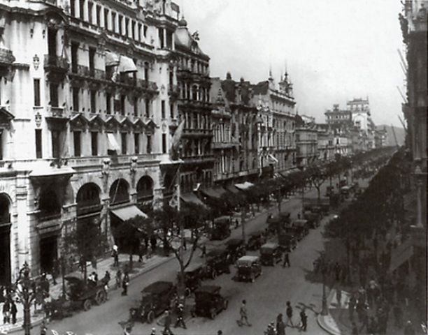
de Belas Artes), on the opposite side of the road. This urban area is probably the best
example of the “Belle Epoque” style in Rio.
The Pereira Passos Administration brought about significant improvements, in terms of
infrastructure and appearance to the central area of the city. On the other hand, through
the opening and widening of streets and avenues a great number of poor colonial houses,
where the low-income communities used to live, were demolished. Nearly three thousand
such dwellings were razed to the ground during his administration (FINEP, 1985). As this
urban renewal programme had built very few alternative social housing schemes, most of
those people, although needing to remain close to their places of work, could not afford to
live in the area any longer.
The solution found by the people was the beginning of one of the greatest contemporary
urban problems of Rio de Janeiro. The widespread tenement demolition led the evicted
population to build their own houses in the vacant surrounding areas. The homeless
quickly occupied the previously deserted main hills located in the city centre in a very
precarious way, giving rise to the first shantytowns which are known in Rio as favelas.
The Pereira Passos Reform represented the first example of massive urban intervention
sponsored by the public sector in Brazil. Up to that time, the role of the State concerning
urban development was restricted to controlling private sector initiatives. This new way
of planning the city established by the Passos Reform totally changed the urban
development pattern throughout the twentieth century. Apart from the period of time
between 1914 and 1918, when a policy for restraining public expense was implemented in
the whole country due to the First World War, the following elected Mayors tried to
maintain the same aggressive style of planning (Reis, 1977).
The Carlos Sampaio AdministrationTP3PT for instance, had as its main goal the
preparation of Rio de Janeiro for the coming celebration of the first Centenary of Brazil’s
Independence. A great number of national and international tourists were expected to
take part in the Festival, which would be highlighted by an International Exhibition. As
the site for this event had not been decided when Sampaio was nominated, he saw it as an
opportunity to provide continuity to the redesigning of Central Rio that had been started
by Pereira Passos (Reis, 1977 and Abreu, 1997).
Eager to provide the perfect site for the International Exhibition, he carried out the
demolishing of the historical Castle Hill (Morro do Castelo) and removed one of the city’s
earliest and poorest neighbourhoods called Misericordia, which was located on the base
of that hill (Abreu, 1997). Those areas, although still occupied by low-income people, had
become one of the most expensive parts of the city after the inauguration of the Central
Avenue.

3 Carlos Sampaio was the Mayor of Rio de Janeiro from 1920 to 1922 and he contributed a great deal in
transforming Central Rio. Even though he did not implement as many urban works as Pereira Passos.

                                                                                                        39
Fig. 04 / Fig. 05: The demolition of the historical Morro do Castelo

With the demolition of the Castle Hill and the Misericordia District, two more working
class communities, which had hardly survived the Pereira Passos Reform, were expelled
and a large empty site became available, exactly in the heart of Central Rio. This site with
a nearby landfill area, which resulted from the removal of the hill, not only resolved the
problem concerning the location of the International Exhibition, but also provided an
excellent opportunity for new urban developments.
Another Mayor, who played an important role in the urban planning development of Rio
de Janeiro, was Antônio Prado Junior. During his Administration, in the late 1920s, a
French urban planning team headed by Alfred Agache, who was a member of the English
originated Gardens-City Movement, was commissioned to design a plan for the city. The
Agache Plan had the general intention to beautify Rio, especially the central area and its
southern districts, and to organise the city according to specific activities. Central Rio, for
instance, would be functionally divided into six distinct sectors: Business Centre (Centro
de Negócios), Administrative Centre (Centro Administrativo), Monumental Centre
(Centro Monumental), Financial Centre (Centro Bancário), Embassy District (Bairro das
Embaixadas) and Calabouco Gardens (Jardins do Calabouço) (Reis, 1977).
As far as residential areas were concerned, Agache had physically formalised the latent
socio-economic stratification present in the city. The new and still dispersed southern
districts located on the seacoast, such as Copacabana, Ipanema and Leblon, were designed
similar to European Garden Cities, aiming to attract the affluent class of Rio. For the early
districts of the city, such as Catete, Botafogo, Flamengo, Laranjeiras,Vila Isabel and Tijuca,
the plan had suggested a less radical design, following the already consolidated urban
fabric, to house middle-class communities. For the poor people, the plan had intended to
prepare the suburban areas of the city by building social housing schemes, improving
basic infrastructure and providing a good public transportation system.
The Agache Plan was over ambitious and the Municipal Administration had neither time
nor financial resources to implement it completely. Even so, this plan has been considered
a turning point in the urban planning process of Rio de Janeiro. For the first time the
Municipality seemed to admit that it was losing control over Rio’s urban growth and was
prepared to commission an international planning team to design an overall plan for the
whole city.
Nevertheless, some urban interventions proposed by the Agache Plan, such as the
opening of the Presidente Getulio Vargas Avenue (Avenida Presidente Vargas), were
carried out in the following decades. The plan had suggested the construction of a huge
avenue that would work as a sort of urban expansion axis perpendicular to the Central
Avenue. In order to do that, it was necessary to demolish every block located between the

                                                                                             40
General Câmara and São Pedro streets, from the well-known Eleventh Square (Praça
Onze) to the charming Candelaria Church (Igreja da Candelária). The square itself and
more than five hundred buildings were destroyed due to this urban reform (Reis, 1977).
Many authors have considered this intervention one of the greatest mistakes of urban
planning in Rio. Besides the demolition of a significant historical area of the city, the
project aggravated the deterioration process by splitting the surrounding urban fabric.
Apart from a small sector near the crossroad with Central Avenue, the urban
development expected for the side of this avenue never happened and the monumental
buildings planned remained on the drawing boards.
Fig. 06 / Fig. 07: The opening of the Av. Presidente Vargas splitting the urban fabric
In 1929, while the Agache Plan was still being conceived, Le Corbusier was visiting Rio
and took the opportunity to make sketches of some urban ideas for the city. His proposals
showed some essential differences in terms of city images, and two conflicting urban
design models based on divergent theoretical movements appeared. While Agache’s
master plan seemed to be more concerned about the empty spaces defined by the
buildings rather than the buildings themselves, Corbusier’s controversial suggestions
emphasised the architectural object.
Fig. 08: One of the Corbusier’s urban proposals for Rio: a massive and tortuous residential building topped by
a sort of highway roof.
Although Corbusier’s proposal was never built, its design principles guided most of the
urban and architectural projects implemented in Rio, from the 1930s to the 1960s. Modern
Architecture was established and became a sort of consensus among designers.
Rio was transformed into a huge construction site with both private and public
developments emerging all over the city. Growth was so fast that planning was left
behind. The city’s population increased from nearly 1.8 million inhabitants in 1940 to 2.4
million in 1950 and reached 3.3 million in 1960, while the Greater Rio, constituted by the
metropolitan areas of the city, expanded from 2.2 million people to 4.9 million during the
same period (IBGE, 1966).
By that time, the city had started to show the first signs of an uncontrolled urban dynamic
growth. While central areas of the city were facing physical deterioration due to the
ongoing spontaneous removal of the population, the suburban districts were going
41through an unrestrained urban expansion. Reasonably well provided areas, in terms of
infrastructure, were being abandoned by people while other parts of the city, which
lacked basic services, were being occupied by them.
The Impact of the National Automotive Industry on Urban Design Policies in
Rio
At the beginning of the 1960s, another extensive urban change took place in all
metropolitan cities of the country. The national automotive industry was born and streets
of most cities became crowded with cars. The geographical location of the city, squeezed
between the mountain slopes and the sea, escalated the problems and Rio found itself
particularly exposed, with traffic becoming chaotic. This fact affected Rio’s citizens by
forcing them not only to deal with huge and frequent traffic jams, but also to share the
sidewalks of the city with cars that used them as parking places.
The fast growth in car traffic led the city to an unprecedented open conflict between the
new type of transportation and the town fabric. Parts of the city that had emerged mostly
for the priority of pedestrians had to be adapted to massive car traffic. In order to refit
these areas for new car demands, urban planning policies in Rio had their main focus
changed and gradually traffic engineers took over the lead of urban design teams.
Tunnels, overpasses, bridges and both ground level and elevated highways became the
principal components of urban design.
In the late fifties a Greek urban planning company named Doxiadis and Associates was
commissioned to design a new plan for the city. Similar to the Agache Plan in the 1920s,
the Doxiadis Plan was heavily based upon interventions on consolidated urban
infrastructure. However, the current focus was the accessibility and mobility provided to
the car and the plan proposed a new high-speed traffic circulation network for the city.
The Doxiadis Plan left, as its main legacy, a wide range of highways coded by colour lines
such as Red Road (Linha Vermelha) and Yellow Road (Linha Amarela) that were
eventually built in the 1990s.
Public urban interventions in Rio became almost totally reduced to road constructions
during the 1960s and the 1970s. An endless list of urban works could be made showing
improvements in car transportation that were carried out during those times. Many
important tunnels, such as Rebouças and Santa Bárbara were dug in order to connect
areas of the city that used to be separated by mountains. Some elevated highways, such as
Paulo de Frontin and the Perimentral were also built to complement the already saturated
ground level avenues. Not to mention the impressive 14 kilometre bridge named the
Costa e Silva Bridge4.
Although most urban interventions at that time had the exclusive purpose of improving
car traffic, some of them tried to take into account the pedestrian as well. Two landfall
areas could be mentioned as good examples of urban projects where attempts to achieve a
fair balance between the pedestrian and the automobile were made, even though the main
objective in both cases was to relieve traffic congestion. They were the Flamengo
ParkPTP5PT (Aterro do Flamengo), built from 1961 to 1965 and designed by the urban
architect Affonso Eduardo Reidy and the landscape architect Roberto Burle Marx, and the
4 This bridge, popularly known as the Rio-Niteroi Bridge, links the two largest cities of the region by crossing
the Guanabara Bay.
5 Repeating the same strategy applied in the 1920’s, another historic hill named Morro de Santo Antônio was
demolished in order to carry out the landfall Aterro do Flamengo.
42Copacabana Beach Sidewalks (Calçadão de Copacabana), which was built from 1969 to
1972 and also designed by Burle Marx.
Fig. 09: Aterro do Flamengo (1961/1965) Fig. 10: Calçadão de Copacabana (1969/1972)
Nevertheless, the widespread shift of urban design policy in Rio towards prioritisation of
car traffic and parking had gradually taken streets and squares from the pedestrian. The
result was that walking around and spending time in public spaces became unpleasant
and a steady impoverishment of city life took place. The obvious correlation between
public space and social life is very well illustrated in the case of Rio. The city once
internationally known for its social life, promoted by a broad spectrum of outdoor
activities, had dramatically changed.
The deterioration of public spaces in Rio led to the development of private clubs,
shopping malls and condominiums confined in enclosures. The hostility pedestrians
experienced in public spaces encouraged them to bypass these areas on the journey from
home to work. The established role of public spaces as the most important meeting places
in Rio began to change and people started to use the growing number of private locations
for socialising.
This architectural privatisation of the physical public sphere, which has increasingly
happened all over the world, has been even worse in cities like Rio, where a considerable
number of inhabitants live an extremely difficult life below the poverty line. The
enormous economic gap between the rich and the poor existing in large developing cities
has transformed the public realm into unsafe urban spaces of high social tension.
Under these conditions, the possibility of having a safe indoor “public” life heavily
patrolled and regulated by security guards became a very attractive proposition to
middle-class citizens. The expansion of this “architectural urbanism” in Rio, progressively
confining the city inside its walls, demonstrates its increasing public desirability. For
some citizens, who take the inevitable consequences of such an attitude to the extreme,
the city has become a proliferation of isolated indoor “urban spaces” connected by wide
highways.
43The transference of the country’s capital to the newly built Brasilia in 1960 could be also
considered an important factor in exacerbating Rio’s environmental deterioration. By
losing the status as the Capital of Brazil, the city also lost a great deal of its economic and
political power. The focus of the urban policy on overpasses and highways established in
the 1960s and 1970s, besides aiming to better the car traffic flow in the city, it seems to
have been a desperate attempt to maintain the status of Rio. After all, Brasilia with
freeways and viaducts everywhere suggesting modernity and power was designed to
replace Rio as the head of the country (Holston, 1993).
In 1969 this new pattern of life was instigated in Lucio Costa’s master plan for the Baixada
de Jacarepagua. For the first time, a whole district of Rio de Janeiro was designed
following the road-oriented modernist principles6P In a way, it was the last urban attempt
to show that Rio, as well as Brasília, had also achieved absolute modernity. Nothing
appeared to be more appropriate, at that time, than having a large part of the city
designed by the same urban architect following the same urban paradigm. The idea was
to plan a new district that, by overcoming the chaos of the traditional city, would provide
a perfect urban environment for modern living (Costa, 1969).
Aiming to avoid the problems of the old urban areas of the city, the plan represented a
complete breakdown of the traditional urban pattern in terms of zoning use and division
of land. It was basically constituted by urban nuclei with residential towers connected by
narrow streets and small squares surrounded by shops. Huge green areas without any
precise proposed activities separated these nuclei from one another. As the minimum
distance between the nuclei was 1 kilometre, a massive freeway system was designed to
link them.
Although the intention of the plan was to provide a comfortable and socially integrated
urban space whereby car traffic could coexist peacefully alongside other uses of the city
(Costa, 1969), the outcome was tragic. Boundary walls have surrounded the urban areas
and “public” spaces, except for the beach, have become walled in private condominiums
and shopping malls. Ironically, this district of Rio, which was designed aiming to bring
social integration back into public domain, became the most segregated urban space in the
city.
Regulatory Master Plans: The Case of Urban Structural Projects
During the 1970s and 1980s, the city of Rio de Janeiro was ruled by massive rational plans,
which were full of institutional analyses supported by a huge amount of quantitative data
with questionable pragmatic applicability. The plans were largely regulatory, focusing on
what should be avoided rather than presenting clear urban proposals. They were very
ambitious in scale and based upon long-term anticipatory actions, which very often made
them ineffective at dealing with current needs.
The Basic Urban Development Plan (Plano Urbanístico Básico-PUB) implemented in 1977,
although it can be included in the above description, must be mentioned as an important
attempt at providing tangible outcomes (Del Rio, Santos and Fontes, 1986). By creating the
Urban Structural Projects (Projetos de Estruturação Urbana-PEUs), this plan provided a
crucial tool for resolving the lack of objectivity in planning at that time and paved the way
for the development of concrete urban actions.
6Up to this time the new districts developed in the twentieth century, such as Copacabana, Ipanema and
Leblon, were an interesting mix between traditional and modern urbanity.
44The original concept of PEU was to give particular attention to homogenised urban
sections by implementing special urban projects, which would prevail over the zoning
regulation of the whole area. Through designing street and square patterns, defining uses
and activities and having as a final outcome a mass plan, the PEUs brought back to the
planning scale the possibility of developing urban design projects. However, this wide
and integrated approach was never achieved and it became, in practical terms, a building
regulation review project (Del Rio, 1990).
During that time, a building boom was creating deep transformations of the townscape
and several important symbols of the city were being threatened by such uncontrolled
urban development. This environmental problem paved the way for citizens’ resistance,
which grew based on a strong sense of identity. Local people started to organise
themselves in order to fight for preservation and better living conditions in their
residential districts (Santos, 1988). In that context, the PEU project was promptly seen as
an opportunity to establish special urban regulations to cope with citizens’ demands
(IBAM, 1994).
Many PEU projects were carried out all over the city during that time and most of them
due to claims raised by what came to be known as the social movements, especially
concerned with historic and ecological preservation (Del Rio, Santos and Fontes, 1986).
Until that time, traditional planning in Rio had very often neglected built and natural
environments. By engaging local people, the PEU projects played an important role in
bringing environmental issues onto urban policy agendas. Subsequently, community
participation, which was one of the most significant features of many urban projects, has
become an indispensable practice adopted in urban planning in Rio.
The urban conservationist movement, for instance, had its first proposal accepted by the
Urca Urban Structural Project (PEU-Urca). Designed and implemented in 1978, by the
Municipal Planning Department, this PEU was the first one to be conceived and arose in
response to demands from the local population to protect the district against speculative
construction processes that were taking place at that time (Del Rio, 1990).
The small and wealthy district of Urca is located in a very special part of the city, where
the Guanabara Bay meets the Atlantic Ocean, and it already had some environmentally
protected areas, even before the project was implemented. However, those environmental
regulations had, as their main goal, to preserve the Sugar Loaf Mountain, which is located
in the district and is one of the most important landmarks of Rio. Thus, it was entirely
restricted to the mountain itself and surroundings. By establishing the limits for the height
of new buildings and keeping the density under severe control in the whole district, the
PEU-Urca succeeded in preserving the neighbourhood’s identity.
Numerous other important PEU projects were implemented in different districts of the
city, like the PEUs Botafogo (1983) and Santa Teresa (1985). Nevertheless, the most
prominent conservationist urban project was undoubtedly the Cultural Corridor Project
(Projeto Corredor Cultural). Based upon the work carried out by urban architect Augusto
Ivan in 1979, this project became a broad preservation programme for central Rio. For the
first time, a historic preservation project was concerned with protecting the urban
environment as a whole, rather than focusing on the architectural value of an individual
building (Carvalho, 1983) TP7PTP The recognition that the environmental quality of a
particular urban space is not exclusively due to the quality of its buildings was a
paradigmatic changing of urban planning in Rio.
7Until that time, national and local preservation policies were based on a narrow-minded view that only
important buildings, with conceived architectural merits, should be preserved.
45Initially implemented in one of the most traditional streets of the city, named Carioca
Street (Rua da Carioca), the Cultural Corridor Project has been extended throughout
central Rio (Pinheiro, 1985). After many decades of continual deterioration, the inner city
has been entirely transformed through a broad concept of revitalisation, which included
economic, physical, social and, above all, cultural recovery of the area (Carvalho, 1983).
The project, which has become a model of urban preservation in Brazil, recovered the
symbolic meaning of this part of Rio, by giving back its cultural role that was built up
over the centuries. A notable part of the city centre has, nowadays, an atmosphere that
invites people to spend time there and it would not be an overstatement to say that central
Rio has been one of the most attractive options for passing leisure time in the city for the
last decade.
During the 1980s, however, urban planning in Rio must be understood in the context of
the economic recession and political re-democratisation, which the country was going
through by that time. If, on one hand, very few public and private developments occurred
in that decade, due the stagnation of the Brazilian economy, on the other hand, the return
of political freedom, after twenty years under a dictatorial regime, emphasised the
importance of the social movements in the construction of the cityTP8PT.
The Brazilian civil society slowly started to be reorganised and free elections were held for
state governors and members of the congress. The desperate attempt made by
democratically elected governments in responding to the proliferation of social demands
from different organised groups formed the basis of urban planning in all the large cities
of the country (Santos, 1988). Nevertheless, as it was mentioned above, this period of
transition towards democracy took place during a severe economic recession and scarcity
of resources marked the urban developments in the 1980s.
Contemporary Urban Planning in Rio: Redeeming Urban Design
The deterioration of Rio de Janeiro escalated into the 1990s due to impoverishment of its
population, dilapidation of public services and, above all, the disorderly use of both
public and private urban spaces. As a result of many years of urban policy neglecting the
quality of the city’s public realm, not only in its social dimension but also in its physical
spatiality, Rio started the decade with the highest street crime rates of its history. The
city’s image changed from once nationally and internationally known as the “wonderful
city” (Cidade Maravilhosa), and became a city associated with urban violence and
insecurity.
In terms of planning ideology, a substantial change took place with a growing disbelief in
the effectiveness of large-scale ambitious plans. Those plans, which had been
implemented in the city since the 1970s, were heavily criticised for their lack of practical
results. Apart from the Urban Structural Project (PEU) already mentioned, very few
projects were effectively implemented as by-products of those plans. The revitalisation of
the urban project and the consequent revival of design as the main tool for city planning,
have gradually been consolidated through Rio’s official urban policies.
The 1992 Summit Conference on Sustainable Development of the Earth - Eco 92, a global
environment forum promoted by the United Nations and held in Rio, was the turning
point towards a new urban approach for the city. Taking advantage of the international
repercussions surrounding the event, the local government focused its efforts in rescuing
8Three of these social movements played a distinguished role in restructuring urban planning in Rio, which
were the neighbourhood-association, heritage-preservation and ecological-environmental movements.
46Rio’s public spaces. Some very simple and inexpensive urban programmes, which have
produced significant social gains for the city, were implemented.
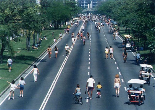
One of the most interesting was to close some streets, avenues and even freeways from
the motorised traffic during Sundays and Bank Holidays. By transforming roads into
temporary pedestrian meeting places, this urban programme has created alternative
public spaces all over the city.
It included the coastal avenues of wealthy districts, such as Leblon, Ipanema and
Copacabana, and the less privileged areas, where the need for public spaces was widely
recognised. Not to mention the immense Flamengo Landfill (Aterro do Flamengo), which
has attracted crowds from diverse surrounding districts for walking, running, biking,
skating, or simply socialising. These new car-free public spaces have been used for
recreational activities, in which the opportunity to see, meet and interact with other
people has become a significant attraction.
Fig. 11: The Aterro do Flamengo closed to cars during Sundays and Bank Holidays
More permanent urban interventions for the improvement of the city’s public spaces were
also developed, such as the Rio Coast Line Project (Projeto Rio Orla). Implemented
between 1992 and 1993, this project aimed to reinforce the vocational role of Rio’s beaches
as social integrators. Leblon, Ipanema and Copacabana, which are the three most well
known beaches of the city, had their landscape transformed. Through the redesign of the
sidewalks, clearly prioritising pedestrian activities over car traffic and parking, the
scheme provided new standardised kiosks and bicycle paths linking the beaches.
With a special lighting system designed to optimally illuminate the roads, sidewalks and
beaches, the project encouraged the practice of a variety of nightly recreational activities.
The development of Rio Coast Line made activities, such as fishing, swimming, jogging
and many other sport practices which, previously for security reasons, had only taken
place on the beaches during the day, very popular evening activities.
Nevertheless, even though the Rio Coast Line Project has succeeded in promoting social
life by improving public spaces, it was a controversial initiative that gave rise to an
extensive public debate. Besides technical criticism regarding specific design features, the
project was heavily criticised for being restricted to a very small and already privileged
part of the city. Whilst accepting the criticism in relation to the elitist nature of the scheme,
the City Hall developed the Rio City Programme (Projeto Rio Cidade).
Created in 1993 and based on a number of theoretical points raised by Janes Jacobs,
Gordon Cullen, Kevin Lynch and others, who had already stressed in the 1960s the social
importance of streets for the development of citizenship, the Rio Cidade Programme was
47a plan for the reconstruction of the public spaces. It basically proposed the redesign of
Rio’s main roads and their surrounding squares in order to regulate their usage and
improve urban standards. Although its physical target was limited to streets and squares,
the ultimate goal was to restore, through the improvement of those public spaces, the
depleted social life of the city (IplanRio, 1996).
According to Luiz Paulo Conde9, the programme was conceived with a commitment to
making it feasible, bearing in mind the failure of the over ambitious plans from the mid
1960s to late 1970s. As was said above, the urban plans developed in Rio during that time
were usually based upon abstractions without an accurate sense of social, economic or
political feasibility and therefore of little practical use. Instead, this urban programme
intended to establish an official compromise in order to avoid idealistic and unattainable
objectives, by setting up well-balanced goals between desirable and achievable scenarios
(IplanRio, 1996).
Fig. 12: The Rio Cidade Ipanema, designed by the architect Paulo Casé, was one of the most polemic urban
projects generated by Rio Cidade Programme
The Rio Cidade Programme has been the greatest urban intervention in Rio de Janeiro,
since the massive landfills and tunnels engineered in the 1960s. The difference was that
instead of focussing attention on cars, the design projects generated by the programme
have privileged pedestrians. Putting to one side the ambitious goal of building the ideal
city, the programme has opted for upgrading the existing one by reorganising the public
spaces. By doing that, it has improved functional and aesthetical qualities of those urban
spaces, contributing to reduce the social pressure in some of the most complex areas of the
city.
Final Considerations: the Reconciliation of an old Marriage between Rio de
Janeiro and Urbanism
Far from being conclusive, this paper aimed only to give an overview of the planning
process in Rio during the twentieth century, pointing out some connections between the
different urban factors involved. As observed, the city of Rio de Janeiro has had its urban
development based around several plans, programmes and projects. Even though many
of the ideas proposed by them have not been implemented, they all were relevant for the
development of the city.
9Luiz Paulo Conde is a well known Brazilian architect who was the head of the Municipal Urbanism
Department when the Rio Cidade Programme was implemented.
48Ever since the turn of the twentieth century, when urban planning became a professional
discipline in Brazil, the city of Rio de Janeiro has played a crucial role as a laboratory,
implementing and adapting established international urban concepts to the local reality.
Right up until the end of the 1960s, urban issues had been subjects of ample public debate
with the average citizen showing interest and awareness on city planning, probably more
than any other city in the country.
However, during the 1970s and 1980s Rio lived through a period of uncertainty
concerning urban policy, leading the city into an urban crisis whose consequences are
manifested through the deterioration of its urban spaces. Several successive
administrations neglected the city’s public life, not only in its social aspect but also in its
physical and spatial dimension. The usually keen and critical attitude of the city’s
population towards urban issues, acquired through decades of practice, have dramatically
diminished, taking with them a great deal of information about planning.
Throughout this period, the Municipality gradually lost control over the city’s planning
process and a growing urban disorder began to take hold. As has been shown in this
paper, the city of Rio de Janeiro entered the 1990s immersed in a decadent, social,
economic and physical context. Rio’s image as one of the most interesting cities in the
world was jeopardised by the remarkable level of urban violence, making people afraid of
walking along its streets.
During those two decades urban policies in Rio were based upon static and generic urban
plans, which were partially implemented through over-ambitious public works quite
often left unfinished. Another characteristic of those plans was that they were clearly
dominated by disciplines, such as Sociology and Economy among others, which, although
relevant, considered only partial views of the city. Urbanism as an autonomous discipline
that emphasises design, city image and urban culture, in which a range of distinct fields is
considered, simply disappeared. Urban projects, once the foundation of planning in Rio,
became sub-products of the whole planning process and urban design, which used to be
its main tool, was transformed into a complementary, perhaps neglected, activity.
The general loss of faith in physical planning, not only in Rio but all over the world, led
social scientists to become the protagonists of urban planning. Although social science has
indeed provided interesting and efficient methods for diagnosing urban problems, it does
not seem to offer suitable tools for solving them. The design-based approach, on the other
hand, over the centuries has developed problem-solving skills which make it much more
capable of generating solutions. The decline of urban design in the planning process was
particularly depressing in the case of Rio de Janeiro, whose physical development had
been based largely on a series of successful urban projects.
However, this study showed that the tide began to turn at the beginning of the 1990s. The
return to the public debate of issues concerning urban aspects brought a long period of
Rio’s citizen apathy to an end. Public space and public life were reintroduced into Rio’s
urban policy and the public image was rescued through the redesigning of several streets
and squares, all over the city. A renewed urban policy based upon design projects was
established and a great number of public spaces have been renovated over the last ten
years. The revival of urban design, as the main tool for the renovation of public spaces,
has emerged as one of the principal features of the current urban policy in Rio de Janeiro.
Bibliography
Abreu, M. (1997). Evolução Urbana do Rio de Janeiro. IplanRio, Rio de Janeiro, (first
published 1987).
49Carvalho, M. (1983). O Corredor Cultural. Revista Módulo, No 77, Rio de Janeiro.
Costa, L. (1969). Plano-Piloto para a Urbanização da Barra da Tijuca. Governo do Estado
da Guanabara, Rio de Janeiro.
Del Rio, V.; Santos, L., & Fontes, L. (1986). Os Projetos de Estruturação Urbana no
Processo de Planejamento. Revista Projeto, No 96, São Paulo.
Del Rio, V. (1990). Introdução ao Desenho Urbano no Processo de Planejamento. PINI
Editora, São Paulo.
FINEP. (1985). Habitação Popular: Inventário da Ação Governamental. FINEP, Rio de
Janeiro.
Holston, J. (1993). A Cidade Modernista: uma Crítica de Brasília e sua Utopia. Companhia
das Letras, São Paulo, (first published 1989).
IBGE (Instituto Brasileiro de Geografia e Estatística) (1966). Características Demográficas e
Sociais do Estado da Guanabara. IBGE, Rio de Janeiro.
IBAM (Instituto Brasileiro de Administração Municipal) (1994). Projetos de Estruturação
Urbana da Cidade do Rio de Janeiro, IBAM, Rio de Janeiro.
IplanRio (Empresa Municipal de Informática e Planejamento S.A.) (1996). Rio Cidade: o
Urbanismo de Volta as Ruas. Mauad, Rio de Janeiro.
Pinheiro, A. I. (1985). Corredor Cultural, Um Projeto de Preservação para o Centro do Rio
de Janeiro. PMRJ, Rio de Janeiro.
Reis, J. (1977). O Rio de Janeiro e seus Prefeitos: Evolução Urbanística da Cidade. PMRJ,
Rio de Janeiro.
Santos, C. (1988). A Cidade como um Jogo de Cartas. Editora UFF, Niteroi.
50You can also read