BUILDING HEIGHTS SURVEY CORK - FORMER FORD DISTRIBUTION SITE STRATEGIC HOUSING DEVELOPMENT JUNE 2020 - The South Docks SHD
←
→
Page content transcription
If your browser does not render page correctly, please read the page content below
BUILDING HEIGHTS
SURVEY CORK

FORMER FORD
DISTRIBUTION SITE
STRATEGIC HOUSING
DEVELOPMENT
JUNE 2020
4255

                                  REPORT PRESENTED BY    URBAN INITIATIVES STUDIO LTD

                                  IN ASSOCIATION WITH    MARINA QUARTER LIMITED

                                  STATUS                 REPORT

                                  ISSUE NO.              02

                                  DATE ISSUED

                                  FILE NAME              4255_20200706_Ford Site_Height Survey_ROC.indd

                                  PROJECT DIRECTOR       Matthias Wunderlich

                                  REVIEWED BY            Hugo Nowell
                                  DESIGN DIRECTOR

                                  APPROVED BY
                                  DESIGN DIRECTOR

                                  This document has been prepared for the exclusive use of the commissioning party and unless otherwise
                                  agreed in writing by Urban Initiatives Studio Limited, no other party may copy, reproduce, distribute, make
                                  use of, or rely on its contents. No liability is accepted by Urban Initiatives Studio Limited for any use of this
                                  document, other than for the purposes for which it was originally prepared and provided.
                                  Opinions and information provided in this document are on the basis of Urban Initiatives Studio Limited
Exmouth House, 3-11 Pine Street
                                  using due skill, care and diligence in the preparation of the same and no explicit warranty is provided as
London EC1R 0JH
                                  to their accuracy. It should be noted and is expressly stated that no independent verification of any of the
                                  documents or information supplied to Urban Initiatives Studio Limited has been made.
+44 (0)20 3567 0715
www.uistudio.co.uk                Urban Initiatives Studio Limited. Registered in England No. 8236922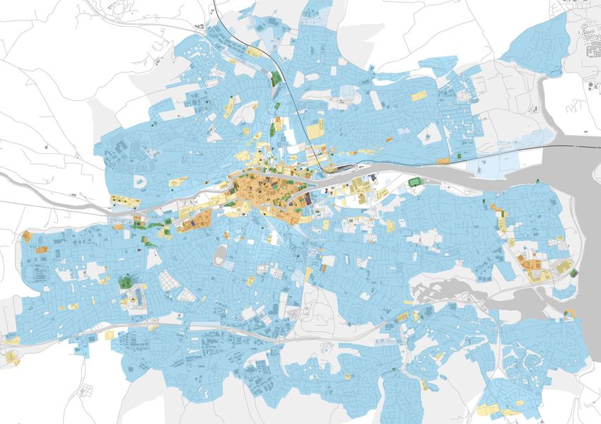
CONTENTS

01 INTRODUCTION..............................................................................................................5
1.1 What is this study about?................................................................................................................................ 7

02 PLANNING POLICY CONTEXT.........................................................................................9
2.1 National Planning Framework..................................................................................................................... 10
2.2 Urban Development and Building Height – Guidelines for Planning Authorities (2018)........................... 10
2.3 Cork City Development Plan (2015-2021).................................................................................................... 11
2.4 North and South Docks LAPs....................................................................................................................... 12
2.5 Cork Metropolitan Area Transport Strategy 2040....................................................................................... 14
2.6 Conclusion..................................................................................................................................................... 17

03 HEIGHT ANALYSIS........................................................................................................ 19
3.1 Existing Context Height and Taller Buildings.............................................................................................. 20
3.2 Permitted Taller Buildings ........................................................................................................................... 22
3.3 Docklands LAPs ........................................................................................................................................... 24
3.4 Taller Building Examples.............................................................................................................................. 25
3.5 Spatial Distribution of Taller Buildings in Cork........................................................................................... 44

04 CONCLUSION................................................................................................................53
4.1 Policy Context ............................................................................................................................................... 54
4.2 Taller Buildings Trend................................................................................................................................... 54
4.3 Summary....................................................................................................................................................... 55

APPENDIX.........................................................................................................................57
Figures for Section 1:
01 Introduction

BUILDING HEIGHT SURVE Y CORK FORMER FORD DISTRIBUTION SITE                 5
Proposed development at the former Ford Distribution Site
1.1 What is this study about?

Urban Initiatives Studio was commissioned by            The report is structured into the following chapters:
Marina Quarter Limited to undertake a Building
Heights Survey that incudes report and maps             1. Introduction
clearly showing the location and details of existing
and permitted buildings in Cork city over 6 storeys     2. Planning Policy Context
in height. The study was requested in An Bord
                                                        Provides a discussion of local and national policies
Pleanala’s Opinion following the pre-application
                                                        and guidance relating to building height and how
consultation in respect of the Strategic Housing
                                                        this steers development of high and tall buildings in
Development at the former Ford Distribution Site,
                                                        Cork.
Centre Park Road, Cork.
This study provides a macro level analysis of           3. Building Height Analysis
buildings and permitted schemes of 6 storeys and
                                                        Presents the spatial distribution of existing
over within Cork City. It discusses the trends of
                                                        and permitted taller buildings in Cork and how
taller building development in the city over time and
                                                        this relates to land use/zoning, transport and
provides a discussion of local and national policies
                                                        topography. The chapter also presents an extensive
relating to building height.
                                                        list of case studies of buildings over 6 storeys and
                                                        tall buildings within Cork.

                                                        4. Conclusion
                                                        Presents a summary of findings, explaining the
                                                        taller building trends within Cork and how the
                                                        proposed development at Former ford Distribution
                                                        Site fits into this trend.

                                                        Appendix
                                                        The Appendix contains tables of the Taller Buildings
                                                        Examples information contained in Chapter 4, for
                                                        reference.

BUILDING HEIGHT SURVE Y CORK FORMER FORD DISTRIBUTION SITE                                                      7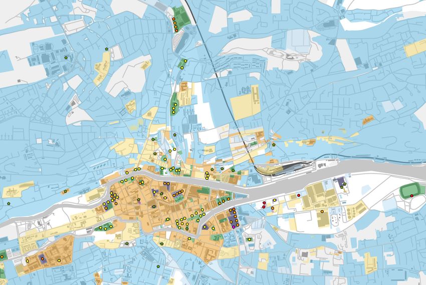
02 Planning Policy Context
                                                             This chapter provides a discussion of local and national
                                                             policies and guidance relating to building height and how
                                                             this steers development of taller and tall buildings in Cork.

BUILDING HEIGHT SURVE Y CORK FORMER FORD DISTRIBUTION SITE                                                                   9
Figures for Section 2:

2.1 National Planning Framework                        2.2 Urban Development and Building Height – Guidelines for Planning Authorities (2018)

The National Planning Framework (NPF) positions        The National Guidance on Urban Development           The guidance requires development plans
Cork as a growing medium-sized European city,          and Building Heights (2018) states that to deliver   to “identify and provide policy support for
which will see much growth over the next 20            housing numbers, thriving city and town centres,     specific geographic locations or precincts
years. The city will see high population growth,       and limit our impact on the environment, Irish       where increased building height is not only
which the NPF states will be accommodated              cities must build upward rather than outward.        desirable but a fundamental policy requirement”.
through intensification of the existing city and       The development of brownfield land and a general     Increased building heights and taller buildings
major regeneration projects as opposed to              increase in density is needed, compared to what      are an important part of making optimal use of
outward sprawl. A key element of this strategy is      has been considered appropriate in the past.         the capacity of sites in urban locations “where
the coupling of higher density development with                                                             transport, employment, services or retail
                                                       Achieving higher density does not automatically
public transport provision to create sustainable                                                            development can achieve a requisite level of
                                                       imply tall buildings, but they can play a role in
development.                                                                                                intensity for sustainability” (para 2.3). The Guidance
                                                       higher density development while achieving
                                                                                                            sets out that there is “a presumption in favour
The plan states:                                       other benefits to placemaking, character and
                                                                                                            of buildings of increased height in our town /city
                                                       distinctiveness.
“Cork already performs well as a major urban                                                                cores and in other urban locations with good public
centre in Ireland and the City has positioned itself   The guidance states that local authorities should    transport accessibility” (para 3.1).
as an emerging medium-sized European centre of         move away from restrictive approaches to
                                                                                                            This more proactive and permissive approach
growth and innovation. Building on this potential is   building height and density, to “making optimal
                                                                                                            undermines the conservative stance on building
critical to further enhancing Ireland’s metropolitan   use of the capacity of sites in urban locations
                                                                                                            height within the current Cork City Development
profile.                                               where transport, employment, services or retail
                                                                                                            Plan, which predates this guidance. Despite current
                                                       development can achieve a requisite level of
This requires an ambitious vision for Cork, at                                                              CDP policies, the planning authority will now need
                                                       intensity for sustainability.”
the heart of which must be an internationally                                                               to adhere to the national guidelines and make use
competitive, sustainable urban environment. This       To facilitate this, the guidance provides            of the development management criteria with it.
means providing housing, transport, amenities          development management criteria that local
and energy systems in a best practice European         authorities must use when determining planning
context.                                               applications for tall buildings. If a development
                                                       proposal complies with the criteria, then a
One of the greatest challenges in achieving
                                                       local authority should approve it even if specific
significant growth that will move the Cork
                                                       objectives of the local development plan would
metropolitan region to the next level is addressing
                                                       prohibit it.
the long term decline of the City’s urban
population.”

10
Amended Volume 1_Layout 1 14/04/2015 12:25 Page 20
2
20
Volume One: Written Statement
LEGEND
City Centre
C
Northwest Regeneration Area
N
K Development Areas
Key
2.3 Cork City Development Plan Future Development Areas
F
RAPID Areas
R
(2015-2021) District Centres
Proposed District Centre
Blackpool
General Height Glanmire
Commuter Rail Fair Hill
Ballyvolane
Indicative Rapid Transport Farranree Blackpool
Corridor Hollyhill
The Cork City Development Plan (2015-2021)
Cork City Development Plan 2015-2021
Existing Primary Roads
Knocknaheeny
K
provides specific guidance on development height Mayfield
Dunkettle
for different parts of the city. Gurranabraher
Kent
Montenotte
Station
Tivoli
Within the city centre and inner urban areas, the height
Sunday’s City Centre
of new development is expected to respond sensitively Well Docklands Blackrock
to the historic scale of Cork. However, in exceptional Ballintemple
circumstances development on corner sites may be Mahon
Ballinlough
allowed an additional 1-2 storeys above the general Ballinure
height to mark the prominent location (16.29-33). Glasheen South
Bishopstown Mahon
Docklands is the largest regeneration site in Cork Wilton
Ballyphehane
Togher
and the City Development Plan promotes in the Tramore
Road
South Docks a general building height at parapet Douglas
of 5-6 storeys and 6-7 storeys in Neighbourhood
Bandon
and District Centres and along the waterfront (Para
13.90). Development in the North Docks should be Figure 2.1: City Development Plan Core Strategy Diagram
Figure 2.1 Core Strategy Diagram
4-6 storeys and up to 7 storeys on the riverfront
(Para. 13.71). Tall Buildings public transport accessibility. The tallest strategic
landmark building in Cork should be located in the
Within suburban areas, development is expected to The Cork City Development Plan defines Tall
Eastern Gateway of the South Docks (next to the
be predominantly low-rise (1-3 storeys). However, Buildings as those over 10 storeys (32m) but does
application site). Another location for a tall building
buildings of 3-5 storeys are considered appropriate concede that “buildings which are taller than
is identified at South Mahon to act as gateway into
in principle on major development areas identified in the general building height in any area will be
the city. Locations of tall buildings are included in
the development plan, and large development sites considered “taller” even where they are less than
Maps 2 and 7 of the CDP.
of greater than 0.5ha. On these sites, local landmark 10 storeys”.
buildings of 20-23m (6-7 storeys) may be acceptable No other parts of the city are considered
The City Development Plan identifies Docklands
in exceptional circumstances (16.27/28). The diagram appropriate for tall buildings, with the historic
and South Mahon as appropriate locations for tall
in Figure 2.1 identifies the key development areas and suburban parts of the city being particularly
buildings and state that tall buildings should be
where this mid-rise development may be acceptable. sensitive to the effects of tall development (16.34)
located only in areas of existing or planned high
BUILDING HEIGHT SURVE Y CORK FORMER FORD DISTRIBUTION SITE 1154
Figure 5.4 Kent Station / Horgan’s Quay
2.4 North and South Docks LAPs
The Local Area Plans (LAPs) for the North and
South Docklands identified locations for tall
buildings and their maximum heights. While these
plans have now lapsed, the South Docks LAP is
still a relevant consideration in relation to height
and is referenced in the CDP. The tallest building is
proposed at the eastern end of the South Docklands
at the Eastern Gateway, at 27 storeys.
See Figure 2.2 (North Docks) and Figure 2.3 (South
Docks).
The height strategy of the proposed scheme aligns
with the height principles of the (outdated) SDLAP,
specifically the location of the tallest element of
the application (14 storeys) on the SW corner of the
subject site, which is identified for a local landmark
building.
Figure 2.2: North Docks LAP - plan showing locations for landmark buildings
(shown as stars) December 2005
NORTH DOCKS LOCAL AREA PLAN
12-PD B M " SF B 1 MB O
*UJTFOWJTBHFEUIBUEFWFMPQNFOUXJMMHFOFSBMMZOPUFYDFFEIFJHIUTBTJOEJDBUFEJO'JHVSF FYDFQUJOUIF 5IFEFWFMPQNFOUPGUIF4PVUI%PDLTXJMMDIBOHFUIFFYJTUJOHMBOETDBQFBOEWJTVBMDPOUFYUPGUIFBSFB
DBTFTPGUIFJEFOUJGJFEUBMMMBOENBSLCVJMEJOHT*OBEEJUJPO UIFDVSSFOUTJHOJGJDBOUQSFTFODFPGRVBZTJEFTJMPT DSFBUJOHBIJHIRVBMJUZ WJCSBOUNJYFEVTFVSCBOBSFBBOEBOFXBOEJOUFSFTUJOHMBOETDBQFDJUZTDBQF*OBMM
UIBUBSFDVSSFOUMZEFTJHOBUFEBTIBWJOHIFSJUBHFWBMVF NBZGPSNBDPOTJEFSBUJPOJOUIFEFTJHOPGSFQMBDFNFOU BQQMJDBUJPOTGPSOFXEFWFMPQNFOU EFTJHOTPMVUJPOTXIJDIBSFJOBDDPSEBODFXJUI4FDUJPOPGUIJT1MBO
TUSVDUVSFTJOUIFFWFOUUIBUUIFJSSFQMBDFNFOUJTQFSNJUUFE8IFSFOFXEFWFMPQNFOUJTMPDBUFEBEKPJOJOH XJMMCFSFRVJSFEBOENVTUEFNPOTUSBUFUIFBDIJFWFNFOUPGTVGGJDJFOUEBZMJHIUTVOMJHIUUPQSPUFDUSFTJEFOUJBM
QSPUFDUFEIFSJUBHFTUSVDUVSFT BTPVUMJOFEJO4FDUJPO IFJHIUTBTJMMVTUSBUFEBSFTVCKFDUUPDIBOHFXIFSF BNFOJUJFT#VJMEJOHIFJHIUTXJMMOPUJOBOZDBTFFYDFFEUIFNBYJNVNTUBUFEGPSUIFBEKBDFOUNBJOTUSFFUT
OFDFTTBSZUPQSPUFDUUIFTFUUJOHPGTVDITUSVDUVSFT
'JHVSF#VJMEJOH)FJHIUTJOUIF4PVUI%PDLT -&(&/%
6QUP4UPSFZTBUQBSBQFU 1SPQPTFE5BMM#VJMEJOHIFJHIUJON0% .BMJO
4UPSFZTFUCBDL &YJTUJOH5BMM#VJMEJOHIFJHIUJON0% .BMJO
4UPSFZTBUQBSBQFU .BJO7JTUBT
4UPSFZTFUCBDL 5BMM-BOENBSL#VJMEJOH
4UPSFZTBUQBSBQFU 'PDBM-BOENBSL#VJMEJOHUPCF
EFTJHOFEBTGPDBMQPJOUTUPNBSLJNQPSUBOU
DPSOFSTBOEUFSNJOBUFWJTUBT
4UPSFZTFUCBDL
,FZ1MBO 4065)%0$,4-0$"-"3&"1-"/
Figure 2.3: South Docks LAP - plan showing locations for landmark buildings
(shown as stars) and general building heights
BUILDING HEIGHT SURVE Y CORK FORMER FORD DISTRIBUTION SITE 132.5 Cork Metropolitan Area Transport
Strategy 2040
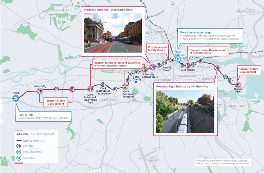
The Cork Metropolitan Area Transport Strategy The Strategy proposes to make use of the existing Light Rail
(CMATS) sets out an ambitious plan for public rail lines to provide a suburban commuting service
The provision of an east-south Light Rail (LRT)
transport and sustainable transport delivery for the with new stations at:
line in Cork City will be central to catalysing
city. The proposals within the Strategy are closely
Midleton / Cobh- Cork Line: redevelopment and intensification in the city, while
tied to the anticipated growth of Metropolitan
delivering an attractive alternative to private car
Cork’s population of an additional 172,000 people to ll Tivoli Docks;
use. The LRT alignment stretches from a Park and
2040, most of which is targeted for Cork City. Public ll Dunkettle; Ride facility in the west into the city centre, and east
transport provision is therefore planned alongside
ll Water Rock; to Mahon Point via Kent Station and Docklands.
intensification of the city. “CMATS aligns with
ll Ballynoe; and The exact alignment of the LRT system is yet to
National Planning Framework objectives to focus
be determined but the Strategy states that the
development and population growth within existing ll Carrigtwohill West.
following locations must be within the catchment
cities and along sustainable transport routes.”
area of the LRT:
Mallow-Cork Line:
The diagram on the right shows the indicative
ll Ballincollig;
public transport network proposed in the strategy. ll Blackpool / Kilbarry;
Rail and LRT proposals are discussed below. ll The proposed Cork Science and Innovation Park
ll Monard; and
(CSIP);
ll Blarney / Stoneview.
Rail Lines ll Cork Institute of Technology (CIT);
Intensification is targeted around existing rail Three of these new stations are within the city; ll Cork University Hospital (CUH);
stations in the first instance to bolster their viability Tivoli Docks, Dunkettle and Blackpool / Killbarry. ll University College Cork (UCC);
and demand, “The consolidation of activity within a These stations will support residential-led mixed ll Cork City Centre;
1km catchment boundary of existing stations along use development of brownfield sites within their
ll Kent Station / Cork North Docklands;
the railway catchment will create better linkages catchment.
with the town centres and stations, support the ll Cork South Docklands; and
viability of the rail corridor and provide a strong ll Mahon.”
justification for the enhancement of existing
services.”
14WHITECHURCH
Indicative Public Transport Network
Blarney / Stoneview
SALLYBROOK
Monard
BLARNEY
BROOKLODGE
TOWER Blackpool/
Kilbarry
GLANMIRE
Carrigtwohill
BLACKPOOL
GLOUNTHAUNE
MAYFIELD Glounthaune MIDLETON
Little Island CARRIGTWOHILL
KNOCKNAHEENEY Tivoli Dunkettle
Kent Station
CORK CITY LITTLE ISLAND
DOCKLANDS Fota
BLACKROCK
BALLINCOLLIG
BISHOPSTOWN
DOUGLAS
PASSAGE WEST
Carrigaloe
ROCHESTOWN
FRANKFIELD
LEGEND - KEY INFORMATION Ballynoe
Rail Corridor
East-West Corridor COBH
MONKSTOWN
Core Bus Corridors
Rushbrooke Cobh
Existing Train Station
CORK
AIRPORT
Proposed Train Station
Industry/Employment RINGASKIDDY
BALLYGARVAN
Residential WHITEGATE
Port CARRIGALINE
Education
Hospital
CROSSBARRY
Retail
Culture All routes and alignments are indicative and subject to
change through the statutory scheme appraisal process.
Figure 2.4: CMATS - Indicative public transport plan
RIVERSTICK
BUILDING HEIGHT SURVE Y CORK FORMER FORD DISTRIBUTION SITE 15
SHANNONThese key locations must be served by LRT to
achieve some of the key aims of the Strategy,
including:
ll “Unlock strategic development areas in its
catchment area including the Cork City Docks,
Curraheen, Ballincollig and Mahon;
ll Maximise the development potential of windfall
sites;
ll Provide greater certainty for future planning
and development, to pursue higher densities
required to meet NPF population and
employment targets for Cork City;
ll Underpin the planned expansion of University
College Cork (UCC), Cork Institute of Technology
(CIT) and Cork University Hospital (CUH).
ll Enable car-free and low car development within
its catchment in line with recent changes to
government policy outlined in the NPF and
Sustainable Apartment guidelines;
ll Reduce reliance on the N40 in particular, for
short trips within the Metropolitan Area;”
Figure 2.5: CMATS - Light rail route alignment
162.6 Conclusion
The existing City Development Plan (CDP) for CMATS does not provide details on the densities
Cork was adopted in 2015. Cork City Council or units to be delivered on particular sites, but
commenced the review of the City Development it does presume that areas supported by high
Plan on June 26th, 2020. This is 2 year process quality public transport will be of higher density,
which will be completed with the adoption of a new in line with the National Planning Framework and
Development Plan in 2022. Because of its age, national guidance on Urban Development and
it predates the National Planning Framework, Building Height. Therefore, it can be argued that
National Development Plan and guidance on Urban development in locations of high public transport
Development and Building Heights, which all take a accessibility should have a general increase in
positive approach to sustainable urban density. height beyond what has traditionally been delivered
in Cork, particularly in suburban locations.
Therefore, the CDP’s relatively conservative
approach to building heights and tall buildings is
considered out of date and will likely be updated in
line with national policy in the 2022 CDP. However,
it is still the adopted and current local plan and
the key development and regeneration locations
identified within the plan are still relevant.
The more recent Cork Metropolitan Area Transport
Strategy (CMATS) provides an insight into where
higher density (and therefore taller) development is
likely to be prioritised in coming years, in line with
public transport investment.
BUILDING HEIGHT SURVE Y CORK FORMER FORD DISTRIBUTION SITE 1703 Height Analysis
This chapter contains the height analysis undertaken for the
Cork city area.
Firstly it includes the mapping of general heights and the
identification of taller development (buildings above 6
storeys or 18m for non-residential buildings).
Secondly it provides a timeline and analysis of 45 case
studies of taller developments in Cork (both existing and
permitted).
Lastly it provides an analysis of the spatial distribution of
taller developments in Cork in respect of land uses, road
network, public transport network and topography.
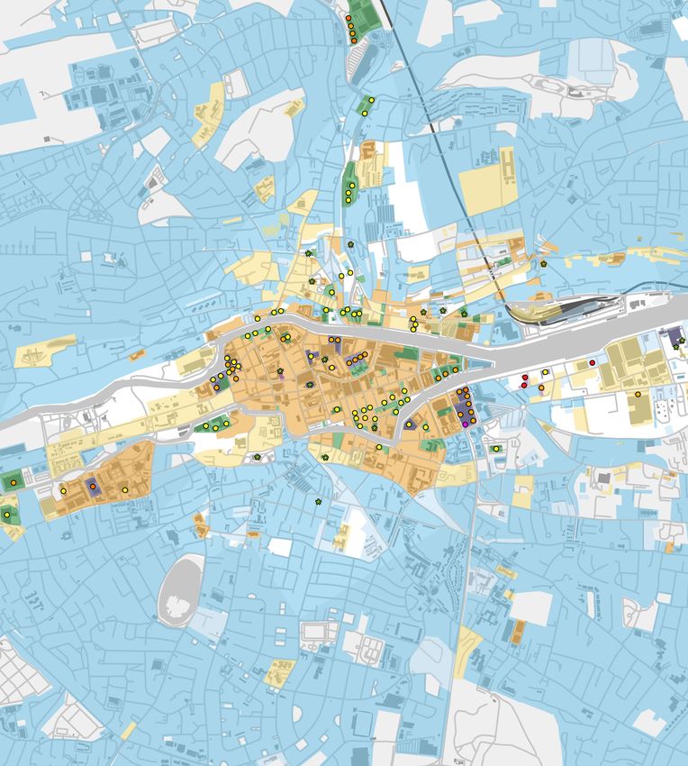
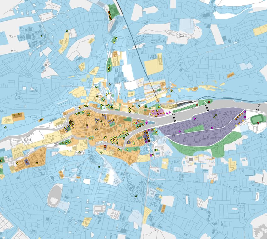
BUILDING HEIGHT SURVE Y CORK FORMER FORD DISTRIBUTION SITE 19Figures for Section 3: 3.1 Existing Context Height and Taller Buildings This study undertook a height analysis of Cork that identified prevailing heights for sub-areas within Cork. The assessment was based on visually observing and identifying height based on freely available 3d mapping on Google Earth, supplemented by Google Street View. As part of this assessment taller buildings of six or more storeys (18m plus for non-residential buildings) were identified and their height range mapped. Figure 3.1 shows the mapping for the city centre and Figure 3.2 for the wider Cork city area. The city centre exhibits a strong 4 storey context height with buildings here generally in the range of 3-5 storeys. The inner urban area steps down in places to 3 storeys and the wider suburbs are consistently 2 storeys in height. Some larger developments set their own context height, resulting in pockets of increased height, such as at University College Cork Campus (4 storey context height), The Elysian and One Albert Quay developments (7 storey context height), but also in places along the North and South Channel Figure 3.1: Existing context height and buildings of 6 storeys and above - city centre (for key see Figure 3.2) in the city centre (5-6 storeys). The majority of existing taller buildings (6+ storeys) area in the 6-7 storeys category. Buildings with a University College Cork, at the Docklands and at are concentrated in the city centre, but outside height above 8 storeys (or equivalent) can be found Mahon. Apart from numerous church spires and of the historical core of the city. There are also to the east of the city centre on the South Channel chimneys (primarily in the city centre and inner pockets of taller buildings located outside of the (Lapps Quay and Albert Quay), to the north of St urban areas) there are currently only four buildings city centre. These are generally associated with Patrick Street, at the Mercy University Hospital, at over the equivalent height of 12 residential storeys institutions such as hospitals and universities or the edge of Blackpool retail park, at the Western in Cork. These are two industrial silos in the commercial developments such as the Blackpool end of the city around County Hall and on Western Docklands, County Hall and the Elysian Tower. retail park. The greatest number of taller buildings Road, at the Cork University Hospital, at the 20
Figure 3.2: Existing context height and buildings of 6 storeys and above - city

BUILDING HEIGHT SURVE Y CORK FORMER FORD DISTRIBUTION SITE                        21
Note: Heights shown on the Former Ford Distribution site are those of existing planning permission (ref: 0832919)
3.2 Permitted Taller Buildings

The study identifies recent planning permissions
for taller development to understand trends in
recent development, even if buildings have not been
constructed. This is based on the wider team’s
knowledge of recent development activity in Cork
and subsequent search on the Cork City Council
planning search website.
The locations and heights of planning permission for
taller buildings are shown in Figure 3.3 and Figure
3.4 alongside the existing tall buildings and context
heights. Planning permissions are denoted with a
dashed outline around the sites and the indicated
heights. Note that for completeness on trends, the
tall building proposal for the Cork Custom House
site is included in the mapping although it is still
under consideration.
Permitted new taller development are primarily
located in a number of areas:
City Harbour Interchange Area - emerging cluster
of taller buildings in the area where the inner
city meets the Docklands, resulting in a general
increase in building height here.
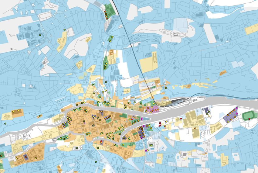
Eastern Dockland - a long-standing permission for a       Figure 3.3: Existing and permitted context height and buildings of 6 storeys and above - city centre (for key see Figure 3.4)
cluster of tall buildings and taller development on the
Former Ford Distribution Site in the Docklands.           The majority of recent planning permissions                           ll   Prism, Albert Quay and Custom House
                                                          includes buildings of 8 storeys and higher. Many                           Quay (pending decision) in the City Harbour
Carrigrohane Road - two new taller buildings have
                                                          comprise a number of taller buildings with a typical                       Interchange Area;
consent as student accommodation to serve UCC.
                                                          range from the equivalent of 6 to 10/11 storeys in                    ll   Railway Gardens at the edge of the city centre on
These schemes will add to the already increased
                                                          height.                                                                    South Link Road;
height around the Cork County Council offices.
                                                          A number of buildings of 12 and more storeys have                     ll   Former Ford Distribution Site in the Eastern
Mahon - a 25 storey tower is permitted to act as a
                                                          been permitted. These are:                                                 Docklands; and
gateway to the city from the south.
                                                          ll   Sullivans Quay on South Channel in the city centre;              ll   Jacob’s Island in Mahon.

22
Figure 3.4: Existing and permitted context height and buildings of 6 storeys and above - city Note: Heights shown on the Former Ford Distribution site
are those of existing planning permission (ref: 0832919)
BUILDING HEIGHT SURVE Y CORK FORMER FORD DISTRIBUTION SITE 23Note: Heights shown on the Former Ford Distribution site are those of existing planning permission (ref: 0832919)
3.3 Docklands LAPs
Previous plans by the city for the Docklands
development proposed generally greater heights
than in other areas of the city. Figure 3.5 shows
the general height and landmark tall buildings
envisioned in the South Docks and North Docks
Local Area Plans (LAPs) in addition to the height
mapping of existing and permitted development.
In the North Docks Area the general building
height would be 5-6 storeys and in the South Docks
Area generally 6-7 storeys. The LAPs also identify
locations for 8 tall buildings above 16 storeys.
Development coming forward in the Docklands
under these guidance would principally fall into the
taller development category.
Figure 3.5: Existing and permitted context height and buildings of 6 storeys and above with Docklands LAPs - city centre
243.4 Taller Building Examples
This section provides an overview of 45 existing The oldest taller buildings in Cork were responses This decade also saw the development of
and permitted taller buildings in Cork. This covers to a particular need that required an increase in comparatively tall buildings outside the city centre,
the majority of taller buildings in the city and is a height above the surroundings. For instance, Mercy most notably the Blackpool Retail Park, which
representative sample to understand height trends University Hospital needed to maximise the space features a 9 storey tower and expansion of UCC
in the city. available for patients within a constrained urban with the Victoria Mills student accommodation and
site and so was constructed to 6 storeys. The large Western Gateway Building.
Taller building examples are ordered in respect of
industrial structures of R&H Hall and Arcady Feed
the period when they were built or permitted. The 2010s did not see many taller building
were responses to the need for large storage space
developments delivered as the city recovered
Figure 3.6 to Figure 3.10 on the following page show within the busy Docklands.
from the 2008 financial crisis. However, developer
the locations of the case study sites, with existing
Towards the middle of the 20th Century, large interest has been high in the last number of years,
tall buildings numbered from 1 to 28 in BLACK and
institutions turned to taller buildings to allow for resulting in a pipeline of schemes with planning
permitted tall buildings numbered 1 to 17 in BLUE.
expansion, resulting in County Hall and the UCC permission.
Kane Building, which provide intense provision of
Findings: Permitted taller buildings are focused on the
office space at 17 and 7 storeys, respectively.
City Harbour Interchange Area with the familiar
The 2000s is the decade that saw the most taller
Skipping forward to the 2000s, the era of the Celtic residential and office focus. A number of hotels and
building development in Cork with 15 examples
Tiger sees a resurgence in living and working in student accommodation developments have also
of that era. In contrast, the sample contains only
the city centre. Brownfield sites were redeveloped been granted consent. However, differing form the
10 taller buildings that were constructed during
into intense, mixed use schemes. This era sees the 2000s surge of modest tall buildings, the emerging
the 20th century, which still survive in Cork. Four
first high density residential buildings in Cork, a city development exhibit a much greater variety of
of these from are from the 1960s. Only two of the
otherwise dominated by single occupier housing. heights and higher overall heights.
examples compiled here were built in the last
decade (2010s). However, there has been a surge Apartment buildings and offices proliferated at a For instance, the Railway Gardens residential
in planning applications for taller development in general height of 6 storeys. This height is taller scheme includes heights from 4 to 17 storeys. 2
the last number of years, with proposals for 10 than the predominantly 4 storey historic centre of Albert Quay has permission for a residential-led
developments approved in 2018 and 2019 alone. Cork but remains of a contextual scale within this mixed use building that steps from 8 to 24 storeys.
more sensitive environment. In 2009 the 17 storey The proposed hotel on the Custom House site is
Elysian apartment building was completed which still under consideration but if permitted would be
was the first tall building in the city since 50 years the tallest building in the Republic of Ireland at 140
and at the time of building the tallest tower in the metres.
Republic of Ireland.
BUILDING HEIGHT SURVE Y CORK FORMER FORD DISTRIBUTION SITE 2511
9 17
13 15
10 7
1 6 2 8
14
10 17
4 16
13 15 11 12 5 20 21 16 4
6 22
27
19
12 23
5
3
14
7
Figure 3.6: Taller building examples - West Figure 3.7: Taller building examples - City Centre
2626
24
18
Figure 3.8: Taller building examples - North
25 9
3
2
8 1 28
Note: Heights shown on the Former Ford Distribution site
are those of existing planning permission (ref: 0832919)
Figure 3.9: Taller building examples - Docklands Figure 3.10: Taller building examples - East
BUILDING HEIGHT SURVE Y CORK FORMER FORD DISTRIBUTION SITE 27Examples: Existing Taller Buildings 1. Mercy University Hospital 2. R & H Hall 3. Arcady Feed Ltd Height Range (storeys) 4-6 Height Range (storeys) N/A Height Range (storeys) N/A Max Height (metres) 28m Max Height (metres) 40m Max Height (metres) 41m Use Hospital Use Industrial Use Industrial Period Build 19th Century and 1960s Period Build 1940s Period Build Mid-20th Century Location Inner Urban Location Docklands Location Docklands Development Context Institutional Development Context Docklands Industry Development Context Docklands Industry 28
4. County Hall                                   5. Kane Building                                   6. Gardner House
Height Range (Storeys)   3-17                    Height Range (Storeys)   7                         Height Range (Storeys)   6
Max Height (metres)      67m                     Max Height (metres)      32m                       Max Height (metres)      24m
Use                      Office                  Use                      University                Use                      Office
Period Build             1960s (Tower) and       Period Build             1960s                     Period Build             1960s
                         2000s (Extension)
                                                 Location                 Suburban                  Location                 Inner Urban
Location                 Suburban
                                                 Development Context      Institutional Expansion   Development Context      Brownfield
Development Context      Institutional                                                                                       Development

BUILDING HEIGHT SURVE Y CORK FORMER FORD DISTRIBUTION SITE                                                                                 29
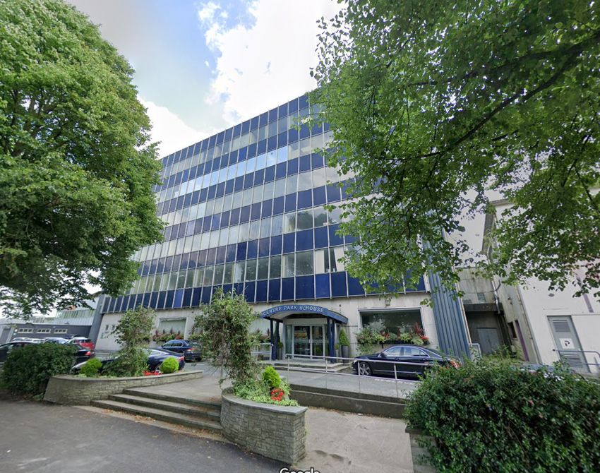
7. Cork University Hospital 8. Centre Park House 9. Pope’s Quay
Height Range (Storeys) 1-6 Height Range (Storeys) 6 Height Range (Storeys) 5-6
Max Height (metres) 33m Max Height (metres) 26m Max Height (metres) 18m
Use Hospital Use Office Use Retail and Residential
Period Build 1970s and 2000s Period Build Pre-Millennium Period Build Pre-Millennium
Location Suburban Location Docklands Location Inner Urban
Development Context Institutional Development Context Docklands Commercial Development Context Urban Redevelopment
Development
3010. North Main Street Car Park 11. Victoria Mills 12. Western Gateway Building
Height Range (Storeys) 6 Height Range (Storeys) 4-9 Height Range (Storeys) 5
Max Height (metres) 28m Max Height (metres) 28m Max Height (metres) 23m
Use Car Park Use Student Use University
Accommodation
Period Build 2000s Period Build 2000s
Period Build 2000s
Location City Centre Location Suburban
Location Suburban
Development Context Urban Redevelopment Development Context University Brownfield
Development Context Regeneration of Development
Industrial Site
BUILDING HEIGHT SURVE Y CORK FORMER FORD DISTRIBUTION SITE 3113. The Gate 14. Cornmarket Centre 15. 20-21 Lavitt’s Quay Height Range (Storeys) 4-6 Height Range (Storeys) 6 Height Range (Storeys) 6 Max Height (metres) 19m Max Height (metres) 23m Max Height (metres) 27m Use Cinema and Residential Use Retail Use Retail and Office Period Build 2000s Period Build 2000s Period Build 2000s Location Inner Urban Location City Centre Location City Centre Development Context Urban Redevelopment Development Context Urban Redevelopment Development Context Urban Redevelopment 32
16. Opera Lane                                    17. Camden Wharf                                  18. Seana Mhuileann Apartments
Height Range (Storeys)   7                        Height Range (Storeys)   4-6                      Height Range (Storeys)   4-7
Max Height (metres)      22m                      Max Height (metres)      22m                      Max Height (metres)      25m
Use                      Retail and Residential   Use                      Residential and Retail   Use                      Residential
Period Build             2000s                    Period Build             2000s                    Period Build             2000s
Location                 City Centre              Location                 Inner Urban              Location                 Suburban
Development Context      Urban Redevelopment      Development Context      Urban Redevelopment      Development Context      Suburban Brownfield
                                                                                                                             Development

BUILDING HEIGHT SURVE Y CORK FORMER FORD DISTRIBUTION SITE                                                                                         33
19. Cork School of Music (CIT) 20. 5-6 Lapp’s Quay 21. City Quarter Height Range (Storeys) 7 Height Range (Storeys) 7 Height Range (Storeys) 8 Max Height (metres) 28m Max Height (metres) 27m Max Height (metres) 27m Use Education Use Office Use Hotel, Office and Retail Period Build 2000s Period Build 2000s Period Build 2000s Location Inner Urban Location Inner Urban Location Inner Urban Development Context Urban Redevelopment Development Context Urban Redevelopment Development Context Urban Redevelopment 34
22. One Albert Quay                              23. The Elysian                                   24. Blackrock Mews
Height Range (Storeys)   7                       Height Range (Storeys)   7-17                     Height Range (Storeys)   3-6
Max Height (metres)      32m                     Max Height (metres)      71m                      Max Height (metres)      19m
Use                      Office                  Use                      Retail and Residential   Use                      Residential
Period Build             2000s                   Period Build             2000s                    Period Build             2000s
Location                 Inner Urban             Location                 Inner Urban              Location                 Suburban
Development Context      Urban Redevelopment     Development Context      Urban Redevelopment      Development Context      Greenfield Residential
                                                                                                                            Development

BUILDING HEIGHT SURVE Y CORK FORMER FORD DISTRIBUTION SITE                                                                                           35
25. The Sanctuary, Jacop’s Island 26. Blackpool Retail Park 27. River Lee Hotel / Lancaster Gate Apartments
Height Range (Storeys) 6-8 Height Range (Storeys) 4-9 Height Range (Storeys) 3-7
Max Height (metres) 24m Max Height (metres) 35m Max Height (metres) 22
Use Residential Use Retail and Residential Use Hotel and Residential
Period Build 2000s Period Build 2000s Period Build 2010s
Location Suburban/Gateway Location Suburban Location Inner Urban
Development Context Greenfield Residential Development Context Out of Town Retail / Development Context Urban Redevelopment
Development Greenfield Development
3628. Párc Uí Chaoimh
Height Range (Storeys) N/A
Max Height (metres) 36m
Use Stadium
Period Build Built 1970s and
redeveloped 2010s
Location Docklands
Development Context Docklands
Redevelopment
BUILDING HEIGHT SURVE Y CORK FORMER FORD DISTRIBUTION SITE 37Case Studies: Permitted Tall Buildings
1. Former Ford Distribution Site 2. Anderson’s Quay 3. Trinity Quarter
Height Range (Storeys) 4-27 Height Range (Storeys) 6 (office storeys) Height Range (Storeys) 6 (office storeys)
Max Height (metres) 107m Max Height (metres) 39 Max Height (metres) Unknown
Use Residential, Retail, Use Retail and Office Use Office and University
Hotel, other
Year Permitted 2010 Year Permitted 2010
Year Permitted 2009
Location Inner Urban Location Inner Urban
Location Docklands
Development Context Urban Redevelopment Development Context Urban Redevelopment
Development Context Brownfield
Development Status Granted Status Granted
Status Granted Reference Number 0934001 Reference Number 934049
Reference Number 0832919
384. Navigation Square 5. Sullivan’s Quay 6. Prism Building
Height Range (Storeys) 6 (office storeys) Height Range (Storeys) 6-12 Height Range (Storeys) 15
Max Height (metres) 31 Max Height (metres) 44.5m Max Height (metres) 70m
Use Office Use Hotel and Office Use Office
Year Permitted 2016 Year Permitted 2017 Year Permitted 2018
Location Inner Urban Location Inner Urban Location Inner Urban
Development Context Urban Redevelopment Development Context Urban Redevelopment Development Context Urban Redevelopment
Status Granted Status Granted / Under Status Granted / Under
Construction Construction
Reference Number 1636773
Reference Number 1737436 Reference Number 1837894
BUILDING HEIGHT SURVE Y CORK FORMER FORD DISTRIBUTION SITE 397. Penrose Dock 8. Horgan’s Quay 9. Jacob’s Island
Height Range (Storeys) 7-9 Height Range (Storeys) 7-11 Height Range (Storeys) 6-25
Max Height (metres) 40m Max Height (metres) 38m Max Height (metres) 83m
Use Office Use Office, Hotel,Residential Use Residential
Year Permitted 2018 Year Permitted 2018 Year Permitted 2018
Location Docklands Location Docklands Location Suburban / Gateway
Development Context Regeneration of Development Context Regeneration of Development Context Greenfield Residential
Industrial Site Industrial Site Development
Status Granted Status Granted / Under Status Granted
Construction
Reference Number 1837909 Reference Number PL28.301991
Reference Number 1737563
4010. Parnell Place 11. Good Shepherd Convent 12. Former Beamish Site
Height Range (Storeys) 3-7 Height Range (Storeys) 6 Height Range (Storeys) 7
Max Height (metres) 25m Max Height (metres) Unknown Max Height (metres) Unknown
Use Hotel Use Residential Use Events Centre, Student
Accom. and Office
Year Permitted 2018 Year Permitted 2018
Year Permitted 2018
Location Inner Urban Location Suburban
Location City Centre
Development Context Urban Redevelopment Development Context Suburban
Redevelopment Development Context Urban Redevelopment
Status Granted
Status Granted Status Granted / Under
Reference Number 1838009 Construction
Reference Number 1737279
Reference Number 1837773
BUILDING HEIGHT SURVE Y CORK FORMER FORD DISTRIBUTION SITE 4113. Former Coca-Cola Site 14. Railway Gardens 15. Crow’s Nest
Height Range (Storeys) 6-10 Height Range (Storeys) 4-17 Height Range (Storeys) 7-10
Max Height (metres) Unknown Max Height (metres) 58.5m Max Height (metres) 36m
Use Student Use Residential Use Student
Accommodation Accommodation
Year Permitted 2019
Year Permitted 2019 Year Permitted 2019
Location Inner Urban
Location Suburban Location Suburban
Development Context Urban Redevelopment
Development Context Regeneration of Development Context Urban Redevelopment
Industrial Site Status Granted
Status Granted / Under
Status Granted Reference Number PL28.305173 Construction
Reference Number 1938242 Reference Number PL28.300325
4216. 2 Albert Quay 17. Custom House
Height Range (Storeys) 8-24 Height Range (Storeys) 3-34
Max Height (metres) 87m Max Height (metres) 140m
Use Retail and Residential Use Hotel, Retail and
Culture
Year Permitted 2020
Year Permitted N/A
Location Inner Urban
Location Inner Urban
Development Context Urban Redevelopment
Development Context Urban Redevelopment
Status Granted
Status Under Consideration
Reference Number PL28.305779
Reference Number 1938589
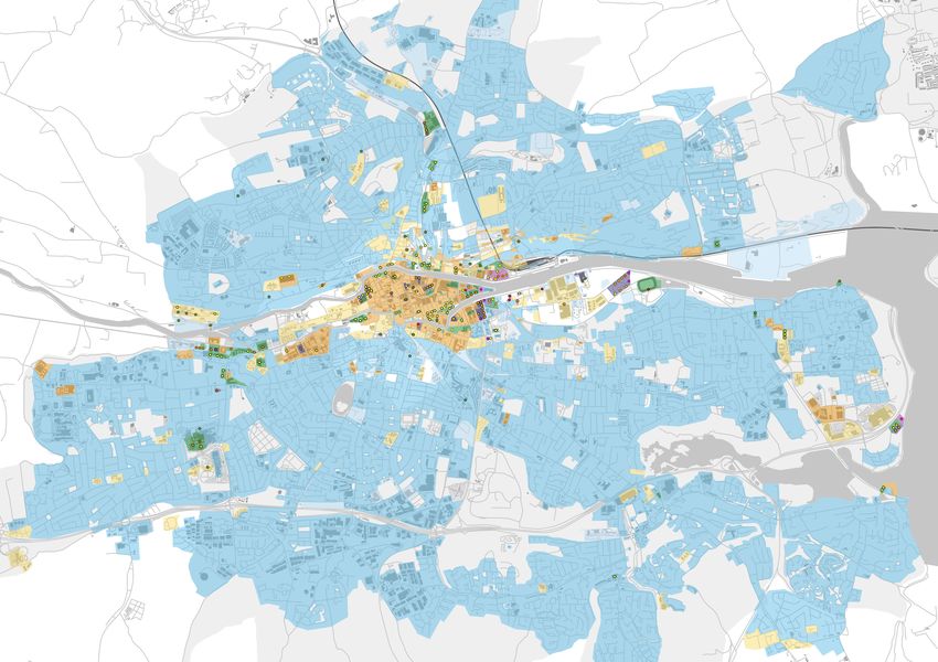
BUILDING HEIGHT SURVE Y CORK FORMER FORD DISTRIBUTION SITE 433.5 Spatial Distribution of Taller Buildings Figure 3.11: (to right) Character Areas with
existing and permitted buildings of six storeys
in Cork and above
This section discusses the spatial distribution of
taller buildings in Cork in relation to character
areas, transport and topography. These topics are
discussed below, with relevant maps presented on
the following pages.
Character Areas
Figure 3.11 on page 44presents existing and Apart from a few exceptions there are no taller
permitted taller buildings in relation to the broad buildings within out of city centre retail parks, high
identification of character areas within the city. streets and shopping parades, business parks,
The character areas are based on the Landscape industrial areas and suburban residential areas.
Character Areas in Figure 10.1 within the City
Development Plan, supplemented by qualitative
assessment by the author of this study.
Existing and permitted taller buildings are
principally located in the following character areas:
ll Highest concentration in the Mixed use
commercial area
ll Few modest taller buildings at the northern edge
of the Old town
ll Two pockets within the inner city retail area
(north of St. Patricks Street)
ll Concentration within some Institutional /
campus environments
ll Few in the inner city residential neighbourhood
(north of the North Channel)
ll Docklands (Eastern and Western ends)
44Note: Heights shown on the Former Ford Distribution site are those of existing planning permission (ref: 0832919) BUILDING HEIGHT SURVE Y CORK FORMER FORD DISTRIBUTION SITE 45
Road Network                                            Figure 3.12: (to right) Road network with existing
                                                        and permitted buildings of six storeys and above
Figure 3.12 on page 46 presents the existing and
permitted tall buildings overlaid on the city’s road
network. There is a clear relationship between
Cork’s road hierarchy and the location of taller
buildings, as the main corridors (National Roads
and Primary Local Roads) have attracted more
intense and taller development.
Existing taller buildings are established along the
N20, which bring traffic into Cork from the north,
particularly at Blackpool Retail Park. The N22, the
route into the city from the west, has a long history
of taller buildings with County Hall and University
College Cork present here, with further tall
development to house students coming on-stream.
The N27 is the main route from the south and
the where it meets the city centre at Albert Quay
has become a hotspot for taller buildings over
the last 15 years, and continues to attract taller
building applications. Finally, the N40 at Mahon is
earmarked for a landmark tall building to mark this
location as a gateway.

46
Note: Heights shown on the Former Ford Distribution site are those of existing planning permission (ref: 0832919) BUILDING HEIGHT SURVE Y CORK FORMER FORD DISTRIBUTION SITE 47
Public Transport Network                                Figure 3.13: (to right) CMATS public transport
Figure 3.13 on page 48presents the existing and         with existing and permitted buildings of six
                                                        storeys and above
permitted taller buildings overlaid on the existing
public transport network and the proposals within
the Cork Metropolitan Area Transport Strategy
(CMATS).
Existing and permitted taller buildings are clearly
located in close proximity to existing and planned
public transport infrastructure. Taller buildings can
be found in:
ll   In the city centre where they benefit from a
     concentration of bus routes;
ll   Around Kent Railway Station;
ll   Along the bus corridor to Blackpool; and
ll   On the proposed east-west light rail line the
     connect the Western Suburb with the Docklands
     and Mahon.

48
Note: Heights shown on the Former Ford Distribution site are those of existing planning permission (ref: 0832919) BUILDING HEIGHT SURVE Y CORK FORMER FORD DISTRIBUTION SITE 49
Topography                                                 Figure 3.14: Topography with existing and
Figure 3.14 on page 50shows the existing and               permitted buildings of six storeys and above
permitted taller buildings overlaid on Cork’s
topography.
The topography of Cork is a distinguishing
characteristic of the city. It rises from almost sea
level at the River Lee up to 180m in the surrounding
countryside. The elevation of the land can
drastically affect the visibility of taller buildings.
The overwhelming majority of taller buildings
in Cork are located at the bottom of the river
valley below the 10m contour. Only a few taller
developments are within the 10-20m contour,
the majority of which are within the River
Bride Valley to Blackpool, but also at UCC and
Blackrock . Outliers are a few taller buildings at
the Cork University Hospital and the Atkin’s Hall
development that are above the 30m and 40m
contour line respectively but well outside the city
centre and not prominent on the city centre skyline.
Given their generally low altitude very few taller
buildings are reaching above 40m in elevation.
As such they are less prominent in the landscape
setting of the city and also interfere less with views
to the spires of the city. Taller buildings north of the
city centre along the N20 are essentially hidden in
the valley of the River Bride.

50
Note: Heights shown on the Former Ford Distribution site are those of existing planning permission (ref: 0832919)

BUILDING HEIGHT SURVE Y CORK FORMER FORD DISTRIBUTION SITE                                                                                                                 51
52
04 Conclusion

BUILDING HEIGHT SURVE Y CORK FORMER FORD DISTRIBUTION SITE               53
Figures for Section 4:

4.1 Policy Context                                   4.2 Taller Buildings Trend

The Cork City Development Plan takes a               20th Century                                            2010-2019
conservative approach to building heights in the
                                                     A small number of taller buildings were                 The last decade has seen very few taller buildings
city, making provision for only a small number of
                                                     constructed in Cork during the 20th century,            come forward in Cork as the economy recovered
tall buildings in the Docklands and at Mahon. This
                                                     particularly during the 1960s. These were singular      from the recession. However, in the last number
approach is now out of date in light of the more
                                                     exceptional tall buildings developed as a way of        of years there has been a considerable number of
recently published National Policy Framework and
                                                     expanding institutions, such as Cork County Council     taller building applications granted consent. These
guidelines on urban building height, which place
                                                     or University College Cork. They were rare and          proposals show a new approach to building tall in
a strong emphasis on sustainable development
                                                     tended to create a deliberate contrast as they rose     Cork.
and the intensification of city centres. This is
                                                     above the existing context height.
encouraging higher and taller buildings to become                                                            Proposals for taller buildings are concentrated on
more commonplace in cities across Ireland                                                                    the City-Harbour Interchange and North Docks.
                                                     2000-2009
including Cork especially in places where they                                                               Taller buildings are also coming forward on a
can benefit from enhanced public transport           The 2000s decade was the most prolific period           number of other sites within the city centre and
accessibility and in centres.                        for taller development in Cork. During this time,       west of the city centre, around UCC.
                                                     a large number of developments came forward
                                                                                                             Most of the proposed developments have a much
                                                     in the city centre and around UCC in the west of
                                                                                                             higher maximum height to the modest 6-7 storey
                                                     the city. These taller buildings generally rise just
                                                                                                             taller buildings of the 2000s. They also present
                                                     slightly above the context height, with the majority
                                                                                                             a much greater variation in heights, generally
                                                     of development at 6-7 storeys in height, with little
                                                                                                             stepping up from the lower context height to the
                                                     variation.
                                                                                                             tallest element. For instance, the consented mixed
                                                     Taller buildings of this decade include office, hotel   use development at 2 Albert Quay rises from 8 to
                                                     and residential development. Some of the buildings      24 storeys. Similarly, the Railway Gardens scheme
                                                     are mixed-use, providing retail units on the ground     varies between 4 and 17 storeys tall.
                                                     floor with apartments or offices above.
                                                                                                             The use of proposed taller buildings is greatly
                                                                                                             mixed, including residential apartments, office
                                                                                                             and hotel use within the city centre and City
                                                                                                             Harbour Interchange and student accommodation
                                                                                                             to the west of the city, to serve UCC. Most of the
                                                                                                             proposals are mixed use in nature, providing retail
                                                                                                             units on the ground floor. The majority of proposals
                                                                                                             are located at public transport hubs or corridors.

54
4.3 Existing Granted Scheme Comparison
The Former Ford Distribution site has a
long-standing planning permission for 564
residential units; 31,777 sq.m. of offices; a 205
bedroom hotel and a 5,000 person capacity Events
Centre (planning reference number 08/32919). The
proposal includes 12 buildings ranging in height
from 1 to 27 storeys. The tallest building on the site
would measure approximately 107m in height. The
typical height of the permitted development would
be 8 commercial storeys (approx. 34m).
The current proposal for the site (this application)
is largely residential in nature, with a height
range of 4 to 14 residential storeys (approximately
18m - 47m). The buildings on the edges of the site
are typically 10/11 storeys (33-37m), with lower
development within the site of typically 8 storeys
(27m).
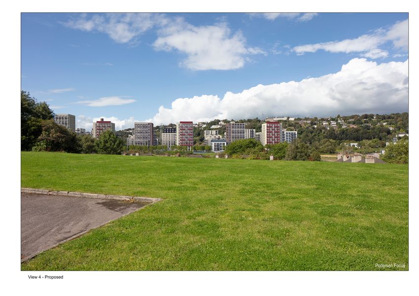
Figure 4.1 shows a photomontage of the proposed
scheme with the existing permitted scheme shown
in red outline. See also Figure 4.2 and Figure 4.3
on page 56. It is clear that the current proposal
would have a broadly similar typical height to the
consented scheme, but without the extremely
tall elements on the eastern edge. Note that a
new proposal for a tall building on the eastern
edge of the site is being prepared separately. Figure 4.1: View 8 - Proposed development with visible outline (in red) of currently Granted Scheme (Planning Ref. no.: 08/32919)
Source: Pederson Focus
Furthermore, the current proposal displays greater
modulation and variation of height generally,
avoiding the appearance of a monotonous “wall” of
development.
BUILDING HEIGHT SURVE Y CORK FORMER FORD DISTRIBUTION SITE 55Figure 4.2: View 17 - Proposed development with visible outline (in red) of currently Granted Scheme (Planning Ref. no.: 08/32919) Source: Pederson Focus Figure 4.3: View 4 - Proposed development with visible outline (in red) of currently Granted Scheme (Planning Ref. no.: 08/32919) Source: Pederson Focus 56
4.4 Summary

This document has presented the key trends of
taller buildings in cork. It is clear that the proposed
development on the Former Ford Distribution Site
would fit into this trend for the following reasons:
ll   It is located within the Docklands on a site
     identified within city policy for regeneration
     and as being suitable for intense and tall
     development;
ll   Its proximity to the primary road network and
     being accessible by the future light rail line;
ll   The site elevation is low (almost sea level) and so
     the proposed taller buildings will not be overly
     dominant on the cityscape;
ll   The height range of 4-14 storeys is in keeping
     with the current trend of intensifying appropriate
     sites and creating a variation in heights.
ll   Pairc Ui Chaoimh sets a local precedent
     for increased height, which the proposed
     development responds well to.
ll   The proposed height would provide enclosure
     and definition to Marina Park and the
     development would provide passive surveillance
     into the park, supporting a sense of safety. The
     proposed scale of development is an appropriate
     response to the scale and amenity afforded by
     the proximity of Marina Park.
ll   The proposed development generally represents
     an improvement over the existing permission
     (ref: 08/32919).

BUILDING HEIGHT SURVE Y CORK FORMER FORD DISTRIBUTION SITE   57
58
Appendix

BUILDING HEIGHT SURVE Y CORK FORMER FORD DISTRIBUTION SITE          59
Table of Existing Taller Building Examples

No.   Name                         Height      Max      Use                 Era Built                     Location      Development Context
                                   Range       Height
                                   (storeys)   (m)
1     Mercy University Hospital    4-6         28       Hospital            19th Century and 1960s        Inner Urban   Institutional
2     R & H Hall                   N/A         40       Industrial          1940s                         Docklands     Docklands Industry
3     Arcady Feed Ltd              N/A         41       Industrial          Mid-20th Century              Docklands     Docklands Industry
4     County Hall                  3-17        67       Office              Tower: 1960s, Lower           Suburban      Institutional
                                                                            Element:2000s
5     Kane Building                7           32       University          1960s                         Suburban      Institutional Expansion
6     Gardner House                6           24       Office              1960s                         Inner Urban   Brownfield Development
7     Cork University Hospital     1-6         33       Hosptial            Original structure: 1970s.    Suburban      Institutional
                                                                            Additional buildings: 2000s
8     Centre Park House            6           26       Office              Pre-millennium                Docklands     Docklands Commercial
                                                                                                                        Development
9     Pope’s Quay                  5-6         18       Retail and          Pre-millennium                Inner Urban   Urban Redevelopment
                                                        Residential
10    North Main Street Car Park   6           28       Car Park            Pre-millennium                City Centre   Urban Redevelopment
11    Victoria Mills               4-9         28       Student             2000s                         Suburban      Regeneration of Industrial
                                                        Accommodation                                                   Site
12    Western Gateway Building     5           23       University          2000s                         Suburban      University Brownfield
                                                                                                                        Development
13    The Gate                     4-6         19       Cinema and          2000s                         Inner Urban   Urban Redevelopment
                                                        Residential
14    Cornmarket Centre            6           23       Retail              2000s                         City centre   Urban Redevelopment
15    20-21 Lavitt’s Quay          6           27       Retail and Office   2000s                         City Centre   Urban Redevelopment

60
You can also read


