Burdekin and Haughton Flood Resilience Strategy - A community-led catchment - June 2021
←
→
Page content transcription
If your browser does not render page correctly, please read the page content below

A community-led catchment

        Burdekin and Haughton
       Flood Resilience Strategy

June 2021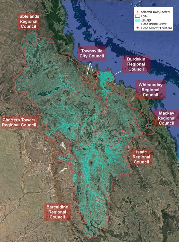
Document details
Security classification Public The Burdekin and Haughton Flood Resilience Strategy
Date of review of security classification June 2021 is a community-led approach and partnership between
Authority Queensland Reconstruction Authority
eight councils working towards a shared vision of flood
resilience for our region.
Document status Final
Version 1.0
Councils can assist you with up-to-date flood related
information including evacuation centre openings and
QRATF/21/748 (GD/0623)
QRA Reference
locations, river heights, road conditions and closures,
power and phone outages. Many councils provide an
Copyright online dashboard for disaster management or emergency
This publication is protected by the Copyright Act 1968. © The State of
Queensland (Queensland Reconstruction Authority), June 2021. management, including information about local hazards,
Licence key situational awareness information and other
This work is licensed by State of Queensland (Queensland Reconstruction Authority) under a Creative
Commons Attribution (CC BY) 4.0 International licence.
resilience initiatives.
To view a copy of this licence, visit www.creativecommons.org/licenses/by/4.0/ For emergencies, dial Triple Zero (000) for Police, Fire
In essence, you are free to copy, communicate and adapt this publication, as long as you attribute the
work to the State of Queensland (Queensland Reconstruction Authority). and Ambulance. For help with a damaged roof, rising
Interpreter flood water, trees fallen on buildings, or storm damage
The Queensland Government is committed to providing accessible services to use the SES app or phone 132 500. For information about
Queenslanders from all culturally and linguistically diverse backgrounds. If you have
difficulty in understanding this report, you can access the Translating and Interpreting emergency services and safety visit
Services via www.qld.gov.au/languages or by phoning 13 14 50. www.qld.gov.au/emergency.
Disclaimer
While every care has been taken in preparing this publication, the State of Queensland accepts no
responsibility for decisions or actions taken as a result of any data, information, statement or advice, Council/website Disaster Dashboard
expressed or implied, contained within.
To the best of our knowledge, the content was correct at the time of publishing.
Burdekin Shire Council
Copies
Copies of this publication are available on our website at: www.qra.qld.gov.au/burdekin-haughton
www.burdekin.qld.gov.au disaster.burdekin.qld.gov.au
Further copies are available upon request to:
Queensland Reconstruction Authority Charters Towers Regional Council
PO Box 15428 www.charterstowers.qld.gov.au www.getready.ctrc.qld.gov.au
City East QLD 4002
Phone (07) 3008 7200 Whitsunday Regional Council
info@qra.qld.gov.au
www.qra.qld.gov.au
www.whitsundayrc.qld.gov.au disaster.whitsundayrc.qld.gov.au
Isaac Regional Council
www.isaac.qld.gov.au dashboard.isaac.qld.gov.au
Barcaldine Regional Council
www.barcaldinerc.qld.gov.au
Townsville City Council
www.townsville.qld.gov.au disaster.townsville.qld.gov.au
Tablelands Regional Council
www.trc.qld.gov.au dashboard.trc.qld.gov.au
Mackay Regional Council
www.mackay.qld.gov.au disaster.mackay.qld.gov.au
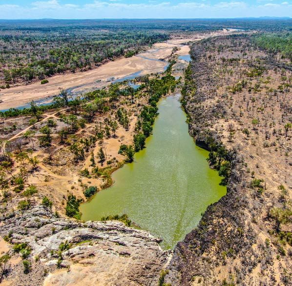
Images: (cover) Echo Hole on the Upper Burdekin courtesy of F. Ramsay, (this page) Mount Inkerman Scenic Lookout, (right) Bowling
Green Bay Ramsar wetland near Giru (courtesy of F. Ramsay).
To support Queensland communities in their recovery
following the North and Far North Queensland Monsoon
Trough disaster event from 25 January to 14 February 2019,
the $1 million Burdekin and Haughton Flood Resilience
Strategy project was approved as part of the $242 million
Disaster Recovery Funding Arrangements (DRFA)
Category C and D package jointly funded by the Australian
Government and the Queensland Government.

                                    Acknowledgement of Country
                                    We acknowledge the Traditional Owners
                                    and Custodians of this Country. We
                                    recognise and honour their ancient
                                    cultures, and their connection to land,
                                    sea and community. We pay our respect to
                                    them, their cultures, and to their Elders,
                                    past, present and emerging.

                                                                                 3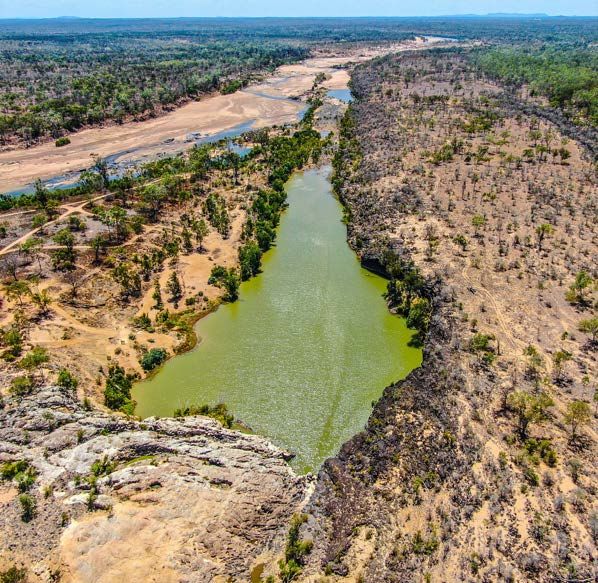
4 Burdekin and Haughton Flood Resilience Strategy
Foreword
In recent years, the Burdekin and Haughton River catchments have experienced repeated and severe flooding events that have impacted
on the livelihoods and properties of people who live and work in our region.
The Burdekin River is Australia’s largest river when at its peak discharge volume, and we rely on this water as the lifeblood of our
productive region.
Our communities accept flooding occurs naturally in Queensland, and we appreciate that understanding how our environment works is
intrinsically linked to our ability to thrive.
Our communities already have solid foundations in resilience, and our community-led approach to disaster resilience is part of life for
Central and North Queenslanders.
This Burdekin and Haughton Flood Resilience Strategy outlines how we will work together to proactively reduce flood risk and increase
resilience throughout the catchments.
We can better prepare for the future and keep our communities safe by coordinating efforts, sharing knowledge and capability, and
setting a proactive agenda for improving resilience over time across the catchments.
This Strategy is about reinforcing the shared responsibility of disaster resilience, and providing pathways to strengthen our capability and
capacity. It also identifies opportunities to boost our resilience efforts and actions to advance social, environmental and economic goals
for our communities, and our region more broadly.
By understanding the potential disaster risks we face, and working together to better manage our collective disaster risk, our region will
contribute to a stronger and more resilient Queensland.
The Strategy has been developed in partnership between the Australian and Queensland Governments, the local governments of the
Burdekin and Haughton River catchments, and a range of stakeholders with a valued connection to the region.
The following eight councils have collaborated to focus on how we will work towards our shared vision of flood resilience for the
Burdekin and Haughton River catchments:

  • Barcaldine Regional Council                     • Isaac Regional Council                          • Townsville City Council
  • Burdekin Shire Council                          • Mackay Regional Council                         • Whitsunday Regional Council.
  • Charters Towers Regional Council                • Tablelands Regional Council

Cr Lyn McLaughlin
Mayor, Burdekin Shire Council

Acknowledgements
The Queensland Government thanks the following councils, agencies and organisations for their contribution to this Strategy:
 • Barcaldine Regional Council                        • Department of Environment and Science             • SunWater
 • Burdekin Shire Council                             • Department of Transport and Main Roads            • Burdekin Water Futures
 • Charters Towers Regional Council                   • Department of State Development,                  • Energy Queensland
                                                        Infrastructure, Local Government and
 • Isaac Regional Council                                                                                 • Telstra
                                                        Planning
 • Mackay Regional Council                                                                                • Optus
                                                      • Department of Agriculture and Fisheries
 • Tablelands Regional Council                                                                            • Northern Drone Services
                                                      • Department of Resources
 • Townsville City Council                                                                                • NBN Co
                                                      • National Drought and North Queensland
 • Whitsunday Regional Council                          Flood Recovery Agency                             • Wilmar
 • Queensland Reconstruction Authority                • Great Barrier Reef Marine Park Authority          • James Cook University
 • Queensland Fire and Emergency Services             • NQ Dry Tropics NRM                                • Bureau of Meteorology

Image: The township of Giru in flood, 2018 (courtesy Burdekin Shire Council).
                                                                                                                                               5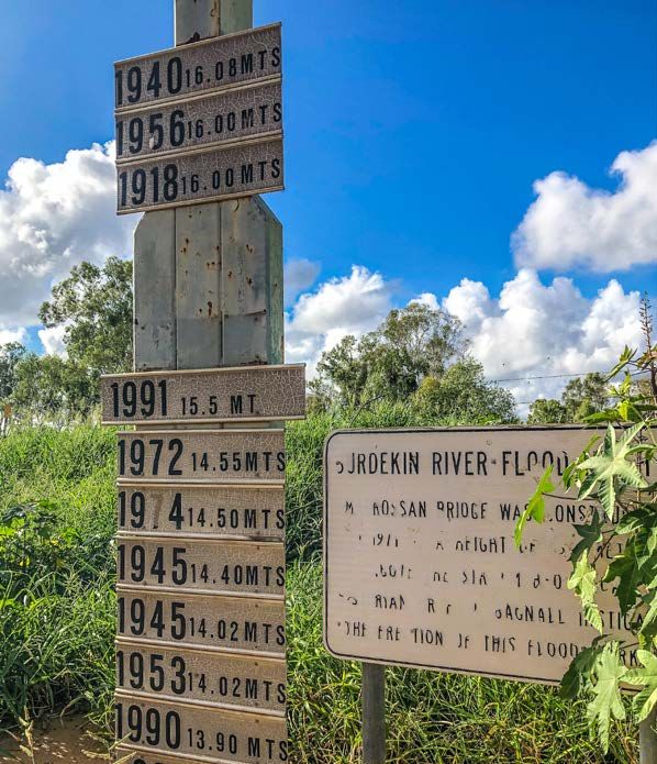
Contents
       Foreword5
       Acknowledgements                                                                                        5
       Our vision                                                                                              7
       Our community-led approach                                                                             8
       Our region                                                                                             9
       About this strategy                                                                                    11
       What is resilience?                                                                                    17
       Flood hazard characteristics                                                                           19
       Elements of resilience                                                                                 40
       How we prepare                                                                                         59
       Enhancing our community-led resilience                                                                 61
       A shared strategy                                                                                      62
       Regional strategic pathways                                                                            63
       Place-based community snapshots                                                                        64
       Strategy implementation                                                                                87

     Image (this page): Localised flooding in the upper Belyando near Alpha, 2020.
     (Opp page): Burdekin River historic flood marker at the Macrossan Bridge in the Charters Towers region.

6   Burdekin and Haughton Flood Resilience Strategy
Our vision
  We are a region of people who are proudly self-sufficient and self-reliant.
  We take care of our own, and are robust about dealing with flood events.
  We have a long history of flood exposure, it is part of living in North Queensland.
  Because of this, we are adaptive and know what to expect when the rain comes
  both now, and into the future.
  We acknowledge and embrace our diversity as a community, and revel in our
  shared values.
  We lend a hand to each other, and help newcomers to ‘learn the ropes’ about
  living with flood.
  As a community, we proudly lead our own resilience.

                                                                                        7
Our community-led approach
     During the wet season, there is no shortage of water flowing           The Burdekin and Haughton Flood Resilience Strategy (the strategy)
     through the Burdekin and Haughton catchments. While flooding           is our locally-led and regionally-coordinated blueprint, to leverage
     may bring with it a range of different impacts, water is a resource    the existing resilience of our communities. It unites our community-
     that is highly valued. Water supply underpins much of our region’s     led approach to flood resilience with innovative and coordinated
     social, economic and environmental prosperity.                         opportunities to further reduce our region’s flood risk and strengthen
                                                                            the resilience of our townships, economy, infrastructure and the
     Serious weather events can cause flooding, and cyclones, monsoon       environment.
     troughs and severe storms, are commonplace. Our exposure to
     flooding in the Burdekin and Haughton catchments has shaped
     our resilience over time. Both our capability and capacity to endure
     have been tested time and time again, and on each occasion, we
     rise to the challenge.

                Locally-led                            Regionally coordinated                            State facilitated

    Video: Find out more about the Burdekin and
    Haughton Flood Resilience Strategy by watching
    the videos at www.qra.qld.gov.au/burdekin-
    haughton.

     Image: Notes captured from ‘big map’ engagement activities during strategy development.

8   Burdekin and Haughton Flood Resilience Strategy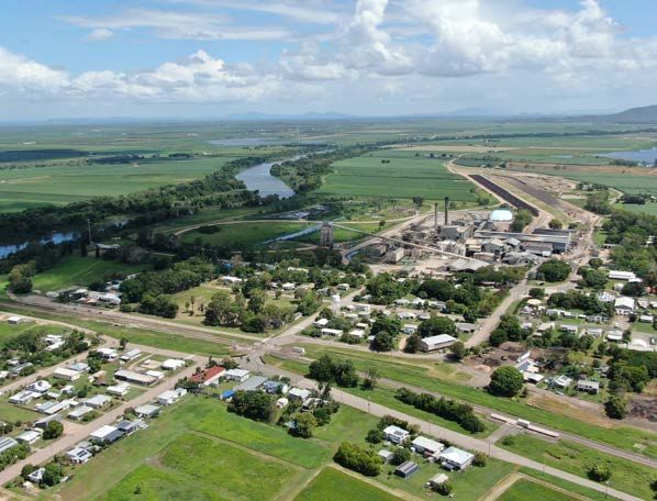
Our region
Local governments                                                      Our communities
There are eight local governments within the Burdekin and              The Burdekin and Haughton catchments stretch from south of
Haughton catchments. The six councils with a majority area             the town of Alpha, north to the Atherton Tablelands, west to the
contained within the catchment boundary are:                           Great Dividing Range, and east to the coast where the catchments
                                                                       discharge to the Great Barrier Reef coastal zone.
 • Burdekin Shire Council
                                                                       Our communities are diverse and unique. The population of the
 • Charters Towers Regional Council
                                                                       Burdekin and Haughton catchment area is approximately
 • Whitsunday Regional Council                                         111,360 people.
 • Isaac Regional Council                                              The fertile alluvial soils of the catchments support the rural and
 • Barcaldine Regional Council                                         agricultural land uses occupying much of the region. A rich mining
                                                                       history and strong community networks are maintained through
 • Townsville City Council.                                            townships and centres dotted across the landscape including
                                                                       Collinsville, Glenden, Charters Towers and Ravenswood.
Two councils with a partial area within the catchment are Tablelands
Regional Council and Mackay Regional Council.                          The major urban centres within the catchment are located at
                                                                       Charters Towers, Ayr, Home Hill and Collinsville. A small portion of
These eight councils are working together, to deliver shared
                                                                       the Townsville local government area forms part of the Haughton
solutions to common resilience challenges across the Burdekin and
                                                                       catchment.
Haughton catchments.
                                                                       In the Haughton catchment are the townships of Clare, Ayr,
                                                                       Brandon, Jerona and Giru, as well as Mingela and Woodstock,
                                                                       which are located toward the catchment’s headwaters. It should
                                                                       be acknowledged that while Ayr and Clare are technically located
                                                                       within the Barratta sub-catchment of the Haughton system, riverine
                                                                       flooding in both towns stems from the Burdekin River.
                                                                       The Burdekin and Haughton catchments comprise a series of
                                                                       sub-catchments, these include:

                                                                        • Belyando
                                                                        • Suttor
                                                                        • Cape and Campaspe
                                                                        • Upper Burdekin
                                                                        • Bowen (including the Broken and Bogie)
                                                                        • Lower Burdekin
                                                                        • Haughton
                                                                        • Barratta Creek.

Image: View across Charters Towers from Tower Hill.

                                                                                                                                              9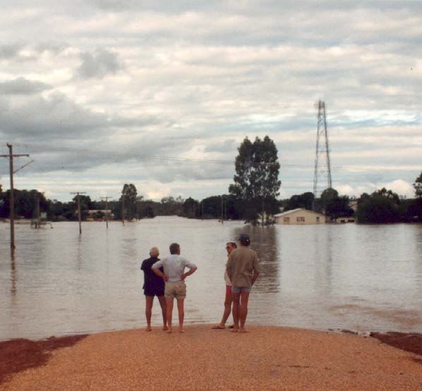
The Burdekin and Haughton catchment

                                                       Legend
                                                          Towns
                                                          Rivers
                                                          Burdekin-Haughton Basin
                                                          Local Government Areas

10   Burdekin and Haughton Flood Resilience Strategy
About this strategy
Objectives for flood resilience Recognising our own resilience
The purpose of this strategy is to achieve the following objectives: This strategy seeks to guide how we will proactively work together
to enhance flood-related disaster resilience over time. It combines
• recognise and encourage the behaviours, mindsets and strategy and investment in resilience action in a way that
activities that contribute toward flood resilience encompasses the impacts of our weather and climatic conditions
• adopt whole-of-catchment approaches that deliver shared across the Burdekin and Haughton catchments.
solutions to common problems
This strategy adopts a holistic view of the factors that underpin and
• understand how the nature of localised flood risk intersects with contribute to flood resilience, with regard to the multitude of ways
regionally relevant resilience goals we are exposed to flood-related impacts across the region, and the
various ways in which we can collectively address our risks.
• work cohesively toward common catchment or regional
resilience goals Central to this is recognising the role and value of water for the
• combine strategy with long-term investment to support environment and our livelihoods. Flooding is a natural process we
continued community-focused resilience. have duly shaped our lives and behaviours around.
While the coordination of disaster resilience action is a key
aspiration of this strategy, it must also be recognised that no two
“This is about being on the front foot places or communities are the same – especially in a catchment
with an area equivalent to the size of Tasmania.
with resilience... so when we do have
another event, we are actually better
prepared.” From time to time, as much as the river
Mayor Andrew Wilcox, Whitsunday Regional Council
system gives, it also takes away.
Diagram: disaster risk reduction.
Grassroots Resilient
Disaster risk reduction
community-led action communities
Image: A swollen Belyando River on the Capricorn Highway, 2020.
11A systems-based approach
Some aspects of resilience are relatively straightforward in terms of This approach also integrates a trans-disciplinary approach, which
the opportunities for enhancement. Other aspects of resilience can brings science, research, social science, governance and policy
be complex and deeply entrenched in systemic issues. together with local knowledge.
Integrated floodplain management involves a multidisciplinary These approaches culminate in an Action Plan which supports
approach across a range of sectors engaging in disaster the implementation of this strategy, providing a blueprint for
management, engineering, land-use planning, community and project delivery to support enhanced flood resilience, led by local
economic development, transport, environmental management government.
and communications. This approach contributes to an overarching,
shared evidence base of knowledge with the capacity to explore
systemic issues.
Diagram: Integrated catchment planning approch (source: QRA).
12 Burdekin and Haughton Flood Resilience StrategyHow this strategy connects
This strategy represents a local approach to resilience building and forms part of a broader strategic landscape at the State, national and
international levels that guides how we will collectively achieve our resilience goals with a focus on disaster risk reduction and sustainable
development.
Diagram: Disaster resilience policy line of sight.
National and Sendai Disaster Risk
National Strategy for National Disaster Risk
Reduction Framework and
International Disaster Resilience Reduction Framework
Ulanbaatar Declaration
Disaster resilience Functional economies and
policy line of sight connected communities
Queensland Strategy Other State level
for Disaster Resilience programs / policies
State
QSDR objectives in place
Climate change
Resilient Queensland
and vulnerability/risk
2018-2021
(QERMF)
Regional economic,
Regional Resilience
Regional land use, natural resource
Strategies
and transport plans
Local directions
Local and actions
Other local plans
13Integrating programs and projects Resilient Queensland – delivering on the
Queensland Strategy for Disaster Resilience
This strategy combines and builds upon a range of local and regional
The Queensland Government is focused on strengthening disaster
strategic documents to articulate the various aspects of resilience
resilience so that communities are better equipped to deal with the
action identified across the Burdekin and Haughton catchments. The
increasing prevalence of disaster events.
following outlines some of the key plans, projects and studies that
have been drawn upon to inform this strategy. A key outcome of Resilient Queensland is the development of
regional resilience strategies that will support the coordination and
National Disaster Risk Reduction Framework prioritisation of future resilience-building and mitigation projects
The National Disaster Risk Reduction Framework (NDRRF) is a multi- across Queensland.
sector collaboration led by the National Resilience Taskforce within
the Australian Government Department of Home Affairs. The NDRRF By 2022, every local government in Queensland will be part of a
was co-designed with representatives from all levels of government, regional resilience strategy that clearly identifies and prioritises
and business and community sectors. Over 100 participants from actions to strengthen disaster resilience over time.
more than 80 diverse organisations came together at a three-day
A community-led catchment is one of the first five regional resilience
intensive ‘policy sprint’ to develop key components of the NDRRF.
strategies prepared as part of Resilient Queensland. The strategy
The NDRRF outlines a coordinated approach to reducing disaster seeks to identify and address locally derived challenges that may be
risk, which is a critical component of enabling resilience. It is shared across local government jurisdictions.
designed to leverage the great work and progress made across all
As the most disaster-impacted state in Australia, it is critical we
sectors since the 2011 release of the National Strategy for Disaster
harness best practice and look for new ways to work together to
Resilience, and to better understand and reduce disaster risks,
improve the resilience of communities across Queensland, adopting
improve resilience, and bolster the capability and capacity of
pathways toward a safer, stronger and more resilient Queensland.
communities to withstand natural hazards.
More than ever, limiting the impact of disasters now and in the North Queensland Regional Plan
future requires a coordinated effort across and within many The North Queensland Regional Plan was released in 2020 and
areas, including land-use planning, infrastructure, emergency is a 25-year strategic statutory planning document for the local
management, social policy, agriculture, education, health, government areas of Burdekin, Charters Towers, Hinchinbrook,
community development, energy and the environment. Palm Island and Townsville.
It has been prepared to support the established and emerging
industries in the region, and to address changes expected to occur
within the region. These changes include a growing and ageing
population, shifting economic and employment patterns, impacts
from climate change and continued technological advances.
The principal aim of the regional plan is to determine how land-use
and infrastructure planning can best support economic growth and
population change in the region over the next 25 years and beyond.
This will be achieved by enhancing the social, economic and
environmental systems that support the region’s liveability.
Image: Passenger train crossing the Burdekin Bridge.
14 Burdekin and Haughton Flood Resilience StrategyMackay, Isaac and Whitsunday Regional Plan Queensland Climate Adaptation Strategy
The Mackay, Isaac and Whitsunday Regional Plan establishes a The Queensland Climate Adaptation Strategy 2017–2030 outlines
vision and direction for the region to 2031. It provides certainty about how Queensland will collectively prepare for current and future
where the region is heading and provides a framework to respond to impacts of a changing climate to reduce risk and increase resilience.
challenges and opportunities that may arise. This strategy recognises Queensland is already experiencing hotter
summers, more frequent natural disasters and more impacts on our
The regional plan aims to respond to the variety of distinct natural environment, and that these changes pose a threat to our
challenges facing the region to 2031, having regard to cycles of economy, our communities, our environment and our way of life.
the resources sector, growth and contraction, and the need to
sustainably manage development and resources. The regional The strategy, along with specific sector-based adaptation plans,
plan also seeks to plan effectively for essential infrastructure outlines our commitments and the actions we will take to transition
services, such as transport, community and social services. It further to a low carbon, clean growth economy, and adapt to the impacts of
recognises the need to prepare for, and appropriately respond to, a changing climate.
the anticipated impacts of climate change.
Sector adaptation plans are an important component of the
Regional Transport Plans strategy. These eight plans help to prioritise climate change
The Northern Queensland, Mackay, Isaac and Whitsunday, and adaptation activities across the key sectors of the community. They
Central West Regional Transport Plans (RTPs) seek to prioritise and have been developed in consultation with sector and industry
manage their respective transport systems so that they effectively stakeholders to reflect the needs and priorities of each sector. They
support regional communities, growth and productivity. identify emerging opportunities, share knowledge and encourage
collaboration. The sector adaptation plans focus on:
The plans seek to establish common transport priorities between the
Queensland Government and local governments, communicating • small and medium enterprise
the planning intent for the regions. They also define the transport • biodiversity and ecosystems
systems’ role in achieving regional goals and priorities for forward
planning and investment, in partnership with local government. • human health and wellbeing
• emergency management
Improved flood resilience is identified as a key priority and objective
for each of these RTPs. Underpinning this, each RTP includes a • agriculture
number planning actions to improve flood resilience through
better planning of infrastructure, collaboration and intelligent • built environment and infrastructure
transportation systems (ITS). • tourism.
• industry and resources.
Image: The Upper Burdekin sub-catchment.
15Queensland State Natural Hazard Risk Local government and industry documents
Assessment 2017 A range of local government plans, strategies and studies have
Prepared by Queensland Fire and Emergency Services, the State also been used to inform this strategy. This includes local disaster
Natural Hazard Risk Assessment provides a state-wide analysis of management plans, planning schemes, community and economic
relevant natural hazard risks, including tropical cyclones, severe development plans, and coastal hazard adaptation strategies
storms, flooding, coastal hazards, heatwaves, bushfires and among others. This is in addition to a series of industry-based
earthquakes. The assessment considers the nature of natural documents and content prepared by relevant not-for-profit
hazards relevant to Queensland, as well as elements of likelihood, organisations and non-government organisations with a presence in
consequence, exposure and vulnerability to understand both the Burdekin and Haughton region.
inherent and mitigated risk profiles. The assessment links to the
Queensland Emergency Risk Management Framework (QERMF), Queensland Floods Commission of Inquiry
which provides a comprehensive and systematic approach to The Commission of Inquiry was established by the Premier of
informing risk-based planning across Queensland. Queensland in response to the 2010–2011 flood events. The
Commission of Inquiry conducted a comprehensive review, focusing
Queensland Emergency Risk Management on areas such as preparation and planning, adequacy of response,
Framework adequacy of forecasts and early warning systems, and land-use
The Queensland Emergency Risk Management Framework (QERMF) planning in the lead up to the 2010–2011 floods.
has been developed to inform risk-based planning across the
The final report included recommendations across a vast range of
emergency management sector in Queensland. The application
technical and governance disciplines highlighting the complexity
of the QERMF promotes opportunities for collaboration and
of flood risk management in Queensland. Included in the
communication between government, industry stakeholders and
recommendations was the need to conduct additional flood studies
the community across the three disaster management levels (local,
and undertake further consultation with local governments to
district and state) in Queensland. It also promotes the need for
enhance the cooperative approach to flood risk management.
identification and communication of residual risk across these
levels.
The QERMF assists key stakeholders working within Queensland's
Disaster Management Arrangements (QDMA) to review existing
natural disaster risk management processes and assist in enhancing
resilience, as outlined within the Queensland Strategy for Disaster
Resilience.
Initial stages of the QERMF process have been used to develop this
strategy, ensuring that it is appropriately risk-informed and aligned
to the QDMA.
Image: A view over Burdekin Shire from Mt Inkerman.
16 Burdekin and Haughton Flood Resilience StrategyWhat is resilience?
Resilience can mean many things, including the ability to bounce
back or withstand a disaster event, and continue to move forward.
The term ‘resilience’ can often take on a very personal meaning, and
can be characterised by a range of unique attributes.
When an emergency, disaster or trauma event occurs, there are
many different ways in which resilient behaviours and processes
can play out. The following sections consider the varying aspects of
resilience, and how we all have a role to play.
Elements of resilience
The multi-dimensional and cross-disciplinary approach of this strategy contemplates five elements that contribute to systems-based resilience.
These are:
Human and social
Economy Towns and
Infrastructure
Community
resilience
Roads and
Environment
Transport
Image: Historic flood marker information at Alpha.
17Community resilience Business resilience
The attributes underpinning community resilience are slightly The businesses in our region, both small and large, are critical to the
different in nature to those characterising resilience in individuals. continuity of community functions before, during and after a flood
event. The provision of ongoing services and employment, no matter
Resilient communities are embodied by the collective behaviours the scale, makes a difference to broader community resilience.
and mindsets of individuals and households, which focus on
connections with others for support and capacity before, during and It is for this reason that business continuity planning for small,
after trying times. Resilient communities also tend to be adaptable medium and large enterprises in the Burdekin and Haughton region
to changing circumstances, stewarded by strong community is central to the resilience of communities. In addition, the ability to
leadership. They are also diverse and enterprising, and maintain a continue operating minimises disruption to business and cashflow.
strong sense of identity and belonging. This can be essential for business owners, managers and
employees who are impacted by events and seek to maintain
Household and individual gainful employment and continue to be productive members of the
resilience community during difficult times.
At the household and individual level, resilience can be
characterised by a sense of resourcefulness, open-mindedness, and
self-reliance or self-sufficiency.
One’s awareness of risk and its realities is also paramount. Ingenuity,
capability and capacity to accept challenges and seek to overcome Business continuity
them is a common trait. This is supported by a strong set of values
and a desire to connect with and support others. These attributes
stand a person in good stead to overcome and adapt to life's
challenges.
Being prepared and having a plan for severe weather and its
impacts increase our ability to exercise resilience. Community
However, there is a difference between stoicism and resilience. continuity
Looking after ourselves, our mental and physical wellbeing and that
of others around us is critical. Continued
Critical
provision of
infrastructure
essential
operations
services
18 Burdekin and Haughton Flood Resilience StrategyFlood hazard characteristics
How catchments work
Almost every season, somewhere in Queensland will experience Especially in Queensland, the disaster season is that period of the
heavy rainfall that can lead to flash flooding and riverine flooding. year where we can experience all types of natural hazard events, and
This is due to our climate and can be driven by monsoon troughs, this is changing as a result of climate-related considerations. This
east coast low events and cyclones. means we might experience a bushfire event one week and a major
flood the next. Where our landscape is degraded, either by fire,
Where rainfall goes depends upon topography. River catchments drought or poor land management practices, flooding rains can lead
are defined by elevated areas, known as the headwaters, at the to landslips and extensive landscape and riverine erosion.
top of the catchment. Catchments generally comprise a number of
tributaries that catch and convey rainfall into our river systems. Catchment contamination, erosion, sedimentation, increased
nutrient loads and silting are particular challenges for the
Catchments are not just relevant in terms of flooding and floodwater, environmental quality of our rivers, and the fauna and flora they
but can be important to consider in relation to other natural hazards support. This can also impact on the quality of water supplies on
such as bushfires and landslides. The inter-linkages between which our communities and economies depend.
different hazards are highly evident at the landscape scale. For
example, in some cases, bushfire events can burn very hot, Understanding how our catchments work is vitally important, as
stripping vegetation and damaging soils across vast areas. Degraded they can be subject to impacts from a wide range of natural hazards
landscapes can also occur after years of persistent drought. beyond just flooding.
Video: The video at www.qra.qld.gov.au/
burdekin-haughton includes a 3D model to
help explain how the Burdekin and Haughton
catchments work.
Image: Historic flooding in the township of Alpha.
19LAKE DALRYMPLE
COLLINSVILLE
AYR
ALPHA
HOME HILL
EUNGELLA
GIRU
GLENDEN
Alpha Creek
Mistake Creek Belyando River
Cape River
Suttor River
Haughton River
Lake Eungella
Broken River Bowen River
Lower Burdekin
Bogie River
Barratta Creek
The landscape
The Burdekin catchment occupies a significant portion of the state, The Burdekin catchment comprises several sub-catchments, with
stretching from the south of Alpha in Central Queensland, to the the Burdekin River said to be ‘the centrepiece to an entire network
Atherton Tablelands in the north, from the Great Dividing Range of rivers’. It is estimated that on average, approximately 50 per cent
in the west and out to the coast, east of Home Hill. The Haughton, of the water discharged from the mouth of the Burdekin River is
which adjoins the Burdekin to the north, finds its headwaters in the derived from the Upper Burdekin sub-catchment alone.
area of Mingela (part of Hervey Range), flowing east to the coast,
past Giru.
20 Burdekin and Haughton Flood Resilience StrategyCHARTERS TOWERS
GREENVALE
Hann Creek
Campaspe River
Lolworth Creek
Gray Creek
Basalt River Clarke River
Dry River
Fanning River Star River Upper Burdekin
Keelbottom Creek
From the south, the Belyando sub-catchment comprises Alpha Creek The Suttor River flows from the Denham and Leichardt Ranges east
and Native Companion Creek, which merge into the Belyando River of Glenden in a westerly direction, before joining with the Belyando
to the north of the township of Alpha. The Belyando River originates River to the north of Belyando Crossing. The Suttor River then
on the western slopes of the Drummond Range, located in the continues to flow north for approximately 100 kilometres before
southern reaches of the catchment in Central Queensland. discharging into Lake Dalrymple (Burdekin Falls Dam). Over half of
The Belyando flows north about 350 kilometres to join the Suttor the Suttor sub-catchment is made up of floodplains and lowlands.
sub-catchment.
This general area of the region maintains similar characteristics
to that of the headwaters of the channel country of the Lake Eyre
Basin, with both located within this Desert Uplands Bioregion of
Queensland.
21Lake Dalrymple is where three of the upper sub-catchments Downstream from Millaroo, the Bogie River system meets the Lower
converge within the Burdekin system. This includes the Suttor (and Burdekin, which flows from the inland area to the west of Bowen for
Belyando), the Cape and Campaspe, and the Upper Burdekin sub- approximately 120 kilometres.
catchments.
From its juncture with the Bogie River, the mighty Burdekin River
The Cape and Campaspe sub-catchment finds it headwaters in the continues for a further 80 kilometres, sprawling into a large coastal
Great Dividing Range to the north of the Flinders Highway, flowing in delta, and through the main mouth of the river approximately 25
a generally south-easterly direction to meet Lake Dalrymple. kilometres east of Ayr. The coastal delta comprises many drainage
outlets, which discharge to the Great Barrier Reef coastal zone.
The Upper Burdekin flows south from the Seaview and Gorge
Ranges to the north-east of Lake Lucy and the Valley of Lagoons. Flanking the northern side of the Lower Burdekin sub-catchment is
It journeys south where it is joined by a number of major creek the Haughton River system, which also includes the Barratta sub-
and river systems from the east and west before transitioning into catchment. The Haughton systems flows east from Mingela (part of
the Lower Burdekin sub-catchment in the general vicinity of the Hervey Range), through Giru, before also discharging to the Great
Macrossan Bridge at Sellheim. The river continues to flow south for a Barrier Reef coastal zone. The Barrattas are a series of channels
further 120 kilometres into the northern area of Lake Dalrymple. forming part of the Haughton catchment, running almost parallel
with the Haughton River before discharging to the coast east of
This river system, along with the Douglas, Dry, Running and Star Jerona.
Rivers and Oaky and Camel Creeks, drain the northern extremities
of the catchment to the west of the Seaview, Gorge and Paluma Receiving waters of the Burdekin and Haughton catchments include:
Ranges. Allingham, Hann, Lion, Fletcher and Lolworth Creeks and
Basalt River drain the catchment from the western extremities, • the internationally significant Bowling Green Bay Ramsar site
flowing east to the Burdekin River. The Fanning and Kirk Rivers are • important declared fish habitat areas at Cleveland Bay and
the last major tributaries flowing into the Upper Burdekin sub- Bowling Green Bay
catchment, joining near Sellheim.
• Cleveland, Bowling Green and Upstart Bay dugong protected
Lake Dalrymple is formed by the Burdekin Falls Dam, which was areas
constructed in the 1980s and is the largest body of fresh water in
• the State Great Barrier Reef Coast Marine Park
Queensland. Located 159 kilometres upstream from the mouth
of the Burdekin River, the dam was constructed to support water • the Great Barrier Reef lagoon, which is World Heritage-Listed
supply and irrigation in the region, servicing an irrigation area and a marine park.
of approximately 100,000 hectares downstream. The dam wall
measures 876 metres in width, with a spillway of 504 metres.
That portion of the Lower Burdekin that is downstream from the “None of us operate in isolation. A
dam drains the western slopes of the Clarke Range, approximately flood event at the back of Ingham
70 kilometres inland from Mackay.
affects Charters Towers and the
Discharging into the Lower Burdekin sub-catchment, below the dam, Burdekin Shire. We all have to work
is the Bowen system, which is bound by the Denham, Leichardt and
Clarke Ranges. This system has a major impact on the hydrology as one with these flood situations and
and water movement of the Lower Burdekin sub-catchment. The other disasters in order to get better
headwaters of the Bowen sub-catchment start at the Broken River
in the Mackay region, flowing over 200 kilometres north through the
outcomes.”
Eungella hinterland before becoming the Bowen River. The Bowen Mayor Frank Beveridge, Charters Towers Regional Council.
River enters the Lower Burdekin upstream from Dalbeg.
Image: Flows in the Bowen River (courtesy Whitsunday Regional Council).
22 Burdekin and Haughton Flood Resilience StrategyA snapshot of catchment characteristics
catchment size of 134,159
square kilometres
Lake Dalrymple holds 4 times the
volume of water of Sydney Harbour
X4
the Burdekin catchment drains
7 per cent of the land mass of
7% Queensland
the Burdekin is the largest river
in Queensland by flow volume
the Burdekin River flows over 710
kilometres and is the centrepiece of
a series of waterways
the Haughton catchment is known
as one of the most flood prone in
Queensland
23Catchment stories Rainfall
This strategy is supplemented by a separate body of work, led by the The Dry Tropics region usually experiences annual wet and dry
Department of Environment and Science involving the ‘Walking the seasons, with most of the rainfall typically between November and
Landscape’ process and the development of a catchment story. March. The Burdekin River typically flows for a short period of the
year (WetlandInfo, 2018).
Through this processes, particpants work systematically through
catchments in facilitated workshops during which knowledge of Rainfall across the catchments is highly variable, due to the sheer
landscape features and processes are gathered to develop a whole- scale of the area ranging from Desert Uplands to the Wet Tropics
of-landscape understanding of how water flows in catchments. The Bioregion. For example, average annual rainfall in the Haughton
information gained is used to inform the development of catchment catchment region is approximately 953 millimetres, but can range
stories. between 550 to 3200 millimetres per year. In the Belyando sub-
catchment, the average annual rainfall is closer to 500 millimetres
Catchment stories describe the location, extent and values of (WetlandInfo, 2018).
catchments as well as demonstrating the key features, which
influence water flow, including geology, topography, rainfall and This variability is linked to the El Nino Southern Oscillation and the
run-off, natural features, human modifications and land uses. Map formation of tropical low pressure systems, sometimes referred to as
journals and videos form the basis of catchment stories providing a monsoon trough. Additionally, cyclones generated by low pressure
mechanisms for integrating spatial information, photographs systems and warm oceans can contribute significant volumes of
and animations with an informative narrative to demonstrate the rainfall on land (Dry Tropics NRM, 2016).
features of catchments. Catchment stories are valuable tools that
can be used to improve evidence-based decision-making for the The Eungella area to the west of Mackay is a very high rainfall area,
sustainable management and restoration of ecological systems. with steep gradients and hard geology, which has a major influence
on the flows of the Broken and Bowen Rivers, and can lead to
Catchment stories for parts of the Burdekin and Haughton region, significant flooding through the Lower Burdekin.
produced by the Department of Environment and Science, can be
viewed at www.wetlandinfo.des.qld.gov.au. The region’s coastal areas are characterised by a tropical sub-humid
climate, with relatively high temperatures all year round and heavier
rainfall and associated higher humidity in the summer months.
Higher altitude coastal ranges, particularly in the region’s north
and south, have a wet tropical climate with cooler temperatures,
and rainfall is distributed more broadly across seasons. In contrast,
rainfall gets progressively lower towards the west and is more
variable compared to the coastal areas. The dry seasons are longer
and cooler, and the wet seasons hotter and more unpredictable in
these semi-arid inland areas (Dry Tropics NRM, 2016).
Image: The Upper Burdekin sub-catchment.
24 Burdekin and Haughton Flood Resilience StrategyClimate change
While climate varies naturally on timescales, from millions of years Under a scenario where greenhouse gas emissions stabilise by
to year-to-year, since the advent of the industrial age there has been 2060, the following projections for the Burdekin and Haughton
a rapid increase in temperatures, and in the variability of weather catchments are identified:
events (Dry Tropics NRM, 2016).
• average mean climate of the catchment areas is predicted to
The CSIRO’s Monsoon North East technical report on climate change increase by between 1.8 and 2 degrees Celsius by 2090, and
in Australia identified average temperature rises in the Monsoonal this is expected to be higher for inland areas, including the
North region (in which the Burdekin Dry Tropics region is situated) Barcaldine region
of between 0.9 and 1.0 degrees Celsius since 1910, and predicts
• average heatwave temperatures are predicted to increase
further increases of greater than 1.3 degrees Celsius by the end of
by between 1.3 and 1.6 degrees Celsius by 2090 across the
the century (CSIRO, 2015 and Dry Tropics NRM, 2016).
catchments, with Burdekin Shire projected to increase by 1.8
General project catchment-scale changes due to climate change degrees Celsius
during the next century include: • average extreme temperature days across the catchment areas
are predicted to increase by 37 days by 2090
• decreasing water resource quantity and quality
• average extreme precipitation in the catchment areas is
• decreasing plant and crop growth
predicted to decrease by -3.7 mm by 2090
• increasing intensity of rainfall events
• average drought months across the Burdekin and Haughton
• increasing intensity and frequency of bushfire region are predicted to increase by 1.4 months by 2090
• increasing intensity of cyclones, but unlikely increase in • ‘wetness’ in Queensland is usually associated with specific
frequency drivers such as La Niña years, and extreme events, for example,
convective storms, low pressure systems and tropical cyclones,
• increasing temperatures and heatwaves
with average wetness for the catchment areas predicted to
• increasing sea level and height of coastal hazard impacts decrease by -0.65 months by 2090.
• increased evaporation (CSIRO, 2015). The above is consistent with the general projections of similar
or possibly decreased rainfall events into the future, but with
The Queensland Future Climate Dashboard at www.wetlandinfo.
potentially increased intensity when they do occur. For further data
des.qld.gov.au summarises 11 state-of-the-art climate models with
and information, the Queensland Climate Futures Dashboard can
regional-scale simulations through to 2100. These models are varied
be accessed at www.longpaddock.qld.gov.au/qld-future-climate/
to consider different magnitudes of climate mitigation, including
dashboard/.
with limited action to mitigate greenhouse gas emissions, as well as
a scenario based upon the stabilisation
of greenhouse gas emissions.
Image: Downstream of Burdekin Falls Dam
(courtesy F. Ramsay).
25Weather systems that cause flooding
In any year in Northern Australia, it is likely that a significant rainfall event will occur, but not all major floods lead to disastrous
consequences. It must be remembered that, for many parts of Queensland, flooding brings significant benefits.
Major flooding in the Burdekin and Haughton catchments is often caused by monsoon rains, monsoon troughs, east coast low events and
tropical cyclones during the monsoonal wet season. Multiple large weather events have occurred in more recent years.
1990 Alpha Creek Belyando
River Rainfall Event
Severe Tropical 1990
Cyclone Joy
1998 Ex Tropical Cyclone Sid
Tropical Cyclone 2000
Tessi
2007 Monsoon Trough
Haughton River 2008
Rainfall Event
2009 Monsoon Trough
Tropical Cyclone 2010
Olga
2011 Tropical Cyclone Yasi
Ex Tropical 2013
Cyclone Oswald
2014 Tropical Cyclone Ita
Severe Tropical 2017
Cyclone Debbie
2019 Monsoon Trough
Image: Storm clouds over Burdekin Shire (courtesy Burdekin Shire Council).
26 Burdekin and Haughton Flood Resilience StrategyTropical cyclones Monsoonal rains and monsoon troughs
Tropical cyclones are low pressure systems that form over warm The Australian monsoon develops in response to summertime
tropical waters with sustained winds of 63 kilometres per hour heating over the northern Australian region, when the continent
or greater, and gale force winds with wind gusts in excess of 90 warms at a faster rate than the surrounding oceans. This sets up a
kilometres per hour near the centre. In the most severe cyclones, giant sea breeze circulation, drawing in moisture from these oceans
gusts can exceed 280 kilometres per hour. over the lower pressure on the land. As the humidity progressively
builds, a monsoon trough becomes established over the Australian
The Burdekin region has felt the impact of tropical cyclones on region. True monsoonal flow, with deep low-level westerly winds,
numerous occasions. The Bureau of Meteorology’s (BoM) Southern exists north of the trough, so when the trough moves south over a
Hemisphere Tropical Cyclone Data Portal shows 40 cyclones tracking location, this area becomes affected by monsoonal conditions
within 200 kilometres of the Townsville tracking station between the (BoM, 2012).
1969–1970 and 2017–2018 cyclone seasons. Tropical cyclones in the
Burdekin and Haughton catchments often result in extensive rainfall, Farmers and graziers, communities and the ecosystems that have
which can lead to major flooding. Previous cyclone events have evolved across Australia's north depend on monsoonal rains to
caused flooding for parts of the Charters Towers and Isaac regions replenish water storages and recharge natural aquifers. However,
and as such, must not be discounted in inland areas. these rains can also create substantial flooding and restrict
movement across large areas (BoM, 2012).
As well as extreme winds, a tropical cyclone can cause the sea to rise
well above the highest tide levels of the year when it comes ashore. Climate factors such as El Niño, La Niña and the Madden-Julian
Oscillation can be important influences on the timing and intensity
These storm surges are caused mainly by strong, onshore winds and of monsoon phases.
reduced atmospheric pressure. Storm surge is potentially the most
dangerous hazard associated with a tropical cyclone. Severe storms
Storm surge is an abnormal rise in sea level over and above the BoM defines a severe storm as a thunderstorm that produces:
normal (astronomical) tide levels. It can be thought of as the change
• large hail (two centimetres in diameter or greater)
in the water level due to the presence of a storm. These powerful
ocean movements are caused by strong winds piling water up • damaging wind gusts (90 kilometres per hour or greater)
against the coast as a tropical cyclone approaches.
• tornadoes
Storm tides can swamp low-lying areas, sometimes for kilometres
• heavy rainfall conducive to localised and/or flash flooding.
inland. Strong winds at the coast can also create large waves,
worsening the impact and giving rise to coastal erosion. Storm Thunderstorms are associated with a very tall cloud mass called a
surges are at their most dangerous when they arrive at high tide – cumulonimbus cloud, and usually develop when warm, humid air
when the sea is already at its high point. The resulting storm tide can carrying a lot of water vapour near the ground is forced upwards
flood inland areas. due to surface winds converging with an approaching front or low
pressure trough to make the moist air rise rapidly in an unstable
For further information, refer to the Queensland Fire and Emergency atmosphere.
Services Queensland State Natural Hazard Risk Assessment and
Burdekin Shire Council’s Coastal Hazard Adaptation Strategy, both Thunderstorms can become severe when the atmosphere is
available online. particularly unstable and/or additional energy is drawn in from
surrounding winds. Spring and summer seasons in Queensland are
particularly known for the rapid onset of severe storms, super cells
and downbursts.
A key example of this was the February 2020 localised rainfall event
over parts of the Burdekin Shire, which saw over 500 mm of rain fall
in just over 24 hours. Water levels quickly rose in Ayr, and the Bruce
Highway was closed between Ayr and Home Hill, in addition to local
roads. Rita Island received 615 mm of rain in the same period, which
isolated residents. The rainfall event was driven by a slow-moving
tropical low sitting over the waters of the Gulf of Carpentaria.
Image: Flooding of Plantation Creek across the Bruce Highway at Ayr
(courtesy Burdekin Shire Council).
27Flood warning system Flood classifications
The flood warning system in the Burdekin and Haughton catchments As part of the effective implementation of the flood warning system,
is made up of four elements: BoM uses a three-tiered classification scheme that defines flooding
as minor, moderate or major at key river height stations, known as
• 150 gauge assets like rainfall and river gauges in the Burdekin the river gauge locations. Each classification is defined by the water
system, and 32 in the Haughton system level that causes certain impacts upstream and downstream of the
• additional supporting infrastructure like flood cameras, ‘flooded station. These levels have been determined and described based
road’ signage, data transmission and power supply on standard descriptions of flood effects (see below), historical data
and relevant local information.
• flood prediction services, including eight flood forecast
locations on the Burdekin system and one on the Haughton This helps to inform communities to understand their risk, and
system provides triggers for action to prepare for flooding.
• communications/messaging processes (see flood Minor flooding
classifications information below).
Causes inconvenience. Low-lying areas next to watercourses are
Each of these elements need to function properly before, during inundated. Minor roads may be closed and low-level bridges
and following a flood event in order for people to fully understand submerged. In urban areas, inundation may affect some backyards
their exposure to the flood risk. An optimised infrastructure network and buildings below the floor level, as well as bicycle and pedestrian
(i.e. the gauges and the supporting infrastructure) is the backbone paths. In rural areas, removal of stock and equipment may be
of ensuring the right people have the right flood information at the required.
right time.
Moderate flooding
BoM notes that flood warning is an integral component of counter In addition to minor flood effects, the area of inundation is more
disaster arrangements for a community at risk from flooding. The substantial. Main traffic routes may be affected. Some buildings may
aim of the warning system is to minimise loss of life and property experience water above the floor level. Evacuation of flood-affected
damage by warning people in a timely way of the likelihood, size areas may be required. In rural areas, removal of stock is required.
and duration of a flood so that they may take the necessary actions
to mitigate any adverse consequences to the event. Examples would Major flooding
be to evacuate to a safer location, or relocate property or stock to In addition to moderate flood effects, extensive rural areas and/or
higher ground. urban areas are inundated. Many buildings may be affected above
Warnings are of limited value unless they are delivered in a timely the floor level. Properties and towns are likely to be isolated and
and effective manner, and property owners and residents in the major rail and traffic routes closed. Evacuation of flood-affected
flood-threatened area heed the warning and take appropriate action areas may be required. Utility services may be impacted.
in advance of being flooded.
Flood forecasting
There are eight forecast locations in the Burdekin system and one in
the Haughton system.
A forecast location is a location for which BoM provides a forecast
of a future water level, either as the class of flood that is predicted
(minor, moderate or major), or as a level and class (e.g. ‘4.6 metres –
major flood level’).
The Burdekin forecast locations are Alpha, St Anns, Taemas,
Sellheim, Burdekin Falls Dam, Dalbeg, Clare and Inkerman Bridge.
The Haughton forecast location is at Giru.
Image: Automatic flood warning gauge at the Burdekin Bridge.
28 Burdekin and Haughton Flood Resilience StrategyFlood Forecast Locations
29Flood behaviour and history
Burdekin catchment
The Burdekin River catchment is capable of producing major At the Taemas gauge on the Cape River, downstream of its junction
flooding following heavy rainfall, causing inundation of properties with the Campaspe River, major flood events have been recorded
and closure of main roads both upstream and downstream of in 1974, 1991 (on two separate occasions), 1998, 2008, 2009, 2012,
Lake Dalrymple. and fell slightly short of reaching major flood height in 2019.
The Bowen and Broken system, which enters the Lower Burdekin
Flooding in the upper catchments below Burdekin Falls Dam, occupies 7 per cent of the total
of the Burdekin may not necessarily catchment area, and yields an estimated 13 per cent of the total
catchment stream flow. High rainfall west of Mackay can generate
lead to downstream flooding. major flooding in both the Bowen and Lower Burdekin systems.
At Lake Dalrymple, the three upper tributaries converge: the From a likelihood perspective, flooding on the Lower Burdekin may
Belyando and Suttor; the Cape and Campaspe; and the Upper be more likely to stem from flooding in the Bowen and Broken
Burdekin Rivers. The streamflows from each tributary are very system than the upper tributaries, due to the effect of the dam.
different. The dam itself, however, was not constructed for flood mitigation
purposes. Rather, it supports water supply for the region, as well as
The Belyando and Suttor systems occupy 57 per cent of the total a complex irrigation system that spans the Lower Burdekin delta and
area of the Burdekin catchment, but are responsible for only 33 per supports a thriving agricultural industry, which is a key economic
cent of the catchment streamflow. In the Belyando sub-catchment, generator for the broader region.
the highest recorded flood for Alpha was 10.26 metres, which
occurred in April 1990, 2.26 metres above the major flood level. The upper tributaries support a range of different land uses and
Other major flood events have occurred in 1950 and in 2010, in economic activities, including mining and grazing, as well as other
addition to a series of moderate flood events in the 1990s forms of agricultural production.
and 2000s. In terms of its geology, the Burdekin and Haughton landscape is
At the St Ann’s gauge on the Suttor River, downstream of Belyando highly variable. Scientific evidence suggests the Lower Burdekin
Crossing, the classification of a ‘major’ flood event is at 10 metres previously travelled north around Mount Kelly and discharged into
on the gauge. There are no records to date of a major flood at this the Haughton River some 6000 to 10,000 years ago, before shifting
location. to its current course to the south of Mount Kelly and out to the coast.
Recent palaeo investigations have also found the Burdekin delta
The Upper Burdekin system accounts for only 28 per cent of the has migrated approximately 100 kilometres south along the ice-age
total catchment area, but generates approximately 52 per cent of coastline of the Great Barrier Reef, underpinning the dynamic and
the catchment streamflow. This means that more than half of the constantly changing course of the Lower Burdekin channel.
floodwaters generated across the vast Burdekin catchment comes
from the Upper Burdekin sub-catchment tributaries, as opposed to Flood impact on communities across the Burdekin is vast. In many
the Cape and Campaspe or Belyando and Suttor sub-catchments. Queensland catchments, upstream flooding within headwater
Of the upstream catchments above the dam, flows from the Upper tributaries is usually characterised by flash flooding. This can be
Burdekin in particular is more likely to generate downstream difficult to manage, particularly in terms of flood warning as well as
flooding than the Cape Campaspe or Suttor and Belyando. rapid-onset impacts. In these conditions, floodwaters usually recede
Irrespective, the effect of Burdekin Falls Dam alters streamflow to as quickly as they rise. However, this is not the case in some areas of
the lower reaches. the Burdekin headwaters.
Major flooding in the Upper Burdekin sub-catchment, recorded Flooding impacts in Alpha, for example, can be major. Alpha can
at the Sellheim gauge, occurred in 1972, 1974, 1991, 1998, 2009, receive an average of approximately 18 hours warning of a major
2012 and 2019. It can be observed that major flood events in this flood event, but anecdotally as little as 10 hours, and the duration of
sub-catchment have occurred more frequently over recent decades impact can be significant. Flooding in Alpha is generated by far less
when compared with the Lower Burdekin, measured at the Inkerman rainfall than experienced in other parts of the catchment.
Bridge gauge.
Image: Historic flood marker at Hann Creek in the Upper Burdekin
sub-catchment.
30 Burdekin and Haughton Flood Resilience StrategyYou can also read