Cape York Pocket Guide 2021 - www.capeyorkaustralia.com - Copyright Katrin Holmsten ALL RIGHTS RESERVED - Destination Cape York, Australia
←
→
Page content transcription
If your browser does not render page correctly, please read the page content below
Cape York Pocket Guide 2021 – www.capeyorkaustralia.com

   © Copyright Katrin Holmsten ALL RIGHTS RESERVED

                          1
Cape York Pocket Guide 2021 – www.capeyorkaustralia.com

                                      Copyright Notice

Just because this book is FREE, does not mean that it is not covered by the Law of Copyright.
In accordance with the Copyright Act 1968, no part of this book (“Cape York Pocket Guide”)
may in any form or by any means be reproduced, transmitted, broadcast or stored in a
retrieval system without a prior, written permission by its author, Katrin Holmsten.

                                          Disclaimer

Every effort has been made to ensure that all the information in this book is correct. However,
I, the author (Katrin Holmsten) disclaim any responsibility or liability for accuracy of the
information in this book, or any inconvenience, injury or loss experienced by anyone using this
book. The information is provided as a general guide, and it is your responsibility to confirm
that the information you use is accurate and current.

I, THE AUTHOR (KATRIN HOLMSTEN) DO NOT MAKE ANY EXPRESS OR ENDORSEMENTS,
REPRESENTATIONS OR IMPLIED WARRANTIES REGARDING THIS BOOK, INCLUDING THE
MATERIALS, INFORMATION, OR ANY PRODUCTS OR SERVICES PROVIDED IN THIS BOOK, AND
I WILL NOT BE LIABLE FOR ANY COST, INJURY OR DAMAGE THAT MAY ARISE EITHER
DIRECTLY OR INDIRECTLY FROM THE USE OF THIS BOOK.

                                            Updates

As always in books, the information is current at the time of writing. But as we all know, things
change. I make the best efforts I can to update this book as often as I can, but should you find
any outdated information, I will be very thankful if you contact me and let me know.

If you want to be notified when I have updated this book, sign up for the FREE newsletters
here.

                                      Spread the Word

If you like this book and this website, help other travellers by letting them know :-)

If you find a page on www.capeyorkaustralia.com that you think would help other travellers –
you could post a link to that page on Facebook, Tweet about it, add a link to a forum post (if
you happen to have a blog, a website, a Facebook Group or Page - consider linking to it, too!)

Give a 'like' to our Facebook Page and be always the first to 'share' our local first hand news
from up the Cape :-)

Every link, every 'share' helps other travellers - Thank you!

                     © Copyright Katrin Holmsten ALL RIGHTS RESERVED

                                                2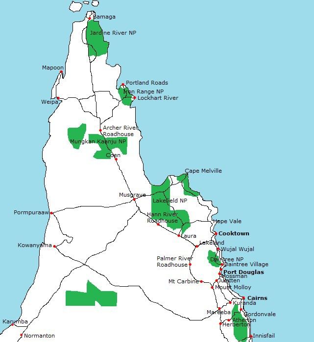
Cape York Pocket Guide 2021 – www.capeyorkaustralia.com

                                                  TABLE OF CONTENTS
HOW TO USE THIS BOOK.............................................................................................................................. 7
PART I: INTRODUCTION AND GENERAL INFORMATION............................................................................... 8
WHY DO PEOPLE GO TO CAPE YORK?........................................................................................................... 8
SO WHAT’S THERE? SHORTLY....................................................................................................................... 9
HIGHLIGHTS................................................................................................................................................ 12
PART II: PLANNING YOUR TRIP................................................................................................................... 13
REMOTENESS.............................................................................................................................................. 13
CLIMATE AND THE BEST TIME TO VISIT CAPE YORK ................................................................................... 14
   THE CLIMATE.......................................................................................................................................... 14
   Average Temperatures and Rainfall ...................................................................................................... 15
   WHEN TO GO TO CAPE YORK................................................................................................................. 19
HOW MUCH TIME SHOULD YOU TAKE?..................................................................................................... 23
GETTING HERE............................................................................................................................................ 24
   Visa......................................................................................................................................................... 24
   Flying...................................................................................................................................................... 24
   Train....................................................................................................................................................... 24
   Bus.......................................................................................................................................................... 24
   Driving.................................................................................................................................................... 24
GETTING AROUND...................................................................................................................................... 25
   Public Transport?................................................................................................................................... 25
   Tours...................................................................................................................................................... 25
   Self Driving – 2WD or 4WD?................................................................................................................... 25
   Renting a Vehicle.................................................................................................................................... 26
   Caravans and Camper Trailers................................................................................................................ 26
   Flying – Wet Season............................................................................................................................... 26
WHERE TO STAY......................................................................................................................................... 27
THINGS TO DO............................................................................................................................................ 28
   Four Wheel Driving................................................................................................................................. 28

                                © Copyright Katrin Holmsten ALL RIGHTS RESERVED

                                                                              3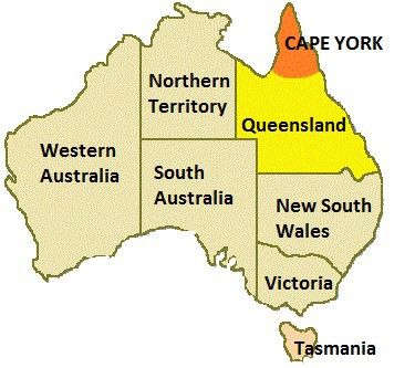
Cape York Pocket Guide 2021 – www.capeyorkaustralia.com

    Fishing.................................................................................................................................................... 28
    Swimming and Snorkelling..................................................................................................................... 28
    Bushwalking........................................................................................................................................... 29
    Wildlife and Bird Watching..................................................................................................................... 29
    Hunting................................................................................................................................................... 29
    Fossicking and Metal Detecting.............................................................................................................. 29
WHAT DOES IT COST?................................................................................................................................. 30
OTHER THINGS YOU SHOULD KNOW.......................................................................................................... 32
    Fuel Availability...................................................................................................................................... 32
    Banking Facilities.................................................................................................................................... 32
    Aboriginal Land Alcohol Restrictions and Entry Permits ......................................................................... 32
MAPS.......................................................................................................................................................... 33
PART III: THE GUIDE.................................................................................................................................... 34
    Cairns..................................................................................................................................................... 34
THE COASTAL WAY TO MUSGRAVE............................................................................................................ 35
    Cairns to Port Douglas............................................................................................................................ 35
    Port Douglas........................................................................................................................................... 35
    Mossman and Mossman Gorge.............................................................................................................. 36
    Daintree ................................................................................................................................................. 36
    CREB Track............................................................................................................................................. 36
    Daintree River to Cape Tribulation......................................................................................................... 37
    Cape Tribulation to Cooktown............................................................................................................... 37
    Cooktown............................................................................................................................................... 38
    Lakefield National Park........................................................................................................................... 38
THE INLAND WAY TO MUSGRAVE.............................................................................................................. 39
    Kuranda.................................................................................................................................................. 39
    Mareeba................................................................................................................................................. 39
Mareeba – Dimbulah Road......................................................................................................................... 40
Burke Developmental Road........................................................................................................................ 40
    Mareeba to Musgrave............................................................................................................................ 40

                                © Copyright Katrin Holmsten ALL RIGHTS RESERVED

                                                                              4
Cape York Pocket Guide 2021 – www.capeyorkaustralia.com

CENTRAL CAPE – MUSGRAVE TO THE OTT................................................................................................. 42
Musgrave to Coen...................................................................................................................................... 42
Coen to Archer River Roadhouse................................................................................................................ 42
Lockhart River, Portland Roads and Iron Range National Park .................................................................. 43
PDR to Weipa............................................................................................................................................. 43
Weipa to Telegraph Road........................................................................................................................... 44
NORTHERN CAPE YORK.............................................................................................................................. 45
The Old Telegraph Track and Bypass Roads............................................................................................... 45
Jardine River and National Park.................................................................................................................. 45
THE TIP OF CAPE YORK............................................................................................................................... 45
TORRES STRAIT ISLANDS............................................................................................................................ 46
INDEX......................................................................................................................................................... 50

                                © Copyright Katrin Holmsten ALL RIGHTS RESERVED

                                                                             5
Cape York Pocket Guide 2021 – www.capeyorkaustralia.com
FOREWORD
I wrote this free e-book as thanks for your interest in Cape York and my website.
I made it especially for the early planning stage of your trip, and it should help you with basic
decisions such as how to get here, how to get around, what kind of accommodation to use,
when to go, how long time to take and roughly what places you want to visit.
It is NOT anywhere near a complete travel guide. Compared to the complete Destination
Guide - Parts I and III – the general information about the area, and the detailed descriptions
about places to visit – are shorter by 90%.
Those parts of the book give you only a very basic idea of the subject. Part II – the planning of
your trip, is the longest and most important part of this pocket guide.
If, after reading this book, you decide that an independent trip to Cape York is too much for
you and you want to join an organised tour, you can skip the Destination Guide and just enjoy
the information in this book and the website. (NB: I strongly recommend you to think twice –
there is no reason why you cannot do Cape York on an independent trip!)
But if you decide to self-drive and explore the area without joining an organised tour with a
guide, you have a lot to win on getting the Destination Guide with all the locals’ tips on how to
make the most of this absolutely amazing trip of a life time! :-)
In addition to the Part II – the planning chapter, it has maps and detailed descriptions of all
places in Cape York, big or small – how to get here and get around, what is there to see and
do, where to eat and where to stay, where is the local tourist information centre, bank, post
and internet, medical centre, pharmacy and hospital, is there a local grocery shop, bottle shop,
RACQ and car mechanic – and anything else you need to know about each place.
And on top of that, it has the general information about the history, geology, plants and
animals of Cape York and where are the best places to see them; as well as information on
fishing, camping in national parks, FREE camping spots, Aboriginal land permits and alcohol
restrictions, quarantine restrictions, bushfires, tropical cyclones, dangerous animals and other
dangerous things, mobile phone coverage and other means of communication, fuel availability,
and of course, how to prepare your vehicle for such trip, as well as how to safely cross creeks
and rivers – which you likely will even in the driest time of the Dry Season.
In other words – the Destination Guide gives you invaluable local information and is a very
cheap investment to make the most of every dollar that you will pay for this trip :-)
But let’s get to the pocket guide first and do the first steps of the planning.
It is the FREE, small-size preview of the full guide.
© Copyright Katrin Holmsten ALL RIGHTS RESERVED
6Cape York Pocket Guide 2021 – www.capeyorkaustralia.com
HOW TO USE THIS BOOK
This book is written in a format of an e-book.
If you are familiar with e-books, you can skip this page.
Firstly, you need to save this book onto your device. It is a one-time newsletter
subscription download, so make sure you don’t lose your copy of the book!
Once you have saved the book onto your device, you can either print it, or read it on the
screen.
There are good things about both. I feel reading a printout is easier to take in, and is easier on
my eyes, than reading on the screen. However, reading the book on the screen enables you to
click on the links that are embedded in the text – which give you even more information, and
photos.
So, you probably get the best use out of this book if you print it, and read it from the
printouts, but have it open on the screen as well.
Some people have told me that it costs them lots of money to print an ebook - that is does not
need to be correct.
With a home laser printer and generic toners (only an online order away and you are set up to
print cheap in all future), it costs me less than $10 (less than ten dollars) to print 300 pages so
the 50 pages in this guide cost less than $2 to print.
I didn’t put any photos into this book because they take a lot more ink to print than the text,
and they increase the file size and make the downloading much slower. There are enough
photos on the website to give you a good idea about what places in Cape York look like, and
you can find them through the links in this book and the full Destination Guide.
And finally.. whether you only read this book or website or Destination Guide. I
would be really happy to hear from you.
Give me any feedback, good or bad, on the e-books and the website. Good feedback makes
me happy, bad feedback helps me to improve my work! Just because this pocket guide is free,
doesn't mean it doesn't have to be as good as possible.
And why not let other travellers know how you go, whether during, before or after your trip –
ideally all three! Write about your Cape York experience on Cape York forums or make your
own page about your adventure – other travellers would love to read it!
© Copyright Katrin Holmsten ALL RIGHTS RESERVED
7Cape York Pocket Guide 2021 – www.capeyorkaustralia.com
PART I: INTRODUCTION AND GENERAL INFORMATION
Queensland is the second largest state in Australia (after Western
Australia). It covers 1,730,648 km2 of land in north-eastern
Australia.
Its capital is Brisbane (population about 2 million), which is where
you are likely to first touch the ground when you fly from overseas.
North Queensland is a relative term but it usually means
everything north of, and including, Townsville. Townsville is the
largest city in north Queensland, with a population (181,743)
larger than Cairns.
Far North Queensland (FNQ) usually means everything north of, and including, Cairns.
Cairns (population 142,001) is the largest city in the FNQ, and the closest city to Cape York.
This is where you will arrive if you fly within Australia, and this is where your flight is
transferred to if you first arrive in Brisbane from overseas.
Cape York peninsula covers an area of about 140,000 sq km, which is almost the size of the
Australian state of Victoria. However the population size in comparison is about 18 thousand
versus six million! Most of the population lives in a handful of communities and small towns
such as Cooktown and Weipa.
WHY DO PEOPLE GO TO CAPE YORK?
While the reasons are combined, the most common reason is probably to have a photo taken
at the northernmost point of Australia.
But not far behind are the challenging four wheel drive tracks – the Old Telegraph Track,
CREB Track, Frenchmans Road and others.
Another very popular reason is fishing – there are plenty of great fishing spots, not only at
the famous Fisherman’s Wharf of Cooktown, but also in Seisia, Weipa, and many, many other
places – the peninsula is literally full of great spots to fish.
And there is some interesting history. Some of Australia’s best Aboriginal art sites are found
in Quinkan country around Laura. Early European history of pioneers can be discovered at
Somerset, Lockerbie and Old Laura Homesteads.
Hodgkinson and Palmer River Goldfields have gold rush histories. And in many places on the
peninsula there are relics from the Second World War.
© Copyright Katrin Holmsten ALL RIGHTS RESERVED
8Cape York Pocket Guide 2021 – www.capeyorkaustralia.com
SO WHAT’S THERE? SHORTLY...
Cairns is such a great city - my favourite one in Australia. It is relaxed, tropical, and
surrounded by beautiful mountains covered in lush rainforests.
It is worth spending some time in Cairns, particularly if you are not to return to the area.
Even though you can see the most attractions in the city in a few days, there are some unique
places to visit just outside (mentioned later).
And, Cairns is the best city in Australia for a trip to the Great Barrier Reef. Because the GBR
is closest to the mainland up north, the trips are shorter and consequently better value than
down south.
North of Cairns – you have two options – both roads finally meet in Musgrave.
The first is to follow the COASTAL road north to Cooktown.
On that way, you pass Cairns’ Northern Beaches (nice local communities), the touristy but
colourful Port Douglas, the quieter Mossman, and the beautiful Mossman Gorge – a nice
rainforest spot in the southern section of Daintree National Park.
Further north you come to the northern section of the same national park, which is much
larger than the Mossman Gorge section.
You first cross the Daintree River on a ferry, and then you come to a beautiful section of
tropical rainforest through which you’ll drive to Cape Tribulation.
North from there, the Bloomfield Road takes you to Wujal Wujal and further north past
Rossville and Helenvale to Cooktown.
North of Cooktown there are unsealed roads to and through Lakefield, Starcke, and Cape
Melville National Parks.
The road through Lakefield is a reasonable gravel road, while the ones to and through Starcke
and Cape Melville are partly small 4WD tracks.
Lakefield National Park is less remote but the road through it can still be quite bad after
rains. In the north-western end of Lakefield National Park, the road takes you to Musgrave.
If you choose the second, INLAND, option from Cairns, you will drive past the touristy
rainforest village Kuranda across the Great Dividing Range over northern Atherton
Tablelands to Mareeba.
Turn right towards north and the road will take you through the small towns Mount Molloy and
Mount Carbine to Lakeland.
© Copyright Katrin Holmsten ALL RIGHTS RESERVED
9Cape York Pocket Guide 2021 – www.capeyorkaustralia.com
Continue north and you come to Laura, past some Aboriginal rock art and the Palmer River
Goldfields, and then to Musgrave, where the inland and coastal road meet. This, second
option, is shorter and quicker, but both roads are worth doing – why not do one on your way
up and the other on your way down.
Cape York Peninsula. Map not to scale.
© Copyright Katrin Holmsten ALL RIGHTS RESERVED
10Cape York Pocket Guide 2021 – www.capeyorkaustralia.com
North of Musgrave, the road takes you to Coen and later Archer River Roadhouse, after the
turnoff to Mungkan Kaanju (now Oyala Thumotang) National Park.
North of Archer River Roadhouse there is a turnoff to the tiny community Portland Roads, the
Lockhart River Aboriginal Community, and Iron Range National Park – known as the
best place in Australia to see some flora and fauna found nowhere except on the Cape York
peninsula and Papua New Guinea (full detail in the Destination Guide).
Back on the Peninsula Developmental Road, it is about 15km north to the turnoff to the main
road to Weipa. Weipa is the second largest town on Cape York – a bauxite mining town with
some great fishing.
On the way back from Weipa you can take a shortcut via Batavia Downs to Telegraph Road.
Following it north, you cross the Wenlock River Bridge and Moreton Telegraph Station before
you enter the best part of this trip – the Old Telegraph Track.
This is a fun and adventurous four wheel drive track with many wet creek crossings. There are
the longer but quicker Bypass Roads around it if you want to avoid the Old Telegraph Track.
Just after the end of the Southern Bypass Road and the beginning of the Northern Bypass
Road, there are the famous Fruit Bat, Eliot and Twin Falls – nice spots to stop for a cool dip in
the water.
These are in Jardine River National Park, which, just like Iron Range, can be a good place
to see some plants and animals found nowhere else in Australia, such as the carnivorous
pitcher plants and many others.
In the northern end of the national park you will cross the Jardine River on a ferry (or if you
are really adventurous, at the Old Ford!).
Once you are past the river, you are in the Northern Peninsula Area. The largest township here
is Bamaga, surrounded by the smaller communities Seisia, New Mapoon, Umagico and
Injinoo.
Further north, past Lockerbie, you come to the tip of Cape York with Punsand Bay,
Somerset, and Pajinka – the northernmost point of mainland Australia.
IT IS NOT ALL RAINFOREST
Some people expect Cape York to be covered in tropical rainforest. The reality is – it is not.
There are pockets of rainforest in Daintree and Iron Range National Parks, but for most of the
time you will drive through dry eucalypt woodland.
And there is nothing wrong with that – it’s still fantastic!
© Copyright Katrin Holmsten ALL RIGHTS RESERVED
11Cape York Pocket Guide 2021 – www.capeyorkaustralia.com
HIGHLIGHTS
• The Tip of Cape York is the main goal of most trips and it is great to stand on the
northernmost point of mainland Australia. It’s not only for the sign and the photo but also for
the views over the bright blue ocean – an absolutely magnificent place.
• Torres Strait Islands are beautiful, and on a sunny day the waters surrounding them are
even brighter blue than those near the mainland. More than that, these islands have a very
interesting history and a great mix of cultures.
• The Old Telegraph Track is said to be the last of its kind in the world. It is mostly slow going
and can be hard in places, but that’s what makes it so special. And it is not maintained thanks
to the Bypass Roads. If you decide to do it, it will be the most exciting part of your trip :-)
• Iron Range National Park is a great place to discover some of the flora and fauna that Cape
York only shares with Papua New Guinea. While palm cockatoos, eclectus parrots, green
pythons and cuscuses are also found in other parts of the Cape York peninsula, Iron Range is
one of the best places to try to spot them.
• Lakefield National Park is huge, remote and adventurous. A great place to camp, fish and
watch some excellent birdlife. Watch out for crocodiles too.
• Daintree National Park is not only one of the most biologically diverse regions in the world –
it contains the world’s oldest living rainforest (yes, it’s true!).
• Palmer River Goldfield is the place to discover what’s left from one of the largest gold
rushes in Australia’s history. Its main town used to be the capital of Cape York.
• Hodgkinson Goldfield is smaller but in many ways even more amazing if you look into it.
With the beautifully restored Tyrconnell Mine, and the fascinating Mount Mulligan - not only
known for the mining disaster but also for its massive cliff face, and some fantastic ruins of the
mine and the town itself.
• Chillagoe is not only a great outback town – it has some very interesting geology. Its
limestone caves and granite boulders have been left behind from a time when the area was on
an ocean bottom and covered by coral reef.
© Copyright Katrin Holmsten ALL RIGHTS RESERVED
12Cape York Pocket Guide 2021 – www.capeyorkaustralia.com
PART II: PLANNING YOUR TRIP
REMOTENESS
Is remoteness dangerous?
A lot of people would say yes.
The reason is that people are scared of the unknown. The more used they are to the situation
the less scared they are.
The more you travel in remoteness the more you realise how it is not dangerous as long as
you are properly prepared.
If you keep common sense with where you go you should not get bogged.
If you have your vehicle mechanically prepared and you carry recovery gear, you have
done what you can to avoid getting stuck because of vehicle problems.
You cannot completely avoid them but can minimise the risk, so if it still happens, for that you
carry enough food and drinking water so that you can wait for someone to come along.
If you don't want to wait, or you travel extra remote - off the main roads, or out of season,
where and when there are not many other people around, you can carry means of commu-
nication so that you can get help to arrive.
There are two main kinds of situations – one is mechanical emergencies (above), and the
other one is medical emergencies.
If you have health issues of your own you obviously have to carry enough medication, and
more than enough mediation if you want to cover extra time if you get stuck.
Just like with the mechanical emergencies you can only do so much, but you cannot com-
pletely avoid a medical emergency should there be an accident or a snake bite.
That is about the only situation where remoteness is dangerous, and you cannot do anything
to help it except carry means of communication – the best and most accurate ones possible,
which in a bad situation will be your only life saver.
There is a long chapter in the Destination Guide that outlines the means of communication,
which ones are necessary, and which ones are best for each situation (yes, there is a differ-
ence that can save your life!).
It also outlines which kinds are best in Australia, northern Australia and Cape York – and which
service providers there are and which ones are the best value (I have tested them over the
years and some end up many times the price compared to others due to hidden costs).
You can work out which one is the best for you because you also want to use it on your
other travels (probably in other parts of Australia or in the world) in the future.
You will be surprised just how affordable the emergency communications are nowadays – not
thousands of dollars like it used to be – if you can afford a Cape York trip – you can af-
ford them :-)
© Copyright Katrin Holmsten ALL RIGHTS RESERVED
13Cape York Pocket Guide 2021 – www.capeyorkaustralia.com
CLIMATE AND THE BEST TIME TO VISIT CAPE YORK
While most people are used to four seasons, in the tropical northern Australia we don’t have
spring, summer, autumn and winter. We only have two distinctive seasons – the wet and the
dry. They coincide with other parts of the world in the following way:
Northern Hemisphere Southern Hemisphere Northern Australia
(Europe, the US) (southern Australia, NZ) (Cape York)
Winter Summer The Wet
Summer Winter The Dry
While in many parts of the world, including the southernmost parts of Australia, summer is
more comfortable than winter, in northern Australia it is the opposite. The best season is the
Dry – when it is winter in other parts of Australia.
THE CLIMATE
The Dry Season (roughly May to November)
The temperatures are in the nice 20-ies or 30-ies (Celcius), the skies are clear, days are sunny
but not too hot, and rains are (UPDATE used to be!) very rare, however in the recent years
they have increased somewhat (in some places they have actually increased a lot but not quite
that much on Cape York).
The Wet Season (roughly November to May)
The wet season on the other hand brings a whole lot more rain, a lot more humidity, and a lot
more uncomfortable temperatures. There are two distinct stages in The Wet, with totally
different weather patterns.
The Early Wet – The Build-up (roughly November to January)
The early wet is also called the Troppo Season, because people go crazy from the heat. It
starts with rising temperatures that get quite unbearable.
Once it’s hot enough the days start with a lot of sun and scorching temperatures, which by the
lunch time have built to the point where the heat starts building tropical storm clouds that
grow thick upwards.
© Copyright Katrin Holmsten ALL RIGHTS RESERVED
14Cape York Pocket Guide 2021 – www.capeyorkaustralia.com
In these clouds, massive thunderstorms build. Often by midday or early afternoon these clouds
produce severe electrical storms.
Lightening can last for hours and the rain that follows can last for the rest of the day. But this
is still not really the rainy season. It’s the ‘scattered showers’ or ‘storm season’ – the build-up
to the real rains.
The Late, “Proper” Wet – Monsoonal Rains (roughly January to May)
Then, quite suddenly, the monsoonal rains (that move seasonally between us and the south
eastern Asia), arrive.
These are the kind of all-day-grey-skies rains with no storm activity. Once they arrive, quite
soon they cool the temperatures down, which stops the thunderstorms from building.
This part of the Wet season is NOT hot, but it is very WET. Most days the skies are grey and it
rains right from the morning, and it rains a lot.
Everything gets wet, mould starts growing, and with constant rains and the lack of sun, the
temperatures are so cool that during this part of the Wet, we tend to wear jumpers (oh - and
we love this break from the heat! ;-)
Average Temperatures and Rainfall
Cairns and Around
Temp Jan Feb March Apr May Jun Jul Aug Sept Oct Nov Dec
(°C)
Average 31.8 31.3 30.5 29.2 27.4 25.9 25.5 26.3 28.0 29.7 30.7 31.8
daily
max
Average 23.4 23.3 22.6 21.1 18.9 17.3 16.3 16.3 17.8 19.7 21.3 22.7
daily
min
Rain Jan Feb March Apr May Jun Jul Aug Sept Oct Nov Dec
(mm)
Average 419 422 460 264 110 72 39 42 43 50 98 203
monthly
Cooktown
© Copyright Katrin Holmsten ALL RIGHTS RESERVED
15Cape York Pocket Guide 2021 – www.capeyorkaustralia.com
Temp Jan Feb March Apr May Jun Jul Aug Sept Oct Nov Dec
(°C)
Average 32.0 31.5 30.6 29.5 28.0 26.6 26.3 27.0 28.7 30.2 31.6 32.1
daily
max
Average 24.1 23.9 23.5 22.7 20.6 18.7 17.8 18.4 20.2 22.3 23.3 24.0
daily
min
Rain Jan Feb March Apr May Jun Jul Aug Sept Oct Nov Dec
(mm)
Average 284 354 360 166 63 37 32 21 17 25 80 210
monthly
Coen
Temp Jan Feb March Apr May Jun Jul Aug Sept Oct Nov Dec
(°C)
Average 31.6 30.9 30.3 29.6 28.7 27.8 27.5 28.4 29.9 31.7 33.0 33.0
daily
max
Average 22.6 22.4 22.0 20.6 19.0 17.2 16.6 17.0 18.3 20.3 22.7 22.4
daily
min
Rain Jan Feb March Apr May Jun Jul Aug Sept Oct Nov Dec
(mm)
Average 282 290 247 93 15 9 6 4 3 13 54 160
monthly
Lockhart River
Temp Jan Feb March Apr May Jun Jul Aug Sept Oct Nov Dec
(°C)
Average 31.6 31.2 30.6 29.7 28.7 27.4 27.0 27.7 28.9 30.3 31.8 32.2
daily
max
Average 23.6 23.6 23.4 22.9 21.9 20.1 19.2 19.1 20.3 21.7 22.9 23.5
daily
min
© Copyright Katrin Holmsten ALL RIGHTS RESERVED
16Cape York Pocket Guide 2021 – www.capeyorkaustralia.com
Rain Jan Feb March Apr May Jun Jul Aug Sept Oct Nov Dec
(mm)
Average 395 395 454 301 113 62 42 29 16 27 73 205
monthly
Weipa
Temp Jan Feb March Apr May Jun Jul Aug Sept Oct Nov Dec
(°C)
Average 32.0 31.3 31.8 32.3 31.9 31.0 30.9 31.8 34.2 35.5 35.5 33.7
daily
max
Average 24.2 24.1 23.8 22.8 21.3 19.9 18.6 18.5 19.4 21.7 23.4 24.2
daily
min
Rain Jan Feb March Apr May Jun Jul Aug Sept Oct Nov Dec
(mm)
Average 445 586 433 93 23 5 1 7 2 18 107 272
monthly
The Tip and Torres Strait Islands
Temp Jan Feb March Apr May Jun Jul Aug Sept Oct Nov Dec
(°C)
Average 29.9 29.6 29.7 29.7 29.1 28.3 27.7 28.0 28.8 30.1 31.2 31.0
daily
max
Average 24.8 24.6 24.6 24.7 24.3 23.2 22.5 22.6 23.3 24.2 25.3 25.4
daily
min
Rain Jan Feb March Apr May Jun Jul Aug Sept Oct Nov Dec
(mm)
Average 419 378 357 214 46 21 9 8 3 11 37 241
monthly
© Copyright Katrin Holmsten ALL RIGHTS RESERVED
17Cape York Pocket Guide 2021 – www.capeyorkaustralia.com
Tropical Cyclones (roughly November to May)
Both the early and the late, (but more so the late) Wet Season is also the season for
tropical cyclones (also called hurricanes and typhoons in the Northern Hemisphere).
We may have cool temperatures from monsoonal rains here on the peninsula, but out on the
ocean the air and the waters are hot - the combination that creates tropical cyclones.
Due to the rotation of the Earth, tropical cyclones mainly move from east to west, so most of
our cyclones come from the waters of the Coral Sea (and they are the strongest ones).
Occasionally a cyclone can take a different path, so occasionally we may get a cyclone that has
formed in the waters north of Australia, and may approach the Cape York Peninsula from the
west, from the waters of Gulf Savannah (but they are usually weaker ones).
A tropical cyclone is a powerful wind system that can seriously threaten life and damage
property.
When a cyclone first hits the coast it leaves behind destruction.
Once it moves further inland the winds die off because they don’t get the fuel from the warm
ocean waters anymore.
The system turns into what is called a tropical low and it always brings a lot of rain to the area
it passes through.
What Should You Do as a Traveller
The roads in Cape York are most often closed this time of the year due to the wet season.
So most people up in Cape York this time of the year are the locals (and people who may work
in the mines or elsewhere and fly in and out).
Flying is just about the only way to get up here during this season, and you as a traveller are
not likely to find yourself in Cape York this time of the year.
If you do find yourself here - or elsewhere in the cyclone area such as along the coast of north
eastern Queensland (also the Top End of Northern Territory or the north western coast of
Western Australia), keep checking the BOM website for any cyclones.
They turn up quickly, so it’s worth having a look every day, because if you are on a travelling
foot, you may want to know about it in a good time (you might need more time than the locals
who have their cyclone plans worked out over the years).
If you see one, think ahead in case you do have to evacuate. Where will you go, how will you
go, what time it takes - just plan a bit.
If it hits, it usually hits within a week from when it first appeared on the BOM map.
© Copyright Katrin Holmsten ALL RIGHTS RESERVED
18Cape York Pocket Guide 2021 – www.capeyorkaustralia.com
If a cyclone does get closer and is a likely threat, it also gets out on the news, so listen to the
radio and check the news on TV or internet, whatever is accessible for you.
If a cyclone starts being a threat and you are in the area, you get cyclone warnings through
TV and radio. Now you should really listen carefully to all the information and advice about
what to do.
It is usually good enough to keep yourself in a solid, preferably concrete or brick building, in a
room with no windows (bathroom), and - before the cyclone - stock up food, because shops
maybe closed for many days after the cyclone.
Also be aware that you may be without power for a period of time after the cyclone, so
depending on your needs, but at least – you should stock up some torch batteries and drinking
water, and get some cash out because ATMs may not work for a while.
That’s if you are in a building. I presume you are not camping around this time of the year due
to the rains, but if you are, of course you have to find a shelter. Try and get into a motel room
and try to get your vehicle parked under a cover.
If you are travelling in a caravan and you are not getting it garaged or under a cover, you may
want to leave the area while you still can.
WHEN TO GO TO CAPE YORK
Apart from when you get time off from work, there are two main factors to consider when
making the decision when to go to Cape York – the climate and the crowds (there are
actually more factors and they are in the Destination Guide).
The Climate
The Late Wet (roughly December to May)
And there is one main thing with it. During the late wet, the roads to and in Cape York
can be CLOSED due to floods. So you might technically not be able to travel to and within
the peninsula during that time of the year - period.
I strongly recommend you to not to plan your trip earlier than for May, or even early
June if you want to be sure.
The exact time of the opening of the peninsula after a wet season is never possible
to predict!
Some years you might get away earlier, others not – but it can make it difficult to
make definite plans for a trip before early June.
© Copyright Katrin Holmsten ALL RIGHTS RESERVED
19Cape York Pocket Guide 2021 – www.capeyorkaustralia.com
And there is one important difference between the months of April and May.
April is still cyclone season – and we have had some very strong cyclones right until late
April.
Something happens when May starts - and the cyclones completely disappear (or so
they have so far - unless it, too, changes one day!).
Because a cyclone can happen quickly enough to close the only road up to the Tip within a
week – May is a better month than April (although as said above, May is also not
completely safe, still).
It would be a pity if you planned to spend your annual leave to do your Cape York trip, and
ended up not being able to do it because the roads didn’t open!
If you make a plan for this time of the year – make a flexible one - with a Plan B in
case that Cape York fails.
To monitor the roads closer this time of the year - Destination Guide has a list of all the
places where to check road openings (and they are local sources - not the RACQ website!).
I also include road openings in the newsletters this time of the year. If you’re reading this
book, you should have already subscribed to them.
The Early Dry (roughly May to June)
Once the Dry Season starts and the roads have had a chance to dry, they open one by one,
wherever the conditions are good enough. So in the early dry it might be that the main road is
passable, but the smaller back tracks are still closed.
Water levels are up in the creeks and rivers, so crossing them is more challenging
than in the Late Dry. The good thing is that the nature is still green and lush, and the wildlife
is more active and easier to spot.
The Height of the Dry (roughly July to August)
Weather-wise, this is the best time to travel on the peninsula. The weather is dry, sunny and
relatively cool, and the water in the creek crossings is lower than it was during the Early Dry.
It is easier to cross the creeks although the waters are still higher than they will be in the Late
Dry Season.
© Copyright Katrin Holmsten ALL RIGHTS RESERVED
20Cape York Pocket Guide 2021 – www.capeyorkaustralia.com
The Late Dry (roughly September to November)
In the Late Dry, temperatures start to rise gradually. From September through October to
November, it gradually gets hotter and hotter, which makes travelling more uncomfortable,
particularly when it is a camping trip.
You can keep cool day time by air conditioning in your vehicle or having dips in swimming
holes, but sleeping in the tent night time becomes particularly uncomfortable.
The Early Wet (roughly November to December/January)
By now the temperatures have risen to the point where thunderstorms start building. The
roads are still open but you start getting storms in the afternoons. They are spectacular but
could also be scary if you happen to be in the middle of it camping in the tent.
It starts gradually raining more and more, and some time around December / January but that
can vary, roads start becoming impassable and some get closed for the Wet Season.
The Crowds
Many of us don’t like crowds on a Cape York holiday, but some of us dislike them even more
than others. Cape York is a wilderness experience and crowds don’t really belong here.
Then again if you’re travelling during the season when there are a lot of people, it can be safer
because should you break down, the help is closer.
There are two main factors that affect the crowds in Cape York, and time-wise they overlap
each other.
The first is the height of the Dry Season (roughly June – August), when everyone wants to
come up here because of the most comfortable weather.
The second is the winter school holidays, which start in the late June and end in the mid or
late July.
It does top the already crowded camping grounds up with even more people, and is the time
to avoid most, if you don’t like sharing your wilderness experience with lots of other people.
The crowds are smaller during the Early Dry when you see a smaller amount of more
adventurous people; and in the Late Dry when you see some people who are happy to put up
with the hotter weather in order to avoid crowds.
© Copyright Katrin Holmsten ALL RIGHTS RESERVED
21Cape York Pocket Guide 2021 – www.capeyorkaustralia.com
Summary – When to Go
Weather Crowds
April - May Some years the roads are still If the roads are open, there are not
closed. If they are open, it is still many travellers yet, only a smaller
very wet; April is still cyclone amount of more adventurous ones.
season meaning the Cape can If you are planning a trip for
close on a short notice; but even these months, your plan should
in May the water levels are still up be flexible with extra time, or
in the creeks/rivers and crossing you should have a Plan B in case
them is more challenging. the roads close!
June All the main roads are usually By early June, a lot more people
open by early June, unless it has start arriving. By mid June, the
been an extremely bad Wet most crowded time has started, and
Season or there was an by the end of the month, the school
exceptionally late cyclone. But holidays start, creating the peak
even if the weather is dry, the time of the year.
creek and river waters can still be
up because it's still early after the
Wet Season.
July - August The dry season has usually really July is still the most crowded time
kicked in by now, and July is the of the year (peak while it's still
coolest month, and therefore for school holidays), but August starts
most people, the most dropping.
comfortable month to travel.
September - October Temperatures are gradually rising, The big traveller numbers have
and getting gradually more dropped down. There is still a small
uncomfortable for a camping trip, peak during the September /
but it is still sunny and dry – no October school holidays, but
storms or showers. nothing like in June / July, and after
that the high season is officially
over.
November The temperatures are now so hot There are not many travellers left
that thunderstorms can build in by now. You can enjoy the
the afternoons. The scattered but wilderness without crowds, and on
heavy showers they bring make some more remote tracks you are
some roads soggy. likely not to see a person.
December There are more and more There are almost no travellers that
thunderstorms. In some years, the are still around. And you should get
real wet season (The “late wet” = out of here too, because the roads
monsoonal rains) kicks in in can close any time now.
December, which means the roads
can close.
© Copyright Katrin Holmsten ALL RIGHTS RESERVED
22Cape York Pocket Guide 2021 – www.capeyorkaustralia.com
HOW MUCH TIME SHOULD YOU TAKE?
How Quickly You Can Go
The distance between Cairns and the tip of Cape York is roughly 1000km (actually
1027 and 1150 depending on which way you take). That distance can normally be driven in
one long day, but that is a lot more difficult on Cape York.
Distances mean little in Cape York when counting the travel time. The roads are often
corrugated, can be muddy and sometimes extremely slippery; and you may have to drive very
slowly in some parts just to get through if the conditions are bad.
It is the road conditions that determine the travelling time in Cape York, much more
than the distances alone.
How Quickly You Want to Go
The other question is in what pace you like to travel. People are so different when it
comes to that. Some people have no patience to camp in the same spot for more than one
night. Others don't enjoy moving on every day and enjoy staying in each place longer.
Also, how much in a day do you like to drive? The shorter the time you plan for your trip
the more of each day you spend behind the wheel. But is it enjoyable? Is it what you want
your trip to be all about?
Personally I am a really slow goer. I can spend weeks in places like Iron Range and the Old
Telegraph Track. And months in places like Weipa, to discover everything in and around it in
detail.
But I know, most people don't have that kind of time, and this is where the main question
comes in – how much time do you actually get off work.
I really hope that you get four weeks, and use them all for your Cape York trip.
If you really want to do Cape York properly and enjoy your experience without needing to
rush, this is the time you need. But I know that a lot of people don't get that much time.
If you have two weeks, you still get to go all the way up to the tip, do the Old Telegraph
Track, and visit Weipa, Lockhart River and Iron Range National Park. But you are watching
your time and moving on quite quickly; and you would be hard pressed to get much more than
the above places into your trip (Actually, what you get in is difficult to estimate because it
depends on how well you use your time and whether you want to relax or get in as much as
possible).
Any shorter than two weeks, I really don't recommend. You can make your way up to the
tip and back in a week, but you would not see much except the main road through your
© Copyright Katrin Holmsten ALL RIGHTS RESERVED
23Cape York Pocket Guide 2021 – www.capeyorkaustralia.com
windscreen. You would spend your days mostly behind the wheel, racing through it (and still
pay the same expensive fuel price that you'd pay if you took your time to see more).
If that's how little time you have got, it may be worth putting your plans on hold and do it
when you have more time.
GETTING HERE
Visa
If you are an overseas traveller (except from New Zealand), you will need a visa to enter
Australia. You can apply and pay for it online on DIMIA website.
Flying
Most Australians would pack their 4WD and drive to Cape York, but overseas visitors will have
to fly. Cairns has an international airport, however, most often it is cheaper to take an
international flight to Brisbane (Sydney, Melbourne..) and then a domestic flight from there to
Cairns than to fly to Cairns directly.
You can of course use any airline for your international flight, but within Australia, you can get
to Cairns by Qantas 13 13 13; Jetstar 13 15 38 (+61 3 9092 6500 from overseas); or Virgin
Blue 13 67 89 (+61 7 3295 2296 from overseas). The latter two are budget options. Booking
on the internet is free while over the phone fees may apply.
Train
Train is quite a comfortable option which, as opposed to flying, enables you to see the
countryside. The only train trip to Cairns comes from the south, from Brisbane. The most
comfortable train is the Tilt Train 1300 131 722. All other Queensland trains are found on
Queensland Rail website.
Bus
Long distance buses are a common means of transport for travellers in Australia. They are
cheaper than planes and trains, but far less comfortable. You are not even allowed to eat or
drink on-board and overnight trips mean you will be sleeping in your seat. You can also get
arrival/departure times in the middle of the night which is not fun. This is how long the trips
are: Brisbane – Cairns: 29 hrs; Sydney – Cairns: 46 – 47 hrs; Darwin – Cairns (via
Townsville): 61 hrs. There used to be two companies, which now have joined into one –
Greyhound: 1800 661 8747.
Driving
Driving is by far the best option, as it is flexible and you can stop when and where you choose
along the way and stay where you want. If you can take your time, it’s a great way to extend
© Copyright Katrin Holmsten ALL RIGHTS RESERVED
24Cape York Pocket Guide 2021 – www.capeyorkaustralia.com
your trip and see even more new places. The full Destination Guide has itineraries with
FREE camping spots along the roads to Cape York from Brisbane, Sydney, Melbourne
and the Northern Territory.
GETTING AROUND
Public Transport?
Although there are some historical railways in Cape York, you cannot travel the peninsula by
train. The only places you get to by train are just south of the peninsula, such as Kuranda,
Mareeba, Dimbulah, Almaden and Chillagoe. Although long distance buses take you up along
the eastern coast of Australia and around the rest of Queensland, you cannot travel Cape York
by Greyhound. Your only realistic options are self driving or a tour. And of course – flying,
which is the only way to get here during the Wet Season (apart from the barge).
Tours
There are several tours available, starting from Cairns, Port Douglas and other places just
south of Cape York. But I really don’t recommend you to take a tour, unless you are seriously
out of time, happy to pay a lot of money, and happy with seeing very little in a short time. It’s
so much more fun to do it yourself, including all the challenging drives.
I really cannot see a good excuse why you couldn't do it yourself. Even if you haven't got a
four wheel drive – renting one is cheaper than a tour, and buying one doesn't have to cost you
an arm and a leg. I did my first Cape York trip in a $3,500 vehicle – which got through
everything perfectly. All you need is to make sure it is mechanically sound before you leave.
If you are wondering about your driving skills, let me tell you that the night before I left for
my first, solo trip to Cape York, I was shown how to operate a 4WD for the first time
in my life. And I did at least half of the Old Telegraph Track on my own before I met some
other people and joined in with them. The thing about Cape York is that in a lot of places, four
wheel driving is not difficult, and you are not forced into hard four wheel driving. There are
different bypass roads around all the hard bits, including the Old Telegraph Track, and parts of
it (all detail in the full Destination Guide). You can do it!
Self Driving – 2WD or 4WD?
I probably shouldn’t say that, but technically you can get to the Tip of Cape York and back in a
2WD. But despite the fact, it is NOT smart to do so.
For the first thing, you’d wreck your 2WD on corrugations – they are not made for
those roads. It would also mean paying almost the same money for the fuel (and it’s not
cheap up here!), and missing out all the fun. The best parts of Cape York are the adventurous
four wheel drive tracks that are off the main roads.
© Copyright Katrin Holmsten ALL RIGHTS RESERVED
25Cape York Pocket Guide 2021 – www.capeyorkaustralia.com
There are some people who don’t care and only want to drive the main roads up and down to
have been to the northernmost point of Australia. But they don’t know what they are missing
out – Cape York is so much more than just the Tip of Australia!
I really don’t recommend you to do Cape York without a four wheel drive, and not only that –
a proper 4WD – with low range gear and high clearance.
Buying a Four Wheel Drive in Cairns
A lot of travellers buy and sell vehicles in Cairns (and other Australian cities), so buying one is
not impossible and doesn’t need to be an expensive option. Like I said just before, my first
vehicle (an old Holden Jackaroo) that I took up to Cape York, and that did the trip perfectly
fine, costed me $3,500 (a few years later we even tried a $2,000 Pajero and it did all the
hardest 4WD tracks). So you don’t need a $50,000 dollar car to do Cape York. Of course, you
have to know how to check the mechanics or take it to a car mechanic to have a look at it, like
with any other vehicle you buy. There are plenty of travellers buying and selling travel vehicles
in Cairns, and you can also check websites like Gumtree (www.gumtree.com.au).
Renting a Vehicle
If you rent a vehicle, do rent a four wheel drive, and a proper four wheel drive. Another thing
to do is to check if they have restrictions on the roads that you are allowed to do. You may not
be allowed to do the Old Telegraph Track, Frenchman’s Road, CREB Track and all the other fun
tracks. If you still do them and something happens, you will be paying dearly, so it is worth
picking the right company. All the companies that allow you to do the fun tracks, and which
ones (as they vary between the companies) – are now in the Destination Guide.
Caravans and Camper Trailers
I have met people who have pulled their caravan all the way up to the Tip and back (Update
2017 - that sentence was written so many years ago!). They used to be not many at all, but
nowadays they are on the increase. As was said about the two wheel drives above, this means
you won’t get to do the off-road stuff (unless, obviously, you put some time and effort into
planning around it. FREE places to store your van are in the Destination Guide). And - you will
shake your van on corrugations. If you do want to bring a bed along, look into an off road one,
or even better a trailer. UPDATE 2018 – there is now a Caravan Guide found inside the
full Destination Cape York :-) UPDATE 2019 – there is now a Trailer Guide, too :-)
Flying – Wet Season
Flying is not a common way to do Cape York, but if you don’t care about the drives, haven’t
got a 4WD and just want to be to the Tip or any other place, flying is actually not a bad way to
do it. It is often the only way, apart from the boat, to get around during the Wet Season.
© Copyright Katrin Holmsten ALL RIGHTS RESERVED
26You can also read