CATS-ISS (Cloud-Aerosol Transport System for ISS)
←
→
Page content transcription
If your browser does not render page correctly, please read the page content below
CATS-ISS
                                              (Cloud-Aerosol Transport System for ISS)
                                                        Science Overview
                                                            Directed Opportunity
                                                      Payload Delivery Date: April 2013
                                                  Planned Launch Readiness Date: mid-2013

                                             CATS is a directed opportunity funded directly by NASA Science Operations
                                             Mission Directorate (SOMD). Total budget $10M (w/ contingency)
 Japanese Experiment Module-Exposed
                                             Project initiated in April 2011, on 24‐month rapid schedule to launch
Facility (JEM-EF) attached payload for the
     International Space Station (ISS)
                                             Pathfinder for future US Science payloads
CATS-ISS Organizational Chart
Matthew McGill: CATS PI
                                      M. McGill / 613.1                                             E. Welton / 613.1
                                     PI/Project Manager                                          Science Definition Lead
Judd Welton: Project Scientist
             S. Scott / 694                                     J. Cavanaugh / 544                      P. Colarco / 613.3
                                                           Instrument Systems Engineer                  Data Assimilation
CATS Project Science Team:
          Instrument Manager

Stephen Palm
William Hart                                               S. Kunkel / GSFC 592 & JSC
                                                            Project Interface Facilitator
Dennis Hlvaka
John Yorks
                                       P. Adkins / 321                         JSC / ISS
                                       Payload Safety                 Safety & Mission Assurance
Modeling Support:
Pete Colarco
Arlindo da Silva
Virginie    Buchard
M. Shupp / 613.1
Resource Analyst
                 W. Mamakos / D.I.
                    Mechanical
                                     P. Cleveland / ESI
                                          Thermal
                                                          S. Scott / 694
                                                              Optics
                                                                            J. Cavanaugh / 554
                                                                                 Electrical
                                                                                                      Fibertek
                                                                                                       Laser

No Competed N.Science     Team at the moment
               Galassi / D.I.
               Structural
                                              (ROSES NRAFibertek
                                            Axsys
                                          Telescope
                                                           under discussion)
                                                                              System Software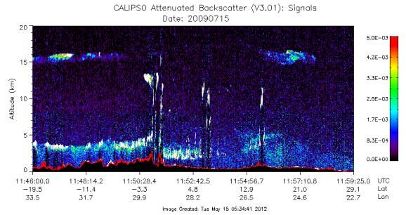
CATS-ISS Science Overview: Research & Operational Goals

                                                                                                                                                                           Near Real Time

                                                                                     ISS
                                                                                                                                                  CATS Processing Center                    Operational Forecast
                                                                                                                                                       NASA GSFC                                  Centers

                                                       Aerosol and Cloud                                                                                             AIR QUALITY MONITORING
                                                       Properties
                                             14                                                                                                                                                      Forecasting
                                                                                          GLAS Lidar
                                                                                                                                                     Research
                                             12

                                             10

                                             8

                                             6

                                             4

                                             2
                                                                                                                                                                            STRATEGIC (DoD)
                                             0
                                                  -2   0   2   4   6   8   10   12   14   16   18    20   22   24   26   28   30   32   34
This image cannot currently be display ed.

                                                                                          Latitude

                                                                                          MODIS Image

                                                                                                                                                                                        HAZARDOUS PLUME
                                                                                                                                                                                           TRACKING
                                                                                                                                             Aerosol Modeling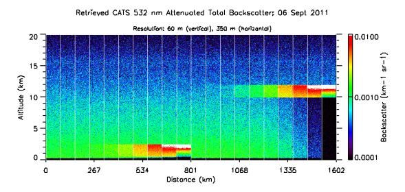
Climate Studies & Aerosol Forecasting
Observations provide constraints needed to model aerosol
properties and behavior
Even with those constraints, modeling aerosol distribution
and loading is difficult
• Aerosol climate impacts are proportional to loading!
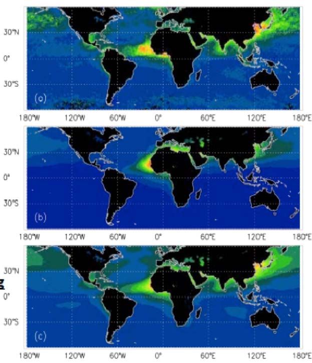
MODIS Aerosol Observations Model aerosol loading improves significantly after
assimilating coincident observations, but only for 2D total
loading (as shown)
Despite agreeing on total loading, current models
diverge significantly on vertical distribution and aerosol
Zhang et al, 2008
type (ie pollution vs dust)
Modeled Aerosol Loading
As a result, it is difficult to attribute aerosol loading to
human vs nature (ie pollution vs dust)
• Determining human induced portion of aerosol
climate impact is the primary goal!
Model Results after Assimilating MODIS Aerosol climate forcing is dependent on vertical location:
are aerosol below, mixed with, or above clouds?
• Aerosol‐Cloud interactions comprise the largest
Models are used to determine climate forcing uncertainty in climate forcing
and predict future climate change
Climate Studies & Aerosol Forecasting

                                          Lidar provides:

                                          (1) information on the vertical profile of aerosol type,
                                          and properties (ie loading)
                                                 • similar information on clouds

                                          (2) heights of aerosols and clouds, and improves our
CALIPSO Observations
                                          understanding of how and when aerosol‐cloud
                                          interactions occur

                                          CATS will provide data to constrain modeled aerosol and
                                          cloud properties, and improve model distributions and
                                          climate forcing through assimilation

CALIPSO Feature Mask                                    GEOS-5 Model Feature Mask

                                                                                    Welton, et al (2011)
   Marine Aerosol      Pollution   Dust       Pollution-Dust        Smoke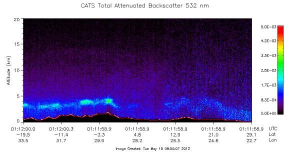
ACE Mission Studies & Tech Demo

ACE Mission Considering Different Mission Options: 1 or 2 Platforms

                                                                                      ACE Mission still in study phase:

                                                                                      If selected launch in 2020’s

                                        ACE Report Chapters 1 & 9: Introduction & Mission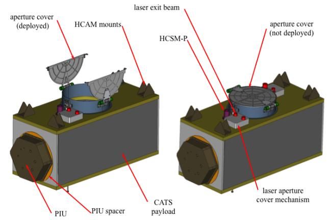
Advanced Lidars: Particle Properties from High Spectral Resolution Lidar (HSRL)
HSRL
Total Signal, as measured by traditional backscatter lidars
PT (r) C M (r) P (r)e
2 0z ( r )dr 2 0z P ( r )dr
M
e
HSRL techniques provide additional channel containing only
molecular backscatter
2 0z ( r )dr 2 0z P ( r )dr
PM (r) C M (r)e M
e
and more accurate profiles of extinction can be solved directly if an
accurate molecular model is used. Profiles of backscatter and the
lidar ratio are also generated.
1. Use absorption notch filter to eliminate aerosol
signal.
Presence of Doppler shift will preclude measurement
(e.g., off-nadir not easy).
Or
2. Use Fabry-Perot etalon to image aerosol/molecular
spectrum
Doppler shift not a problem, but FP has low efficiency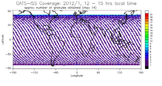
Advanced Lidars: Exploring the Information Content & Simulating CATS

                                                GEOS‐5 Inputs:

                                                Met Data
                                                Solar Stokes TOA (I,Q,U)
                                                Surface Albedo & Type
                                                Aerosol:
                                                BKS, EXT, Depol, SSA for
                                                sulfate, sea salt, dust, black &
                                                organic carbon

                                                Dust aerosols fully polarized

                                                No Clouds, yet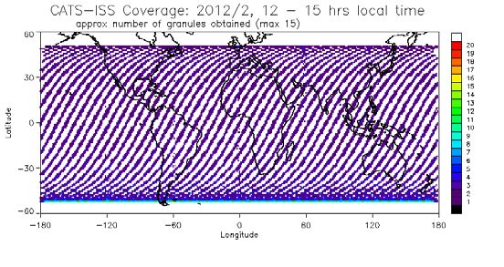
Advanced Lidars: Exploring the Information Content & Simulating CATS

                                                          Sulfate BKS

                                                          Seasalt BKS

                                                           Dust BKS

                                                            OC BKS

                                                          BC BKS * 10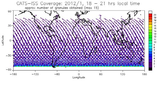
Advanced Lidars: Exploring the Information Content & Simulating CATS

BKS 355 nm                                    EXT 355 nm

BKS 532 nm                                    EXT 532 nm

BKS 1064 nm                                   EXT 1064 nm
Advanced Lidars: Exploring the Information Content & Simulating CATS

BKS 355 nm                                  DEPOL 355 nm

BKS 532 nm                                  DEPOL 532 nm

BKS 1064 nm                                 DEPOL 1064 nm
Advanced Lidars: Exploring the Information Content & Simulating CATS

     BKS 532 nm                                    BKS 532/355 nm Ratio

  Lidar Ratio 532 nm                               BKS 1064/532 nm Ratio

DEPOL 355/532 nm Ratio                             BKS 1064/355 nm Ratio
Parameters of Interest for Lidar
Considering only parameters that
are observed or retrieved directlyLidar Capabilities
ACE Lidar Requirements:
1064, 532, 355 nm backscatter lidar
Depolarization at least 2, pref 3
HSRL Extinction & Lidar Ratio at 355, 532 nm
This is so‐called 3 + 2 lidar, with multiple
depol.
Considered minimum information content to
retrieve microphysics.
The color of data plot outline denotes
wavelength:
355 nm
532 nm
1064 nmLidar Capabilities
CALIPSO Capability:
1064, 532 nm backscatter lidar
Depolarization at 532 nm
No independent extinction or lidar ratio
No multi‐wavelength depol
Backscatter wavelength dependence (WV) is
NOT used for aerosol typingLidar Capabilities
EarthCare AT‐LID Capability:
355 nm Backscatter
HSRL extinction & lidar ratio at 355 nm
Depolarization at 355 nm
No multi‐wavelength depol
No wavelength dependence (WVD)
Due to the wavelength difference, EarthCare
cannot provide climate observation continuity
with CALIPSO.The ISS Cloud Aerosol Transport System (CATS) Lidar: Launch mid‐2013
The Cloud‐Aerosol Transport System (CATS) is a lidar remote sensing instrument currently being developed for
deployment to the International Space Station (ISS). The CATS lidar will provide range‐resolved profile measurements of
atmospheric aerosol and cloud distributions and properties at three wavelengths (355, 532, and 1064 nm). Retrieved
properties include: layer height and thickness, backscatter, optical depth, extinction, depolarization, and discrimination of
aerosol type and cloud ice/water phase. CATS operates in one of six science modes to meet mission goals, utilizing
various configurations of two high repetition rate lasers and four instantaneous field of view (IFOV).
CATS Mission Goals:
(A) Extend CALIPSO data record for continuity of Lidar Climate Observations
• Continue record of vertically resolved aerosol and cloud distributions and properties
• Improve our understanding of aerosol and cloud properties and interactions
• Improve model based estimates of climate forcing and predictions of future climate change
(B) Improve Operational Aerosol Forecasting Programs
• Improve model performance through assimilation of near‐real‐time aerosol and cloud data
• Enhance air quality monitoring and prediction capabilities by providing vertical profiles of pollutants
• Improve strategic and hazard warning capabilities of events in near‐real‐time (dust storms, volcanic eruptions)
(C) NASA Decadal Mission Pathfinder: Lidar for the Aerosols, Clouds, Ecosystems (ACE) Mission
• Demonstrate HSRL aerosol retrievals and 355 nm data for ACE mission development
• Laser Technology Demo/Risk Reduction: high repetition rate, injection seeding (HSRL), and wavelength tripling (355 nm)
E.J. Welton, NASA GSFC Code 612, 2/13/2012CATS Instrument CATS Airborne Instrument
CATS Science Modes

                     CATS Science Mode 1
                     Capability:

                     1064, 532 nm backscatter lidar
                     Depolarization at 532, 1064 nm

                     No independent extinction or lidar ratio

                     * Basic mode for goal (A) and (B), yet more
                     capability than currently provided by CALIPSO

                     ** Same capability as backup science modes
                     4,5,6
CATS Science Modes
CATS Science Mode 4,5,6
Capability:
1064, 532 nm backscatter lidar
Depolarization at 532, 1064 nm
No independent extinction or lidar ratio
* Basic mode for goal (A) and (B), yet more
capability than currently provided by CALIPSO
** Same capability as science mode 1, but using
laser 2 and different FOV selectionsCATS Science Modes
CATS Science Mode 2 Capability:
1064, 532 nm backscatter lidar
532 nm HSRL
Depolarization at 1064 nm
No multi‐wavelength depol
* Mode 2 provides best capability for goals (A) and
(B), and addresses HSRL objectives of goal (C)
** Caveat: HSRL retrievals from space are untested,
this is primarily a tech and data demo mode.
Objectives of Goal (B) include hindsight and model
evaluation, not forecasting.CATS Science Modes
CATS Science Mode 3 Capability:
1064, 532, 355 nm backscatter lidar
Depolarization at 1064, 532, 355 nm
No independent extinction or lidar ratio
Depolarization ratio 532/355 is desired for ACE
Backscatter WVD now includes 3, should be
better for fine mode aerosols
* Mode 3 provides excellent capability for goals
(A) and (B), and addresses 355 nm objectives of
goal (C)CATS Observations: Raw Data
Pulse 2 At 5 Khz, each laser shot is separated by 60 km.
250 shots are summed onboard, then downlinked resulting in 350 m
horizontal resolution along the ground track.
28 km Next Profile
Data frame extent is fixed at 30 km
Data frame top/bottom and
resolutions shown here are
nominal values for start of mission.
Atmospheric 30 m Values may be changed via ground
Solar Pulses Signal bins commands during the mission,
Background Separated Profile with the following limitations:
Constant By 60 km (scattering
In Each Bin from pulse Data frame top/bottom values
as travels must equal 30 km extent, and
thru each bin) allow sufficient sub‐surface data
for solar background corrections
…. Along Track
Averaging …..
Ellipsodial ~ 350 m
Surface
Pulse 1
‐2 km
Solar Background Surface
Calculated Here Return
(will contain some (all laser photons scattered
laser scattering or absorbed at this time)
from ~30‐29 km)High Repetition Rate Side Effect: Simultaneous Pulse Signals (SPS)
Pulse 2 at 65 km
1116 s from ISS
58 km (1316 s from
CATS Pulse Repetition Pulse 1 Start) Backscatter to CATS from both
Rate is 5 kHz Pulses 1 (5km) and 2 (35 km)
Pulses separated by
200 s, or 60 km
Backscatter
SPS from successive Pulse 1 to CATS Pulse 2 at 35 km
pulse scattering in the Backscatter 1216 s from ISS
stratosphere will be Photons at (1416 s from
present in our lower 28 1416 s Pulse 1 Start)
km data frame 28 km (Data Collection
starts for pulse 1)
Most likely negligible
during day, night time
effect under study
CATS calibration and
data processing strategy
will correct this issue Pulse 1 at 5 km Backscatter
1316 s from ISS to CATS
‐2 km
Stratospheric SPS contribution to solar background calculation and atmospheric profiles will be modeled
and characterized prior to launch
Thick, attenuating clouds in upper troposphere and mountain overpasses (ie, Himalayan plateau) will
offer conditions to characterize the stratospheric SPS during the missionSimulated CATS Signals
CALIPSO ABS 532 nm Lidar Ratio 532 nm
BKS 532 nm BKS 532 nm
DEPOL 532 nm
CATS ABS 532 nm Lidar Ratio 532 nmSimulated CATS Signals: 1 sec ave (~7 km along track), 30 m vertical ABS CoPol 355 nm ABS CoPol 532 nm ABS CoPol 1064 nm ABS CrossPol 355 nm ABS CrossPol 532 nm ABS CrossPol 1064 nm Total ABS 355 nm Total ABS 532 nm Total ABS 1064 nm
Simulated CATS Signals: 1 sec ave (~7 km along track), 30 m vertical

   Total ABS 355 nm           Total ABS 532 nm          Total ABS 1064 nm

   Vol Depol 355 nm           Vol Depol 532 nm           Vol Depol 1064 nm

 ABS 532/355 nm Ratio      ABS 1064/532 nm Ratio      ABS 1064/355 nm Ratio

Vol DEPOL 355/532 Ratio   Vol DEPOL 532/1064 Ratio   Vol DEPOL 355/1064 Ratio
Simulated CATS Signals: 3 sec ave (~20 km along track), 30 m vertical

   Total ABS 355 nm           Total ABS 532 nm          Total ABS 1064 nm

   Vol Depol 355 nm           Vol Depol 532 nm           Vol Depol 1064 nm

 ABS 532/355 nm Ratio      ABS 1064/532 nm Ratio      ABS 1064/355 nm Ratio

Vol DEPOL 355/532 Ratio   Vol DEPOL 532/1064 Ratio   Vol DEPOL 355/1064 Ratio
Simulated CATS Signals: 1 sec ave (~7 km along track), 30 m vertical

                             Daytime
CATS Performance Simulation: Detection Limits
532 nm Results Shown Here, We are working on 355 and 1064 nm
Simulation prepared similar to CALIPSO
approach. CATS Simulated Attenuated Backscatter: Night
Attenuated Backscatter signal constructed at
expected Level 0 downlinked resolution (350 m
along track, 60 m vertical)
•Aerosol Layer simulated in first 10 segments
(lidar ratio = 30 sr, weak sea salt layer)
•Cirrus Layer in segments 11-20
(lidar ratio = 25 sr, typical for thin cirrus)
1 2 3 4 5 6 7 8 9 10 11 12 13 14 15 16 17 18 19 20
Detection algorithm applied to each layer and segment
based on Yorks et al. (2011) and Palm et al. (2002)
Detection improves as layer concentration/backscatter
increases. Find optimum averaging to detect layer.
* These results are preliminary, and operational algorithm
will likely do better (as occurred with CALIPSO operational
algorithm vs theoretical limits)
Backscatter Detection Thresholds (km-1 sr-1)
Simulation Layer
350 m 1 km 5 km 20 km 80 km
0.5 – 2.5 km 1.33 E-3 6.70 E-4 3.33 E-4 3.33 E-4 1.30 E-4
Night
10 – 12 km 1.00 E-3 4.00 E-4 4.00 E-4 4.00 E-4 1.60 E-4
Day 0.5 – 2.5 km 1.33 E-2 3.33 E-3 1.33 E-3 6.70 E-4 3.30 E-4
20° SZA 10 – 12 km 8.00 E-3 4.00 E-3 1.60 E-3 8.00 E-4 4.00 E-4CATS ISS Orbital Coverage
ISS Orbit: 51° inclination (not sun synch), altitude varies between 350 – 410 km
~3 day near repeat cycle, ~60 day solar cycle
overpasses
File size (granule) planned at ½ orbit, processing frame size ~ 80 km (same as CALIPSO)CATS ISS Orbital Coverage
approx number of overpasses
Local Time Coverage: January 2012
6 – 9 Hrs Local Time 12 – 15 Hrs Local Time 18 – 21 Hrs Local Time
Local Time Coverage: February 2012
6 – 9 Hrs Local Time 12 – 15 Hrs Local Time 18 – 21 Hrs Local TimeCATS Data Comm & Processing System
CATS Command/Control and Data Communications
Command Control
Commands initiated from CAPS Trek to POIC via VPN Ethernet
POIC commands to ISS via TDRS
Commands relayed to CATS via 1553 interface?
Science Data
CATS Raw Data Raw data transmitted to ISS via HRDL
ISS telemetry to POIC via TDRS
POIC transmits data to CAPS Trek via VPN ethernet
Command ISS CAPS Trek transmits to CAPS Science via LAN
(Final ISS raw data file processing at POIC)
TDRS
CAPS TREK CAPS Science
Level 0 Archival & Processing
POIC
VPN Ethernet LAN
NRT Capability is still unclear, but should be within 3 hoursConclusion
CATS has a 6 month operational requirement, and 3 year goal (with SOMD/ISS)
• Launch summer 2013
• Launch Vehicle: JAXA HTV
CATS instrument is on track and moving along well toward delivery
• Passed PDR last year, and CDR earlier this year
Algorithm development has begun, using GEOS‐5 as simulation base
Performance studies are underway for each channel in each science mode
Currently working with NASA HQ to secure multi year funding for CATS Science team,
algorithm development, and operations
• Includes collaboration with LaRC/CALIPSO team to address continuity studies
between CALIPSO & CATS (ie, develop methods to run CATS data thru CALIPSO
processing)
• CATS data will follow CALIPSO file conventions to ease strain
• Other CATS data format for operational use is open for discussion
Algorithm peer review(s) are planned, ~ early 2013
CATS ROSES NRA has been discussed with HQ, if a go then summer 2013 release
Looking for feedback from ICAP community on NRT data for operational support!You can also read