Geospatially enabled Modelling, Simulation and Prediction
←
→
Page content transcription
If your browser does not render page correctly, please read the page content below

ELISE action
Webinar Series

Geospatially
enabled Modelling,
Simulation and
Prediction
Danny VANDENBROUCKE, KU Leuven
Chris Little, UK Met Office (Guest speaker)
                                                            European Location Interoperability
Lorena HERNANDEZ, European Commission JRC                      Solutions for e-Government
Simon VREČAR, European Commission JRC (consultant)
                                                                  Enabling Digital Government through
                                                                    Geospatial and Location Intelligence
21/01/2021 14:00 CET (UTC+1)
                                                     ISA2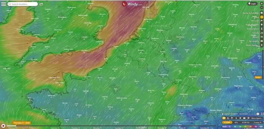
ISA² Programme & ELISE action

   European Interoperability
         Programme                   54 different actions
                                  tackling interoperability
                                    from different angles

  cross-border and cross-sector
    Interoperability solutions
                                  ELISE action is the only
                                  action focusing on the
   for public administrations,      location dimension        European Location Interoperability
     businesses and citizens                                     Solutions for e-Government
                                                                    Enabling Digital Government through
                                                                      Geospatial and Location Intelligence
ISA2                                        ISA2
Welcome to the ELISE webinar series

                                      ELISE Knowledge Transfer
                                              activities

                                      Purpose:
                                      • Engage in an agile way
                                      • with topics of relevance to
                                         the Digital Transformation
                                      • by harnessing the use of
                                         spatial data and technology.
                                      • Share the results of ELISE
                                         activities.

                                        https://europa.eu/!nP74ph
ISA2                           ISA2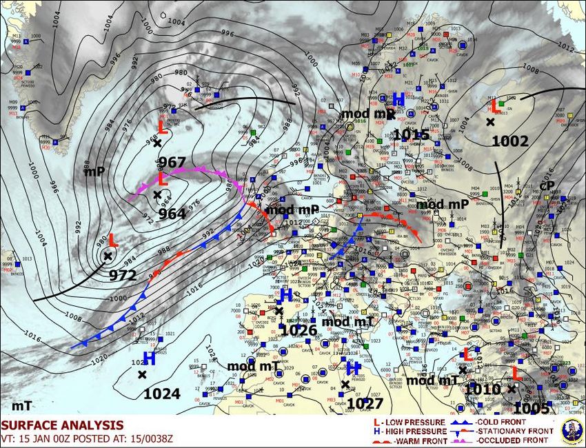
Geospatially
                      enabled
                   Modelling,
                   Simulation
                and Prediction

ISA2
       Forbes
Our speakers

                 Danny                                                   Chris LITTLE
             VANDENBROUCKE                                             (Guest speaker)
                        Senior                                                     UK Met
                      Researcher                                                    Office
                      KU Leuven

       The views expressed are purely those of the authors and may not in any circumstances be regarded as stating an
                                        official position of the European Commission.

                                                            ISA2
What we will cover today
  1. Introduction

     2. Modelling, Simulation and Prediction: some definitions

      3. Modelling: not new to the GIS world

       4. Zooming in on weather forecasting and agent-based modelling

      5. Interoperability efforts and challenges

     6. Key take-away messages and conclusions

  7. Q&A

                                           ISA2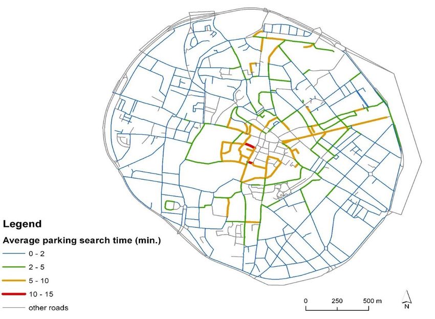
Key messages
   Modelling, simulation and prediction are not
   new, GIS has always been an advanced
   technology to model and simulate, but new
   developments create new challenges and
   opportunities

   Some sectors are more advanced with regard to
   the integration of models, simulations and                                              Analyticssteps.com

   prediction techniques
                                                   Many sectors are evolving towards the integration
                                                   of models, simulation and predictive techniques:
   Specific efforts are needed for reaching         weather and climate, transport and mobility,
   interoperability in modelling, simulation and        health (COVID-19), water and forest
   prediction                                      management, security and disaster management
                                                                           …
Modelling, simulation and
prediction: some definitions
OGC Tech Trends - 2020Q3

      Copyright © 2020 Open Geospatial Consortium
Modelling, simulating, prediction
Different but inter-connected
concepts and related techniques

1. Modeling and Simulation to interact
    with a representation of the real
    world – “prediction” depends on
    user interaction
2. Simulation and Prediction to
    analyze some phenomenology -
    “modeling” establishes the domain
    of analysis
                                OGC (2017)
Simulation
Modelling, simulating, prediction Prediction,
Modelling
Forecasting
1. Modelling - the devising or use of
abstract or mathematical models
2. Simulation - imitation of a situation
or process
• Big data source from meteorological and
physical data
3. Prediction - the action of predicting
• Indexed and analyzed primarily as time-series something in the future (future
information state or behavior)
• Location is “incidental” and primarily 4. Forecasting - predict or estimate (a
important for visualization future event or trend)
Oxford Dictionary (2020)Modelling, simulating, prediction
Different perspectives: Lagrange versus
Eulerian
Britanica.com (2021)
1. Lagrange function, a quantity that
characterizes the state of a physical
system.
2. An Eulerian trail (or path) is a trail in a
finite graph that visits every edge Autonomous cars – basic navigation
exactly once (allowing for revisiting Car is studded with sensors that position the vehicle against a very
precise, pre-determined map, OR
vertices) Car is studded with sensors that observe the surroundings and react
based upon interpretation of those observations
Are you moving through the model or is the Decision tree for interaction with the real world follows the latter
model moving around you ? perspective
OGC (2017)Modelling, simulation and prediction: not new to the GIS world
Modelling, simulation and prediction: not new …
A geographic information system (GIS) is a framework for
gathering, managing, and analyzing data. Rooted in the
science of geography, GIS integrates many types of data.
It analyzes spatial location and organizes layers of
information into visualizations using maps and 3D
scenes. With this unique capability, GIS reveals deeper
insights into data, such as patterns, relationships, and
situations—helping users make smarter decisions.
ESRI (2020)
Flood
GIS GIS technology emerged in the 70-ies
Modelling and evolved gradually into modelling
Traffic Model
engines
ModellingSteady layer, renewed
Modelling, simulation and prediction: not new … every x years based on
new simulations
potentially at risk
NOG – soil data
areas at risk ROG – UAV data
MOG - modelled
POG – policy decisionModelling, simulation and prediction: not new …
This type of modelling has its limitations …
1. GIS and models separate – GIS layers, other
data (e.g. weather data) as input to the model,
output back to GIS
2. Need to regularly run the model, with new
data, because of new human intervention (e.g.
new dykes)
3. From simple ‘models’ (risk assessment based
on a DTM) to more complex ones (integrating
hydrology, hydraulics …)Target
Databases
Modelling, Visual DB
Database
simulation and Source
Phase 1
Data
Synthetic
Creation
Environment
Phase 2
Target Radar DB
prediction: Data Cleaning &
Enhancement
Intermediate
Data
DBs
Generation IR DB
not new … Other Sensors
Standardize here CGF DB
at appropriate
Intermediate stages Maps
Manual Work: 80% 20% Others
Computation Time: 20% 80%
Sogitec and SISO Courtesy Sogitec and SISOZooming in on two examples: weather forecasting and agent- based modelling
Example 1: weather forecasting … www.windy.com
Example 1: weather forecasting …
Example 1: weather forecasting …
It is about complex interrelated phenomena …
                                      Temperature
                                       Pressure
                                       Humidity
                                       Visibility
                                         Cloud
                                         Wind
                                         Snow
                                         Rain
Example 1: weather forecasting … Tropical storms
http://www.wmo.int/pages/prog/www/tcp/index_en.html
Several weather1. Some parameters harder to
forecast(e.g. rain)
Example 1: weather forecasting …
2. The issue of scale is important
3. Dealing with uncertainty
Weather to be factored in in case of volcanic outbreakExample 1: weather forecasting … Towards an integrated approach for hazard prediction, monitoring and risk assessment
Example 2: Agent-based modelling in traffic management                              Axios.com

SUSTAPARK - Tool to provide strategic advice on urban
parking planning, evaluation & simulation
1. Transport & Mobility Leuven
    ➔ Parking aspects
                                           ABM
                                   Agent Based Modelling
2. SADL, K.U. Leuven
    ➔ Spatial model
                                         Drivers spend two days a year
3. Université Libre de Bruxelles         trying to find a parking space -
    ➔ Parking search behavior           and it costs motorists £733 EACH
                                                 in time and fuel
                                                          (Daily Mail, 2017)
                                                                               dailymail.co.uk

                                   toronto.ca
Example 2: Agent-based modelling in traffic management
“Simulating actions and interactions of autonomous
individuals (agents) in a network to predict the actions City of
of complex phenomena” Leuven
(Dieussaert et al., 2009)
Agent = driver
Behaviour Flandertoday.eu
Model = flexible &
dynamic
On transport mode, multi-
mode in the future
JRC, ABM for Smart Grid (2020)Example 2: Agent-based modelling in traffic management
Slideshare.net
Simulation characteristics
1. One day periods
2. Temporal resolution: 1 second Hipwallpaper.com
3. Spatial resolution: street
segment
4. Group of agents representing
driver population
5. Agents’ movement based on
activity schedules Initialization – Agent dataset with activity schedules, network creation
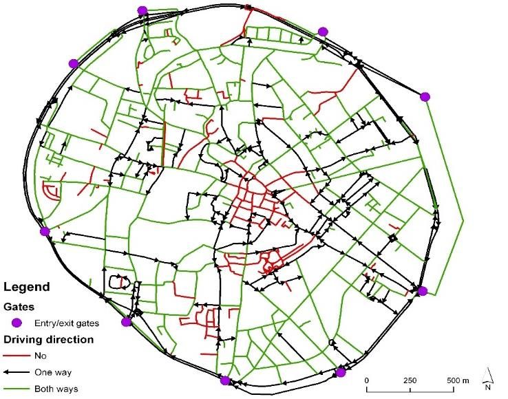
Simulation – Every time step agents’ state & traffic is updatedExample 2: Agent-based modelling in traffic management
Geospatial data
‘Intelligent’ road network
1. Road network (driving direction,
• Cellular automaton (1 cell = speed, hierarchy)
7.5 m) 2. Parking places (private, on-street,
• Single-lane links central parking lots / garages
• Cross roads: modelled as
‘First In, First Out’ Non-spatial data
• Parkings coupled to one cell
• Border: entry/exit gates 1. Activity schedules (local surveys)
Parking places
2. Agent population (local surveys)
Base dataExample 2: Agent-based modelling in traffic management
Agent A 20
18
To work (8:05 // X) 16
To shop (16:40 // Y) 14
12
Home (17:45 // Z) weekday
%
10
weekendday
8
6
4
2
0
0 1 2 3 4 5 6 7 8 9 10 11 12 13 14 15 16 17 18 19 20 21 22 23 24
Dayhour
Search
Strategies
podomatic.com
Utility =
f(d,t,p)
Demand:
Reason
Space / TimeExample 2: Agent-based modelling in traffic management
ABM has been used to plan new (central)
parking spaces, to implement pricing
schemes, etc. Other things could be added
such as integrating other transport networks
(multi-mode), or ecological parameters
Future work could
be on automatic
data collection
(big data)
Rac.co.ukInteroperability efforts and challenges
Standardization activities & Modelling-Simulation-Prediction
Common Data Base                                                  ISO/TC 204
(OGC)
                                                                      ITS
              CDB SWG                     D&I DWG
                          Interoperable
                         Simulation and
                          Gaming DWG                  Hydrology
 OGC Testbeds
                                                        DWG

                         Meteo &
                                           Environmental
                        Ocean DWG                                 OpenMI.org
         WMO                               Data Retrieval
                                             API SWG
OGC Standard used for modelling
There are already several OGC
standards that are used for modelling
and simulation such as WPS, or CDB.
The example shows the eHabitat project
Dubois et al, 2013
eHabitat is a Web Processing Service (WPS)
designed to compute the likelihood of
finding ecosystems with similar conditions
Figure 1: Use of Mahalanobis distances to compute probabilities of finding areas that are ecologically similar to a
reference area, here a protected area in Zambia.OGC OpenMI standard The OpenMI
Association is an
An interface standard (API) for: entirely open not-
for-profit
run time (in memory) data exchange between international group
models, databases & other components of organizations and
Whose purpose is to: people dedicated to
taking the OpenMI
improve ability to model complex scenarios (Open Modelling
Interface) forward
into the future
Application Application
User interface User interface
Input data Input data
Hydraulics Rainfall/Runoff
Output data OpenMI Output dataModel Web Initiative (GEO)
A dynamic web of models, integrated with
databases and websites, to form a consultative
infrastructure where researchers, managers,
policy makers, and the general public can go to
gain insight into “what if” questions
From: Stefano Nativi1 and Gary Geller2
1 (National Research Council of Italy)
2 (NASA JPL)
Part of GEOSS IN-05 component:
GEOSS Design and InteroperabilityKey take-away messages & conclusions
Concluding remarks

The use of modelling, simulation and prediction
techniques is not entirely new to the geospatial world,
GIS has always been used to analyze, model and simulate

Modelling, simulation and prediction is used in many
application domains: climate change, weather
forecasting, transport modelling, spread of pandemic
diseases, environmental and water management …

Several geospatial standards are available or under
development to support modelling, simulation and
prediction activities: OGC but also dedicated initiatives
exist or have seen light recently
Challenges & priorities

                          The growth of huge amounts of data from sensors,
                          satellite imagery … provide new opportunities for
                          more advanced M-S-P; at the same time this is a
                          challenge

                          Recent technological developments (SWE, IoT, …)
                          will make future modelling, simulation and
                          prediction richer and more robust, leading to an
                          improved usability

                          The dedicated initiative to evolve towards a
                          dynamic web of models rather than a web of
                          data/information is promising and should get more
                          attention
Q&A
Thank you

Unless otherwise noted the reuse of this presentation is authorised under the CC BY 4.0 license.

                                                                           ISA2
Stay tuned
Join the ELISE community in JoinUp
@eu_location
eulocation@ec.europa.eu
ELISE playlist
ISA2You can also read