CERT/ENG/140602/4402 LIVERPOOL JOHN LENNON AIRPORT RNAV (GNSS)
←
→
Page content transcription
If your browser does not render page correctly, please read the page content below
LIVERPOOL JOHN LENNON AIRPORT RNAV (GNSS)
                            APPROACHES
                               FRAMEWORK BRIEFING DOCUMENT

                                       CERT/ENG/140602/4402
                                              ISSUE 3

                                                                                          Produced for ATCSL by
                                                                                          Certisa International Ltd
                                                                                          3000 Hillswood Drive
                                                                                          Chertsey
                                                                                          Surrey
                                                                                          KT16 0RS
                                                                                          www.certisa.com

                                                                                          Certisa is ISO9001:2008 certified for the production of
                                                                                          safety assurance documentation by Bureau Veritas

©2015 ATCSL, Certisa. All rights reserved. The information contained within this document must not be disclosed, copied or reproduced in whole
or in part without prior written permission from ATCSL and Certisa. Distribution of this document shall only be as stated in Table 1 unless otherwise
agreed by ATCSL and Certisa.

                  Please consider the environment before printing this document. This document has been formatted to be printed double sided
                  which significantly reduces paper usage and transportation emissions. For full details please see www.certisa.com/environment
Liverpool John Lennon Airport RNAV (GNSS) Approaches
                                                                         Framework Briefing Document

                                      INTENTIONALLY BLANK

Document no: CERT/ENG/140602/4402                                                             Issue 3
Document date: 01-Aug-15
©2016 ATCSL, CIL                    COMMERCIAL IN CONFIDENCE                             Page 2 of 46

Liverpool John Lennon Airport RNAV (GNSS) Approaches
                                                                                                 Framework Briefing Document

Table of Contents
Document Approval ................................................................................................................... 3
Executive Summary .................................................................................................................... 9
1. Project Key Points ............................................................................................................. 10
2. Airspace Change Proposal Requisites ................................................................................ 12
  2.1 Justification for Change ....................................................................................................... 12
     2.1.1 Background .................................................................................................................. 12
     2.1.2 Original Plan for RNAV (GNSS) IAP ............................................................................... 14
     2.1.3 Options Considered...................................................................................................... 15
     2.1.4 Justification for RNAV (GNSS) Baro VNAV .................................................................... 16
  2.2 Design Overview .................................................................................................................. 17
     2.2.1 Design Organisation ..................................................................................................... 17
     2.2.2 Design ........................................................................................................................... 17
     2.2.3 Runway 09 Example ‘Plate’ .......................................................................................... 20
     2.2.4 Runway 27 Example ‘Plate’ .......................................................................................... 21
     2.2.5 Comparison with Existing ILS IAP ................................................................................. 22
     2.2.6 Design Validation.......................................................................................................... 23
  2.3 Preliminary Airspace User Impact Assessment ................................................................... 23
     2.3.1 Airline Operators .......................................................................................................... 23
     2.3.2 General Aviation ........................................................................................................... 24
     2.3.3 Military Aviation ........................................................................................................... 24
     2.3.4 Other Airspace Activity ................................................................................................ 24
  2.4 Environmental Aims and Assumptions................................................................................ 25
  2.5 Initial Assessment of Environmental Implications .............................................................. 26
     2.5.1 Introduction ................................................................................................................. 26
     2.5.2 Track Analysis ............................................................................................................... 26
     2.5.3 In the Airport Vicinity ................................................................................................... 28
     2.5.4 Arriving Traffic .............................................................................................................. 29
     2.5.5 Departing Traffic ........................................................................................................... 30
     2.5.6 Further Afield ............................................................................................................... 30
     2.5.7 General Distribution of Traffic ...................................................................................... 31
     2.5.8 Traffic Forecasts............................................................................................................ 31
     2.5.9 Climate Change ............................................................................................................ 31
     2.5.10 Visual Impact and Tranquillity ...................................................................................... 31
     2.5.11 Air Quality .................................................................................................................... 31
  2.6 Consultation Plan ................................................................................................................ 31
     2.6.1 Overview ...................................................................................................................... 31
     2.6.2 Methodology for Selecting Consultees ........................................................................ 32
     2.6.3 Consultation Information and Format ......................................................................... 32
     2.6.4 Press Release ................................................................................................................ 33
     2.6.5 Consultation Period ...................................................................................................... 33
     2.6.6 Noise and Air Quality Consultants ............................................................................... 33
     2.6.7 Local Authorities .......................................................................................................... 33
     2.6.8 Interest Groups ............................................................................................................ 34

Document no: CERT/ENG/140602/4402                                                                                                      Issue 3
Document date: 01-Aug-15
©2016 ATCSL, CIL                                     COMMERCIAL IN CONFIDENCE                                                    Page 5 of 46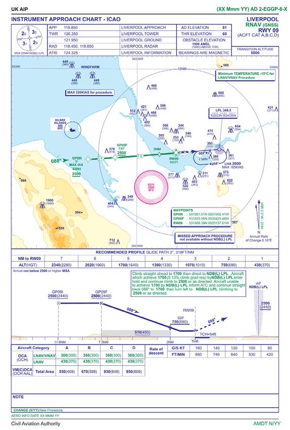
Liverpool John Lennon Airport RNAV (GNSS) Approaches
                                                                                                 Framework Briefing Document

     2.6.9 Neighbouring ATS Units ............................................................................................... 34
     2.6.10 Airline and Air Operators ............................................................................................. 34
     2.6.11 General Aviation ........................................................................................................... 35
     2.6.12 National Air Traffic Management Advisory Committee (NATMAC) ............................. 35
     2.6.13 Full List of Consultees................................................................................................... 35
     2.6.14 Consultation Follow-up ................................................................................................ 36
  2.7 Impact on Arrangements with Adjoining States ................................................................. 37
  2.8 Connectivity to European Airspace Programmes................................................................ 37
     2.8.1 Single European Sky / CAA Future Airspace Strategy .................................................. 37
     2.8.2 Northern Terminal Control Area .................................................................................. 38
  2.9 Proposal Summary .............................................................................................................. 41
     2.9.1 Safety............................................................................................................................ 41
     2.9.2 Airspace Efficiency........................................................................................................ 41
     2.9.3 Airspace Users .............................................................................................................. 41
     2.9.4 Interests of Other Parties ............................................................................................. 42
     2.9.5 Environmental Objectives ............................................................................................ 42
     2.9.6 Integrated Operation of ATS......................................................................................... 42
     2.9.7 National Security .......................................................................................................... 43
     2.9.8 International Obligations ............................................................................................. 43
     2.9.9 Environmental Considerations ..................................................................................... 43
     2.9.10 Consultation ................................................................................................................. 43
3. Annex 1: CAP 670 NAV 07 Compliance ............................................................................... 44
4. Annex 2: CAP 168 Facilities Assessment............................................................................. 46

Figures
Figure 1: Original transition procedure airspace issue ...................................................................... 14
Figure 2: Original procedure environmental issue ............................................................................. 14
Figure 3: Runway 09 lateral design .................................................................................................... 18
Figure 4: Runway 27 lateral design .................................................................................................... 19
Figure 5: Runway movements January to December 2012 ............................................................... 27
Figure 6: Georeferencing / correlation of track data ......................................................................... 28
Figure 7: Radar tracks runway 09 01-Jan-15 to 23-Apr-15................................................................. 29
Figure 8: Radar tracks runway 27 01-Mar-15 to 31-Mar-15 .............................................................. 30
Figure 9: Runway 09 intermediate (dashed) and final segments ...................................................... 34
Figure 10: Runway 27 intermediate (dashed) and final segments .................................................... 34
Figure 11: Proposed NTCA arrival routes to runway 09 ..................................................................... 39
Figure 12: Proposed NTCA arrival routes to runway 27 ..................................................................... 39
Figure 13: Correlation between georeferenced chart and OS coastline............................................ 40

Document no: CERT/ENG/140602/4402                                                                                                      Issue 3
Document date: 01-Aug-15
©2016 ATCSL, CIL                                     COMMERCIAL IN CONFIDENCE                                                    Page 6 of 46
Liverpool John Lennon Airport RNAV (GNSS) Approaches
                                                                          Framework Briefing Document

Acronyms

          ACP                  Airspace Change Proposal
          ANSP                 Air Navigation Service Provider
          ATC                  Air Traffic Control
          ATCB                 Air Traffic Control Building
          CAA                  Civil Aviation Authority
          CAP                  Civil Aviation Publication
          CAT                  Commercial Air Transport
          CCO                  Continuous Climb Operations
          CDA                  Continuous Descent Arrivals
          CTA                  Control Area
          FAF                  Final Approach Fix
          FAT                  Final Approach Track
          FMS                  Flight Management System
          GNSS                 Global Navigation Satellite System
          HAZID                Hazard Identification
          IAP                  Instrument Approach Procedure
          ICAO                 International Civil Aviation Organisation
          IF                   Intermediate Fix
          IFP                  Instrument Flight Procedure
          ILS                  Instrument Landing System
          LJLA                 Liverpool John Lennon Airport
          LNAV                 Lateral Navigation
          LoA                  Letter of Agreement
          NDB                  Non-directional Beacon
          NTCA                 Northern Terminal Control Area
          PANS-OPS             Procedures for Air Navigation Services – Operations
          RESA                 Runway End Safety Area
          RNAV                 Area Navigation
          RWY                  Runway
          SARPS                Standards and Recommended Practices
          SID                  Standard Instrument Departures
          SiS                  Signal in Space
          STAR                 Standard Arrivals
          TMA                  Terminal Manoeuvring Area
          VNAV                 Vertical Navigation

Document no: CERT/ENG/140602/4402                                                              Issue 3
Document date: 01-Aug-15
©2016 ATCSL, CIL                    COMMERCIAL IN CONFIDENCE                              Page 7 of 46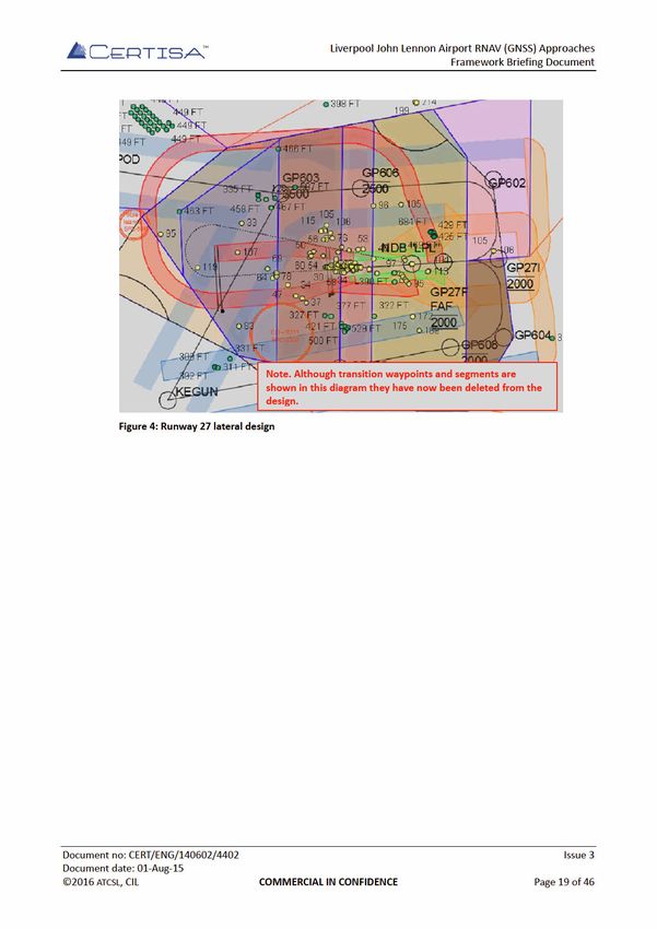
Liverpool John Lennon Airport RNAV (GNSS) Approaches
                                                                          Framework Briefing Document

References
          [1]    CAA Guidance on the Application of the Airspace Change Process, Civil Aviation
                  Authority, document reference CAP 725.
          [2]    Liverpool John Lennon Airport, Airport Master Plan to 2030 Part 1, Peel Airports,
                  2007.
          [3]    Guidance to the Civil Aviation Authority on Environmental Objectives Relating to
                  the Exercise of its Air Navigation Functions, Department of Transport, January
                  2014.
          [4]    Aviation Policy Framework, Secretary of State for Transport, March 2013, ISBN
                  9780101858427.
          [5]    Procedures for Air Navigation Services, Aircraft Operations, Volume 2,
                  Construction of Visual and Instrument Flight Procedures, International Civil
                  Aviation Organisation, document reference 8168 OPS/611.
          [6]    Proposal for PBN Instrument Flight Procedures – Liverpool Airport (EGGP),
                  Davidson Ltd, document reference 20150624EGGP.
          [7]    Liverpool John Lennon Airport Noise Action Plan, LJLA Environment Team, 2013.
          [8]    Guidance to the Civil Aviation Authority on Environmental Objectives Relating to
                  the Exercise of its Air Navigation Functions, Department of Transport, 2014.
          [9]    Future Airspace Strategy Deployment Plan, Level 1, The FAS Industry
                  Implementation Group, December 2012.
          [10]   Liverpool John Lennon Airport RNAV (GNSS) Approaches Safety Case, Certisa
                  International Ltd, document reference CERT/ENG/140602/4301.
          [11]   Guidance on the Conduct of Hazard Identification, Risk Assessment and the
                  Production of Safety Cases: For Aerodrome Operators and Air Traffic Service
                  Providers, Civil Aviation Authority, document reference CAP 760.
          [12]   CAA website, Introduction to Bowtie and Significant Seven Bow-Tie templates
                  www.caa.co.uk/bowtie.
          [13]   Compliance with ICAO SARPS for RNAV GNSS Instrument Approach Procedures
                  supporting LNAV and LNAV/VNAV, Civil Aviation Authority.
          [14]   Liverpool RNAV IAP Minutes of Design Review, Certisa International Ltd, document
                  reference CERT/ENG/140602/8001.
          [15]   Liverpool John Lennon Airport RNAV (GNSS) Approaches Validation Plan and
                  Report, Certisa International Ltd, document reference CERT/ENG/140602/4501.
          [16]   Policy Statement – Validation of Instrument Flight Procedures, CAA Directorate of
                  Airspace Policy, June 2009.

Document no: CERT/ENG/140602/4402                                                              Issue 3
Document date: 01-Aug-15
©2016 ATCSL, CIL                    COMMERCIAL IN CONFIDENCE                              Page 8 of 46
Liverpool John Lennon Airport RNAV (GNSS) Approaches
                                                                              Framework Briefing Document

                                      Executive Summary
Air Traffic Control Services Ltd (ATCSL) are the Air Navigation Service Provider (ANSP) for Liverpool
John Lennon Airport (LJLA). Certisa have been tasked by ATCSL to support the implementation of
new Global Navigation Satellite System (GNSS) based Area Navigation (RNAV) Instrument Approach
Procedures (IAP) for both runways at LJLA.
As the name implies, GNSS IAP use satellite navigation technology to provide aircraft flight path
guidance. This technology reduces the cost of the required ground infrastructure and therefore has
an advantage over conventional, ground-based systems such as Instrument Landing System (ILS) and
Non-directional Beacon (NDB). Furthermore, GNSS RNAV can facilitate more efficient and flexible
use of airspace.
Changes to airspace and flight routings in the UK are governed by the process described in Civil
Aviation Publication (CAP) 725 and changes require the formal submission of an Airspace Change
Proposal (ACP).
An ACP is normally initiated by the ANSP, the airport operator or both. In the ACP process the
initiator is referred to as the ‘sponsor’ of the change. For this project the airport operator – Liverpool
Airport Ltd are sponsoring the change but have delegated the majority of the change process to
ATCSL.
Stage 1 of the ACP is the opportunity of the change sponsor to meet with the Civil Aviation Authority
(CAA) and discuss the change proposal early in the process within a ‘Framework Briefing’. An initial
Framework Briefing took place 28 May 2015, however it was quickly clear that the planned
consultation process was inadequate for the scope of the change. This was because the proposed
transition element of the procedure design would cause a noticeable change to aircraft flight paths.
Following the initial Framework Briefing it was decided to change the scope of the IAP design such
that there is no longer a transition element. The new ‘centreline only’ design will allow Liverpool Air
Traffic Control (ATC) to continue to provide radar vectors to aircraft in a similar way to the existing
IAP meaning that the difference to current flight tracks is minimal. ATCSL have also revised the
proposed consultation process such that it now follows the guidance presented in CAP 725 and
provides the statutory minimum of 12-week consultation period.
This document provides preparatory material for the Framework Briefing. Key points made in this
briefing include:
       ■ A demonstration that the new RNAV approaches replicate as closely as possible the
         designs for the existing ILS IAP and that adverse environmental effects have been
         minimised;
       ■ A robust stakeholder consultation process is planned that includes Local Authorities,
         special interest groups, ATC and airspace users;
       ■ A design has been produced by an Approved Procedure Designer (APD) and is ready for
         review;
       ■ The original designs have been validated by EasyJet in a full-flight simulator. A further
         flyability assessment is planned for the new centreline only design.

Document no: CERT/ENG/140602/4402                                                                   Issue 3
Document date: 01-Aug-15
©2016 ATCSL, CIL                       COMMERCIAL IN CONFIDENCE                                Page 9 of 46
Liverpool John Lennon Airport RNAV (GNSS) Approaches
                                                                           Framework Briefing Document

1.        Project Key Points
1.1       The following table provides a very short overview and some key points about the project.
           Background and           Liverpool currently operates Instrument Landing System (ILS)
           justification for        precision approaches to both ends of a single runway.
           change:                  Airlines and aircraft operators are fitting approach capable
                                    GNSS receivers to their fleets.
                                    There is an emerging global trend to use GNSS as a primary or
                                    secondary instrument approach system.
                                    Any outage of the glidepath or localiser transmitters at LJLA
                                    will result in a non-precision approach with higher minima
                                    and the risk of diversions, holds and delays leading to loss of
                                    revenue and confidence by users.
           Design summary:          Two new Lateral Navigation (LNAV) with Vertical Navigation
                                    (VNAV) GNSS approaches have been proposed. The VNAV
                                    component is based on barometry (Baro VNAV).
                                    Each design begins at its respective IF located 3.4 / 3.5
                                    nautical miles on an extended centreline from the FAF. The
                                    intermediate segment connects the IF and FAF. The RNAV FAF
                                    and final approach segment replicate the ILS FAF and final
                                    approach segment.
           Impact on airspace       The procedures provide an additional option to operators
           users:                   when selecting an instrument approach. The procedures also
                                    provide the ability to continue operations in the event of an
                                    outage of the conventional equipment.
                                    LJLA do not believe that there will be any noticeable negative
                                    impacts on airspace users. However LJLA are very willing to
                                    understand any concerns identified during consultation.
           Environmental aims:      It is a project objective that the environmental impacts
                                    resulting from this change shall be kept to an absolute
                                    minimum.
           Consultation plan:       Stakeholders will be notified of the IAP design and presented
                                    with information explaining the nature of the change and its
                                    effect on traffic flows and patterns.
                                    Consultation will consist of information packs and response
                                    forms. These will be sent to Local Authorities whose areas of
                                    responsibility lay below the intermediate and final approach
                                    segments. Local air operators, adjacent Air Traffic Service
                                    (ATS) units and other aviation groups will also be consulted.
                                    The consultation will run for a 12-week period. LJLA will
                                    carefully consider all stakeholder responses and make
                                    changes or otherwise address any concerns raised.

Document no: CERT/ENG/140602/4402                                                               Issue 3
Document date: 01-Aug-15
©2016 ATCSL, CIL                    COMMERCIAL IN CONFIDENCE                              Page 10 of 46
Liverpool John Lennon Airport RNAV (GNSS) Approaches
Framework Briefing Document
Adjoining States: No impacts are foreseen on airspace arrangements with
adjoining states as a result of this change.
European Airspace Liverpool will be affected by the planned Northern Terminal
Programmes: Control Area (NTCA) airspace change and the implementation
of Continuous Climb Operations (CCO) and Continuous
Descent Arrivals (CDA).
The new LNAV/VNAV procedures may therefore may be
adapted to integrate with new Standard Instrument Arrival
(STAR) procedures.
Status and A preliminary design exists for the RNAV (GNSS) IAP.
comments: A Notification of Intended Airspace Change Proposal or
Procedure Design Activity (form 1916) has been submitted to
the CAA and a Safety Case is being prepared.
1.2 This document has been structured in accordance with the suggested Framework Briefing
contents listed within CAP 725 Stage 1 – Framework Briefing section “Outline Intentions”.
1.3 During the initial Framework Briefing it was commented that a more complete proposal
should be presented prior to the Framework Briefing meeting and this document
attempts to address that comment. It was understood however that this is still an early
part of the ACP process and modifications to some of the contents of this document are
likely.
Document no: CERT/ENG/140602/4402 Issue 3
Document date: 01-Aug-15
©2016 ATCSL, CIL COMMERCIAL IN CONFIDENCE Page 11 of 46Liverpool John Lennon Airport RNAV (GNSS) Approaches
Framework Briefing Document
2. Airspace Change Proposal Requisites
2.1 Justification for Change
2.1.1 Background
2.1.1.1 LJLA is an international airport serving the city of Liverpool and the broader North-West
region of England. LJLA is located 6 nautical miles to the south east of Liverpool city centre
on the northern banks of the Mersey Estuary.
2.1.1.2 The airport’s neighbours include the residential communities of Speke to the north and
Hale Village, within the Borough of Halton, to the east. To the north west, LJLA borders
Liverpool International Business Park (on the site of the former airfield) and the grounds
of Speke Hall which is a National Trust property with a significant number of visitors.
Further to the north are the communities of Garston and Allerton. To the south, between
the runway and the estuary, is agricultural land known as ‘the Oglet’. A new control tower
and radar installation are situated within the Oglet and are accessed separately from the
main site. To the west of the airport and to the south of the Oglet are several kilometres
of unpopulated tidal estuary.
2.1.1.3 LJLA was for a time one of the fastest growing airports in Europe, with passenger numbers
increasing from just under 689,500 in 1997 to just under 5.5 million in 2007. Following
the financial crisis and other pressures, passenger numbers have decreased and now
stand at just under 4 million per annum.
2.1.1.4 The following table provides some basic facts about LJLA.
Aspect Details
Runway dimensions 2285 x 46 metres
Airspace Liverpool Air Traffic Zone (ATZ) 2.5 nautical miles radius
(Class D)
Liverpool Control Zone (CTR) (Class D) (see Figure 1)
Air Traffic Service (ATS) Liverpool Radar/Approach (H24)
Communication Liverpool Tower (H24)
Liverpool Ground (by ATC)
ATIS
Radar Separation Minima 3 nautical miles
Table 1: Background information
Document no: CERT/ENG/140602/4402 Issue 3
Document date: 01-Aug-15
©2016 ATCSL, CIL COMMERCIAL IN CONFIDENCE Page 12 of 46Liverpool John Lennon Airport RNAV (GNSS) Approaches
Framework Briefing Document
2.1.1.5 The following table provides some further statistical information:
Statistic Value
(2014 unless stated)
Terminal Passengers 3.984 million
UK ranking (by passenger numbers) 13
Freight (tonnes) 236
UK ranking (by tonnes freight) 25
Commercial Air Transport Movements 30,789
General Aviation / Other Movements 21,460
Total movements 52,249
Number of instrument approaches runway 09 6,411
Number of instrument approaches runway 27 10,651
Total duration ILS 09 unavailable (excluding 981 minutes
schedule maintenance) (Availability 99.826%)
(Jun 2014 – June 2015)
Total duration ILS 27 unavailable (excluding 15 minutes
schedule maintenance) (Availability 99.997%)
(Jun 2014 – June 2015)
Table 2: Background statistics
2.1.1.6 LJLA is situated 20 nautical miles west of Manchester Airport. With such close proximity
there is inevitably a degree of competition between the two airports. The LJLA Master
Plan (ref. [2]) therefore includes the primary objectives of:
■ Developing the airport to provide affordable access for business and leisure
travellers;
■ Complementing the Port of Liverpool to create opportunities for multimodal freight
transportation.
Consequently, it is important that the LJLA provides a safe, reliable and economically
attractive offering to air operators.
Document no: CERT/ENG/140602/4402 Issue 3
Document date: 01-Aug-15
©2016 ATCSL, CIL COMMERCIAL IN CONFIDENCE Page 13 of 46Liverpool John Lennon Airport RNAV (GNSS) Approaches
Framework Briefing Document
2.1.3 Options Considered
2.1.3.1 Prior to deciding on the proposed RNAV (GNSS) with Barometric Vertical Navigation
(Baro-VNAV) design, LJLA considered a number of different options.
2.1.3.2 The following table summarises the options considered along with a short discussion as
to why they were discounted in favour of the design proposed in this document.
No. Option Discussion
1 Do nothing Some elements of the existing ILS, DME and NDB
navigation aids are approaching the end of their useful
lives.
Therefore, the equipment may suffer from more
frequent or extended periods of unserviceability and
more frequent maintenance interventions.
Such events may impair operational capability LJLA,
potentially resulting in passenger inconvenience,
increased costs for air operators, reduced revenues,
increased fuel burn and CO2 emissions.
2 Implement The original ATC operational requirement was for an
RNAV(GNSS) LNAV ‘overlay’ of the existing NDB procedure.
NDB overlay This option was discounted during an preliminary
consultation with a key airspace user (easyjet) because
a LNAV/VNAV design offers precision guidance and a
lower Decision Altitude (DA).
3 Implement This option was initially the preferred option.
RNAV(GNSS) However, once the design had been completed it
LNAV/VNAV with full became clear that there were some significant
transition drawbacks such as the proximity to Manchester
airspace and a change in nominal flightpaths when
compared with the current situation.
4 Replace all existing This option would require a very significant investment
ILS, DME and NDB by the airport operator and could impact on the ability
equipment to achieve the stated objective (ref. [2]) to provide
affordable access for business and leisure travellers.
Furthermore, this option does not provide the flexibility
of adding a RNAV (GNSS) option or resilience in the
event of maintenance or unserviceability.
5 Implement During the initial airline discussions it was highlighted
RNAV(GNSS) with that easyJet (one of main airlines at LJLA) aircraft are
SBAS VNAV currently Baro-VNAV equipped but not SBAS equipped.
Therefore SBAS is a less preferable option.
Table 3: Options considered
Document no: CERT/ENG/140602/4402 Issue 3
Document date: 01-Aug-15
©2016 ATCSL, CIL COMMERCIAL IN CONFIDENCE Page 15 of 46Liverpool John Lennon Airport RNAV (GNSS) Approaches
Framework Briefing Document
2.1.4 Justification for RNAV (GNSS) Baro VNAV
2.1.4.1 All current IAP at LJLA rely on ground based navigational aids, specifically ILS and NDB. An
increasing number of aircraft are equipped with GNSS based RNAV equipment that allows
Performance Based Navigation (PBN) procedures to be flown.
2.1.4.2 A key advantage of RNAV (GNSS) procedures is that they do not require expensive ground
navigation equipment, but the technology also provides more accurate guidance than
NDB which can potentially lead to improvements in safety.
2.1.4.3 The proposed designs include a VNAV component (Baro-VNAV) which mean that pilots
are provided with vertical and horizontal guidance.
2.1.4.4 For now, LJLA are committed to maintaining the existing ground based navigation aids.
Therefore, the RNAV (GNSS) IAP will be providing an option available to pilots of suitably
equipped aircraft and allow continued operations in the event of ILS unavailability.
2.1.4.5 The CAA is leading the development of a Future Airspace Strategy (FAS) for the UK. A
subpart of the FAS is the development of the Northern Terminal Control Area (NTCA). One
of the key advantages of the NTCA will be the ability for aircraft to perform Continuous
Climb Operations (CCO) and Continuous Descent Operations (CDO), these reduce fuel
burn and CO2 emissions.
2.1.4.6 It is understood that the CDO in the NTCA will be PBN derived (ref. [3]). The proposed
GNSS (RNAV) IAP have the potential to interface to the PBN / CDO STAR that are being
considered as part of the NTCA design. A side-effect of the decision to remove the
transition element of the procedures is that the currently proposed IAP could possibly be
connected to a NTCA STAR without change.
2.1.4.7 In summary, the implementation of the RNAV (GNSS) procedures is justified because:
■ Adding RNAV (GNSS) IAP provides greater flexibility to airspace users;
■ RNAV (GNSS) provides a contingency for occasions when the ground based
navigation aids are unavailable;
■ RNAV (GNSS) is more accurate than older NDB technology. When combined with
Baro-VNAV, RNAV (GNSS) IAP provide both lateral and vertical guidance to pilots.
2.1.4.8 Furthermore, the implementation of the RNAV (GNSS) at Liverpool is consistent with the
FAS strategy because it:
■ Is aligned with the UK/Ireland Functional Airspace Block (FAB) aspirations of
developing P-RNAV and progressing to Advanced Required Navigational
Performance (A-RNP);
■ Reduces reliance on ground-based navigation aids;
■ Supports the development of (A-)RNP arrival procedures;
■ Supports the development of requirements for Precision Approach Landing.
Document no: CERT/ENG/140602/4402 Issue 3
Document date: 01-Aug-15
©2016 ATCSL, CIL COMMERCIAL IN CONFIDENCE Page 16 of 46Liverpool John Lennon Airport RNAV (GNSS) Approaches
Framework Briefing Document
2.2 Design Overview
2.2.1 Design Organisation
2.2.1.1 The RNAV (GNSS) IAP have been designed Davidson Ltd who are a CAA approved
Instrument Flight Procedure (IFP) design organisation.
2.2.1.2 Contact details for the IFP designer and design organisation are as follows:
2.2.1.3
2.2.2 Design
2.2.2.1 This section is a short summary of the detailed design description provided in the IFP
designer’s Final Report (ref. [6]).
2.2.2.2 The basic operational requirement for the design was to develop LNAV and LNAV/VNAV
IAP for runways 09 and 27 at Liverpool which replicate as far as possible the existing
approach procedures, but to remain in accordance with the criteria detailed in ICAO Doc
8168 PANS-OPS Volume 2 (ref. [5]).
2.2.2.3 The design was based on the following data:
■ Aerodrome obstacle survey data and threshold co-ordinates provided by Paul
Fassam Geomatics;
■ Aeronautical data extracted from the UK Aeronautical Information Package (AIP);
■ Topographical data extracted from Ordnance Survey Open Data;
All co-ordinates used in the design were based on data provided by Paul Fassam
Geomatics and the UK AIP.
2.2.2.4 The nominal tracks in the initial proposal for approaches to runways 09 and 27 can be
seen at Figure 1. The entry points were established at TIPOD and KEGUN with a slightly
modified ‘T-bar’ approach to runway 09 and downwind legs connecting the entry points
with the classic T-bar to runway 27.
Document no: CERT/ENG/140602/4402 Issue 3
Document date: 01-Aug-15
©2016 ATCSL, CIL COMMERCIAL IN CONFIDENCE Page 17 of 46Liverpool John Lennon Airport RNAV (GNSS) Approaches
Framework Briefing Document
2.2.3 Runway 09 Example ‘Plate’
Document no: CERT/ENG/140602/4402 Issue 3
Document date: 01-Aug-15
©2016 ATCSL, CIL COMMERCIAL IN CONFIDENCE Page 20 of 46Liverpool John Lennon Airport RNAV (GNSS) Approaches
Framework Briefing Document
2.2.4 Runway 27 Example ‘Plate’
Document no: CERT/ENG/140602/4402 Issue 3
Document date: 01-Aug-15
©2016 ATCSL, CIL COMMERCIAL IN CONFIDENCE Page 21 of 46Liverpool John Lennon Airport RNAV (GNSS) Approaches
Framework Briefing Document
2.2.5 Comparison with Existing ILS IAP
The following tables provide a comparison of key elements between the new RNAV (GNSS) IAP and the
existing ILS IAP.
Runway 09
Element RNAV (GNSS) IAP ILS IAP
STAR to IAP transition ATC radar vectors to IF or to ATC radar vectors to intercept
(normal operations) intercept extended centreline extended centreline
IF bearing to THR 088°M (extended centreline) N/A
IF distance to THR 10.9 nautical miles N/A
IF altitude 2500 feet AMSL N/A
FAF bearing to THR 088°M (extended centreline) 088°M (extended centreline)
FAF distance to THR 7.5 nautical miles 7.5 nautical miles
FAF altitude 2500’ AMSL 2500’ AMSL
GP gradient 3° 3°
OCA 360’ (CAT A – D) 205’ (CAT A) / 241’ (CAT D)
Missed approach Straight ahead to LPL climbing Straight ahead to LPL climbing
2500’ 2500’
Table 4: Comparison between RNAV and ILS IAP runway 09
Runway 27
Element RNAV (GNSS) IAP ILS IAP
STAR to IAP transition ATC radar vectors to intercept ATC radar vectors to intercept
(normal operations) extended centreline extended centreline
IF bearing to THR 268°M (extended centreline) N/A
IF distance to THR 9.4 nautical miles N/A
IF altitude 2000 feet AMSL N/A
FAF bearing to THR 268°M (extended centreline) 268°M (extended centreline)
FAF distance to THR 5.9 nautical miles 5.9 nautical miles
FAF altitude 2000’ AMSL 2000’ AMSL
GP gradient 3° 3°
OCA 390’ (CAT A – D) 229’ (CAT A) / 263’ (CAT D)
Missed approach Straight ahead to 1500’ then Straight ahead to 1500’ then
right to LPL climbing 2000’ right to LPL climbing 2000’
Table 5: Comparison between RNAV and ILS IAP runway 27
Document no: CERT/ENG/140602/4402 Issue 3
Document date: 01-Aug-15
©2016 ATCSL, CIL COMMERCIAL IN CONFIDENCE Page 22 of 46Liverpool John Lennon Airport RNAV (GNSS) Approaches
Framework Briefing Document
2.2.6 Design Validation
2.2.6.1 A full flight validation process was conducted for the original RNAV 09, RNAV 27 and
RNAV 27 alternate procedures (including transitions) on 17 February 2015. The validation
was conducted in accordance with the Validation Plan and Results (ref. [15]) which has
been prepared to satisfy the requirements of the CAA Policy Statement on the Validation
of Instrument Flight Procedures (ref. [16]).
2.2.6.2 The validation was performed by EasyJet / CAE using a full motion A320 simulator. In order
to realistically evaluate the procedure a special database was encoded for the simulator’s
Honeywell Flight Management System (FMS).
2.2.6.3 Overall the procedure design was given the maximum score of 9 out of 9 against the
criteria of “General impression of the procedure”. There were no adverse observations
and only three comments. Two of the comments related to the initial / transition
segments of the procedure and are therefore no longer relevant. The remaining comment
relates to the hold design as follows:
“The hold speed of 185 kts at LPL Non-directional Beacon (NDB) requires holding with slats
extended on an A320 which leads to higher fuel consumption. Airbus recommends that
slats are not extended during holding in icing conditions. It is recommended that the hold
is reviewed.”
2.2.6.4 The EasyJet evaluation was based on the full procedure, however it has been agreed with
SARG that the results of this evaluation are acceptable for the centreline only designs.
EasyJet have also confirmed that their aircraft equipment is able to ‘capture’ a GNSS
approach profile from a radar vectored intercept.
2.2.6.5 The hold is based on the existing hold for the ILS and NDB approaches. It is of course
possible to design a new hold for the RNAV procedures, but this hold is only practically
used in the event of a radio failure. LJLA would like to avoid a change that may result in
any negative environmental impact. The hold design has subsequently been discussed
and accepted by easyJet.
2.2.6.6 A further validation assessment is planned to be conducted by Ravenair in a PA-34 Seneca
light twin-engine aircraft. The assessment will also be conducted in accordance with the
documented Validation Plan. The primary objective of the Ravenair assessment is to
establish the controllability and flyability of radar vectoring to intercept the IAF – FAF
segment. The flights will also validate the flyability of the procedure in a GA aircraft and
visually validate obstacle and terrain clearance.
2.3 Preliminary Airspace User Impact Assessment
2.3.1 Airline Operators
2.3.1.1 The implementation of the RNAV (GNSS) IAP has been requested by airlines that currently
operate at Liverpool, in particular easyJet and Ryanair. These airlines have been involved
in the decision process since the early stages and have been instrumental in selecting a
VNAV and centreline only option.
Document no: CERT/ENG/140602/4402 Issue 3
Document date: 01-Aug-15
©2016 ATCSL, CIL COMMERCIAL IN CONFIDENCE Page 23 of 46Liverpool John Lennon Airport RNAV (GNSS) Approaches
Framework Briefing Document
2.3.1.2 One impact may be that an airline which is not GNSS / Baro VNAV equipped could be
conceivably disadvantaged against those that are, especially if maintaining ILS / NDB
serviceability is given a lower priority. However LJLA have stated that this will not happen
as they are committed to keeping the existing navaids in operation. Furthermore, RNAV
(GNSS) IAP are becoming increasingly commonplace throughout Europe so an airline that
is not equipped would be generally disadvantaged in any case. A fuller picture of which
airlines are RNAV(GNSS) Baro-VNAV equipped is expected to emerge during the
consultation.
2.3.1.3 With the exception of the above, it is difficult to identify further adverse impacts at this
stage on airline operators resulting from the change.
2.3.2 General Aviation
2.3.2.1 It was discussed early in the design considerations that GA aircraft are more likely to be
equipped with Space Based Augmentation System (SBAS) VNAV equipment than the
airlines. This means that GA operators may not benefit from the full advantages of the
Baro-VNAV designs.
2.3.2.2 The proposed change includes both LNAV/VNAV and LNAV designs, so GNSS equipped GA
aircraft will still be able to use the new procedures for a non-precision approach.
2.3.2.3 The airport operator has committed to maintaining the existing ground based navaids for
the immediate future. Therefore, there will normally be little detrimental when compared
to the current situation unless there is a significant rise in the unavailability of the ILS.
2.3.3 Military Aviation
2.3.3.1 There were 348 military movements at LJLA in 2014. This represents less than 1% of total
movements.
2.3.3.2 As with GA, the only detrimental impact of this change would be if the airport operator
attaches less importance to the availability of the ground based navaids, however this is
not intended to be the case.
2.3.4 Other Airspace Activity
2.3.4.1 It is not foreseen that this change will have any impact on airspace users outside of the
Liverpool CTR. The centreline only design is contained completely within airspace
delegated to Liverpool.
2.3.4.2 There is no significant increase in traffic forecast by LJLA as a result of the change.
Therefore, it is difficult to identify any impact on airspace users other than those already
discussed.
Document no: CERT/ENG/140602/4402 Issue 3
Document date: 01-Aug-15
©2016 ATCSL, CIL COMMERCIAL IN CONFIDENCE Page 24 of 46Liverpool John Lennon Airport RNAV (GNSS) Approaches
Framework Briefing Document
2.4 Environmental Aims and Assumptions
2.4.1 LJLA takes their statutory and social responsibilities very seriously and has published a
43-page Noise Action Plan (ref. [7]) in 2013. To comply with the Noise Action Plan, it has
always been a core objective of this project that adverse environmental impacts resulting
from the change shall be kept to an absolute minimum and that every opportunity should
be taken to reduce environmental noise and pollution.
2.4.2 To meet this objective, the original transition design attempted to replicate the mean flow
of existing flight tracks, however in order to meet PANS-OPS criteria the design required
an IF that is further from the FAF than the current radar vectored ILS intercepts. The fact
that this could result in a shift in noise footprint as well as increased fuel burn / CO2
emissions was central to the decision not to implement the full design.
2.4.3 It is assumed that there will be no significant increase in air traffic as a direct result of the
change. This assumption is justified as follows:
■ The airport operator has committed to maintain the ILS and NDB in service for the
time being. Most commercial aircraft will be equipped with ILS and NDB receivers
for the foreseeable future, therefore it is unlikely that a commercial operator would
choose Liverpool purely on the basis that RNAV (GNSS) is available;
■ An aircraft arrival may be made possible using the RNAV (GNSS) IAP that otherwise
would not be achievable if the ILS was unavailable. However, it is also conceivable
that a NDB approach may have been attempted resulting in a missed approach and
diversion. Such a manoeuvre would give rise to significantly greater noise / fuel burn
/ CO2 emissions than a successful RNAV approach;
■ There might be a slight increase in General Aviation (GA) aircraft flying practice
RNAV (GNSS) procedures. It is thought that this will have a minimal effect due to the
significantly lower fuel burn / emissions of light aircraft. (GNSS) IAP are becoming
increasingly widespread so Liverpool would be only one of a number of possible
options for training.
Document no: CERT/ENG/140602/4402 Issue 3
Document date: 01-Aug-15
©2016 ATCSL, CIL COMMERCIAL IN CONFIDENCE Page 25 of 46Liverpool John Lennon Airport RNAV (GNSS) Approaches
Framework Briefing Document
2.5 Initial Assessment of Environmental Implications
2.5.1 Introduction
2.5.1.1 The CAA requires sponsors of airspace changes to take due regard for the need to reduce,
control and mitigate as far as possible the environmental impacts of aircraft operations,
including disturbance caused to the general public arising from aircraft noise and
emissions from aircraft engines.
2.5.1.2 The new RNAV (GNSS) IAP have been designed with the explicit criteria that changes to
existing aircraft routings should be kept to an absolute minimum and that there should
be no changes to noise abatement procedures.
2.5.1.3 In the short term the introduction of the RNAV (GNSS) IAP has the potential to lower fuel
burn and CO2 emissions by reducing the likelihood of aircraft making missed approaches,
diverting or holding. It is difficult to quantitatively estimate the net effects, which are in
any case relatively small due to the low number of missed approaches and/or diversions
at Liverpool. However, the following should be considered:
■ For an Airbus A320, one missed approach, diversion to Manchester (without
holding) followed by a later repositioning of the aircraft back to Liverpool can use up
to 3 tonnes of fuel and a corresponding increase in CO2 emissions;
■ An aircraft diversion represents disruption for travellers and a significant financial
cost for an airline, potentially running to tens of thousands of pounds;
■ The mean number of arrivals by aircraft with more than 100 passenger seats is
approximately 38 per 24 hours.
Liverpool ATC are investigating whether it is possible to provide data on diversions and
holding times to further assess the above.
2.5.2 Track Analysis
2.5.2.1 LJLA has invested in a Brüel and Kjær (B&K) Noise Monitoring and Track Keeping System
(NM&TKS). This system enables the airport to accurately the record and monitor the
altitude, position, aircraft type and noise generated by each aircraft movement. LJLA has
an annual contract with the NM&TKS suppliers to ensure that the equipment remains
calibrated.
2.5.2.2 The NM&TKS collects information from three main sources:
■ Noise data from the Noise Monitoring Terminals (NMT) at Hale, Eastham and a
mobile site. The noise data is correlated with aircraft track data to identify specific
aircraft noise events;
■ Secondary Surveillance Radar (SSR) from NATS at Manchester Airport provides
information about the position, altitude and speed of aircraft near LJLA. This
enables specific aircraft movements to be identified, their altitude at a specific time
to be established and a noise event at one of the NMTs to be correlated;
■ The Airport’s Operation Database (AMOSS) provides information about the aircraft
using LJLA such as the aircraft type, airline, origin or destination. This information
can be correlated with the track data to make the information easier to interpret.
Document no: CERT/ENG/140602/4402 Issue 3
Document date: 01-Aug-15
©2016 ATCSL, CIL COMMERCIAL IN CONFIDENCE Page 26 of 46Liverpool John Lennon Airport RNAV (GNSS) Approaches
Framework Briefing Document
2.5.2.3 Two sets of data were extracted from the NM&TKS to allow evaluation of the existing
mean aircraft track paths. The first set is comprised of Commercial Air Transport (CAT) IFR
aircraft inbound to LJLA runway 09 between 1 January and 23 April 2015. The second set
is comprised of CAT IFR aircraft inbound to LJLA runway 27 between 1 March and 31
March 2015. The larger time span was needed for runway 09 tracks because the prevailing
winds at LJLA are westerlies and therefore runway 09 usage is significantly less (see Figure
5).
2.5.2.4 The B&K NM&TKS overlays the recorded track data on a standard Ordnance Survey of
Great Britain (OSGB) topographical map, the result is then output as a Portable Document
Format (PDF) file.
Figure 5: Runway movements January to December 2012
2.5.2.5 In order to correlate the recorded track data with the procedure design a Geographic
Information System (GIS) tool was used. The NM&TKS PDF file was georeferenced using
the Easting / Northing grid printed on the OS topographical map and then re-projected
using the British National Grid / OSGB 1936 Coordinate Reference System (CRS). OSGB
1936 was used because it is the same CRS that is used for the procedure design files.
2.5.2.6 To confirm that the plots have been correctly georeferenced, the OSGB 10 kilometre grid
and the OSGB high water coastline file were also imported into the GIS tool. The following
image shows that the georeferencing of the track data PDF was suitably accurate.
Document no: CERT/ENG/140602/4402 Issue 3
Document date: 01-Aug-15
©2016 ATCSL, CIL COMMERCIAL IN CONFIDENCE Page 27 of 46Liverpool John Lennon Airport RNAV (GNSS) Approaches
Framework Briefing Document
2.5.7 General Distribution of Traffic
2.5.7.1 Aircraft that are using the RNAV (GNSS) IAP will be affected in the ways described in the
preceding paragraphs.
2.5.7.2 The distribution of aircraft should not otherwise be discernibly affected by this change.
2.5.8 Traffic Forecasts
2.5.8.1 The change sponsors have not identified any quantifiable increase in traffic as a result of
this change. Therefore, no revision to the current overall traffic forecasts has been made
at this time.
2.5.8.2 Potential users of the RNAV (GNSS) IAP will be canvassed on their anticipated use of the
new procedures. A quantitative estimate for the use of the new procedures will be
provided as part of the final operational and environmental reports.
2.5.9 Climate Change
2.5.9.1 As described in the introduction to this section on page 26, it is not anticipated that there
will be any negative impacts on fuel burn or CO2 emissions.
2.5.9.2 The implementation for the RNAV (GNSS) IAP has the potential to reduce the number of
weather related missed approaches and diversions.
2.5.10 Visual Impact and Tranquillity
2.5.10.1 If the runway 09 IF is used regularly as a waypoint, the reduction of deviations along the
intermediate segment may have a net effect of reducing visual impact and increasing
tranquillity for those who were affected by the broader swathes. However, it is impossible
to quantify at this stage because it is not known how many aircraft will use the new
procedures until after the consultation takes place.
2.5.10.2 A Noise and Air Quality Report has been commissioned by LJLA. Bickerdike Allen
Partnership, who are experts in the field, are writing the environmental noise section.
2.5.11 Air Quality
A Noise and Air Quality Report has been commissioned by LJLA. Air Quality Consultants
Ltd, who are experts in the field, are writing the air quality section. A copy of the Noise
and Air Quality Report will be attached to the final Environmental Report submission.
2.6 Consultation Plan
2.6.1 Overview
2.6.1.1 This section sets out the rationale and methodology for the consultation process that will
be undertaken by LJLA. It is intended to be a live communication vehicle between the
consultation team and the regulator.
2.6.1.2 The primary scope of the consultation is to inform local stakeholders of the change. LJLA
also plan to use the consultation as an opportunity to explain that:
Document no: CERT/ENG/140602/4402 Issue 3
Document date: 01-Aug-15
©2016 ATCSL, CIL COMMERCIAL IN CONFIDENCE Page 31 of 46Liverpool John Lennon Airport RNAV (GNSS) Approaches
Framework Briefing Document
■ There is no change to the current forecast for commercial traffic levels, however it is
considered that some additional GA aircraft may choose to use Liverpool because of
the new procedures;
■ Any increases in exposure to noise are planned to be minimal;
■ Any impacts on fuel burn and CO2 emissions are planned to be minimal;
■ There should not be any measurable change to local air quality.
2.6.1.3 A comprehensive safety case is being developed for the new IAP. Consultation on air safety
matters will take place during the Hazard and Operability Study (HAZOP) and risk
assessment process.
2.6.2 Methodology for Selecting Consultees
2.6.2.1 Consultees have been selected based upon the following criteria:
■ A person, group or organisation that represents those who may be environmentally
affected by the introduction of the new IAP;
■ A person, group or organisation that represents those whose operational activities
may be affected by the introduction of the new IAP;
■ A person, group or organisation that represents potential users of the new IAP.
2.6.2.2 Sections 2.6.7 to 2.6.12 below identify specific consultees in accordance with the above
selection criteria and describe the consultation actions for each group.
2.6.3 Consultation Information and Format
2.6.3.1 Consultees are to be provided with a consultation pack containing:
■ A covering letter;
■ A professionally produced, brochure style information document of 8 pages. The
document explains in layman’s terms what an RNAV (GNSS) approach is, details of
the designs being proposed at LJLA and why there will be only a very minor
difference to aircraft flight paths and heights as a result of their introduction;
■ A response form.
2.6.3.2 An early draft (not yet typeset) of the information document and proposed response form
is attached (Attachment A).
2.6.3.3 Four ‘drop in’ consultation sessions have been arranged as follows:
■ Wednesday 19th August 2015 (10:00 to 12:00);
■ Saturday 5th September 2015 (10:00 to 12:00);
■ Monday 14th September 2015 (17:00 to 19:00);
■ Friday 9th October 2015 (14:00 to 16:00).
These have been deliberately scheduled on different days of the week and at different
times of day to make it as practical as possible for interested parties to attend.
Document no: CERT/ENG/140602/4402 Issue 3
Document date: 01-Aug-15
©2016 ATCSL, CIL COMMERCIAL IN CONFIDENCE Page 32 of 46Liverpool John Lennon Airport RNAV (GNSS) Approaches
Framework Briefing Document
2.6.3.4 A consultation web page is being created on the LJLA website. As well as providing an
overview of the change and consultation process, visitors will be able to download the
information document and response form.
2.6.3.5 A bespoke email address and voicemail box
will be arranged. These will provide further options for consultees to
communicate their thoughts and opinions on the proposal. The email address and
telephone number will be clearly presented in the information document and on the
consultation web page.
2.6.4 Press Release
A press release has been issued on 22 July 2015 and has been sent to the following media
outlets:
2.6.5 Consultation Period
2.6.5.1 The consultation period is commenced on the 22 July 2015 and will run for 12 weeks until
14 October 2015.
2.6.5.2 The period launched with consultation being made available on the airport’s website. The
website has a page dedicated to the change with an invitation for visitors to download
the information document and response form.
2.6.5.3 Hard copy consultation packs were also be sent out shortly after the 22 July 2015 to the
named stakeholders.
2.6.6 Noise and Air Quality Consultants
2.6.6.1 LJLA has asked Bickerdike Allen Partners (BAP) and Air Quality Consultants (AQC) to review
the proposed procedures. Both companies are independent experts in their respective
fields of environmental noise and air pollution. A short Noise and Air Quality Report has
been commissioned, an overview of which will be presented in the information
document.
2.6.6.2 LJLA believe that the change in the effects of noise and air quality will be hardly discernible
as a result of the introduction of the new procedures. It is expected that the report will
either validate that belief or indicate that the proposed design needs reassessment from
an environmental perspective.
2.6.7 Local Authorities
2.6.7.1 Six Local Authorities have the theoretical potential to be affected by the changes.
2.6.7.2 The following two diagrams show the intermediate and final segments for runway 09 and
runway 27 overlaying a map of the local authority areas. The runway is shown with red
dashes.
Document no: CERT/ENG/140602/4402 Issue 3
Document date: 01-Aug-15
©2016 ATCSL, CIL COMMERCIAL IN CONFIDENCE Page 33 of 46Liverpool John Lennon Airport RNAV (GNSS) Approaches
Framework Briefing Document
Contains OS data © Crown copyright 2015 Contains OS data © Crown copyright 2015
Figure 9: Runway 09 intermediate (dashed) and final Figure 10: Runway 27 intermediate (dashed) and final
segments segments
2.6.7.3 Each Local Authority will be provided with a consultation pack and face-to-face meetings
are to be scheduled for each authority. These meetings will be an opportunity to discuss
all aspects of the RNAV IAP introduction.
2.6.8 Interest Groups
2.6.8.1 Members of the Liverpool Airport Consultative Committee (ACC) will be sent a copy of the
consultation pack. A presentation on the new procedures will be given at the regular ACC
meeting on 11 September 2015.
2.6.8.2 The Noise Monitoring Subgroup (NMS) is a subgroup of the ACC and its members will also
be sent the consultation pack. A presentation on the new procedures will be given at the
regular NMS meeting on 17 July 2015, assuming that the consultation process is agreed
with the CAA.
2.6.9 Neighbouring ATS Units
2.6.9.1 A consultation pack will be sent to the two Air Traffic Service Units (ATSU) whose areas of
interest adjoin Liverpool airspace and the Air Traffic Control Centre (ATCC) that provides
the area service to Liverpool.
2.6.9.2 Each unit will be telephoned or emailed after approximately one week to confirm they
have received the consultation pack and again approximately two weeks before the end
of the consultation period.
2.6.10 Airline and Air Operators
2.6.10.1 A consultation pack will be sent to based operators. Based operators were invited to
attend a Hazard Identification (HAZID) workshop on 8 July 2015.
2.6.10.2 Each operator will be either telephoned or emailed after approximately one week to
confirm they have received the consultation pack. They will be contacted again
approximately two weeks before the end of the consultation period.
Document no: CERT/ENG/140602/4402 Issue 3
Document date: 01-Aug-15
©2016 ATCSL, CIL COMMERCIAL IN CONFIDENCE Page 34 of 46You can also read