Chelmsford City Growth Package - Army & Navy Improvement: Baddow Road Bus Gate - Design Stage 2 Report - Essex Highways
←
→
Page content transcription
If your browser does not render page correctly, please read the page content below
Chelmsford City Growth Package
Army & Navy Improvement: Baddow Road Bus
Gate – Design Stage 2 Report
21st December 2017
Document Control Sheet

Document prepared by:

 Essex Highways                  E    ChelmsfordGrowthPackage@jacobs.com
 Transport Planning              W    www.essex.gov.uk/highways
 Victoria House
 Chelmsford
 CM1 1JR

Record of Issue
                                                                    PM
               Status   Author       Date    Check        Date                       Date
                                                                  Approval
     1         Draft    CR/MA    01/12/17     JJ/CC    06/12/17     CC            07/12/17
     2         Final      CR     18/12/17     JJ/CC    20/12/17     CC            21/12/17

Distribution

         Organisation                        Contact                         Number of Copies
 Essex County Council      Strategy and Engagement Team                 Electronic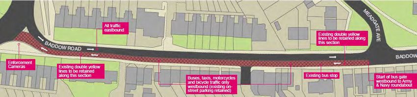
Contents page
1 Introduction ................................................................................................................................................... 4
    1.1 Purpose of the report .............................................................................................................................. 4
    1.2        Option Origin ..................................................................................................................................... 4
2 VISSIM model review/update of Mouchel 2010 reports (2016) .................................................................. 9
    2.1 Review of Problems and Issues (2016)................................................................................................... 9
    2.2 Review of Modelling (2016) ................................................................................................................. 10
    2.3 Meadgate Bus Gate Option ................................................................................................................... 13
    2.4 Potential mitigation............................................................................................................................... 14
    2.5 Trial Period ............................................................................................................................................ 15
3 Public Consultation ....................................................................................................................................... 15
    3.1 Description of preferred option presented at consultation ................................................................. 16
4 Consultation Outputs ................................................................................................................................... 18
5       Revised Preferred Option ....................................................................................................................... 20
    5.1       Reasoning ........................................................................................................................................ 20
    5.2 Air Quality Modelling ........................................................................................................................... 21
6       Report Summary ..................................................................................................................................... 22
Appendix 1 – 5 DaSTS goals ............................................................................................................................. 25
Appendix 2 – Data for 2016 update ................................................................................................................ 26
Appendix 3 – Invidual Consultation Comments – Baddow Road .................................................................... 35
Appendix 4 – Stakeholder and Group Consultation Comments – Baddow Road ........................................... 40
Appendix 5 – Scheme drawings ....................................................................................................................... 44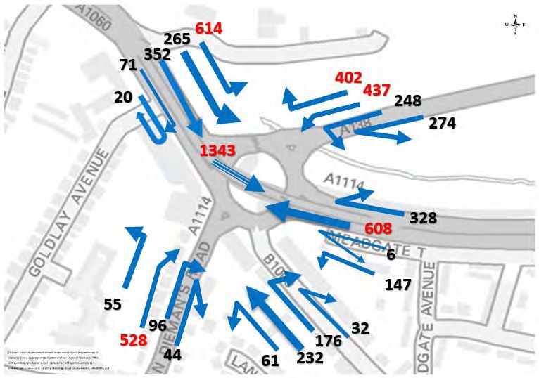
1 Introduction
1.1 Purpose of the report
Essex County Council (ECC) have been allocated £10m by the South-East Local Enterprise
Partnership (SE LEP) in addition to an ECC contribution of £5m to deliver a range of transport
improvement measures under the Chelmsford City Growth Package. Essex County Council have
commissioned Essex Highways to identify the components of the overall package and develop each
individual scheme in alignment with the ECC Contract Manual ready for construction of the preferred
option during 2018-21.
The Army and Navy / Baddow Road bus gate was put forward as an improvement scheme proposed
for the Army & Navy roundabout and is one of a number of transport improvement schemes which
have been prioritised for inclusion in this package. This scheme was included based on outputs
from the strategic and operational modelling in the 2010 Army & Navy Long Term Options study by
Mouchel. This ranked the Baddow Road bus gate proposal in the top two of seven options assessed.
The Baddow Road bus gate option has since been re-modelled using a combination of the more
recently developed 2014 Chelmsford strategic VISUM model and 2014 Chelmsford micro-simulation
VISSIM model in order to compare outputs with those of the previous more detailed study.
1.2 Option Origin
The Chelmsford City Growth Package option for an improvement scheme at the Army and Navy /
Baddow Road was selected based on the findings from two Mouchel studies completed in 2010.
The full studies can be found in the following reports:
Army & Navy Roundabout – Modelling of Long Term Measures – Mouchel August 2010
Baddow Road Closure Study – Modelling Report – Mouchel August 2010
A brief summary of these reports and the findings are detailed below.
The Army & Navy Roundabout – Modelling of Long Term Options study by Mouchel 2010
This study was commisioned to review long term measures to improve the Army and Navy junction
for all users (motor vehicles, public transport, cyclists and pedestrians). Problems identified at the
junction included:
AQMA area at the junction and spreading along Baddow Road
Significant queuing on all arms during the peak hours
Five arm roundabout is more challenging to mitigate through signals due to proximity of arms
to each other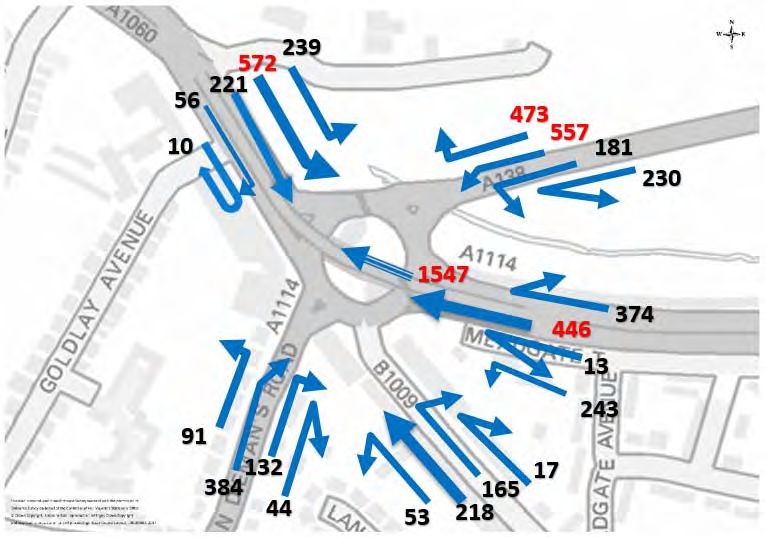
Significant delays to buses along the Baddow Road corridor
Lack of provision for cyclists
Lack of high quality provision for pedestrians
Mouchel and ECC developed seven potential improvement options to be modelled at the Army &
Navy junction, each of which was modelled in strategic modelling software SATURN/DIADEM for
2021 in order to forecast future traffic flows at the Army and Navy junction and the surrounding area
by the end of the LDF (Local Development Framework) period. Operational models in
TRANSYT/ARCADY were used to assess the localised operation of the junction itself. The options
modelled were as follows;
Two-way flyover (between A1114 and Parkway) with existing roundabout
Two-way flyover (between A1114 and Parkway) with signal control on one or more
approaches to the roundabout
Tidal flyover (AM inbound and PM outbound) with signal control on one or more
approaches to the roundabout
Revised signalised junction (gyratory) without flyover
Bus Gate on Baddow Road inbound with existing roundabout and tidal flyover
A two-way Bus Gate on Baddow Road with existing roundabout and tidal flyover
Removal of the existing flyover (between A1114 and Parkway) with existing
roundabout
Each of the seven 2021 options was ranked in terms of overall performance against the DfT’s
Delivering a Sustainable Transport System (DaSTS) criteria below (further details shown in
Appendix 1) in comparison to the Do-Minimum scenario, across the AM and PM peak hours. The
overall rankings are shown in the table below:
DaSTS Criteria (full detail in Appendix 1):
• Supporting National Economic Competitiveness and Growth;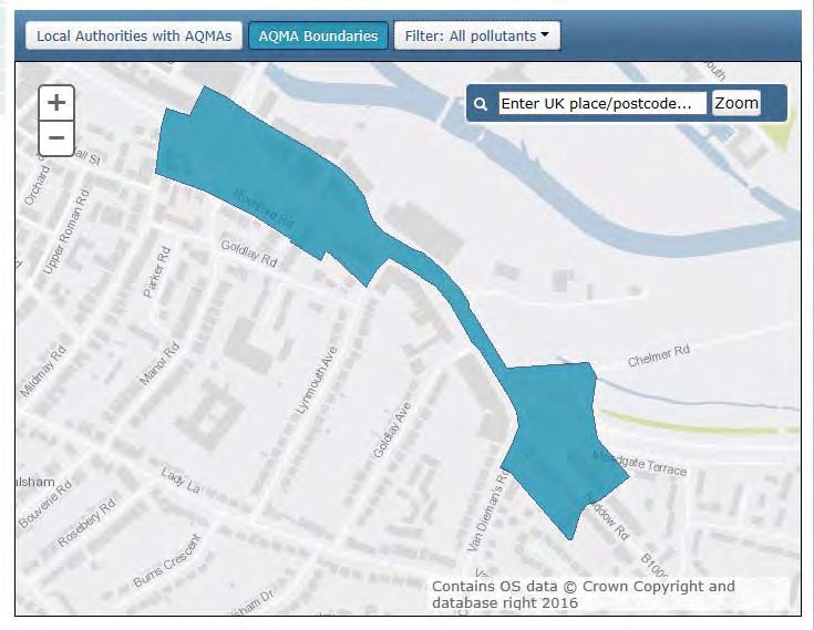
• Tackling Climate Change;
• Contributing to Better Safety, Security and Health;
• Promoting Greater Equality of Opportunity;
• Improving Quality of Life and Promoting a Healthy Natural Environment;
The top three options based on the DaSTS criteria were 1) Two-way flyover, 2) Two-way Bus Gate
on Baddow Road and 3) One-way Bus Gate on Baddow Road.
Option 1 was the best option – against the DaSTS criteria – scoring highly in terms of improving the
performance of the network as a whole, however the increased traffic flow attracted to the junction
itself results in a poor performance in terms of ‘Contributing to Better Safety, Security and Health’
with higher flows and queueing levels on Baddow Road. This option does not offer any additional
provision for public transport or provide any benefit to pedestrians and thus sustainable transport.
A separate set of objectives set at the time by the County Council were aligned towards measuring
the impact of the scheme in terms of its effect on the environment and providing sustainable travel.
The objectives were:
Journey Time Reduction for General Traffic
• Using the established road hierarchy to set priority of traffic movements
Journey Time Reliability for Public Transport
• Through promotion of public transport priority measures
Improved Accessibility for Cyclists
• To encourage modal shift (not necessarily through the junction)
Improved Accessibility for Pedestrians
• To encourage modal shift (not necessarily through the junction)
Improved Air Quality
• In line with the Army & Navy Air Quality Action Plan
ECC also set the key constraint on options developed that all objectives should be met without a
detrimental impact, in traffic terms (queuing and delay), on Parkway. The overall rankings against
ECC criteria are shown in the table below: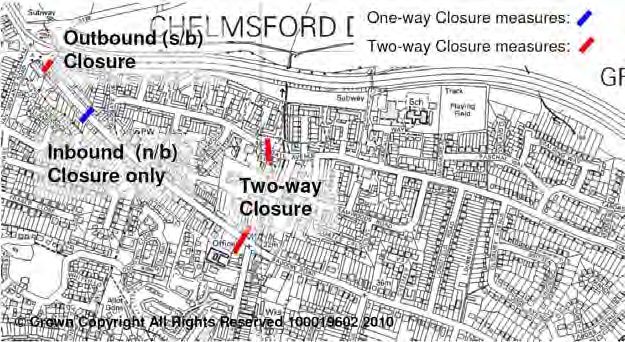
The ranking based on outputs from strategic and operational modelling ranked the Baddow Road
bus gate proposal number 1 of seven options assessed. This is largely due to scoring highly against
reliablility for public transport, improved access for cyclists and pedestrians, improved air quality and
no detrimental impact on Parkway. However, the previous DaSTS assessment ranked Option 1 as
highest scoring this has dropped to 4th against the ECC criteria, most significantly due to low scores
against reliablility for public transport, improved access for cyclists and pedestrians.

The top three options based on the ECC criteria were 1) Two-way Bus Gate on Baddow Road 2)
One-way Bus Gate on Baddow Road and 3) Gyratory.

It was noted in the report that there may well be scope to test other combinations (for example Option
5 with a two-way flyover). The modelling undertaken provided a broad indication of the area-wide
impacts of the options and the impact at the Army & Navy itself, however the study identified that
further work would need to be undertaken to better understand potential capacity issues at other
junctions in the area of the Army & Navy.

Baddow Road Closure Study – Modelling Report – Mouchel August 2010

A further study, specifically on the potential closure of Baddow Road to general traffic, was
completed in 2010 by Mouchel. The Baddow Road Closure Study – Modelling Report was
undertaken using the Chelmsford SATURN model with peak spreading and DIADEM and a local
area spreadsheet model. This modelling illustrated the potential impact of strategic redistribution of
traffic resulting from the road closure and modelled local junctions but did not assess in detail the
potential benefits in terms of modal shift to bus, walking and cycling.

The project objective was to further investigate the local traffic impact associated with the potential
closure of Baddow Road to general traffic. Two scenarios were investigated:

   1. One-way, town centre-bound (known as Option 5 in the Army & Navy study), closure to
      general traffic with bus gate between Army & Navy and Meadgate Avenue junctions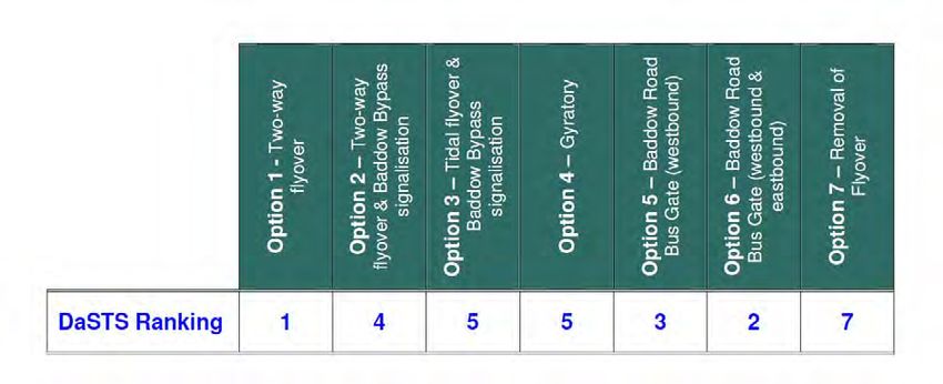
2. Two-way closure to general traffic (known as Option 6 in the Army & Navy study) with bus
gates on Baddow Road at Beehive Lane junction and on Meadgate Ave at the Army & Navy.
Figure 1 Modelled bus gate locations 2010
The study concluded from the analysis of the one-way and two-way Baddow Road west closure
scenarios, that:
The two-way closure scenario would have a more extensive impact on the operation of the
Baddow Road / Maldon Road corridor than the one-way closure scenario due to:
o Two-way reassigned traffic
o Additional two-way traffic and delay on High Street/Maldon Road corridor with limited
opportunities for mitigation at this location
The Maldon Road approach to the priority junction with the Baddow Bypass on-slip would
see a considerable worsening in operation in the AM peak with the reassignment from either
the one-way or two-way closure in place. This junction was considered, at the time, to be
likely to be difficult to mitigate due to its constrained location. It should be noted that the
Sandon Park and Ride has been expanded since this time and travel behaviour and further
modal shift is likely to have occurred on this corridor.
There were, however, significant benefits which could be accrued with both scheme options.
A major benefit on Baddow Road would be the removal of queuing from the Baddow Road
approach to the Army & Navy during peak periods, assisting in addressing the Air Quality
Management Area (AQMA) issue on the route. The removal of traffic entering the junction
would also be likely to assist the Army & Navy junction itself to operate more efficiently.
Within this study, the transfer to bus was conservatively estimated as a percentage of existing
trips and when these trips were removed from the network, it had a negligible positive impact
on the operation of the junction approaches. It was highlighted that in order to quantify the
overall mode shift to bus as a result of the bus corridor, significantly more detailed demand
modelling would need to be undertaken.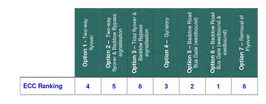
The creation of a bus corridor, with bus priority for the length of Baddow Road between
Beehive Lane and the Army & Navy, has the potential to attract people from a wider
geographical area onto the public transport system due to increased reliability and reduced
journey times. As such this may also help to reduce the impact of traffic reassignment.
The recommendations from the study were:
Given the limited scope for mitigating the Maldon Road / High Street / Baddow Road junction,
it was suggested that it may be more appropriate to pursue the one-way closure option rather
than the two-way closure option.
Further work would therefore be required to understand whether mitigation measures are
possible and appropriate at the Maldon Road / Baddow Bypass junction.
It may also be beneficial to undertake further modelling of the benefits that might be accrued
through mode shift to public transport on creation of a Baddow Road public transport corridor.
2 VISSIM model review/update of Mouchel 2010 reports (2016)
2.1 Review of Problems and Issues (2016)
In spite of recent improvements such as the widening of the exit onto Parkway, the left turn slip onto
Chelmer Road and the new Chelmer Viaduct, the Army and Navy Roundabout remains over capacity
in traffic terms, with heavy flows on all arms in the AM and PM peak. In fact (as predicted in
modelling), as capacity is created more traffic is attracted to the junction, potentially worsening
existing issues with air quality and queuing and impacts further along Parkway.
A summary of the 2016 issues identified are:
Trafficmaster journey time data shows that in peak hours, vehicles on Baddow Road sit in
queues travelling at speeds of between 0 and 5mph westbound from the junction with
Beehive lane until entry onto the Army and Navy roundabout
To travel the distance of Baddow Road from Beehive Lane to the Army and Navy Roundabout
(approximately 650 metres), it can take an average of an additional 6.5 minutes over the free-
flow journey time during peak periods – one of the most significant average delays on any
route feeding into Parkway.
A comparison of 5-day average link flows (Monday to Friday month of October), from 2011
through to the most recent counts from 2016 on Baddow Road (between Meadgate Avenue
and the Army and Navy junction) has been carried out to provide an indication of recent peak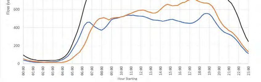
hour – 8am-9am & 5pm-6pm – traffic flows on the corridor. A six year average for westbound
flows shows AM peak hour is 338 vehicles and PM peak hour 451 vehicles. Overall, while
flows change from year to year there is no evidence of significant peak hour traffic growth on
this corridor over the last 6 years. This lack of growth indicates that the route is at capacity
in these time periods.
Baddow Road accounts for just 7% of the total traffic flow entering the Army and Navy
Roundabout in the AM peak and 8% in the PM peak. However this traffic directly affects the
significantly larger flow of traffic entering from Van Diemans Road.
There is no bus priority in this corridor despite this being a key route for buses.
Air quality is poor with the area formally registered as an Air Quality Management Area
(AQMA) identified as covering the Army & Navy junction and the western section of Baddow
Road.
Background data for the figures detailed above are contained in Appendix 2.
2.2 Review of Modelling (2016)
The Chelmsford City Growth Package option for an improvement scheme at the Army and Navy /
Baddow Road was selected based on the findings from two Mouchel studies completed in 2010.
The identified options were reviewed using current data and modelled in the Chelmsford VISSIM
model (2014). The full studies can be found in the following reports:
TN01 Army and Navy Options Tested Technical Note 25th April 2016
TN03 Army and Navy – Baddow Road Closure Technical Note 6th September 2016
A brief summary of these reports and the findings are detailed below.
TN01 Army and Navy Options Tested Technical Note
A number of potential options for improvement of the Army and Navy were assessed at the request
of ECC using the 2014 Chelmsford central area VISSIM model.
The specific options tested and modelled outcomes are:
1. Full/partial signalisation of the roundabout (with signal timings from LinSig model).
The VISSIM model showed that the close proximity of stop lanes on the roundabout and the
lack of stacking capacity for circulating stop lines caused the roundabout to very rapidly lockup, inhibiting traffic from entering the roundabout and significantly increasing the queues on
the approaches to the junction.
2. Baddow Road - Bus Gate north-westbound and no change to general traffic exiting from the
roundabout south-eastbound, without signals.
This option indicated the best potential for improvement but limitations in available data on
rerouting of traffic meant that it was impossible to reach a conclusion as to its suitability within
this report – to be tested again with VISUM strategic modelling results
3. Baddow Road - Bus Gate north-westbound and no change to general traffic exiting from the
roundabout south-eastbound, with partial signalisation of the roundabout.
The VISSIM model showed that the close proximity of stop lanes on the roundabout and the
lack of stacking capacity for circulating stop lines caused the roundabout to very rapidly lock
up in the section between Chelmer Road and the circulatory stop line for Essex Yeomanry
Way, inhibiting traffic from entering the roundabout and significantly increasing the queues
on that approach to the junction and on Chelmer Road.
4. Two way flyover to replace / supplement existing structure.
In order to construct a two-way structure without significant land purchase it was necessary
to lose a lane on the Parkway approach to the roundabout. The AM peak period shows some
improvement to Chelmer Road since circulating traffic past this entry drops. It shows an
increase in delay on all other arms because the traffic originally queued on Chelmer Road is
released to add to circulatory flows.
The PM peak shows a significant worsening of the queuing and delay on Parkway because
of the reduced capacity of the roundabout entry, with a latent demand of 600-700 vehicles
on that approach (4km of queuing traffic). Without significant land take this option was not
considered viable with current traffic flows.
Note: Replacement flyover options are currently being evaluated further by ECC as a
separate longer term option study outside of the Chelmsford City Growth Package.
TN03 Army and Navy – Baddow Road Closure Technical Note
A number of potential options for improvement of the Army and Navy have been identified in the
previous studies detailed above. Option 2 – ‘Making Baddow Road exit only from the roundabout
for general traffic’ offered the best potential for improvement.
A strategic 2014 Chelmsford VISUM model covering the entire city has since been constructed by
Essex Highways on behalf of ECC. This model allowed for an updated prediction in relation to likely
redistribution of traffic over the wider area and the scenario was modelled using the version available
at the time (pre-Local Plan testing).The results of the strategic modelling, with and without Baddow Road open, indicate that traffic
currently using Baddow Road is likely to redistribute over the wider network, heading back through
Great Baddow, via Wood Street or via the A12. These findings are broadly in line with the original
2010 study.
Of specific concern to the Army and Navy roundabout are the redistributions to Essex Yeomanry
Way (Baddow Bypass) and Van Diemans Road. This modelled redistribution is shown below.
Table 1: Absolute increase in traffic on Army & Navy approaches from the 2014 Chelmsford VISUM
Model
To Essex Yeomanry Way
To Van Diemans Road
(Baddow Bypass)
From Baddow 102 pcus* 48 pcus*
Road AM peak
period (0800-0900) (26.2% Baddow Rd flow) (12.3% Baddow Rd flow)
From Baddow 121 pcus* 45 pcus*
Road PM peak
period (1700-1800) (25.0% Baddow Rd flow) (9.4% Baddow Rd flow)
*pcus – passenger car units
The remainder of traffic reassigned over a wider area, for example accessing the A12 or travelling
via Wood Street and New London Road. Due to the nature of strategic traffic reassignment, as traffic
moves from one route to another, it in turn displaces traffic on this route so absolute increases may
not necessarily be seen on all other routes.
The traffic flows used within the VISSIM model were manually adjusted to take account of traffic
redistribution indicated by the VISUM model and the VISSIM models re-run to assess the impact of
the closure of Baddow Road westbound to all vehicles except buses and cycles.
The results are summarised as follows:
Removal of one of the five arms of the roundabout is shown to improve the overall traffic
operation of the Army & Navy junction but without the overall disbenefit of causing significant
traffic growth at the junction and along Parkway.
o Although queuing is expected to increase on Baddow Bypass, VISSIM modelling
shows that the adjusted balance of flows at the Army and Navy is likely to result in no
overall increase in delay on this arm.o Modelling in VISSIM identifies a significant benefit in terms of reduced delay for traffic
approaching via Van Diemans Road in the evening peak (around 2.5 minutes on
average per vehicle). The morning peak is broadly similar to existing conditions.
Removal of queuing traffic on Baddow Road likely to provide a beneficial impact on the
existing AQMA.
Significant potential for modal shift to bus and cycle due to removal of inbound queuing and
improved bus journey times along Baddow Road.
The 2010 study identified the Maldon Road / Baddow Bypass junction as being particularly under
pressure with the closure of Baddow Road westbound and possibly requiring mitigation. The junction
has been remodelled with 2016 traffic data in ARCADY software in order to assess possible
mitigation. This assesses the current situation and the assumed ‘worst case’, where all traffic from
Baddow Road enters the roundabout from Maldon Road west.
A modelled RFC of 1.0 indicates that the junction is at capacity and that significant queuing may
become apparent. All of the reassigned traffic from Baddow Road being assigned to the Maldon
Road west arm results in an RFC of 0.72, indicating that the junction is still likely to be working within
capacity (this assumes that the exit from the junction remains clear).
It should also be noted that the average traffic flows for Baddow Road identified in this report are
338 vehicles in the AM peak and 451 for the PM peak based on a 6-year 5-day average of October
flows. Therefore, the figures used in the ARCADY are considered robust in assuming 430 vehicles
reassigning to the junction in the AM peak and 540 vehicles in the PM peak.
2.3 Meadgate Bus Gate Option
It was initially proposed to Essex Highways that an alternative option of a bus gate via Meadgate
Avenue connecting to Essex Yeomanry Way / Baddow Bypass Bus Lane should be reviewed. On
site investigations to look at this option were undertaken alongside the VISSIM modelling to establish
whether this could be viable.
The findings from this initial review were as follows:
Disparity of levels, over a very short distance, between Meadgate Avenue and Essex
Yeomanry Way would present a number of engineering challenges.
‘Punching through’ from the existing residential cul-de-sac would require the removal of the
current safety barrier, street furniture and the removal of the current vegitated fence which
provides a visual and sound barrier for residents of the local area. This could potentially
extend as far as the current turning head outside property no. 1 Meadgate Terrace.
Junction design could require removal of or alterations to private retaining walls for adjacent
properties.
Removal of the fencing would no longer prevent pedestrian access to Essex Yeomanry Way. A signalised junction would be required to allow buses to safely access Essex Yeomanry
Way (due to poor visibility). This would need to be designed to accommodate the swept path
of the buses turning out of the junction. The location of this junction would be adjacent to the
base of the flyover.
The residents of Meadgate Terrace would only be able to enter / exit via a signalised junction.
Residents parking in Meadgate Avenue would need to be removed and relocated.
The current width of Meadgate Avenue on the approach to Meadgate Terrace may only
accommodate single directional flow when being used by buses.
The alignment of the Baddow Road / Meadgate Avenue junction would need to reviewed to
accommodate increased bus usage.
Enforcement of junction would have to be considered.
Multiple Statutory Undertakers have apparatus within the area that would require diversion
works.
VISSIM modelling indicated ‘no benefits’ to buses over existing conditions. The key issue of the bus
having to sit in the same congestion down Baddow Rd will continue to exist. Buses right turning into
Meadgate Avenue from Baddow Road would not have priority over exiting eastbound traffic from the
Army and Navy and would have to wait to right turn. Alternatively, buses could be given priority into
Meadgate Avenue however this would interrupt the flow of traffic exiting the Army and Navy.
Through discussion of these issues and review against cost and benefit, it was concluded that this
option was not viable.
2.4 Potential mitigation
Optimisation of Army and Navy Part Time Signals
There are currently part time signals for the Parkway and Chelmer Road arms of the roundabout. It
is considered that the existing part-time signals on the Army & Navy roundabout could be used to
better optimise and control the balance of flow between Baddow Bypass and Chelmer Road with the
bus gate in place. The recent reconfiguration of Chelmer Road and potential future addition of traffic
to Baddow Bypass would warrant a review of signal timings and operation. This will be reviewed
through later detailed design of any preferred option.
The ‘TN01 Army and Navy Options Tested Technical Note’ modelling results indicated that ‘lack of
circulatory space’ will cause problems with signal usage on the Army and Navy roundabout if signals
are added at the Baddow Road arm.
Maldon Road Baddow Bypass
If mitigation were required at the Maldon Road / Baddow Bypass on-slip junction it is considered
likely (without having undertaken detailed modelling) that based on recent flow data at the junction,
signalisation would be possible to ensure that traffic from Maldon Road west can exit onto the
Bypass.2.5 Trial Period Given the complexity of potential re-routing / mode changing options for vehicles currently travelling down Baddow Road, it is suggested that trialling of the scheme for a period of 18 months under an experimental order would be most appropriate to assess the issues and opportunities on the ground and allow full optimisation of the scheme. 3 Public Consultation Essex County Council has developed a vision of a ‘Future Transport Network’ for the city with the intention to make all modes of transport attractive,encouraging more sustainable travel on foot, by bicycle and on public transport with an aim of reducing the number of cars on the road and improving air quality for all residents. In March 2017 Essex County Council spoke to all residents, workers, shoppers and partners about Chelmsford’s Future Transport Network and sought feedback on the corridors that were identified as in need of investment. From this feedback and issues raised on these corridors a number of schemes were developed. These schemes were developed into a package of measures and taken forward in the consultation documents for the public and stakeholders to view and respond to. The Chelmsford City Growth Package public consultation commenced on 17th July 2017 for a six week duration, closing on 28th August 2017. All detail of the consultation were hosted on the Essex County Council Website, which also allowed respondents to leave feedback regarding the proposals. www.essex.gov.uk/chelmsfordtransport Feedback on the proposals could be given by: Completing the online questionnaire on Essex County Councils website; Emailing feedback to ChelmsfordGrowthPackage@Jacobs.com or Completing the questionnaire in the consultation brochure and submitting it via post. The questionnaire contained a total of 11 questions, and these were a mixture of closed questions to allow for the capture of information, and open questions to gather respondents’ views. Demographic questions were also included to aid understanding of who had responded. The consultation was publicised using social media (including Essex County Council’s Facebook page and Twitter feed), press releases and email updates. Seven public events were held locally, to allow stakeholders to view the proposals, meet the project team, ask any questions, and raise any concerns. The Chelmsford City Growth Package proposed 28 potential schemes, which were documented over 5 volumes of information (Baddow Road Bus Gate was presented in two volumes), along with measures for city-wide signage and technology improvements.
The findings from the consultation are detailed in full in the ‘Chelmsford City Growth Package –
Consultation Report’ - dated 27th October 2017.
3.1 Description of preferred option presented at consultation
Army and Navy Roundabout Improvements: Baddow Road Bus Gate
Where is the scheme?
The Army and Navy roundabout is a key gateway to the city and is a key point on the network where
five roads meet at the junction. The Baddow Road approach to the junction is a primarily residential
access onto the junction and suffers severe congestion during peak periods.
The recommendation based on assessment to this point was to install a westbound ‘bus gate’
between Meadgate Avenue and the Arny & Navy roundabout on the Baddow Road arm of the Army
and Navy roundabout proposed to be in operation 24 hrs per day and 7 days per week.
The Western end of Baddow Road falls within the Air Quality Management Area (AQMA) around the
Army and Navy junction. An Air Quality Management Area is designated by a local authority when it
considers that national air quality objectives will not be met.
The Consultation Proposal
The proposal at the consultation was to:
Install a ‘bus gate’ on the Baddow Road arm of the Army and Navy roundabout. A westbound
bus gate between Meadgate Avenue and the roundabout was proposed to be in operation
24 hrs per day and 7 days per week.
Cameras would be in place to enforce the bus gate.
Access into Baddow Road from the roundabout would remain as it is.
To improve the operation of the Army and Navy roundabout by removing one of the
approaches for regular vehicle movements
To create a faster and more reliable sustainable transport corridor making bus journeys an
attractive alternative to car journeys.
The proposal at consultation was for operation 24 hrs per day and 7 days per week as this would
provide:
Greater benefits with regard to congestion reduction / air quality improvements
Simple operation of the bus gate with no confusion over operating hoursThe Initial assessment, detailed further in Section 5, suggests that the scheme is likely to improve
air quality on Baddow Road by reducing general traffic and associated queuing.
Figure 2: Consultation Illustration to show Baddow Road Proposal
The Baddow Road bus gate scheme will also be supported by complementary measures that have
been included in the overall package of proposals. These include:
Gt Baddow to City Centre cycleway (see Volume 5 of the consultation document); and
Parkway Corridor improvements (see Volume 4 of the consultation document).
The first part of the bus gate would be installed just to the north-west of the junction with Meadgate
Avenue adjacent to the grass verge area and would take the form of two “gateway signs” either side
of the carriageway displaying signs to TSRGD diagram number 953 (route for use by Buses, pedal
cycles, motorcycles and Taxis only) which would prevent any other vehicles from continuing towards
the Army and Navy Roundabout at all times. A second gateway with the same signage would be
installed just prior to the entry to the Army and Navy Roundabout to prevent any unauthorised
vehicles exiting onto the roundabout at all times. This is to discourage drivers from attempting to
bypass the first bus gate by travelling along Meadgate Terrace and cutting through the car park and
access of the Sutherland Lodge Doctors Surgery.
Both Gateways would be enforced by CCTV cameras.
Advance signage along Baddow Road, Maldon Road and Beehive Lane would be erected to
discourage drivers from travelling along Baddow Road to access the Army and Navy prior to reaching
the Meadgate Avenue junction.
Residents located within Baddow Road between the Army and Navy Roundabout and Meadgate
Avenue would only be able to access their properties via the Army and Navy Roundabout and leave
their properties via Baddow Road south-eastbound.
The details are shown on General Arrangement Drawing B355338A-01-001 rev- included within
Appendix 5.The bus gate will be implemented for an 18-month trial to monitor the impacts on both local traffic
and the traffic using the Army and Navy roundabout. Further options to optimise operation at the
Army and Navy will be assessed during this period once traffic has settled into the new travel
patterns.
It is anticipated that the scheme would be implemented within the duration of Growth Package
Implementation of 2018-21, with monitoring being carried out through financial years 2019/2020 and
2020/2021 and any additional mitigation measures being installed as identified from monitoring of
the scheme.
4 Consultation Outputs
Summary of Consultation Findings
A total of 921 responses were received. Most (85%) were from individuals responding on their own
or, in one instance, on behalf of a friend or relative. Responses were received from 29 Councils,
businesses and other organisations, making up 3% of responses. Some respondents (12%) did not
indicate in their response, but were assumed to be individuals.
Open Questions
Respondents to the consultation could leave comments on any of the proposed schemes.
The schemes that received the most comments were:
Army & Navy Roundabout Improvements: Baddow Road Bus Gate (Volumes 4 and 5 – 697
responses from the two volumes)
Broomfield Road Corridor (Volume 1 – 102 responses)
Odeon Bridge /High Bridge Road (Volume 4 – 91 responses)
Many comments were received saying that the introduction of a bus gate at this location would
displace traffic and the respondents disagreed with the scheme overall. Some responses
commented that the flyover should be improved to allow two-way operation.
Closed Questions
Over two thirds of responses came from respondents who travel most regularly by car, mainly as
drivers, with a small number as passengers. Just under a quarter of responses came from those
who identify their most regular mode of travel as walking, cycling or bus.
The percentage of those who responded with ‘strongly agreed’ or ‘agreed’ with the consultation
statements are detailed below: 91% that ‘Something needs to be done to improve traffic and congestion in Chelmsford’
70% that ‘more transport options were needed in Chelmsford’
80% that ‘they regularly experience congestion when travelling in or around Chelmsford’
63% ‘We need to do more to encourage people to cycle, walk or use public transport rather
than use private vehicles’
59% that ‘more focus was needed to improve cycling provisions’
55% that ‘more focus was needed to improve walking options’
40% that ‘public transport needs greater priority over private vehicles’
77% that ‘Where they obstruct traffic flows (and particularly in peak periods), vehicles should
be encouraged to park elsewhere’
46% that ‘better enforcement of bus lanes was needed’
Amongst those who gave a response, the three areas where there was most interest in seeing
improvements made as part of the Chelmsford City Growth Package were:
1. The City Centre;
2. Parkway Corridor; and
3. Southern and Eastern areas of the city.
Of the schemes consulted on, the top three by prioritisation were:
• Broomfield Road Corridor – 66 responses as Priority 1
• Army & Navy Roundabout Improvements (Parkway Corridor) – 60 responses as Priority 1
• Chelmsford City Centre Cycling Connectivity – 59 responses as Priority 1
Army & Navy Roundabout Improvements: Baddow Road Bus Gate (Volume 4 and Volume 5
responses)
Comments on this scheme (combined): 697
This scheme received a large number of responses, including the submission of a petition signed by
1,628 people (opposing the Baddow Road Bus Gate scheme, but supporting a two lane flyover), and
one campaign, with 15 submissions (#NoToBaddowBusGate). Chelmsford City Council, Great
Baddow Parish Council and the Mid Essex Business Group objected to the proposal for the busgate. Sutherland Lodge Surgery Patients Representation Group submitted a response on behalf of the surgery that is located in Baddow Road. Many respondents disagreed with the proposal whilst a few respondents agreed or agreed with caveats. Many respondents disagreed with the benefits the scheme may achieve, with many stating that congestion will be displaced to other areas and roads. A number of responses to other questions stated that congestion would be displaced by this proposal. A large proportion of responses to other questions also disagreed with the scheme, with a large number also disagreeing with the benefits of the scheme. Several respondents disagreed with the proposed installation of a 'bus gate' between Meadgate Avenue and the Army & Navy roundabout. A large proportion of responses to other questions also disagreed with this element of the scheme, with a number of respondents making suggestions regarding this. Some disagreed with the proposed hours of operation of the bus gate, with a few comments being made regarding this. A number of respondents to other schemes also stated that they disagreed with the proposed hours of operation of the bus gate. One respondent agreed with the proposed installation of the bus gate, and two respondents agreed with caveats. Several respondents mentioned possible other impacts from the scheme or making suggestions about the scheme. Several also submitted alternative proposals. Some respondents replied that a flyover was preferable to the proposed scheme. A few commented on the discounted option that the flyover should be replaced with a two-way structure or made comments about the existing flyover. Some respondents to other schemes also made comments with regards to the flyover being a discounted option. A large number of respondents to other schemes stated that a flyover was their preferred option for the scheme, with a large number making general comments about the flyover. A few respondents made comments about the discounted option of full signalisation of roundabout. Individual responses to the Baddow Road Bus Gate can be found summarised in Appendix 3. Stakeholder responses can be found summarised in Appendix 4. 5 Revised Preferred Option 5.1 Reasoning Feedback from the consultation and further engagement with ECC Network Assurance and Network Operations Teams has led to a revised proposal that should deliver the majority of the benefits whilst addressing some of the key concerns raised at consultation. The revised proposal comprises of a gateway only being installed just to the north-west of the junction with Meadgate Avenue adjacent to the grass verge area. Operation of the bus gate will be
part-time for AM (07:00–10:00) and PM (16:00–19:00) weekday peak hours only. Outside of these
times all traffic will be able to travel north-west along Baddow Road and access the Army and Navy
Roundabout. The part-time operational hours mirror those of the nearby New London Road bus lane
and county-wide policy and interact with the operation of the tidal Army and Navy flyover.
A small central island will be installed in Baddow Road to locate the gateway signage and a CCTV
used for enforcement during the operational hours. Advance signage with operational times
displayed would be erected along Baddow Road, Maldon Road and Beehive Lane (as a minimum)
to discourage drivers from travelling along Baddow Road to access the Army and Navy prior to
reaching the Meadgate Avenue junction. The details are shown on Scheme Overview Drawing
B355338A-00-001 rev- included within Appendix 5.
Implications:
Reduced operational hours are likely to slightly diminish the benefits of the proposal
(congestion reduction / air quality improvements), however the benefit reduction is
anticipated to be relatively minor.
Residents with the longest diversions to access the Army and Navy Roundabout – i.e. those
between the Army and Navy and Meadgate Avenue – will still be able to access the
roundabout at any time.
Reduced likelihood of vehicles using the on-street parking attempting to make U-turns.
No bus priority measures are in operation during the weekends so weekend shopping would
be unaffected.
No bus priority measures are in operation during the weekends so congestion and bus delay
may still occur during weekend peak times.
Visitors to the Doctors surgery can exit towards the roundabout at all times.
Responds to public comments and criticism of perception that scheme was diverting traffic
unnecessarily during quieter off-peak periods.
Risk that, although the part-time operation should limit the dis-benefits, it may add to the
complexity of the solution in terms of signage (additional sub-plates are required) and to the
confusion around its operational hours.
5.2 Air Quality Modelling
In accordance with HA207/07 of the Design Manual for Roads and Bridges (DMRB), detailed air
quality modelling was undertaken to assess the impact of the Baddow Road Bus Gate both in
isolation and combined with the other CCGP improvements along the Parkway corridor. This
modelling was undertaken to ascertain whether the implementation of these proposals had a
significant impact – positively or negatively – to the local air quality, particularly within the designated
AQMA. Below are detailed the conclusions associated specifically related to Baddow Road Bus Gate
as a standalone project; Design Scenario 3 (DS3).Existing nitrogen dioxide (NO2) concentrations along Baddow Road (from the circulatory of the roundabout to Meadgate Avenue) are modelled at between 68% and 103% of the national Air Quality Objectives (AQO) (with a mean of 84%). The report concludes that, due to the proposed changes at this location, small improvements in NO2 concentrations (of up to 5%) would be realised at the 10 modelled sites on Baddow Road. Equally, there were also small improvements at the 3 sites on Van Diemans Road due to the reduced congestion on the approach to the junction. Conversely, small deteriorations are expected at 2 of the modelled sites along Baddow Bypass. However, it is recognised that existing air quality at these sites is at a lower background concentration (
The anticipated benefits of this proposal include:

•      Improved air quality along Baddow Road through substantial reduction in queuing traffic by
       prohibiting the majority of north-westbound general traffic;

•      Creation of an attractive bus corridor along Baddow Road; and

•      Improved operation of the Army & Navy roundabout by effectively removing one arm.

The revised proposal addresses some of the concerns raised through the public consultation.
Potential mitigation measures can be identified ahead of implementation and during the 18-month
trial. It is therefore recommended that the preferred option is amended to account for the above
changes and is taken forward to the next phase of design and implementation.

Note: Options for a replacement flyover should continue to be looked at by ECC as a separate longer
term option study to assess the cost and benefits of such a solution.
Appendices Appendix 1 – 5 DaSTS goals ............................................................................................................................. 25 Appendix 2 – Data for 2016 update ................................................................................................................ 26 Appendix 3 – Invidual Consultation Comments – Baddow Road .................................................................... 35 Appendix 4 – Stakeholder and Group Consultation Comments – Baddow Road ........................................... 40 Appendix 5 – Scheme drawings ....................................................................................................................... 44
Appendix 1 – 5 DaSTS goals Each of the improvement options were evaluated against this scenario using model outputs aligned to the 5 DaSTS goals; • Supporting National Economic Competitiveness and Growth; Effect of Peak Spreading & DIADEM Total Distance Travelled Distance per Vehicle Loaded Total Travel Time Travel Time per PCU Difference in Travel Time compared to Do-Minimum % Change in traffic on A12 • Tackling Climate Change; CO2 (kg) across the network Difference in CO2 (%) compared to Do-Minimum • Contributing to Better Safety, Security and Health; Queuing weighted by approach to the Army & Navy Traffic Flow on each approach to the Army & Navy Difference in Traffic Flow compared to Do-Minimum • Promoting Greater Equality of Opportunity; Qualitative Impact on Bus and Rail • Improving Quality of Life and Promoting a Healthy Natural Environment; Qualitative Impact on Pedestrians & Cyclists Sum of queuing on all approaches
Appendix 2 – Data for 2016 update
The Army and Navy Roundabout is widely recognised as a key pinch-point on the Chelmsford
transport network, with heavy traffic flows on all arms in the AM and PM peak periods in particular.
As a result, queuing is prevalent and air quality is poor with the area formally registered as an Air
Quality Management Area (AQMA) identified covering the junction and the western section of
Baddow Road.

                                                    Army & Navy

               Figure 1: Chelmsford AQMA (Source DEFRA AQMA Interactive Map)

Speed Analysis

The table below shows analysis of free flow versus peak hour speeds along the corridor from the
2014/15 Traffic Master data. This shows significant speed reductions of between 85 and 87% on
the westbound AM flows due to congestion on the section between Parkway and the Beehive Lane
junction. As there is no current provision of bus lanes at this location, bus service journey times and
reliability are also affected by the reduction in speed and observed queuing.
Table 1: Observed Average Speed v's Free Flow Speed AM/PM Peak Baddow Road
Route (between
Free Flow Speed % of Free
Beehive Lane Length Speed
Speed reduction Flow
Roundabout and the (m) (mph)
(mph) (mph) Speed
Army and Navy)
Baddow Road North-
westbound 666 26 3 23 13%
(8:00-9:00)
Baddow Road North-
666 26 4 22 15%
westbound (17:00-18:00)
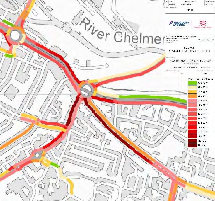
This information is presented visually in the following congestion plots based on 2014/15 Traffic
Master data again showing congestion pressures on Baddow Road in the AM north-westbound.
Figure 2: 2014‐15 Army & Navy Roundabout AM Peak Traffic Master Congestion PlotFigure 3: 2014‐15 Army & Navy Roundabout PM Peak Traffic Master Congestion Plot Journey Times Journey times along the Baddow Road link between the Beehive Lane Roundabout and the Army and Navy Roundabout are shown below and the most significant delay in minutes and seconds is highlighted to be on the AM peak north-westbound section followed by the PM peak north-westbound section. It should be noted that this is an average delay and that sometimes the actual delay is above or below this level.
Table 2: Journey Time Delay Baddow Road AM/PM Peak (2014/15 Traffic Master data)

       Route (between                             Free Flow     Average
                                     Free Flow
        Beehive Lane       Length                  Journey      Journey        Delay
                                      Journey
     Roundabout and the      (m)                     Time         Time       (min:sec)
                                     Time (sec)
       Army and Navy)                             (min:sec)    (min:sec)

     Baddow Road North‐
         westbound           666         57         00:56       07:30          06:33
         (8:00‐9:00)
     Baddow Road North‐
         westbound           666         57         00:56       06:13          05:16
        (17:00‐18:00)

Traffic Flow Data

Traffic flows on Baddow Road have been analysed for the period January 2016 to December 2016
and the average vehicle flows are shown below:

            Figure 4: Average weekday traffic flow on Baddow Road (Jan16‐Dec16)
A link flow comparison on Baddow Road between Meadgate Avenue and the Army and Navy junction
has been carried out to provide an indication of recent peak hour traffic flows on the corridor. The
data used for comparison are the 5-day average (Monday to Friday) link counts for the month of
October from 2011 through to the most recent counts from 2016.
Table 3: Traffic flows between 2011 and 2016 on Baddow Road between Meadgate Avenue and
Army and Navy junction
Average weekday Traffic count for October (vehs)
BADDOW ROAD, NW
OF MEADGATE AVE) 2011 2012 2013 2014 2015 2016 Ave.
Baddow Road North-
westbound 320 349 330 263 402 362 338
(8:00-9:00)
Baddow Road South-
eastbound 484 540 443 416 472 480 473
(8:00-9:00)
Baddow Road north-
westbound (17:00- 406 492 472 412 482 441 451
18:00)
Baddow Road south-
westbound (17:00- 753 780 758 659 696 722 728
18:00)
This comparison indicates that flows in 2016 in both peak hours on this link are represented by the
6-year average of the peak hour flows on this link. In general, the highest flows for the month of
October were in 2012 and the lowest in 2014. Overall, while flows change from year to year there
is no evidence of significant peak hour traffic growth on this corridor over the last 6 years. This lack
of growth indicates that the route may be at capacity in these time periods.
Traffic Flow Distribution per arm on the Army and Navy Roundabout
Traffic flows for the Army and Navy Roundabout from June 2016 have been tabulated (Table 4) with
the largest individual movements highlighted in red. It should be noted that the flow on Baddow Road
for the AM and PM peak roundabout entry is higher than both 2016 yearly average and the 6-year
average. This means that this analysis is recording a percentage for the AM/PM peak which is
higher than the yearly figure so is robust.Table 4: Army and Navy Roundabout 2016 Traffic Flows AM peak and Percentage Entry and Exit
for radial arms
Entering
Exiting to
from
Army and Navy Roundabout June Entering Traffic Exiting to
Traffic
2016 Junction Count from % Count %
Count
(Vehs)
(Vehs)
1238+
A1060 Parkway 1,098 18% 1547 44.5%
flyover
A138 Chelmer Road 1,447 23% 1168 19%
1,076 +
A1114 Baddow Bypass 1,547 42% 951 15%
flyover
B1009 Baddow Road 453 7% 433 7%
A1114 Van Diemans Road 625 10% 909 14.5%
Figure 5: June 2016 Parkway AM Peak Traffic Flows Army and Navy RoundaboutIn this assessment Baddow Road accounts for 7% of the total traffic flow entering the Army and
Navy Roundabout. The predominant flow in the AM peak is from the Baddow Bypass accounting
for 42% of the total flow entering the Army and Navy Roundabout. Of this the movements through
to Parkway both via the flyover and the main circulatory carriageway from Baddow Bypass account
for 32% of the total traffic flow movements.
Table 5: Army and Navy Roundabout 2016 Traffic Flows PM peak and Percentage Entry and Exit
for radial arms
Entering
Exiting to
from
Army and Navy Roundabout June Entering Traffic Exiting to
Traffic
2016 Junction Count from % Count %
Count
(Vehs)
(Vehs)
1,322 +
A1060 Parkway 1,343 42% 1317 21%
flyover
A138 Chelmer Road 1,367 22% 1652 26%
667 + 1343
A1114 Baddow Bypass 1,089 17% 32%
flyover
B1009 Baddow Road 501 8% 650 10%
A1114 Van Diemans Road 723 11% 716 11%Figure 6: June 2016 Parkway PM Peak Traffic Flows Army and Navy Roundabout Traffic flows for the Army and Navy Roundabout in the PM peak hour, show that the predominant flow in the PM peak is from Parkway accounting for 42% of the total flow entering the Army and Navy Roundabout. 32% of exits from the roundabout are onto Baddow Bypass and 26% onto Chelmer Road. The movement through to Baddow Bypass both via the flyover and the main circulatory carriageway from Parkway accounts for 25% of the total traffic flow movements. Baddow Road accounts for 8% of the total traffic flow entering the Army and Navy Roundabout. Baddow Road Redistribution In 2014 ECC commissioned a new strategic model of Chelmsford which has been built in VISUM and a micro-simulation model of the Chelmsford City Centre area built in VISSIM. A test was run using the newer VISUM model to analyse the likely patterns of traffic redistribution in the AM and PM peak hours resulting from the Baddow Road bus gate. Similarly to the older SATURN model, VISUM showed traffic transferring to Baddow Bypass and Van Diemans Road with the remainder of traffic dissipating over a wider area for example accessing the A12 via Junction 18 or travelling via Wood Street and New London Road.
As a result of this updated modelling, a slightly higher level of increase was seen directly onto the
Baddow Bypass and therefore these figures were used to inform the reassignment of traffic in the
VISSIM model.

Table 6: 2014 VISSIM model outputs showing predicted average delay (seconds per vehicle) at
the Army & Navy roundabout with and without Baddow Road bus gate

When additional traffic is added to Essex Yeomanry Way (Baddow Bypass) with Baddow Road
closed to general traffic north-west bound, VISSIM modelling suggests that the queue increases but
with no significant impact upon average delay because of the altered traffic flow patterns at the
roundabout allowing vehicles to access the roundabout more quickly.

As expected, Baddow Road, with only buses and cycles in a north-westbound direction, has no
significant queuing or delays inbound, providing a fast and reliable route for buses which is also likely
to benefit the air quality on this corridor (which is currently registered as an AQMA).

Modelling also suggests that while the Baddow Road bus gate does not have a significant impact on
the throughput of Van Diemans Road in the AM peak period, the changes in flow patterns on the
roundabout are likely to lead to a significant reduction in delays during the PM peak period. The most
recent modelling suggests that Parkway and Chelmer Road are not likely to be significantly affected
by the closure of Baddow Road.
Appendix 3 – Individual Consultation Comments – Baddow Road
Comments regarding the scheme included:
‘Baddow Road is currently very busy only during the AM peak, and therefore the proposal
should not be introduced for a 24 hours per day’
‘The bus lane would make access to the Doctors’ surgery in Baddow Road difficult for local
people’
‘The proposals will not meet the objectives if the current price of bus fares is not reviewed. It
is felt that the main impediment to bus use is the high cost rather than lack of journey time
reliability.’
Of those that agreed to the scheme with caveats, comments included:
‘I broadly agree with on Baddow road, but the problem will just shift to Loftin Way instead,
ten into Miami roundabout and new London road as people are forced to find new routes.’
‘Good idea in principle. There is little mention of issues arising from re-assignment of traffic.’
‘Great idea. But only for buses in mornings and afternoon rush hour. And ensure bus fares
are affordable then people will use them.’
Understand the easing of traffic at the Army and Navy but it could put a huge amount more
pressure on the Great Baddow area especially near the Vineyards area (where more housing
is being built too) and on New London Road.’
‘Any improvement to improve timekeeping and reliability of public transport is to be
welcomed. However, I don't see real improvement to traffic flow until the flyover is made two-
lane.’
Comments received disagreeing with the scheme included:
‘Buses should not be given priority on Baddow Road. Cars will be forced to go alternate
routes through residential areas, past schools (Moulsham/Beehive Lane) and past children
walking to school which increases risk to them. Traffic on Baddow Road is not an issue off
peak.’
‘You are making local residents drive further and as a result moving the congestion
elsewhere. I also believe this will create more pollution in the process as traffic will back on
the bypass instead.’
‘This roundabout can be horrendous but I really do not see the logic of just making it possible
for buses to turn into Baddow Road, I use this road regularly for Billericay and taking a bus
is not practical. This will cause more traffic on other roads. Something needs to be done here
but making it bus only I don't see is the answer.’You can also read