CNES-ISRO COLLABORATIONS IN EARTH OBSERVATION
←
→
Page content transcription
If your browser does not render page correctly, please read the page content below
CNES-ISRO COLLABORATIONS IN EARTH OBSERVATION :
MEGHA-TROPIQUES, SARAL, TRISHNA AND THE SPACE CLIMATE OBSERVATORY (SCO)

                                               PIERRE TABARY
            PROGRAMME MANAGER FOR ATMOSPHERE, METEOROLOGY AND CLIMATE
                  CNES, DIRECTORATE FOR INNOVATION, APPLICATIONS, SCIENCE
                                              20TH OF NOVEMBER, 2018

         ISPRS EVENT ASIDE ISPRS TC V MID TERM SYMPOSIUM : INTERNATIONAL COOPERATION IN EARTH OBSERVATION
CNES in brief
- CNES = French Space Agency
- Founded in 1961 under the impulsion of the Général de Gaulle
- CNES is placed under the authority of two ministries : Defense and Research
- About 2500 staff located on 4 sites (Paris Les Halles, Paris Daumesnil, Toulouse, Kourou)
- 5 main fields of activity : Launchers / Earth Observation / Science / Telecoms / Defense
CNES is responsible for proposing and implementing France’s space policy at national, European
and international levels
CNES is also a systems architect and a technical centre responsible for innovating, designing and
developing new space systems
2
CNES
Supervisory and its Partners
ministries Ministries:
for Ecological and Inclusive Transition
for Europe and Foreign Affairs
for Social Welfare and Health
Min. of National
Education,
Ministry of
the Armed
for the Interior…
Higher
Education and
Forces
General Commissariat for Investment (CGI)
Research
National research organisations & Science Laboratories
International partners (DLR, NASA, JAXA, ROSCOSMOS,
CNSA, ISRO, ISA, etc.)
EUMETSAT
European Union (Galileo, H2020, Copernicus)
European Space Agency (ESA) – France, leading
contributor, is represented by CNES
Other space users
Industry
3
Overview of the CNES missions in Earth Observation in developpment or operation
Atmosphere Ocean
Calipso (2006-) with NASA Saral (2013-) with ISRO
Megha-Tropiques (2011-) with ISRO Jason 2 (2008) with EUMETSAT NASA NOAA
IASI-A (2006-) with EUMETSAT Jason 3 (2016-) with EUMETSAT NASA NOAA
IASI-B (2012-) with EUMETSAT CFOSAT (2018-) with CNSA
IASI-C (2018) with EUMETSAT
Strateole2 (2018-2024) Ocean & Continental Surfaces
Merlin (2021) with DLR SMOS (2009-) with ESA
Microcarb (2020) with UKSA SWOT (2021) with NASA, CSA, UKSA
IASI-NG (2021) with EUMETSAT TRISHNA (2024) with ISRO
Continental Surfaces
Solid Earth Pléïades 1A (2011-) with several european partners
SWARM (2013-) with ESA Pléïades 1B (2012-) with several european partners
Venus (2017) with ISA
A diversity of partners : NASA, EUMETSAT, DLR, ESA, CNSA, ISRO, ISA, …
All components of the Earth System are adressed, and their interactions
The CNES EO programme also includes contributions to strategic in-situ infrastructure
(aircrafts, balloons, observatories, data centres, buoys) and models, phase 0/A studies,
R&T, development of applications, support to research activities, …
MEGHA-TROPIQUES
MADRAS: 5 chanels (H/V) • Mission aiming at studying of water
18,7GHz - 23,8GHZ - and energy cycle in the tropics
36,5GHz - 89GHz -157GHz
Stopped in January 2013; 18
months of data. • Launched on the 12th of October 2011.
Mission extended to at least 2021
• Part of the Global Precipitation
Mission (GPM) constellation with
NOAA, NASA, JAXA, EUMETSAT
• The mission supports convective
process, hydrological and climate
studies and operational numerical
weather prediction
• The orbit allows a coverage of the
tropical zone between 23 °N and 23
°S, each point being revisited 2 to 6
time a day ( diurnal cycle)
• ISRO Satellite
3 hurricanes observed simulatneously
in the Caribbean in 2017 • CNES Saphir & Scarab instruments
5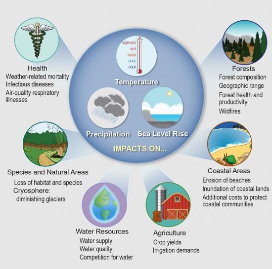
MEGHA-TROPIQUES
         A GREAT SUCCESS FOR NUMERICAL WEATHER PREDICTION

Consistent beneficial impacts of SAPHIR data found across 9 NWP centers, in particular on
Tropical wind forecasts (up to 4 days ahead) for centers using a 4D assimilation system.
    List of NWP centers assimilating SAPHIR data operationally
Numerical Weather Prediction Center                                     Assimilation Associated Publication
                                                                        method for
                                                                        SAPHIR
European Centre for Medium-Range Weather Forecasts (ECMWF)              All-sky      Chambon and Geer,
                                                                                     2017
Fleet Numerical Meteorology and Oceanography Center (FNMOC) – US Navy   Clear-sky    Jones et al., 2017;
                                                                                     Karpowicz et al., 2017
Japanese Meteorological Agency (JMA)                                    Clear-sky    Kazumori, 2016
Joined Center for Satellite Data Assimilation (JCSDA)                   Clear-sky   Jones et al., 2017
Korea Meteorological Administration (KMA)                               Clear-sky   Lee et al., 2018
Météo-France                                                            Clear-sky   Chambon et al., 2015

National Center for Environmental Prediction (NCEP)                     Clear-sky   Jones et al., 2017
Nationtal Centre for Medium Range Weather Forecasting (NCMRWF)          Clear-sky   Singh et al., 2017
UK Met Office                                                           Clear-sky   Doherty et al., 2018
                                                                                                       6
SARAL
                                     • Cooperation between CNES (France) and ISRO (India)
                                     • Launch date: February, 25th 2013
                                     • Nominal end of the mission: 2020
                                     Mission objectives: High-precision Altimetry and ARGOS
                                     •   The AltiKa altimeter provides a continuity to the ocean, inland water,
                                         sea and land ice topography time series that were initiated in the
                                         nineties with the ERS and ENVISAT missions from ESA
                                     •   The ARGOS3 payload complements the constellation which gives a
                                         precise localization of thousands of ARGOS beacons for a wide range
                                         of applications and carriers (e.g. ships, scientific boys, wildlife)

Main features of SARAL
•   Ka-band altimeter demonstrator: unique precision and
    resolution of the topography, wave height and wind-speed
    measurement
•   High quality of altimeter and radiometer corrections in
    coastal regions from instrument design
•   Unprecedented drifting orbit for very high precision
    geodetic products (e.g. bathymetry & mean sea surface)
                                                                                                       7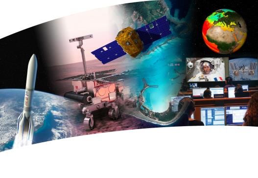
Value of Saral in the Ocean Surface Topography Virtual Constellation
Launc
h date
09 10 11 12 13 14 15 16 17 18 19 20 21 22
12/01 Jason-1 Francee/USA Jason-3 Europe/USA
Jason-CS A and B
06/08 Jason-2 Europe/USA
Europe/USA
3/02 ENVISAT Europe Sentinel-3A Europe (altimétrie, couleur, SST)
CRYOSAT-2 Europe Sentinel-3B Europe
Hy-2A China
SARAL France/India
SARAL in OST-VC
Key contribution to OST-VC
High latitude coverage
Filling the critical Gap between ENVISAT and Sentinel-3
Being developped (C/D) SARAL as a « world premiere » (Ka-band Altimetry) :
New capacities: coastal, inland, ice
Very good performance over oceans
Operational Asset for future missions : SWOT, SKIM …
TRISHNA
TRISHNA stands for : Thermal infRared Imaging Satellite
for High resolution Natural resource Assessment
Space borne mission dedicated to the remote sensing of our
planet in the thermal infrared (TIR) and visible part of the
electromagnetic spectrum :
at a high spatial scale (resolution of a few tens of meters)
at a high temporal scale (revisit of a few days)
with two main objectives driven by scientific requirements:
• Ecosystem stress and water use monitoring,
• Coastal areas monitoring and management.
Secondary objectives
• Urban
• Solid Earth
• Cryosphere
• Atmosphere
TRISHNA – Global Mission Requirements, System and Workshare
Mission main goals
Ecosystem stress and water use
Coastal and inland waters monitoring Observation Requirements
- High revisit & high spatial resolution for
Visible and Infrared observations
Thermal InfraRed Instrument TIR (CNES) - Global coverage
- Spectral Bands : 8,6µm / 9,1µm / 10,3µm / 11,5µm Sun Synchronous Orbit 761km @ 1PM
- CrGSD : 57m, 1000m over Open oceans 8-day cycle, 3-day revisit
- Cross-track view angle : +/- 34° 5 years lifetime
- 165kg, 245W, 1300*1000*550mm 3 Launch in 2024
Visible and Swir Instrument, VNIR (ISRO) Satellite (ISRO)
- Spectral Bands : - Three axis stabilized platform (IMS2)
485nm / 555nm / 650nm / 860nm & 1380nm / 1610nm - SADM
- GSD : 57m, 1000m over Open oceans - 320 Mbits/s Bande X
- Cross-track view angle : +/- 34° - Launcher : PSLV
- 30kg, 90W, 600*250*300mm3
Ground Segment (CNES & ISRO)
Current Status : - Ground control station & Operation: ISRO
• Mission definition review successful - TIR data processing up to level 2a : CNES
- VNIR data processing up to level 2a : ISRO
• Phase A decided : march 2018-July 2019
10
• Phase B/C/D/E1 objective : 2020-2024
• Launch objective : 2024SPACE CLIMATE OBSERVATORY - BACKGROUND
Potential effects of climate change
Source. Climate Change Impacts in the United States: The Third National Climate Assessment
20/11/2018
11The climate change…
International framework
…
Illustration by David Parkins
Nature 514, 30–31, Oct. 2014
One Planet Summit – Paris, December 11th, 2017
The SCO is one of the 12 One
SCO - UNOOSA - Bonn
Planet Summit commitments
20/11/2018Space Climate Observatory
Scope
Monitoring climate change
• Atmospheric CO2 concentration,
• Global temperature, Clouds and Precipitation change,
• Sea level rise, Droughts and floods…
Tracking the impacts of climate change
• Environmental impacts
• Social and human impacts
• Biodiversity reduction
• Economical costs
Mitigating and Adapting to climate change
• Resources: land use, agricultural practices, relocation, water use…
• Population: Migration of people, food security…
• Socio-economic development paths
SCO - UNOOSA - Bonn 20/11/2018Space Climate Observatory
Principles
Not alone !
A country, an agency, an institution…
could not make it for all the World/Planet
Involvement and cooperation of wide range of bodies
GEO, CEOS, CGMS and UN Agencies
National organizations, Ministries, local entities…
Political commitment requires from those partners
Co-construction
CO DESIGN
At level of populations
Metrics and social indicators to measure the appropriation and acceptance by stakeholders
Communities of development
Make available to others, freely
Exchange of use, best practice
Based on solid, open and state-of–the art scientific foundations
SCO - UNOOSA - BonnSpace Climate Observatory
Three Objectives
1 2 3
Information, Outreach Improve data access
(access – Interoperability – Free)
Products & Services
Communication, Learn
From Earth observations
Quality Control and
Validation Satellite data Toolkits and
computing capacities
ECV
Maps & Indicators
In-situ data
Research Government Traditional
& & & Scenarios
Education Society New Medias
Socio-economic
(past, present & future)
data
SCO - UNOOSA - Bonn 20/11/2018Space Climate Observatory
Access
National SCO Space Agencies International
Data Center Organization
National SCO
Products & Services
… …
but always
but always
SCO – HUB
Data access, Information, Products & associated Services
End Users
Next steps Jan. 2019 - First International meeting – Documentation
SCO - :UNOOSA - Bonn - partnership
20/11/2018
Mar. 2019 - Signature of an international charter/agreement, NairobiWHY IS INTERNATIONAL COLLABORATION SO IMPORTANT ?
17INTERNATIONAL COLLABORATION
• Climate change is a global issue. One single country / agency alone cannot address all the facets of the question :
space-based infrastructure, instruments, science, models, in-situ instruments, data processing and storage, …
International cooperation in Earth Observation is not important … it is mandatory
• Cooperation allows sharing the costs, taking the best (technology, science, infrastructure, …) of each partner in a win -
win partnership, enhancing the scientific and societal ROI by aggregating scientific and operational communities (1+1
> 2).
• A lot has been achieved over the past decades in various contexts :
• European construction : ESA, EUMETSAT
• Establishment of coordination groups (e.g. CEOS, CGMS, GCOS, GEO, GSICS, …)
• Success stories : A-Train, GPM constellation, Copernicus, coordination of GEO and LEO programmes between
EUMETSAT, NOAA, CMA, JMA, ...
• … but more should be done on :
• the infrastructure side (precipitation, water vapour, winds) – satellites + in-situ + models
• Making satellite products better known and easier to access, especially for non specialists
• Further integrating EO satellite data with other information such as model, in-situ, socio-economic data, in order
to allow informed decision at local level
18THANK YOU FOR YOUR ATTENTION
You can also read