Coastal Art Maps Capture Beauty of Idyllic East
               Coast Shoreline
←
→
Page content transcription
If your browser does not render page correctly, please read the page content below
Coastal Art Maps Capture Beauty of Idyllic East
Coast Shoreline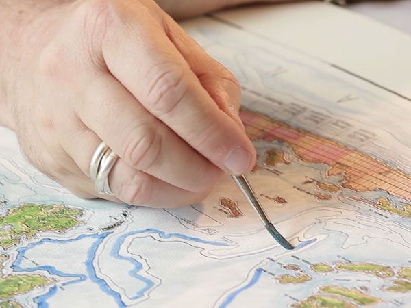
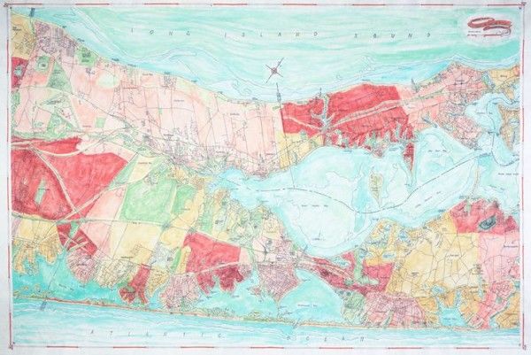
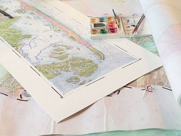
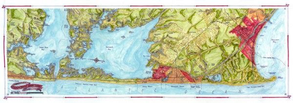
General Plan of Riverhead to Shelter Island, NY

Coastal Art Maps, a New York-based map-making enterprise, now offers an array of exquisite hand-
drawn maps commemorating the East Coast’s most beautiful beaches and islands from New England to
Florida. These breathtaking, collectible maps include the New York-New Jersey-Delaware shoreline
some of which was damaged by Superstorm Sandy, idyllic New England islands Martha’s Vineyard and
Nantucket, famous for their beaches, lighthouses, cobblestone streets, gray-shingled cottages, and
picturesque towns, and the iconic Florida Keys, spotlighting the broad varieties of land forms, inhabited
areas and vast natural wonders. Each of these breathtaking maps represent moments when an ever-
changing world was briefly frozen in time. These maps would make ideal, unique gifts for art
aficionados, beach lovers, historians, boating and fishing enthusiasts or anyone that has ever enjoyed
the beauty of these beloved seaside locales.

Artist Joseph S. Tarella, Owner of Coastal Art Maps, creates stunning artwork using the time-honored
tools of pen-and-ink and watercolor washes. The tactile quality that Tarella achieves by using ink and
watercolors on vellum allows for a kind of expression not easily achieved using more modern,
mechanical methods.
“These maps, singly or as a group, would make wonderful and informative keepsakes for the avid
sportsman, the casual naturalist or anyone familiar with the beautiful, water-centric American paradise
along the East Coast,” said Joseph S. Tarella. “They’d make gorgeous additions to any home or office
decor, and would be an unexpected, memorable and treasured gift for family, friends, colleagues or
clients.”

Tarella’s Massachusetts maps spotlight the beauty of two New England island locales, which are rife with
history. Located south of the Massachusetts/Cape Cod coastline, they face out to the Atlantic Ocean and
have launched thousands of ships from their well-protected harbors. Long at the center of the lucrative
whaling industry, the islands were home to industrious and prosperous sea-farers and now are among
the most popular summertime destinations in the area.

The Florida Keys maps, rendered in the well known natural divisions of Upper, Middle and Lower Keys,
vividly present the many, varied isles, linked by the Overseas Highway, within the vast watery
background of the southernmost part of the country. Each map represents approximately 25 miles and
richly depicts the broad varieties of land forms, inhabited areas and vast natural wonders.
Coastal Art Maps also captures the magic of the coastline between Massachusetts and Florida, with rich,
robust images of New York’s Fire Island, Shelter Island and Montauk, New Jersey’s Sandy Hook and Long
Beach Island, Atlantic City and Cape May, Delaware’s Rehoboth and Bethany beaches, Maryland’s
beloved Ocean City and more.

“Coastal Art Maps started as a hobby. I have always liked maps and traveling, and when I built a house
on Long Beach Island, I couldn’t find any maps of the area that I liked, so I created my own,” Tarella
explained. “When my friends and neighbors saw the maps I’d created, they loved them and wanted
their own versions. The labor-of-love endeavor evolved from there.”

“Since creating that first map of my Long Island Beach hometown, I’ve crafted maps of other, treasured
East Coast locales, often based on customers’ requests,” Tarella continued. “From Nantucket to Key
West, I’ve enjoyed exploring the exceptional details of our East Coast shorelines, capturing these
breathtaking treasures for current and future generations to enjoy.”

Artist Joseph Tarella offers a series of limited-edition art maps of selected coastlines. Each map presents
an elegant, detailed and accurate rendering of selections of East Coast land areas, highlighting their
juxtaposition and relationships between land and water, islands, parks, roadways, and other significant
elements. These comprehensive and beautiful ink-and-watercolor compositions, offered on full size
giclee canvas or half-size watercolor paper, make a truly unique and satisfying acquisition.

    Rehoboth Beach Sussex Shores

Tarella combines his architectural experience, passion for travel and love of map-making to create
stunning maps of East Coast beaches. Coastal Art Maps currently has 18 different maps in circulation,
depicting areas including the New York, New Jersey, Maryland, Delaware and Florida coastlines. Tarella,
a trained architect and co-owner of SawickiTarella Architecture+Design PC, also customizes maps,
identifying specific locations, per customer request.

Breathtaking, Hand-drawn Maps Represent Moments in an Ever-Changing World – Make Great Gifts for
Collectors, Beach & Nautical Enthusiasts, Dads & Grads, Etc.

         For more information, please visit www.coastalartmaps.com

0 Comments

This entry was posted in Beach Cottage Decor and tagged art, Beach gift, coastal art, Coastal Maps, East
Coast, Maps, Shoreline, Unique Gift, wall art on March 28, 2014
[http://nauticalcottageblog.com/2014/03/coastal-art-maps-capture-beauty-idyllic-east-coast-shoreline/]
by Sally Lee by the Sea, LLC.

About Sally Lee by the Sea, LLC
Sally Lee by the Sea ~ a beach cottage design & coastal lifestyle site.
View all posts by Sally Lee by the Sea, LLC →
You can also read