Coastal Vulnerability Assessment of Saint-Louis /Senegal to Sea Level Rise
←
→
Page content transcription
If your browser does not render page correctly, please read the page content below
GSJ: Volume 9, Issue 1, January 2021
ISSN 2320-9186 213

 GSJ: Volume 9, Issue 1, January 2021, Online: ISSN 2320-9186
 www.globalscientificjournal.com

Coastal Vulnerability Assessment of Saint-Louis /Senegal to Sea Level Rise

 Koulibaly Cheikh Tidiane¹; Ayoade Johnson.O²; Adelekan Ibidun.O²

¹Pan African University, Institute of Life and Earth Sciences (PAULESI), University of Ibadan, Ibadan, Nigeria

 ²University of Ibadan, Ibadan, Nigeria

Corresponding Author: tidianecheikh90@yahoo.fr

Abstract
Sea level rise is one of the most certain effect of global warming with serious consequences
on coastal ecosystems and local communities. The physical impacts are obviously related to
such disasters as coastal erosion, inundations and displacement of low lands like deltas and
estuaries. Estuarine ecosystems are both subject to marine and fluvial dynamic; they are
endowed with rich biological diversity but actually facing disastrous effects of climate change
(inundation, coastal erosion, and salinization) and anthropogenic activities (infrastructures
and over exploitation of resources). This study is aimed at assessing vulnerability of Saint-
Louis (Senegal River estuary) through the Coastal Vulnerability Index model and GIS based
analysis. It involved the combination of a set of both physical and geological variables.
Physical factors include the geomorphology of the area, shoreline change rate and coastal
slope while geological parameters were more or less related to sea level rise, tidal range and
wave height. Data were acquired from different sources: geomorphologic information was
provided by extensive literature review and onsite direct observation; coastline change
analysis from 1978-2018 was done using Landsat images (Multispectral Sensor: Landsat 1, 2,
3), TM (Thematic Mapper: Landsat 4 and 5), ETM+ (Ehanced Thematic Mapper: Landsat 7)
and OLI and TIRS (Operation Land Imager/ Thermal Infrared Radiation: Landsat 8) and the
Digital Shoreline Analysis System; while coastal slopes were extracted from an SRTM
(Shuttle Radar Topography Map) of 1 Arc-Second Global Elevation Data (30m resolution)
obtained from USGS platform. However, geological data from 2008-2018 were acquired from
NOAA (National Oceanographic and Atmospheric Administration) and UHSLC (University
of Haiwai Sea Level Center).The Coastal Vulnerability Index model was used n this study.
Results show that 25.98% of the coast was at low vulnerability, 1.49% at moderate while

 GSJ© 2021
 www.globalscientificjournal.com
GSJ: Volume 9, Issue 1, January 2021
ISSN 2320-9186 214

42.9% of the shoreline was classified as high vulnerability and 29.58% as very high
vulnerability. Given these outputs, the study also examined adaptation strategies and
measures put in place by local communities and authorities to face coastal disasters.

Key Words: Estuary, Erosion, Coastal Vulnerability, Adaptation,

Study Background
Vulnerability has been defined as the variable propensity of a given society to undergo
damages arising from the manifestation of a natural or anthropogenic phenomenon (D’Ercole
1994). In this context the concept is defined as "vulnerability in the broad sense" as opposed
to the more strict and applied sense. Therefore, vulnerability of communities and human
activities to natural hazards or environmental problems is a significant phenomenon of what is
today recognized as a "risk society" (Beck, 2001) or a vulnerable society (Fabiani, Theys,
1987), where the IPCC assimilated it to “The degree to which a system is susceptible to, and
unable to cope with the effects of climate change, including climate variability and extremes.
Vulnerability is function of the character, magnitude, and rate of climate change and variation
to which a system is exposed, its sensitivity, and its adaptive capacity”. The Earth Summit
(Rio de Janeiro, June, 1992) marked the rise of awareness about climate Change and its
repercussions Worldwide. Nowadays, there is scientific consensus, based on an
overwhelming body of evidence, that global climate is changing. In coastal areas Climate
change is expected to result in a rising sea level and increase of the frequency and the
intensity of extreme weather events with significant impacts on coastal communities and
ecosystems.
In West Africa, the main concerns of coastal areas stem from the degradation of biodiversity
and coastal habitats, due to pollution, seawater intrusion and coastal erosion. In addition, the
construction of dams leads to a reduction in the volume of fresh water and decrease in
sediments likely to be discharged toward the coast. Senegal is a West African country widely
open to the Atlantic Ocean with 700km of coastline. This area is structured around the Cape
Verde peninsula and three mouths represented by the Senegal River, the Sine Saloum and the
Casamance which form estuarine environments with very rich and varied ecosystems.
However, this coastline is increasingly subject to anthropogenic pressure and other natural
phenomena such as sea level rise, erosion, salinization, degradation of natural habitats. The
Senegal River estuary runs through the flat and quasi flooded region of Saint-Louis, and
separated from the ocean by the “Langue de Barbarie” Sand strip of about thirty kilometers
stretching from north to south of Saint-Louis, from the Mauritanian border to the mouth of the
Senegal River. The Langue de Barbarie constitutes the main buffer area with the Atlantic and
is housing since centuries the conservative fishermen communities of Guet-Ndar and
 GSJ© 2021
 www.globalscientificjournal.com
GSJ: Volume 9, Issue 1, January 2021
ISSN 2320-9186 215

Goxxumbacc.
Today the future of the Langue de Barbarie is quite uncertain because of ecological
disturbances with huge degradation of natural habitats and infrastructures emanating from sea
level rise and resulting coastal erosion and flooding. Based on the examination of old maps, a
decline of 4000 m from the coast of the Langue de Barbarie to the right of St. Louis was noted
between 1660 and 1922 with a corresponding rate of 15 m per year (Barbey, 1967). From
1856-1926, measurements made from benchmarks showed a beach retreat of St. Louis of
about 125 m in 70 years (Guilcher and Nicolas 1954), corresponding to an average annual
decline of 1.8 m. In 1975 a beach retreat of 1,2m had been recorded while this rate shifted to
3,2m in 1989 (DEEC, 2005). “The city is already subject to significant risk of river flooding,
which would intensify with sea level rise, impeding the outflow of river water into the ocean
such that by 2080, 80 percent of the city could be submerged annually” (World Bank, 2013).
According to (Dia,2000), the high degree of vulnerability of the city of Saint-Louis can be
mainly attributed to extensive low lying coastal area, high population density, high rate of
coastal environment degradation. Serious erosion has been observed on a local scale. Some
elderly people of the local communities mentioned that the beach used to be much wider
when they were young. Since the opening of the new mouth in 2003, the lower estuary is
often subject to serious erosion disturbing the ecological system and inducing both loss of
human settlements and economic assets as experienced by the populations of the village Doun
Baba Dieye. In 1994, the advancing sea and flooding caused displacement of the village
“Keur Barka” to the present site. Today, the original site is occupied by mangroves.
According to (Kane.C 2010), 8 houses had been abandoned to the sea in 2007, the following
year; more damages had been recorded in about 10 houses, in 2009; 3 houses uprooted by the
sea and the number shifted to 20 houses destroyed and about 52 families displaced or
relocated in 2010. Despite various interventions or logistics, real solutions or mitigation
measures are yet to be felt while the situation is worsening. However, the majority of studies
carried out so far in Saint-Louis were mostly based on deterministic approaches aimed at
quantifying coastal erosion using Non Rectified Arial Photographs, Cadastral Maps as well as
Topographic and socioeconomic surveys. Till now there is no evaluation of the physical or
socioeconomic vulnerability of Saint-Louis to sea level rise even if in 2006, Senegal launched
its National Adaptation Plan to Climate Change aimed at identifying vulnerabilities and
needs of urgent and effective adaptations measures to Climate Change with particular
attention given to coastal areas. This study arise then from the need of analyzing and
mapping vulnerability of the Senegal River estuary (Saint-Louis) by proposing a newer
approach based on the CVI model.

 GSJ© 2021
 www.globalscientificjournal.com
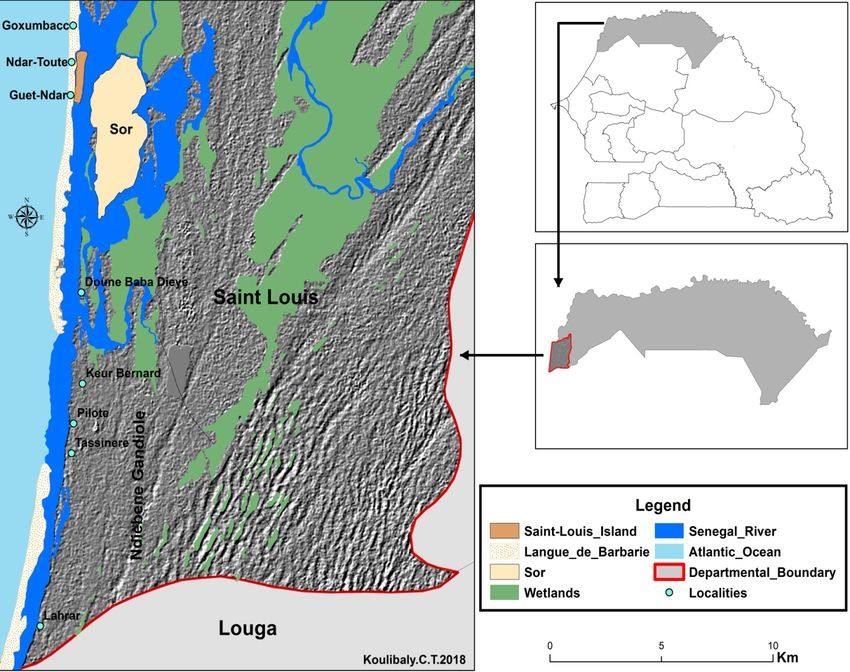
GSJ: Volume 9, Issue 1, January 2021
ISSN 2320-9186 216

Methodology
Study area
Our study area concerns the locality of Saint-Louis or Ndar in Wolof. Former capital of the
Senegalese French colony from 1673 to 1902, Saint Louis is located along the northwest coast
of Senegal. The Senegal River estuary is located over there and specifically covers the
geographical area between the Diama dam and the sandy sprit of langue de Barbarie, the end
of which marks the position of the mouth of the Senegal River. It is a potentially rich area
with varied ecosystems and diverse economic activities subject to the influence of particular
hydrological factors, including the mix up of fresh and saline marine waters.

Figure 1: Location of Saint-Louis and coastal localities

The relief is made up of sand dunes and depressions which formerly constituted drained
valleys. The coastal morphology is globally represented by recent white sand dunes dated
from the sub-current to present (2,000 to 1,800 BP). These deposits, also known as coastal
dunes or living dunes, are characterized by their mobility strongly influenced by the littoral
drift. They are north-south oriented and parallel to the coast. The Langue de Barbarie sand
strip is totally made up of these white dunes of 200 m to 400 m widths and forms a line

 GSJ© 2021
 www.globalscientificjournal.com
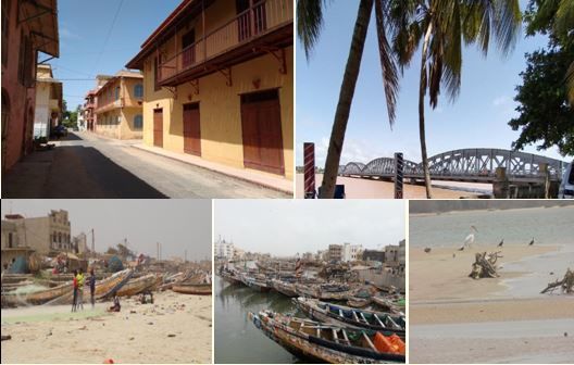
GSJ: Volume 9, Issue 1, January 2021
ISSN 2320-9186 217

between the ocean and the Senegal River (Seye, 2005). The vegetation is poorly developed
and mainly represented by halophil species thanks to the coastal environment. The area is also
marked by moderate temperatures with maximums around 28 ° C in July and August and
minimums of 18 ° C from November to February (Sall et al. 2011).Like the whole country,
Saint-Louis is subject to the alternation of a rainy season from July to September and a dry
season from October to June. However in this particular area of the country, rainfall rarely
exceeds 350 mm per year with a recent observed decrease due to climatic disturbances.
Wolofs 1 tribes mainly “Lebous 2” fishermen are the major dwellers of Saint-Louis and occupy
the Northern and populated part of the Langue de Barbarie; Fulas 3 and Moors 4 are also
represented in the area; they are usually farmers and livestock breeders located in the lower
estuary so called the Gandiolais. Economically, fishing and agriculture remain the major
traditional activities since independence (1960). Widely opened to the Atlantic Ocean, Saint-
Louis houses the third largest fishing harbor in Senegal and plays a key role in food security
and economy generating. Categorized Unesco Site in 2000, the locality is of huge tourism
potential because it preserved remarkable colonial architecture illustrated by the variety of
colors of old buildings including alternation of wooden and iron balconies with the decorated
doors and windows frames and the double-pitched roofs covered with red tiles. Moreover, the
area is also hosts amazing estuarine landscape attracting several species of migratory birds
and marine turtles.

1
 Wolofs are an ethnic group located in Senegal, The Gambia, and Mauritania. In Senegal, close to 44% of the
population declare themselves Wolof. This tribe, made of farmers, fishermen and traders mainly occupies the
northwestern regions of Senegal.
2
 Assimilated as a sub-group of the Wolof tribe, the Lebous a community mainly concentrated in the Cape Verde
peninsula (Dakar) since 1430, they are also located throughout the Northern coast of Senegal. They are
traditionally fishermen although a minority also practices agriculture.
3
 Fulas or Fulani are ethnic groups located in more than twenty West African countries. Predominantly nomad
hedersmen, their mobility favored exchanges and interbreeding with other populations.
4
 Originated from the Western Sahara regions, moors are mainly established in the northern regions of Senegal.
Livestock breeding is their main activity.

 GSJ© 2021
 www.globalscientificjournal.com
GSJ: Volume 9, Issue 1, January 2021
ISSN 2320-9186 218

Plate 1: Environment of Saint-Louis with Colonial Buildings, Faidherb Bridge, fishing
activity and the Lower estuary

Data Acquisition
This study on coastal vulnerability involved the analysis and combination of various data
acquired from diverse sources. Both primary and secondary information were used. The
primary information was acquired from the field through visits, interviews, onsite
observation, GPS mapping and photographs.

The secondary information mainly concerned geospatial data as:
- Digital elevation models/ topographical maps such as SRTM (Shuttle Radar Topography
Map) of 1 Arc-Second Global Elevation Data (30m of resolution). The SRTM was mainly
used to extract elevations and slope values for the completion of our study.
-Satellite Landsat imageries of different dates: 1978, 1988, 1998, 2008, and 2018 by MSS
(Multispectral Sensor: Landsat 1, 2, 3), TM (Thematic Mapper: Landsat 4 and 5), ETM+
(Enhanced Thematic Mapper: Landsat 7) and OLI and TIRS (Operation Land Imager/
Thermal Infrared Radiation: Landsat 8) from the United States Geological Survey platform
were also used to extract shorelines and then run shoreline change analysis using DSAS
(Digital Shoreline Analysis System) in Arcgis10.1.

 GSJ© 2021
 www.globalscientificjournal.com
GSJ: Volume 9, Issue 1, January 2021
ISSN 2320-9186 219

 Date of Sensor Resolution Path/Row Cell Coordinate Zone
acquisition (m) size(m) system/Datum
1978-06- LANDSAT_3/MSS 60 221/49 60/60 UTM/WGS84 28
19
1988-03- LANDSAT_4/TM 30 205/49 30/30 UTM/WGS84 28
01
1998-02- LANDSAT_5/TM 30 205/49 30/30 UTM/WGS84 28
26
2008-01- LANDSAT_7/ETM+ 30 205/49 30/30 UTM/WGS84 28
29
2018-01- LANDSAT_8/OLI 30 205/49 30/30 UTM/WGS84 28
16
2014-23- SRTM 30 - 30/30 UTM/WGS84 28
09

Table1: Details of Landsat and DEM used in the study
-The last set of information was about the geomorphology of the area as well as geological
parameters such as sea level rise, the tidal range and wave height. The information on the
geomorphology of our study area was provided by an extensive literature review and onsite
observation while oceanographic information were generously obtained and calculated from
such platforms as (National Oceanographic and Atmospheric Administration) and UHSLC
(University of Haiwai Sea Level Center).

Data Analysis
The determination of the coastal vulnerability index both required a statistical and geospatial
analysis of obtained data. Quantitative and deterministic approaches of coastal hazards
assessment are widely used in mapping physical vulnerability of coastal areas. These methods
are mainly based on direct and deterministic quantification of how the coast will be eroded
and / or flooded under a given assumption of a sea level rise. However, it is important to
emphasize that coastal systems are too complex to be modeled deterministically over time;
where the need of multi-criteria approaches leading to the assessment of physical
vulnerability based on a number of indicators: geomorphology, topography, oceanography,
etc. The coastal vulnerability index is a multi-criteria model proposed and used for the first
time by Gornitz (1990, 1991) in the study of the physical vulnerability of US coasts to sea
level rise. It involves a numerical and cartographical approach used in the classification of
different sections of the coastline in term of potential damages emanating from climate
change. This study is based on a CVI model developed by Thieler & Hammar-Klose (1999)
and similar to that used by Gornitz (1994) which involved the combination of six key
variables that influence the coastline evolution of a designated area:

 • The Geomorphology of the area

 GSJ© 2021
 www.globalscientificjournal.com
GSJ: Volume 9, Issue 1, January 2021
 ISSN 2320-9186 220

 • The Coastal Slope
 • The Relative Sea Level Rate
 • The Shoreline Rate Rates changes(Erosion/Accretion)
 • The Mean Tidal Range
 • The Significant Waves Height

 Each of these Variables is given risk values and each value is assigned to a particular scale
 ranging from 1 (Very Low) to 5 (Very High) as described in the table below:

 CVI Ranking
 Very Low Low Moderate High Very High
Variable 1 2 3 4 5
 Rocky, Medium Low cliffs, Cobble Beach
 cliffed cliffs, Glacial beaches, barriers
Geomorphology coasts, Indented drift, Estuary , ,Sand
 fiords, coasts Alluvial Lagoon Beaches Salt
 fiards plains Marsh, Mud
 flat, Delta,
 Mangrove,
 Coral reefs
Coastal Slope (%) > 0.2 0.2 - 0.07 0.07 - 0.04 0.04 - 0.025 < 0.025

Relative Sea level change < 1.8 1.8 – 2.5 2.5 - 2.95 2.95 – 3.16 > 3.16
(mm/year)
Shoreline erosion/accretion >2.0 1.0 - 2.0 -1.0 - +1.0 -1.1 - -2 < -2
(m/yr) Accretion Stable Erosion
Mean tide range (m) >6 4.1 - 6 2.0 - 4 1.0 – 1.9 < 1.0

Mean wave height (m) < 0.55 0.55 – 0.85 0.85 – 1.05 1.05 – 1.25 > 1.25

 Table 2: CVI Ranking (Thieler & Hammar-Klose 1999)

 All of these information items are incorporated in a GIS data base and assigned to the
 concerned coastline; the calculation was done through ArcGis statistical tool. The CVI
 provides by a quantitative estimation of the physical vulnerability given by the following
 formula:

 CVI=�( × × × × × )/ ,

 Where:

 a. Geomorphology of the area
 b. Coastal Slope (%)

 GSJ© 2021
 www.globalscientificjournal.com
GSJ: Volume 9, Issue 1, January 2021
ISSN 2320-9186 221

 c. Relative Sea Level Rate (mm/year)
 d. Shoreline Rate changes : Erosion/Accretion (m/year)
 e. Mean Tidal Range (m)
 f. Significant Waves Height (m)

The calculation and mapping of the CVI needed to build a strong GIS data base putting
together all variables in an attribute table. These CVI variables were differently analyzed:

-The Geomorphology: the geomorphology of the area was analyzed through extensive
literature review. It was mainly focused on studies on the Langue de Barbarie sand strip and
based on the geomorphological classification scale of the CVI model.

-Coastal Slope: It involved the GIS analysis of an SRTM (Shuttle Radar Topography Map)
of 1 Arc-Second Global Elevation Data (30m of resolution) acquired from the United States
Geological Survey platform. The SRTM was projected in UTM (Universe Transverse
Mercato), ZONE 28N referred to the WGS 84 (World Geodetic System 1984) and slopes
were extracted through the “Spatial analyst tool” of ArcGis10.1 and expressed in percentage
(%). The slope analysis was also focused on the whole Langue de Barbarie sand sprit and then
classified and mapped at the convenient scale showing the areas with gentle slopes and those
with steep slopes before being assigned and joined to the coastline for CVI calculation.
Finally, an area analysis was also done using “zonal statistics as table” tool which provided
and calculation of areas (Ha) occupied by each slope value across the study area.

-Relative Sea Level Rise: Sea level rise was estimated from fast delivery data of the tidal
gauge of Dakar acquired from UHSLC (University of Haiwai Sea Level Center) through its
station 223. These data mainly involved hourly and daily tides excel sheets from 2008 to
2018. After verification, daily, monthly and then annual means were calculated using Excel
and a trend has been determined to estimate sea level rise through linear regression function
(y= ax + b).

-Shoreline erosion and accretion: the most critical stage of the study, was calculated from
1978 to 2018 and were analyzed and mapped using satellite Landsat imageries of different
dates: 1978, 1988, 1998, 2008, and 2018 through the Digital Shoreline Analysis System
(DSAS) in Arc Gis 10.1. Composites were created and images were geometrically verified
before extracting coastlines using land/water interface detection techniques. In this study,
unsupervised and supervised classification was used to create from composites a binary image
of 2 classes (land and water) showing clear separation of immerged and emerge bodies. The
raster image was then converted into vectors and shorelines were extracted through digitizing

 GSJ© 2021
 www.globalscientificjournal.com
GSJ: Volume 9, Issue 1, January 2021
ISSN 2320-9186 222

process. Coastlines from different dates were then put together and then transects were built
and change rate calculated from DSAS using the LRR (Linear Regression Rate) as calculation
method. The annual Error (E) was finally determined using the following formula elaborated
by (Hapke et al., 2006) based on landsat imaged uncertainties and time:

 �d₁²+d₂²
 E= Where d1 and d2 represent the estimated uncertainties of
 T
the different Landsat images and T is the time (years) elapsed between images. In this study,
the annual Error (E) ranges from ±1.8 to ±2.2 m/year.

-The Mean tide range: The mean tide was also calculated using the fast delivery tidal data
provided by UHSLC through its station 223 from 2008-2018. The tidal range was then
determined from the calculated annual tidal means by the difference between extreme
maximum and extreme minimum water level.

-Mean Wave Height: wave heights (Hs) of 2008-2018 were extracted from WW3 (Wave
watch 3) model acquired from NOAA (National Oceanographic and Atmospheric
Administration). Daily data were provided in Grb2 format and extracted through XyGrib-
1.2.6 software and conserved in excel sheets before being combined together and sent into
ArcGis 10.1 statistical tool for mean weight calculation and graph generation.

Results and Discussion
The results of our multiple analyses are presented for each variable and then finally combined
to provide the CVI of our study area.

Geomorphology
The coastal geomorphology of the Senegal River estuary is mainly characterized by a Sand
strip of about 30 Km length called Langue de Barbarie generally made of white colored sand
dunes system that took place after the Nouackchottien marine transgression. These dunes
stand between the sandy beach and the semi fixed dunes located inland. These formations
bear sandy soils called “raw intake soils”, composed of material resulting from a mixture of
quartz and limestone. According to Nicolas (1953) this sand strip is geomorphologically
divided into 3 different zones: a maritime zone or external shore under the influence of marine
dynamics dominated by erosion process; a intermediary stable wind turbine zone (high beach
and vivid coastal dunes) under the influence of the wind; a fluvial zone or internal shore
dependent on fluvial dynamics where sedimentation is more felt. The morphological dynamic
is driven by the phenomenon of erosion and sedimentation. Marine dynamics play a key role

 GSJ© 2021
 www.globalscientificjournal.com
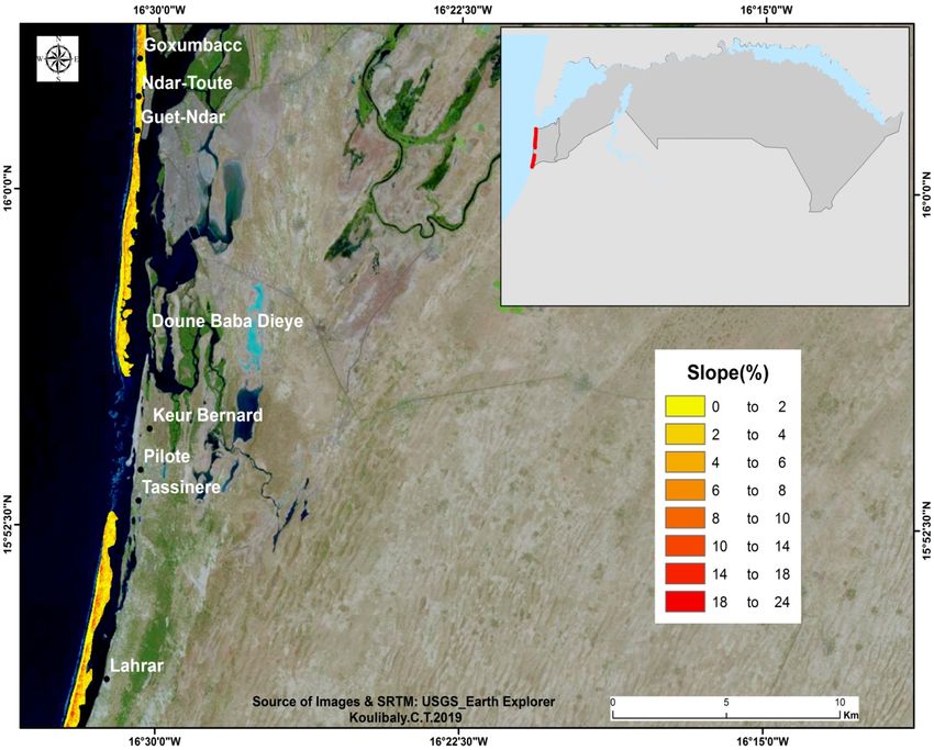
GSJ: Volume 9, Issue 1, January 2021
ISSN 2320-9186 223

in the construction and erosion of the coastline. In fact, approximately 600,000m3 of sand are
brought annually to the southern end of the Langue de Barbarie (Kane, 1997). Fluvial inflows
shape the internal shore by erosion phenomena, especially during flood periods, this erosion
being today more significant depending on the retention of the Diama dam (Kane, 1997).It is
also important to emphasize that the estuary is also occupied in some of its part by mangrove
ecosystems but at a limited scale because of their actual state of degradation mainly due to
hydrological disturbances since the erection of the Diama dam.
According to the coastal vulnerability index of geomorphological variables our study area can
be ranked 5 meaning “very High Risk”. Even if it is an estuary, it is essentially made of sandy
beaches and some mangrove swamp forest including salt marshes.

 CVI Ranking
 Very Low Low Moderate High Very High
 1 2 3 4 5
 Rocky, Medium Low cliffs, Cobble Beach
 cliffed cliffs, Glacial drift, beaches, barriers
Geomorphology coasts, Indented Alluvial Estuary , ,Sand
 fiords, fiards coasts plains Lagoon Beaches Salt
 Marsh, Mud
 flat, Delta,
 Mangrove,
 Coral reefs

Table 3: CVI ranking of geomorphological variable of the study area

Coastal Slope
Coastal slopes were extracted from a Digital Elevation Model (Shuttle Radar Topography
Map) of 1 Arc-Second Global Elevation Data (30m of resolution) and analyzed in 2 ways: the
first one involved a global analysis of slopes across the Langue de Barbarie sand strip based
on surfaces (Ha), the second one was focused on the main beach and based on the length by
spatially joining slope values to the coastline.

 GSJ© 2021
 www.globalscientificjournal.com
GSJ: Volume 9, Issue 1, January 2021
ISSN 2320-9186 224

Figure 2: Spatial distribution of slope across the “Langue de Barbarie”

Figure 3: Spatial variation of slopes values across the “Langue de Barbarie”

Figure 2 and 3 show the global distribution of extracted and classified slope values throughout
the Langue de Barbarie Sand strip. It reveals that more than 442.62 Ha of the area is occupied
by slopes of 0-2 %, 293.67 Ha by slope values of 2-4%, 136.98 Ha surfaces of 4-6% slopes
and 68.49 Ha occupied by slope ranging from 6-8 % while values from 8-10%, 10-14%, 14-

 GSJ© 2021
 www.globalscientificjournal.com
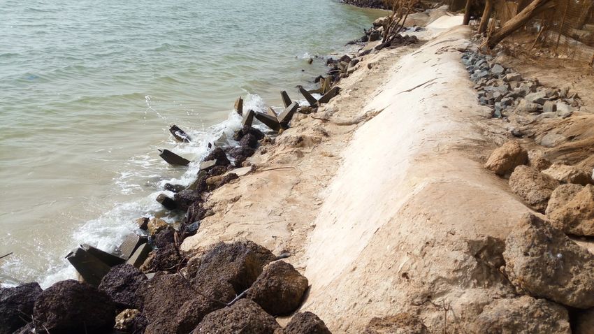
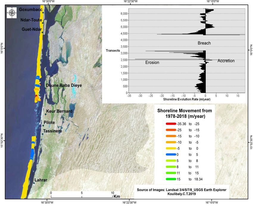
GSJ: Volume 9, Issue 1, January 2021
ISSN 2320-9186 225

18% and 18-24% respectively occupy 31.86 Ha, 19.44 Ha, 3.96 Ha and 0.81. This situation
attests the flatness of Saint-Louis where gentle slopes globally occupied close to 94% of the
total area.

Toward the main beach, the spatial join of slope value to the coastline revealed that 19.130
km of the coastal length is occupied by the value 0%, 1.570 Km by 1%, 0.883 Km by 2% and
8.022Km by values beyond 2%. This shows in percentage that in the main beach, 64.6% of
the coastline is level (slope value of 0%) attesting that the majority of the coastline is at high
risk.

Relative Sea Level change
Relative sea level change was calculated from Dakar tidal gauge observations from 2008-
2018.

 1100

 1090

 1080

 1070

 1060

 1050

 1040
 y = 1.1367x + 1057.8
 1030

 1020
 200

 200

 201

 201

 201

 201

 201

 201

 201

 201

 201
 8

 9

 0

 1

 2

 3

 4

 5

 6

 7

 8

Figure 4: Sea Level change from 2008-2018

Analysis from tidal gauges observation estimated that from 2008-2018, the sea level rose by
1.13mm/year. However, the preliminary estimations of Woppelman (2008) based on a long
term linear trend (100 years) yielded a value of 1.44mm of sea level rise over the past hundred
years. This situation attests an ongoing and non neglectable rising sea but till now classified
as low vulnerability by the CVI model used in this study.

Shoreline erosion/accretion (m/year)
Shoreline change analysis done through DSAS(Digital Shoreline Analysis System) revealed
that from 1978-2018 the coastline was subject to a mean shoreline change rate of -1.31m/year
showing a important beach retreat accompanied with serious sedimentary deficit.

 GSJ© 2021
 www.globalscientificjournal.com
GSJ: Volume 9, Issue 1, January 2021
ISSN 2320-9186 226

Figure 5: Shoreline erosion/accretion from 1978-2018

From the considered period, both phenomenon of erosion and accretion were recorded across
the coastline. The rate of coastal erosion ranged from -0.1m to -35.36 m/year while accretion
rate varied from 0.11 to 18.34m/year. The processes were marked with strong spatial
variability, some areas located northward such as the fishermen villages of Guet-Ndar, Ndar
Toute and Goxumbacc were respectively affected with shoreline retreat of -1.53m/year
(Guet-Ndar), -2.94m/year (Ndar Toute) and -1.9m/year (Goxxumbacc) while the highest rates
of erosion (-9.39 to 35 m/year) have been recorded around the new mouth also known as the
“Breach” commonly called “Beul bi” by locals. The process of erosion is also taking place in
the south as the new mouth is evolving southward with coastline retreat ranging from -0.94 to
-1.17m/year. Rare phenomenon of accretion is located down the center and in the south
varying from 0.55 to 18m/year.

Mean Tide Range (m)
Tidal range was calculated from hourly and daily tidal gauges fast delivery data provided by
the station 223 from 2008-2018. From the considered period the calculated tidal range was
estimated at 0.045m which was ranked “Very High” vulnerability by the CVI model.

 GSJ© 2021
 www.globalscientificjournal.com
GSJ: Volume 9, Issue 1, January 2021
ISSN 2320-9186 227

Mean Wave height (m)
Wave height analysis from acquired Wave Watch III (WWIII) model from 2008-2018
revealed a maximum wave height of 4.6m by a minimum of 0.7m.

Figure 6: Wave Height from 2008-2018

Over the considered period the mean wave height was estimated at 1.76m revealing “very
high” vulnerability of the coastline from 2008-2018.

Coastal Vulnerability Index in 2018
The major aim of this study is to assess a coastal vulnerability of the Saint-Louis in 2018. The
six ranked variables were assigned to the coastline in a GIS database and CVI was calculated
using the formula. Categorization from Low-Moderate-High-Very High vulnerability was
done using 4 equal intervals and each CVI value falls in its relevant interval. In this study, the
calculated CVI ranges from 7.90 to 22.82 with a mean of 15.45 and a standard deviation 4.22.
Values from 7.90 to 11.63 were assigned to low vulnerability. Moderate vulnerability values
lie from 11.64-15.36. Values from 15.37-19.09 were classified as High Vulnerability and CVI
values greater than 19.09 were categorized very high vulnerability.

 GSJ© 2021
 www.globalscientificjournal.com
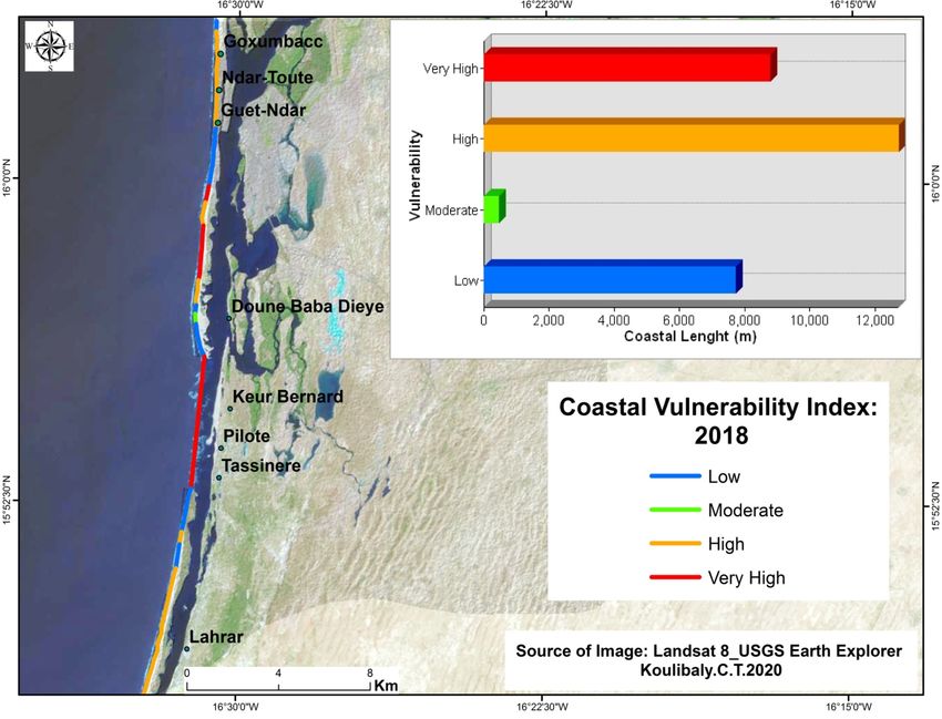
GSJ: Volume 9, Issue 1, January 2021
ISSN 2320-9186 228

Figure 7: Coastal Vulnerability Index of Saint Louis

In this map of the CVI, blue refers to areas at low vulnerability, green represents moderate
vulnerability, orange refers to zones at high risk and red was assigned to area at very high
vulnerability.

 Figure 8: Vulnerability according to coastal length

Projected to the coastline length, it appears that 7,692 m of the coastline is at low
vulnerability, 442.72 m at moderate vulnerability. It also appears that the majority of the

 GSJ© 2021
 www.globalscientificjournal.com
GSJ: Volume 9, Issue 1, January 2021
ISSN 2320-9186 229

coastline has been classified at high and very high vulnerability with respectively 12,711.9 m
and 8.758.9m. In terms of percentages the results showed that 25.98% of the coastline has
been classified as low vulnerability, 1.49% at moderate vulnerability, about 43% categorized
at high vulnerability and 29.58% as very high vulnerability.

 Figure 9: Vulnerability of coastline length in percentage

This analysis shows that more than 70% of the coast is highly vulnerable. The provided map
showed that the major areas of high and very high vulnerability were mainly the 2 populous
fishermen villages of Guet-Ndar, Goxxumbacc as well as the area of the new mouth and the
south south around the village of Lakhrar. This high level of vulnerability of the coastline
both emanates from natural and anthropogenic factors.

The first driver of the vulnerability of the Senegal River estuary remains the natural terrain:
the area is relatively flat and made of sandy shores characterized by gentle slopes. As attested
by our analysis, about 64.6% of the main beach is level ( slope value =0%) while at the global
view about 94% of the Langue de Barbarie sand sprit is occupied by gentle slopes (0-9%).
Commensurately, a second analysis of the DEM based on elevation (m) across the whole
department of Saint-Louis revealed that 8.02% of the entire area is below the sea level (-13-
0m) and about 73% from 0-10m making the estuary vulnerable to such events as storm
surges, coastal erosion and inundation. In addition to this, the coastal zone is
geomorphologically made of coastal plains with sand dunes deposits highly subject to
erosion. Like all estuaries, Saint-Louis is both subject to marine and fluvial dynamics. Over
the last decades it had been observed that the marine dynamic is becoming more aggressive
and agitated. From 2008 to 2018 an amazing Mean wave height of 1.76m with swells

 GSJ© 2021
 www.globalscientificjournal.com
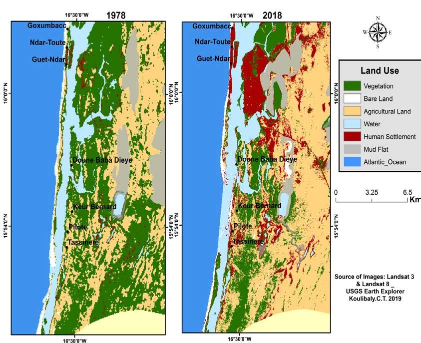
GSJ: Volume 9, Issue 1, January 2021
ISSN 2320-9186 230

frequently reaching 4 m in addition to an extreme tidal range of 0.045m were recorded
attesting to a state of high vulnerability ever with frequent storm surges and serious damages
on local communities and their environment.

The second set of drivers concerns anthropogenic factors, including high density population,
poor urbanization and resilient infrastructures. The coastal area of Saint Louis has obviously
recorded an exponential population growth caused by rapid occupation of the three core parts
of the city as the Langue de Barbarie, the “Saint Louis Island” and the main land “Sor”. A
land use analysis done with LANDSAT_3/MSS (1978) and LANDSAT_8/OLI (2018)
through ArcGIS10.1 revealed that areas occupied by human settlements from 1978 to 2018
have been multiplied by almost 9 and passed from 599.4 Ha to 5330.34 Ha with a particular
concentration of installations toward the coastline.

Figure 10: Land use changes from 1978 to 2018

It has been observed that most vulnerable areas such as the section stretching from fishermen
villages of GuetNdar and Goxxumbacc has been highly or entirely occupied. In addition to
this high density occupation, there is serious urbanization problem along the coastline;
settlements are growing like mushrooms without any respect of building norms. Moreover,
some dwellers found onsite confessed that they are still extracting sand beach for
construction.

 GSJ© 2021
 www.globalscientificjournal.com
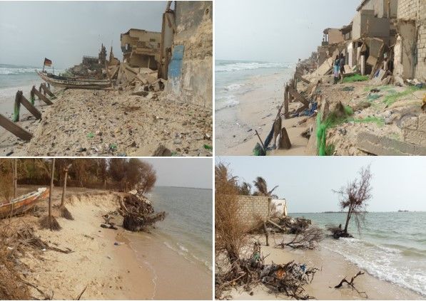
GSJ: Volume 9, Issue 1, January 2021
ISSN 2320-9186 231

The vulnerability of the estuary can also be explained by hydrological transformations
induced by water control infrastructures with serious morphological modifications in the
coastal area. Such facilities like dams are one of the major factors of sediment deficit of the
Langue de Barbarie sand sprit. It is important to point out that the Senegal River has a long
tradition of hydraulic infrastructures. As response to the recurrent series of drought during
seventies, a huge project of fresh water management had been put in place. Therefore, the
erection of two dams was essential to ensure the sustainability of water resource in the region.
For this purpose, the Diama and Manantali Dams have been respectively erected downstream
and upstream the Senegal River. The principal aim of the transnational dam of Diama was to
stop saline intrusion during the dry season and to stock enough volume of water for domestic
and irrigation purposes. This facility also created an artificial lake of 235 Km² with a capacity
of over 250 m³ millions destined to irrigate 120.000 ha of land and freshwater supply. This
changed hydrological regime of the Senegal River related to the dams of Diama (downstream)
and Manantali (upstream) has had strong impacts on the morphological evolution of the
region. They were indeed essential but did not take into account factors such as the
sedimentology and ecology of the estuarine environment.

The colonial city of Saint-Louis is also highly vulnerable to natural disaster. It has been
mentioned above the morphology of the city make it vulnerable to flooding and coastal
erosion. The phenomenon of flooding usually occurs during the raining season and especially
when the Diama dam is suddenly opened and delivers important discharge that creates a quick
rise of water level downstream. During the flood of 2003 the local authorities urgently
decided to create a runoff canal at 7km downstream Saint-Louis aimed at creating a closer
opening for the river discharge to reach the sea. The opening occurred during the night of 3 to
4 October 2003. This breach was about 4m wide; 100m long and 1,5m deep. However it
rapidly grew, widening from 4 to 600m already on the 6 of October (after 3 days) followed by
a higher sea tide than the average. Furthermore, when the rough sea hits, the southern part of
the canal is subjected to further erosion while the northern part accumulated little
sedimentation. This phenomenon keeps widening the canal constantly (K. Diagne et al,
2009).The marine hydrodynamic has been strongly affected by that artificial opening that
henceforth constitutes the Senegal River mouth. The amplification of the tidal range
throughout the estuary is the first obvious consequence of that created mouth. From daily
readings recorded downstream of Diama dam (i.e. 23 km north of the city) between January
2001 and January 2006, several studies (Dumas and Mietton, 2006; Mietton et al, 2006) have
highlighted that Semi-diurnal tide changes are occurring in several ways. On one hand, the
maximum daily tidal range has tripled, going from 0.30 m (2001-2002 average) to 0.93 m

 GSJ© 2021
 www.globalscientificjournal.com
GSJ: Volume 9, Issue 1, January 2021
ISSN 2320-9186 232

(2004-2005 average). On the other hand, tidal cycles are now more clearly felt all year round,
even during high winter waters.
In addition of being impacted by serious sediment deficit, the protective Langue de Barbarie
sand sprit is strongly affected by the artificial the mouth or breach.

Plate 2: Ongoing erosion in the locality of Guet-Ndar and the Lower estuary

Serious process of coastal erosion has been observed throughout the Langue de Barbarie sand
sprit. In the traditional fishermen villages of Guet Ndar, Ndar Toute and Goxxumbacc the
situation is just apocalyptic and desperate with huge socio economic damages including loss
of social amenities and even human causalities; in such areas, local dwellers are actually
living in perpetual fear of being uprooted by the sea. Towards the lower estuary, villages like
Pilote and Tassinere that were protected by the Langue de Barbarie sand sprit are actually
facing the new mouth and then exposed to such events like surges with disastrous
consequences on human settlements and touristic infrastructures. In addition to erosion the
lower estuary also known as “Gandiolais” generally housing farmers and breeders is facing
gradual salinization of water resources with serious environmental and socioeconomic
impacts.
Several adaptation strategies have been observed at the local scale. They are either
community based, put in place by local authorities or rather touristic investors.

 GSJ© 2021
 www.globalscientificjournal.com
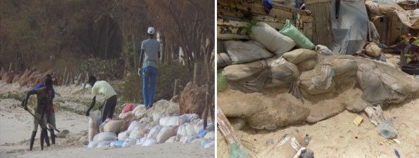
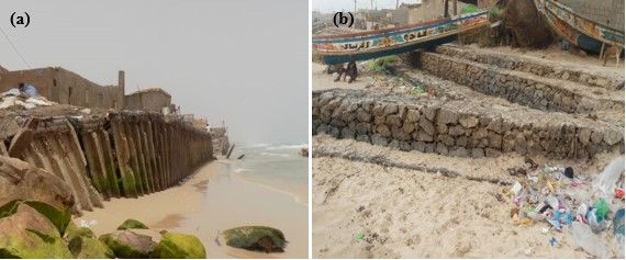
GSJ: Volume 9, Issue 1, January 2021
ISSN 2320-9186 233

Community based adaptation strategies are usually crude, temporary and not adapted to face
such events as storm surges. It mainly involves desperate attempts to contain the sea using
sand bags. This community adaptation measure has been observed throughout the coastline;
bags are usually filled with sand beach, superposed and aligned along houses as barrier
against the sea; in some cases dwellers are also using fishing nets to envelop the sand bags for
more resistance. According to them, when the sandbags are outlined together they will be
hardly uprooted. However, this technique of low expenditure is just for temporary defence,
sand Bags have short life expectancy due to lack of resistance to physical damage and UV
sunlight effects.

Plate 3: Community based adaptation strategies at Guet Ndar and Tassinere

Beside these communities based adaptation strategies, other structural infrastructures
involving huge engineering were also observed along the shore. These protective measures
are mainly represented by the sea wall of Ndar Toute erected by colonial masters in 1962 and
the recent dyke of Goxxumbacc built in 2019 by local authorities. However, the seawall of
Ndar toute is nowadays old, in state of deterioration and is longer playing its protective role,
while the new dyke of Goxxumbacc is just covering 1.6km over 3.5km.

Plate 4: (a) Sea Wall of Ndar Toute (1962), (b) Dyke of Goxxumbacc (2019)

 GSJ© 2021
 www.globalscientificjournal.com
GSJ: Volume 9, Issue 1, January 2021
ISSN 2320-9186 234

In addition to these 2 facilities, it has been noted that in the lower estuary, touristic investors
are mobilizing their effort to protect their amenities (guest houses, camps) against the sea
mainly using ripraps, concrete walls and also tetrapods.

Plate 5: ripraps and tetrapods immerged to protect a tourist camp at Gandiol

Besides these structural facilities of shoreline protection, nature based adaptation strategies
are also experimented in the estuary. Among these non structural methods, reforestation of
Casuarina equisetifolia tree locally named Filao is mostly applied along the Sand sprit. That
program of dunes stabilization has been initiated since 1981 and is still encouraged by the
local authorities.

Plate 6: Plantation of filaos along the Langue de Barbarie Sand Sprit

Relocation is also an adopted measure by local authorities. Many families from the fishermen
communities of GuetNdar and Goxxumbacc, victims of sea level rise have been relocated in

 GSJ© 2021
 www.globalscientificjournal.com
GSJ: Volume 9, Issue 1, January 2021
ISSN 2320-9186 235

land. Nowadays, the sites of “Khar yAllah” and “Boudiouck” are actually housing more than
150 displaced families in difficult conditions including poor sanitation and restricted access to
water and electricity. In the refugee camp of Boudiouck it has been observed that victims are
installed in 336 provisional habitation facilities that hardly respect human dignity; water is
sold to them and they hardly access to power (electrification). Moreover, these refugees also
called ‘the forgotten” confessed that they are suffering from excessive heat and insecurity in
these provisional habitations tents while being exposed to snakes and scorpions as well as
storms during the raining season. Finally, this relocation raised the issue of identity because
according to them it has been difficult to be displaced leaving behind their native habitat as
well as their traditional activities and unique sources of livelihood.

Plate 7: Relocation camp of Boudiouck

Conclusion
The present paper raised the complexity of the coastal vulnerability study of the Senegal
River estuary. It revealed that the vulnerability of Saint-Louis is both related to the
combination of natural and anthropogenic factors. In addition of being a fragile environment
characterized by its flatness with gentle slope and aggressive marine hydrodynamic, the
estuary has been deeply affected by human intervention mainly through population growth,
anarchic occupation and resilient infrastructures. The applied Coastal Vulnerability Index
showed that more than 70% of the coastline is at high vulnerability mostly felt in the populous
fishermen villages of Guet-Ndar, Ndar Toute, Goxxumbacc and around the new artificial
mouth. The situation in these areas is at limit desperate even if some adaptation strategies
have been put in place. Adaption is the biggest challenge faced by these coastal communities
considering the level of poverty prevailing there where the majority is usually of low income.
The community based adaptation strategies are obviously not adapted to face the strength of
the sea; some facilities as the sea wall of NdarToute are actually old and dated since colonial

 GSJ© 2021
 www.globalscientificjournal.com
GSJ: Volume 9, Issue 1, January 2021
ISSN 2320-9186 236

masters while reaction of local authorities is taking place at lower pace even if some efforts
have been recently felt. It is also important to point out the fact that these efforts came a bit
late and don’t cover and protect the entire dedicated area. Finally, relocation of impacted
coastal communities is not an easy task; it should be well planned with adapted and decent
welcoming infrastructures supported by gradual accompanying measures.

References
Barbey C. (1967)., Le littoral de Dakar à Saint-Louis à la lumière de documents anciens.
 Notes Africaines, IFAN, n°116, p. 122 - 124.

Beck, U., 2001, La société du risque. Sur la voie d’une autre modernité, Paris, Aubier,
 Première édition : 1986, 521 p

D'ercole R (1994a).La catastrophe t son impact a moyen terme : l‘exemple de Popayan
 (Colombie) dix ans après le séisme du 3l mars 1983 - Résumés du colloque
 "croissance urbaine et risques naturels principalement dans les pays en voie de
 développement 2, et 3 décembre 1994, Université Blaise Pascal Clermont-Ferrand,
 PP.55-57.

D'ercole R (1994b). Les vulnérabilités des sociétés et des espaces urbanisés: concepts,
 typologie, modes d'analyse - Revue de Géographie Alpine, No4, Tome II pp.87-96.

Dia Aliou Mamadou (2000). Ecoulements et inondations dans l'estuaire du fleuve Sénégal
 : Le cas de la ville côtière de Saint-Louis. Dakar (SEN) ; Dakar : UCAD ; IRD, 64 p.
 multigr.Mém.DEA:Géogr.,http://horizon.documentation.ird.fr/exldoc/pleins_textes/ple
 ins_textes_7/b_fdi_57-58/010024683.pdf

Diagne, Khady. (2007). Governance and natural disasters: Addressing flooding in Saint
Louis,
 Senegal. Environment and Urbanization - ENVIRON URBAN. 19. 552-562.
 10.1177/0956247807082836.https://www.slurc.org/uploads/1/6/9/1/16915440/e_u_19.
 2_diagne_saint_louis.pdf

Direction de l’Environnement et des Etablissements Classés du Sénégal, Centre de suivie
 écologique (2005). Rapport sur l’Etat de l’environnement au Sénégal. Première
 édition, Ministère de l’Environnement et de la Protection de la Nature.53-82

Dumas D., Mietton M., 2006, « Fonctionnement des hydrosystèmes et gestion de l’eau dans le
 bas delta du fleuve Sénégal : ruptures et adaptations », Actes du Colloque international
 « Interactions nature et sociétés, analyses et modèles », La Baule, 5 p.

Guilcher A., Nicolas J.P. (1954).Observations sur la langue de Barbarie et les environs
 du Sénégal aux environs de Saint-Louis. Bulletin d'information du comité central
 d'océanographie et d'étude des côtes, vol. VI, n°1, p. 227 - 242.

Fabiani, J.-L. Et J. Theys, (1987). La société vulnérable. Évaluer et maîtriser les risques,
 Paris, Presses de l’Ecole Normale Supérieure, 674 p.

 GSJ© 2021
 www.globalscientificjournal.com
GSJ: Volume 9, Issue 1, January 2021
ISSN 2320-9186 237

Gornitz, V., (1991). Vulnerability of the US to future sea level rise. CONF-910780—1,
 DE91 007853, pp.17.https://www.osti.gov/servlets/purl/5875484

Gornitz, V. M.,Daniels, R.C., White, T. W., and Birdwell, K. R., (1994). The development of
 a coastal risk assessment database: Vulnerability to sea-level rise in the U.S. southeast.
 Journal of Coastal Research, Special Issue No. 12, p. 327-338.

Gornitz , V., Rosenzweig, C. & Hillel, D (1994).. Is sea level rising or falling
 ?. Nature 371, 481. https://doi.org/10.1038/371481a0

Hapke C.J., Reid D., Richmond B.M., Ruggiero P., List J. (2006). National Assessment of
 Shoreline Change Part 3: Historical Shoreline Change and Associated coastal land loss
 Along Sandy Shorelines of the California Coast .USGS Report13-14.
 https://pubs.usgs.gov/of/2006/1219/of2006-1219.pdf

Kane. A., (1997). L’après-barrage dans la vallée du fleuve Sénégal : modifications
 hydrologiques, morphologiques, géochimiques, sédimentologiques. Conséquences sur
 le milieu et les aménagements hydro-agricoles. Thèse de doctorat d’Etat, Dakar,
 UCAD, 551 pages.

Kane.C, 2010. Vulnérabilité du système socio-environnemental en domaine sahélien :
 l’exemple de l’estuaire du fleuve Sénégal ». Thèse de doctorat, cotutelle UCAD/
 Université Strasbourg, 318 pages.
 https://publicationtheses.unistra.fr/public/theses_doctorat/2010/KANE_Coura_2010.p
 df

Masseye Seye (2005). Zones humides artificielles et agriculture périurbaine. L’utilisation
 des eaux usées de la station de Saint-Louis pour le maraîchage dans la communauté
 rurale de Gandon. Mémoire de DEA (Gestion intégrée et développement durable des
 régions côtières et des petites îles), Chaire UNESCO/UCAD, Département de
 géographie, Faculté des Lettres et Sciences Humaines (FLSH), Université Cheikh
 Anta Diop, 53 p.+ annexes.

Mietton M., Dumas D., Hamerlynck O., Kane A., Coly A., Duvail S., Baba M.L.O., Daddah
 M., 2006, « Le delta du fleuve Sénégal. Une gestion de l’eau dans l’incertitude
 chronique », Actes du Colloque international « Incertitudes et Environnement-
 mesures, modèles, gestion », Arles, France, 23-25 novembre 2005, 12 p.
 https://www.researchgate.net/publication/32223606_Le_delta_du_fleuve_Senegal_Un
 e_gestion_de_l'eau_dans_l'incertitude_chronique/link/0912f51125285622ad000000/d
 ownload

Nicolas J P., (1953). Note sur l’importance relative des divers facteurs agissant sur la
 morphologie de la Langue de Barbarie, Saint-Louis du Sénégal, 10p.

SALL Mohamadou, Dr. Serigne Mansour Tall, Dr. Aly Tandiang, Al Assane Samb, (2011).
 Changements climatiques, stratégies d’adaptation et mobilités. Evidence à partir de
 quatre sites au Sénégal; Novembre 2011, 49 pages.
 https://pubs.iied.org/pdfs/10612IIED.pdf

Thieler, E.R. and Hammar-Klose, E.S. (1999) National Assessment of Coastal Vulnerability
 to Sea-Level Rise, U.S. Atlantic Coast. US Geological Survey, Open-File Report, 99-
 593. https://pubs.usgs.gov/of/1999/of99-593

 GSJ© 2021
 www.globalscientificjournal.com
GSJ: Volume 9, Issue 1, January 2021
ISSN 2320-9186 238

Woppelmann, Guy & Martin Miguez, Belen & Créach, Ronan. (2008). Tide gauge records at
 Dakar, Senegal (Africa): towards a 100-years consistent sea-level time series?. 10530.
 https://www.researchgate.net/publication/317318654_Tide_gauge_records_at_Dakar_
 Senegal_Africa_towards_a_100years_consistent_sealevel_time_series/link/5931cbafa
 6fdcc89e7a86b74/download
World Bank (2013).Economic and spatial Study of the Vulnerability and Adaptation to
 Climate Change of Coastal areas in Senegal. 123pg.
 http://documents1.worldbank.org/curated/en/537811468305337766/pdf/837830WP0P
 12030Box0382112B00PUBLIC0.pdf

 GSJ© 2021
 www.globalscientificjournal.com
You can also read