PRE - SURVEY FISHERY ASSESSMENT AT BARRYROE (SEL 1/11), NORTH CELTIC SEA, SOUTH WEST COAST OF IRELAND
←
→
Page content transcription
If your browser does not render page correctly, please read the page content below
PRE- SURVEY FISHERY ASSESSMENT

  AT BARRYROE (SEL 1/11), NORTH CELTIC
   SEA, SOUTH WEST COAST OF IRELAND

                                           FOR

                                  EXOLA DAC

Prepared by:

Eimear Stafford
________________________
Sinbad Offshore Support Limited
Church Road, Killybegs
Co. Donegal

Dated: 13th January 2020
Client Document Reference: BAR‐PGE‐K101

                                  Pre‐Survey Fishery Assessment
                                                                  Page No: 1
                                     Doc. Ref. BAR‐PGE‐K101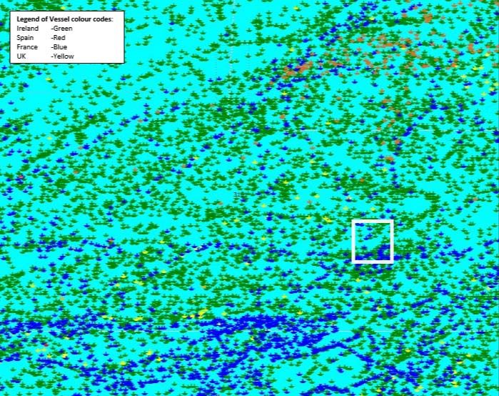
List of Abbreviations

ANIFPO          ‐       Anglo‐North Irish Fish Producers Organisation
DCCAE           ‐       Dept of Communications, Climate action & Environment
BIM             ‐       Bord Iascaigh Mhara
EIS             ‐       Environmental Impact Statement
EEZ             ‐       Exclusive Economic Zone
FEL             ‐       Frontier Exploration Licence
FLO             ‐       Fisheries Liaison Officer
FMC             ‐       Fisheries monitoring centre
FPO             ‐       Fish Producers Organisation
ICES            ‐       International Council for Exploration of the Seas
IFPO            ‐       Irish Fish Producers Organisation
IRCG            ‐       Irish Coast Guard
IS&EFPO         ‐       Irish South & East Fish Producers Organisation
IS&WFPO         ‐       Irish South & West Fish Producers Organisation
IOSEA           ‐       Irish Offshore Strategic Environmental Assessment
KFO             ‐       Killybegs Fishermen’s Organisation
MI              ‐       Marine Institute
MSO             ‐       Marine Survey Office
NEAFC           ‐       North East Atlantic Fisheries Commission
NIFA            ‐       National Inshore Fisheries Association
NIFF            ‐       National Inshore Fisheries Forum
NIFO            ‐       National Inshore Fisheries Organisation
PAD             ‐       Petroleum Affairs Division
RIFF            ‐       Regional Inshore Fisheries Forum
RSW             ‐       Refrigerated Sea water or Refrigerated Salt water
SAC             ‐       Special Area of Conservation
SFPA            ‐       Sea Fisheries Protection Authority
VHF             ‐       Very High Frequency (Radio)
VMS             ‐       Vessel Monitoring System

DISCLAIMER

This report has been prepared by Sinbad Offshore Support Ltd on behalf of Exola DAC., a wholly owned
subsidiary of Providence Resources P.L.C. and contains general information about fishery activities in
the waters offshore Ireland. While due care has been used in the preparation of information, Sinbad
Offshore Support Ltd has no legal responsibility for the content of the information so provided
(including, without limitation, as to the quality, accuracy, completeness or fitness for any particular
purpose of such information). No guarantee, representation or warranty whatsoever is given, express
or implied, relating to any of the content of this report. Sinbad Offshore Support Ltd does not accept
any liability for error or omission or for any loss or damage caused, arising directly or indirectly, in
connection with reliance on the use of such information.

                                       Pre‐Survey Fishery Assessment
                                                                                           Page No: 2
                                          Doc. Ref. BAR‐PGE‐K101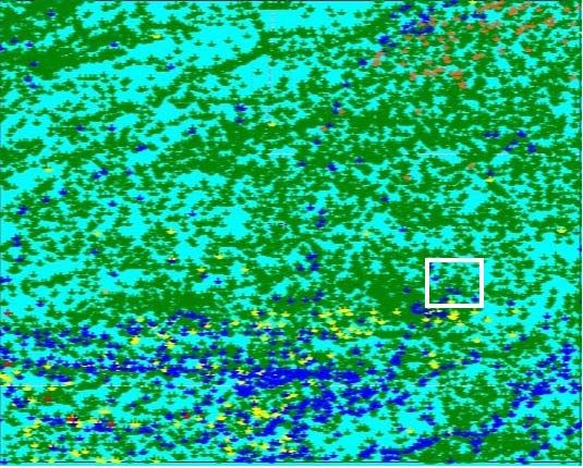
Contents
1.     Executive Summary ......................................................................................................................... 7

2.     Introduction .................................................................................................................................... 8

     2.1.     General introduction of proposed Barryroe K site survey ...................................................... 8

     2.2.     Survey Location and Baseline Environment.......................................................................... 10

     2.3.     Spawning areas of some key species .................................................................................... 13

3.     Fisheries ........................................................................................................................................ 15

     3.1.     Fisheries Management.......................................................................................................... 15

     3.2.     Commercial Fisheries Overview and catch statistics for 2018 ............................................. 17

       3.2.1.         Demersal Fisheries ........................................................................................................ 18

       3.2.2.         Demersal Catch statistics for 2018 and landings data 2019 ......................................... 21

       3.2.3.         Pelagic Fisheries ............................................................................................................ 22

       3.2.4.         Pelagic catch statistics for 2018 and landings data 2019 ............................................. 24

       3.2.5.         Shellfish commercial fishery and landings data 2019 ................................................... 25

     3.3.     Fishing Methods in survey area ............................................................................................ 27

       3.3.1.         Bottom (Otter) Trawling / Seining ................................................................................ 28

       3.3.2.         Gillnetters...................................................................................................................... 28

       3.3.3.         Mid‐water Trawling ....................................................................................................... 28

     3.4.     Irish discharge Ports .............................................................................................................. 29

       3.4.1.         Castletownbere Fishery Harbour Centre (FHC) ............................................................ 30

       3.4.2.         Union Hall Fishery Harbour Centre ............................................................................... 30

       3.4.3.         Dunmore East Fishery Harbour Centre ......................................................................... 30

       3.4.4.         Other ports .................................................................................................................... 30

4.     Stakeholder Analysis ..................................................................................................................... 32

     4.1.     Fisheries Notification ............................................................................................................ 32
                                                          Pre‐Survey Fishery Assessment
                                                                                                                                         Page No: 3
                                                             Doc. Ref. BAR‐PGE‐K101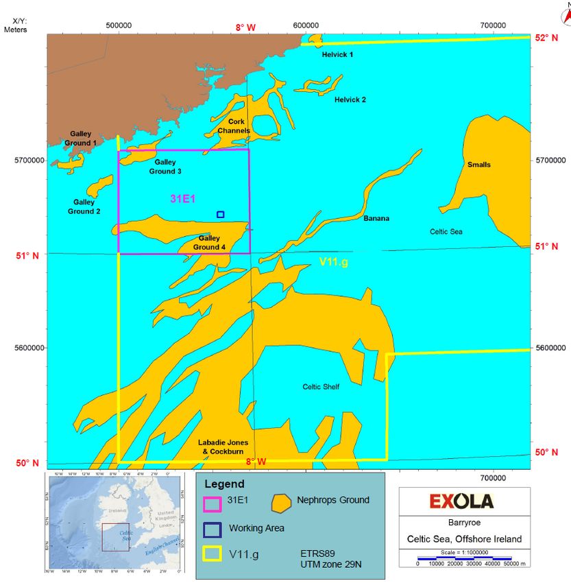
4.2.     Fishing organisations contacted ‐ Fish Producer Organisations (FPO) ................................. 32

     4.3.     Communication strategy ....................................................................................................... 33

     4.4.     Commercial Traffic / Navigation ........................................................................................... 33

5.     Analysis of fisheries data............................................................................................................... 36

     5.1.     Summary of VMS data for 2017, 2018 and 2019 .................................................................. 36

     5.2.     Summary of fisheries interaction / potential impacts .......................................................... 41

       5.2.1.         Nephrops Fishery: ......................................................................................................... 41

       5.2.2.         Crab fishery: .................................................................................................................. 41

       5.2.3.         Scallop fishery: .............................................................................................................. 41

       5.2.4.         Demersal Whitefish:...................................................................................................... 42

       5.2.5.         Pelagic fishery: .............................................................................................................. 42

6.     Recommendations ........................................................................................................................ 43

7.     Conclusion ..................................................................................................................................... 44

                                                         Pre‐Survey Fishery Assessment
                                                                                                                                        Page No: 4
                                                            Doc. Ref. BAR‐PGE‐K101
FIGURES
Figure 2.1 Proposed Barryroe K Site Survey Activities. ........................................................................... 9
Figure 2.2 Proposed Barryroe K site survey operation areas. .............................................................. 11
Figure 2.3 Biologically Sensitive Area shown in pink shading, with site survey location represented by
a blue star. ............................................................................................................................................ 12
Figure 3.1 The boundaries of the ICES subdivisions within Ireland’s EEZ (SFPA). Area VIIg extends
southwards over the UK boundary. Barryroe K site survey shown as a blue star. ............................... 16
Figure 3.2 The spatial distribution of landings for the main benthic, gadoid and shellfish species
around Ireland (ICES Fisheries Overview). ............................................................................................ 20
Figure 3.3 Demersal landings to Irish ports in 2018 (SFPA). ................................................................. 21
Figure 3.4 Pelagic fish landings to Irish ports in 2018 (SFPA). .............................................................. 24
Figure 3.5 Spatial extent of primary Nephrops fishing grounds in Irish waters. Individual grounds are
coloured by relevant Functional Units (FUs) (Marine Institute). Barryroe is shown as a blue star...... 26
Figure 3.6 Location of statistical rectangle 31E1 relative to Cork channels and Galley nephrops
grounds. ................................................................................................................................................ 27
Figure 3.7 The main Irish Fisheries Ports. ............................................................................................. 29
Figure 3.8 Landings by weight in Irish ports ‐ 2018 .............................................................................. 31
Figure 4.1 Shipping density in 2017 – EU‐ATLAS ‐ EMODnet................................................................ 34
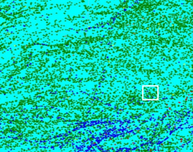
Figure 5.1 VMS data of individual fishing vessel numbers recorded by flag in 31E1. .......................... 37
Figure 5.2 VMS screenshot of 31E1 from Apr‐Sep 2017 with proposed survey area outlined in white.
.............................................................................................................................................................. 38
Figure 5.3 VMS screenshot of 31E1 from Apr‐Sep 2018 with proposed survey area outlined in white.
.............................................................................................................................................................. 39
Figure 5.4 VMS screenshot of 31E1 from Apr‐Sep 2019 with proposed survey area outlined in white.
.............................................................................................................................................................. 40
Pre‐Survey Fishery Assessment
Page No: 5
Doc. Ref. BAR‐PGE‐K101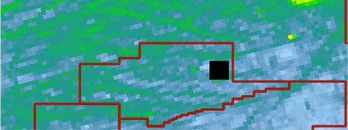
TABLES
Table 2.1 Coordinates of operation working areas. ............................................................................. 10

Table 2.2 Fish Spawning and Nursery areas in the vicinity of the proposed Survey Area (ICES
Rectangle 31E1) (Coull et al., 1998; Marine Institute,2009; Ellis et al.,2012) ...................................... 14

Table 3.1 Commercial demersal fisheries – target fishery species, seasonality, target depths, fishing
methods employed by the national and international fleets. .............................................................. 19

Table 3.2 Demersal landings from Statrect 31E1, Apr‐Sep 2019 (SFPA). ............................................. 22

Table 3.3 Commercial pelagic fisheries ‐ target fishery species, seasonality, target depths, fishing
methods employed by the national and international fleets. .............................................................. 24

Table 3.4 Shellfish landings from Statrect 31E1 for the period Apr‐Sep 2019 (SFPA) .......................... 26

Table 4.1 Cork shipping schedules and routes...................................................................................... 35

Table 5.1 VMS data of individual fishing vessel numbers recorded by flag in 31E1............................. 36

Table 5.2 Coordinates for ICES statistical rectangle 31E1. ................................................................... 37

                                                  Pre‐Survey Fishery Assessment
                                                                                                                     Page No: 6
                                                     Doc. Ref. BAR‐PGE‐K101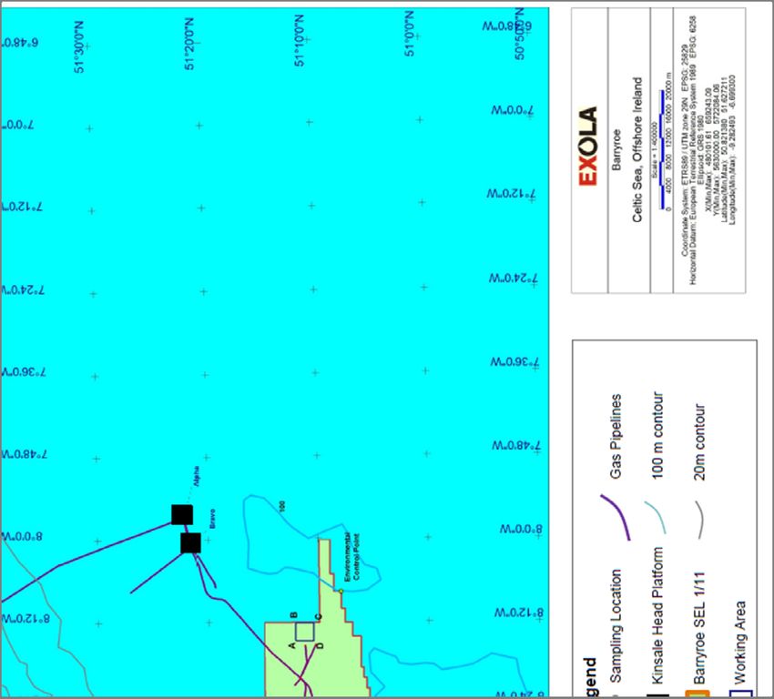
1. Executive Summary

Exola DAC, a wholly owned subsidiary of Providence Resources P.l.c. (hereafter referred to as “Exola”),
is proposing to conduct site survey activities within the Barryroe licence area (SEL 1/11) situated in
the North Celtic Sea Basin. Details of the planned survey at the ‘Barryroe K site’ (Figure 2) are outlined
in the introduction overleaf.

Details of the survey contractor and survey vessel will be furnished to marine stakeholders in advance
of the commencement of the survey activities. The proposed equipment to be deployed will include
Multi beam Echo Sounder (MBES), Single beam Echo Sounder (SBES), Side Scan Sonar (SSS), Ultra‐
short Baseline Positioning (USBL), Magnetometer, environmental sampling & habitat assessment
photography. There will also be a hull‐mounted Sub‐Bottom Profiler (SBP).

This assessment outlines the anticipated fishing activity in the Celtic Sea Basin studied in the IOSEA 5
environmental assessment ‐ https://www.dccae.gov.ie/en‐ie/natural‐resources/Pages/default.aspx
and possible scope of overlap with the planned site survey in ICES area VIIg (see Figure 3.1), fishery
statistical rectangle 31E1 (Figure 3.6) which encompasses the site survey location.

A factsheet with survey details and location map was emailed to the key Irish fishery organisations in
early December 2019 in keeping with best practice of early notification to marine stakeholders.
Communication with fisheries is open and will remain open until the survey is complete. The Irish Sea
Fishery Protection Authority (SFPA) has also been consulted.

The Fisheries Management Centre (FMC) at the Irish Naval Base provided some Vessel Monitoring
System (VMS) data from the SEL 1/11 area for a six‐month period over three years from 2017 to
2019 and this assessment examines these results. Vessels >12m overall length (LOA) are required to
be fitted with a VMS and the data analysed shows fishery effort in the 31E1 fishery statistical
rectangle which encompasses Barryroe and the proposed survey area. Analysis of the VMS data is
detailed in Section 5 of this assessment. As vessels
2. Introduction

2.1.     General introduction of proposed Barryroe K site survey

Exola DAC, a wholly owned subsidiary of Providence Resources P.l.c. (hereafter referred to as “Exola”),
is proposing to conduct site survey activities within the Barryroe licence area (SEL 1/11); situated in
the North Celtic Basin approximately 43 kilometres (km) south east of the closest coastline at
Ballymacshoneen, Butlerstown North, County Cork on the south coast of Ireland.

The site survey activities will comprise a seabed and shallow geophysical survey and an environmental
baseline and habitat assessment survey to be conducted over a singles potential well location at
Barryroe, as illustrated in Figure 2.1, together with a single environmental control point located
approximately 10 km to the east‐southeast. The survey covers a total area of approximately 9 km2
around which a 1 km buffer zone will allow for the survey vessel manoeuvres during equipment
deployment and recovery, and line turns.

The survey vessel is anticipated to be working on location for up to 3 days, excluding transit, port calls
and weather downtime. Operations are proposed to take place at some point between the 1st April
2020 and 30th November 2020, subject to regulatory approval and vessel availability. If the survey has
not commenced within this timeframe, the operations will be undertaken sometime between 1st
February 2021 and 30th November 2021, again subject to regulatory approval and vessel availability.

This assessment has concentrated on the period April to September as this represents the period
where interactions between the site survey activities and fisheries would be greatest. An on‐board
Fisheries Liaison Officer (FLO) will ensure good that communication with fishing vessels in the area will
be maintained, particularly regarding planned survey vessel movements during survey operations.

                                        Pre‐Survey Fishery Assessment
                                                                                             Page No: 8
                                           Doc. Ref. BAR‐PGE‐K101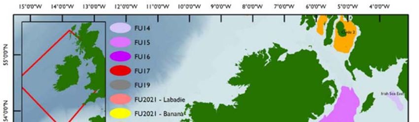
Figure 2.1 Proposed Barryroe K Site Survey Activities.

              Pre‐Survey Fishery Assessment
                                                         Page No: 9
                 Doc. Ref. BAR‐PGE‐K101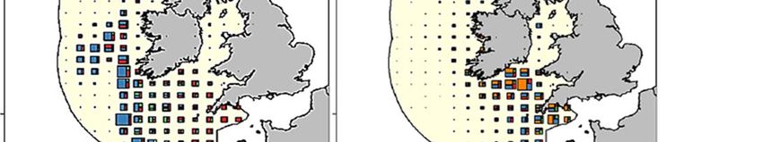
2.2.     Survey Location and Baseline Environment

The proposed Barryroe K site survey activities will be conducted over one potential well location,
within one square survey vessel activity area, as shown in Figure 2.2. Outside of the survey vessel
activity areas, additional environmental sampling is expected to be conducted at one control location,
located approximately 10 km to the east‐southeast, also shown on Figure 2.2. The proposed survey
and greater working areas are defined by the coordinates outlined in Table 2.1.

                                         ETRS1989 (WGS84)
          Survey Corner                         Latitude                          Longitude
                                             Survey Area
                A                   51° 12' 6.0426" N                  8° 14' 41.919" W
                B                   51° 12' 5.0169" N                  8° 12' 7.3511" W
                C                   51° 10' 27.9114" N                 8° 12' 9.0276" W
                D                   51° 10' 28.9361" N                 8° 14' 43.5053"W
       Buffer Corner Point                      Latitude                          Longitude
                                       Greater Working Area
                 E                  51° 12' 38.7409" N                 8° 15' 32.9255" W
                 F                  51° 12' 37.0309" N                 8° 11' 15.2599" W
                 G                  51° 9' 55.1874" N                  8° 11' 18.1042" W
                 H                  51° 9' 56.8947" N                  8° 15' 35.5192" W
                                    Environmental Control Point
                                    51° 7' 57.4" N                     8° 7' 38.217"W

                          Table 2.1 Coordinates of operation working areas.

The Barryroe licence area is located in the North Celtic Sea Basin, at approximately 43 km offshore off
the coast of southern Ireland and is adjacent to the PETRONAS operated Seven Heads and Kinsale
Head gas fields. The North Celtic Sea Basin is bordered by Saint George’s Channel to the northeast,
by the Bristol Channel to the east, the Bay of Biscay to the south, opening to the Atlantic Ocean to the
west and southwest.

The Celtic Sea south of Ireland is an extended shelf within which the water depth is generally less than
100 m. The northeast portion has depths of between 90 m and 100 m, increasing towards Saint
George's Channel. In the opposite direction, sand ridges pointing southwest have a similar height,
separated by troughs approximately 50 m deeper.

The seabed of the Celtic Sea region is primarily comprised of extensive areas of mixed sediments,
coarse, rocky, and sandy to muddy sands. Areas of rock and hard substratum are present in the inshore
parts of the region.

Generally, water movement is from south to north, with oceanic water from the North Atlantic
entering from the south and west of the region. The strongest winds in this area come from the west
and south, with a tendency for the strongest winds to be experienced in the west of the region.

                                       Pre‐Survey Fishery Assessment
                                                                                           Page No: 10
                                          Doc. Ref. BAR‐PGE‐K101
Figure 2.2 Proposed Barryroe K site survey operation areas.
Pre‐Survey Fishery Assessment
Page No: 11
Doc. Ref. BAR‐PGE‐K101Licence SEL 1/11 is located within ICES sub‐division VIIg (as illustrated at Figure 2.3) and statistical
rectangle 31E1 (as illustrated at Figure 3.6). The area is influenced by the Gulf Stream resulting in rich
and diverse fishing grounds. 31E1 is the location of the Kinsale Galley Head fishing grounds.
Ballycotton fishing grounds lie to the north of the survey area. Labadie, Jones, Pistola, Nymphe,
Northwest and West banks lie to the south and southwest of 31E1 and are very popular areas for
demersal fisheries.
The Barryroe K site survey area lies approximately 30 km northwest of the UK boundary.
The importance of southern and southwestern Irish waters as spawning and nursery grounds for
stocks such as Herring, Mackerel and Hake and other demersal species is recognised by the
establishment of a Biologically Sensitive Area (BSA) by the EU Commission. This area is shown on the
map below (Figure 2.3). 31E1 is located within the boundary of the EU‐Commission designated
Biologically Sensitive Area.
In 2003, the EU also established a specific fishing effort regime inside the BSA and outside the BSA for
demersal, scallop and crab fisheries (i.e. different fishing effort regulations apply inside and outside of
the box) (Council Regulation (EC) No 1954/2003).
The BSA overlaps with spawning and nursery areas for several important demersal stocks and pelagic
stocks, examples of which are given below in Table 2.2.
Figure 2.3 Biologically Sensitive Area shown in pink shading, with site survey location represented by
a blue star.
Pre‐Survey Fishery Assessment
Page No: 12
Doc. Ref. BAR‐PGE‐K1012.3. Spawning areas of some key species
There are spawning, and nursery areas of commercially important species present within the BSA.
Many fish species aggregate to spawn. Some species may aggregate behaviourally and so may have
extensive spawning grounds that may change location slightly from year to year, while other species
may aggregate over a more restricted spatial extent. (Coull et al, 1998). There are numerous modes
of reproduction in fishes, and broadcast spawning, which involves shedding the eggs and sperm into
the water column, is one of the more frequent strategies (Balon, 1984) and such species may have
more extensive spawning grounds than those species which deposit eggs on the sea floor.
Juvenile fish are vulnerable to predators and harsh conditions in the open water. Therefore, it is
typical for juvenile fish to stay in sheltered nursery grounds which provide an abundance of food. At
nursery and spawning grounds, fish aggregate in large numbers and so are particularly vulnerable to
disturbance.
The proposed Barryroe K site survey area overlaps known spawning grounds and nursery areas for
certain fish species. Pelagic spawning species in the area include Mackerel, Horse Mackerel, Blue
Whiting and Herring, while demersal spawning species in the area include Nephrops, Cod, Hake,
Megrim, Whiting and Haddock.
Table 2.2 shown below includes information from CEFAS, the Centre for Environment, Fisheries and
Aquaculture Science and shows a sample of both pelagic and demersal species spawning periods off
the south coast of Ireland. It is worthwhile noting that fish spawning can vary temporally and spatially,
such that spawning areas are diverse, and fish may spawn earlier or later in the season.
Pre‐Survey Fishery Assessment
Page No: 13
Doc. Ref. BAR‐PGE‐K101Species J F M A M J J A S O N D
Anglerfish¹
Lophius N N N N N N N
piscatorius
Blue whiting
Micromesistius N N N
poutassou
Cod
Gadus morhua
Common skate 2
Dipturus batis‐ N N N N N N N N N N N N
complex
European hake
Merluccius N N N N N
merluccius
Haddock
Melanogrammus N N N N
aeglefinus
Horse mackerel
Trachurus N N N N
trachurus
Lemon Sole
N N N N N N
Microstomus kitt
Ling
N N N N
Molva molva
Mackerel
Scomber N N N N N
scombrus
Megrim
Lepidorhombus N N N N
whiffiagonis
Nephrops N N N N N N N N N N N N
Sprat
Sprattus sprattus
Spurdog 3
Squalus N N N N N N N N N N N N
acanthias
Whiting
Merlangius N N N N N
merlangus
Key:
Indicates the
Without
Peak Low Intensity period when
Spawning N Nursery
Spawning Spawning survey may
Period
occur 4
Table 2.2 Fish Spawning and Nursery areas in the vicinity of the proposed Survey Area (ICES
Rectangle 31E1) (Coull et al., 1998; Marine Institute,2009; Ellis et al.,2012)
Pre‐Survey Fishery Assessment
Page No: 14
Doc. Ref. BAR‐PGE‐K1013. Fisheries
3.1. Fisheries Management
Within EU waters, fisheries management is conducted in accordance with the EU Common Fisheries
Policy (CFP), and catching opportunities for stocks under EU competency are agreed during meetings
of the Council of Ministers. Under the CFP’s regionalization policy, proposals on certain issues (for
example discard plans) are made by the North Western Waters Regional Fisheries Group. National
authorities manage activities in coastal waters (i.e. within 12 nautical miles). The fisheries for some
stocks are managed based on agreements by the North East Atlantic Fisheries Commission (NEAFC)
and by coastal states. Salmon fisheries are managed nationally based on agreements at the North
Atlantic Salmon Conservation Organization (NASCO), and fisheries for large pelagic fish are managed
based on agreements at the International Commission for the Conservation of Atlantic Tunas (ICCAT).
International fisheries advice is provided by the International Council for the Exploration of the Sea
(ICES), the European Commission’s Scientific Technical and Economic Committee for Fisheries (STECF),
the Standing Scientific Committee of ICCAT, and the North Western Waters and Pelagic Advisory
Councils.
The ICES designated Celtic Seas ecoregion includes all or parts of the Exclusive Economic Zones
(EEZs) of three current EU Member States (Irelands, UK, and France) and of the Isle of Man. The
ecoregion ranges from north of Shetland to Brittany in the south and includes subdivision VIIg.
Total allowable catch (TAC) is the main fishery management tool in the ICES designated Celtic Seas
ecoregion. These TACs were introduced for most stocks in 1982, but the TACs (and quotas) were
generally not restrictive until the early 1990s. The 2013 reform of the Common Fisheries Policy aimed
to eliminate discarding through the introduction of the EU landing obligation (LO). The LO was
introduced for pelagic species in 2015 and has been phased in for demersal TAC species since 2016.
From 2019, the LO applies to all TAC species, although there are some exemptions.
TACs are supplemented by a large number of technical measures which act as a fisheries management
tool. For example, these include measures to improve the selectivity of towed gears (partly in order
to reduce bycatch), and effort and gear restrictions. The EU Commission govern both common and
regional technical measures.
Spatial management is also employed, both for fisheries and for ecosystem reasons. For example,
closed areas/seasons are used to protect spawning grounds for fish. Protected areas have also been
designated for habitats and species listed by EU Nature Directives. Fishery regulations are in place to
restrict certain fisheries that may affect relevant habitats and species, e.g. for cold‐water corals.
The waters of the Northeast Atlantic are divided by ICES into a series of divisions and sub‐divisions
(Figure 3.1), which are used to geo‐reference the boundaries of fish stock and fisheries management
areas and to coordinate scientific oceanographic and marine resource research. The planned Barryroe
K site survey activities are proposed to take place within ICES statistical rectangle 31E1 in sub‐division
VIIg (see Figure 3.6).
The waters around Ireland consist of ICES Sub‐areas VI and VII which contain Divisions VIa, b and
VIIa ‐ k. The divisions are further partitioned into statistical rectangles of 0.5X latitude by 1.0X
longitude, or 70 km by 55 km (3,880 km2). The Irish Exclusive Economic Zone (EEZ) is the sea area in
Pre‐Survey Fishery Assessment
Page No: 15
Doc. Ref. BAR‐PGE‐K101which Ireland has special rights over the use of marine resources. It extends up to 200 nm offshore
(Figure 3.1).
Figure 3.1 The boundaries of the ICES subdivisions within Ireland’s EEZ (SFPA). Area VIIg extends
southwards over the UK boundary. Barryroe K site survey shown as a blue star.
ICES is a network of more than 4000 scientists from over 350 marine institutes in 20‐member countries
and beyond. 1600 scientists participate in their activities annually.
ICES is committed to building a foundation of science around one key challenge: integrated ecosystem
understanding of marine ecosystems. ICES advances this through the coordination of oceanic and
coastal monitoring and research and advises international commissions and governments on marine
policy and management issues. They provide the best available science for decision‐makers to make
informed choices on the sustainable use of the marine environment and ecosystems when deciding
quota controls.
The Irish Naval Service acts as the official agency with responsibility for the operation of Ireland’s
Fisheries Monitoring Centre (FMC). This responsibility is carried out as part of a Service Level
Agreement between the Department of Defence, Naval Service and the Sea Fisheries Protection
Authority (SFPA). The FMC is located at Naval Base, Haulbowline, Cobh, Co. Cork.
Pre‐Survey Fishery Assessment
Page No: 16
Doc. Ref. BAR‐PGE‐K101The FMC carries out monitoring and surveillance of all fishing vessels equipped with a Vessel Monitoring System (VMS) that operate in the Irish EEZ. They patrol the waters around Ireland, monitoring and inspecting hundreds of fishing vessels from different countries. They also patrol the waters of NEAFC adjacent to Irish waters to monitor Irish vessels operating in other jurisdictions. VMS is a system which processes information passed by registered fishing vessels using onboard satellite communications regarding their position, effort and catch. All vessels that are 12m and over are required to have a VMS system on‐board. Vessels less than 12m in length are not obliged to be fitted with VMS and usually fish in sheltered inshore areas with shallow water depths. Shellfish (excluding Nephrops) stocks are not generally assessed by The International Council for the Exploration of the Sea (ICES) and although they come under the competency of the Common Fisheries Policy they are generally not regulated by TAC and in the main, and other than crab and scallop, are distributed inside the national 12nm fisheries limit. Management of these fisheries, by the Department of Agriculture, Food and Marine (DAFM) is based mainly on minimum landing sizes but increasingly also with the use of input or output controls. The management framework consists of several representative national and regional structures such as (NIFFS and RIFFs). These bodies are consultative forums. The National Inshore Fisheries forum (NIFF) provides a structure with which each of the regional forums can interact with each other and with the Marine Agencies. In 2015, the National Inshore Fisheries Association (NIFA) which represents small scale coastal fisheries was founded, and later the National Inshore Fisheries Organisation (NIFO). Both the NIFA and the NIFO work closely together under the federation umbrella of the Federation of Irish Inshore Fishing Associations (NIIFA). 3.2. Commercial Fisheries Overview and catch statistics for 2018 The waters of the North‐East Atlantic include a large area of shallow continental shelf (
Twenty‐three large (≥ 30 m) Irish pelagic fishing vessels operate across the waters offshore Ireland.
Vessels using pelagic trawls target mackerel, horse mackerel, blue whiting, boarfish, and sprat. Pelagic
trawling for albacore tuna occurs in these waters when the species’ quota has not been exhausted in
the Bay of Biscay.

Figures from the latest SFPA Annual Report for 2018 show that there were 22,902 landings to Irish
ports from nine countries, with a weight of 316,852 tonnes, and valued at just over €342 million. The
number of landings in 2018 increased by 7.6 % from those of 2017. The overall value was 2.8% lower
in 2018, with the average value per tonne in 2018 being €1,079 versus €1,105 in 2017. Irish vessels
accounted for 88% of the landings, 58% of the tonnage landed and 64% of the value (SFPA).

The Irish seafood industry generates an estimated 14,359 jobs, supporting the economic viability of
remote, rural and coastal communities. At production level it is estimated that 3,231 people are
employed in fisheries, 1,925 in Aquaculture, 3,892 in seafood processing and 5,311 in indirect ancillary
services, (BIM – The Business of Seafood 2018).

3.2.1.        Demersal Fisheries

Also known as whitefish, demersal fish are slow swimmers and some species are migratory. They
congregate on or near the seabed. Demersal fish can be divided into two main types: strictly
benthic fish which can rest on the sea floor (e.g., flatfish), and benthopelagic fish (e.g., cod,
haddock, whiting) which float in the water column just above the sea floor. They survive on
bottom‐living organisms and other fish. These fish are nomadic and therefore the vessels need to be
nomadic to catch them. The general pattern of demersal catches is that they decrease generally with
distance offshore and increasing depth.

The range of species caught in the waters of the continental shelf (up to 200 m depth) include hake,
haddock, monkfish and megrim, pollack, whiting, plaice, ling and black sole. Shelf‐edge species
include monkfish, hake and ling typically targeted at maximum depths of 600 m. There are spawning
grounds off the coast for all the above species and the spawning period for many species is between
late winter and spring.

Fishing methods employed for this diverse fishery include beam and otter trawls (bottom trawls),
seine netters, gill and tangle netters, and longlines. The fishery attracts vessels from Ireland, France,
Spain, Belgium and the UK.

Details of the main demersal species are provided in Table 3.1, while summary descriptions of selected
species (the most important commercially) are presented below:

The ICES designated Celtic Seas ecoregion groundfish community consists of over a hundred species,
but the 25 most abundant of these account for 99 percent of the total estimated biomass (ICES). The
most abundant species are haddock, whiting, and pout. Common flatfish species include dab, plaice,
and several species of sole and megrim.

Hake are caught in deeper waters (> 70 m) throughout the ICES designated Celtic Seas ecoregion (See
Figure 3.2 below). Catches are concentrated along the continental shelf edge where the directed
gillnet and longline fisheries occur. Monkfish are also common at a wide range of depths, with the
highest catches on the shelf in the Celtic Sea and western English Channel. The highest megrim catches
are in the western Celtic Sea.

                                       Pre‐Survey Fishery Assessment
                                                                                            Page No: 18
                                          Doc. Ref. BAR‐PGE‐K101
Whiting catches are highest in the Celtic Sea south of Ireland where there are also significant catches
of haddock and cod. Pollack are mainly caught in inshore areas of Cornwall and along the southern
coast of Ireland.
The main nephrops catches are in the western Irish Sea, in the Minches, the Celtic Sea, and on the
Porcupine Bank. There are also significant catches of scallops in the Irish Sea (around the Isle of Man)
and off southern Cornwall. Brown crab catches mainly occur in coastal areas of Cornwall, northwest
of Ireland, and north of Scotland.
Species Depth in Metres Method Country Season
Longlines Ireland, UK, Spain, France Year
Hake 100 m to 1,000 m Gillnets, Trawling Belgium, round
Trawling, Gillnets Ireland, France, UK, Spain,
Year
Cod 0 m to 500 m Longlines Belgium,
round
Angler / Trawling, Gillnets Ireland, France, Spain, UK,
Year
Monkfish 100 m to 1,100m Longlines Belgium, Germany
round
Trawling, Gillnets, Ireland, France, UK, Year
Haddock 80 m to 200 m
Longlines Belgium round
Ireland, France, UK, Year
Whiting 10 m to 200 m Trawling – Otter trawls Belgium, round
Ireland, Spain, France, UK,
Trawling, Gillnets, Year
Ling 100 m to 1,000 m Belgium, Germany,
Longlines round
Portugal, Norway
Saithe/ Trawling, Gillnets, Ireland, Spain, France, Year
100 m to 500 m
Pollack Longlines UK, Belgium round
Trawling, Gillnets, Ireland, France, Spain, UK, Year
Pollack 100 m to 500 m
Longlines Belgium round
Bottom Trawls Year
Megrim 100m to 1000m Ireland, Spain, France, UK,
Otter & Beam round
Table 3.1 Commercial demersal fisheries – target fishery species, seasonality, target depths, fishing
methods employed by the national and international fleets.
Pre‐Survey Fishery Assessment
Page No: 19
Doc. Ref. BAR‐PGE‐K101Figure 3.2 The spatial distribution of landings for the main benthic, gadoid and shellfish species
around Ireland (ICES Fisheries Overview).
Pre‐Survey Fishery Assessment
Page No: 20
Doc. Ref. BAR‐PGE‐K1013.2.2. Demersal Catch statistics for 2018 and landings data 2019
The demersal sector is very significant to the Irish economy. Latest available published SFPA catch
statistics for 2018 show that demersal species accounted for 16% of the overall tonnage but
contributed 41% of the overall value of all species landed into Irish Ports.
A breakdown of these figures for demersal fish landed into Irish ports in 2018 is presented in
Belgium Denmark France Germany Ireland Spain UK
Tonnes 95 20 13,932 193 24,359 8,492 4,338
Value €000's 374 27 41,120 681 60,225 24,006 13,456
Figure 3.3. Irish vessels landed just under half ‐ 47% of demersal species landed into Irish ports, which
was worth 43% of the overall value for demersal fish at over €140 million. For the same period the
landings from French registered vessels was worth €41 million for 27% of the tonnage. Landings from
Spain and UK registered vessels amounted to 25% of landing and attained 27% of the value.
Demersal fish landed to Irish ports ‐ 2018
50.00%
% of Tonnage
% of Value
40.00%
30.00%
20.00%
10.00%
0.00%
Belgium Denmark France Germany Ireland Spain UK
Tonnes 95 20 13,932 193 24,359 8,492 4,338
Value €000's 374 27 41,120 681 60,225 24,006 13,456
Figure 3.3 Demersal landings to Irish ports in 2018 (SFPA).
Irish vessels also made a total of 536 landings to ports in countries outside of Ireland in 2018. Of these
landings a total of 829 tonnes of Demersal fish were landed with a first sale value of €2.01m.
Pre‐Survey Fishery Assessment
Page No: 21
Doc. Ref. BAR‐PGE‐K101The SFPA separately provided us with landings data from ICES statistical rectangle 31E1 for the period April to September 2019 which are shown in Table 3.2 below. This rectangle encompasses the proposed survey area. All vessels ≥ 10 m length must report their landings via log books to SFPA. Vessels under 10 m do not have to keep log books, either paper or electronic, on their catches. Vessels
the spring. The highest mackerel catches in recent years have been in the northern part of the
ecoregion, whilst the highest catches of blue whiting are around the Porcupine Bank. Horse mackerel
are caught throughout the ecoregion and catches are highest west of Ireland in the spring. Herring
catches are concentrated in the Celtic Sea. The highest boarfish catches are in the western Celtic Sea.
The albacore tuna fishery occurs in the southwestern part of the ecoregion.

Atlantic herring is a small pelagic forage fish and a key species within the Celtic Sea ecosystem. The
Celtic Sea herring fishery is a single species pelagic fishery predominantly targeted by Irish fishing
vessels off the south coast of Ireland. The stock is made up of autumn and winter‐spawning
components, with a protracted spawning period from October to January. Spawning begins inshore at
the western Irish south coast and follows an eastward movement. After the spawning period, herring
migrate to the offshore feeding grounds that extend from Labadie Bank to the Smalls.

Fishing of Celtic Sea herring stocks further offshore is carried out by much larger pelagic tank vessels
using polyvalent mid‐water trawls. 90% of this fishery is taken by Irish vessels, with the majority of
the remainder taken by Dutch (5%) and UK registered vessels. The season opens in September and
typically finishes up in December each year.

Boarfish form dense aggregations above banks and ridge. The fishery is open from September to April
and the fish are generally taken at depths of 200 m along the shelf edge.

Mackerel stocks overwinter along the Irish continental shelf edge, before these shoals break up and
disperse further west to feed in spring and early summer. Horse‐mackerel are thought to show similar
migration patterns. In the first few months of each year, the Irish trawlers target these large shoals of
overwintering fish along the shelf. This season generally ends in March each year. The main catches
are taken at 200 m depth contour. Horse mackerel, also known as Scad, is targeted mainly by Irish and
Netherlands vessels. Like Mackerel the main catches are along the continental shelf at depths of
around 200 m. Mackerel and Horse Mackerel are Ireland’s most valuable fishery. Details of the main
pelagic species in the ICES designated Celtic Seas ecoregion are provided in Table 3.3 below.

 Species      Depth in Metres (m)      Method                      Country                     Season
 Tuna         Surface To 2,000 m       Line & Poll                 Ireland, France, UK
                                                                                               July   to
                                       Midwater Trawling,          Spain
                                                                                               September
                                       Purse Seine
 Mackerel
              Surface To 2,000 m       Midwater Trawling,          Ireland, France, UK,
 & Herring
                                                                                               September
                                       Purse Seine                 Netherlands, Germany
                                                                                               to March
                                                                   Poland, Lithuania
                                                                   Ireland, Spain, France,
                                                                   UK,          Netherlands,
 Blue                                                                                          January to
              Surface To 2,000 m       Midwater Trawling           Germany,          Poland,
 whiting                                                                                       April
                                                                   Lithuania, Norway, Faroe
                                                                   Islands, Denmark.
                                                                   Ireland, France, UK,
 Horse                                                                                         September
              Surface To 2,000 m       Midwater Trawling           Netherlands, Denmark,
 Mackerel                                                                                      to July
                                                                   Germany, Lithuania
                                                                   Ireland, UK, France,        September
 Boarfish     Surface To 2,000 m       Midwater Trawling
                                                                   Netherlands                 to April

                                       Pre‐Survey Fishery Assessment
                                                                                            Page No: 23
                                          Doc. Ref. BAR‐PGE‐K101
Table 3.3 Commercial pelagic fisheries ‐ target fishery species, seasonality, target depths, fishing
methods employed by the national and international fleets.
3.2.4. Pelagic catch statistics for 2018 and landings data 2019
Latest available published SFPA catch statistics for 2018 shows that pelagic species accounted for 77%
of the overall tonnage of all species landed into Irish Ports.
A breakdown of pelagic fish landings into Irish ports in 2018 is presented in
Denmark Faroe France Ireland Norway Spain UK
Tonnes 12,743 4,927 21 142,598 36,250 165 46,417
Value 6,874 701 15 69,806 5,225 206 11,893
€000's
Figure 3.4. 56% of all Pelagic landings in Irish ports in 2018 were from Irish vessels and accounted for
74% of the total value. UK registered vessels landed 19% of this tonnage worth 13% of the total value,
and Norwegian registered vessels landed a further 15% of this fish accounting for 6% of the value; the
remaining tonnage for this species class were landed by the Faroe Islands, France and Spain as shown.
Pelagic fish landed to Irish ports in 2018
75.00%
65.00%
% Share
55.00% % Value
45.00%
35.00%
25.00%
15.00%
5.00%
‐5.00%
Denmark Faroe France Ireland Norway Spain UK
Tonnes 12,743 4,927 21 142,598 36,250 165 46,417
Value 6,874 701 15 69,806 5,225 206 11,893
€000's
Figure 3.4 Pelagic fish landings to Irish ports in 2018 (SFPA).
Pelagic statistics shown in
Pre‐Survey Fishery Assessment
Page No: 24
Doc. Ref. BAR‐PGE‐K101Denmark Faroe France Ireland Norway Spain UK
Tonnes 12,743 4,927 21 142,598 36,250 165 46,417
Value 6,874 701 15 69,806 5,225 206 11,893
€000's
Figure 3.4 represent those landings to Irish ports only, but Pelagic species also accounted for the vast
bulk of landings abroad by Irish vessels.
Pelagic species were landed to Norway by Irish vessels and accounted for 36% of the Norwegian
tonnage and 33% its value. Pelagic landings to the UK by Irish vessels represented 14% of the UK
tonnage and 18% of its value. The landings to the Faroe Islands accounted for 32% of the Faroe
tonnage an 7% of its value. The landings to France and Denmark by Irish vessels accounting for 9% and
4% of the tonnage and 34% and 1% of the overall value respectively.
Data supplied to us by SFPA showed that there were no landings of pelagic fish from 31E1 during April
to September 2019.
3.2.5. Shellfish commercial fishery and landings data 2019
This is the most valuable demersal fishery in Ireland and the second most important fishery after
mackerel for Irish fishermen. Landings of Dublin Bay Prawn (Norway lobster) into Ireland in 2018 by
the Irish fleet amounted to 7,200 tonnes with a value of €56m (BIM).
The soft sediments in the North Celtic Sea are characterized by burrowing megafauna, including the
most important commercial crustacean ‐ Norway lobster. The coarser sediments are habitats for
commercially important shellfish species, e.g. king scallop and queen scallop. Nephrops construct and
occupy burrows within the muddy sediment at depths from 800m up to the 15m contour. Adult
Nephrops do not migrate once they occupy a burrow and only emerge to forage and to mate, and it
is at this time that they are available to be caught by commercial fisheries.
There are big tidal effects on this fishery around the spring‐neap tidal cycle. Vessels prefer the slacker
neap tides, and will work during daytime and night‐time hours, but generally the greatest potential
catch is at sunrise and to a lesser extent at sunset.
For the purposes of management and stock assessment, Nephrops are split into a number of stocks
or ICES FU’s or ‘functional units’ (see Figure 3.5) which helps to promote sustainable exploitation. Irish
SW and SE coast management falls into FU 19 in which there are multiple small but important grounds
i.e. Cork, Galley, Helvick and Bantry Bay grounds. The Galley grounds are in ICES statistical rectangle
31E1 in which the Barryroe prospect is located, see Figure 3.5 and Figure 3.6.
The Nephrops fishery is mostly active from April through to October and are typically exploited using
otter trawls. The fishery in FU 19 is mainly an otter trawl fishery with vessels < 18 m using single and
twin‐rigs and a cod‐end mesh size of 80‐99 mm, and have bycatches of megrim, hake and monkfish.
Nephrops fishing vessels need to tow their trawls in a straight line, and any deviation from this
arrangement has negative effects on the gear and ultimately the catch (similar to seismic towed gear).
Pre‐Survey Fishery Assessment
Page No: 25
Doc. Ref. BAR‐PGE‐K101Figure 3.5 Spatial extent of primary Nephrops fishing grounds in Irish waters. Individual grounds are coloured by relevant Functional Units (FUs) (Marine Institute). Barryroe is shown as a blue star. The SFPA provided us with shellfish (including nephrops) landings data for 31E1 for the period April to September 2019 shown in Table 3.4 below. All vessels ≥ 10 m length must report their landings via log books to SFPA. Vessels under 10 m do not have to keep log books, either paper or electronic, on their catches. Vessels
Figure 3.6 Location of statistical rectangle 31E1 relative to Cork channels and Galley nephrops
                                                grounds.

The Celtic Sea Area FUs 19‐22 (see Figure 3.5) support a large multinational targeted Nephrops fishery
yielding estimated landings of 7,408 tonnes annually over the last decade (ICES, 2017). The proposed
survey area is delineated in blue and located north of Galley Ground 4.

3.3.     Fishing Methods in survey area

The dominant fishing method in ICES statistical rectangle 31E1, see Figure 3.6, is otter trawling which
is mainly used to catch demersal species like monkfish, megrim, nephrops, turbot, haddock and
whiting. Other gears in use in the area include, seine nets targeting haddock, hake and whiting; gillnets
targeting cod, hake and black or white pollack; beam trawlers targeting flatfish such as sole and plaice;
and pelagic trawls targeting herring.

                                       Pre‐Survey Fishery Assessment
                                                                                            Page No: 27
                                          Doc. Ref. BAR‐PGE‐K101
3.3.1. Bottom (Otter) Trawling / Seining The scientific community divides bottom trawling into benthic trawling and demersal trawling. Benthic trawling is towing a net at the very bottom of the ocean (i.e. nephrops effort) and demersal trawling is towing a net just above the benthic zone. Bottom trawling can be contrasted with mid‐water trawling (also known as pelagic trawling), where a net is towed higher in the water column. Bottom trawling targets both bottom‐living fish (benthic) and semi‐pelagic or gadoid species such as cod, haddock, and whiting. Bottom trawling can be carried out by one trawler or by two trawlers fishing cooperatively (pair trawling). Otter trawlers and demersal seiners account for the majority of the fishing effort in the Celtic Sea. The Belgian fleet have around 21 vessels between 18 – 24 m working in the Irish & Celtic Sea using beam trawls and otter trawls. The French offshore fishery in the Celtic Sea Divisions VIIg and VIIh has around 350 vessels mostly composed of 18 – 35 m bottom trawlers targeting nephrops, monkfish, megrim and rays, with less than 10 vessels using seine nets. The Irish offshore mixed demersal fisheries use trawls and seine nets. There are ten Irish >15 m beam trawlers operating in the sandy waters of the Celtic Sea targeting megrim, monkfish and rays in Division VIIg. Some UK or Scottish mixed fishery vessels engage in trawling in the Celtic Sea. In general, demersal trawlers use a gear ratio of 2:1 to 5:1 depending on the water depth they are working in. In ICES area 31E1 the water depth is 100 m and fishers will deploy +/‐200 m of wire in this area. They can have single trawls (2 wires) or double trawls (3 wires) and generally try to tow in a NE/SW direction. A normal trawl can last for 4 – 7 hours, and usually there is one hour between hauling and redeployment. 3.3.2. Gillnetters A bottom‐set gillnet consists of a single netting wall kept almost vertical by a float‐line and a weighted ground‐line. The means of capture is that the fish are gilled, entangled or enmeshed in the netting. The net is set on the bottom, or at a certain distance above it and kept stationary by anchors or weights on both ends. Small solid floats, usually made of plastic and either cylindrical or egg‐shaped, are attached to the headline and lead weights are evenly distributed along the ground line. The netting is made of multifilament nylon, monofilament or multi‐monofilament fibres to keep the visibility of the gear low. The size distribution of the catch is very much dependant on the mesh size used in the gillnet. According to their design, ballasting and buoyance, these nets may be used to fish near to the surface, in mid‐water or at the bottom in sea waters. The target species for gillnetters are pelagic, demersal and benthic species. Many gillnetters (
(pair trawling) which act as the spreading device. Mid‐water trawling targets pelagic fish such as
mackerel, horse mackerel and blue whiting.

The dedicated pelagic vessels are called Refrigerated Sea Water vessels or RSW vessels for short and
are only active for about 5 months of the year targeting a single species at a time. A typical Irish RSW
vessel uses pair pelagic trawls for targeting pelagic species. Pelagic trawls are much larger than trawls
which catch whitefish. The trawls are normally towed between two vessels at around 4.5 knots.

Pelagic trawls are towed at the appropriate level in the water column to intercept target shoals, with
gear depth being controlled by altering towing speed and/or warp length. As a result, there is no
impact on bottom habitats and bottom structures.

Sophisticated sensors on the net can tell the skipper how much fish is in the net, allowing the skipper
to have control over how much fish can be caught at a time. This is important as each vessel has its
own quota for each species and if they are coming close to the amount they can take, they can set the
sensors to only catch the remaining amount they are allowed.

The main Celtic Sea Herring fishery in division VIIg takes place during the autumn and winter months
on offshore feeding grounds south of Ireland. Irish, Netherlands and Germany exploit this fishery
using two types of vessels, larger boats with RSW storage and smaller dry‐hold vessels.

3.4.     Irish discharge Ports

Some of the main discharge ports for fishing vessels operating off the south coast are shown in Figure
3.7 and the rest are listed below. Irish vessels, along with many EU vessels discharge at these ports.
At times the EU boats transit to their home ports to discharge their catches and re‐stock their vessels.

                               Figure 3.7 The main Irish Fisheries Ports.

                                       Pre‐Survey Fishery Assessment
                                                                                            Page No: 29
                                          Doc. Ref. BAR‐PGE‐K101
3.4.1. Castletownbere Fishery Harbour Centre (FHC)
Castletownbere FHC is known as Ireland's premier ‘whitefish’ port. In terms of all landings for 2018,
Castletownbere FHC had total landings of 27,500 tonnes with a value of €93m. Demersal & nephrops
landings from Irish, French and Spanish boats are the main landings in this port.
3.4.2. Union Hall Fishery Harbour Centre
The fishing village of Union Hall is situated approximately 74km southwest of Cork city. The main
species landed are demersal and nephrops by mostly Irish vessels but some French vessels land catch
at this port also. 2,100 tonnes of fish with a value of €9m was landed here in 2018.
3.4.3. Dunmore East Fishery Harbour Centre
Dunmore East is a major fishing port situated at the southern end of Dunmore Bay, on the western
side of the entrance to Waterford Harbour. Crowded during the Autumn Herring and Spring Fishing
seasons, the main species landed are pelagic, demersal and shellfish. 5,700 tonnes of fish with a value
of €12.4m was landed here in 2018.
3.4.4. Other ports
Fishermen will discharge their catches at other smaller but important ports along the south coast
including: ‐
‐ Ballycotton ‐ Youghal
‐ Crosshaven ‐ Kinsale
‐ Cobh ‐ Baltimore
‐ Ringsaskiddy ‐ Dingle
The south coast of Ireland is of particular importance for smaller vessels (Landings to Irish Ports in 2018
60000 18%
16%
50000
14%
40000 12%
10%
30000
8%
20000 6%
4%
10000
2%
0 0%
Volume in Tonnes % of Landings
Figure 3.8 Landings by weight in Irish ports ‐ 2018
Whiting, haddock and nephrops make up the largest components of these landings. Other important
species taken from the south and southwest coast of Ireland are monkfish, hake, ling, lemon sole,
megrim, black pollack, john dory, gurnard, turbot, pollack, and witch.
Pre‐Survey Fishery Assessment
Page No: 31
Doc. Ref. BAR‐PGE‐K1014. Stakeholder Analysis
4.1. Fisheries Notification
In preparation for the proposed Barryroe K site survey, Exola, through Sinbad Offshore Support Ltd,
has furnished the key Irish Fish Producer Organisations (FPOs ‐ listed at section 4.2), with details of
the location and timing of the proposed survey. Engagement is open and will remain so until the
surveys have been completed.
On 4th December 2019, information on the proposed survey was distributed to the FPOs via email.
The information was provided in a ‘factsheet’ format and included description of the location, timing
and nature of the proposed survey, as well as mapping and coordinates of the proposed survey area.
The FPOs contacted were invited to submit any comments or queries that they may have.
The Sea Fisheries Protection Agency (SFPA) have also been furnished with the map of the proposed
survey location. The SFPA provided the following response regarding the proposed Barryroe site
survey area: ‐
“This site is located in a very active area for demersal fisheries. There is considerable fishing
for prawn (nephrops) and mixed whitefish.
1. Demersal fishery – extensive demersal fishery with a wide range of vessels fishing this
ground, from small to large demersal trawlers.
2. Whitefish/Prawn fishing is very mixed with a lot of different species including cod,
haddock, whiting, monkfish, megrim, hake and prawns.
3. Whitefish vessels are mainly Irish, British and French – trawlers and gillnetters.
4. Shellfish, Crab & Lobster ‐ no VMS data available as vessels too small.
5. Pelagic fishery comprises of the Celtic Sea herring fishery which usually starts in
September through to the end of year.
6. Boarfish fishing is a possibility; with Ireland’s large pelagic fleet having most of the EU
quota.
7. The Albacore tuna fishery is active during the summer months, however there isn’t usually
much fishing in this area.
If you have any other queries, please let me know.”
4.2. Fishing organisations contacted - Fish Producer Organisations (FPO)
KFO ‐ Killybegs Fishermen’s Organisation
IS&W ‐ Irish South & West Fish Producers Organisation
IS&E ‐ Irish South & East Fish Producers Organisation
IFPO ‐ Irish Fish Producers Organisation
ANIFPO ‐ Anglo North Irish Fish Producers Organisation
CSHMAC ‐ Celtic Sea Herring Management Advisory Committee
BIM ‐ Bord Iascaigh Mhara
SFPA ‐ Sea Fisheries Protection Agency
No questions or comments have yet been received from the FPO’s.
Pre‐Survey Fishery Assessment
Page No: 32
Doc. Ref. BAR‐PGE‐K1014.3. Communication strategy
Exola has adopted the following communications measures, which are considered as best practice, for
the notification of fisheries: ‐
A. Notification of the survey activity and vessel details to be given in detail in a ‘Marine Notice’
to be published on the DTTAS website. This Marine Notice will be sent to all Irish Harbour
authorities.
B. A Radio Navigation Warning will be broadcast numerous times daily by the Irish Coastguard
for the duration of the surveying activities.
C. Notification of the surveys will be given in detail in a Notice to Fishermen which will be
published by way of advertisements to be placed in the relevant fishing journals and online
portals (e.g. The Marine Times, The Irish Skipper, Kingfisher Fortnightly Bulletin). These
publications have a wide UK, Scottish and Irish fishing industry audience and readership.
D. In the case of other EU nationalities, a multi‐lingual notification campaign comprising a
translated survey factsheet will be distributed to fishing organisations and vessel owners in
those countries identified in the VMS data (Figure 5.1) in sufficient time outlining details of
the planned survey operation. The notices will include a known point of contact ashore.
E. An experienced Irish FLO will be appointed for daily communications to keep fishers operating
in the area informed of the survey planned activities.
E. Survey vessel to issue regular Securitae messages over VHF radio on agreed working channel.
The survey vessel movements will be broadcast by VHF to fishers in a daily 24‐hr lookahead
message to allow fishers adequate time to give clearance.
F. The survey contractor will ensure that the survey ship is particularly attentive to Rule 18 of the
IMO Convention on the International Regulations for Preventing Collisions at Sea, 1973
(COLREGs) which covers ‘Responsibilities between vessels.’
4.4. Commercial Traffic / Navigation
CSO figures for 2018 show that the Port of Cork had 1,487 vessel arrivals and handled 177,346 TEU of
cargo units and 9,518,000 tonnes of cargo, representing 17.28% of cargo handled in all of Irelands
ports. Facilities at the Port of Cork include deep‐water, Ro‐Ro, ferry, cruise and general‐purpose
terminals. The route schedule is shown in Table 4.1.
The Port of Cork is the only port in Ireland with a dedicated cruise berth which is located in Cobh. CSO
figures reveal that 93 cruise ships visited Cork in 2018 with a total of 157,669 passengers.
Pre‐Survey Fishery Assessment
Page No: 33
Doc. Ref. BAR‐PGE‐K101You can also read