PSE Kinsale Energy Limited Kinsale Area Subsea Wells Rig Site Geophysical Survey - Pre-survey Fisheries Assessment Report
←
→
Page content transcription
If your browser does not render page correctly, please read the page content below
PSE Kinsale Energy Limited

  Kinsale Area Subsea Wells Rig Site
         Geophysical Survey

Pre-survey Fisheries Assessment Report
              March 2020
              Rev: Issue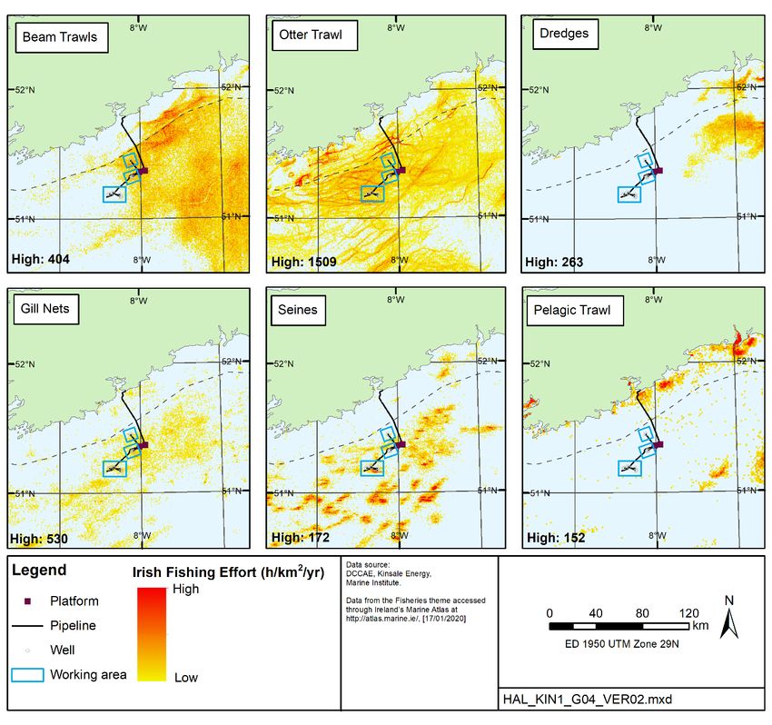
Kinsale Area Subsea Wells Rig Site                                                          PSE Kinsale Energy Limited
Geophysical Survey:                                                                                       March 2020
                                                                                                                Page i
Fisheries Assessment

Contents
Glossary .................................................................................................................... ii
1     Introduction ........................................................................................................ 1
    1.1     The Applicant .............................................................................................. 1
    1.2     Background and document purpose ......................................................... 1
2     Project Description ............................................................................................ 4
    2.1     Survey background and purpose .............................................................. 4
    2.2     Survey activity and equipment .................................................................. 4
    2.3     Vessel ........................................................................................................... 5
3     Fisheries Baseline Information......................................................................... 7
    3.1     Fish and shellfish ........................................................................................ 7
    3.2     Fisheries .................................................................................................... 11
4     Fishery Assessment ........................................................................................ 16
    4.1     Introduction ............................................................................................... 16
    4.2     Physical presence of survey vessel ........................................................ 16
    4.3     Underwater noise ...................................................................................... 16
    4.4     Accidental events ...................................................................................... 21
    4.5     Cumulative effects .................................................................................... 22
    4.6     Fisheries stakeholder engagement ......................................................... 22
5     Conclusion ....................................................................................................... 24
6     References ....................................................................................................... 25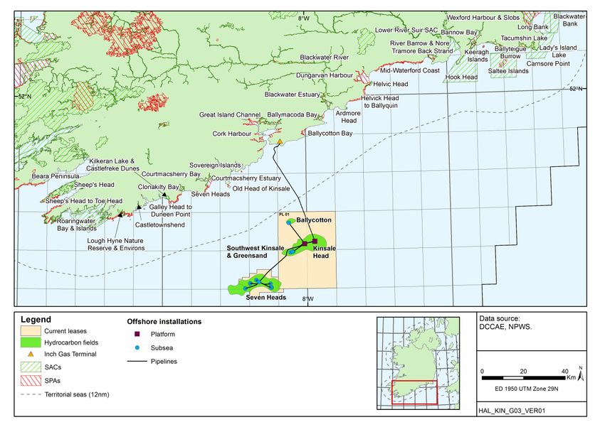
Kinsale Area Subsea Wells Rig Site                                    PSE Kinsale Energy Limited
Geophysical Survey:                                                                 March 2020
                                                                                         Page ii
Fisheries Assessment

GLOSSARY
   Term                                           Definition
AA            Appropriate Assessment
AIS           Automatic Identification System
BOEM          US Bureau of Ocean Energy Management
CFP           Common Fisheries Policy is a set of rules for managing European fishing fleets and
              for conserving fish stocks in the EU.
CSHAS         Celtic Sea Herring Acoustic Survey
dB            Decibel, a logarithmic unit to measure sound level
DCCAE         Department of Communications, Climate Action and Environment
DCENR         Department of Communications, Energy and Natural Resources
DP            Dynamic positioning
EIA           Environmental Impact Assessment
EIAR          Environmental Impact Assessment Report
EU            European Union
GES           Good Environmental Status
HRGS          High-Resolution Geophysical Survey
ICES          International Council for the Exploration of the Sea
KA            Kinsale Alpha
KB            Kinsale Bravo
MODU          Mobile Offshore Drilling Unit
MSFD          Marine Strategy Framework Directive
Natura 2000   Natura 2000 is a network of nature protection areas in the territory of the
              European Union. It is made up of Special Areas of Conservation (SACs) and
              Special Protection Areas (SPAs) designated respectively under the Habitats
              Directive and Birds Directive.
NMFS          National Marine Fisheries Service, U.S. Department of Commerce
Pa            Pascal unit of sound pressure
PAD           Petroleum Affairs Division of the Department of Communications, Climate Action and
              Environment
SBP           Sub-Bottom Profiler
SFPA          Sea Fisheries Protection Authority
TAC           Total Allowable Catch. Member States are allocated a proportion of TACs through the
              CFP which become the national quota.
USBL          Ultra-Short Baseline (acoustic positioning)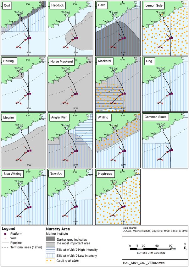
Kinsale Area Subsea Wells Rig Site                                    PSE Kinsale Energy Limited
Geophysical Survey:                                                                 March 2020
                                                                                         Page 1
Fisheries Assessment

1          INTRODUCTION
1.1        The Applicant
PSE Kinsale Energy Limited (Kinsale Energy) is applying for consent to undertake survey
activities at the Ballycotton and Southwest Kinsale fields (Petroleum Lease area No.1), and
the Seven Heads field (Seven Heads Petroleum Lease) in the North Celtic Sea Basin. The
survey area is located off the coast of Co. Cork, at a distance of between 26km and 40km
from the nearest landfall (Figure 1.1).

Discovery of the Kinsale Head area gas reserves were made by Marathon Oil in 1971, and
production commenced in 1978 following the installation of the KA and KB platforms.
Subsequent discoveries were made in the Kinsale Head area including Ballycotton,
Southwest Kinsale and the Seven Heads fields and developed as subsea tie-backs to the
Kinsale Head platforms.

1.2        Background and document purpose
Kinsale Energy is preparing for the decommissioning of the Kinsale Area gas fields and
facilities which are coming to the end of their productive life, and in keeping with lease
obligations have prepared Decommissioning Plans and related Environmental Impact
Assessment Report (EIAR) and Appropriate Assessment (AA) screening reports, which have
been submitted to the Petroleum Affairs Division (PAD) of the Department of
Communications, Climate Action & Environment (DCCAE). To inform well abandonment for
the subsea facilities associated with the Seven Heads, South West Kinsale, Greensands and
Ballycotton Fields, a survey is proposed to investigate water depths, seabed and shallow
geological conditions (for rig siting), to identify any obstructions and confirm the locations of
existing Kinsale infrastructure (e.g. pipelines and wellheads). The survey will include the use
of equipment (e.g. single beam and multi-beam echosounder, sidescan sonar, sub-bottom
profiler, magnetometer) to characterise the seabed and detect the nature and depth of the
shallow geology, and any obstructions, at each field (more detail is provided in Section 2).

1.2.1      EIA Screening
An EIA screening report has been prepared to fulfil the requirements of the EIA Directive by
providing an environmental appraisal of the potential for direct and indirect significant effects
of the proposed survey programme, in order to provide the relevant information to allow the
Competent Authority to make a screening decision on whether an Environmental Impact
Assessment (EIA) is required, and whether consent for the activities can be granted.

1.2.2      AA Screening
An AA screening exercise has been undertaken to consider the potential for likely significant
effects to arise in relation to Natura 2000 sites from activities associated with the proposed
survey. The outcome of the AA screening exercise is documented in a separate Screening
for Appropriate Assessment report, which considers the implications of the proposed survey,
on its own and in combination with other plans or projects, for European sites in view of the
conservation objectives of those sites.
Kinsale Area Subsea Wells Rig Site                                 PSE Kinsale Energy Limited
Geophysical Survey:                                                              March 2020
                                                                                      Page 2
Fisheries Assessment

1.2.3      Pre-survey fisheries assessment
The survey programme is focussed on areas in and around existing Kinsale facilities, and
the statutory 500m safety exclusion zones around these, the wider survey working areas will
extend into a broader area of approximately 4km around each of the subsea wells (see
Section 2). The fisheries baseline is described in Section 3 and the potential for interaction
with fisheries activities is considered in Section 4.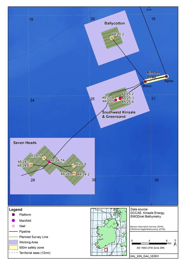
Kinsale Area Subsea Wells Rig Site                          PSE Kinsale Energy Limited
Geophysical Survey:                                                       March 2020
                                                                               Page 3
Fisheries Assessment

 Figure 1.1: Location of the Kinsale Area infrastructure and proposed survey areas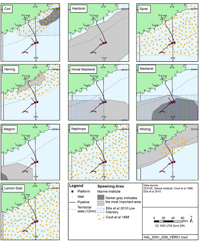
Kinsale Area Subsea Wells Rig Site                                    PSE Kinsale Energy Limited
Geophysical Survey:                                                                 March 2020
                                                                                         Page 4
Fisheries Assessment

2         PROJECT DESCRIPTION
2.1       Survey background and purpose
As noted in Section 1, Kinsale Energy is preparing for the decommissioning of the Kinsale
Area gas fields and facilities, which include the subsea fields of Southwest Kinsale,
Greensand, Ballycotton and Seven Heads. Two applications have been made in relation to
the decommissioning of the Kinsale area facilities which were each accompanied by an
EIAR and AA screening1. These applications covered; facilities preparation, well plug and
abandonment, platform topsides and subsea structure removal (application no. 1); and
jacket removal (application no. 2).

As noted in the decommissioning programme for application no. 1 (see Section 3 of the
related EIAR), it is proposed that the wells relating to the subsea fields will be
decommissioned either using a semi-submersible mobile offshore drilling unit (MODU)
and/or a light well intervention vessel. In order to facilitate well abandonment, an
understanding of the anchoring conditions is required as well as whether there are any
obstructions around each of the fields.

This Pre-survey Fisheries Assessment Report has been prepared to cover the proposed
survey elements of well decommissioning only. The approach to decommissioning and
related sources of potential effect have already been detailed and assessed as part of
application no. 1 and will not be considered again here.

2.2        Survey activity and equipment
The specific equipment to be used as part of the survey is yet to be selected, but the range
of equipment which could be deployed is listed in Table 2.1, and all are considered in terms
of their potential impact with respect to fisheries in Section 4. The selected equipment will
not differ substantially from those listed in Table 2.1 such that the scale or nature of potential
effects will not differ from those assessed in this report.

Line plans for each survey element are shown in Figure 2.1, which includes a working area
allowing for line turns when using towed equipment (marked as such in Figure 2.1). It is
planned that the survey will take place between April to September 2020 and is expected to
be completed in approximately 7.5 days.

                   Table 2.1: Summary of potential survey equipment
   Potential equipment                      Source type                   Operating frequency
Edgetech 2400                 Pinger/chirp SBP (towed)                 1-16kHz
Edgetech 3300                 Pinger/chirp SBP (hull-mounted)          1-16kHz
Edgetech 4200                 Side-scan sonar (towed)                  100kHz & 500kHz
Kongsberg EM710               Multi-beam echosounder                   70-100kHz
Kongsberg EM400               Single beam echosounder                  35-200kHz

1
  See: https://www.dccae.gov.ie/en-ie/natural-resources/topics/Oil-Gas-Exploration-
Production/environment/statutory-consents/ministerial-decisions/decommissioning-kinsale-head-and-
seven-heads-
facilities/Pages/Decommissioning%20Kinsale%20Head%20and%20Seven%20Heads%20Facilities.as
px and https://www.dccae.gov.ie/en-ie/natural-resources/consultations/Pages/Decommissioning-of-
certain-facilities-within-the-Kinsale-Head-Petroleum-Lease-area.aspx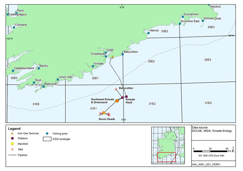
Kinsale Area Subsea Wells Rig Site                               PSE Kinsale Energy Limited
Geophysical Survey:                                                            March 2020
                                                                                    Page 5
Fisheries Assessment

   Potential equipment                  Source type                Operating frequency
Geometrics G882            Magnetometer                          NA - passive
Kongsberg HiPAP 502        USBL (ultra-short baseline acoustic   20-35kHz
                           positioning; hull-mounted with
                           transponder on towed device)

2.3       Vessel
The vessel to complete the survey programme has not yet been selected. For the purposes
of this assessment, a representative vessel has been assumed (e.g. RV Celtic Explorer, RV
Ocean Researcher or equivalent).
Kinsale Area Subsea Wells Rig Site PSE Kinsale Energy Limited
Geophysical Survey: March 2020
Page 6
Fisheries Assessment
Figure 2.1: Proposed survey lines, survey working areas, and Kinsale Area
infrastructure including wellsKinsale Area Subsea Wells Rig Site PSE Kinsale Energy Limited
Geophysical Survey: March 2020
Page 7
Fisheries Assessment
3 FISHERIES BASELINE INFORMATION
3.1 Fish and shellfish
The waters of southern Ireland support a diversity of fish and shellfish, including a number of
commercially valuable species. Fish assemblages tend to be closely associated with
particular physical environments, with temperature, depth and sediment type all influencing
the community composition (see Gerritsen & Kelly 2019 for a description of relevant fishing
grounds). The southern Irish coast acts as a gateway to the wider Atlantic from the enclosed
waters of the Bristol Channel and Irish Sea. Pelagic species, including herring (Clupea
harengus), mackerel (Scomber scombrus), sprat (Sprattus sprattus) and horse mackerel
(Trachurus trachurus) are abundant in the region, and move widely between feeding and
spawning grounds (Heessen et al. 2015). The most abundant species in the region are
haddock (Melanogrammus aeglefinus), poor cod (Trisopterus minutus), Norway pout
(Trisopterus esmarkii) and whiting (Merlangius merlangus) (Marine Institute 2012), while cod
(Gadus morhua), monkfish (Lophius piscatorius), hake (Merluccius merlucius), plaice
(Pleuronectes platessa) and dab (Limanda limanda) are also abundant (Heessen et al.
2015). The areas of sandy sediment tend to support flatfish and sandeels, while gobies,
blennies, wrasse and large gadoids are more abundant over rockier regions (Boelens et al.
1999). There are important Nephrops norvegicus (Norway lobster, scampi) grounds to the
south of Cork (Lordan et al. 2015).
The subsea fields are located within ICES Rectangles 31E1 and 31E2 (see Figure 3.3).
Table 3.1 shows that the proposed survey location overlaps or is close to known spawning
grounds and nursery areas for certain fish species. Rectangle 31E2 is within the spawning
areas for herring, sprat, cod, whiting, plaice, lemon sole and Nephrops (Coull et al. 1998), as
well as haddock, megrim (Lepidorhombus whiffiagonis) and horse mackerel (Marine Institute
data – see Figure 3.1). In addition Ellis et al. (2012) identified low spawning activity for
mackerel in the area. Mackerel, cod, whiting, lemon sole, blue whiting (Micromesistius
poutassou), ling (Molva molva), European hake, sandeels (Ammodytes spp.) and Nephrops
all use the area as a nursery area at low intensity, while the area is a high intensity nursery
area for monkfish (Ellis et al. 2012). The Marine Institute have also identified nursery
grounds for herring, haddock, megrim and horse mackerel, in addition to whiting and
mackerel (Figure 3.2). The area is not located within any known elasmobranch spawning
grounds but was identified within a low intensity nursery ground for spurdog (Squalus
acanthias) (Ellis et al. 2012). Fish spawning can vary temporally and spatially; spawning
areas are not rigidly fixed and fish may spawn earlier or later in the season.
A number of elasmobranch species are present in the region, including the spurdog and the
lesser spotted dogfish (Scyliorhinus canicula) (Marine Institute 2012). Aerial surveys from
2015-2016 for the ObSERVE project reported multiple sightings of blue sharks in the
offshore Celtic Sea region in summer (Rogan et al. 2018). Other oceanic sharks such as
thresher (Alopias vulpinus) and mako (Isurus oxyrinchus) sharks may make occasional,
seasonal visits to the region. The southern Irish coast is an area where basking sharks are
particularly common, with numerous sightings reported annually in the summer months
(Solandt & Chassin 2014).
Aerial surveys from 2015-2016 in the ObSERVE project reported ocean sunfish (Mola mola)
to be frequently observed in most offshore waters around Ireland, including off the south
coast where most sightings were recorded in summer (Breen et al. 2017, Rogan et al. 2018).
For offshore waters of the Celtic Sea, design-based estimates of 4,625 (95% CI 2,679-
7,987) and 2,068 (95% CI 1,398-3061) were produced for the two summer surveys, andKinsale Area Subsea Wells Rig Site PSE Kinsale Energy Limited
Geophysical Survey: March 2020
Page 8
Fisheries Assessment
1,044 (95% CI 606-1,799) and 73 (95% CI 14-375) for the two winter surveys (Rogan et al.
2018).
The River Lee contains populations of the diadromous species Atlantic salmon (Salmo salar)
and brown trout (Salmo trutta), which migrate from the sea to spawning locations up-river.
Salmon runs take place through the summer, with June to September particularly fruitful for
anglers.
Table 3.1: Spawning and nursery grounds in the Kinsale Area
Species Spawning grounds Nursery grounds Spawning period
Herring (a,c) January - March
Sprat (a) - May - August
Mackerel (b,c) (low) March - July
Horse mackerel (c) March - August
Blue whiting (b) - (low) -
Cod (a,b,c) (low) January - April
Haddock (c) February – May
Whiting a,b,c) (low) February - June
Hake (b,c) - (low) -
Ling (b) - (low) -
Plaice (a) - December - March
Lemon sole (a) April - September
Megrim (c) January - March
Monkfish (b,c) - (high) -
Spurdog (b) - (low) -
Common skate (b) - (low) -
Nephrops (a) January - December
Sources: a = Coull et al. (1998), b = Ellis et al. (2012), c = Marine Institute (2012) – spawning period
detail taken from Coull et al. (1998) and Ellis et al. (2012)Kinsale Area Subsea Wells Rig Site PSE Kinsale Energy Limited
Geophysical Survey: March 2020
Page 9
Fisheries Assessment
Figure 3.1: Fish spawning areasKinsale Area Subsea Wells Rig Site PSE Kinsale Energy Limited
Geophysical Survey: March 2020
Page 10
Fisheries Assessment
Figure 3.2: Fish nursery areasKinsale Area Subsea Wells Rig Site PSE Kinsale Energy Limited
Geophysical Survey: March 2020
Page 11
Fisheries Assessment
3.2 Fisheries
The seas around Ireland are among the most productive in EU waters and most fisheries
resources come under the remit of the Common Fisheries Policy (CFP). The overall 2019
fishing opportunities (i.e. Total Allowable Catches, TAC's species) for stocks to which the
Irish fleet has access to, were 1.15 million tonnes of fish, with an estimated landed value of
€1.44 billion. Ireland's total share of these TACs in 2019 amounted to 193,924 tonnes with a
value of €216 million2 (Marine Institute 2019). The largest ports near the Kinsale Area are
Castletownbere and Dunmore East, which are both among the top four ports (by landings) in
Ireland (SFPA website3). Of the more local ports, the most significant in 2019 were Union
Hall (1,857 tonnes, €8.2 million), Kinsale (1,030 tonnes, €2.6 million) and Kilmore Quay
(3,653 tonnes, €10.6 million) (SFPA website) (see Figure 3.3).
The dominant fishing method in the area is demersal (otter) trawling, which is, in the waters
around the survey area, mainly used to catch Nephrops, haddock and whiting (Gerritsen &
Kelly 2019). Other gears in use in the area include pelagic trawls (predominantly targeting
herring in the area), seine nets (targeting haddock and whiting) and gill nets (targeting
pollack and hake) (Gerritsen & Kelly 2019). Anatec (2017) conducted a survey of fishing
activity within the Kinsale Area. A monthly count4 of fishing vessels over 2015/16 showed
the busiest month to be February, with 540 vessel-days recorded by 77 different vessels and
the quietest month, December with 277 vessel-days recorded from 66 different vessels
(Figure 3.4). The most common gear types were single demersal trawlers (30%), single
pelagic trawlers (20%), gill netters (19%), beam trawlers (8%) and long liners (7%). Purse
seines, twin trawlers (which may be demersal or pelagic) and dredgers all contributed 4%,
while potters/whelkers contributed 2%, primarily in coastal waters. Over 90% of all vessels
were Irish-registered, and 70% were registered to ports on the south coast.
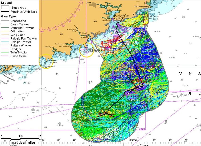
Vessels estimated to be actively fishing in the Kinsale Head area, colour-coded by gear-
type, are presented in Figure 3.5, based on 18 months of AIS (Automatic Identification
System) analysis (Anatec 2017). The majority of active fishing was from vessels with
demersal gear (including single demersal trawlers, beam trawlers and dredger). On average
there were approximately four demersal vessels per day actively fishing within the area
highlighted on Figure 3.5.
The south coast of Ireland is of particular importance for smaller vessels (10m must report
their movements into and out of the zone, and record their catch every two hours. ICES
rectangles are used for fisheries data recording and management5. Table 3.6 lists the
weight and value of landings from the Kinsale Area rectangles (se Figure 3.3) over the
period 2014-2016.
2
These values do not include the valuable inshore fisheries (e.g. lobster, whelk) which are not
managed using internationally agreed TACs but do come within the remit of the CFP. These inshore
fisheries resources represent a very important resource base for the coastal communities around
Ireland (Marine Institute 2019).
3
https://www.sfpa.ie/Statistics/Annual-statistics/Annual-Statistics/2018-Statistics
4
The monthly count is taken as number of vessel-days per month, which is defined as the number of
unique vessels per day summed for each month (Anatec 2017).
5
Long term management plans of relevance to the mixed demersal fisheries in the area include the
recently adopted Western Waters multi-annual plan for demersal species (Marine Institute 2019).Kinsale Area Subsea Wells Rig Site PSE Kinsale Energy Limited
Geophysical Survey: March 2020
Page 12
Fisheries Assessment
Figure 3.3: Fishing ports in the region
Figure 3.4: AIS fishing vessel monthly count (2015/16)
Source: Anatec (2017).Kinsale Area Subsea Wells Rig Site PSE Kinsale Energy Limited
Geophysical Survey: March 2020
Page 13
Fisheries Assessment
Figure 3.5: Vessels estimated to be actively engaged in fishing (2014 & 2015/16)
Source: Anatec (2017)
Table 3.2: Weight and value of landings from ICES rectangles 31E1, 31E2 & 32E1,
2014-2016
2014 2015 2016
Species Live Live Live
type weight Value (€) weight Value (€) weight Value (€)
(tonnes) (tonnes) (tonnes)
31E1
Pelagic 178 88,257 38 12,646 2 1,331
Demersal 1,407 3,127,042 1,993 4,429,025 2,244 4,866,119
Shellfish 103 705,903 128 878,350 172 1,185,287
Total 1,689 3,921,201 2,159 5,320,021 2,418 6,052,738
31E2
Pelagic 5,458 1,779,804 1,706 558,566 84 27,951
Demersal 1,739 3,700,550 1,982 4,313,845 1,795 3,859,776
Shellfish 34 195,763 56 326,403 36 222,516
Total 7,231 5,676,123 3,744 5,198,815 1,915 4,110,243
32E1
Pelagic 815 156,201 277 99,996 457 116,872
Demersal 511 1,152,666 325 785,269 368 817,341Kinsale Area Subsea Wells Rig Site PSE Kinsale Energy Limited
Geophysical Survey: March 2020
Page 14
Fisheries Assessment
2014 2015 2016
Species Live Live Live
type weight Value (€) weight Value (€) weight Value (€)
(tonnes) (tonnes) (tonnes)
Shellfish 138 950,196 130 890,759 134 875,031
Total 1,463 2,259,063 732 1,776,024 959 1,809,244
Grand Total 10,383 11,856,387 6,636 12,294,859 5,291 11,972,224
Source: Compiled from data supplied by Sea Fisheries Protection Authority (SFPA)
Over the period 2014-2016, reported landings from these rectangles were largely dominated
by demersal fish species. Total landings have remained relatively similar across the three
years, although there were very high catches of pelagic species (mostly herring) in ICES
rectangle 31E2 in 2014 and 2015, a region where high abundances of herring and sprat are
reported (O’Donnell et al. 2016). Lower total landings in 32E1 than in 31E1 and 31E2 may
be attributed in part to the smaller available fishing area of this coastal rectangle (see Figure
3.3), as well as the predominance of smaller, inshore vessels in these areas. Pelagic fish
are usually caught in large quantities, but at low value (a tonne of herring averages €326),
while several demersal species and, particularly shellfish, attract high market values (cod
may fetch €2,519/tonne, monkfish €3,326/tonne, Nephrops €6,920/tonne and lobster
€13,781/tonne), and thus, with a slight increase in demersal landings over this period, the
total value has remained very similar.
Figure 3.6 illustrates the fishing effort around the Kinsale Area. Clear areas of greater effort
by otter trawl can be seen. These areas correlate with muddy sediments where small but
productive Nephrops grounds are located (Lordan et al. 2015, Gerritsen & Kelly 2019).
The current status of commercial fish and shellfish populations was considered in relation to
MSFD Descriptor 36 as part of the Initial Assessment of Ireland’s marine waters (Marine
Institute 2013). This initial assessment has recently been updated and is currently being
consulted upon7 as part of the second MSFD implementation cycle. The assessment
indicates that thirty-four stocks are considered to be compatible with Good Environmental
Status (GES), while 44 stocks are not. The compatibility of 99 stocks in relation to GES is
unknown. Overall, the assessment concluded that the status of commercial fish and
shellfish stocks is not fully compatible with GES.
6
Populations of all commercially exploited fish and shellfish are within safe biological limits, exhibiting
a population age and size distribution that is indicative of a healthy stock.
7
https://www.housing.gov.ie/sites/default/files/public-
consultation/files/msfd_public_consultation_report_december_2019.pdfKinsale Area Subsea Wells Rig Site PSE Kinsale Energy Limited
Geophysical Survey: March 2020
Page 15
Fisheries Assessment
Figure 3.6: Fishing effort in the Kinsale Area, 2014-2018Kinsale Area Subsea Wells Rig Site PSE Kinsale Energy Limited
Geophysical Survey: March 2020
Page 16
Fisheries Assessment
4 FISHERY ASSESSMENT
4.1 Introduction
This fishery assessment forms part of a suite of assessments to be submitted as part of the
application for approval of the proposed survey activities, including an EIA screening and an
Appropriate Assessment Screening Statement. The assessment considers those potential
effects on fisheries identified through the EIA screening process of the proposed survey
activities. The assessment has been undertaken on the basis of the survey methods
described in Section 2. These include a worst case assessment (e.g. in terms of vessel
timings and the range of potential equipment which could be used), such that those effects
described below will not be exceeded, regardless of the final equipment selected.
The EIA screening process identified the following sources of potential effects of relevance
to fisheries:
Physical presence of survey vessel
Noise generated from survey equipment and survey vessel
Accidental events
Cumulative effects
4.2 Physical presence of survey vessel
The dominant fishing method in the area is demersal (otter) trawling, which is, in the waters
around the survey area, mainly used to catch Nephrops, haddock and whiting (Gerritsen &
Kelly 2019). The Anatec (2017) survey indicated that on average in 2015/16 there were
approximately four demersal vessels per day actively fishing within the area highlighted on
Figure 3.5, with most vessels in February, October and March.
There is the potential for interaction with fishing vessels, but this is limited by the small
working area of the survey vessel relative to the wider Kinsale Area and Celtic Sea.
Interactions are largely limited to the survey vessel in transit or any time spent outside of the
safety zones in the greater working areas, which represents a minor increment to existing
supply and support activity. The vessel is estimated to be present for one week, and the
activities will be advertised through relevant notices to mariners. It is planned that the
survey will take place between April to December 2020.
4.2.1 Conclusions
Given the limited duration of the planned survey by a single vessel, the low number of fishing
vessels likely to be present within the general area and that activities will primarily occur
within long-established statutory exclusions zones, the risk of displacement of fishing
activities due to the presence of the survey vessel is considered to be extremely
remote and significant effects are not considered to be likely.
4.3 Underwater noise
Anthropogenic noise in the marine environment is widely recognised as a potentially
significant concern to marine fauna, especially in relation to marine mammals. However
much attention has also been given to effects on fish. Potential (and postulated) effects of
anthropogenic noise on receptor organisms range from acute trauma to subtle behaviouralKinsale Area Subsea Wells Rig Site PSE Kinsale Energy Limited
Geophysical Survey: March 2020
Page 17
Fisheries Assessment
and indirect ecological effects (e.g. effects on prey species). The sources, measurement,
and propagation of anthropogenic underwater noise, along with the auditory abilities of
marine fauna, evidence of effects and potential mitigation have been extensively reviewed
and assessed (e.g. Richardson et al. 1995, McCauley et al. 2000, Southall et al. 2007, 2019,
Popper et al. 2014, Carroll et al. 2017). Further, seismic survey effects on the UK and Irish
marine environment have been extensively assessed; for example the UK Offshore Energy
SEAs (DECC 2009, 2011, 2016) and SEAs for offshore energy in Irish waters (e.g. DCENR
2011) provided detailed strategic assessments at a regional scale.
4.3.1 Noise sources and propagation
As outlined in Section 2, the planned survey will use high-resolution geophysical survey
(HRSG) sources to obtain information on the seabed, existing infrastructure, potential
obstructions and anchoring conditions around the Seven Heads, Ballycotton and South-West
Kinsale/Greensands areas. All acoustic sources are electromechanical and use a
piezoelectric transducer(s) to transmit a computer-generated frequency-amplitude
modulated signal of pre-determined pulse length and frequency. The lowest frequency
source which may be used is a pinger or chirp sub-bottom profiler (SBP); no airgun, sparker
(electrostatic discharge) or boomer (accelerated water mass) will be used. Chirp SBPs
typically sweep through a range of frequencies from a lower bound of approximately 1-2kHz.
Calibrated measurements of the acoustic characteristics of electromechanical sources used
in HRGS have, until recently, been lacking, with assessments reliant upon manufacturer
specifications. However, a recent study commissioned by the US Bureau of Ocean Energy
Management (BOEM) provided calibrated measurements of source characteristics under
controlled test tank conditions for a variety of equipment used in HRGSs (Crocker &
Fratantonio 2016, Crocker et al. 2019). Table 5.1 summarises indicative source
characteristics of the equipment (and comparable equipment) which will potentially be used
in the planned Kinsale survey, drawing on results of Crocker & Fratantonio (2016)
supplemented by manufacturer specifications where required. Source levels provided are
those reported for the sources operated at the maximum power tested. In addition to those
sources described in Table 4.1, there may be the use of an ultra-short baseline (USBL)
system to monitor the position of towed equipment. The USBL system consists of a multi-
element transducer mounted on the hull of the vessel and a transponder attached to the
towed equipment (e.g. side-scan sonar). The hull-mounted transducer emits an acoustic
pulse that is detected by the transponder, which replies with its own acoustic pulse, and its
position is subsequently determined from the range and angle of the pulse as received by
the transducer. USBL equipment is widely used by offshore commercial and research
vessels where positional accuracy of towed survey equipment is critical. The emitted pulses
will be short pulse width ‘pings’, approximately in the range of 20-35kHz and with a source
level of up to ~200dB re 1μPa @1m (peak).Kinsale Area Subsea Wells Rig Site PSE Kinsale Energy Limited
Geophysical Survey: March 2020
Page 18
Fisheries Assessment
Table 4.1: Potential acoustic survey equipment and indicative source characteristics
Indicative source characteristics
Potential equipment Nominal Beam width
operating Source level (degrees)
frequency
(1)
Hull-mounted pinger/chirp 1-16kHz 212dB re 1μPa @1m 20-40
(1)
SBP e.g. Edgetech 3300 (peak)
(2)
Towed pinger/chirp SBP 1-16kHz 186-187dB re 1μPa @1m 51-80
(2) (2)
e.g. Edgetech 2400 (peak)
Side-scan sonar 100kHz & 500kHz 206-210 dB re 1μPa @1m 1.6-2.6 along
(3) (3)
e.g. Edgetech 4200 (peak) track; ~50 across
(3)
track per beam
Multi-beam echosounder 70-100kHz 214-228dB re 1μPa @1m 1.5-6.0 along
(4) (4)
e.g. Kongsberg EM710 (peak) track; ~160
(4)
across track
(5)
Single beam echosounder 35-200kHz 192-197dB re 1μPa @1m 7.0
(5) (5)
e.g. Kongsberg EM400 (peak)
Notes: (1) manufacturer-specified; beam width varies with operating frequency and
transducer configuration. Source characteristics are manufacturer-specified unless stated
otherwise. (2) Manufacturer-specified source level and beam width not available for the
Edgetech 2400 towed SBP, so values (calibrated measurements) are taken for the
comparable Edgetech 512i and 424 towed chirp SBPs reported in Crocker & Fratantonio
(2016). (3) Calibrated measurements for Edgetech 4200 tested at 100kHz and 400kHz
reported in Crocker & Fratantonio (2016). (4) Manufacturer-specified source level not
available for the Kongsberg EM710, so values (calibrated measurements) are taken for the
comparable Reson Seabat 7111 MBES operated at a central frequency of 100kHz reported in
Crocker & Fratantonio (2016). (5) Manufacturer-specified source level and beam width not
available for the Kongsberg EM400, so values (calibrated measurements) are taken for the
comparable Teledyne Echotrac CV100 operated at a central frequency of 200kHz reported in
Crocker & Fratantonio (2016).
The propagation of sound in the marine environment is complex and has been the subject of
considerable research (e.g. Wang et al. 2014). Once a sound is emitted, its characteristics
will be altered with distance from source. Changes will affect the amplitude of the signal and
its frequency content and, in the case of impulsive sounds, the injurious elements will be
reduced through propagation (i.e. pulse duration increases and rise-time decreases with
distance). The main process that reduces the amplitude of the sound wave as it propagates
is geometrical spreading; while a host of other processes come into play (e.g. reflection,
refraction, scattering, reverberation and absorption), many of which are dependent on
environmental conditions. The effect of frequency-dependent absorption loss is small on
lower frequency sources (e.g. 230dB re 1 µPa can be expected in close proximity (metres); levels are
commonly reported to have decreased below 200dB re 1 µPa at a range of 100-1000m, and
below 160 re 1 µPa at a range of 10-11km (e.g. Breitzke et al. 2008).Kinsale Area Subsea Wells Rig Site PSE Kinsale Energy Limited
Geophysical Survey: March 2020
Page 19
Fisheries Assessment
The emitted sound fields from HRGS sources such as SBPs, side-scan sonar and
echosounders are of much lower amplitude and extent compared to seismic surveys using
airguns due to their lower source levels, higher central operating frequencies and greater
directionality (narrower beam widths) (e.g. Boebel et al. 2005, Genesis 2011). However,
very few empirical field data are available to quantify these expectations. The most relevant
work to date is part of the study funded by the US BOEM: following the calibrated
measurements of Crocker & Fratantonio (2016), measurements were made in shallow (≤
100m depth) open-water environments to investigate the propagation of sound from various
HRGS sources (Halvorsen & Heaney 2018). Problems were encountered during the open-
water testing resulting in a lack of calibration in the reported sound source levels (Labak
2019). The accompanying advice note (Labak 2019) emphasises that these uncalibrated
data should not be used to provide source level measurements, and consequently the
reported isopleths (summarising sound propagation) should not replace project-specific
sound source verifications. A further project to calibrate these measures and provide an
expanded assessment of propagation commenced in 2019.
Despite these caveats, it is worth noting some general patterns observed in Halvorsen &
Heaney (2018). In all test environments, broadband received levels from all SBP chirper8,
echosounder and side-scan sonar devices tested were rapidly attenuated with distance from
source, with particularly pronounced fall-off for directional sources when the receiver was
outside of the source’s main beam. The greatest propagation was generally observed at the
deepest test site (100m water depth) from sources generating low frequencies (50kHz)
experienced such attenuation that they were only weakly detectable or undetected by
recording equipment. In all open-water test environments, broadband received levels did not
exceed 160dB re 1μPa (rms)9 beyond 200m from any chirper SBP, echosounder or side-
scan sonar device tested. While recognising that these results require refining, preliminary
evidence suggests that these electromechanical HRGS sources generate a very limited
sound field in the marine environment, and of a much lower magnitude than those generated
by seismic airgun sources. While independently-measured sound fields are not available for
USBL, their nominal source levels and central operating frequencies are such that emitted
sounds fields are likely to be very small and of limited/no audibility above that of the
concurrently operating survey equipment and vessel.
In generic terms, underwater noise emitted by small leisure craft and vesselsKinsale Area Subsea Wells Rig Site PSE Kinsale Energy Limited
Geophysical Survey: March 2020
Page 20
Fisheries Assessment
Cavitational noise commonly arises at speeds between 8 and 12 knots and grows in
amplitude with increasing speed; its frequency spectrum is broad with dominant frequencies
above a few hundred Hz. In addition to vessels in transit, cavitational noise is important
when vessels are operating under high load conditions (high thrust) and when dynamic
positioning (DP) systems are in use. For example, the use of thrusters for DP has been
reported to result in increased sound generation of ~10dB compared to the same vessel in
transit: measurements at 600m range to an offshore supply vessel of 79m length recorded
broadband SPL (18-3,000Hz) of 148.0dB re 1μPa (root-mean-squared, rms) when in DP
mode, compared to 135.5dB re 1μPa rms when in transit at a speed of 10 knots (Rutenko &
Ushchipovskii 2015).
Acoustic modelling in support of oil & gas operations have shown that across a variety of
vessels, activities and localities, exposure to sound pressure level (SPL) above >180 dB re 1
μPa rms is highly unlikely; SPL >160 dB re 1 μPa rms are encountered only within the
immediate vicinity of the activity (120 dB re 1 μPa rms are encountered
up to a few kilometres (Neptune LNG 2016, Fairweather 2016, Owl Ridge Natural Resource
Consultants 2016).
4.3.2 Fish and fisheries
Fish exhibit large variation in their response to sound, largely due to the great diversity in
anatomical features, hearing physiology and behaviour; all species respond to particle
motion, but several have adaptations that make them sensitive also to the pressure
component of sound. Most species can detect sounds from 213dB re 1 µPa (peak) and for all other groups is >207dB re 1 µPa (peak).
There have been numerous reviews of the effects of anthropogenic sound on fish (e.g.
Popper et al. 2014, Hawkins et al. 2015, Slabbekoorn et al. 2019). Of relevance is Carroll et
al. (2017), who present a systematic and critical review of scientific studies investigating the
impacts of low-frequency sound on marine fish, with a focus on seismic surveys. Of studies
investigating adult/juvenile fish mortality and physical injury, the majority showed no effects,
some reported temporary hearing loss and one observed long-term hearing damage; none
showed mortality. Of six studies investigating mortality of fish eggs or larvae, none reported
mortality at realistic known exposure levels. Behavioural effects are the most studied
aspect, numbering 15 studies, with most being laboratory or caged field experiments.
Startle/alarm responses, avoidance of the sound source or changes in vertical or horizontal
distribution were widely reported, while several studies reported no significant response or
conflicting results. Observed responses were temporary, and fish returned to pre-exposure
behaviour typically within less than an hour of the last exposure. The majority of studies of
effects on catch rates or abundance report no effect or conflicting results, although in some
cases reduced trawl and/or longline catch occurred; where effects have been reported, these
are most likely due to changes in fish distribution and behaviour, such as vertical
movements.
As key prey items of fish, there has been increasing interest in the potential effects of
seismic and other high amplitude low-frequency noise on plankton. McCauley et al. (2017)
reported a significant decrease in zooplankton abundance and a significant increase in
mortality of adult and larval zooplankton, particularly krill, following repeated exposure to aKinsale Area Subsea Wells Rig Site PSE Kinsale Energy Limited
Geophysical Survey: March 2020
Page 21
Fisheries Assessment
150in3 airgun. By contrast, Fields et al. (2019) found only limited effects on mortality of the
copepod Calanus finmarchicus (a key food source of commercial fish in the North Atlantic)
when exposed to single blasts of a 2x260in3 airgun cluster. While studies are limited, and
further investigation is required, most evidence to date suggests negligible effects on
plankton from exposure to seismic survey noise (Carroll et al. 2017); it is reasonable to infer
that the potential for effects from lower-amplitude acoustic surveys sources will be
proportionally less.
Given the reported hearing ranges of fish, it is anthropogenic sound sources generating high
amplitude low-frequency noise (i.e. seismic airgun surveys, along with percussive pile-
driving and explosions) which are of primary concern to fish. Studies which have
experimentally tested the effects of other fairly low-frequency acoustic survey sources (i.e.
SBPs) on fish are lacking. Pinger and chirp SBPs show limited overlap only among fish
species which primarily detect sound pressure, such as herring, while the high frequency
signals generated by side-scan sonar, echosounders and USBL are above the hearing
range of fish.
4.3.3 Conclusions
Given the limited evidence of physical injury to fish from exposure to high amplitude low-
frequency seismic survey noise, and the comparatively lower amplitude and higher
frequency source characteristics of the potential sources in the planned Kinsale survey, the
risk of injury to fish is considered to be extremely remote and significant effects are
not considered to be likely.
Given the limited and variable evidence of behavioural responses of fish to high amplitude
low-frequency seismic survey noise (which are low-level and short-term), the comparative
characteristics of the potential sources in the planned Kinsale survey, in addition to the small
spatial footprint and short duration (approximately one week) of the planned survey, the risk
of significant effects on fish due to behavioural disturbance is considered to
extremely low.
Exposure to seismic survey noise during spawning or on their way to spawning grounds can
impact on a fish’s spawning success and consequently recruitment (OSPAR 2009). The
Kinsale area and proposed timing of the survey overlaps reported spawning and nursery
areas for a variety of fish species; however, given the above assessment in relation to
behavioural disturbance, significant disruption of spawning or nursery activity is not
anticipated, and significant effects are not considered to be likely.
Considering the aforementioned conclusions and that activities will primarily occur within
long-established statutory exclusions zones, no impacts on commercial fisheries in the
wider Kinsale-Ballycotton-Seven Heads area will occur.
4.4 Accidental events
The survey activities will be communicated through notices to mariners and the vessel will
display appropriate navigational lighting. In view of the duration and scale of activity (one
vessel for approximately one week), the probability of a collision with another vessel is
considered to be extremely low, such that potential effects are not considered to be likely.Kinsale Area Subsea Wells Rig Site PSE Kinsale Energy Limited
Geophysical Survey: March 2020
Page 22
Fisheries Assessment
4.5 Cumulative effects
Exola DAC, a subsidiary of Providence Resources plc has applied for approval for a site
survey in the Barryroe field (licence area SEL 1/11), some 25km from the Kinsale Bravo
platform. The survey is planned for between April and November 2020 or between February
and November 2021. The geophysical survey equipment comprises side scan sonar,
single‐beam & multi‐beam echosounders, pinger SBP, USBL and magnetometer, and the
survey is anticipated to take about 1.5 days. The Barryroe K Site Survey: EIA Screening
Report (Exola 2020) concluded that any impact from the survey on commercial fisheries
would be minor and that no significant effects are likely. The proposed Barryroe survey
overlaps with the 500m safety exclusion zones of 2 Seven Heads field wells. Exola requires
prior permission from Kinsale Energy to enter these zones, this will allow coordination of
timing of the 2 surveys such that in-combination effects would be avoided.
Marine Notice No. 11 of 2020 advises of several surveys to be undertaken in 2020 to the
south and southwest of Ireland. These surveys are part of the INFOMAR Programme
(Integrated Mapping for the Sustainable Development of Ireland’s Marine Resource), a
jointly managed seabed mapping initiative between the Geological Survey Ireland (GSI) and
the Marine Institute, funded by DCCAE. Between April and October GSI’s R.V.s Keary,
Geo, Mallet and Lir will operate in the Celtic Sea, including a survey area covering the
Kinsale Head and Seven Heads fields. Details of the GSI survey equipment are not
provided and Kinsale Energy will liaise with GSI on the timing of the various surveys with the
aim of avoiding potential in-combination effects.
Other proposed projects in the wider Kinsale Area include the Celtic Interconnector and
Ireland-France subsea cable. The timing of any works associated with these projects is not
considered likely to interact with the proposed survey schedule, and in view of the nature
and scale of potential effects on fisheries associated with the survey (Sections 4.2 to 4.4),
significant in-combination effects are not considered to be likely.
This survey is a precursor to work to be undertaken to decommission certain aspects of the
Kinsale facilities, and no interaction with activities associated with the currently approved
decommissioning programme are possible.
Kinsale Energy also propose to undertake a short (less than one day) survey in close
proximity to the Kinsale A and B platforms using a SBP, which will be subject to a separate
application. Kinsale Energy will ensure that the survey schedules are such that there will be
no temporal overlap such that cumulative effects are not considered to be likely.
4.6 Fisheries stakeholder engagement
The following relevant fisheries organisations and forums relevant were consulted with
during the preparation of the Kinsale Area Decommissioning Project:
Irish South & West Fish Producer Organisation (IS&WFPO)
Irish South & East Fish Producer Organisation (IS&EFPO)
South West Regional Fisheries Forum / (Regional Inshore Fisheries Forum)
South East Regional Fisheries Forum / (Regional Inshore Fisheries Forum)
National Inshore Fisheries Forum (NIFF)
Irish Fish Producers Organisation (IFPO)
Killybegs Fishermen’s Organisation (KFO)
Bord Iascaigh MharaKinsale Area Subsea Wells Rig Site PSE Kinsale Energy Limited
Geophysical Survey: March 2020
Page 23
Fisheries Assessment
These groups will be notified of the proposed survey vessel and timing once these are
known.Kinsale Area Subsea Wells Rig Site PSE Kinsale Energy Limited
Geophysical Survey: March 2020
Page 24
Fisheries Assessment
5 CONCLUSION
The overall conclusion of the Pre-survey Fisheries Assessment is that, in view of the
predicted scale, intensity and duration of the survey activities, the survey will not result,
directly or indirectly, in likely significant adverse effects on fisheries, alone or cumulatively
with other existing or approved projects. No residual effects are predicted to occur.Kinsale Area Subsea Wells Rig Site PSE Kinsale Energy Limited
Geophysical Survey: March 2020
Page 25
Fisheries Assessment
6 REFERENCES
Anatec (2017). Kinsale Decommissioning Fishing Risk Assessment. Prepared by Anatec Ltd on
behalf of PSE Kinsale Energy Ltd, 75pp.
Boebel O, Clarkson OP, Coates R, LArter R, O’Brien PE, Ploetz J, Summerhayes C, Tyack T, Walton
DWH & Wartzok D (2005). Risks posed to the Antarctic marine environment by acoustic instruments:
a structured analysis. Antarctic Science 17: 533-540.
Boelens RGV, Maloney DM, Parsons AP & Walsh AR (1999). Ireland’s marine and coastal areas and
adjacent seas: An environmental assessment. Marine Institute, 388pp.
Breen P, Cañadas A, Ó Cadhla O, Mackey M, Scheidat M, Geelhoed S, Rogan E & Jessopp M
(2017). New insights into ocean sunfish (Mola mola) abundance and seasonal distribution in the
northeast Atlantic. Scientific Reports 7: 2025, DOI:10.1038/s41598-017-02103-6.
Breitzke M, Boebel O, Naggar SE, Jokat W & Werner B (2008). Broad-band calibration of marine
seismic sources used by R/V Polarstern for academic research in polar regions. Geophysical Journal
International 174: 505-524.
Carroll AG, Przeslawski R, Duncan A, Gunning M & Bruce B (2017). A critical review of the potential
impacts of marine seismic surveys on fish & invertebrates. Marine Pollution Bulletin 114: 9-24.
Coull KA, Johnstone R & Rogers SI (1998). Fisheries Sensitivity Maps in British Waters. Report to
United Kingdom Offshore Operators Association, Aberdeen, 58pp.
Crocker SE & Fratantonio FD (2016). Characteristics of High-Frequency Sounds Emitted During
High-Resolution Geophysical Surveys. OCS Study, BOEM 2016-44, NUWC-NPT Technical Report
12, 203pp.
Crocker SE, Fratantonio FD, Hart PE, Foster DS, O’Brien TF & Labak S (2019). Measurement of
sounds emitted by certain high-resolution geophysical survey systems. IEEE Journal of Oceanic
Engineering 44: 796-813.
DCENR (2011). Fourth Strategic Environmental Assessment for Oil and Gas Activity in Ireland’s
Offshore Waters: IOSEA4 Irish and Celtic Seas, Environmental Report. Department of
Communications, Energy and Natural Resources, 353pp.
DECC (2009). Offshore Energy Strategic Environmental Assessment, Environmental Report.
Department of Energy and Climate Change, UK, 307pp plus appendices.
DECC (2011). Offshore Energy Strategic Environmental Assessment 2, Environmental Report.
Department of Energy and Climate Change, UK, 443pp plus appendices.
DECC (2016). Offshore Energy Strategic Environmental Assessment 3, Environmental Report.
Department of Energy and Climate Change, UK, 652pp plus appendices.
Ellis JR, Milligan SP, Readdy L, Taylor N & Brown MJ (2012). Spawning and nursery grounds of
selected fish species in UK waters. Science Series Technical Report, Cefas, Lowestoft, 147: 56pp.
Exola (2020). Barryroe K Site Survey: EIA Screening Report. Exola DAC Ref: P1250-04-01. January
2020, 74pp
Fairweather (2016). Application for incidental harassment authorization for 2016 anchor retrieval
program Chukchi and Beaufort Seas Alaska. Prepared for Fairweather LLC by Fairweather Science
LLC, April 2016.
Fields DM, Handegard NO, Dalen J, Eichner C, Malde K, Karlsen Ø, Skiftesvik AB, Durif CMF &
Browman HI (2019). Airgun blasts used in marine seismic surveys have limited effects on mortality,
and no sublethal effects on behaviour or gene expression, in the copepod Calanus finmarchicus.
ICES Journal of Marine Science: 1-12, doi:10.1093/icesjms/fsz126.
Francois RE & Garrison GR (1982). Sound absorption based on ocean measurements: Part II: Boric
acid contribution and equation for total absorption. Journal of the Acoustical Society of America
72:1879-90.
Genesis (2011). Review and Assessment of Underwater Sound Produced from Oil and Gas Sound
Activities and Potential Reporting Requirements under the Marine Strategy Framework Directive.
Report to Department of Energy and Climate Change. Genesis Oil and Gas Consultants, 72pp.
Gerritsen HD & Kelly E (2019). Atlas of Commercial Fisheries around Ireland, third edition. Marine
Institute, Ireland. ISBN 978-1-902895-64-2. 72 pp.Kinsale Area Subsea Wells Rig Site PSE Kinsale Energy Limited
Geophysical Survey: March 2020
Page 26
Fisheries Assessment
Halvorsen MB & Heaney KD (2018). Propagation Characteristics of High-Resolution Geophysical
Surveys: Open Water Testing. OCS Study BOEM 2018-052, 806p.
Hawkings AD, Pembroke AE & Popper AN (2015). Information gaps in understanding the effects of
noise on fishes and invertebrates. Reviews in Fish Biology and Fisheries 25: 39-64.
Hawkins & Popper (2017). A sound approach to assessing the impact of underwater noise on fish and
invertebrates
Heessen HJL, Daan H & Ellis JR (2015). Fish Atlas of the Celtic Sea, North Sea and Baltic Sea.
Wageningen Academic Publishers, the Netherlands, 572pp.
Labak SJ (2019). Memorandum for the Record, concerning utilization of the data and information in
the Bureau of Ocean Management (BOEM) OCS Study 2018-052, “Propagation Characteristics of
High-Resolution Geophysical Surveys: Open Water Testing,” by Halvorsen MB & Heaney KD, 2018.
4pp.
Lordan L, Doyle J, Fitzgerald R, O’Connor S, Blaszkowski M, Stokes D, Ni Chonchuir G, Gallagher J,
Butler R, Sheridan M & Simpson S (2015). FU19 Nephrops grounds 2015UWTV survey report and
catch options for 2016. Marine Institute UWTV Survey Report, 18pp.
Marine Institute (2012). Atlas of Irish groundfish trawl surveys: supporting fish stock assessment and
new ecosystem advice. Marine Institute, ISBN 978-1-902895-53-6, 61pp.
Marine Institute (2013). Ireland’s Marine Strategy Framework Directive Article 19 Report - Initial
Assessment, GES and Targets and Indicators, 162pp.
Marine Institute (2019). The Stock Book. Annual Review of Fish Stocks in 2019 with Management
Advice for 2020. Marine Institute, 516pp.
McCauley RD, Day RD, Swadling KM, Fitzgibbon QP, Watson RA & Semmens JM (2017). Widely
used marine seismic survey air gun operations negatively impact zooplankton. Nature Ecology &
Evolution 1: 0195.
McCauley RD, Fewtrell J, Duncan AJ, Jenner C, Jenner M-N, Pernrose JD, Prince RIT, Adhitya A,
Murdoch J & McCabe K (2000). Marine seismic surveys- a study of environmental implications.
APPEA Journal 40: 692-708.
Neptune LNG (2016). Application for incidental harassment authorization for the non-lethal taking of
marine mammals – Neptune LNG Deepwater Port. Prepared for Neptune LNG LLC by CSA Ocean
Sciences, Inc. June 2016.
NMFS (2016). Technical guidance for assessing the effects of anthropogenic sound on marine
mammal hearing: underwater acoustic thresholds for onset of permanent and temporary threshold
shifts. National Marine Fisheries Service, U.S. Department of Commerce, NOAA. NOAA Technical
Memorandum NMFS-OPR-55, 178pp.
O’Donnell C, Sullivan M, Lyons K, Keogh N & Quinn M (2016). Celtic Sea Herring Acoustic Survey
(CSHAS) cruise report 2016. FSS Survey Series 2016/04, 44pp.
OSPAR (2009). Overview of the impacts of anthropogenic underwater sound in the marine
environment. OSPAR Commission Biodiversity Series 2009. Publication Number 441/2009, 134pp.
Owl Ridge Natural Resource Consultants (2016). Application for incidental harassment authorization
for the taking of marine mammals in conjunction with proposed Alaska Phase of the Quintillion
Subsea Project 2016. Prepared for Quintillion Subsea Operations LLC by Owl Ridge Natural
Resource Consultants, January 2016.
Popper AN, Hawkins AD, Fay RR, Mann DA, Bartol S, Carlson TJ, Coombs S, Ellison WT, Gentry RL,
Halvorsen MB, Løkkeborg S, Rogers PH, Southall BL, Zeddies DG & Tavolga WN (2014). Sound
exposure guidelines for fishes and sea turtles: A technical report prepared by ANSI-Accredited
Standards Committee S3/SC1 and registered with ANSI.
Richardson WJ, Greene CR Jr, Malme CI & Thomson DH (1995). Marine Mammals and Noise.
Academic Press, San Diego, US, 576pp.
Rogan E, Breen P, Mackey M, Cañadas A, Scheidat M, Geelhoed S & Jessopp M (2018). Aerial
surveys of cetaceans and seabirds in Irish waters: Occurrence, distribution and abundance in 2015-
2017. Department of Communications, Climate Action & Environment and National Parks and Wildlife
Service (NPWS), Department of Culture, Heritage and the Gaeltacht, Dublin, Ireland. 297pp.
Rutenko AN & Ushchipovskii VG (2015). Estimates of noise generated by auxiliary vessels working
with oil-drilling platforms. Acoustical Physics 61: 556-563.You can also read