Estuarine Vegetation Survey Whitianga Harbour - Environment Waikato Technical Report 2009/15
←
→
Page content transcription
If your browser does not render page correctly, please read the page content below
Environment Waikato Technical Report 2009/15

Estuarine Vegetation Survey
Whitianga Harbour

www.ew.govt.nz
ISSN 1172-4005 (Print)
ISSN 1177-9284 (Online)

Prepared by:
Meg Graeme (Natural Solutions: Marine and Terrestrial Ecologists Ltd)

For:
Environment Waikato
PO Box 4010
HAMILTON EAST

June 2009
Document #: 1505063

Doc # 1505063
Peer reviewed by:
Catherine Beard              Date    July 2009

Approved for release by:
Bala Tikkisetty              Date    July 2009

Disclaimer
This technical report has been prepared for the use of Waikato Regional Council as a
reference document and as such does not constitute Council’s policy.

Council requests that if excerpts or inferences are drawn from this document for further
use by individuals or organisations, due care should be taken to ensure that the
appropriate context has been preserved, and is accurately reflected and referenced in
any subsequent spoken or written communication.

While Waikato Regional Council has exercised all reasonable skill and care in
controlling the contents of this report, Council accepts no liability in contract, tort or
otherwise, for any loss, damage, injury or expense (whether direct, indirect or
consequential) arising out of the provision of this information or its use by you or any
other party.
Doc # 1505063
Estuarine Vegetation Survey
    Whitianga Harbour

        June 2009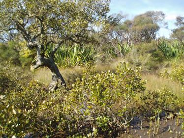
Estuarine Vegetation Survey - Whitianga Harbour

Report prepared for:

Catherine Beard
Resource Information Group
Environment Waikato
PO Box 4010
HAMILTON EAST

Report prepared by:

Meg Graeme M.Sc (Marine Science)
Natural Solutions – Marine and Terrestrial Ecologists Ltd
RD 2
COROMANDEL 3582
Ph: (07) 866 0770
Email: natural.solutions@wave.co.nz

Report submitted:

20th June 2009

Reference:

Natural Solutions Contract Report 09/085

Acknowledgements:
Natural Solutions would like to acknowledge the advice and support
received for this project from the following people and organisations:
Robert Kuchlein for support in the field; Catherine Beard, Jane Davidson
and Mark Williams from Environment Waikato for technical support.

                                                                            i
Whitianga Harbour estuarine vegetation survey, June 2009    NATURAL SOLUTIONS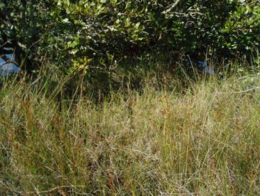
CONTENTS

1. Introduction .....................................................................................1

2. Methodology...................................................................................1

  2.1      Wetland vegetation classification .......................................... 2

3. Field Notes .......................................................................................1

  3.1      Summary...................................................................................... 1

  3.2      Site descriptions.......................................................................... 5

  3.3      Threats........................................................................................ 74

  3.4      Birds ............................................................................................ 76

4. Discussion and Recommendations ............................................77

5. Bibliography ..................................................................................79

Appendix 1: GPS locations of figures................................................81

                                                                                                              i
Whitianga Harbour estuarine vegetation survey, June 2009                             NATURAL SOLUTIONS
1.       Introduction
A 1997 pilot study of Whangamata, Wharekawa, and Otahu estuaries
determined that it is feasible to map vascular estuarine vegetation from
aerial photography together with field surveys. The success of this work
encouraged Environment Waikato to continue with this method. The
estuarine vegetation of Tairua, Coromandel, Te Kouma, Manaia, Whitianga
Port Waikato, Raglan, Aotea, Kawhia harbours and the inner Firth of Thames
have since been surveyed and mapped. Of these surveyed harbours,
Whangamata, Otahu, Wharekawa, Tairua and Manaia have been re-
surveyed to determine changes in vegetation communities over time.

The mapped vegetation is within the Coastal Marine Area (CMA) and
includes the spatial cover of mangrove, seagrass, sea meadow and
saltmarsh communities. The results of the estuarine surveys are included in
Environment Waikato’s Global Information System (GIS) database, and are
used for State of the Environment investigations and assessing consent
applications that may affect estuarine vegetation.

The estuarine vegetation of Whitianga Harbour was first mapped in 1999.
This report details the results from a re-survey of estuarine vegetation in the
Whitianga Harbour. Comments are included on the threats to estuarine
vegetation, and other field notes of interest. This report is accompanied by
digitised aerial maps of the survey site with vegetation community overlays.

2.       Methodology
The field survey was undertaken over 14 days between the 24th September
2008 and the 23rd March 2009. The survey was undertaken using a
combination of boating and walking. The same methodology for mapping
saltmarsh, mangrove, seagrass and weed communities was followed as
that previously used to map Coromandel Peninsula estuaries (e.g. see
Graeme, 1999), except that a personal digital assistant (PDA) loaded with
2006 aerial photographs of the survey site was used as the primary mapping
device. The PDA replaced the use of colour pen notations on hard copy
aerial photographs, although hard copy aerials were used as a backup for
when the PDA battery ran out, or sun lighting made it too difficult to see the
PDA screen clearly in the field. Coded polygons were drawn directly onto
the PDA aerial photographs to define the spatial extent of wetland
vegetation types as they were ground-truthed in the field.

The upper saltwater influence is usually indicated by the upstream limit of
oioi, saltwater paspalum or saltmarsh ribbonwood.

                                                                                  1
Whitianga Harbour estuarine vegetation survey, June 2009.     NATURAL SOLUTIONS
Field notes were made of estuarine wetland characteristics and their
vulnerability to particular threats.
2.1 Wetland vegetation classification
Estuarine wetland vegetation of the Waikato Region is split into four groups:
1. Saltmarsh – a multi-species community in which three sub-communities
are distinguishable in the Waikato Region. They are:
a) ‘Rush/sedge community’ – This is generally sea rush (Juncus kraussii
var. australiensis), oioi (Apodasmia similis), and on the West Coast,
three-square sedge (Schoenoplectus pungens). Marsh clubrush
(Bolboschoenus fluviatilis) is commonly found up streams and rivers at
the upper estuarine limit in some harbours, although it is not mapped
within this survey as it is a species of brackish freshwater.
b) ‘Saltmarsh ribbonwood community’ – Saltmarsh ribbonwood
(Plagianthus divaricatus) dominates this zone, although rushes are
also common giving a patchy appearance compared with the
uniformity of the ‘rush/sedge community’. Small areas of sea
primrose (Samolus repens), remuremu (Selliera radicans), the coast
spear grass (Austrostipa stipoides), and glasswort (Sarcocornia
quinqueflora) can also be present.
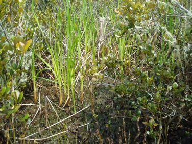
c) ‘Sea meadow community’ – This is devoid of tall plants such as rushes
and saltmarsh ribbonwood, with the exception of coast spear grass.
The sea meadow community can include sea primrose, remuremu,
glasswort, , slender clubrush (Isolepis cernua), and arrow grass
(Triglochin striata),.and in more brackish areas bachelor’s button
(Cotula coronopifolia), leptinella (Leptinella doica) and sharp spike-
sedge (Eleocharis acuta)
2. Mangrove (Avicennia marina subsp. australasica) – This is usually a
monospecific community although seagrass, sea meadow, spartina
(Spartina spp). and saltwater paspalum (Paspalum vaginatum) beds
can sometimes be found underneath mature mangrove stands.
3. Seagrass (Zostera capricorni) – This is usually a monospecific community,
and is the vegetation which occurs at the lowest level in the tide.
4. ‘Weed community’ – In the Waikato Region the most significant estuarine
weeds are saltwater paspalum and spartina. Both of these grasses
generally grow in the open estuary and trap sediment, greatly
increasing the harbour’s infilling rate. These weeds also compete with
the native wetland communities.
There are other weed species (such as tall fescue (Schedonorus
phoenix)) which can tolerate a degree of salt influence but for clarity of
2
Whitianga Harbour estuarine vegetation survey, June 2009. NATURAL SOLUTIONS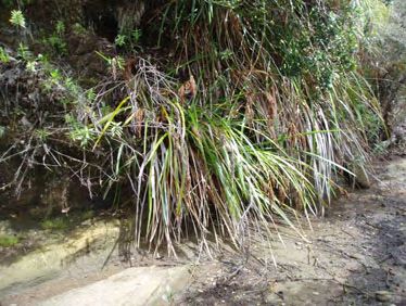
mapping they have not been included in the surveys due to their
   presence above the spring high tide mark.

For the purpose of mapping, additional vegetation categories have also
been added to more accurately portray the increasing prevalence of
‘mixed’ short-stature communities. Saltwater paspalum in particular is
spreading and mixing with rush/sedge, sea meadow and saltmarsh
ribbonwood communities. Where two differently layers co-exist (e.g.
seagrass or saltwater paspalum under mangroves) these are mapped as
individual layers.

                                                                           3
Whitianga Harbour estuarine vegetation survey, June 2009.   NATURAL SOLUTIONS
3. Field Notes
3.1 Summary
The following observations provide a general overview of estuarine
vegetation in the Whitianga Harbour following the field visit.
• There is a lack of large seagrass beds in the harbour.
• Extensive mangals (mangrove forests) dominate the central islands
and along the middle and upper harbour edges.
• Mangroves range in height from 6-8m, with the occasional tree
estimated at 9m or more in height.
• Wide beds of sea rush and oioi dominate behind the mangroves in
the sheltered upper embayments and river arms.
• Relatively large areas of saltmarsh ribbonwood occur along the
landward edge of estuarine wetland communities, particularly up
the Whenuakite River.
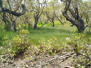
• In a few areas unaffected by farming, the saltmarsh ribbonwood
zone grades into freshwater swamp communities characterised by
swamp coprosma (Coprosma propinqua), manuka (Leptospermum
scoparium), pohuehue (Muehlenbeckia complexa), coastal shrub
daisy (Olearia solandri), blue-green sedge (Baumea juncea), tall
fescue and pampas (Cortaderia selloana).
• Sea meadow communities of notable size are found along river
outwash edges; in patches amongst rush/sedgeland or between
mangals and rush/sedgeland; and on shell banks. Sea meadow
species present include glasswort, sea primrose, remuremu, coast
spear grass.
• Only one patch of spartina was found, at the mouth of Owhero
Creek.
• Saltwater paspalum is common around the harbour, particularly
along river margins and between the mangrove and rush/sedge
communities such as on the true left bank of the Waipakupaku
Creek.
• Saltwater paspalum occurs either as dense monospecific mats or
mixed with sea meadow, rush/sedge, mangrove or saltmarsh
ribbonwood communities. Saltwater paspalum was also noted
mixed with the landward edge of seagrass beds.
• The steeper margins of the harbour are predominantly covered in
regenerating native bush. In contrast, the flatter areas (e.g. around
Whitianga township) are highly developed either as urban
development or for agriculture.
1
Whitianga Harbour estuarine vegetation survey, June 2009. NATURAL SOLUTIONS• Stock access into the CMA is an issue along the true right banks of
the Whenuakite River, the true right bank of the Ounuora River (Mill
Creek) downstream of the state highway bridge and the true left
bank of the Whangamaroro River.
• Many of the stream banks above the CMA are not adequately
fenced to restrict farm pollution entering the waterways and
harbour.
Table 1 lists common estuarine plant species found during the surveys. The
‘estuarine vegetation community’ category for the estuarine species
corresponds to the vegetation boundaries digitised on the aerial maps.
See Figure 1 for a map showing the site names and figure numbers
mentioned below. A table of GPS points of the figure locations is in
Appendix 1.
Table 1: Check list of common estuarine plant species found in Whitianga
Harbour.
Common/Maori Scientific name Estuarine
name Vegetation
Community
arrow grass Triglochin striata sea meadow
coast spear grass Austrostipa stipoides sea meadow
glasswort Sarcocornia quinqueflora sea meadow
mangrove Avicennia marina subsp. mangrove
australasica
oioi Apodasmia similis rush/sedge
remuremu Selliera radicans sea meadow
saltmarsh Plagianthus divaricatus saltmarsh
ribbonwood ribbonwood
saltwater paspalum * Paspalum vaginatum weed
sea primrose Samolus repens sea meadow
sea rush Juncus krausii var. australiensis rush/sedge
seagrass Zostera capricorni seagrass
2
Whitianga Harbour estuarine vegetation survey, June 2009. NATURAL SOLUTIONSslender clubrush Isolepis cernua sea meadow
spartina/cord grass * Spartina spp. weed
* denotes an exotic species
3
Whitianga Harbour estuarine vegetation survey, June 2009. NATURAL SOLUTIONSNgarahutunoa Stream
Weiti
Whangamaroro
Te Ana
Kopaki Pt
Owhero Creek
Kohuamuri Stream
Ounuora River
Kaitoki Stream
Waipapa Creek
Waipakupaku
Whenuakite River
Waiwawa River
Figure 1: Whitianga Harbour site localities mentioned in this report. The
numbers refer to the location of the following figures.
4
Whitianga Harbour estuarine vegetation survey, June 2009. NATURAL SOLUTIONSSite descriptions
Whitianga Harbour is described clockwise from the harbour mouth. See
Figure 1 for a map showing the site names and figure numbers mentioned
below. True left bank (TLB) and true right bank (TRB) refer to the side of a
river when facing downstream.
Isolated mangroves and the odd scattered rush patch occur in the outer
embayments near the harbour mouth (Figure 2). The brown seaweed
Neptune’s necklace (Hormosira banksi) is common on rocky platforms
along the intertidal coastal edge. The first significant mangrove fringe does
not occur until the bay north of Red Hill (Figure 3). Behind the mangroves
and narrow rush/sedge band is a freshwater wetland with manuka, flax,
Coprosma propinqua x robusta, coastal shrub daisy and willow (Salix sp.).
Regenerating coastal forest (including pohutukawa, coastal five finger,
kanuka, pines, Pittosporum umbellatum and ngaio, red matipo, wattle
species covers most of the landward edge along this side of the harbour up
to the first ridgeline (Figure 4).
The rush/sedge fringe which lines the freshwater wetlands along this north-
eastern harbour edge is undermined by wave action in many places where
there isn’t a seaward protective zone of mangroves (Figure 5).
A dense and wide mangal has formed between the saltmarsh and oyster
farm structures in the embayment between Red Hill and Kopaki Point.
Some seagrass is found beneath taller mangroves along the northern edge
here. Mangroves become stunted along the landward edge where they
blend with the wide saltmarsh zone. A large raupo/Baumea
juncea/manuka swamp is found in behind the saltmarsh. Banded rail were
heard and seen in this area.
Sand/shell ridges (chenier ridges) along the front edge of the mangal have
saltwater paspalum, glasswort, sea primrose, saltmarsh ribbonwood, sea
rush and coastal spear grass growing on them.
The large islands within the mid-harbour are covered with mangroves that
have established in the lee of the chenier ridges. These chenier ridges
support rush/sedgeland, sea meadow species, saltwater paspalum,
saltmarsh ribbonwood, shore bind weed, knobby clubrush (Ficinia nodosa)
(see Figures 6-8) and some coastal forest species such as ngaio,
pohutukawa, flax and manuka. Red matipo, akeake, Coprosma
propinqua, C. propinqua x robusta, flax, bracken, pampas, phoenix palm,
coastal five finger, wattle species, coastal shrub daisy, and five-finger
(Pseudopanax lessonii). A population of Tamarisk salt cedar (Tamarix sp.)
has established on the larger mangrove island (Figure 9).
5
Whitianga Harbour estuarine vegetation survey, June 2009. NATURAL SOLUTIONSBanded rail and pig footprints were seen out on the larger of the harbour
islands. Little black shags were observed around Kopaki Point.
Some of the large mangroves immediately east of Kopaki Point have fallen
over and there is a notable lack of replacement juveniles. The intertidal
flats along the Kohuamuri Stream channel are thigh-deep mud seaward of
the mangrove fringe. The substrate beneath the mangroves is more firm
and there are a lot of pneumatophores, crab holes and scattered titiko.
The mangrove canopy here is 7-8m tall along the cliff side of the channel
(Figure 10). There are also young mangrove seedlings along the landward
edge and in light wells where old trees have fallen over. Flying insects were
common under the mangrove canopy.
Figure 11 shows a mangrove-lined side creek that enters the Kohuamuri
Stream channel. Sheep were seen at the head of this bay (Figure 12) as
well as banded rail footprints. Here, Baumea juncea was mixed with oioi,
sea rush, as well as amongst mangroves.
Moving past this small side arm, the rush/sedge community behind the
mangroves it is relatively narrow. Saltmarsh ribbonwood is uncommon and
the rush/sedgeland generally grades into manuka and regenerating
coastal forest (Figure 13). A pig wallow and tracks were found in the
rush/sedgeland. Patches of seagrass often occur under tall mangrove
canopy, and usually towards the landward side of the mangal. While
possum control has been undertaken around Kopaki Point, further up
towards Kohuamuri Stream possum browse was notable on the
pohutukawa and also mangroves where there is dry access to trees from
the land (Figure 14). At the mouth of the Kohuamuri Stream is a whitebait
stand and large maimai hut. Banded rail were heard here.
South of Kohuamuri Stream, pig tracks and droppings were common
through the rush/sedgeland (Figure 15). Figure 16 shows an extra tall
mangrove alongside the Kaitoki Stream channel with stunted mangroves
on a rocky base in the foreground. The rush/sedgeland band behind the
mangal widens south of Kaitoki Stream mouth (Figure 17). Some earthworks
in the CMA has occurred near the mouth of the Kaitoki Stream (Figure 18).
Below Kaitoki Point the rush/sedgeland zone is very wide and blends with
tall mangroves along the landward fringe of the mangal (Figure 19). Large
patches of slender clubrush, arrow grass and sea primrose also occur here
(Figure 19 and 21), and banded rail and pukeko footprints were common.
Figure 20 shows tidal pools alongside the mangrove-rush/sedge boundary
which had thousands of juvenile fish in them. Note that the manuka
wetland fringe here was incorrectly mapped as ‘saltmarsh ribbonwood
community in the 1999 survey. Saltmarsh ribbonwood is only present in
narrow scattered patches along the edge. A few patchy areas of sea rush
were found that contained small clumps and dead bases in between larger
clumps (Figure 22). Figure 23 shows rushland with a distinct boundary
6
Whitianga Harbour estuarine vegetation survey, June 2009. NATURAL SOLUTIONSbetween two areas of different height sea rush. Smaller isolated patches of
rush/sedgeland are separated by mangroves from the main
rush/sedgeland band. Sea rush is generally the only or dominate species
here. Oioi is more common in the wide landward rush/sedge band. The
two terrestrial islands provide some floral diversity amongst the mangroves
(Figure 24). The rush/sedgeland band is still very wide from Kaitoki Point
around to the mouth of the Whenuakite and Waiwawa River channels
(Figure 25). Fernbird are common in this area. Figure 26 shows a large
dense patch of Baumea juncea with sea rush and oioi landward.
Towards the mouths of Whenuakite and Waiwawa Rivers, there are islands
and sand bars with saltmarsh ribbonwood, Coprosma propinqua, C.
propinqua x robusta, coastal shrub daisy, ngaio and manuka (Figure 27).
Small pioneer patches of saltwater paspalum occur along the mangrove-
rush/sedge boundary, often invading sea meadow patches. Out on the
sand bar lining the TRB of the river channel, saltwater paspalum becomes
dominant (Figure 28). Back under the pure mangrove canopy there are
lots of small titiko. Large logs have washed up on the open intertidal flats of
the river channel and these provide popular bird roosts particularly for pied
stilt (Figure 29).
Around from Kaitoki Point and upriver past the bluffs is a small mangrove
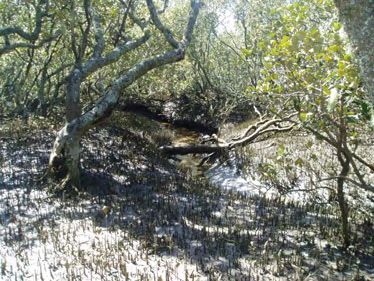
island at the mouth of the Whenuakite River. Over on the TRB seagrass is
common behind and under the mangroves (Figures 30-32). There was
some sign of grazing on mangroves, and animal tracks and camps (goats
or sheep) were found on higher ground. The mangrove canopy was about
5m tall here but the tallest mangroves were up to 8m.
Travelling up the TRB of the Whenuakite River - pugged, tracked and grazed
vegetation is common where unfenced farmland adjoins the harbour
margin (Figure 33-35). Stock grazing is also hindering forest regeneration on
the harbour edge. Figure 36 shows a stream where the rush/sedgeland on
one side is clearly damaged by stock and the other side isn’t. Seaward of
the wide rush/sedgeland is a mangrove fringe with an understorey of dense
saltwater paspalum (Figure 37). Banded rail were heard here. An area of
dead saltwater paspalum was found amongst rush/sedgeland away from
the mangrove canopy (Figure 38). The reason why the saltwater paspalum
has died is unclear but assumed to be the result of a severe frost coinciding
with a low early morning tide. Arrow grass was found alive amongst the
dead saltwater paspalum (Figure 39) and saltwater paspalum was healthy
under the shelter of mangroves (Figure 40).
Further up the Whenuakite River on the TRB the inland extent of the estuarine
to freshwater vegetation sequence is un-naturally truncated over the
floodplain due to land drainage for agriculture (Figure 41). Large areas of
saltmarsh ribbonwood occur around the Te Kauanga Rd bridge (Figures 42
and 43) and fernbird were heard. Pukeko and swallows are also common
here. The estuarine influence is reduced to the immediate stream edge
7
Whitianga Harbour estuarine vegetation survey, June 2009. NATURAL SOLUTIONSupstream of the bridge, and estuarine vegetation completely disappears
about 1.5km upstream of the bridge. Freshwater wetland continues as the
predominant streamside vegetation upstream except where land drainage
and stop-banking has occurred, as is the case along the upper reaches of
the TLB (Figure 44).
Downstream of the Te Kauanga Rd bridge on the TLB the estuarine
vegetation zone widens but is still constrained inland by stopbanks (Figure
45). Large areas of saltmarsh ribbonwood occur in behind the
rush/sedgeland and lining waterways (Figure 46). The upstream limit of
mangroves is about 0.5km downstream of the bridge. Mangroves then
dominate along the river banks and side creeks (Figure 47) further
downstream. Sea rush and saltwater paspalum are common along the
river edge under the mangrove canopy (Figure 48). Scattered small
patches of sea meadow (arrow grass and sea primrose) are common too.
Saltwater paspalum becomes the dominant mangrove understorey
towards the junction of the Whenuakite and Waiwawa Rivers (Figure 49).
Fantails were common in the mangal chasing insects.
At the mouth of the Waiwawa River, on the TRB, patches of dead saltwater
paspalum were present (Figures 50-52). Many banded rail footprints were
seen and fernbird heard. The natural inland extent of estuarine vegetation
is truncated by stopbanks. The remaining estuarine vegetation upstream is
limited to the immediate stream side (Figures 53 and 54) and a disturbed
wider estuarine flat on the inside of the river bend (Figures 55 and 56). The
inside river bend wetland is not fenced from stock access. Tall fescue is
present on pugged higher ground. Fernbird, pied stilt and a bittern were
present in this area. Oioi marked the upper extent of estuarine vegetation
on the TRB of the river.
Moving downstream along the TLB of the Waiwawa River, the bank sides
are much eroded, and attempts have been made to protect the banks
with concrete debris. Dead saltwater paspalum was found on the TLB of the
river mouth (presumably again from frost). Banded rail were present here.
Some good pampas and wattle control has been undertaken in the area,
however stock access into the CMA is a problem from along the stopbank
and a track out to the river mouth (Figures 57 and 58). Around the corner of
the river mouth there is a good diversity of native vegetation along the
harbour edge and on raised islands within the saltmarsh. Species noted
include Coprosma propinqua, manuka, fernbird, coastal shrub daisy,
Baumea juncea, red matipo, flax, Coprosma tenuicaulis, kanuka, ngaio,
silver fern, totara, tanekaha (Figure 59). This area has been heavily tracked
by stock. There were banded rail foot prints present.
Large expanses of rush/sedgeland occur in behind the mangroves that line
the Whenuakite/Waiwawa river edge (Figure 60). Fernbird were heard in
the rush/sedgeland. The distribution of mangrove and rush/sedgeland
8
Whitianga Harbour estuarine vegetation survey, June 2009. NATURAL SOLUTIONScommunities is affected by drainage systems that cut through the estuarine
vegetation.
Towards the Waipakupaku Creek embayment, the stopbank dramatically
narrows the functioning estuarine edge. Sea primrose and saltwater
paspalum patches are scattered under a ~3m high canopy of mangroves
(with some taller trees) (Figure 61). A dead cow and sheep were found out
amongst the mangroves. The river banks are steep and eroded with many
crab holes. Earthworks have been recently been undertaken out on the
point (Figure 62). Banded rail are in the area.
The outer exposed edge of mangroves at the southern mouth of the
Waipakupaku Creek embayment have ‘prop’ roots along their lower
branches. Seagrass below the mangroves varies from dense beds to
scattered patches around Waipakupaku Creek arm. Pampas and wattle
are a problem along the land edge. Rubbish and spoil has been dumped
along the estuarine edge further into the embayment and stock damage
to estuarine soils and vegetation is an issue (Figures 63-65). Signs of
machinery operating in the saltmarsh were also apparent.
Floodgates and stopbanks form a boundary between the estuarine
vegetation and freshwater vegetation at the head of the Waipakupaku
Creek embayment (Figure 66). Along the TLB, between the rush/sedgeland
community and the mangal, is a large expanse of saltwater paspalum.
Much of this infestation has died off recently (Figures 67-71), again
presumably because of a severe frost. A seed head found on dead
saltwater paspalum (in early October 2008) indicated it may have died
during the 2008 winter, although it is expected that it will grow back from
underneath. Fernbird and bittern are present in the area. Sea meadow is
common at the rush/sedge and mangrove interface (where it is not
smothered by saltwater paspalum) (Figure 72). Patches of sea rush (and
saltwater paspalum) extend seaward into the mangal. The thick landward
saltmarsh band is characterised by oioi. Freshwater manuka/Baumea
juncea wetland is common behind the estuarine vegetation before the
land rises steeply. Much of this harbour edge is covered in early
regenerating coastal forest but with wilding pines and wattle often present
(Figures 72 and 73). Housing associated with lifestyle blocks have extended
into the area.
A patch of young mangroves is establishing out from the main mangal
lining Ounuora River and Waipapa Creek mouths (Figure 74). Banded rail
footprints were seen amongst mangroves at the Waipapa Creek river
mouth. Saltwater paspalum is common along the creek banks. Oioi and
sea rush are generally the only community between the mangroves and
steep land edge except at the head of the arm where saltmarsh
ribbonwood dominates along the stream and causeway edges (Figure 75).
The causeway forms a boundary between the saltwater and freshwater
wetland communities up the Waipapa Creek.
9
Whitianga Harbour estuarine vegetation survey, June 2009. NATURAL SOLUTIONSStock are not fenced out of the CMA on the lower TRB of Ounuora River
(Mill Creek) and have been grazing and pugging the narrow band of
mangroves, saltmarsh ribbonwood, sea rush and saltwater paspalum
(Figure 76). A wide band of rush/sedgeland extends out from the TLB of the
Ounuora River mouth to a long narrow coastal scrub island bar. The inland
estuarine boundary is defined by a stopbank but this is breached at its
northern end. Some of the mangroves between Ounuora River and
Owhero Creek are up to 9m high.
Around into the Owhero Creek embayment there is a large patch of
rush/sedgeland enclosed on the seaward side by mangroves, but then the
mangroves extend towards the land edge with a sporadic narrow band of
rush/sedge. Areas of flat bedrock are often exposed or very near the
surface along the landward edge of the TRB. A number of exposed
bedrock areas had seagrass growing in muddy hollows and cracks. A
patch of short-statured spartina occurs near where the highway comes
close to the estuary arm (Figure 77). The head of the arm grades into
freshwater wetland communities and then farmland. Downstream on the
TLB is a large rush/sedge band with a manuka/Gleichenia wetland behind.
Fernbird were heard in this area. A small rocky outcrop is surrounded by
rush and mangrove with a few saltmarsh ribbonwood, coast spear grass
and glasswort on higher ground.
Lush seagrass and sea primrose beds are present in the back of a small
mangrove embayment to the north of Owhero Creek mouth (Figure 78).
The embayment is surrounded by bluffs and advanced regenerating bush.
A thin band of mangrove and saltwater paspalum are found along the next
shallow embayment (Figure 79-80). There is no estuarine vegetation until
past the next headland where mangroves begin to thicken towards Te Ana
Point and there are pockets of saltmarsh ribbonwood with freshwater
wetland behind (Figure 81). An area of ‘yellowing’ flax was noted here.
There was a small area of cleared mangroves, presumably cleared to
provide an open water view from the nearby house. Sparse seagrass beds
were present behind the mangroves or under younger mangroves
establishing in the back. Saltwater paspalum extends down into the
seagrass zone (Figure 82). Generally there is very little saltmarsh present as
the mangroves grow right up to the freshwater wetland edge of tangle fern
(Gleichenia sp.) and Baumea juncea (Figure 83). Fernbird were present
here.
Low (but old) mangroves occur on the exposed western side of the small
mangrove island near Te Ana Point (Figure 84). The rest of the island
supports much taller well-rooted mangroves.
Around Te Ana Point, the mangroves generally extend up to the land edge
with little or no rush/sedgeland in-between (Figure 85). Healthy dense
seagrass beds of varying widths extending out from the land edge under
10
Whitianga Harbour estuarine vegetation survey, June 2009. NATURAL SOLUTIONSthe mangrove canopy (Figure 86). Also of note was the presence of
Machaerina sinclarii along the harbour edge immediately south-west of Te
Ana Pt (Figure 87). Further up the TRB of the Whangamaroro River, is an
embayment bound by stopbanks. There are more healthy dense seagrass
beds here under 0.5-5m tall mangroves. There are quite distinct plant
height zones but the canopy height didn’t seem to affect whether seagrass
was present or not (this may be related to water depth and flow).
Scattered patches of sea primrose, saltwater paspalum and sea rush occur
below the mangrove. A dredged channel with a ramp allows cattle into
the CMA (Figure 88). Further along, farming rubbish has been dumped in
the CMA (Figure 89). Saltwater paspalum becomes more prevalent further
upstream mixing with sea rush, oioi, saltmarsh ribbonwood and mangrove
(Figure 90). Many of the tall mangroves along the rush/saltwater paspalum
zone are dying, but the cause is unclear. Fernbird were heard in the
saltmarsh ribbonwood here. Figure 91 shows an area where saltwater
paspalum is not present (uncommon in this area) amongst the estuarine
vegetation communities. The upstream limit of estuarine vegetation is
indicted by thin patches of oioi and saltwater paspalum (Figure 92).
Downstream on the TLB of the Whangamaroro River is a roost and a possible
breeding site for pied stilts (Figure 93). Saltwater paspalum is prevalent here.
Some of the old isolated mangroves are up to 9m high along the landward
mangal fringe (Figure 94). Small scale infilling of the saltmarsh is still
occurring along the farmland edge.
An extensive area of rush/sedgeland occurs towards the TRB of the Weiti
Stream. This has some open patches, particularly towards the mangrove
zone, where unvegetated mud or a combination of saltwater paspalum
and arrow grass are common (Figure 95).
At the Weiti Stream mouth, the outflow debris has been mechanically
spread and pushed into saltmarsh and mangroves. This disturbance is
encouraging the spread of weeds. Tall fescue and bachelors button are
common on the disturbed sandy silt outwash soils. Wattle is very common
along disturbed higher ground such as stopbanks. On the TLB of the Weiti
Stream there is a saltmarsh ribbonwood band backing the saltmarsh (Figure
96). This grades into a manuka forest which has a thick understorey of the
introduced weed montbrettia (Crocosmia x crocosmifolia). Stock access
is an issue here. Stock tracks are found along the top of the stopbank, with
side tracks leading down to the saltmarsh. Carpets of arrow grass are
common under the landward patchy mangrove edge. Copper butterflies
were seen in saltmarsh ribbonwood and tall fescue. The inland extent of
the estuarine vegetation is truncated by stopbanks from the Weiti Stream to
Ngarahutunoa Stream. Further up the Ngarahutunoa Stream, State
Highway 25 crosses the estuary. Pampas is common alongside the
drainage channels from the golf course. Recent earthworks along the golf
course land has encroached into highly significant freshwater wetland
vegetation (Figure 97). This threatened habitat type is characterised by
11
Whitianga Harbour estuarine vegetation survey, June 2009. NATURAL SOLUTIONSBaumea juncea, Coprosma propinqua and Coprosma propinqua x
robusta, manuka, flax; and is critical habitat for fernbird.
Industrial land has infilled the harbour edge along Moewai Park Rd. Cat
prints were found in the mangroves near the Whitianga rubbish dump
(Figure 98). The old dump site is poorly contained with rubbish spilling out
into the CMA. Glass, plastic, cans, metal etc. were found among the
saltwater paspalum, oioi and mangroves making walking in the area quite
dangerous (Figure 99). Banded rail footprints were present in an open area
of young sea rush and saltwater paspalum (Figure 100). Further
downstream past the industrial zone, infilling has not been as extensive and
there is a wide rush/sedgeland zone (Figure 101). A thin band of saltmarsh
ribbonwood and manuka screen the urban development along Moewai
Park Rd and adds to the high natural character of the area. Patches of
arrow grass and sea primrose occur under mangrove. Seagrass patches
are also found along the landward edge of the mangroves and in open
areas within the mangal. In a few places the estuarine and freshwater
communities are mixed. Figure 102 shows Baumea juncea and raupo
amongst short 1-1.5m tall mangroves, with a wide oioi zone landward.
Many walkways (raised boardwalk, concrete etc) were found through the
mangroves along the eastern end of the wide rush/sedgeland with varying
impacts on the native vegetation (Figure 103). Infilling of the esplanade
reserve (and mangrove clearance) is of particular concern near the
junction with Hei Esplanade (Figure 104). Along the front of Hei Esplanade,
there is a thin band of rush/sedgeland and saltmarsh ribbonwood (with
saltwater paspalum mixed through) behind the mangroves with a planted
coastal forest edge (Figure 105).
A reef heron was observed with pied shags and mallard ducks at the
entrance of the Waterways canal development (Figure 106). On the TLB of
the canal entrance is the last of the tall mangal along this edge (Figure
107). Trees within the south-eastern portion of the mangal have been
poisoned (Figures 108-111). Saltwater paspalum is present along the canal
edge with sea primrose and a small amount of glasswort. Sea rush, oioi and
saltmarsh ribbonwood are present in behind the mangroves. Builders’
rubbish (plastic and polystyrene) has washed into the mangroves.
East of the Waterways canal entrance, a small natural creek runs inland to
the old South Highway 25 road. Mangroves dominate the lower half of this
creek and patches of sea rush, oioi and three square occur along the
upper reaches before the road culverts. A few old pohutukawa and
macrocarpa provide some canopy shade along the creek edge.
Small patches of sparse seagrass occur along the intertidal flats towards the
Robinson Road boat ramp. There are small groups of tall mangroves but a
lack of mangrove seedlings. A couple of large mangroves have been cut
down near the boat ramp.
12
Whitianga Harbour estuarine vegetation survey, June 2009. NATURAL SOLUTIONSThe land edge between the canal entrance and the boat ramp is very
weedy with lots of garden escapees dominating (including agapanthus,
nasturtium, honeysuckle and wandering willy).
Garden waste is also dumped along the harbour edge towards Whitianga
township (Figure 112). The coastal edge becomes more armoured towards
the township and harbour mouth (Figure 113). Saltwater paspalum and the
occasional patch of sea meadow are found where sand has built up
beside the seawall coast line. Saltwater paspalum and the occasional
mangrove have also established up the watercourse running alongside the
reserve land of Taylors Mistake. Saltwater paspalum blends with open coast
plants such as knobby clubrush and spinifex out at the harbour entrance.
13
Whitianga Harbour estuarine vegetation survey, June 2009. NATURAL SOLUTIONSFigure 2: A few isolated mangroves are the only vascular estuarine
vegetation in the bay south of Back Bay.
Figure 3: The second bay south of Back Bay (and opposite the marina) has
the first major band of mangroves. Neptunes necklace (Hormosira banksii)
seaweed is common on the hard intertidal flats. Silty sand dominates
further into the bay.
14
Whitianga Harbour estuarine vegetation survey, June 2009. NATURAL SOLUTIONSFigure 4: The view looking NE into the bay shown in Figure 3. Manuka, flax, Coprosma propinqua x robusta, coastal shrub
daisy and willow occur in the freshwater wetland behind the mangroves at the right hand end of bay.
15
Whitianga Harbour estuarine vegetation survey, June 2009. NATURAL SOLUTIONSFigure 5: The third bay south of Back Bay has a perched freshwater swamp
with tangle fern (Gleichenia dicarpa), Baumea juncea, manuka and raupo
in behind the eroded thin sea rush edge. Behind the wattle and buffalo
grass edge to the north (left) is an oioi sedgeland with a patch of saltmarsh
ribbonwood.
Figure 6: Mangroves on an island in the middle of the harbour surround a
sand bar carpeted with sea primrose and saltmarsh ribbonwood.
16
Whitianga Harbour estuarine vegetation survey, June 2009. NATURAL SOLUTIONSFigure 7: The eroded edge of the central harbour island. Akeake, oioi,
glasswort, saltmarsh ribbonwood and mangroves occur here. Old
mangrove stumps are in the foreground.
Figure 8: A distinct boundary between the glasswort (darker green) and
saltwater paspalum (light green) communities on this island sand bar.
17
Whitianga Harbour estuarine vegetation survey, June 2009. NATURAL SOLUTIONSFigure 9: Pink flowered Tamarix sp. bush growing on a chenier ridge of the
large mangrove island.
Figure 10: A view through an open tall mangal on the TRB of the Kaitoki
channel. The mangrove canopy is around 8m tall here.
18
Whitianga Harbour estuarine vegetation survey, June 2009. NATURAL SOLUTIONSFigure 11: A mangrove-lined creek that enters the Kohuamuri Stream
channel with Entromorpha (a brown filamentous algae) on the mud flats in
places.
Figure 12: The head of this embayment (on the TRB of the Kohuamuri Stream
arm) contains oioi, live and dead mangroves, sea rush, arrow grass and
slender clubrush, Isolepis prolifera, a Carex sp. and manuka. Stock pugging
was throughout and sheep were seen grazing on grass behind these
mangroves.
19
Whitianga Harbour estuarine vegetation survey, June 2009. NATURAL SOLUTIONSFigure 13: Here along the TRB of the Kohuamuri Stream arm there is very
little saltmarsh ribbonwood and mangrove, and the oioi and sea rush
change abruptly into a manuka edge.
Figure 14: Possum browse on a large mangrove abutting a pohutukawa
forest.
20
Whitianga Harbour estuarine vegetation survey, June 2009. NATURAL SOLUTIONSFigure 15: Pig tracks criss-cross through the saltmarsh south-west of the
Kohuamuri Stream.
Figure 16: A tall (> 9m) mangrove in the distance stands out above the
main mangal canopy along the edge of the Kaitoki Stream (visible in the
middle background). An old farm fence is found out near the mangroves.
21
Whitianga Harbour estuarine vegetation survey, June 2009. NATURAL SOLUTIONSFigure 17: Large mangroves are surrounded by oioi sedgeland. Wattle is a
weed along the coastal forest edge. Fernbird were present here.
Figure 18: This photo shows an excavated channel (for duckshooting?)
diverging from the Kaitoki stream mouth. The natural channel continues
upstream to right beside the mangroves.
22
Whitianga Harbour estuarine vegetation survey, June 2009. NATURAL SOLUTIONSFigure 19: A view over saltmarsh showing sea rush landward with patches of oioi seaward and intermixed with the mangrove
fringe. Arrow grass (light green) is common within open mud patches. Banded rail and pukeko were noted here.
23
Whitianga Harbour estuarine vegetation survey, June 2009 NATURAL SOLUTIONSFigure 20: Many juvenile fish were seen in standing tidal pools between
rushes and mangroves such as this.
Figure 21: Sea primrose dominates open mudflats together with scattered
mangroves and clumps of searush (light brown in background).
24
Whitianga Harbour estuarine vegetation survey, June 2009. NATURAL SOLUTIONSFigure 22: A patchy sea rush community with small clumps and dead bases
inbetween larger clumps.
Figure 23: A distinct boundary between a patch of much taller sea rush
and shorter plants in the foreground.
25
Whitianga Harbour estuarine vegetation survey, June 2009. NATURAL SOLUTIONSFigure 24: Vegetation noted on this small island within a mangal includes
flax, manuka, coastal shrub daisy and mingimingi. Banded rail were present
here.
Figure 25: A wide sea rush and oioi band landward of the mangrove fringe.
Note the line of old fence posts in the sea rush near the manuka scrub
edge abuts kanuka and pine. Fernbird are present here.
26
Whitianga Harbour estuarine vegetation survey, June 2009. NATURAL SOLUTIONSFigure 26: Patchy sea rush in the foreground with a large dense patch of
Baumea juncea in the mid-ground and sea rush and oioi landward. An old
fence line cuts across the mangrove/rush interface. Kaitoki Point is in the
background.
Figure 27: Raised sand islands support saltmarsh ribbonwood, Coprosma
propinqua, Coprosma propinqua x robusta, coastal shrub daisy, ngaio and
manuka.
27
Whitianga Harbour estuarine vegetation survey, June 2009. NATURAL SOLUTIONSFigure 28: Saltwater paspalum mixed with sea primrose and sea rush under
an open mangrove canopy.
Figure 29: About 50 pied stilts were seen roosting on large logs along the
river flats at high tide.
28
Whitianga Harbour estuarine vegetation survey, June 2009. NATURAL SOLUTIONSFigure 30: Mangroves abut steep land edges which often have a band of
deep mud at their base. Sea primrose is shown here (beside rock). Patches
of sea rush, oioi and some saltwater paspalum also occur here.
Figure 31: This photo shows dense seagrass under a mangrove canopy. A
lot of epiphytes grow on the mangrove trunks including various encrusting
and hanging lichens and moss.
29
Whitianga Harbour estuarine vegetation survey, June 2009. NATURAL SOLUTIONSFigure 32: A back-swamp zone with limited sea rush and oioi. Sea primrose,
arrow grass and seagrass form dense mats over very deep mud in between
land edge and mangroves.
Figure 33: This estuarine edge of slender clubrush, remuremu, sea rush and
oioi and Isolepis prolifera is pugged due to a lack of farm fencing. The
saltmarsh abuts a manuka edge.
30
Whitianga Harbour estuarine vegetation survey, June 2009. NATURAL SOLUTIONSFigure 34: Lack of fencing here has resulted in browsing of the estuarine
vegetation and a loss lack of regeneration of the native coastal forest
edge.
Figure 35: This saltmarsh zone is dominated by oioi, with Baumea juncea
along the inland manuka edge. Stock tracking, grazing and cow pats
occur through the saltmarsh. Scattered small patches of Isolepis prolifera,
remuremu and slender clubrush were found.
31
Whitianga Harbour estuarine vegetation survey, June 2009. NATURAL SOLUTIONSFigure 36: Stock have access to the sea rush and oioi in the foreground. In
comparison, the oioi is tall and dense on the opposite stream bank where
stock are excluded. Fernbird were present in the ribbonwood to the RHS.
Figure 37: Mangroves with an understorey of saltwater paspalum, oioi and
sea rush along the TRB of the lower Whenuakite River.
32
Whitianga Harbour estuarine vegetation survey, June 2009. NATURAL SOLUTIONSFigure 38: Dead saltwater paspalum occurs in sheltered open areas
amongst sea rush and oioi. Healthy arrow grass is common amongst the
saltwater paspalum.
Figure 39: A close up view showing live arrow grass (thin green leaves)
amongst dead saltwater paspalum.
33
Whitianga Harbour estuarine vegetation survey, June 2009. NATURAL SOLUTIONSFigure 40: Healthy saltwater paspalum under a mangrove canopy and
amongst sea rush and oioi.
Figure 41: In this photo the saltmarsh extends inland to a thin band of
manuka, coastal shrub daisy and flax bordering a straight farmland
boundary.
34
Whitianga Harbour estuarine vegetation survey, June 2009. NATURAL SOLUTIONSFigure 42: View downstream from Te Kauanga Rd bridge over
rush/sedgeland along the TRB of the river edge and saltmarsh ribbonwood
communities further inland.
Figure 43: View upstream from Te Kauanga Rd bridge over rush/sedgeland
along the TRB of the river edge and saltmarsh ribbonwood communities
further inland.
35
Whitianga Harbour estuarine vegetation survey, June 2009. NATURAL SOLUTIONSFigure 44: View upstream from Te Kauanga Rd bridge over the narrow
estuarine fringe along the TLB with a pampas dominated stopbank and
farmland behind.
Figure 45: The view downstream from the Te Kauanga Rd bridge looking
over saltmarsh beside the boat ramp on the TLB.
36
Whitianga Harbour estuarine vegetation survey, June 2009. NATURAL SOLUTIONSFigure 46: Saltmarsh ribbonwood with oioi and jointed twig rush along a
back-swamp waterway along the TLB of the Whenuakite River.
Figure 47: View of mangroves lining a side arm of the Whenuakite River.
37
Whitianga Harbour estuarine vegetation survey, June 2009. NATURAL SOLUTIONSFigure 48: A rush and saltwater paspalum mosaic under a mangrove
canopy. Scattered small sea meadow colonies are common too.
Figure 49: Knee-deep saltwater paspalum under a mangrove canopy.
38
Whitianga Harbour estuarine vegetation survey, June 2009. NATURAL SOLUTIONSFigure 50: Dead and live patches of saltwater paspalum under an open
mangrove canopy.
Figure 51: Live arrow grass shows as thin green tufts within the shorter dead
saltwater paspalum.
39
Whitianga Harbour estuarine vegetation survey, June 2009. NATURAL SOLUTIONSFigure 52: Mangrove seedlings and dead saltwater paspalum which
appear frosted under an open mangrove canopy.
Figure 53: Looking east from a built up ramp adjacent to a floodgate
(behind flax). Saltwater paspalum with an outer fringe of arrow grass is
present with sea rush and saltmarsh ribbonwood flanking the river bank.
40
Whitianga Harbour estuarine vegetation survey, June 2009. NATURAL SOLUTIONSFigure 54: The view west from the ramp above looks over saltwater
paspalum and arrow grass to oioi with seagrass on the seaward side and
saltmarsh ribbonwood landward.
Figure 55: A view east over saltwater paspalum, arrow grass, sea primrose
and seagrass (covered by tide), with oioi and saltmarsh ribbonwood inland.
Fernbird are present.
41
Whitianga Harbour estuarine vegetation survey, June 2009. NATURAL SOLUTIONSFigure 56: Dead saltwater paspalum, scattered sea primrose, slender club
rush, tall fescue, sea rush, oioi and saltmarsh ribbonwood in the
background. Wattle is present on the estuarine edge on the RHS. Stock
pugging is throughout.
Figure 57: A view from a track over a saltmarsh ribbonwood edge and
expansive oioi beds behind the mangrove band. Scattered large
mangroves extend landward into the open oioi.
42
Whitianga Harbour estuarine vegetation survey, June 2009. NATURAL SOLUTIONSFigure 58: A newly cleared stopbank with saltmarsh on the seaward side
and farmland landward. Cattle have access to the stopbank and from
there out into the saltmarsh and freshwater swamp forest (left background).
Figure 59: An island amongst oioi and sea rush. Vegetation on the island
includes saltmarsh ribbonwood, coastal shrub daisy, large ngaio, pampas,
flax, mingimingi, Coprosma propinqua, C. propinqua x robusta, pohuehue,
and red matipo.
43
Whitianga Harbour estuarine vegetation survey, June 2009. NATURAL SOLUTIONSFigure 60: Old isolated mangroves amongst mixed oioi/sea rush. The abrupt
pampas edge in the background indicates the stopbank with farmland
behind.
Figure 61: Sea primrose under a sparse mangrove canopy.
44
Whitianga Harbour estuarine vegetation survey, June 2009. NATURAL SOLUTIONSFigure 62: A paddock surrounded by mangroves (each side) and manuka swamp (left background). This farmland is not fenced so
stock have easy access to the CMA. Recent infilling has occurred in the foreground.
45
Whitianga Harbour estuarine vegetation survey, June 2009. NATURAL SOLUTIONSFigure 63: Rubbish and spoil dumping and stock access along this saltmarsh
edge has resulted in the loss of the saltmarsh ribbonwood fringe. Pugging
and grazing of mangroves are common here.
Figure 64: This photo shows incomplete fencing along the harbour edge.
46
Whitianga Harbour estuarine vegetation survey, June 2009. NATURAL SOLUTIONSFigure 65: Grazed and tracked saltmarsh on the TLB of Waipakupaku creek. Saltwater paspalum present amongst saltmarsh.
47
Whitianga Harbour estuarine vegetation survey, June 2009. NATURAL SOLUTIONSFigure 66: The estuarine vegetation becomes freshwater vegetation above
this floodgate. Large expanses of saltmarsh ribbonwood line the old stop
banks at the head of the embayment (right of picture).
Figure 67: A band of old mangroves and dead saltwater paspalum lies
between the mangal and sea rush/oioi zones.
48
Whitianga Harbour estuarine vegetation survey, June 2009. NATURAL SOLUTIONSFigure 68: A view looking south over an extensive zone of isolated old mangroves and dead saltwater paspalum. The main
mangal lies seaward and sea rush and oioi are landward. Patches of arrow grass can be found amongst the dead saltwater
paspalum.
49
Whitianga Harbour estuarine vegetation survey, June 2009. NATURAL SOLUTIONSFigure 69: A finger of knee-deep dead saltwater paspalum extending
landward into the sea rush and oioi zone.
Figure 70: More dead thick saltwater paspalum around dead mangroves.
Live stolons seaward however are establishing new healthy mats of
saltwater paspalum.
50
Whitianga Harbour estuarine vegetation survey, June 2009. NATURAL SOLUTIONSFigure 71: Dead saltwater paspalum mats with lots of dead material but
with live stolons underneath.
Figure 72: Saltwater paspalum and mangroves with some scattered sea
rush and slender club rush patches seaward of a dense oioi zone. The oioi
extends to the manuka in the background and then wattle dominates
behind.
51
Whitianga Harbour estuarine vegetation survey, June 2009. NATURAL SOLUTIONSFigure 73: View of regenerating forest on a rocky bluff and scattered
mangroves along the coastline north of the Waipakupaku Creek
embayment.
Figure 74: A group of young mangroves are establishing out from the main
mangal lining Mill Creek and Waipapa Creek mouths.
52
Whitianga Harbour estuarine vegetation survey, June 2009. NATURAL SOLUTIONSFigure 75: The head of the Waipapa Creek arm with willow, flax, manuka
and tangle fern along the land edge grading into the estuarine vegetation.
Figure 76: This paddock on the TRB of Mill Creek downstream of the SH
bridge is not fenced from the harbour, hence the estuarine vegetation
(mangroves, saltmarsh ribbonwood, sea rush and saltwater paspalum) is
grazed by stock.
53
Whitianga Harbour estuarine vegetation survey, June 2009. NATURAL SOLUTIONSFigure 77: A patch of spartina between the mangrove and oioi zones up
the Owhero Creek.
Figure 78: Lush seagrass (green) and sea primrose (brown) beds occur in
the back of a small mangrove embayment to the north of Owhero Creek
mouth. The embayment is surrounded by bluffs and well-advanced
regenerating bush.
54
Whitianga Harbour estuarine vegetation survey, June 2009. NATURAL SOLUTIONSFigure 79: Saltwater paspalum advancing seaward from the native forest
land edge.
Figure 80: Another view of saltwater paspalum advancing seaward around
mangroves.
55
Whitianga Harbour estuarine vegetation survey, June 2009. NATURAL SOLUTIONSFigure 81: The southern edge of the mangrove band between Te Ana Point
and a headland opposite Kopaki Point. A dense band of saltmarsh
ribbonwood is present under the gums.
Figure 82: Saltwater paspalum extending down into the seagrass zone at
this sheltered site in behind a mangal.
56
Whitianga Harbour estuarine vegetation survey, June 2009. NATURAL SOLUTIONSFigure 83: Mangroves abut freshwater wetland (predominantly tangle fern,
Baumea juncea). Fernbird are present in the freshwater wetland.
Figure 84: Low mangroves occur on the exposed eastern harbour-side of
the small mangrove island near Te Ana Point. Note the exposed roots where
the sediment level has lowered. The rest of the island supports much taller
well-rooted mangroves.
57
Whitianga Harbour estuarine vegetation survey, June 2009. NATURAL SOLUTIONSFigure 85: A typical coastal edge on the TRB of the Whangamaroro River
mouth with seagrass under mangroves. The mangroves generally extend
right up to the coastal forest except for scattered small pockets of
rush/sedgeland as pictured here.
Figure 86: A marooned boat in mangroves south-west of Te Ana Point. Note
the dense seagrass bed in the foreground.
58
Whitianga Harbour estuarine vegetation survey, June 2009. NATURAL SOLUTIONSFigure 87: Machaerina on the harbour edge immediately south-west of Te
Ana Pt.
Figure 88: A dredged channel with infill connecting the farmland to the
CMA and allowing stock access.
59
Whitianga Harbour estuarine vegetation survey, June 2009. NATURAL SOLUTIONSFigure 89: Farming rubbish dumped in the CMA.
Figure 90: Saltwater paspalum surrounding large dead (or dying)
mangroves and mixing with sea rush, oioi and small mangroves.
60
Whitianga Harbour estuarine vegetation survey, June 2009. NATURAL SOLUTIONSFigure 91: A saltwater paspalum-free area of the embayment showing
open mud flats, mangroves, sea rush, oioi and a fringe of saltmarsh
ribbonwood along the landward edge.
Figure 92: Fill (concrete etc) dumped along the Whangamaroro River. The
banks are highly eroded with thin patches of oioi or saltwater paspalum.
Generally the banks are not well fenced from stock. Some new willow
stakes have been planted along the upper TRB.
61
Whitianga Harbour estuarine vegetation survey, June 2009. NATURAL SOLUTIONSFigure 93: Site of a pied stilt colony on the TLB of the Waimaroro River
mouth. At least 25 pied stilt were seen as well as some nests. Saltwater
paspalum is prevalant.
Figure 94: Large isolated mangroves up to 9m high are common scattered
along the landward fringe of the mangal.
62
Whitianga Harbour estuarine vegetation survey, June 2009. NATURAL SOLUTIONSFigure 95: Saltwater paspalum and arrow grass in an open patch amongst
saltmarsh.
Figure 96: Here saltmarsh ribbonwood forms a band backing the saltmarsh
and grades into manuka forest with a thick montbretia understorey. Stock
access is a problem.
63
Whitianga Harbour estuarine vegetation survey, June 2009. NATURAL SOLUTIONSYou can also read