Collision with floodwater involving freight train 6792 - ATSB Transport Safety Report
←
→
Page content transcription
If your browser does not render page correctly, please read the page content below
Collision with floodwater
 involving freight train 6792
 Little Banyan Creek, Queensland, on 7 March 2018

ATSB Transport Safety Report
Rail Occurrence Investigation
RO-2018-007
Final – 30 June 2020
Cover photo: Queensland Rail

Released in accordance with section 25 of the Transport Safety Investigation Act 2003

Publishing information

Published by:        Australian Transport Safety Bureau
Postal address:      PO Box 967, Civic Square ACT 2608
Office:              62 Northbourne Avenue Canberra, Australian Capital Territory 2601
Telephone:           1800 020 616, from overseas +61 2 6257 2463 (24 hours)
                     Accident and incident notification: 1800 011 034 (24 hours)
Email:               atsbinfo@atsb.gov.au
Internet:            www.atsb.gov.au

© Commonwealth of Australia 2020

Ownership of intellectual property rights in this publication
Unless otherwise noted, copyright (and any other intellectual property rights, if any) in this publication is owned by the
Commonwealth of Australia.

Creative Commons licence
With the exception of the Coat of Arms, ATSB logo, and photos and graphics in which a third party holds copyright,
this publication is licensed under a Creative Commons Attribution 3.0 Australia licence.

Creative Commons Attribution 3.0 Australia Licence is a standard form licence agreement that allows you to copy,
distribute, transmit and adapt this publication provided that you attribute the work.

The ATSB’s preference is that you attribute this publication (and any material sourced from it) using the
following wording: Source: Australian Transport Safety Bureau

Copyright in material obtained from other agencies, private individuals or organisations, belongs to those
agencies, individuals or organisations. Where you want to use their material you will need to contact them
directly.

Addendum
    Page                Change                                                                            Date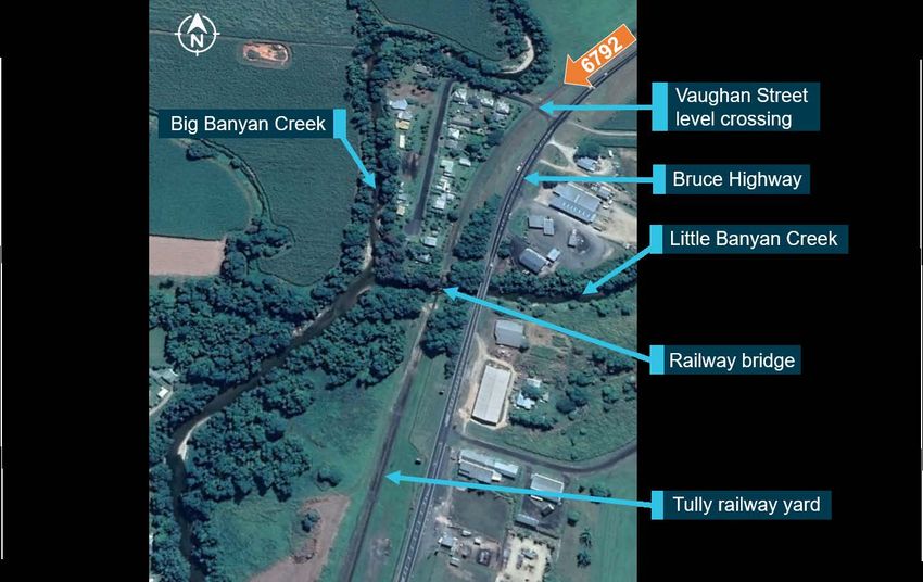
ATSB – RO-2018-007

Safety summary
What happened
At 0152 on 7 March 2018, freight train 6792, operated by Aurizon, departed Cairns, Queensland, for a
journey on Queensland Rail’s North Coast Line. A condition affecting the network (CAN) due to wet
weather had been declared, and the train crew were required to operate at controlled speed for a
significant part of the journey, which meant they were to be able to stop short of an obstruction within half
the distance of clear line that was visible ahead.
At 0612, the train rounded the curve prior to the Little Banyan Creek rail bridge, which was under 0.6 m
of flowing water. With a sighting distance of about 60 m to the bridge, the train’s speed
(50 km/h) was significantly in excess of the controlled speed, and the train entered the floodwater. The
train crew were not injured, but there was some damage to the train’s rolling stock, caused by immersion
in water.

What the ATSB found
The Little Banyan Creek weather monitoring station’s water level sensor had been out of service for 57
days, and therefore no flood alarm was provided to network control and passed on to the train crew.
Further, although there was a closed circuit television camera (CCTV) at the location to enable
monitoring of water levels, the illuminator to enable effective operation at night had been out of service
for 14 days. Queensland Rail (QR) also did not have an effective means of ensuring that, during
situations such as a CAN, network control personnel were aware of the relevant weather monitoring
systems that were unserviceable. In addition, QR did not have procedures that required network control
personnel to actively search for information about track conditions ahead of a train during situations
when conditions had the realistic potential to have deteriorated since the last patrol or train had run over
the relevant sections.
The ATSB also found that QR did not have any restrictions on the distance or time that controlled speed
could be used as a risk control for safe train operation in situations such as a CAN. The effectiveness of
controlled speed has the significant potential to deteriorate over extended time periods due to its effect
on driver workload, vigilance, fatigue and risk perception. In addition, Aurizon’s procedures and guidance
for two-driver operation during situations such as a CAN did not facilitate the effective sharing of duties
and teamwork to minimise the potential effects of degraded conditions on driver workload and fatigue.

What's been done as a result
Following the occurrence, QR improved its processes for ensuring the reliability of weather monitoring
systems, and its procedures for ensuring network control personnel were aware of any faults. QR also
developed new procedures and training for network control personnel for managing a CAN, including for
proactively monitoring conditions on the network. In addition, QR is undertaking further work to guide the
use and conditions around controlled speed and restricted speed, and Aurizon is undertaking further
work to review its procedures for the management of workload in two-driver operations during a CAN.

Safety message
This occurrence highlights the importance of having serviceable weather monitoring stations at known
flooding locations on a rail network, especially during the tropical wet season, and ensuring that if these
systems are not functioning then all relevant parties are aware of the problem.
This occurrence also highlights the importance of effective communication between all relevant parties
during a condition affecting the network. In particular, train controllers need to ensure that all relevant
information associated with the conditions is passed on to train crews and track maintenance personnel
so that they can effectively perform their roles.
ATSB – RO-2018-007

Contents
  The occurrence ........................................................................................................................1
       Overview                                                                                                                          1
       Events prior to train 6792’s departure                                                                                            1
       Cairns to Innisfail                                                                                                               2
       Innisfail to Little Banyan Creek                                                                                                  3
       Post-occurrence events                                                                                                            6
  Context ......................................................................................................................................7
       Train and train crew information                                                                                                         7
            Train information                                                                                                                   7
            Train crew roles and experience                                                                                                     7
            Train crew recent history                                                                                                           8
       Rail line information                                                                                                                    8
            North Coast Line                                                                                                                    8
            Little Banyan Creek                                                                                                                 8
            Track inspection procedures                                                                                                         9
            Areas prone to flooding                                                                                                           11
            Previous occurrences of trains entering floodwater                                                                                12
       Meteorological and environmental information                                                                                           12
            General information                                                                                                               12
            Forecasts and warnings                                                                                                            12
            Rainfall observations                                                                                                             14
            Water level information                                                                                                           14
       Queensland Rail weather monitoring stations                                                                                            14
            General information                                                                                                               14
            Water level monitoring                                                                                                            15
            Total hourly rainfall monitoring                                                                                                  15
            Derived rainfall rate of change monitoring                                                                                        16
            Closed-circuit television cameras                                                                                                 16
       Network control information                                                                                                            17
            Townsville control centre                                                                                                         17
            Network control personnel information                                                                                             17
            QR procedures and guidance for managing wet weather events                                                                        17
            Use of weather monitoring station and CCTV information                                                                            21
            Awareness of the status of weather monitoring stations and CCTV systems                                                           22
       Train operations information                                                                                                           22
            Aurizon procedures and guidance for managing wet weather operations                                                               22
            Additional information related to wet weather operations                                                                          23
            Procedures for communicating with network control                                                                                 24
            Communications involving train 67P8                                                                                               24
       Controlled speed                                                                                                                       25
            Operational speed restrictions                                                                                                    25
            Application of controlled speed on 7 March 2018                                                                                   25
            Implementation of controlled speed on other occasions                                                                             27
            Use of restricted speed in the United States                                                                                      27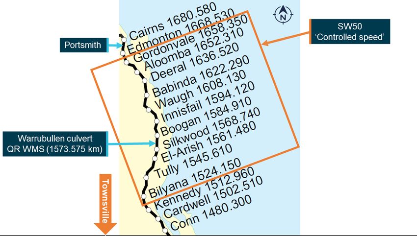
ATSB – RO-2018-007

Safety analysis ...................................................................................................................... 29
      Introduction                                                                                                                     29
      Use of patrols or inspections                                                                                                    29
      Serviceability of weather monitoring stations                                                                                    29
      Processes for actively monitoring conditions ahead of a train                                                                    30
      Communications between operational personnel                                                                                     31
      Train operating speed                                                                                                            32
          Use of controlled speed                                                                                                      32
          Expectancy                                                                                                                   33
          Workload and divided attention                                                                                               33
          Workload and sustained attention                                                                                             34
          Fatigue                                                                                                                      34
          Summary                                                                                                                      35
      Requirements to operate at controlled speed                                                                                      35
      Management of train crew workload                                                                                                36
Findings ................................................................................................................................. 37
      Contributing factors                                                                                                                 37
      Other factors that increased risk                                                                                                    37
Safety issues and actions ................................................................................................... 39
General details ...................................................................................................................... 44
     Occurrence details                                                                                                                44
     Train details                                                                                                                     44
Sources and submissions .................................................................................................. 45
     Sources of information                                                                                                45
     References                                                                                                            45
     Submissions                                                                                                           46
Australian Transport Safety Bureau .................................................................................. 47
      Purpose of safety investigations                                                                                47
      Developing safety action                                                                                        47
      Terminology used in this report                                                                                 48
ATSB – RO-2018-007

The occurrence
Overview
At 0152 1 on 7 March 2018, freight train 6792, operated by Aurizon, departed Cairns, Queensland,
for a journey to Brisbane, Queensland. 2 Heavy rain had fallen in some areas of North Queensland
in the preceding hours (night of 6 March) and continued to fall during 7 March. At 0612, the train
ran into floodwater over the Little Banyan Creek rail bridge, 134 track km south of Cairns. The
train crew were not injured, but there was some damage to the train’s rolling stock, caused by
immersion in water.

Events prior to train 6792’s departure
During 5–6 March, Queensland Rail’s (QR’s) North Coast Line was closed for a 36-hour period for
planned track maintenance near Rockhampton in Central Queensland. In addition, during the first
week of March 2018, a significant amount of rain fell in some areas of North Queensland.
On 6 March, the track maintenance supervisor (TMS, see Track inspection procedures) based at
Innisfail conducted a patrol of the track between the Babinda to Cardwell section (Figure 1). The
patrol started at 0655 and was completed at 1145. No areas of concern were identified.
Figure 1: Section of North Coast Line from Cairns to Cardwell

The image shows stations and their distance (in track km) from Roma Street Station in Brisbane.
Source: QR, modified by the ATSB.

During 6 March, the Townsville network control centre commenced preparations to run Aurizon
freight train 6792 and Pacific National freight train 67P8 south from Cairns, with the first train
expected to depart early on 7 March. These would be the first trains on the Babinda to Cardwell
section since the 6 March track patrol.
A ‘condition affecting the network’ (CAN) associated with the wet weather was declared before
trains 6792 and 67P8 departed. The regional transit manager (RTM) on duty at the network

1   All time references in this report are in local time (Eastern Standard Time).
2   The train departed from the Portsmith railway yards, about 2.5 km south of Cairns, and the intended destination was
    the Acacia Ridge intermodal terminal, about 12 km south of Brisbane.

                                                               ›1‹
ATSB – RO-2018-007
control centre on 6 March (up until 2030) directed that trains 6792 and 67P8 were to run at
‘controlled speed’, which meant they were to be able to stop short of an obstruction within half the
distance of clear line that was visible ahead (see Controlled speed).
At 0050 on 7 March, the train crew (consisting of a driver at the controls and a second driver) of
Aurizon train 6792 signed on for duty. At 0127, the driver phoned the network control officer
(NCO) on the Townsville North control board. The NCO issued the crew with a written authority for
rail traffic (form SW50), which directed them to operate their train at controlled speed between
Gordonvale (1658.350 km) 3 and Bilyana (1524.150 km) due to the weather conditions. The
controller advised the driver that he did not think the conditions were ‘anything to be too
concerned about’, but he requested that the train crew provide advice about the weather and track
conditions while en route. The NCO advised that there was no opposing traffic and that train 67P8
would be following close behind them.
Cairns to Innisfail
At 0151, train 6792 left Cairns in heavy rain and at 0222 it passed through Gordonvale (1,658.350
km). At 0228, the driver reported very heavy rain at Aloomba (1,652.310 km), and the NCO
reminded him to continue to report on the weather conditions as the train proceeded south.
At 0200, the driver of Pacific National train 67P8 contacted the NCO, and the NCO provided the
train crew with a form SW50, which directed them to operate the train at controlled speed between
Gordonvale and Bilyana due to the weather conditions. Train 67P8 departed Cairns at about 0220
and travelled about 30 minutes behind train 6792.
At 0308, the driver of the Aurizon train 6792 phoned the NCO 4 and advised that the creek at
Babinda (1,622.290 km) was about 1 m from the bottom of the bridge and flowing quickly. He also
noted that on the previous day the water was 2 m below the bridge. The driver stated that the rain
had eased off, but he was unsure of what was happening in the nearby hills, where water could
flow down rapidly. Soon after (at 0314), the NCO advised the driver that he could see on closed-
circuit television (CCTV) images from Babinda that the water was about 1 m below the rails.
During the phone call, the NCO also provided the 6792 train crew with a form SW50 for the Mamu
Road level crossing (1,602.913 km), located between Waugh and Innisfail. The level crossing had
been indicating active to road vehicle users all night, and the form SW 50 required the crew to
ensure there was no road traffic prior to entering the crossing.
At about 0333, train 6792 passed through Waugh (1,608.130 km). Soon after, the driver and NCO
discussed aspects of the shunting the train crew needed to do in Innisfail. The driver reported it
was raining heavily at that time.
At 0345, the driver advised they had passed through the Mamu Road level crossing. He also
advised that they had stopped at the Garradunga tramway because the signal was incorrectly
indicating red. The second driver had inspected the site and could not rectify the problem.
At about 0400, train 6792 arrived at Innisfail (1,594.120 km) and the train crew commenced
shunting operations for the next hour. The crew subsequently reported that it was raining heavily
at Innisfail during this period.
At 0400 there was an NCO shift change on the Townsville North control board. The incoming
NCO received a handover from the outgoing NCO and a briefing from the RTM (on duty since
2030), and he was advised that trains 6792 and 67P8 were required to be running at controlled
speed.
3 All distances are in km from Roma Street station in Brisbane.
4 Most of the communications between the driver and the NCO after the train departed Cairns were via train control
radio. However, the driver initiated some communications by mobile phone.
›2‹ATSB – RO-2018-007
The Innisfail track maintenance supervisor (TMS) contacted the NCO by phone at 0456 and they
discussed the overnight weather conditions. The NCO advised that there had been a rainfall alarm
at Babinda (north of Innisfail) at 2340, indicating more than 25 mm of rain had fallen in an hour.
There had also been a flood alarm at Warrubullen Culvert (1,573.575 km, near Silkwood and
about 20.5 km south of Innisfail), indicating that the water level had reached 1 m below the rails at
0311.
The NCO and TMS agreed that the TMS should conduct a patrol (See Track inspection
procedures) of the 120 km of track between Babinda and Cardwell (south of Innisfail). The NCO
advised the TMS of the current and expected rail traffic on the line. The TMS asked the NCO if the
train crews had seen anything, and the NCO replied that they had not reported anything yet. The
TMS advised the NCO that he would commence duty at 0600 and would arrive at Babinda at
about 0630 to begin the patrol, following trains 6792 and 67P8 south. He noted that his patrol
would therefore be conducted before QR’s Spirit of Queensland passenger train operated from
Cairns to Townsville.
Innisfail to Little Banyan Creek
At 0504, train 6792 departed Innisfail. The driver and the NCO briefly discussed the weather
conditions. The driver advised that it was still raining, and the NCO requested that the crew keep
providing updates about the conditions.
Train 6792 passed through Boogan and Silkwood and, at about 0552, it passed through El Arish
(1,561.48 km). At 0554 the driver phoned the NCO and advised that it was not raining at El Arish,
but the water level was 2.5 feet (about 0.75 m) below the rail bridge over Whing Creek and 2 m
below the rail bridge over Big Maria Creek (Figure 2). He noted that both creeks were flowing
rapidly.
›3‹ATSB – RO-2018-007
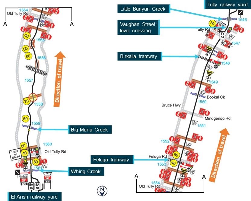
Figure 2: Route map showing features along the North Coast Line between El Arish and
Old Tully Road (left) and Old Tully Road to Little Banyan Creek (right)
Note: the diagram is oriented so that the train’s direction of travel is upwards (south). Speed limits are shown in yellow circles; distances
are shown in blue text.
Source: QR.
At 0610:09, the driver phoned the NCO and reported that all the culverts between Feluga and
Birkalla (Figure 2) were full. He also reported that there was a culvert at the Birkalla tramway
crossing where the water was about halfway up the ballast (see also Additional information related
to wet weather operations). He advised the NCO to monitor that location because if the water got
any higher it would start flowing through and start scouring out the ballast.
At 0611:18, the driver asked the NCO to stay on the phone so he could report on the water level in
Little Banyan Creek (1,546.100 km). He also noted that it would be interesting to see the condition
of Murray Flats (1,534.410 km), given the water level in the previous culverts.
At 0611:35, the train rounded the left curve on the approach to the rail bridge over Little Banyan
Creek (Figure 3). The train’s speed was about 50 km/h, with the maximum permitted speed in
normal conditions being 70 km/h. The driver saw floodwater covering the bridge and he
immediately attempted to stop the train by applying the emergency brake. The train was unable to
stop in the distance available, and it entered the water at 0611:50 (Figure 4).
›4‹ATSB – RO-2018-007
Figure 3: Train 6792’s route on approach to the Little Banyan Creek rail bridge
Source: Google Maps, modified by ATSB.
The distance from brake application to the train stopping was 294 m. After it stopped, the train
was on the bridge with the locomotive and first three container wagons partially submerged in
about 0.6 m of water (Figure 5). Neither of the train crew were injured.
Figure 4: Train 6792’s locomotive passing over the flooded Little Banyan Creek rail
bridge
Source: QR.
›5‹ATSB – RO-2018-007
Figure 5: Empty container wagons behind train 6792’s locomotive, standing on the
flooded Little Banyan Creek rail bridge
Source: QR.
Post-occurrence events
The driver of 6792 was still on the phone to the NCO as the train entered the floodwater and he
immediately notified the NCO of the problem.
The train crew were unable to leave the locomotive due to the surrounding water, and they also
believed it was unsafe for them to remain in that position. At 0615, after consulting with their
supervisor and the NCO, the driver moved the train forward at low speed through the floodwater
and into Tully yard.
After the NCO was notified of the collision with floodwater, the relevant section of track was closed
and the following train (67P8) was held at Innisfail.
Train 6792’s crew were replaced by a relief crew. Following discussions between train crew and
the rollingstock defect coordinator, the coordinator understood that the water ingress to wheel
bearings was minimal. On this basis the relief train crew was authorised to continue to the nearest
servicing depot at Townsville. At about 1730 on 7 March, the relief train crew restarted the train
and continued south. After running 43 km, the locomotive failed and the train was unable to
continue any further. Aurizon subsequently reported that, following a detailed inspection of the
train, it identified water damage to the traction motors and all wagon wheel bearings that had been
submerged in water.
›6‹ATSB – RO-2018-007
Context
Train and train crew information
Train information
Aurizon train 6792 was an intermodal freight train, servicing customers between Cairns
(Portsmith) and Brisbane (Acacia Ridge). On 7 March 2018, train 6792 departed Cairns with one
diesel electric locomotive (number 2806) and 28 container wagons. During shunting at Innisfail,
three wagons were detached and five other wagons were attached, which resulted in the train
having 30 wagons and being 603.5 m long with a gross mass of 1.054 t. Many of the containers
on the train were empty, but several were loaded with old road vehicle tyres, bananas and tea.
No problems were identified with the train’s braking performance or other relevant systems.
The train was fitted with a data logger and information from the data logger has been included in
the report where relevant. All reported speeds have been rounded to the nearest 5 km/h.
Train crew roles and experience
Train 6792 was operated in the two-driver operation configuration, with a planned crew change in
Townsville. In this configuration, two qualified locomotive drivers conducted a variety of duties up
to a maximum shift length of 12 hours.
Aurizon’s General Operational Safety Manual stated that, when rail traffic was worked in the two-
driver operation configuration, driver duties included:
Rail Traffic Driver at controls
• take charge of running of the rail traffic
Rail Traffic Driver not at controls to monitor
• other drivers performance
• signal aspects
• speed board changes
• level crossings
• other safeworking requirements
Note: By agreement with the rail traffic driver at the controls, the other rail traffic driver can take a short
break when it is considered safe to do so and when not in or approaching a Safety Critical Zone.
Both drivers of train 6792 on 7 March 2018 were based in Townsville. They advised that they
determined their division of duties before the train departed Cairns. Consistent with their normal
practice, they intended to swap driving duties at Bilyana, about halfway between Cairns and
Townsville. Up until then, one driver would conduct all train driving, safeworking and reporting
duties (including all communications with NCOs).
Driver 1 conducted the driving duties up until the time of the occurrence. He confirmed that there
were no requirements for drivers to share driving and related duties when operating a train during
a condition affecting the network (CAN) or abnormal event, such as in wet weather conditions.
Driver 2 inspected the train prior to departing Cairns, inspected the signals at Garradunga
tramway, and handled the shunting duties in Innisfail yard. During the shunting at Innisfail, heavy
rain fell and his clothes were saturated. In the period between departing Innisfail and the
occurrence, driver 2 put on dry clothes and dried out in the locomotive cab, and conducted
monitoring duties.
Both drivers were qualified to work trains between Townsville and Cairns. Driver 1 had a
substantial amount of train driving experience, having first qualified as a driver in 1995, and he
›7‹ATSB – RO-2018-007
had a substantial amount of experience on the North Coast Line. In the preceding 12 months, he
had worked over the route 65 times. Driver 2 had worked the route 16 times in the preceding
12 months.
Train crew recent history
Over the 4 days prior to the occurrence, driver 1 had worked four duty periods, as shown in
Table 1. He conducted no duty periods in the previous 4 days.
Table 1: Actual duty times for driver 1 over previous 5 days
Date Work activity Duty start Duty end Duty time Time free
(of duty)
3 Mar 2018 Day off
4 Mar 2018 Townsville–Cairns 0400 1330 9.5 hours 14.5 hours
5 Mar 2018 Cairns–Townsville (road vehicle) 0400 1000 6.0 hours 20.0 hours
6 Mar 2018 Townsville–Cairns (road vehicle) 0600 1150 5.8 hours 13.0 hours
7 Mar 2018 Cairns–Townville (planned) 0050 1250 12.0 hours
Train 6792 normally departed during the day but, due to the backlog associated with the closure of
the North Coast Line associated with planned maintenance, a non-standard start time was
required. On 6 March driver 1 and driver 2 drove a road vehicle from Townsville to Cairns to
position themselves to operate train 6792 back to Townsville. They signed off duty at 1150 and
went to motel accommodation to rest.
Driver 1 reported he had some sleep in the afternoon and woke for dinner. He then returned to
sleep for a couple of hours and was woken at midnight by a phone call from the train operator. He
stated that at that time he was tired, as was normal for a duty time that commenced in the middle
of the night. The driver’s planned and actual duty periods met the requirements of the operator’s
fatigue management system.
Driver 2 worked the same duty periods as driver 1 on 6–7 March, and had the previous 2 days
free of duty.
Rail line information
North Coast Line
Queensland Rail’s (QR’s) North Coast Line extends 339 km from Townsville to Cairns. Most of the
line runs along the foot of the coastal ranges or crosses river flood plains, with major rail bridges
over the Mulgrave, Russell, Johnstone, Tully, Murray and Herbert Rivers. In several sections, the
route crosses hilly terrain where there can be landslips from cutting faces and fallen trees across
the line after periods of wet weather. Some sections of the line have relatively poor alignment, with
many tight curves, low bridges and level crossings.
Between Gordonvale and Bilyana, there were 10 sections, with a total distance of 134.2 km. Over
the 10 sections, there were a significant number of sites that could be associated with potential
hazards. These potential hazards included 83 bridges, 56 speed-restricted curves, 20 sugar cane
tramway crossings and 79 level crossings (only 14 equipped with active level crossing protection).
There were usually 17 scheduled passenger and freight trains in each direction each week,
operated by QR (5), Aurizon (6) and Pacific National (6). These included QR’s Spirit of
Queensland passenger train, which ran between Cairns and Brisbane.
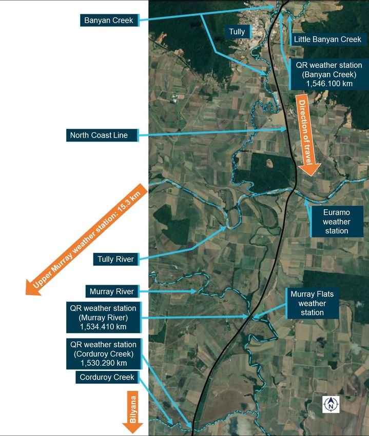
Little Banyan Creek
Banyan Creek is part of the Tully River catchment. It has a small catchment, bounded by the
Walter Hill Range and Mount Mackay. The creek flows south along the foot of the range, and its
›8‹ATSB – RO-2018-007
major tributary, Little Banyan Creek, flows south-west to a point of confluence about 1 km north-
east of Tully. Banyan Creek joins the Tully River downstream about 7 km further south.
QR’s North Coast Line crossed Little Banyan Creek at 1,546.100 km, about 80 m from the
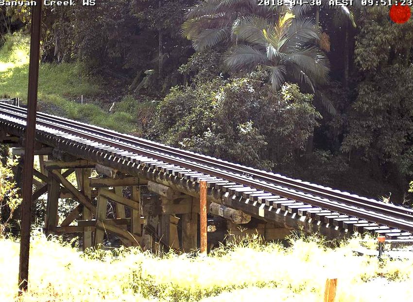
confluence with Banyan Creek. The timber trestle bridge was about 40 m long (Figure 6).
Figure 6: Little Banyan Creek rail bridge
Source: QR.
Approaching Little Banyan Creek and Tully yard from the north, the rail track curved to the left on
a 502 m radius curve after the Vaughan Street level crossing and dropped down to the bridge
(Figure 3). Trains were permitted to run at a maximum speed of 70 km/h around the left curve and
over the bridge. At the southern side of the bridge, the maximum speed limit changed to 60 km/h.
Train crew visibility going around the left curve before the bridge was restricted by large trees
beside the track, on the inside of the curve (Figure 3). This meant that a driver in a locomotive
could not see the bridge until they were about 60 m away.
Calculations conducted by QR determined that, for a freight train similar to train 6792, a driver
would have to be operating at a speed of 15 km/h in order to stop within 60 m.
Track inspection procedures
The QR Civil Engineering Track Standard (CETS), document MD-10-575, specified the safety
standards and good practice guidelines for the construction and maintenance of track owned by
QR.
›9‹ATSB – RO-2018-007
The standard provided for the following types of track inspections:
• scheduled patrol
• scheduled general inspection
• scheduled detailed inspection
• unscheduled patrol
• unscheduled general Inspection
• unscheduled detailed Inspection.
Scheduled patrols were required to be conducted at a maximum interval of every 96 hours. Such
patrols involved examining the track and related infrastructure. They were usually conducted by a
single infrastructure worker driving an on-track (hi-rail) vehicle 5 along the track, at a speed not
exceeding 40 km/h. Scheduled general inspections (maximum interval 4 months) and detailed
inspections (maximum interval 4 years) were more detailed in nature.
The CETS stated that unscheduled patrols, unscheduled inspections or operational restrictions
had to be applied in response to various events. These included ‘heavy rainfall / inundation /
floods / washaways / ingress of ground water’. The standard also required the rail infrastructure
manager to prepare and maintain a hazard location register. The register needed to detail the
hazards and the required actions (such as unscheduled patrols or inspections) at hazard locations
where defined events might rapidly reduce the capability of the track to safely perform the required
function. It stated such locations included track adjacent to an overbridge and track subject to
flooding.
The hazard location register for the North Coast Line, from Cains to Cardwell, was last updated in
August 2017. It listed 29 locations, with the associated condition or situation of 19 of these
locations related to flooding. Some referred to specific locations (such as Banyan Creek) whereas
some referred to a distance of up to 14 km of track. Most (14) of the locations were north of
Banyan Creek and some (4) were south of Banyan Creek.
Table 2 shows the hazard location entries for Little Banyan Creek (1,546.100 km) and the area
immediately north or south. Most of the other entries in the register associated with flooding were
similar to the first row in the table.
5 Light vehicle capable of operating on rail tracks and the road network.
› 10 ‹ATSB – RO-2018-007
Table 2: Selected hazard location register entries for locations near Little Banyan Creek
Location Activity, process, Defined event Action if event Record of event
condition or occurs
situation
1530.000 to Flooding and After heavy rain during wet Cease traffic Yearly during wet
1544.300 km washouts season. Track starts to until inspected season in extreme
flood when Murray River heavy rain
reaches 7.6 metres or Tully
River reaches 8.1 m at
Euramo
1545.300 to Flooding and After heavy rain during wet Cease traffic Yearly during wet
1546.300 km washouts season until inspected season in extreme
heavy rain
1546.082 to Flooding and debris After heavy rain during wet Cease traffic Yearly during wet
1546.130 km on bridge season until inspected season in extreme
Banyan Ck heavy rain. Train
ran through
flooded bridge
March 08
1546.900 to Flooding and After heavy rain during wet Cease traffic Yearly during wet
1547.700 km washouts season until inspected season in extreme
heavy rain
Source: QR, modified by the ATSB.
The track maintenance supervisor (TMS) based in Innisfail was responsible for the Babinda to
Cardwell section of track. He reported that scheduled patrols were normally done twice a week,
once in the northern direction and once in the southern direction. The TMS last conducted a patrol
on 6 March (the day before the incident) in a southern direction, which was completed at 1145.
After a discussion with the NCO at 0456 on 7 March, he planned to commence another patrol in
the southern direction starting at Babinda at about 0630 that morning.
The TMS stated that he was not permitted to conduct patrols at night due to various safety
concerns. He said that he had only conducted inspection activities at night in recent years in
response to specific incidents at specific locations.
Areas prone to flooding
QR’s Townsville network control centre had developed flood hot spot maps for each of its lines.
The map for the North Coast Line from Cairns to Townsville, dated 2010, showed 11 flood hot
spots between Gordonvale and Bilyana. These included two spots pointing to the area between
Tully (1,545.610 km) and Bilyana (1,524.150 km), with an associated table stating these spots
included the areas from 1,531.000–1,548.000 km and 1,530.000–1,544.300 km. The location of
QR’s weather monitoring stations was also marked. However, the labels for the flood hot spots
and the weather monitoring stations did not include specific location names.
The TMS based at Innisfail had been working in that or similar roles for more than 10 years. He
stated that the main areas prone to flooding of the track between Cairns and Bilyana included
Harvey Creek (1,632.310 km), Codfish Creek (1,627.270 km), Babinda Creek (1,621.510 km) and
the area between 1,530–1,550 km, which included crossings at Little Banyan Creek
(1,546.100 km), Murray River (1,5434.410 km) and Corduroy Creek (1,530.290 km) (Figure 7).
The TMS also advised that Little Banyan Creek could get flooded due to localised rain. That is, on
some occasions the creek would be flooded but Tully River and other nearby creeks and rivers the
rail line traversed would not be flooded.
› 11 ‹ATSB – RO-2018-007
Previous occurrences of trains entering floodwater
QR reported that there had only been one previous occurrence during the period from January
2008 to March 2018 when a train had entered floodwater on the North Coast Line. That event
occurred at Little Banyan Creek on 14 March 2008.
QR advised that it could not locate an investigation report for the March 2008 occurrence, and
therefore the detailed circumstances associated with that occurrence were not able to be
determined. The information available to QR indicated that crews of trains that passed over the
Little Banyan Creek rail bridge provided reports of the water levels at 2245 on 13 March 2008
(1.5 m below the rails), 2315 (dropping since last report) and 0020 on 14 March 2008 (same as
last report). However, at 0145 freight train 6C55 went through water that was about 1.2 m above
the rails. A situation update at 0500 indicated that other creeks along the line were at least 1.9 m
below the rails but Little Banyan Creek was still 1 m over the rails at 0630.
Meteorological and environmental information
General information
The North Coast Line between Cairns and Townsville experiences a wet season from about
November to March each year. According to QR, during this period it was common for the network
to be impacted by localised flooding in the numerous rivers and creeks over which the line
crossed.
Tully is one of the wettest towns in Australia, with an average annual rainfall of 4,083 mm and an
average March rainfall of 756 mm.
Forecasts and warnings
In the first week of March 2018, heavy rain fell in many areas of North Queensland. Rain forecast
maps issued by the Bureau of Meteorology (BoM) on the morning 6 March 2018 indicated that the
area between Cairns and Tully would receive up to 50 mm of rain on 6 March, up to 100 mm on
7 March and between 100–200 mm on 8 March.
BoM issued an initial flood watch at 1514 on 6 March 2018 for coastal catchments between
Cooktown (north of Cairns) and Ingham (between Cardwell and Townsville). It stated:
• Areas of heavy rainfall were expected to develop across the flood watch area later on 7 March
and continue into 8 March.
• Minor flood levels were likely across the flood watch area from late on 7 March.
• Heavy rainfall may lead to local flooding.
• Catchments likely to be affected included the Mulgrave, Russell, Johnstone, Tully, Murray and
Herbert Rivers.
BoM issued an initial minor flood warning for the Tully and Murray rivers (Figure 7) at 0549 on
7 March. It stated that rainfall totals of 70–300 mm had been recorded across the Tully River
catchment since 0900 on 6 March, with the bulk of the rain falling overnight, and further showers
then rain were expected. For the Tully River, the warning stated:
River levels are rising in upper reaches of the Tully River.
The Tully River at Euramo is currently at 5.53 metres and rising. The Tully River at Euramo will
exceed the minor flood level 6 (6.00 m) Wednesday morning. Further rises are likely as heavy showers
continue. Predictions will be updated as required.
6 BoM’s description of minor flooding included ‘Causes inconvenience. Low-lying areas next to watercourses are
inundated. Minor roads may be closed and low-level bridges submerged...’
› 12 ‹ATSB – RO-2018-007
For the Murray River (south of the Tully River), the warning stated:
River level rises are being recorded in the Murray River catchment.
River levels are expected to remain below minor flood levels at Murray Flats during Wednesday but
with further heavy rainfall expected from Wednesday evening rises above the minor flood level are
likely during [8 or 9 March].
QR advised that it received the publicly-available weather forecasts and warnings provided by
BoM and had processes in place to assess them and their potential impact on its network. It did
not have any arrangements in place for BoM to directly contact QR.
Figure 7: Position of rivers, creeks, and weather stations near Tully
Source: Google earth, annotated by ATSB
› 13 ‹ATSB – RO-2018-007
Rainfall observations
As indicated above, the initial flood watch stated that locations in the Tully River catchment
recorded 70–300 mm of rain between 0900 6 March and 0500 on 7 March.
Table 3 shows daily rainfall figures for 6 and 7 March 2018 for the Tully Sugar Mill (1.35 km south-
west of the Little Banyan Creek rail bridge) and some other locations close to the North Coast Line
in the Tully River catchment (Euramo and Upper Murray) and north of the Tully River catchment
(Mulgrave Hill, Deeral and Innisfail).
Table 3: Rainfall for selected locations 6–7 March 2018
Location 24-hour rainfall to 0900 24-hour rainfall to 0900
6 March 2018 (mm) 7 March 2018 (mm)
Mulgrave Hill (Gordonvale) 0.0 88.0
Deeral 0.2 69.0
Innisfail 48.6 151.0
Tully Sugar Mill (near Little Banyan Creek) 71.0 226.5
Euramo (near 1,539.000 km) 55.0 74.0
Upper Murray (11.2 km west of Bilyana) 106.0 70.0
Source: QR, modified by the ATSB.
Water level information
The closest locations to Little Banyan Creek with recorded water level data were:
• Euramo (near a road bridge crossing Tully River, 500 m south-east of the North Coast Line at
1,539.000 km). The water level reached 4.98 m at 0400 on 7 March and was increasing. It
reached the minor flood level of 6.00 m at 0712 and the moderate flood level of 8.00 m at
2219. It subsequently reached 8.80 m at 0141 on 9 March, below the major flood level of
9.00 m.
• Murray Flats (near a road bridge crossing Murray River, 50 m from the rail bridge crossing
Murray River at 1,534.410 km). The water level reached 5.05 m at 0400 on 7 March and was
increasing. It reached the minor flood level of 7.00 m at 2226, the moderate flood level of
7.50 m at 0414 on 8 March, and the major flood level of 8.00 m at 1138.
Queensland Rail weather monitoring stations
General information
QR had weather monitoring stations at 10 locations between Gordonvale and Bilyana, including at
Little Banyan Creek. The stations could provide various types of information to the Townsville
network control centre, including air temperature, rail temperature, humidity, rainfall and water
level. Some parameters were only available for some locations. If a specific value was exceeded,
the station would transmit an alarm message.
The weather monitoring station at Little Banyan Creek provided information on air temperature,
rail temperature, rainfall and water level.
In October 2017, QR commenced testing of weather monitoring stations on the North Coast Line
prior to the wet season. Accordingly, a 6-month service of the Little Banyan Creek station was
conducted on 31 October 2017, and the system was found to be fully operational.
Weather monitoring station sensors in North Queensland are exposed to extreme weather
conditions and regularly experienced faults. Such faults were allocated a lower priority, relative to
other types of equipment faults, as they were deemed to be ‘non-vital’ assets that did not directly
impact on the movement of rail traffic. Vital systems, including level crossings and signalling
› 14 ‹ATSB – RO-2018-007
systems, were recognised as essential to the movement of rail traffic and were generally accorded
a higher priority.
The QR weather monitoring stations were independent of other weather monitoring stations, such
as those used by BoM for rainfall at the Tully Sugar Mill and the water level at Euramo and Murray
Flats (see Meteorological and environmental information).
Water level monitoring
Nine of the 10 QR weather monitoring stations between Gordonvale and Bilyana, including at
Little Banyan Creek, had a water level sensor. These sensors were mounted on rail bridges and
measured the vertical distance between the water and the top of the rails.
If the distance reached a certain level, the system would send a flood alarm message. The
calibrated levels for a flood alarm were 1.0 m, 0.4 m and 0.1 m below the rails, at rail height, and
0.2 m, 0.5 m and 1.0 m above the rails. All flood alarm messages were sent to the relevant
network control officer (NCO) workstation and the regional transit manager (RTM) workstation
within the Townsville network control centre.
On 10 January 2018, while working on the Little Banyan Creek rail bridge, a QR maintenance
gang damaged a cable running from the water level sensor. A technician attended the site and
identified that repairs were required.
On 18 January 2018, a QR engineer, who was monitoring cameras at the site, noted the water
level in Little Banyan Creek had risen to the top of the sleepers on the bridge, but the flood alarm
had not activated. A new water level sensor was ordered, and a technician attended the site in
mid-February to install it. However, the technician was unable to calibrate the sensor. At the time
of the occurrence on 7 March 2018, the water level sensor had not been calibrated and it was still
offline.
In addition to Little Banyan Creek, QR advised that the water level sensors at two other weather
stations between Gordonvale and Bilyana had a ‘failed’ status during the period between 0000
and 0600 on the morning of 7 March. These were Swann Creek (1,656.500 km) and Murray River
(1,534.410 km). The Murray River sensor, located close to the Murray Flats station used by BoM,
had a failed status since 9 February. 7
QR advised that the only flood alarm message sent to the network control centre during the 12-
hour period leading up to the occurrence was at 0311 on 7 March from the Warrubullen weather
monitoring station (1,573.575 km), which stated that the water level was 1 m below rail height.
Total hourly rainfall monitoring
All 10 of the QR weather monitoring stations between Gordonvale and Bilyana, including at Little
Banyan Creek, recorded rainfall. One of the two rainfall parameters that was monitored was total
hourly rainfall, or the total amount of rain recorded over the previous 60 minutes (calculated every
5 minutes).
If the total hourly rainfall was over 25 mm the system would generate a warning alarm message,
and if it was over 50 mm the system would generate a critical alarm message. Warning and critical
alarm messages for total hourly rainfall were sent to the relevant NCO workstation and critical
alarm messages were sent to the RTM workstation.
On 7 March 2018 at 0039, a warning message was recorded indicating that the total hourly rainfall
at Little Banyan Creek was more than 25 mm (actual value 25 mm). 8 QR advised that this should
have generated a warning alarm message, however no message was sent. QR advised that
7 In addition, the weather monitoring stations at two other locations were temporarily offline (for all parameters) during 7
March, including Harvey Creek (1,632.310 km) during 0108–0245 and 0545–0612 and Corduroy Creek (1,530.290 km)
during 0246–0740.
8 The same message was also recorded on 6 March 2018 at 0358.
› 15 ‹ATSB – RO-2018-007
following the occurrence it identified that the system as delivered by external developers had not
been correctly configured, which meant that a higher amount of rainfall (in the order of 30 mm)
was required before a warning message was sent from the device to the server. QR also advised
that it had commenced an investigation of these types of issues prior to the occurrence.
The only total hourly rainfall alarm message received by the network control centre during the
12-hour period leading up to the occurrence was at 2340 on 6 March from the Babinda weather
monitoring station, which stated that the total hourly rainfall over the last hour was more than
25 mm (actual value 27 mm).
Derived rainfall rate of change monitoring
The other monitored rainfall parameter was derived rainfall rate of change, or the estimated rainfall
per hour based on the amount of rain measured over a 5-minute period.
If the derived rainfall rate was over 25 mm/h, the system would generate a critical alarm message.
These critical alarm messages for derived rainfall rate were sent to RTM workstation but not the
relevant NCO workstation.
For Little Banyan Creek, critical alarm messages were recorded:
• 6 March at 1503
• 6 March at 2039
• 7 March at 0015.
All three messages stated that the derived rainfall rate changed to more than 25 mm/h (actual
value 28 mm/h).
Closed-circuit television cameras
Some locations along the North Coast Line had a closed-circuit television (CCTV) system that
provided images that were able to be viewed by the relevant NCO and the RTM. The systems
included an illuminator, which allowed a camera to capture artificially-illuminated images during
the hours of darkness.
Between Gordonvale and Bilyana, there were four CCTV systems, located at Swann Creek
(1,656.500 km), Babinda (1,621.510 km), Little Banyan Creek (1,546.100 km) and Murray River
(1,534.410 km). The CCTV at Little Banyan Creek was installed in September 2015.
The CCTV systems automatically generated a new still image every 2 hours. In addition, network
control personnel could generate a new image manually at any other time.
On 22 February 2018, QR’s Townsville fault coordination centre received a notification that the
camera illuminator at Little Banyan Creek had failed. In its failed state, the images taken by the
camera at night were too dark for any detail to be discerned.
A technician was sent to Little Banyan Creek to repair the illuminator, but was not able to access
the site due to inclement weather conditions. At the time of the occurrence on 7 March 2018, the
camera illuminator had not been repaired.
Morning civil twilight 9 on 7 March 2018 at Tully commenced at 0555. The presence of water over
the bridge was discernible on the CCTV footage from about 0550.
9 There are three phases of twilight: civil, nautical and astronomical. The sun is below the horizon in each phase, but in
civil twilight there is sufficient natural light to carry out most outdoor activities.
› 16 ‹ATSB – RO-2018-007
Network control information
Townsville control centre
QR’s Townsville control centre consisted of seven control boards, one for each line. A separate
network control officer (NCO) provided network control services at each board. An NCO was
responsible for controlling rail traffic in accordance with safeworking procedures and conducting
related duties.
A regional transit manager (RTM) supervised the overall operations of the NCOs on duty, as well
as coordinated activities with external parties. A network support officer assisted the RTM.
The Townsville North control board was responsible for the North Coast Line from Purono
(1,368.060 km) to Cairns (1,680.580 km). It was also responsible for the Tablelands Branch from
Cairns to Croydon. The Townsville North control board’s workstation included several monitors for
displaying safeworking (train progress) information. There was also a communications monitor
and another monitor that was used for a range of other tasks, including ViziRail 10 monitoring, GPS
location assurance, weather monitoring, email monitoring, access to procedures and sourcing
other operational information.
The RTM’s workstation also included a monitor that provided weather-related information.
A large monitor in the control centre displayed current weather radar information for the area from
the BoM website.
Network control personnel information
The NCO who commenced duty on the Townsville North control board at 0400 on 7 March 2018
was qualified on five control boards, including the Townsville North board. He had about 3.5 years
experience as a controller. He reported that he worked mainly as a relief controller, filling in for
others as required, and therefore there could be extended periods where he did not work on the
Townsville North control board. He stated that he did not have much experience with far north
Queensland wet seasons, and was not aware that Little Banyan Creek was a known location
prone to flooding.
During the NCO’s shift, the only traffic on the North Coast Line in the area he was responsible for
were trains 6792 and 67P8. During the period after civil twilight (0555) he was dealing with some
traffic on the Tablelands Branch, including processing a release for one train at 0600 and issuing
a warrant for a track vehicle at 0610.
The RTM on duty in the Townsville control centre at the time of the occurrence was normally a
network support officer, but acted in the role of an RTM about once per month. He had conducted
RTM duties over a 7-year period, and had previously worked as an NCO in the centre for
15 years. He was aware that Little Banyan Creek was a known location prone to flooding.
The RTM signed on at 2100 and was due to sign off at 0630. He stated that the workload during
this shift was higher than normal, due to the wet weather and the planned reopening of the North
Coast Line after a significant period of closure due to planned maintenance, which affected the
Townsville North control board and other control boards.
QR procedures and guidance for managing wet weather events
General rules and procedures
The QR standard MD-12-189 (Queensland Network Rules and Procedures), outlined the safety
requirements for all persons who were required to access and perform activities in the network rail
corridor managed by QR. The standard included rules and procedures for operating rail traffic in
10 Train scheduling, monitoring and reporting software module.
› 17 ‹ATSB – RO-2018-007
flood-affected areas (QR 3027). It stated that if an NCO was made aware of flood-affected track,
the NCO must stop the rail traffic and arrange inspection by a maintenance representative.
QR 3027 also stated that, when ‘the track is affected by flooding’, a maintenance representative
must arrange for track workers to monitor the height of any water and report damage to the NCO,
tell the NCO about any rise or fall of the water level, check the condition of the track before any
traffic travels through flood-affected areas, and advise the NCO of operating restrictions on
affected track. The standard noted that the height of water could be checked using automatic
weather stations (where fitted).
MD-12-189 also included rules and procedures for reporting and responding to a condition
affecting the network (QR 2009). It stated:
Conditions that can or do affect the safety of operations in the Network must be reported promptly to
the Network Control Officer responsible for the affected portions of line…
If necessary, the Competent Worker reporting the Condition Affecting the Network must:
• prevent rail traffic from approaching the affected portions of line, and
• apply protection for rail traffic or a line in an emergency.
If there is any doubt about the safety of rail traffic, any fault must be treated as an emergency and
workers must:
• tell the Network Control Officer…
The QR standard MD-10-107 (General Operational Safety Manual) outlined the instructions and
procedures for rail traffic movements and other matters. With regard to adverse conditions, it
stated:
Where it is required to operate rail traffic in adverse conditions such as:
• heavy rain,
• high wind, or
• reduced visibility…
and these conditions affect or have the potential to affect the safe operation of rail traffic and people
on the network, the rail traffic crew will operate their rail traffic to suit the current conditions and advise
Network Control of the conditions
Network Control should consult with rail traffic crew, Track Maintenance Supervisors and any other
resources available and determine other factors which may impact on the running of rail traffic.
Where information is available to Network Control that relates to the condition of the network, the
Network Control Officer will advise if it is unsafe for rail traffic to travel.
The Network Control Officer will impose such special conditions as may apply when rail traffic travel
under adverse conditions and these include but are not limited to:
• continual monitoring
• restricted speed
• increased exchange of information to ensure safety
• updates on changes in weather conditions
Local guidance information
Supplementary to the QR rules and procedures, the Townsville Regional Safety Committee
published a set of ‘wet weather protocols’ in December 2011 for use by NCOs in the Townsville
control centre. These protocols, which were not a formal part of QR’s safety management system,
included the following guidance:
• We will stop trains when conditions are uncertain, or until track inspection verifies safe for
traffic. For example…
› 18 ‹ATSB – RO-2018-007
o Weather monitors alert to a problem
o Water is in the ballast
o Visibility is poor
o There is a report from the last train over the section that indicates a problem…
• We recognise the importance of sharing information and will focus on the quality of our
conversations by:-
o Provide weather report advice to train drivers at the start of their shift when needed.
o Observe and report on conditions that could stop traffic when travelling across the
corridor. For example water levels rising, water entering the ballast and or sever
localised storms.
o Sharing information from Train Control on weather conditions to trains in transit
where applicable…
Safety alerts
In December 2015, an Aurizon freight train derailed near Julia Creek on QR’s Mount Isa Line,
following a flooding event that scoured the ballast and formation of the track. The ATSB
investigation 11 identified the following safety issues associated with QR’s procedures:
• The Queensland Rail General Operational Safety Manual (MD-10-107) contained insufficient
guidance for rail traffic crews to ensure the timely identification and management of a potential
hazard (resulting from a weather event) that might affect the safe progress of the train. [RO-
2015-028-SI-01]
• The Queensland Rail network rules, procedures and safety manual [MD-12-189] provided
insufficient guidance to identify the magnitude of the potential hazard from a weather event, or
define the response when encountering water that had previously overtopped the track and
receded or was pooled against the track formation or ballast. [RO-2015-028-SI-02]
In January 2016, following the December 2015 derailment, QR issued critical safety alerts to rail
traffic crew and network control officers. QR advised the ATSB that the safety alerts were to be
trialled over the 2016–2017 wet season and then incorporated into relevant manuals. A
subsequent version of the critical safety alert for NCOs was issued in November 2016 and
reissued in November 2017.
The 2016/2017 critical safety alert stated:
If Train Traffic Crew observe flood water (or evidence of recent flood water such as debris on the
track) in the ballast (above the formation) they must immediately stop the rail traffic (in a controlled
manner) and report to the NCO. The rail traffic must not proceed until authorised (verbally) by the
NCO. The NCO must consult with relevant infrastructure personnel prior to providing this
authorisation.
• Note: This rule does not apply to puddles, drainage water or small volumes of water that
would not impact on the structural integrity of the track.
NCOs may become aware of a wet weather related conditions that affect or potentially affect the
network by:
• Reports from the field of
o unusually heavy rain;
o water pooling against the formation or on land adjacent to the railway;
o a washout or scouring of ballast or the formation;
o poor visibility;
11 ATSB Transport Safety Report, Rail Occurrence Investigation RO-2015-028, Derailment of freight train 9T92, near Julia
Creek, Queensland, 27 December 2015. Report issued 9 December 2016. Available at www.atsb.gov.au.
› 19 ‹You can also read