Sentinel Lake Assessment Report Greenwood Lake (16-0077) Cook County, Minnesota - Minnesota Pollution Control Agency Water Monitoring Section ...
←
→
Page content transcription
If your browser does not render page correctly, please read the page content below
Sentinel Lake Assessment Report
  Greenwood Lake (16-0077)
    Cook County, Minnesota

      Minnesota Pollution Control Agency
          Water Monitoring Section
        Water Quality Monitoring Unit
                       &
  Minnesota Department of Natural Resources
              Section of Fisheries
             September 2015
Contributing Authors
                                   Steve Heiskary, MPCA
                           Steve Persons and Jodie Hirsch, MDNR

                                           Editing
                          Jesse Anderson and Pam Anderson, MPCA
                             Jeff Reed and Brian Herwig, MDNR

                                          Sampling
                             Minnesota Pollution Control Agency
                                 Water Monitoring Section
                              Water Quality Monitoring Unit
                                             &
                         Minnesota Department of Natural Resources
                                    Section of Fisheries

                                           Web ID
                                      wq-2slice16-0077

The MPCA is reducing printing and mailing costs by using the Internet to distribute reports and
       information to wider audience. For additional information, see the Web site:
                        www.pca.state.mn.us/water/lakereport.html
This report was printed on recycled paper manufactured without the use of elemental chlorine
                 (cover: 100% post-consumer; body: 100% post-consumer)
Table of Contents
List of Tables .......................................................................................................................................... ii
List of Figures ........................................................................................................................................ iii
Executive Summary ................................................................................................................................ 1
Introduction ............................................................................................................................................. 3
History .................................................................................................................................................... 3
Background ............................................................................................................................................. 4
   Lake Morphometric and Watershed Characteristics .......................................................................... 4
   Ecoregion and Land Use Characteristics ........................................................................................... 6
   Lake Level ........................................................................................................................................... 9
   Precipitation and Climate Summary ................................................................................................. 10
Methods................................................................................................................................................. 12
   Fisheries and Aquatic Plants ............................................................................................................ 12
   Zooplankton ...................................................................................................................................... 13
Results and Discussion.......................................................................................................................... 13
   Fisheries Assessment......................................................................................................................... 13
   Water Quality .................................................................................................................................... 22
   Phytoplankton ................................................................................................................................... 32
   Zooplankton ...................................................................................................................................... 34
Trophic Status Trends ........................................................................................................................... 39
303(d) Assessment ................................................................................................................................ 44
Recommendations ................................................................................................................................. 45
References ............................................................................................................................................. 46
List of Appendices ................................................................................................................................ 49
   Appendix A ........................................................................................................................................ 49
   Appendix B ........................................................................................................................................ 50
   Appendix C ........................................................................................................................................ 51

Sentinel Lake Assessment of                                                                     Minnesota Pollution Control Agency and
Greenwood Lake in Cook County                                                               Minnesota Department of Natural Resources
                                                                           i
List of Tables
Table 1 Greenwood Lake and watershed morphometric characteristics. Lake bathymetry based
on latest sounding map from 1987 ................................................................................................................. 5
Table 2 Greenwood Lake watershed ecoregion land use comparison. Typical (interquartile) range based on
NLF ecoregion reference lakes noted for comparison (Heiskary and Wilson 2005). ..................................... 7
Table 3 Detailed comparison of Greenwood Lake watershed land use composition based on
1992 and 2011 NLCD (in hectares). % change and direction is relative to 1992. .......................................... 9
Table 4 Number of fish per set, and mean weight (pounds/fish) for Lake Trout, Cisco,
Lake Whitefish, Smallmouth Bass, and Yellow Perch taken in gill net sets (deep and shallow combined) in
surveys of Greenwood, Cook County, Minnesota, 1955-2013.. ....................................................................19
Table 5 Number of fish per set, and mean weight (pounds/fish) for Smallmouth Bass, Yellow Perch, White
Sucker, Green Sunfish, and Brook Trout taken in 0.75-in-mesh trap net sets in surveys of Greenwood,
Cook County, Minnesota, 1955-2013............................................................................................................20
Table 6 Number of fish per set, and mean weight (pounds/fish) for White Sucker and Smallmouth Bass
taken in shallow gill net sets (GSH), and Lake Trout and Cisco taken in deep gill net sets
(GDE), in surveys and assessments of Greenwood Lake, Cook County, Minnesota, 1980-2013. ................21
Table 7 Mean length (in) at last annulus formation for age-3, age-4, age-5, age-6, and age-7
Lake Trout collected in assessments or surveys of Greenwood Lake, Cook County, Minnesota,
1955-2013......................................................................................................................................................21
Table 8 Greenwood Lake 2013-2014 summer-mean water quality data. Typical range based on
32 NLF ecoregion reference lakes (Heiskary and Wilson 2008) noted for comparison. ...............................22
Table 9 Greenwood Lake cation, anion, and total organic carbon measurements. Typical interquartile (IQ)
range derived from 150 NLA lakes sampled in 2012 is provided as a basis for comparison. Weighted
percentiles reflect number (%) of lakes in the ecoregion that have values less than Greenwood..................23
Table 10 TDO3 values from DNR and MPCA profiles measured in August in Greenwood Lake
from 1986 through 2014 ................................................................................................................................27
Table 11 Prominent algal species present in Greenwood. Includes species with ~10% or greater occurrence
in samples. .....................................................................................................................................................33
Table 12 Prominent algal species present in Trout. Includes species with ~10% or greater
occurrence in samples....................................................................................................................................33
Table 13 Total phytoplankton taxa and diatom richness metrics for Greenwood. Nearby Sentinel Lakes
Trout and Tait included for comparison. Mean values derived from an analysis of 13
Sentinel Lakes (Heiskary and Hirsch 2015). .................................................................................................34
Table 14 Prominent zooplankton taxa present in Greenwood Lake. Taxa with ~10% or greater occurrence
in samples noted. ...........................................................................................................................................36
Table 15 Prominent zooplankton taxa present in Trout Lake. Taxa with ~10% or greater
occurrence in samples noted. .........................................................................................................................36
Table 16 Zooplankton taxa richness, average seasonal densities and average seasonal biomass (excludes
nauplii and copepodites).. ..............................................................................................................................37
Table 17. MINLEAP model results for Greenwood Lake .............................................................................43
Table 18. Eutrophication standards by ecoregion and lake type (Heiskary and Wilson, 2005). Greenwood
Lake 2013-2014 summer means; long-term means provided for comparison. ..............................................44

Sentinel Lake Assessment of                                                                        Minnesota Pollution Control Agency and
Greenwood Lake in Cook County                                                                  Minnesota Department of Natural Resources
                                                                             ii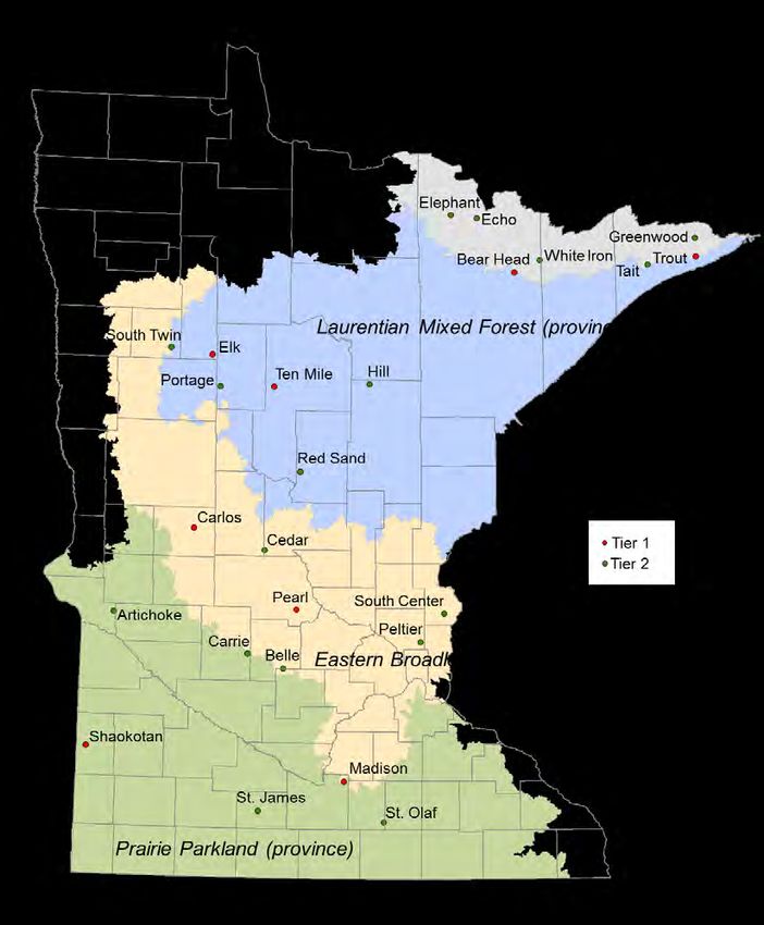
List of Figures
Figure 1 MDNR map of Sentinel lakes and major land types. Trout, Elk, and Carlos are “Super Sentinel”
lakes. ............................................................................................................................................................... 2
Figure 2 Aerial image of Greenwood Lake and immediate area around the lake (Google Earth image
8/2013) ........................................................................................................................................................... 5
Figure 3 Greenwood Lake bathymetric map. Red “x” indicates primary water quality
monitoring site. ............................................................................................................................................... 6
Figure 4 USEPA ecoregion map with lakes noted. ........................................................................................ 7
Figure 5 Greenwood Lake watershed. Mapped land use from 2011 NLCD (top) and 1992 NLCD (bottom).8
Figure 6 Greenwood Lake level elevations in 2014. Based on MDNR data. ................................................. 9
Figure 7 2014 monitoring season rainfall based on records for Grand Marais, MN. State
Climatology Office Data ...............................................................................................................................10
Figure 8 2013-2014 Minnesota water year precipitation and departure from normal (State
Climatology Office data). ..............................................................................................................................11
Figure 9 Ice-out dates for Greenwood Lake as collected by MDNR. Dates range from the earliest Julian
date 101 (4/10/2012) to latest 144 (5/24/2014). ............................................................................................12
Figure 10 Greenwood Lake temperature and dissolved oxygen (DO) profiles 2013 and
2014 (MPCA). ...............................................................................................................................................24
Figure 11 Greenwood Lake 2006 profiles and a comparison of July 10 and 11 2006 dissolved
oxygen and comparison of temperature profiles for Greenwood, Devils Track, Wilson, Moose,
and Trout Lakes. ............................................................................................................................................25
Figure 12 MDNR late summer (August) DO and temperature profiles for Greenwood ...............................26
Figure 13 Surface temperatures (MPCA) for Greenwood Lake ....................................................................26
Figure 14 Depth layers of optimal (green), suitable (yellow), and unsuitable (red) Lake Trout
thermal habitat in Greenwood Lake from 1977 through 2013 based on August profiles. .............................28
Figure 15 Greenwood Lake surface (0-2m) TP & Chl-a based on data in STORET. ...................................30
Figure 16 Greenwood Lake 2013 & 2014 surface (0-2m) and near bottom (30m) TP..................................30
Figure 17 Greenwood Lake Secchi transparency measurements for 2006, 2013 and 2014 ..........................31
Figure 18 Greenwood Lake cation concentrations: 1991 and 2013-2014 .....................................................31
Figure 19 Greenwood Lake dissolved organic carbon, silica and sulfate: 1991 and 2013-2014 ...................31
Figure 20 Greenwood and Trout Lake percent composition of algal forms and relative
contribution to algal biomass based on Chl-a................................................................................................33
Figure 21 Greenwood Lake phytoplankton metrics ......................................................................................34
Figure 22 Greenwood and Trout Lake 2013 and 2014 zooplankton density and biomass ............................35
Figure 23 Spiny waterflea densities (number individuals/cubic meter) from Greenwood Lake,
2013-2014......................................................................................................................................................38
Figure 24 Spiny waterflea densities (number individuals/cubic meter) from Trout
Lake, 2013-2014. ...........................................................................................................................................38
Figure 25 Greenwood Lake TSI values from 2008-2010 MPCA Sentinel Lake monitoring data .................40
Figure 26 Greenwood Lake TP, chlorophyll-a and Secchi trends: 2006-2014 ..............................................41
Figure 27 Greenwood Lake transparency trends: a) summer-mean Secchi (long-term mean [5.1 m]
indicated by green line). Standard error of the mean noted for Secchi (Note if SE=0 implies only
one measurement).and b) Secchi residuals. ...................................................................................................41
Figure 28 Greenwood Lake remote-sensed transparency (a) and long-term mean = 4.3m
(green line) and b) Secchi residuals. ..............................................................................................................42
Figure 29 Greenwood Lake Trophic State Index values based on summer-means .......................................42

Sentinel Lake Assessment of                                                                           Minnesota Pollution Control Agency and
Greenwood Lake in Cook County                                                                     Minnesota Department of Natural Resources
                                                                              iii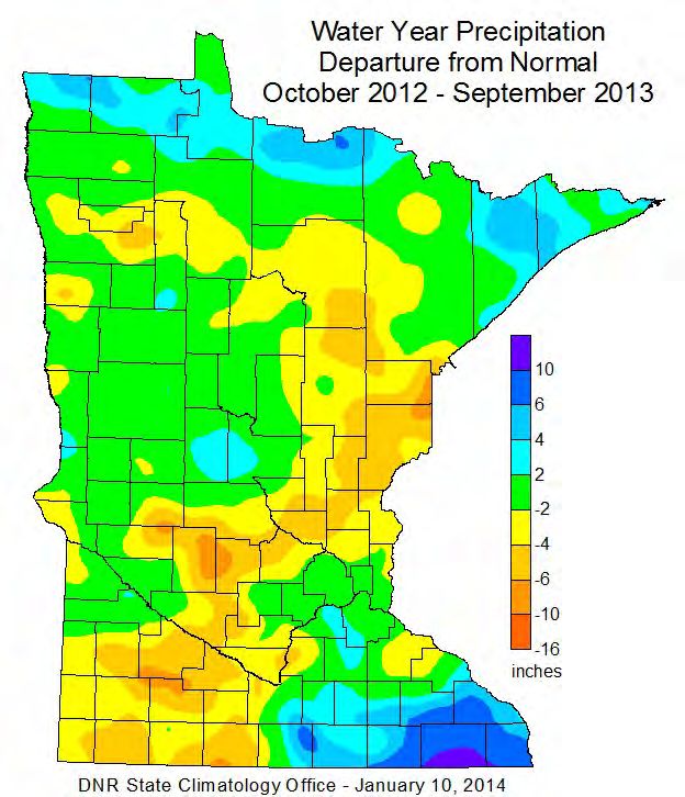
Executive Summary
The Minnesota Pollution Control Agency (MPCA) is working in partnership with the Minnesota
Department of Natural Resources (MDNR) on the Sustaining Lakes in a Changing Environment (SLICE)
Sentinel Lakes Program. The focus of this interdisciplinary effort is to improve understanding of how
major drivers of change such as development, agriculture, climate change, and invasive species can affect
lake habitats and fish populations, and to develop a long-term strategy to collect the necessary
information to detect undesirable changes in Minnesota Lakes (Valley 2009). To increase our ability to
predict the consequences of land cover and climate change on lake habitats, SLICE utilizes intensive lake
monitoring strategies on a wide range of representative Minnesota lakes. This includes analyzing relevant
land cover and land use, identifying climate stressors, and monitoring the effects on the lake’s habitat and
biological communities.

The Sentinel Lakes Program initially selected 24 lakes for long-term intensive lake monitoring (Figure
1). The “Deep” lakes typically stratify during the summer months. “Shallow” lakes are defined as
mixing continuously throughout the summer. “Cold Water” lakes are defined as lakes that either
harbor Cisco, Lake Whitefish, or Lake Trout and were the focus of research funded by the
Environmental and Natural Resources Trust Fund (ENRTF). “Super Sentinel” lakes also harbor cold-
water fish populations and research on these lakes is currently funded by the ENRTF. In the three
super sentinel lakes (Trout, Elk, and Carlos) lake and watershed models have been built by the U.S.
Geological Survey (USGS) to forecast various outcomes of climate change on coldwater habitat.
Information from this work will likely be beneficial for future analysis of Greenwood. Because of
financial and manpower limitations, the Sentinel Lakes were prioritized as Tier 1 and Tier 2 (Figure 1)
in 2012, whereby Tier 1 lakes would receive frequent, often annual or biennial, monitoring while Tier
2 lakes would be monitored less frequently.

Greenwood Lake was added to the Sentinel Lakes network in 2012 to provide an additional deep
oligotrophic lake that supported lake trout and is a Tier 2 lake. Greenwood Lake is located in Cook
County approximately 30.4 kilometers (19 miles) northeast of Grand Marais, MN, within Superior
National Forest. Greenwood Lake is located in a bedrock basin, and surrounded by forested land.
Land use within the Greenwood Lake watershed is dominated by forest, open water, and wetlands.
There has been little change in general land use since 1992, primarily because most of the watershed
is within the public lands of Superior National Forest; however, there has been a significant change in
the composition of the forest with a shift from deciduous forest (1992) to a evergreen, mixed and
shrub scrub forest (2011) as a result of forestry activity.

Greenwood Lake is a very dilute lake that is low in nutrients and dissolved minerals, consistent with other
lakes in this region. Based on recent water quality data (2013-2014), Greenwood Lake is considered to be
oligotrophic with total phosphorus (TP), chlorophyll-a (Chl-a), and Secchi transparency values of: 7
micrograms per liter (µg/L), 2.0 µg/L, and 5.2 meters (m; 18 feet) respectively. Secchi and Chl-a are at
expected levels relative to TP. The MINLEAP model predictions compare favorably to observed water
quality and indicate the lake exhibits water quality similar to that expected based on its size, depth,
watershed area, and location in the state. A subroutine in the model suggests current TP is near
background for the lake.

Secchi data are a bit sparse for the lake since there is no active CLMP volunteer. Existing Secchi records
and remote-sensed transparency suggest there may be a slight decline in transparency over time. However
the data are not sufficient to describe this as a statistically significant trend. Further data collection and
future analysis of this data will be needed to detect any trends in this system.

One benchmark measure of coldwater habitat (temperature at 3 mg O2 - TDO3; Jacobson et al. 2010)
suggests that coldwater resources in Greenwood are excellent for cisco and lake whitefish. The mean

Sentinel Lake Assessment of                                       Minnesota Pollution Control Agency and
Greenwood Lake in Cook County                                 Minnesota Department of Natural Resources
                                                  1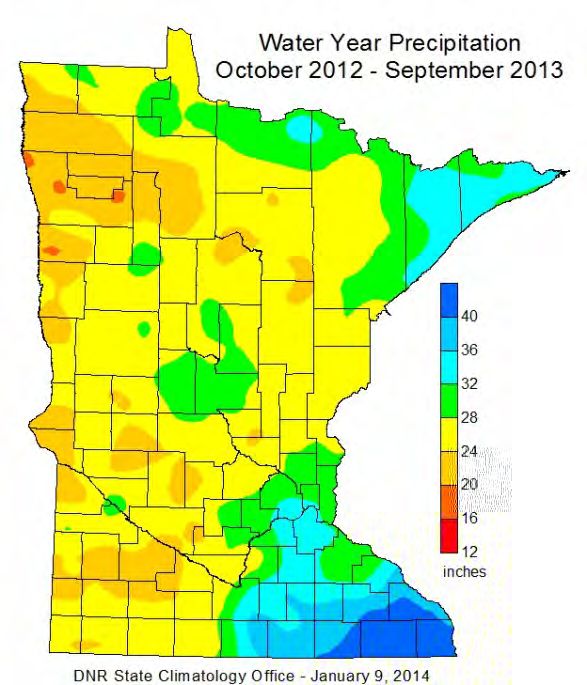
TDO3 was 8.3°C during the period of greatest oxythermal stress (August profiles). These routinely
collected measurements (mid-August) of each year will be valuable for assessing trends over time.

Zooplankton densities and biomass in Greenwood Lake were among the lowest of all the Sentinel lakes.
The low zooplankton density and biomass is directly related to low nutrients and low algal productivity.
Over the past few decades, an invasive zooplankton species (Bythotrephes longimanus), commonly
known as the spiny waterflea, has become established across the Great Lakes Region, invading many
lakes along the Minnesota and Ontario border. Greenwood Lake has a well-established population, first
detected in 2005, while Trout Lake has a newly infested population, first detected in 2012. Continued
monitoring of zooplankton and phytoplankton in both lakes will be of value for understanding the impact
of spiny waterflea on the base of the food chain of these lakes.

Figure 1 MDNR map of Sentinel lakes and major land types. Trout, Elk, and Carlos are “Super Sentinel” lakes.

Sentinel Lake Assessment of                                        Minnesota Pollution Control Agency and
Greenwood Lake in Cook County                                  Minnesota Department of Natural Resources
                                                   2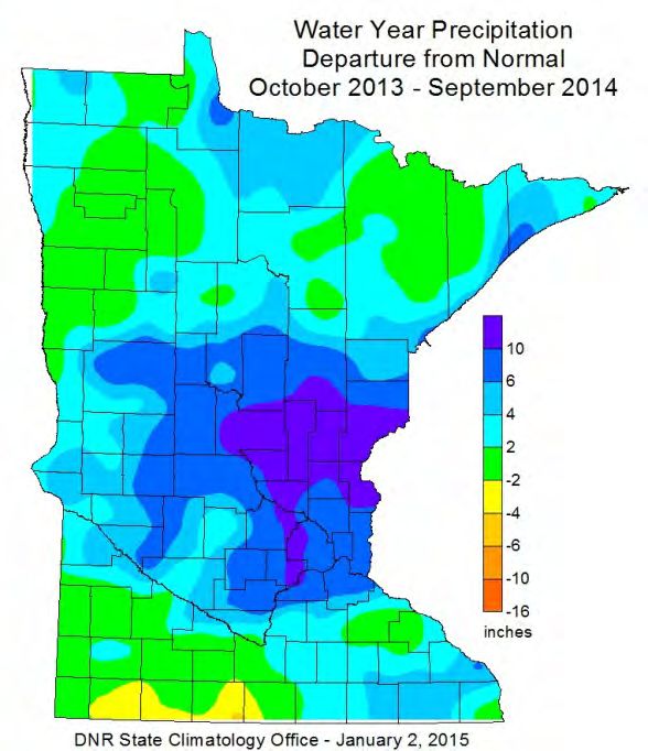
Introduction
This report provides a relatively comprehensive analysis of physical, water quality, and ecological
characteristics of Greenwood Lake in Cook County Minnesota (MN). This assessment was compiled
based on Minnesota Department of Natural Resources (MDNR) surveys of the lake’s fish community and
aquatic plant communities, Minnesota Pollution Control Agency (MPCA) water quality monitoring, and
analysis of various other sources of data for the lake. The water quality assessment focuses on data
collected during the 2013-2014 seasons; however, historical data provide perspective on variability and
trends in water quality. Water quality data analyzed includes all available data in EQuIS, the state
repository for water quality data. Further detail on water quality and limnological concepts and terms in
this report are described in the Guide to Lake Protection and Management:
(http://www.pca.state.mn.us/water/lakeprotection.html).

History
In this section of the report we summarize historical fishery management, water quality monitoring,
lakeshore development, and changes that may have occurred in the watershed over time. This
information is a combination of MDNR, Cook County, MPCA, and/or lake association records.

1936 Minimal temperature-oxygen profile and water chemistry data were collected. Rainbow Trout,
Brown Trout, Brook Trout, and Lake Trout were listed as the most abundant fish species, but no fish
collecting was done.

1943 An investigation of Greenwood Lake was completed by L. E. Hiner, an aquatic biologist
working for the Division of Game and Fish, Bureau of Fisheries Research. That report included
general observations on the lake, some water quality data, information on prospects for a commercial
Cisco fishery in the lake, and some late October fish population assessment data. Five experimental
gill net sets apparently caught only Cisco, White Sucker, and Lake Trout. The report indicated that
groundcover around the lake consisted of second-growth forest recovering from logging and
subsequent fires. One resort was present on Greenwood Lake in 1943 (Greenwood Lake Lodge).

1955 An initial survey was completed in August. Cisco (41.0 fish/net), Lake Trout (1.2 fish/net),
White Sucker (10.5 fish/net), and Walleye (1.1 fish/net) were collected in 14 gill net sets. The survey
reported there were 12 cottages and 1 resort on the lake at that time.

1977-2013 Numerous re-surveys and fishery assessments were conducted. Resurveys were conducted
in 1977, 1983, and 1986, and assessments were done in 1958, 1966, 1969, 1971, 1979, 1980, 1990,
1993, 1996, 1999, 2005, 2009, and 2013. In most years, 12 to 16 gill net sets were used. Trap nets
were also used most years and electrofishing gear was used in 1986, 1996, and 1999. Small mesh gill
nets were used in 1990 to check for the presence of Rainbow Smelt (none were collected) In the 2005
assessment, wire minnow traps baited with light sticks were set in deep water in an attempt to collect
deep-water sculpin (without success). After 1993 gill net sets in all assessments were divided into
deep and shallow sets, based on water temperature. Deep sets targeted Lake Trout, and most
assessments used about twice as many deep sets as shallow.

1977 MDNR lake survey reported one resort and 17 homes or cottages were found on the lake, all on
the lake’s west side (in Section 28). The count did not include one boarded up cabin found on a point
near the lake’s outlet.

1983 Greenwood Lake was included in the Acid Precipitation Intensive Monitoring Program, run by
MDNR Ecological Services. MDNR lake surveys were done as part of that program in 1983 and 1986.

Sentinel Lake Assessment of                                      Minnesota Pollution Control Agency and
Greenwood Lake in Cook County                                Minnesota Department of Natural Resources
                                                 3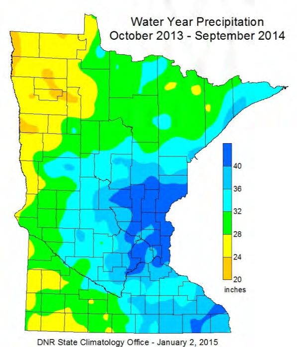
1984 Greenwood Lake was selected as an ecoregion reference lake by MPCA, water quality sampling
initiated.

1986 MDNR lake survey reported one resort and 30 homes or cottages were present.

1992-1993 New development of several home sites on the lake in the northeast basin.

1999 Parking at public access was upgraded and likely allowed for increased usage.

2005 Spiny water fleas first found in the lake. Firmly established by 2011

2006 Greenwood sampled in conjunction with Superior National Forest staff as part of a regional lake
study

2013 Greenwood Lake added to Sentinel Lakes network.

Background
Lake Morphometric and Watershed Characteristics
Greenwood Lake is located in Cook County within the Brule River watershed (Figure 2) that is a part of
the Lake Superior North major watershed (Appendix C). Greenwood Lake is located approximately 30.4
kilometers (19 miles) northeast of Grand Marais, MN, within Superior National Forest, just south of the
Boundary Waters Canoe Area Wilderness. A public access is located on the south end of the lake.
Greenwood Lake has been designated by the State of Minnesota as an Outstanding Resource Value Water
(Minnesota Rules, Chapter 7050.0470).

Greenwood Lake is located in a smooth to undulating moraine of the Rainy Lobe. Rainy Lobe till is
grayish brown, non-calcareous, and generally sandy with abundant fragments of igneous and
metamorphic and greenstone volcanic rocks (Goebel and Walton 1979). The lake has a comparatively
small watershed, made up of forest and wetland/water. Several small lakes are included in the “water”
land use with Squash, Potato, and Celery to the NW, North Shady immediately north, Sunfish south, and
Edith (Triangle) southeast. The watershed is drained through at least seven small tributaries and the lake
outlets to the south through the Greenwood River, which flows toward the Brule River and Lake
Superior. A barrier falls on the Greenwood River just below Greenwood Lake prevents the movement of
fish from the Brule and lower Greenwood Rivers into the lake. In a 1986 MDNR lake survey, late-
summer flows in the tributaries to Greenwood Lake were reported to have ranged from an unmeasurable
trickle (in three streams) to a high of 0.4 cfs in “NALAC Creek.” Similar tributary flows were noted in a
1983 lake survey. Mid-summer outlet flow measurements for the Greenwood River were made in 1941
(3.6 cfs), 1955 (0.8 cfs), 1977 (2.3 cfs), and 1986 (30.6 cfs). The Greenwood River is a designated trout
stream, supporting a wild (unstocked) Brook Trout population.

Greenwood Lake’s morphometric characteristics are summarized in Table 1. It is a large lake covering
972 hectares. The lake has a mean depth of 9.9 meters (32.5 feet), a maximum depth of 34.1 meters (112
feet) and 26 percent of the lake is littoral. Greenwood has numerous shoals and depths vary greatly; there
are two deeper basins in the lake, one near the center and the other in the eastern bay (Figure 3).

Percent littoral area refers to that portion of the lake that is 4.6 meters (15 feet) or less in depth, which
often represents the depth to which rooted plants may grow in the lake; on Greenwood this is limited to
near-shore areas. The volume of Greenwood Lake was estimated at 66,160 acre-feet, and the residence
time was estimated at ~15 years, reflective of the lake’s deep basin, limited inlets and small outlet.

Sentinel Lake Assessment of                                        Minnesota Pollution Control Agency and
Greenwood Lake in Cook County                                  Minnesota Department of Natural Resources
                                                   4
The watershed around the lake is relatively undeveloped as is much of the shoreline of the lake. Based
 on records from the Water Plan Coordinator for the Cook County Soil and Water District there are 55
 total home-sites with residents on the lake. There are more potential home sites, which are not
 developed. Of the 55 developed sites, 49 are seasonal and 6 are residential, homesteaded. A recent on-
 site septic system inspection of 43 properties indicates 30 were deemed non-compliant and 13
 compliant with current regulations. Of those non-compliant, 10 were deemed imminent public health
 threats. This suggests the possibility exists for these systems to pollute groundwater and the potential
 to impact drinking water sources.

 For systems deemed imminent public health threats, the County follows up with a letter to the
 property owners. After the allotted time to fix the system has passed, and if the system is not brought
 into compliance, then the County works with the County attorney and purses legal action. The County
 also works with landowners to provide low interest loans to bring systems into compliance and
 provide grants for low income, homesteaded landowners.

 Table 1 Greenwood Lake and watershed morphometric characteristics. Lake bathymetry based on latest
 sounding map from 1987

                           Lake      Littoral   Total Wshed      Wshed :     Max.      Mean        Lake
Lake Name     Lake ID       ha        Area          Area          Lake      Depth      Depth      Volume
                          (acres)      (%)       ha (acres)                 meters     meters     acre-ft
                                                                            (feet)     (feet)
Greenwood     16-0077       827       26%       2,824 (6,971)     3.4: 1      34.1      9.9       66,160
                          (2,042)                                            (112)     (32.4)

 Figure 2 Aerial image of Greenwood Lake and immediate area around the lake (Google Earth image 8/2013)

 Sentinel Lake Assessment of                                        Minnesota Pollution Control Agency and
 Greenwood Lake in Cook County                                  Minnesota Department of Natural Resources
                                                   5
Figure 3 Greenwood Lake bathymetric map. Red “x” indicates primary water quality monitoring site.
Ecoregion and Land Use Characteristics
Minnesota is divided into seven regions, referred to as ecoregions, as defined by soils, land surface
form, potential natural vegetation, and land use (Omernik 1987). Data gathered from representative,
minimally impacted (reference) lakes within each ecoregion serve as a basis for comparing the water
quality and characteristics of other lakes. Greenwood Lake lies within the Northern Lakes and Forest
(NLF; Figure 4) ecoregion. NLF values are used for land use (Table 2), summer-mean water quality
comparisons and model applications. Omernik level III and IV ecoregions provided a basis for the
“land type” delineations noted in Figure 1. This step was taken prior to selection of the Sentinel Lakes
and provided a means to most closely characterize geomorphological differences in lake condition. In
the NLF ecoregion, this allowed for differentiation between the “Canadian Shield” lakes and “Glacial
Drift Northern Forest” lakes.
As anticipated, land use within the Greenwood Lake watershed is similar to the ecoregion norms and
nearly all forest and open water/wetland. In general, there has been little change in basic land uses over
time, primarily because most of the watershed is within the public lands of Superior National Forest.
However, timber harvests in the watershed have been extensive, and are ongoing. The extent of past
harvest activity may best be illustrated by comparison of 1992 and 2011 NLCD land use maps (Figure 5)
and its summary (Table 3). This mapping indicates the extensive harvest of deciduous trees with about
40% remaining in 2011 as compared to 1992. This forest type was offset by increases in evergreen,
mixed, and scrub shrub forest (Table 3). All lakes in the Greenwood Lake watershed, and the Greenwood
River, are protected by the Shipstead-Newton-Nolan Act (SNN), which established a 400-ft no-harvest
buffer around those waters. Tributaries to Greenwood Lake are protected by Forest Resource Council
Guidelines for timber harvest along non-trout streams, but are not covered by the SNN.
Sentinel Lake Assessment of Minnesota Pollution Control Agency and
Greenwood Lake in Cook County Minnesota Department of Natural Resources
6Figure 4 USEPA ecoregion map with lakes noted.
Table 2 Greenwood Lake watershed ecoregion land use comparison. Typical (interquartile) range based on NLF
ecoregion reference lakes noted for comparison (Heiskary and Wilson 2005).
Land Use (%) Greenwood NLF ecoregion
(2011)1
Developed 1 0-7
Cultivated (Ag) 0Figure 5 Greenwood Lake watershed. Mapped land use from 2011 NLCD (top) and 1992 NLCD (bottom).
Sentinel Lake Assessment of Minnesota Pollution Control Agency and
Greenwood Lake in Cook County Minnesota Department of Natural Resources
8Table 3 Detailed comparison of Greenwood Lake watershed land use composition based on 1992 and 2011
NLCD (in hectares). % change and direction is relative to 1992.
Land use 1992 2011 % Change increase or
from 1992 decrease
open water 893 890Precipitation and Climate Summary
Climate and precipitation for the 2014 field seasons varied considerably. Rain gage records from Grand
Marais (the closest long-term climate station to Greenwood Lake) show five 2.5 centimeter (cm; 1 inch)
plus rain events during the 2014 field season. Of these, four occurred from April 25- July 6. While there
was continued precipitation after that point, it was reduced with 9.45 inches after as compared to 13.62
inches before July 6. Large rain events increase runoff into the lake and may influence in-lake water
quality and lake levels. An examination of temperatures for the Grand Marias climate station indicate that
the 2014 field season was slightly below normal with maximum of 84F, minimum of 27F, average of
51.6F, which was -0.9F below normal for the period. Overall, precipitation for 2013 was near-normal and
2014 was about 2-4 inches above normal, with rainfall on order of 32-36 inches for each water year
(Figure 8).
Figure 7 2014 monitoring season rainfall based on records for Grand Marais, MN. State Climatology Office
Data
Sentinel Lake Assessment of Minnesota Pollution Control Agency and
Greenwood Lake in Cook County Minnesota Department of Natural Resources
10Figure 8 2013-2014 Minnesota water year precipitation and departure from normal (State Climatology Office
data).
Ice-out dates can be a useful indicator of climate change. MDNR has recorded ice-out dates since
1998 (Figure 9). The median ice-out date was 127 (May 7, 2015) and ranged from the earliest date of
101 (April 4, 2012) to the latest 144 (May 24, 2014). No trend is evident based on these data;
however, this is a relatively short record and there will be a need for continued annual recordings if
this is to be a useful indicator. Ice-out data are found at this page
http://www.dnr.state.mn.us/ice_out/ice_out_by_lake.html?downum=16007700.
Sentinel Lake Assessment of Minnesota Pollution Control Agency and
Greenwood Lake in Cook County Minnesota Department of Natural Resources
11Figure 9 Ice-out dates for Greenwood Lake as collected by MDNR. Dates range from the earliest Julian date 101
(4/10/2012) to latest 144 (5/24/2014).
Methods
Fisheries and Aquatic Plants
Most recent fisheries surveys follow guidelines outlined by MDNR Special Publication 147 (1993;
Manual of Instructions for Lake Survey). Nearshore non-game fish surveys were also completed on
each Sentinel lake following methods described by Drake and Pereira (2002). Survey methods vary
somewhat over time and are addressed in more detail in Results and Discussion.
Frequency of occurrence of aquatic plant species will be assessed using the point-intercept method
(Madsen 1999). This method entails visiting sampling points on a grid within the vegetated zone of
the lake, throwing a two-sided rake over one side of the boat at each point, raking the bottom
approximately 1 meter (m), then retrieving the rake and identifying all species present, and recording
the depth. Survey points are typically spaced approximately 80-m (0.7 points per littoral acre). The
report will be updated when this data set is available. Score the Shore (Perleberg et al. 2014) was
conducted on Greenwood Lake in late summer of 2015 and emergent mapping of the lake is
anticipated to occur in 2016. The results of those efforts will also be added when data are available.
Water Quality
In 2013 and 2014 MPCA lake surface samples were collected with an integrated sampler, a poly vinyl
chloride (PVC) tube 2 meters (6.6 feet) in length, with an inside diameter of 3.2 cm (1.24 inches).
Zooplankton samples were collected with an 80 micrometer (µm) mesh, 30 centimeter (cm) simple
zooplankton net. Phytoplankton (algae) samples were taken with an integrated sampler. Deep total
phosphorous (TP) samples were collected with a Kemmerer sampler. Temperature and dissolved oxygen
(DO) profiles and Secchi disk transparency measurements were also taken by MPCA and MDNR staff.
Most profiles and Secchi transparency measurements were done at a sampling site located in the deepest
area of the central basin of the lake (Site 102; Figure 3). Sampling procedures were employed as
described in the MPCA Standard Operating Procedure for Lake Water Quality document, which can be
found here: http://www.pca.state.mn.us/publications/wq-s1-16.pdf . In addition to the individual DO and
temperature profiles, continuous temperature measurements were made by a string of sensors (thermistor)
Sentinel Lake Assessment of Minnesota Pollution Control Agency and
Greenwood Lake in Cook County Minnesota Department of Natural Resources
12suspended at 1-2 m intervals from the surface of the lake to one meter above the bottom in 2013 and
2014. These sensors record temperature at pre-defined intervals (e.g. hourly) and serve to complement the
discrete profiles.
Laboratory analysis was performed by the laboratories of the Minnesota Department of Health, using
United States Environmental Protection Agency-approved methods. Samples were analyzed for nutrients,
color, solids, pH, alkalinity, conductivity, chloride, metals, and chlorophyll-a (Chl-a). A list of methods
and reporting limits (RL) used in the 2014 sampling are included in the Appendix.
Phytoplankton samples were analyzed at PhycoTech using a modified rapid assessment technique which
was patterned after a method developed by MPCA staff. This technique allows for identification of major
algal forms (typically to species level) and estimates of relative biovolume and is similar to the technique
used on the other Sentinel Lakes; however, more species-level identification was provided by PhycoTech
analysts as compared to MPCA analysts. These analyses were part of a larger project to analyze
phytoplankton composition across several Sentinel Lakes, thus data from Trout Lake is available for
comparison to Greenwood Lake.
Zooplankton
Zooplankton samples were collected monthly from ice-out (May) through October 2013-2014.
Typical protocol calls for one vertical tow taken at each sampling event. Because Greenwood has
spiny waterflea, four tows were taken, one with a standard 80µ net and three with a large 0.5m, 250µ
net, which is intended to increase the likelihood of capturing spiny water flea (Bythotrephes
longimanus. The nets were lowered to within 0.5 m of the bottom and withdrawn at a rate of
approximately 0.5 meters per second. Contents were rinsed into sample bottles and preserved with
100% reagent alcohol for subsequent analysis by MDNR personnel.
Each zooplankton sample was adjusted to a known volume by filtering through 80 µm mesh netting and
rinsing specimens into a graduated beaker. Water was added to the beaker to a volume that provided at
least 150 organisms per 5-milliliter aliquot. A 5-milliliter aliquot was withdrawn from each sample using
a bulb pipette and transferred to a counting wheel. Specimens from each aliquot were counted, identified
to the lowest taxonomic level possible (most to species level), and measured to the nearest .01 millimeter
using a dissecting microscope and an image analysis system. Densities (#/liter), biomass (µg/L), percent
composition by number and weight, mean length (millimeter), mean weight (µg) and total counts for each
taxonomic group identified were calculated with the zooplankton counting program ZCOUNT
(Charpentier and Jamnick, 1994 in Hirsch, 2009).Total number of spiny waterfleas collected from each
250µ tow was enumerated separately. Densities were reported as number per cubic meter, averaged
across tows
Results and Discussion
Fisheries Assessment
Historical (pre-Sentinel assessment and survey)
The native fish community in Greenwood Lake was probably very simple, with major species perhaps
limited to Lake Trout, White Sucker, and Northern Pike. Over time, as a result of stocking done since
1926, and other introductions or movements of fish, the community has become more complex. Fish
species collected in Greenwood Lake to date (with year first collected in parentheses) include: Lake
Trout (1943), White Sucker (1943), Green Sunfish (1943), Northern Cisco (1943), Walleye (1955),
Lake Whitefish (1958), Yellow Perch (1958), Rainbow Trout (1966), Brook Trout (1966), Kokanee
Sentinel Lake Assessment of Minnesota Pollution Control Agency and
Greenwood Lake in Cook County Minnesota Department of Natural Resources
13Salmon (1967), Coho Salmon (1969), Creek Chub (1977), Smallmouth Bass (1980), Longnose Dace
(1986), Golden Shiner (1983), Splake (1983), and Northern Pike (2013). Of these, Rainbow Trout,
Kokanee Salmon, Coho Salmon, and Splake are no longer present. If Walleye are still present, their
numbers are very low. Meristic counts done by Dr. David Etnier on a sample of Northern Cisco taken
from Greenwood Lake in 2005 confirmed that the fish taken were Coregonus artedii. Prior to 2013,
Greenwood Lake was one of very few lakes in Cook County where no Northern Pike had ever been
collected, and the apparent absence of Burbot was also unusual in a lake of this type.
Lake Trout gill net catches in MDNR surveys have ranged from 0.4 fish/net (1958) to 6.0 fish/net
(1993; Table 4). Lake Trout gill net catches appeared to increase significantly between 1969 and 1980.
Since 1980 they have generally fallen in the 1.5-3.0 fish/net range, showing no clear trend. Gill net
catches in 2009 and 2013 fell short of the long range goal for the species (2.0 fish/set), and neither
assessment captured any fish over 30 inches in length. Historically, Lake Trout size distributions in
this lake have included fish up to 42 inches, but fish less than 19 inches dominate samples. Lake Trout
have exhibited average growth during their first few years of life, but after age 4, their growth
apparently slows (Table 7). Growth of age-6 and age-7 Lake Trout collected in various assessments
has usually been below average when compared to means for Schupp Lake Class 1 lakes in this area
(Schupp 1992).
Much of the past assessment effort on Greenwood Lake was directed at evaluating Lake Trout
stocking. To aid in that evaluation, all Lake Trout stocked after 1985 were fin-clipped (adipose). In the
1990, 1993, and 1996 assessments, natural reproduction accounted for most of the Lake Trout
collected. Very few fin-clipped Lake Trout over age 1 were collected in 1993; it appeared that stocked
fish accounted for no more than 5% of the age 2-9 Lake Trout collected that year. Fin-clipped Lake
Trout accounted for 25% of the Lake Trout collected in the 1999 assessment, but good natural year
classes had been produced in 1994, 1995, and 1996. The 2005 assessment provided the clearest
evidence that stocking of this lake was unnecessary; all of the Lake Trout collected that year were
produced naturally, and the catch was as high as any, during the years the lake was stocked.
Smallmouth Bass were first collected in Greenwood Lake in 1980. From 1980 to 1996, trap net
catches of Smallmouth Bass appeared to increase, with mean weight of trap-netted Smallmouth Bass
increasing slightly as well (Table 5). Catches of Smallmouth Bass in trap nets in 1999 and 2005 were
lower, with none taken in that gear in 2005; however, gill net catches over the same period (1996-
2005) were stable and anglers in 2005 and 2006 reported large numbers of small Smallmouth Bass in
the lake. Trap net catches rebounded in 2009 and 2013. In the 1980s, anglers reported an excellent
fishery for large Smallmouth Bass, but by 1993 most of the Smallmouth Bass collected in trap nets
were under 12 inches and the fish collected exhibited relatively slow growth. Age-4 Smallmouth Bass
collected in 1993 averaged 8.1 inches at last annulus formation, compared to the Cook County average
of 9.1 inches. Smallmouth Bass growth rates have since remained slow compared to rates observed in
other Class 1 lakes in this area.
Cisco gill net catches declined through 2005, but rebounded to historic levels in 2009 and 2013 (Table
4). Catches in deep gill net sets fell below the current long range goal (5.9 fish/deep gill net set) in
1996 and 2005, and barely met it in 1999; however, the goal was exceeded by a wide margin in 2009
and 2013 (Table 6). Cisco size distributions have included fish from 5 to 17 inches and have usually
been dominated by fish over 12 inches. Cisco collected in 1993 and 1999 exhibited relatively fast
growth; age-3 fish collected in 1999 averaged 12.5 inches at last annulus formation, compared to a
Cook County average of 10.1 inches. Growth of Cisco collected in 2013 was faster still; age-3 fish
reached a mean length of 13.7 in at last annulus formation. The 1999 catch included just two strong
year classes, with no fish older than age 3. In 2013 two strong year classes (2010 and 2011)
contributed to the catch, and fish as old as age 5 were collected. Cisco collected in 2013 ranged in
length from 9.5 to 20.0 in, with most in the 12-16-in length range.
Sentinel Lake Assessment of Minnesota Pollution Control Agency and
Greenwood Lake in Cook County Minnesota Department of Natural Resources
14Walleye were first sampled in Greenwood Lake in 1955, but they were never abundant, with gill net
catches peaking at just over one fish per net. Walleye were last sampled in 1980. Their decline and
eventual disappearance coincided with an increase in Lake Trout abundance, the introduction of
Smallmouth Bass, and the reclamation of Sunfish Lake for stream trout management. The latter event
removed that upstream Walleye population, and a barrier constructed on this lake’s outlet stream at
the shore of Greenwood Lake blocked access to what might have been a spawning area for Walleye in
the connecting stream. MDNR resumed management of Sunfish Lake for Walleye in 2000, and the
barrier between Greenwood and Sunfish lakes has washed out, so it is possible that some Walleye are
again present in Greenwood Lake.
Brook Trout have frequently been taken in assessments of this lake, usually in trap nets, and usually in
low numbers (Table 5). The lake apparently supports a small natural population, perhaps recruited
from the portion of the Greenwood River accessible from the lake (above the barrier falls just
downstream of the lake). Splake, when they were collected, probably entered the lake from Sunfish
Lake, where they were stocked for many years. Rainbow Trout stocked in connected North Shady and
Edith Lakes apparently did not move down into Greenwood Lake in detectable numbers.
Northern Pike had been reported by anglers and commercial fishers in Greenwood Lake on rare
occasions, and one (a 25-in fish) was taken by a sport netter in 2010; however, they were first sampled
in a DNR assessment in 2013. In 2013, a few Northern Pike were taken in gill net and trap net sets.
They ranged in length from 16.2 to 27.2 in. Three year classes (2010-2012) contributed to the catch.
Growth had apparently been fairly fast; fish reached a mean length of 18.9 in at age-2 annulus
formation, compared to an area mean of 15.1 in for Class 1 lakes (data through 2010). The source of
these fish and the reason for their modest surge in numbers in 2013 are unknown. Northern Pike had
become well established in Sunfish Lake by 2007 from an unknown source, and that lake may have
been a recruitment source for Greenwood. Northern Pike had also been reported (by anglers) from
Edith Lake, which also drains to Greenwood Lake, and that may have been the original source of fish
found in Greenwood and Sunfish lakes.
Aquatic vegetation in Greenwood Lake was surveyed by the Minnesota County Biological Survey in
2012. Diversity seemed to have been low; most of the species identified were shoreline plants.
Greenwood Lake served as a study lake in a research project examining Lake Trout-Smallmouth Bass
interactions and population characteristics, conducted in 1989 and 1990 ( Eiler and Sak 1993). Results
of that study were inconclusive. In 1993, the lake served as a study lake in a research project aimed at
comparing and evaluating the use of short-term monofilament gill net sets to assess Lake Trout
populations (Siesennop 1997). Short-term gill nets were effective in sampling Lake Trout in
Greenwood Lake, with minimal mortality.
A winter creel survey in 1982 estimated fishing pressure at 0.2 angler-hour/acre (Persons 1985).
Estimated Lake Trout harvest rate, harvest, and yield were 0.14 fish/angler-hour, 74 fish, and 0.1
lb/acre, respectively. Estimated mean length of harvested Lake Trout was 19.8 inches. No summer
data and no more-recent winter creel survey data are available.
Past management: Lake Trout were stocked frequently from the 1920s through 1993. Lake Trout
yearlings were stocked every odd year, 1981-1993, except 1989, and all stocked lake trout were fin-
clipped starting in 1985. Lake Trout stocking quotas in the 1980s and 1990s ranged from 7,030 to
23,126 yearlings/stocking. Lake Trout stocking in this lake was discontinued in the 1994 lake
management plan (LMP) revision, and Lake Trout were last stocked in 1993.
A brief sentence in the 1943 investigational report states that Lake Trout spawn was taken on
Greenwood Lake sometime in or before 1933. No mention was made of the ultimate use of those eggs.
Sentinel Lake Assessment of Minnesota Pollution Control Agency and
Greenwood Lake in Cook County Minnesota Department of Natural Resources
15Cisco were introduced from Lake Superior in 1926. There is no record of Lake Whitefish stocking,
but they may also have been introduced during the same period. The 1943 report states that the native
fish community in Greenwood Lake consisted of White Suckers and Lake Trout, and possibly
Northern Pike.
Rainbow Trout were stocked frequently in the 1930s, 1940s, and 1960s and Brown Trout were
stocked a few times in the 1930s and 1940s. Kokanee and Coho Salmon were stocked several times in
the 1960s. At that time, a large rock filter-barrier was built across the outlet of Greenwood Lake (the
Greenwood River) just downstream of the lake to block the movement of Kokanee and Coho salmon
out of the lake. The barrier has since washed out, although most of the structure remains.
Walleye were introduced from stocking done in Sunfish Lake in the 1930s and 1940s and possibly
from an accidental stocking in Greenwood Lake in 1936 (described in the 1943 investigation report).
Walleye appear to have become scarce or absent after Sunfish Lake was reclaimed and managed for
stream trout in 1965. In 1957, a request from the United Northern Sportsmen to remove Walleye from
Greenwood Lake in order to rehabilitate the Lake Trout population was rejected as being biologically
and economically unsound. It is interesting to note (although it may be coincidental) that increases in
Lake Trout abundance occurred at about the time Walleye abundance was declining.
Commercial fishing for Cisco, and to a lesser extent Lake Whitefish, started in 1943 and conducted
annually from 1947 through 1960, in 1967-68, annually from 1974-1978, in 1980, and annually from
1983 to about 2010. One of the early goals for this commercial fishery was to reduce Cisco
abundance, since they were considered an introduced species that was having an adverse effect on the
Lake Trout population. From 1974 through 1978, Cisco eggs were taken by state crews during
commercial operations and these eggs were used to produce fry for stocking in Lake Superior. In the
1990s and through about 2010, commercial fishing was largely confined to the winter season, and
annual harvests ranged from 1,185 to 13,961 lb.
Current Management: Current MDNR Fisheries management goals for this lake are to maintain a
Lake Trout population with a minimum gill net catch of 2.0 fish/set (deep and shallow sets combined),
with some fish over 30 inches, and to maintain a Cisco population with a minimum gill net catch of
5.9 fish/set in deep gill net sets (2015 Lake Management Plan). Goals for this lake have evolved over
time. The initial (1986) lake management plan (LMP) for this lake established long-range goals of
providing Lake Trout averaging 2-4 lb. and Smallmouth Bass averaging 1-2 lb., while maintaining
adequate numbers of trophy Lake Trout. The 1991 LMP revision established the current long-range
goal for Lake Trout, with the catch goal based, apparently, on a rough average for the lake. Although
Smallmouth Bass were retained as the secondary management species in the 1991 plan, no long-range
goal was set. Long range goals were not changed in the 1994 LMP revision. In the 2000 LMP
revision, Cisco replaced Smallmouth Bass as the secondary species because of their importance in the
lake commercially. The Cisco long-range goal was based on the median catch in deep gill net sets in
the Grand Marais area at the time (data through 1996). Smallmouth Bass were considered a recently
introduced exotic, and while they provided an important fishery in the lake, they were not to be the
subject of any management designed to maintain their abundance at any particular level. Goals from
the 2000 LMP revision were retained in the 2007 LMP revision, and were again retained in the most
recent (2015) revision, since they still seemed realistic and relevant for this lake. Although the lake no
longer supports a commercial Cisco fishery, the presence of a thriving Cisco population is considered
is desirable for providing forage for Lake Trout, its status as an indicator species, and its value for
sport harvest (angling and netting).
Public input: Public input on the management of Greenwood Lake was sought prior to preparation of
revised lake management plans in 2000, 2007, and 2015. Comments have been sparse. One cabin
owner on the lake expressed concern that continued stocking was needed to maintain the Lake Trout
fishery, a view that has been shared by a few others. One or two anglers expressed concerns about the
Sentinel Lake Assessment of Minnesota Pollution Control Agency and
Greenwood Lake in Cook County Minnesota Department of Natural Resources
16loss of quality in the Smallmouth Bass fishery. These anglers wanted regulations implemented that
would preserve the high quality fishery that they experienced in the late 1980s.One angler (and cabin
owner) was concerned about an over-abundance of Smallmouth Bass and favored any measures that
would reduce or eliminate them in trout streams and trout lakes. A few anglers have suggested an
effort be made to restore the Walleye population in Greenwood Lake.
Social considerations: Greenwood Lake is about 37 km (23 miles) by road from Grand Marais.
Shoreline development observed in the 1986 survey included a USFS owned boat launch, one private
resort, and 30 private lake homes and cabins, but development on the lake has increased significantly
since 1986. The lake is well known for its Lake Trout fishing and its potential to produce trophy size
fish over 20 or even 30 pounds. However, it also has a reputation for being difficult to fish in the
summer and fishing pressure is probably light overall. The Smallmouth Bass fishery on the lake has
attracted some anglers. A handful of anglers participate in the fall sport netting season.
Although most of the shoreline of Greenwood Lake is federally owned, development of the lake has
been increasing. Greenwood Lake was the site for a new series of private developments in 1992-1993.
Lots for ~ 20 cabins were platted on lands in the NE corner of the lake that were acquired from the
USFS by a private developer; construction was underway at the time of the 1993 assessment. In winter
2000, the private resort (NALAC, North American Life and Casualty - formerly Greenwood Lake
Lodge) was placed on the market, it was rumored that the property was to be broken up; however, as
of 2013 that had apparently not occurred. At about the same time, a private landowner along the
southern end of the lake platted several lots on his land, with intent to develop.
Prior to 1999 the public access on Greenwood Lake was small, with very limited parking. The site was
upgraded by DNR Trails and Waterways in 1999. They improved the turn-around space and providing
better parking. The access remains fairly small, and it seems unlikely that the improvements resulted
in much increase in fishing pressure.
Present limiting factors: Lake Trout reproduction appears to be capable of sustaining a Lake Trout
population that would meet or exceed the long-range goal for this lake. Assessments since 1990
indicated that Lake Trout stocking contributed relatively little to the population. There were some
indications in the 1993 assessment that stocked Lake Trout showed poorer long-term survival than
natural fish; stocked fish made up 44% of the 1986 year class in 1990, but only 15% of the same year
class in 1993.
Slow growth of Lake Trout has been a chronic problem in this lake. Lake Trout collected during the
1955 survey averaged 12.4 (N=7) and 14.3 (N=4) inches at age-4 and age-5 annulus formation,
respectively. In 1990, Lake Trout averaged 10.9 (N=15) and 13.0 (N=5) inches at age-4 and age-5,
respectively. Growth rates of Lake Trout collected in 1993 were similar to those observed in 1990,
and slow growth was also observed in later samples (Table 7). Competition with Cisco has long been
hypothesized as a factor contributing to slow growth in small Lake Trout; however, Cisco also provide
high-quality forage for large Lake Trout, allowing the lake to produce some trophy-sized fish.
The Smallmouth Bass population has probably reached a point of stability and it appears that growth
rates have slowed. Development of a high quality Smallmouth Bass fishery will likely be hampered by
slow growth rates, as it has been in similar lakes in this area.
Commercial fishery: With Greenwood Lake now included in the Sentinel Lakes program, a
resumption of commercial Cisco harvest is unlikely (also, there is no good management reason for the
harvest and no interested harvesters). The Sentinel Lakes program will be monitoring the Cisco
population for changes that may occur due to development or climate change, and adding commercial
harvest could very well mask the effects of those factors.
Sentinel Lake Assessment of Minnesota Pollution Control Agency and
Greenwood Lake in Cook County Minnesota Department of Natural Resources
17You can also read