Comments to the President's Climate Task Force Regarding the January 27, 2021 Executive Order on Tackling the Climate Crisis and Development of ...
←
→
Page content transcription
If your browser does not render page correctly, please read the page content below
1

Comments to the President's Climate Task Force Regarding the January 27, 2021
Executive Order on Tackling the Climate Crisis and Development of Guidelines for
Determining Protected Areas.

Reply To: Dr. John Carter
Yellowstone to Uintas Connection
PO Box 363, Paris, ID 83261
Jcoyote23@gmail.com

These comments are submitted on behalf of 501c3 environmental organizations and individuals
listed in the cover letter. These are science-based organizations and individuals working on
National Forest and public lands issues. Here, we focus on these Forest issues and the need for
the Executive Branch to ensure the Forest Service and other public lands management agencies
are addressing the management needed to ensure our National Forests and these public lands
are conserving and restoring wildlife habitat, migration corridors and ensuring maximum
carbon sequestration. These elements are essential in arriving at net-zero emissions by 2050 by
conserving our lands, waters, oceans and biodiversity and protecting 30 percent of our lands
and waters by 2030. This reflects the mission of the January 27, 2021 Executive Order on
Tackling the Climate Crisis. 1

Our National Forests, National Parks, Wildlife Refuges, National Monuments, and Bureau of
Land Management (BLM) managed lands do not meet sufficient criteria to be deemed
"protected" as they are subject to many damaging practices. These practices include, but are not
limited to logging, thinning, prescribed fire, sagebrush and juniper removal, excessive road
density and off-road vehicle use, livestock grazing and other extractive uses, all of which
exacerbate climate change by depleting carbon stocks or by their emissions of carbon.

These comments review the proposition of "conservation" or "protection" in the context of
Climate by providing a closer look at National Forest management. This is illustrated by
examples of a wildlife corridor and lands managed by the Forest Service showing the effects of
past and ongoing management with recommendations for what management meets the intent
of "conservation" or "protection". Mere administrative boundaries do not comprise protection.
It is what happens within those boundaries that matters.

Our public lands such as National Forests, BLM-managed lands, National Parks, Wildlife
Refuges, and National Monuments encompass about 30% of our land base. Since these are
under Federal management, maximizing protection on these lands to achieve the goals of the
Executive Order would be a logical approach with efficiencies of scale as uniform principles
could guide their management going forward.

1
    Biden, J. 2021. Executive Order on Tackling the Climate Crisis at Home and Abroad. January 27, 2021
2

The Executive Order

On January 27, 2021, President Biden signed the Executive Order on Tackling the Climate Crisis
at Home and Abroad. One aspect of that Order directed the Interior Department to formulate
steps to achieve the President's commitment to conserve at least 30% each of our lands and
waters by 2030. The Interior Department issued a press release describing this process in more
detail and referenced a U.S. Geological Survey (USGS) report that only 12% of lands in the
continental U.S. are permanently protected. 2 The USGS protected area database is available
online.3 Even those lands given the highest status of current protection such as wilderness areas
and national parks are still subject to activities that degrade them from being truly protected.
For example, livestock grazing continues in over a quarter of the 52 million acres of wilderness
areas in the lower forty-eight states in the U.S.4 In Yellowstone National Park, each day during
winter, hundreds of snowmobiles pollute and cause disturbance. 5

Our National Forests, Bureau of Land Management (BLM) managed lands, and State managed
lands are further down the list and remain far from protected, being in the third of four levels of
protection, the fourth level being no protection at all. According to the January 27, 2021
Executive Order, the Secretary of the Interior shall submit a report within 90 days proposing
guidelines for determining whether lands and waters qualify for conservation. The USGS
report stresses analyzing and setting aside migration corridors for species (both plants and
animals) to prevent their extinction from the effects of climate change.

In 2010, the Forest Service produced a National Roadmap for Responding to Climate Change.6
This roadmap provides guidance to the agency to: (1) Assess vulnerability of species and
ecosystems to climate change, (2) Restore resilience, (3) Promote carbon sequestration, and (4)
Connect habitats, restore important corridors for fish and wildlife, decrease fragmentation and
remove impediments to species migration. These guidelines are suited to the current goals of
the Executive Order.

As advocates for restoring wildlife corridors and wildlife habitats, we have continued to insist
that the Forest Service analyze these corridors, their associated habitats, and their ability to
function for the species of interest, whether it be deer, elk, Canada lynx, wolverine, grizzly
bears or others. This entails use of the quantitative, science-based habitat criteria required for
these species and comparing this to the current habitat conditions in the corridor or lands of
interest. Then, the agency must adjust management to meet these conditions, such as reducing

2 U.S. Department of Interior. 2021. Fact Sheet: President Biden to Take Action to Uphold Commitment
to Restore Balance on Public Lands and Waters, Invest in Clean Energy Future. January 27, 2021.
3 U.S. Geological Survey. 2021. GAP Analysis Project PAD - US Data Overview.

4 Wilderness Watch. 2019. The Cattle Compromise: Livestock Grazing's Damaging Effect on Wilderness

and the Way Toward a Livestock - Free Wilderness System. Missoula, MT.
5
  U.S. Department of Interior. 2021. Visiting Yellowstone in Winter. National Park Service.
https://www.nps.gov/yell/planyourvisit/visiting-yellowstone-in-winter.htm
6 USDA Forest Service. 2010. National Roadmap for Responding to Climate Change.
3

road density, timber projects, livestock grazing and other actions that fragment and degrade
these habitats. To date, the Forest Service has ignored our request as pipelines, mines, timber
and "forest health" or "restoration" projects continue to expand their footprint, while roads,
noise and activity from off road vehicles are pervasive. In the West, livestock grazing is
adversely affecting most of our National Forest and BLM managed lands.

Impacts of Forest Management on Carbon Sequestration

See Attachment 1 for a brief review of literature that provides insight into the activities
occurring in our National Forests and public lands that are in opposition to the goals of the
Executive Order. Some of the major points from that review are summarized here.

Livestock globally produce an estimated 14% of total greenhouse gas emissions. The review
points out that livestock grazing is occurring on vast areas of our Western National Forests (103
million acres) and BLM lands (165 million acres). Aside from the environmental degradation
leading to loss of biodiversity and productivity, it is causing a loss of carbon storage in
watersheds, plants and soils.

Road densities are extremely high and at levels many times that which provides wildlife
security. Roads, both legal and illegal, fragment the Forests and wildlife corridors. Off-road
vehicles (OHVs) such as ATVs and snowmobiles using roads or groomed trails, or traveling
cross-country generate high levels of emissions. For example, OHVs in California annually emit
more than 230,000 metric tons of carbon dioxide into the atmosphere. Their emissions are 118
times greater per mile than modern automobiles. Another example, that of fossil fuels
consumed by snowmobiles and transporting them in Montana each year releases 192 million
pounds of carbon dioxide into the atmosphere per year.

The forests in the lower 48 states are estimated to sequester 460 teragrams7 of carbon per year
while losses from disturbance are 191 teragrams per year. This loss is mostly from timber
harvest which reduces the estimated carbon sink of US forests by 42%. Losses from insects and
other causes are minimal. Carbon losses from forest treatment projects (logging, thinning) may
exceed those from wildfire because most of the carbon mass remains on site unburned during
fire. Studies at large spatial and temporal scales suggest that there is a low likelihood of high-
severity wildfire events interacting with treated forests, negating any expected benefit from
fuels reduction. Further, forests with higher levels of protection such as in wilderness areas had
lower severity fires even though they are considered to have the highest levels of biomass and
fuel loads.

In the past two years, in the Yellowstone to Uintas Connection, the wildlife corridor in SE Idaho
and NE Utah, we have seen over 2,000,000 acres of "restoration" projects aimed at addressing
the problems the Forest Service identifies as adversely affecting these Forests. They describe the
problem as a departure from natural regimes of vegetation characteristics and fire frequency.

7   1 teragram = 2,204,622,621 pounds
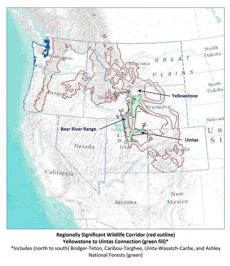
4

These departures are attributed to past fire suppression, timber harvest, drought, and livestock
grazing. Generally, the stated purpose of these proposed projects is to improve big game
habitat, reduce conifer encroachment in aspen and manage hazardous fuel accumulations.8 9

None of these projects propose to halt or reduce the activities that they claim to be causing these
departures from historic or natural conditions, or that affect wildlife. They do not propose to
limit timber harvest. They do not propose to terminate or reduce livestock grazing. They do
not propose to close and restore roads to a natural state to achieve security habitat and
connectivity for wildlife. They also do not acknowledge the inability of fuels treatments to
moderate severe fires as these are climate driven events. They do not propose to limit their
logging, thinning and fuels reductions to areas immediately around structures as the science
recommends, but instead propose to treat millions of acres remote from structures. A recent
article pointed out that this "Active Forest Management" or "Restoration" is a ruse to promote
logging and deflect around the science. 10 In that article, the author cites a 2018 letter to
Congress from more than 200 scientists refuting the current proposed solutions to wildfire such
as forest thinning. Thinning, by removing large trees opens the canopy, leads to drying of the
understory, and increases fire spread by increased wind velocity and increased flammability of
understory vegetation. It also reduces carbon stored in the forests.

These activities currently occurring on our National Forests are perpetuated by misinformation,
rather than science and are counter to the goals of the Executive Order. The example below
illustrates one wildlife corridor and the damage to habitats and carbon storage from livestock
grazing and other activities occurring on the National Forests comprising that corridor.

The Yellowstone to Uintas Connection

The Yellowstone to Uintas Connection is the high elevation wildlife corridor in southwest
Wyoming, southeast Idaho and northeast Utah connecting the Greater Yellowstone Ecosystem
and Northern Rockies to the High Uintas Wilderness and Southern Rockies. The Corridor
includes portions of several National Forests, including the Ashley, Bridger-Teton, Caribou-
Targhee, and Uinta-Wasatch-Cache. It is a critical link in the larger Regionally Significant
Wildlife Corridor designated by the Forest Service.11 In the past, Canada lynx, wolverine,
grizzly bears, and other wildlife used this corridor and the associated core areas such as the
High Uintas Wilderness. Today, these animals are absent from much of this former range.

8
  USDA Forest Service. 2020. Caribou Prescribed Fire Restoration Project. Scoping Proposed Action.
Caribou-Targhee National Forest.
9 USDA Forest Service. 2020. Targhee Prescribed Fire Restoration Project. Scoping Proposed Action.

Caribou-Targhee National Forest.
10 Wuerthner, G. 2021. The Active Forest Management Scam. Counterpunch March 18, 2021.

11 USDA Forest Service. 2003. Regionally Significant Wildlife Corridor. Wasatch-Cache National Forest

2003 Revised Forest Plan and Final Environmental Impact Statement.
5

The Yellowstone to Uintas Connection is fragmented, degraded, and made non-functional for
these animals and other native wildlife by a variety of human activities. Road densities exceed
levels these animals can tolerate. Roads fragment the habitat and intrude even into areas
designated as Inventoried Roadless Areas (IRA). In Idaho, these IRAs are divided into
prescriptions that allow extractive uses and are degraded by user-created roads, timber harvest,
and sold off or traded for mining facilities. 12 Phosphate mines and mountain top removal,
pipelines, roads, transmission lines, and timber harvest further fragment and destroy the
habitat.13

Noise and disturbance from mining, recreational vehicles such as ATVs, dirt bikes and side by
sides drown out natures' sounds in spring, summer and fall while in winter, groomed
snowmobile trails dissect the mountains. Thus enabled, snowmobilers leave no place secure
from their noise and disturbance as they "high mark" remote slopes, many carry guns to kill
wolves, coyotes and other carnivores, or "coyote whack", a term used to describe chasing down
and running over coyotes with their machines. They can scout a hundred miles of groomed
trails in a day looking for mountain lion tracks so they can turn their dogs loose, chase down
and tree the lion and kill it. An example is the Caribou National Forest in Idaho where 97% of
the Forest is open to snowmobiles, including IRAs.14

Finally, the habitat degradation and fragmentation is made complete by the livestock grazing
the Forest Service permits across the landscape. Entire Forests in the West are divided into
grazing allotments with fences, water troughs, pipelines, herders with guns to kill any bear,
wolf, coyote or other carnivore they see "harassing" livestock. States are also doing their best to
eliminate carnivores. For example, Idaho is now proposing no limits on killing mountain
lions.15

The Forest Service does not address the activities fragmenting the corridor. At best, they will
claim that animals will travel around the periphery of a project and use other habitat.16 That
other habitat is not analyzed for its functionality for any species whether it is deer, elk, sage
grouse, lynx. wolverine or others. Population data is not kept current, so impacts are not
documented.

12 USDA Forest Service. 2008. Roadless Area Conservation National Forest System Lands in Idaho. Final
Environmental Impact Statement Appendix C - Idaho Roadless Areas.
13 Carter, J. 2019. Surface Mining in the Yellowstone to Uintas Connection: What About Wildlife?

Counterpunch April 5, 2019.
14 USDA Forest Service. 2003. Final Environmental Impact Statement for the Caribou National Forest

Revised Forest Plan. Volume IV.
15 Idaho Department of Fish and Game. 2021. Big Game Season Setting.

16 U.S. Department of Interior and USDA Forest Service. 2019. Final Environmental Impact Statement

Proposed Dairy Syncline Mine and Reclamation Plan. Bureau of Land Management and Forest Service.
Pocatello, ID.
6

                     Regionally Significant Wildlife Corridor (red outline)
                        Yellowstone to Uintas Connection (green fill)*
*Includes (north to south) Bridger-Teton, Caribou-Targhee, Uinta-Wasatch-Cache and Ashley
National Forests. Map by John Carter.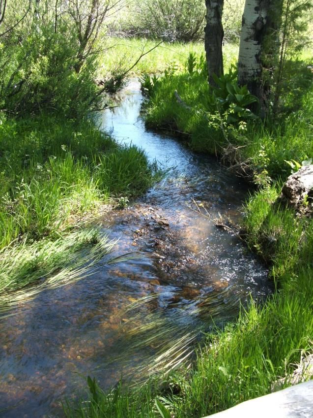
7

The Bear River Range

The Bear River Range in
the Caribou-Targhee and
Wasatch-Cache National
Forests in SE Idaho and NE
Utah is a critical part of the
Yellowstone to Uintas
Connection. It is the place
where the last grizzly bear,
Old Ephraim, was killed in
1923 near Logan, Utah.
You will not find grizzly
bears here today.17

The Bear River Range also
has all the problems with
habitat fragmentation by roads and extractive
uses described above for the corridor overall.
Even the Caribou National Forest Revised Forest
Plan in its FEIS (referenced above) admitted that
road densities are excessive in the Bear River
Range, yet they do not address this problem,
instead they expand roads with each additional
project, while user-created roads and trails
continue to proliferate.

We have studied the Bear River Range over the
decades as it was where we first became aware of
the ecological damage inflicted by livestock
(sheep and cattle) permitted to graze on our                 Aspen stands in the Bear River Range have
                                                             lost their understory vegetation, soils are
National Forests. The Forest Service deflects
                                                             bare and weeds increasing in these cattle
around the damage due to political pressure and
                                                             and sheep grazed aspen stands. The stand in
inherent conflicts.18 19 They conflate livestock
                                                             the lower photo is being lost with only a
with elk and deer by using the term, "ungulates"             handful of trees left. Photos by John Carter.
to describe them while it is the cattle and sheep

17
   Arave, L. Old Ephraim: Utah's most legendary bear. Standard-Examiner. Ogden, Utah. July 16, 2015.
18
   Hudak, M. 2013. Western Turf Wars The Politics of Public Lands Ranching. Biome Books, Binghamton, New
York. 416p
19
   Keetcham, C. 2019. This Land: How Cowboys, Capitalism, and Corruption are Ruining the American West. Viking
Press, New York. 432 p.
8

that are the major consumers
of plants and browsers of
aspen shoots.20 Streams with
barren banks are polluted
with E. coli, sediment, and
manure. Aspen stands lack
recruitment, their
understories are reduced to
bare dirt and they eventually
die off, or they are dominated
by conifers as the grazing
promotes accelerated conifer
recruitment by eliminating
the grasses, flowers and
aspen that would provide
ground cover and
competition for conifer
seedlings.
                                    Aspen stand on Kiesha's Preserve in the Bear River Range, where
                                    livestock have been excluded. This stand has complete ground cover,
Beginning in the 1980's and in      a healthy herbaceous plant community and is regenerating after
the years since, we have            livestock were removed years earlier. Photo by John Carter.
documented the problems in
this mountain range and its
habitat from livestock grazing and logging. In the 1990's the Forest Service was assessing
conditions in Region 4 National Forests, which includes the Bear River Range. At the time, they
acknowledged that vegetation and habitat had suffered large departures from potential
conditions for aspen, conifer, sagebrush/grasslands, riparian and wetland areas. They found
livestock grazing and past timber harvest were a fundamental cause leading to these
departures, yet we saw no effort to address these causes as these practices have continued. As a
result, we began to characterize and report on the impacts.21

Using the Forest Service characteristics that defined healthy vegetation communities such as
forest structural stages and understory plant communities, in 2001 we assessed 310 locations in
livestock-accessible areas in the Idaho portion of the Bear River Range. These were generally
within one mile of water sources and in areas with less than 30% slope, considered "capable" for
livestock. At each location we applied Forest Service criteria for Proper Functioning Condition
(PFC) of the plant communities and habitats. Of these, only 53, or 17% were properly
functioning.

20 Ratner, J.R., E.M. Molvar, T.K. Meek, and J.G. Carter. 2019. What’s eating the Pando Clone? Two weeks
of cattle grazing decimates the understory of Pando and adjacent aspen groves. Hailey, ID: Western
Watersheds Project, 33 pp.
21 Chard, B., Chard, J., and J. Carter. 2002. Assessment of Habitat Conditions Bear River Range Caribou

National Forest, Idaho.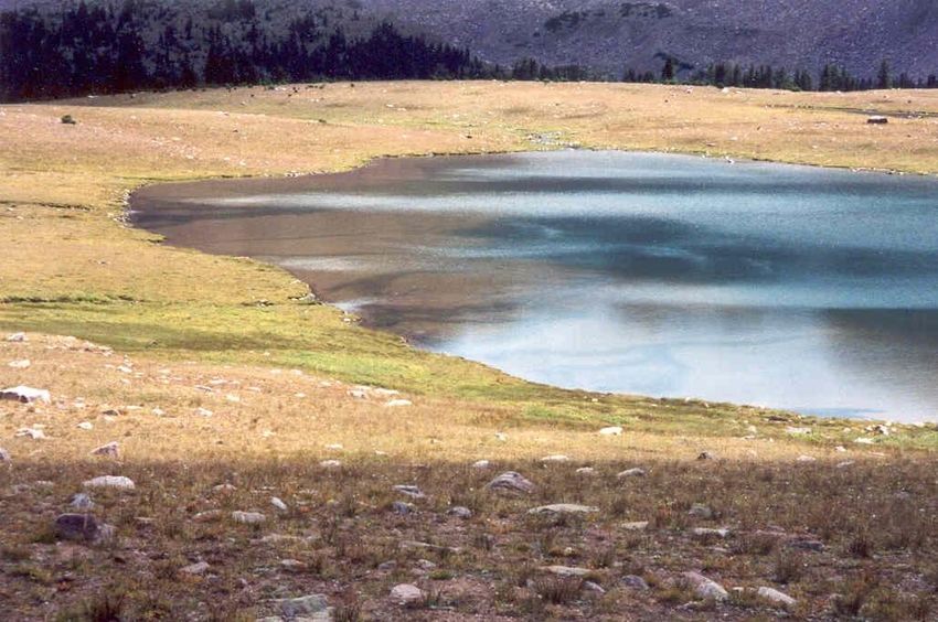
9

Upper and right photos of a grazed riparian
area in the Bear River Range - soils are
barren, there is no stream shading from
shrubs or trees, only weeds survive, and the
streambed is covered in sediment. At left is
a recovering riparian area on Kiesha's
Preserve in the Bear River Range where
livestock were removed years earlier. This
stream has a complete cover of grasses and
flowers, clean substrate and shading from
trees and shrubs. Upper photos by Brandon
Chard. Lower photo by John Carter.
10

       Results of Bear River Range PFC Assessments
            Habitat type         Number of     Number in PFC                   Percent in PFC
                                  locations
       Aspen forest                  71            17                                24%
       Conifer forest                68            14                                21%
       Forb meadow                   44             2                                4.5%
       Sage – grass                  73             8                                11%
       Riparian                      54            12                                22%

We measured habitat structure and ground cover (vegetation, litter, rocks, mosses) at 55
locations in forest openings in sagebrush/grasslands and tall forb communities, finding that
bare soil was dominant, averaging over 50%. Potential ground cover is over 90% and in most
habitats near 100%. In the Utah portion of the Bear River Range, we conducted additional
surveys over time. We compared ground cover in locations grazed by livestock and protected
areas that were not grazed by livestock. Ground cover was less than 50% in those areas grazed
by cattle or sheep. When we grouped the sites by management type, forested areas that were
logged and grazed had only 60% ground cover, while forest openings in sagebrush/grassland
were lowest at 40% ground cover. Ground cover in un-grazed controls was over 90%. In the
logged and grazed areas, woody debris made up the difference. This loss of ground cover has
implications for watersheds in that greater bare soil leads to accelerated erosion, loss of
infiltration and ground water recharge, more rapid runoff and flooding, and stream flow
depletion in summer. With these losses come reductions in stored carbon.

These allotments all contained large numbers of stock ponds and water troughs for livestock, a
proposition the Forest Service promotes time after time as a solution to overgrazing, rather than
reducing stocking rates. In one allotment alone, there were 130 stock ponds and water troughs,
and these are the degraded conditions we found. These water developments for livestock did
not improve conditions, but instead spread the degradation to areas that might have been
spared. We looked further at the impacts of these water sources by sampling areas at different
distances from the water source, finding that sites closer to water were more heavily grazed
(less ground cover) and had lower soil carbon, nitrogen and reduced litter depth when
compared to sites with lesser or no grazing. The grazed sites also had lost most of the
mycorrhizal fungi layer which is fundamental to nutrient cycling.22

22Carter, J., Chard, B., and J. Chard. 2011. Moderating livestock grazing effects on plant productivity,
nitrogen and carbon storage. In Monaco, T.A. et al. comps. 2011. Proceedings – Threats to Shrubland
Ecosystem Integrity; 2010 May 18-20; Logan, UT. Natural Resources and Environmental Issues, Volume
XVII. S.J. and Jessie E. Quinney Natural Resources Research Library, Logan Utah, USA.
11
Bear River Range - Ground Cover and Soil Properties at Grazed and Ungrazed Sites.
Charts by John Carter.
Conclusions and Recommendations
As pointed out in Attachment 1, 103 million acres of National Forests in the West are grazed by
livestock. Even if active forest management (logging, thinning, prescribed fire) could provide a
benefit relating to reduced intensity of wildfires, the costs to wildlife habitat and carbon storage
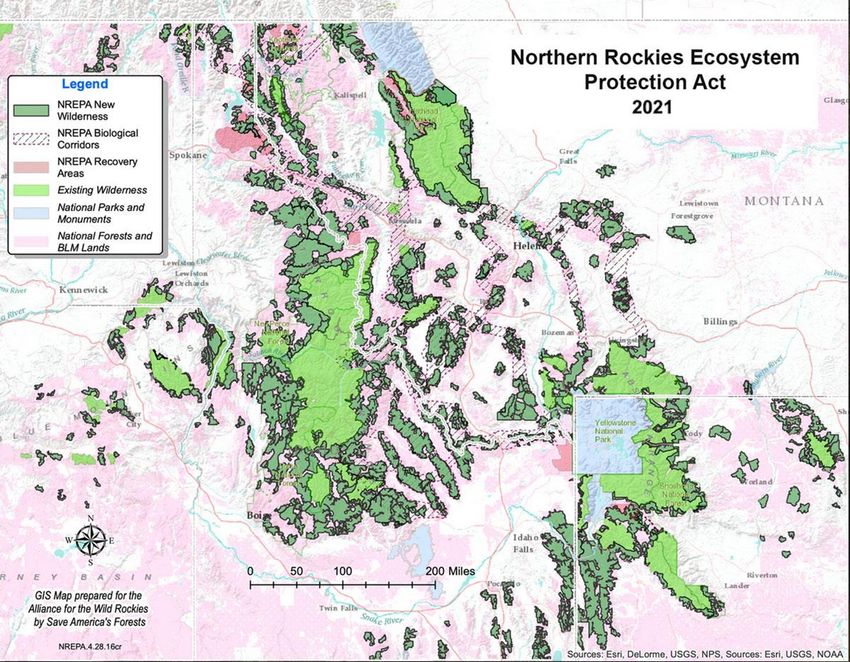
are large. The benefits are also negated if livestock remain and continue to destroy the aspen12 communities, denude and pollute watersheds, streams and springs, and create thickets of conifer saplings. Livestock are grossly overstocked across the public lands in the West. For example, a recent paper demonstrated that stocking rates in the High Uintas Wilderness would need to be reduced by over 90% to be sustainable and minimize environmental damage. 23 In our experience, this is typical across the West. The Forest Service continues business as usual and is budget-driven to propose projects such as the 2,000,000 acres of prescribed fire restoration projects in the Yellowstone to Uintas Connection corridor because they can fit into the wildfire program.24 Across the country, logging and thinning continue to be a major emphasis.25 This fire-driven set of priorities must change if we are to "protect" and restore these lands for the purposes of the Executive Order. The Forest Service and other agencies such as the Bureau of Land Management must recognize the contribution of timber harvest and livestock grazing to loss of carbon storage in plant communities and soils, increased carbon emissions, degradation of wildlife habitat and loss of biodiversity. It is important to eliminate from consideration as "protected" those lands that are grazed by livestock due to their negative effects on these goals. Agencies must delineate, protect and restore wildlife migration corridors. Snowmobile access must be limited and excluded from areas needed for sensitive wildlife species such as Canada lynx, grizzly bears, and wolverine. These agencies must act to reduce road density with its associated motorized recreation and carbon pollution, and greatly reduce or eliminate livestock grazing thru permit action and mechanisms such as voluntary permit retirement and buyouts. In addition, a reduction in commercial timber sales, a diameter limit on logging, protection and restoration of old growth, and a banning of politically derived timber mandates are steps to take to maximize carbon storage and biodiversity. Until this happens, Forest Service and other Public Lands will remain in the lowest protection status while continuing to exacerbate climate change by loss of carbon storage and increases in carbon pollution, accompanied by ongoing losses in biodiversity. An example of a proposal that would protect 23,000,000 acres in the Northern Rockies is the Northern Rockies Ecosystem Protection Act (NREPA). This Act has been introduced in Congress and would protect all the remaining roadless lands in the Northern Rockies. The purpose of the Act is "To designate certain National Forest System lands and certain public lands under the jurisdiction of the Secretary of the Interior in the States of Idaho, Montana, Oregon, Washington, and Wyoming as wilderness, wild and scenic rivers, wildland recovery areas, and biological connecting corridors, and for other purposes."26 It would designate current 23 Carter, J., Vasquez, E. and Jones, A. (2020) Spatial Analysis of Livestock Grazing and Forest Service Management in the High Uintas Wilderness, Utah. Journal of Geographic Information System, 12, 45-69. https://doi.org/10.4236/jgis.2020.122003 24 USDA Forest Service. 2020. FY 2021 Budget Justification. 25 Mounger, D. 2021. Restoration, Resiliency, and Regeneration Follies n the Central Hardwood Region. Tennesee Heartwood. Powerpoint Presentation. https://app.box.com/s/fpyn1q5l68im45e0jguwv62ftzmz9d17 26 https://www.congress.gov/bill/117th-congress/house-bill/1755
13

Inventoried Roadless Areas as wilderness and protect 1,800 miles of rivers under the Wild and
Scenic Rivers Act. It would remove thousands of miles of roads used for past logging and other
purposes that fragment the landscape and restore natural conditions.27

NREPA would partially meet the goals of the Executive Order and Forest Service Roadmap for
Climate Change to provide for protection, restoration, carbon sequestration, biodiversity and
habitat connectivity. Expanding this to include reductions in livestock grazing, timber harvest
and vegetation manipulations across the 103 million acres of National Forest and 165 million
acres of BLM managed land in the West would begin to restore the native plant communities,
watersheds, streams and wetlands, and wildlife habitat to their potential natural condition.
Along with this, a necessary step is removal of livestock infrastructure such as fences that
fragment habitat and water diversions that dry up streams and springs. Halting the
killing/removal of native sagebrush and junipers to benefit livestock would allow species such
as sage grouse and migrant birds to begin recovery.

   Map of the extent of lands proposed in the Northern Rockies Ecosystem Protection Act in Idaho,
   Montana, Wyoming, Washington and Oregon. Map provided by the Alliance for the Wild Rockies.
27 https://allianceforthewildrockies.org/nrepa/
14

                                              Attachment 1

This summary of pertinent literature is intended to provide context to the issues addressed in
the accompanying comments to the Climate Task Force on protecting 30% of the lands and
waters by 2030 as outlined in the January 27, 2021 Executive Order on Tackling the Climate
Crisis. Topics covered include:

    1.   Livestock Grazing and Carbon Storage
    2.   Livestock Grazing and Biodiversity
    3.   Forests and Carbon Storage
    4.   Wildfire and Species Effects
    5.   Wildfire and Insect Outbreaks
    6.   Fire Suppression and Fuel Buildup
    7.   Summaries of Issues Around Fire
    8.   Road Densities and Effects
    9.   Off Road Vehicles and Carbon Emissions

Livestock Grazing and Carbon Storage

A goal of the January 27, 2021 Executive Order is to determine the characteristics of "protected"
or "conserved" lands for the purpose of reducing or reversing carbon loss for mitigating climate
change, providing species protections for biodiversity, and restoring biological corridors.
Corridors are essential to effect climate-induced animal or plant migration. It is important to
eliminate from consideration those lands that are grazed by livestock due to their negative
effects on these goals.

The Intergovernmental Panel on Climate Change (IPCC) released its special report on climate
change in August 2019.1 That report noted that, "reducing deforestation and forest degradation
rates represents one of the most effective and robust options for climate change mitigation, with
large mitigation benefits globally." The Food and Agriculture Organization (FAO) estimated
total global emissions of greenhouse gases (GHG) from livestock are 7.1 Gigatons of CO2
equivalent, or 14.5% of all human related GHG emissions. An estimated 44% of these emissions
are methane, 29% Nitrous Oxide, and 27% carbon dioxide. This is 5% of global anthropogenic
CO2 emissions, 44% of methane emissions, and 53% of nitrous oxide emissions.2 In a prior

1 IPCC. 2019. Climate Change and Land: an IPCC special report on climate change, desertification, land
degradation, sustainable land management, food security, and greenhouse gas fluxes in terrestrial
ecosystems. https://www.ipcc.ch/report/srccl/. Accessed 11/23/2019.
2 Gerber, P.J., Steinfeld, H., Henderson, B., Mottet, A., Opio, C., Dijkman, J., Falcucci, A. & Tempio, G.

2013. Tackling climate change through livestock – A global assessment of emissions and mitigation
opportunities. Food and Agriculture Organization of the United Nations (FAO), Rome.
http://www.fao.org/news/story/en/item/197623/icode/ Accessed 03/28/2021.
15 study, FAO estimated the GHG emissions from livestock production was more than that of all transportation and industry sources. 3 Three times as much carbon resides in soil organic matter as in the atmosphere, while grasslands and shrublands have been estimated to store 30 percent of the world’s soil carbon with additional amounts stored in the associated vegetation. 4 5 Long term intensive agriculture can significantly deplete soil organic carbon and past livestock grazing in the United States has led to such losses. 6 7 8 The United Nations Convention to Combat Desertification has estimated that 73 percent of livestock-grazed lands worldwide have suffered soil degradation.9 The literature regarding grazing effects upon carbon storage varies, in part because diverse ecosystems may respond differently to grazing animals. For instance, livestock grazing was found to significantly reduce carbon storage on Australian grazed lands while destocking currently grazed shrublands resulted in net carbon storage. 10 Livestock-grazed sites in Canyonlands National Park, Utah had 20% less plant cover and 100% less soil carbon and nitrogen than areas grazed only by native herbivores.11 In a study of livestock grazing effects in the Wasatch Cache National Forest in NE Utah, there were declines in soil carbon and nitrogen in livestock grazed areas compared to ungrazed areas. As grazing intensity increased, ground cover, plant litter, soil organic carbon and nitrogen decreased. 12 Analysis of livestock grazing in the High Uintas Wilderness demonstrated that the Forest Service grossly overstocked this 3 Steinfeld H., Gerber, P., Wassentaar, T., Castel, V., Rosales, M. & de Haan, C. 2006. Livestock’s long shadow. Rome, Italy. Food and Agriculture Organization of the United Nations. 407 p. 4 Almaras, R. R., H. H. Schomberg, and C. L. Douglas. 2000. Soil organic carbon sequestration potential of adopting conservation tillage in U.S. croplands. Journal of Soil and Water Conservation 55:365-373. 5 Grace, J., San Jose, J., Meir, P., Miranda, H. and Montes, R. 2006. Productivity and carbon fluxes of tropical savannas. Journal of Biogeography 33: 387–400. 6 Benbi, D. K. and J. S. Brar. 2009. A 25-year record of carbon sequestration and soil properties in intensive agriculture. Agronomy for Sustainable Development 29:257-265. 7 Follett, R. F., J. M. Kimble, and R. Lal [eds.]. 2001. The potential of U.S. grazing lands to sequester carbon and mitigate the greenhouse effect. Boca Raton, FL, USA: Lewis Publishers. 457p. 8 eely, C., S. Bunning, and A. Wilkes. 2009. Review of evidence on drylands pastoral systems and climate change: Implications and opportunities for mitigation and adaptation. Rome, Italy: Food and Agriculture Organization of the United Nations. Land and Water Discussion Paper 8. 48 p. 9 Gabathuler E., H. Liniger, C. Hauert, and M. Giger. 2009. Benefits of sustainable land management. Bern, Switzerland: World Overview of Conservation Approaches and Technologies, Center for Development and Environment, University of Bern. 15 p. 10 Daryanto, S. D.J. Eldridge, and H.L. Throop. 2013. Managing semi-arid woodlands for carbon storage: Grazing and shrub effects on above and belowground carbon. Agriculture, Ecosystems and Environment 169:1– 11. 11 Fernandez, D.P., J.C. Neff and R.L. Reynolds. 2008. Biogeochemical and ecological impacts of livestock grazing in semi-arid southeastern Utah, USA. Journal of Arid Environments 72: 777–791. 12 Carter, J., B.Chard and J.Chard. 2011. Moderating livestock grazing effects on plant productivity, carbon and nitrogen storage. In: Monaco, T.A. et al. [eds.]. Proceedings of the 17th Wildland Shrub Symposium: 18-20 May 2010: Logan, UT, USA. p191-205.
16

Upper - Lake in High Uintas Wilderness grazed by livestock leading to
barren, eroding soil, loss of vegetation and rapid filling of the lake with
sediment. Lower - Stream and wetlands in an ungrazed watershed in the
High Uintas Wilderness have complete soil cover, and a healthy and
productive vegetation community. Photos by John Carter
17

160,410 acre area by including areas that are not capable for grazing livestock, such as steep
slopes, forested areas and highly erodible soils. When current forage production, current forage
consumption rates for livestock and a conservative utilization factor were used to determine the
amount of forage that could be allocated to livestock, it was determined that the stocking rate
should be reduced by over 90% to be sustainable.13

Livestock Grazing and Biodiversity

In 16 western states in the US, 165 million acres on Bureau of Land Management-managed land
(94%) and 103 million acres of Forest Service-managed land are grazed by livestock. Seventy
percent of the western US is grazed by livestock. This includes these BLM and Forest Service
managed areas as well as wildlife refuges, wilderness areas, national monuments and national
parks. These grazed lands have suffered severe impacts leading to loss of biodiversity, lowered
population numbers of species, disrupted ecosystem function and altered terrestrial and aquatic
habitats. 14 The resulting simplified plant communities with the associated loss of vegetation
mosaics negatively affect pollinators, birds, small mammals, amphibians, wild ungulates, and
other native wildlife, as well as rare species such as Western sage-grouse. 15 A meta-analysis of
109 global studies that looked at the response of animals or plants to livestock grazing relative
to livestock exclusion showed that "Across all animals, livestock exclusion increased abundance
and diversity, but these effects were greatest for trophic levels directly dependent on plants,
such as herbivores and pollinators.16 Other studies have documented increased riparian
songbird abundance after livestock exclusion. 17 18 Overall biodiversity increased under long
term rest from livestock grazing. 19 20

13 Carter, J., Vasquez, E. and Jones, A. (2020) Spatial Analysis of Livestock Grazing and Forest Service
Management in the High Uintas Wilderness, Utah. Journal of Geographic Information System, 12, 45-69.
https://doi.org/10.4236/jgis.2020.122003
14 Fleischner, T. 1994. Ecological costs of livestock grazing in western North America. Conservation

Biology 8(3):629-644.
15 Beschta, R.L., D.L. Donahue, .A. DellaSala, J.J. Rhodes, J.R. Karr, M.H. O’Brien, T.L. Fleischner, and C.D.

Williams. 2012. Adapting to climate change on western public lands: addressing the ecological effects of
domestic, wild, and feral ungulates. Environmental Management DOI 10.1007/s00267-012-9964-9. 18p.
16 Filazzola,A., Brwn, C., Dettlaff, M.A., Batbaatar, A., Grenke,J.,Bao, T., Heida, I.P., and Cahill, J.F. 2020.

The effects of livestock grazing on biodivesity are multi-trophic: a meta-analysis. Ecology Letters 23:1298
- 1309. doi: 10.1111/ele.13527
17 Dobkin, D. S., A. C. Rich, and W. H. Pyle. 1998. Habitat and avifaunal recovery from livestock grazing

in a riparian meadow system of the northwestern Great Basin. Conservation Biology 12: 209-221.
18 Earnst, S.L., Ballard, J.A., Dobkin, D.S., 2005, Riparian songbird abundance a decade after cattle

removal on Hart Mountain and Sheldon National Wildlife Refuges In: Ralph, C.J., Rich, T. [eds.],
Proceedings of the Third International Partners in Flight Conference; Albany, CA, USA. US Department
of Agriculture. Forest Service, General Technical Report PSW-GTR-191. p. 550-558.
19 Bock, C.E., J.H. Bock, W.R. Penney, and V.M. Hawthorne. 1984. Responses of birds, rodents, and

vegetation to livestock exclosure in a semidesert grassland site. Journal of Range Management 37:239-242
20 Brady, W.W., M.R. Stromberg, E.F. Aldon, C.D. Bonham, and S.H. Henry. 1989. Response of a

semidesert grassland to 16 years of rest from grazing. Journal of Range Management 42:284-288.
18

Forests and Carbon Storage

Forests currently capture and store approximately 25% of global anthropogenic carbon
emissions. Forests in the lower 48 states sequester 460 ± 48 Teragrams (Tg) of carbon per year,
while losses from disturbance average 191 ± 10 Tg carbon per year. Carbon loss in the
southern US was 105 ± 6 Tg with 92% from harvest and 5% from wind damage. Carbon loss in
the western US was 44 ± 3 Tg with 66% due to harvest, 15% from fire, and 13% from insect
damage. Carbon loss in the northern US was 41 ± 2 Tg with 86% from harvest, 9% from insect
damage, and 3% from land conversion. Taken together, these disturbances reduced the
estimated potential carbon sink of US forests by 42%.21 Life cycle analyses of fuel reduction
treatments including removal of woody biomass, combustion of fuel in logging machinery,
transport, burning of slash, milling energy use, and other factors lead to the conclusion that
over the long term, carbon losses from treatment projects may exceed those from wildfire
because most of the carbon mass remains on site unburned during fire. The authors further
noted that, “Studies at large spatial and temporal scales suggest that there is a low likelihood
of high-severity wildfire events interacting with treated forests, negating any expected benefit
from fuels reduction.”22

A USDA study estimated soil organic carbon in relatively undisturbed secondary forests in the
Rocky Mountain Region is 71,571 lbs/acre. Estimated carbon in dead organic matter above the
mineral soil horizon in lodgepole pine forest in the Rocky Mountain Region is 13,411 lb/acre.
Average storage of carbon by Forest ecosystem component for the Rocky Mountain Region is
148,190 lb/acre for Idaho with trees (60,961 lb/acre), soil (64,417 lb/acre), forest floor (21,735
lb/acre) and understory (1,077 lb/acre). Annual average carbon accumulation in live trees for
Idaho is 1,112 lb/acre/year. 23 The Proceedings of the American Society of Mining and
Reclamation reported that, "Soil organic matter (OM) is drastically reduced by various
processes (erosion, leaching, decomposition, dilution through soil horizon mixing etc.)
typically associated with topsoil salvage prior to surface mining activities. Of these processes,
loss of physical protection of OM through the breaking up of soil aggregation can result in up
to 65% of soil carbon (C) reductions."24 This has implications for timber harvest, or other
activities that disturb and disrupt the soil.

21 Harris, N.L., Hagen, S.C., Saatchi, S.S. et al. Attribution of net carbon change by disturbance type across
forest lands of the conterminous United States. Carbon Balance Manage 11, 24 (2016).
https://doi.org/10.1186/s13021-016-0066-5
22 Restaino, J.C. and D.L. Peterson. 2013. Wildfire and fuel treatments effects on forest carbon dynamics in

the western United States. Forest Ecology and Management 303:46-60.
23 Birdsey, R. A. Carbon Storage and Accumulation in United States Forest Ecosystems. USDA Forest

Service General Technical Report WO-59.
24 Wick et al. 2008. Soil aggregate and aggregate associated carbon recovery in short-term stockpiles.

Proceedings America Society of Mining and Reclamation, 2008 pp 1389-1412. DOI:
10.21000/JASMR08011389
19

Both fuel treatments and wildfire remove carbon from forests. In mature ponderosa pine
forests, for example, protecting one unit of carbon from wildfire combustion came at a cost of
removing three units of carbon with treatments. "The reason for this is simple: the efficacy of
fuel reduction treatments in reducing future wildfire emissions comes in large part by
removing or combusting surface fuels ahead of time. Furthermore, because removing fine
canopy fuels (i.e. leaves and twigs) practically necessitates removing the branches and boles to
which they are attached, conventional fuel-reduction treatments usually remove more carbon
from a forest stand than would a wildfire burning in an untreated stand." The analysis showed
that thinning and other fuel treatments to reduce high-severity fire, although considered to
keep carbon sequestered, do not do so. High carbon losses came from treatments while only
small losses were associated with high-severity fire. These were similar to the losses with low-
severity fire that treatments are meant to encourage.25

Wildfire and Species Effects

More species (48% of the community) reached peak abundance at moderate-high-severity-fire
locations than at low-severity fire (8%), silvicultural management (16%), or undisturbed (13%)
locations. Total community abundance was highest in undisturbed dense forests as well as in
the first few years after silvicultural management and lowest in the first few years after
moderate-high-severity fire, then abundance in all types of disturbed habitats was similar by 10
years after disturbance. Even though the total community abundance was relatively low in
moderate-high-severity-fire habitats, species diversity was the highest. Moderate-high-severity
fire supported a unique portion of the avian community, while low-severity fire and
silvicultural management were relatively similar.26

25 Campbell, J.L., Harmon, M.E., and S.R. Mitchell. 2012. Can fuel-reduction treatments really increase
forest carbon storage in the western US by reducing future fire emissions? Frontiers in Ecology and
Environment 10(2):83-90. doi:10.1890/110057.
26 Roberts, L.J.; Burnett, R.; Fogg, A. Fire and Mechanical Forest Management Treatments Support

Different Portions of the Bird Community in Fire-Suppressed Forests. Forests 2021, 12, 150.
https://doi.org/10.3390/f12020150
20

Clearcuts in the Helena NF (upper) and Gallatin NF (lower) result in
habitat fragmentation and loss of carbon storage. Photos by George
Wuerthner.
21

Thinning projects in the Deschutes NF result in soil disturbance, loss of habitat and loss
of carbon storage. Photos by George Wuerthner.
22

Old growth mixed conifer forests in the Caribou NF have habitat structure,
healthy and diverse understory habitat and provide maximum carbon storage.

Photos by John Carter
23

Wildfire and Insect Outbreaks

An analysis of 2766 large wildfires that burned in the west during the 2003 - 2012 period was
carried out to determine the influence of mountain pine beetle outbreaks on fire behavior and
area burned. Approximately 12% of these fires intersected prior beetle outbreaks and burned in
those areas for only about 4 days. Daily area burned for high-extreme fire behavior in large
fires burning for long periods in landscapes affected by mountain pine beetles was not related
to beetle activity, but was due to warm, dry and windy conditions.27 A study of the effects of
spruce beetle on fire activity in Colorado found no effect of pre-fire beetle activity on fire
severity. Both bark beetle outbreaks and wildfires have increased due to climate variability
while topography, weather conditions and pre-outbreak basal area exerted a stronger effect on
fire severity. 28 Review of treatments (tree harvest and prescribed burning, among other actions)
for mountain pine beetle control found that overall, they had little to no impact on mountain
pine beetle. Controls that had not been logged or thinned had more trees killed by beetles, but
in the end, contained more residual mature trees than did thinned stands.29

Fire Suppression and Fuel Buildup

Fire suppression and the associated fuel buildup is often blamed for the larger wildfires in
recent years. The solution proposed nearly always is for more logging and thinning, or fuel
treatments. But this does not apply to most fires and plant communities in the West. For
example, about half the 20,000,000 acres burned in California in 2020 were in chapparal or
grassland, not forests, while about 35% were in conifer forests. There is also a difference in fire
intervals depending on whether the forest is a dry conifer forest. These make up only about 4%
of forest types in western Montana and northern Idaho and are subject to more frequent fire
return intervals on the order of decades. The higher elevation conifer forests have much longer
fire return intervals of 200 - 300 years. Large fires are the result of drought, high temperatures,
low humidity and wind.30 An analysis of 1500 fires affecting Ponderosa and Jeffrey Pine and
mixed conifer western forests found that "forests with higher levels of protection had lower

27 Hart, Sarah J.; Preston, Daniel L. 2020. Fire weather drives daily area burned and observations of fire
behavior in mountain pine beetle affected landscapes. Environmental Research Letters 15(5):054007.
28 Robert A Andrus, Thomas T Veblen, Brian J Harvey, Sarah J Hart. 2016. Fire severity unaffected by

spruce beetle outbreak in spruce-fir forests in southwestern Colorado. Ecol Appl;26(3):700-11. Doi:
10.1890/15-1121.
29 Six, D.L., Biber,E., and Long, E. 2014. Management for mountain pine beetle outbreak suppression:

Does relevant science support current policy? Forests 5:103-133. doi:10.3390/f5010103
30 Wuerthner, G. 2021. Fire Suppression Hyperbole. The Wildlife News, March 1, 2021.

https://www.thewildlifenews.com/2021/03/01/fire-suppression-hyperbole/
24

severity fire even though they are considered to have the highest levels of biomass and fuel
loads.31

Summaries of Issues Around Fire

The Firefighters United for Safety, Ethics and Ecology have summarized the issues surrounding
fires, logging, fuels treatments, carbon storage and climate change. Some of their points are
that: (1) most forests are fire-adapted and renewed by fire; (2) more acres burned in the past
than today; (3) logging targets commercially valuable trees for harvest and these trees have the
least influence on fire spread; (4) logging does not address fuels such as small diameter ladder
and surface fuels; (5) past logging has made the forest more flammable than the original forest
cover; (6) firefighting efforts are irrelevant against large or high-intensity fires burning under
severe conditions; (7) firefighters are most effective in suppressing small, low-intensity fires that
should not be suppressed; (8) only 15% of total carbon from a tree is preserved in wood
products while most enters the atmosphere from logging and milling and these losses are
greater than from wildfires; (9) most carbon is stored in large tree boles or soils and most severe
wildfires do not completely consume large tree boles or deep layers of organic soils; (10) areas
closest to communities have the legacy of logging and fire exclusion and these areas pose the
greatest fire risk and fuel hazards. They conclude that "attempts to fire-proof the forest through
landscape-scale logging or mechanized firefighting are essentially geoengineering schemes that
would fundamentally alter forest ecosystems, ultimately put them at greater risk of destruction,
and further accelerate global heating."32

A recent book has addressed the value of large trees using Oregon Eastside Forests as an
example.33 The values of large trees include: (1) forest raptors, woodpeckers, songbirds, bats,
and other small mammals depend on large trees to nest, forage, overwinter, roost, and den; (2)
large trees provide shelter and microclimates for countless invertebrates, epiphytes,
herpetofauna, and rare plants; (3) large trees in riparian areas provide stream-side shading and,
when they fall into streams, hiding cover for aquatic species; (4) large trees store the
accumulation of decades to centuries of atmospheric carbon helping to reduce adverse
consequences of global overheating; (5) large trees are essential to nutrient cycling, soil
stabilization, and below-ground processes that develop as they mature; (6) large trees remain in
short supply due to a legacy of logging; (7) when logged, large trees release most (up to two-
thirds) of their stored carbon to the atmosphere (contributing to global overheating) and their
emitted carbon takes decades to centuries to recover, if ever. A current article also reviews the

31 Bradley, C.M., Hanson, C.T., and DellaSala, D.A. 2016. Does increased forest protection correspond to
higher fire severity in frequent fire forests in the western United States? Ecosphere 7(10)/e01492.
https://doi.org/10.1002/ecs2.1492
32 Ingalsbee, T. 2020. Incendiary rhetoric: climate change, wildfire, and ecological fire management.

Firefighters United for Safety, Ethics & Ecology. 24 p. https://fusee.org/fusee/incendiary-rhetoric
33 DellaSala, D.A. and Baker, W.L. 2020. Large Trees: Oregon's Bio-Cultural Legacy Essential to Wildlife,

Clean Water, and Carbon Storage. https://oregonwild.org/sites/default/files/pdf-
files/Large%20Trees%20Report%20resize.pdf
25

value of large trees for carbon storage and notes that live and dead trees and forest soil hold the
equivalent of 80% of all the carbon currently in Earth's atmosphere. 34 They point out that in
mature and old forests in Oregon: "Big trees, with trunks more than 21 inches in diameter, make
up just 3% of these forests but store 42% of the above-ground carbon. Globally, a 2018 study
found that the largest-diameter 1% of trees hold half of all the carbon stored in the world's
forests." This validates the need to protect and restore mature and old-growth forests for their
value in carbon storage.

Another article regarding fire in California addressed these and similar points, citing
supporting science.35 Some of these are that: (1) there is not an unnatural excess of fires in
forests today, in fact, there is less than in the past; (2) current fires are mostly low to moderate
intensity in western US forests; (3) those forests that have remained without fire the longest
have mostly low to moderate intensity fire; (4) high intensity fires do not destroy wildlife
habitat, but create "snag forest" which is comparable to old growth forest in terms of native
biodiversity and wildlife abundance; (5) human-caused climate change increases temperatures
and influences wildland fire; (6) today's forests are not unnaturally dense and overgrown, there
are more small trees and fewer medium and large trees, less overall biomass and therefore less
carbon stored; (7) recent large fires are not unusual and occurred prior to modern fire
suppression; (8) drought and native bark beetles do not make forests unhealthy, during
drought, bark beetles selectively kill the weakest and least climate adapted trees leaving the
better adapted ones to survive and reproduce, while bird and small mammal species increase in
numbers because snags provide excellent wildlife habitat; (9) logging reduces the cooling shade
of forest canopy, creating hotter and drier conditions and leaves behind "kindling-like slash
debris, and spreads combustible weeds; (10) Field studies of large fires find only about 11% of
forest carbon is consumed and only 3% of the carbon is from trees. Vigorous post-fire regrowth
absorbs huge amounts of CO2 from the atmosphere, resulting in an overall net decrease in
atmospheric carbon a decade after fire; and (11) landscape scale prescribed burning would
cause at least a ten-fold increase in smoke emissions relative to current fire levels; (12)
prescribed burns do not stop wildland fire when it occurs but can alter intensity, while the
short-term benefit lasts only about 10 - 20 years so would have to be repeated every 10- 20
years.

In a review36 of wildland fuel treatments in the interior forests of the US, the following points
were made:

34
   Law, B. and Moomaw, W. 2021. Curb climate change the easy way: Don't cut down big trees. Phys.Org April 7,
2021. https://phys.org/news/2021-04-curb-climate-easy-dont-big.html
35 Hanson, C. 2019. Common Myths about Forests and Fire. In: A New Direction for California Wildfire

Policy - Working from the Home Outward. Leonardo DeCaprio Foundation.
36Reinhardt, E.D., Keane, R.E., Calkin, D.E., and J.D. Cohen. 2008. Objectives and considerations for

wildland fuel treatment in forested ecosystems of the interior western United States. Forest Ecology and
Management. 256:1997-2006. https://app.box.com/s/loj3dqgz37akelxs18thq0qpkplmk533
26

(1)     "Treating fuels to reduce fire occurrence, fire size, or amount of burned area is ultimately
both futile and counter-productive" because most acreage burned is under extreme conditions
which make suppression ineffective. If, due to treatments, moderate intensity fires are
suppressed this leads to most acres burning under extreme conditions. Reducing burned area
would not be desirable as large fires were common prior to European settlement and many
western plant species are adapted to large, severe wildfires. Large fires generally have many
areas lightly to moderately burned. Any fire "could offer a unique opportunity to restore fire to
historically fire-dominated landscapes and thereby reduce fuels and subsequent effects."

(2)    Reducing fuel hazard is not the same as ecosystem restoration. Treatments such as
mastication and thinning may leave stand conditions that do not mimic historical conditions.
Mastication breaks, chips, grinds canopy and surface woody material into a "compressed fuel
bed" while thinning that removes fire-adapted species and leaves shade tolerant species do not
mimic historical conditions. "Fire itself can best establish dynamic landscape mosaics that
maintain ecological integrity."

(3)    Thinning for fire hazard reduction should concentrate on the smaller understory trees to
"reduce vertical continuity between surface fuels and the forest canopy." Thinning can increase
surface fire behavior, for example, it increases surface wind speed and results in solar radiation
and drying of the forest floor creating drier surface fuels.

(4)     Fuel treatments are transient. Prescribed fire creates tree mortality with snag fall
contributing to fuel loads, tree crowns expand to fill voids, trees continue to drop litter. Trees
cut for harvest or killed by fire contribute limbs to the forest floor, increasing fuel loadings. Up
to seven treatments may be needed to "return the area to acceptable conditions that mimic some
historical range."

(5)     Fire was historically more complex and everchanging than commonly believed and
cannot be mimicked by prescribed burning. The low-severity model that is being pushed as
“restoration” is no longer widely accepted by scientists. Prescribed fires do not have the
variability of past wildfires, and thus can cannot mimic them.

(6)    Commercial Thinning and Prescribed out of season burning have negative ecological
impacts. Out of season burning coincides with nesting season for birds. Smoke may drive them
from their nest, possibly even kill nestlings, etc. Ground nesters will be most impacted.

(7)    The probability that a fire will encounter a fuel treatment of any kind is low.

Another review questions current policy and whether it is based on science. Lack of monitoring
of post treatment effects leaves questions as to the efficacy of treatments. "While the use of
timber harvests is generally accepted as an effective approach to controlling bark beetles during
outbreaks, there has been a dearth of monitoring to assess outcomes, and failures are often not
reported. Additionally, few studies have focused on how these treatments affect forest structure
You can also read