CREWS INITIATIVE CLIMATE RISK AND EARLY WARNING SYSTEMS - Building Seamless Multi-Hazard Early Warning System - unisdr
←
→
Page content transcription
If your browser does not render page correctly, please read the page content below
CLIMATE RISK AND EARLY WARNING
                    SYSTEMS

                 CREWS INITIATIVE

    !

             Building Seamless Multi-Hazard Early Warning System
                         and Risk Information Capacities
                  with Strengthened International Cooperation

                               September 2015

!
                                                                   !
2) Extreme weather events: Climate-change-related risks from extreme events, such as heat waves, extreme
precipitation, and coastal flooding, are already moderate (high confidence) and high with 1°C additional
warming (medium confidence). Risks associated with some types of extreme events (e.g., extreme heat)
increase further at higher temperatures (high confidence).

                        IPCC, 2014: AR5, ,Adaptation, and Vulnerability, Summary for policymakers Impacts

That’s why I want to call, here in Sendaï, the international community to act to support, as soon as possible,
the deployment of climate risk early warning system in the most vulnerable countries.
(…)
This will require the support for acquiring computers and network to access the data and to diffuse it. This
will also require capacity building to use those dates, and to support the deployment of system to effectively
warn the communities . This effort is realistic, and France is ready to take its part of it.

                                                                                             Laurent Fabius,
                                                                           Foreign Affairs Minister of France
                                                                                  incoming COP21 President
                                                                                               Sendai, Japan
                                                                                             March 14, 2015

To this end, we will:

a) Intensify our support particularly for vulnerable countries’ own efforts to manage climate change related
disaster risk and to build resilience. We will aim to increase by up to 400 million the number of people in the
most vulnerable developing countries who have access to direct or indirect insurance coverage against the
negative impact of climate change related hazards by 2020 and support the development of early warning
systems in the most vulnerable countries. To do so we will learn from and build on already existing risk
insurance facilities such as the African Risk Capacity, the Caribbean Catastrophe Risk Insurance Facility
and other efforts to develop insurance solutions and markets in vulnerable regions, including in small
islands developing states, Africa, Asia and Pacific, Latin America and the Caribbean as set out in the annex.

                                                                                     G-7 Leaders' Declaration
                                                                                     Schloss Elmau, Germany
                                                                                                June 8, 2015

                                                      2                                                   !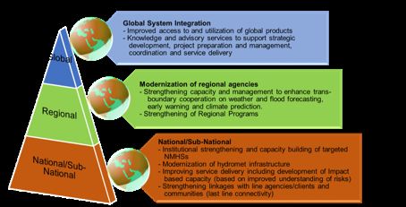
Foreword
    Since the UN World Conference on Disaster Risk Reduction in Sendai, Japan, there have been
many climate events all over the world. We all remember tropical cyclone Pam, which hit Vanuatu in
the middle of the Sendai Conference. I have since learnt that the death toll following Pam was
considerably reduced as a result of an effective early warning system. Since then, there have been
heatwaves in India, with over 2,000 deaths according to media reports, and Pakistan, where the death
toll was also high. Georgia was hit by devastating flooding. And although they receive less media
coverage, many African countries have also experienced extreme climate events. Last April, I travelled
to Tanzania, a few days after the floods which left many dead.
    You do not need me to demonstrate to you the importance of early warning systems in dealing with
our numerous climate events. I am aware that we must be cautious, as it is difficult to link these
extreme events to climate disruption. But like me, you know that the scientists are warning that these
events are merely a foretaste of what could become a disaster scenario for the planet.
    At the Sendai Conference, to enhance discussions on the adopted Framework, France proposed a
simple target: to mobilize the international community to help the most vulnerable countries,
particularly the Small Island Developing States (SIDS) and Least Developed Countries (LDCs), to set
up Climate Risk Early Warning Systems (CREWS). France considers it a responsibility to share our
skills and expertise with the countries most exposed to climate disruption.
    International support for EWS already has a lot of work underway. But we still have a long way to
go, because based on the documents which will be presented later, the LDCs and SIDS currently do
not all have effective early warning systems. In our preparatory work for this meeting, we learnt that
over 80% of the LDCs have only a basic early warning system. In 15 countries, no such system even
exists. In the island states, we found similar figures, with only four or five out of 40 having an
effective system.
    We now know that early warning systems save lives and significantly reduce the economic impact
of disasters. Yet in over half of Africa, there is no weather observation. According to the WMO, 54%
of surface stations and 71% of atmospheric weather stations emit no data.
    It is for this reason that France, in collaboration with Norway, the WMO, UNISDR and the World
Bank/ GFDRR (Global Facility for Disaster Reduction and Recovery), launched this coalition known
as CREWS (Climate Risk Early Warning Systems). The aim is simple: to strengthen and broaden the
work of the international community in supporting early warning systems in vulnerable countries, and
to mobilize additional financing to support and enhance the actions which we are currently
implementing, in order to try to fully cover the global population exposed to extreme climate events
by 2020.
    The aim of this initiative is not to create a new institution, but mainly to have an operational
objective. I have a deep respect for the people who have been working on these issues for many years,
such as the WMO with Michel Jarraud, who was behind this idea, Margareta Wahlström’s teams at the
UNISDR who have been providing daily coordination for the risk prevention community, and the
World Bank and Rachel Kytes’ teams, which, through the Global Facility for Disaster Reduction and
Recovery (GFDRR), have developed many programmes to strengthen weather infrastructure. I would
also like to commend the work carried out by Norway on the Global Framework for Climate Services,
which has mobilized the international community around a series of activities, ranging from early
warning systems to modelling climate change.
    France’s aim in this initiative is use COP21 as an opportunity to mobilize the international
community to meet the needs of the most vulnerable countries. Such countries have made adaptation a
priority. And yet without weather information, without early warning systems, adaptation cannot be
considered. How can farmers in the Sahel have access to insurance if the risks are unknown and there

                                                  3                                                  !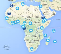
are no early warning systems? How can investors commit to financing a project in a region vulnerable
to cyclones if they are not confident that they will be warned in the event of a storm?
    We now have a clear picture of the needs. Now it is time to meet them. This is why France has
proposed that CREWS be a coalition based around a trust fund – I will return to this point – hosted by
the GFDRR, and with a light secretariat, based in Geneva at the WMO and UNISDR, so that this
coalition can acquire the means to achieve its ambitions.
    The aim is to mobilize contributions to fill in the gaps, to enable the actors on the ground at
regional, national and local level to have the best possible working conditions. In this way,
populations, who nowadays nearly all own mobile phones and other modern communication devices,
can be alerted to an impending climate disaster before it occurs.
    So where do we stand at the moment?
    First, the needs. We have a reasonably clear idea of what must be done. All partners have worked
together to identify the actions to be carried out. They will be presented to you in detail this afternoon,
and must be fine-tuned by September in order to gain a complete picture of the situation.
    Then, there is the question of resources. They are within our means. By mobilizing about US$100
million by 2020, we should be able to make a real difference in most countries. On this point, once we
have explained the initiative to you in detail this afternoon, France is ready to commit. Now it expects
its partners to follow suit. By September, I would like us to have pooled our resources to raise that
amount. Real interest has also been shown by countries like Mexico, Cuba and others, which have
experience that they are willing to share, e.g. at regional level. As regards resources, I also want to
mobilize businesses in the fields of insurance and new technologies as they can play a major role in
early warning systems.
    COP21 is a major step in the fight against climate disruption. It aims to build an ambitious,
universal and binding agreement. France, jointly with Peru, has proposed supplementing the
international climate negotiations with what is known as the Agenda of Solutions or the Lima-Paris
Action Plan. This is a space for mobilization, built around the Lima-Paris Action Plan, which aims to
                                                    mobilize all actors and the international community
                                                    to provide immediate and concrete solutions to
                                                    populations. Naturally, early warning systems are
                                                    part of this.
                                                    The G7 recently stressed the importance of this
                                                    initiative and of strengthening insurance systems in
                                                    order to tackle climate risks in the poorest countries.
                                                    I am convinced that it is our responsibility to provide
                                                    the citizens of the Indian Ocean, the Pacific, the
                                                    Caribbean, Africa and all those who are prone to
                                                    climate disasters, with life-saving early warning
                                                    systems.

   Annick GIRARDIN,                                                      French State Minister For
                                                     Development and French Speaking communities
                                                        Opening allocution at the 2nd partners meeting
                                                                 Paris, September 8th 2015

                                                    4                                                     !
1. State of play
1.1. Context
    Every year, disasters caused by weather, water and climate extremes – such as tropical cyclone and
severe storms, floods, heat waves and droughts - lead to significant loss of life and socio-economic
impacts, significantly compromising socio-economic development and growth, particularly in
countries with least resources (GFDRR 2012). From 1970-2012, close to 2 million deaths and US$ 2.4
trillion of economic losses were reported globally as a result of droughts, floods, windstorms, tropical
cyclones, storm surges and extreme temperatures alone (WMO-CRED 2014). According to the Inter-
governmental Panel on Climate Change’s Fifth Assessment Report (IPCC Working Group I), the
frequency and severity of such hazards is increasing, exacerbating risks to lives and livelihoods around
the world, particularly in developing and least developed countries. Investing in disaster risk reduction
through early warning systems has shown reduction in losses after major disaster and beneficial
returns on investment (GAR, 2015).
    To address the drivers of risk, countries need access to reliable risk information and ability to use
this information in making sound investments to manage and reduce their risks (i.e., land zoning,
structural measures such as retrofitting or building infrastructure per code), while also strengthening
the effectiveness of their preparedness for saving of lives and livelihoods through well-deployed early
warning systems
    Investments in strengthened weather, climate and water information services are highly cost
efficient for improving societal welfare, with economic assessment indicating benefits generated worth
at least three times, and often much higher, that of investments costs (WMO, WBG, GFDRR &
USAID 2015).
    International attention to the need for strengthened early warning increased after the Indian Ocean
Tsunami in December 2004 and the subsequent adoption of the Hyogo Framework for Action
2005-2015: Building the Resilience of Nations and Communities. At the request of the UN Secretary-
General, a global survey of Early Warning System - EWS was published in 2005 and helped mobilize
international and regional actors towards development of comprehensive EWS for all types of natural
hazard. However, assessments have pointed to a number of persisting gaps and/or redundancies in this.
In March 2015, in the Sendai Framework for Disaster Risk Reduction 2015-2030, the international
community committed to redouble its actions in order to achieve the following early warning related
target: “Substantially increase the availability of and access to multi-hazard Early Warning Systems -
MHEWS and disaster risk information and assessments to the people by 2030.”
    MHEWS have been demonstrated to reduce loss of life caused by hydro-meteorological hazards
such as tropical cyclones, floods, severe storms, forest fires, heat waves (and tsunamis). Four elements
have to be present to ensure effective MHEWS. These are: (1) monitoring, detection and forecasting
of hydro-meteorological hazards providing lead-times for action; combined with (2) analysis of risks;
(3) dissemination of timely and authoritative warnings; and, (4) activation of emergency plans to
prepare and respond. Analysis of good practices in MHEWS has confirmed that for the system to
work, these four components must be underpinned by appropriate policies, legislation and legal
frameworks, with coordination across many agencies at national to local levels.
    Over the last few decades, investment in supercomputers, weather nowcasting and forecasting
technologies has led to improved accuracy and timeliness – achieving lead times that are measured in
minutes to hours for flash floods or tornados, or days for tropical cyclones and riverine floods –
resulting in significant improvements for preparedness This is particularly true in the case of early
warnings for tropical cyclones, thanks to which local authorities have been able to evacuate large
numbers of people to safer locations (or to protect them in place in the case of big cities). These
forecasts have become increasingly accurate and available as a result of international co-operation,
facilitated by the WMO.

                                                   5                                                    !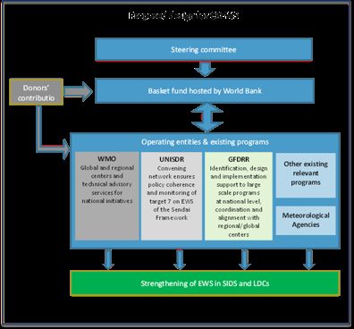
Beyond forecasting weather, advancements with new climate forecasting technologies (e.g.,
    drought forecasts with a season lead-time) have led to unprecedented opportunities to provide longer
    lead times enabling people and authorities to protect property and infrastructure. This is the
    underpinning driver for the development of the Global Framework for Climate Services (GFCS). The
    GFCS aims to supply climate services (data, forecasts and analysis), expand the globally coordinated
    network of WMO to other global producing centers, and establish a network of regional climate
    centers to enable cascading of climate technologies through provision of relevant and useful climate
    services to National Meteorological and Hydrological Services (NMHSs).

Global Frame for Climate Services (GFCS)
•     Vision
        o To enable better management of the risks of climate variability and change and adaptation to
             climate change, through the development and incorporation of science-based climate
             information and prediction into planning, policy and practice on the global, regional and
             national scale
•     Creation
        o Established during the third World Climate Conference in 2009
•   Mandate
      o Deal with past, current and future climate and its impacts on natural and human systems on
        global, regional and national scales
      o Cover immense user needs for Climate services, through unprecedented collaboration among
        institutions across political, functional and disciplinary boundaries
      o Facilitate, coordinate and try to avoid duplication, through international arrangements
        building upon the established global observations and research programs as well as
        operational structures into an end to end product generation, service provision and
        application system.
Box 1

    1.2. Lessons Learned
       Many countries have recognized the need to strengthen MHEWS by enhancing their hydro-
    meteorological warning services combined with improving their emergency plans and operations, to
    better prepare for hydro-meteorological and climate-related hazards. Those countries that have
    successfully built these systems have benefited from dramatic reduction in deaths related to weather
    extremes, as well as various additional benefits to their economies. Unfortunately, analysis shows that
    the countries that are most vulnerable to the impact of climate and weather extremes often have the
    lowest early warning capabilities, due to poorly functioning NMHS, weak or non-existent
    dissemination systems, and lack of effective emergency planning and preparedness that can be
    activated based on the impact-based alerts and warning information (Box 2). Over the past 20-30
    years, underfunding, low visibility, and in some instances military conflict, among other factors, have
    significantly compromised development and sustainability capacities in developing countries. Overall,
    observation networks have deteriorated, technology is outdated, modern equipment and forecasting
    methods are lacking, the quality of services is poor, support for research and development is
    insufficient, and workforces of trained specialists have been eroded.
       The capacities of implementing early warning systems in different countries and regions remain
    highly varied, within Least Developed Countries (LDC) and Small Island Developing States (SIDS),
    particularly susceptible to weaknesses in their ability to issue critical warnings to the national and

                                                      6                                                   !
local authorities and residents quickly, reliably and accurately. In LDCs, a preliminary review of
NMHS points to the need to significantly upgrade hazard data archiving systems and observation
networks, build capacity of government professionals, and integrate NMHS into national disaster risk
management systems. SIDS face many of the same issues, including need to improve network
equipment, information technology infrastructure, and professional staff capacity, as well as prepare
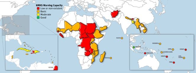
for hazards beyond tropical cyclones (see Map1).
Many investments in NMHSs have failed to make significant impacts because they focused on
providing equipment rather than considering the overall institutional reform, capacity building and
infrastructure modernization necessary to provide a better level of operational warning services. Other
projects have not taken operating and maintenance costs of new equipment, and infrastructure into
account, leading to unattractive or unworkable business models for governments and ultimately failure
of the systems due to lack of any sustainability plan. NMHSs also frequently face criticism from users
that warning information provided is not easily understood and not necessary actionable that little care
has been given to making the warning products and services targeted to user needs. The more available
and accessible NMHSs’ products are, combined with increased capacity of users to interpret the
information for decision-making, the more the NMHSs will generate benefits for society (WMO,
WBG, GFDRR & USAID 2015).
A sound risk reduction strategy for investments should include ensuring the capacity of the regional
network of WMO specialized centers to effectively produce the guidance, know-how and products that
could be channeled through these centers to support NMHSs. This support to the regional network
should include (a) access to high quality national observations, (b) access to forecast products and
analytical tools, (c) on-demand human operational guidance in case of high-impact events, (d) on-the-
job training in all aspects of the operations, and (e) institutional “twinning” that pairs more advanced
NMHSs with developing and sustaining the NMHSs in LDCs and SIDs over a long period. In many
developing and least developed countries, this type of overhaul is a major undertaking (GFDRR
publication “Weather and Climate Resilience: Effective Preparedness through NMHS” 2013).
Key Gaps and Challenges in EWS
• Risk Knowledge
o Not enough national disaster information is publicly available
o Need for quality controlled historical time-series on magnitude, location, duration, and timing
of hazards and extremes
o SIDS and LDCs do not secure enough risk knowledge resources
• Monitoring and Warning Service
o Lack of policy and legal frameworks to ascertain authority and accountability
o Overall lack of resources for sustainable operation of public meteorological, hydrological and
DRM agencies
o Not enough transboundary information sharing
o Need for continuously updated data for hazard modeling and recording of associated losses
and damage
• Dissemination and Communication
o Warning services either: does not exist; exists but people have limited access; exists and
accessible but messages not understood/trusted
o Coverage not well coordinated (local to national level and of multi-agency coordination)
o Weak feedback and verification mechanisms
• Emergency Response Capability
o Few countries consistently review, update or practice preparedness plans linked to warning
systems
o Need for specific information tailored for supporting decisions in specific contexts (e.g.
emergency planning, risk management in sensitive sectors)
o Define roles and responsibilities of EWS stakeholders
7 !EWS current status in selected SIDS and LDCs
!
based on the capacity of Hydrometeorological services to provide
warning
8
In LDCs and SIDS :
- About ¾ of countries have low or non-existent or basic capacity to provide early warning
- Only 4-5 countries have good capacity to provide early warning
- (source GFDRR based on WMO data)2. The CREWS initiative in the context of COP 21
2.1. EWS as a component of INDCs
In the context of the COP21 in Paris the mandate of which to “develop a protocol, another legal
instrument or an agreed outcome with legal force under the Convention applicable to all Parties,
which is to be completed no later than 2015 in order for it to be adopted at the twenty-first session of
the Conference of the Parties (COP) and for it to come into effect and be implemented from 2020.”
decision 1/CP.19 adopted in Warsaw, 2013, invited all Parties to initiate or intensify domestic
preparations for their Intended Nationally Determined Contributions (INDCs) towards achieving the
objective of the Convention as set out in its Article 2. In decision 1/CP.20, adopted in Lima (2014) the
COP also invited all Parties to consider communicating their undertakings in adaptation planning or
consider including an adaptation component in their intended nationally determined contributions.
By mid-September 2015, about 60 countries presented their INDC. Most of developing countries
and in Particular SIDS, LDCs and African countries presented a contribution which includes both
adaptation and mitigation. The overwhelming majority of these countries define early warning systems
as a priority for adaptation (see Map 2 below).
2.2. The Lima Paris Action Agenda and international collaborative actions
2.2.1. Presentation of the LPAA
The Lima-Paris Action Agenda capitalizes on the invitation to the incoming Presidencies of the
COP to enhance the implementation of climate action. The purpose of this paper, authored by the
COP20/CMP10 Peruvian Presidency, the incoming COP 21/CMP 11 French Presidency, the UNFCCC
Secretariat and the Executive Office of the Secretary-General of the United Nations, is to complement
the “Lima-Paris Action Agenda” declaration of December 13th, 2014
The Lima-Paris Action Agenda is a joint undertaking of the Peruvian and French COP presidencies,
the Office of the Secretary-General of the United Nations and the UNFCCC Secretariat. It aims to
strengthen climate action throughout 2015, in Paris in December and well beyond through:
• mobilizing robust global action towards low carbon and resilient societies;
• providing enhanced support to existing initiatives, such as those launched during the NY
SG Climate summit in September 2014; and
• mobilizing new partners and providing a platform for the visibility of their actions,
commitments and results in the run up to COP21.
During COP21, the four partners will respond to the Lima Call for Climate Action by convening a
series of Action Days as well as a High Level Meeting on Climate Action, i.e. the ‘Action Day’ which
will take place on December 5th.
The Action Day will be supported by a sequence of ‘Thematic Action Days’ (or LPAA focus: cities
and sub-national, energy access & efficiency, renewable energy, transport, innovation, agriculture,
forests, private finance, resilience, buildings, business, short-lived climate pollutants). They will
consist of high level official events that will highlight all the cooperative and individual commitments
per sector or themes. The ‘Thematic Action Days’ will enable the stakeholders to present issues and
existing solution pathways for each of the main action areas of the Agenda.
As a whole, these days will showcase the magnitude of mobilization and the credibility of
corresponding commitments. In this way, it will contribute positively to the implementation of the new
climate agreement beyond 2015.
The CREWS initiative will be fully integrated to the Lima Paris Action Agenda, and will be
showcased during the Resilience day and the Action Day in COP21.
9 !MAPS of EWS in the Intended Nationally Determined Contribution
(INDC)
Maps of countries with EWS identify as
an adaptation priority in their INDC
Countries with explicit reference to EWS in the adaptation part of the INDC
Countries without explicit reference to EWS in the adaptation part of the INDC
10 !2.2.2. The G7 commitments
The G7 Initiative on climate risk insurance – InsuResilience – was adopted at the G7 Summit in
Elmau/Germany in June 2015. Rapid action is required to achieve the ambitious goal of insuring up to
400 million additional people by 2020. A set of key measures for rapid action are described below and
in more detail in the document. This set of rapid action shall be prepared within the next months to be
publicly announced before or at UNFCCC COP21 in Paris.
Lead by Germany, the current G7 presidency, InsuResilience aims to mobilize donors countries and
the private sector to enhance climate risk insurance access in LDC and low income countries. As
specified in the G7 leader’s declaration, InsuResilience and CREWS will work closely to provide
meaningful means of adaptation to the most vulnerable countries.
3. CREWS Initiative concept
3.1. Rationale
Extreme weather events are among the most harmful impacts of climate change. Disaster risk
reduction (DRR) is an essential element of resilience and adaptation for communities and societies
facing climate disruption. Multiple studies and analyses clearly demonstrate that prevention, alert with
Early Warning Systems (EWS) and risk information are key elements for managing of disaster risk
and among the best options to mitigate the impacts and costs of such events. Further, the World Bank
estimates that because some of the most expensive components of EWS have already been built (e.g.,
earth observation satellites, global weather forecasting system), the needed investments are relatively
modest and would globally deliver benefits 4 to 36 times the investment costs (Hallegatte 2012).
The Sendai Framework for Disaster Risk Reduction 2015-2030 recognized the need to strengthen
Multi-Hazard Early Warning Systems (MHEWS), especially by enhancing their hydrometeorological
warning services combined with improving their emergency preparedness and response plans and
operations to better prepare for hydrometeorological and climate-related hazards. The Sendai
Framework also recognizes the need to develop, periodically update and disseminate risk information
to decision makers, the general public and communities at risk and to systematically evaluate, record,
share and publicly account for disaster losses.
Unfortunately, over the past 20-30 years, underfunding and low visibility, among other factors,
have significantly compromised the effectiveness of National Meteorological and Hydrological
Services (NMHSs) and disaster risk management in developing countries. COP21 and the Paris
Alliance offer a unique opportunity to progress in the deployment of risk information and seamless
EWS i.e. encompassing weather, water and climate-related risks and addressing them over the short,
medium and longer term with a multi-hazard approach.
The capacities of NMHSs and disaster risk management related agencies in different regions
remain highly uneven, with Least Developed Countries (LDCs) and Small Island Developing States
(SIDS) facing particular capacity shortfalls. In LDCs, a preliminary review of NMHSs points to the
need to significantly upgrade observation networks, build capacity of government professionals, and
integrate NMHSs into national disaster risk reduction plans and strategies. SIDS face many of the
same issues, including the need to improve network equipment, information technology infrastructure,
and professional staff capacity, as well as prepare for hazards beyond tropical cyclones. Links to
global and regional centers supporting national agencies also need to be strengthened.
As part of the Lima-Paris Action Agenda, the Climate Risk and Early Warning Systems (CREWS)
initiative will show that, notwithstanding its efforts to reduce greenhouse gas emissions, the
international community is committed to improving adaptation to extreme weather and hydrological
events and tackling the immediate consequences of climate change, in the LDCs and SIDS in
particular.
11 !CREWS as important building block for strengthening resilience
• Program funding will contribute to narrowing the gap between priority needs in the
developing countries and available funding.
• Implementing parties (WMO, GFCS, UNISDR, WBG/GFDRR) have complementary
strengths and breadth of analytical, technical and operational knowledge.
• Proposed integrated approach by focusing on the MHEWS will help to address key
systemic deficiencies including building long-term capacity and sustainability.
• Proposed partnership will improve donors coordination on the ground, ensure
complementarity and avoid overlap with other existing or future initiatives.
Box 3
3.2. Concept and implementation
3.2.1. Objective
The objective of the CREWS initiative is to significantly increase the capacity for seamless
MHEWS, to generate and communicate effective impact-based early warnings, and risk information
for hazardous hydro-meteorological and climate events to protect lives, livelihoods, and property in
LDC and SIDS.
3.2.2. Strategic links
The CREWS initiative is a direct contribution to the target 71 of the recently adopted Sendai
Framework for Disaster Risk Reduction 2015-2030. It will contribute to the Disaster Risk Reduction
priority area of the Global Framework for Climate Services (GFCS) and will support the International
Network on Multi-Hazard Early Systems (IN-MHEWS), a multi-stakeholder partnership proposed at
the Third United Nations World Conference on DRR (WCDRR).
3.2.3. Institutional arrangement and governance
The CREWS initiative will be operationalized through multiple partners, including the World Bank
Group/Global Facility for Disaster Reduction and Recovery (GFDRR); the World Meteorological
Organization (WMO) and the United Nations Office for Disaster Risk Reduction (UNISDR).
The Initiative foresees the establishment of a basket fund hosted by the WB to channel funding to
the existing and relevant programmes and actions supported by the trust funds of these three main
partners:
• GFCS Trust Fund to support WMO global and regional centers, to promote coordination
and alignment and to provide technical advisory services for identification, design and
implementation with national initiatives;
• UNISDR Trust Fund for ensuring policy coherence, and adherence to the United Nations
Plan of Action on DRR for Resilience and the global targets of the Sendai Framework for
Disaster Risk Reduction 2015-2030;
1Sendai Framework for Disaster Risk Reduction 2015-2030 - target 7 : “substantially increase the availability and access to multi-
hazard early warning systems and disaster risk information and assessments to the people by 2030”
12 !• GFDRR Trust fund for the identification, design and implementation support to large scale
programs at national level, as well as coordination and alignment of these programs with
regional and global centers.
The governance of the CREWS initiative will be assumed through a steering committee (priorities,
funds allocation, planning) supported by a light secretariat (coordination, reporting, monitoring and
evaluation) relying on WMO-UNISDR-GFCS-WB/GFDRR expertise. Projects will be implemented in
strong coordination with other actions related to NMHSs (e.g. the African Ministerial Conference on
Meteorology Integrated African Strategy for Meteorology (Weather and Climate Services) and the
WMO-AfDB-WB/GFDRR joint initiative strengthening Climate and Disaster Resilience in Sub-
Saharan Africa Regional Framework Program to Improve Hydromet Services). The governance
structure to be put in place will ensure synergies and complementarities and avoid duplication of
actions.
The first phase of the CREWS initiative will be implemented over a period of eight years (with five
years for project commitments and allowing three years for project completion) with an expected total
financial contribution of US$100 million from multiple donors.
"
13 !3.3. Main components and activities
The CREWS initiative will strive to leverage and enable major investments to (i) strengthen the
linkages between WMO global and regional centers for enhanced provision of technical and
operational support to NMHSs and national early warning services and risk information; (ii)
strengthen the NMHSs and their capacity to provide warnings and services and risk information2; and
(iii) improve the linkage between warning services and effective emergency management including
local and national emergency plans and the use of risk information for risk reduction.
The CREWS initiative will optimize its actions by using the outcomes of other programmes in the
areas of risk information and risk assessment, including linking hazard information to exposure and
vulnerability information and tracking associated damages and losses.
The CREWS initiative will facilitate exchanges of experience, with relevant forums and partners,
and support the development of a community of practice, namely based on the backbone provided by
WMO’s institutional infrastructures at all levels. To ensure connection with the broader DRM
community, CREWS members would meet in alternative years at the Global Platform for Disaster
Risk Reduction arranged by UNISDR and the Understanding Risk Forum arranged by WB/GFDRR.
Broad stakeholder participation, including engagement of the private sector will be ensured through
active communication and contacts set up by the partner institutions, and specific events organized on
the occasion of thematic fora or regional platforms. Representatives of stakeholders will also be part
of the steering committee.
CREWS action plan in a nutshell
"
2Information on hazards and extreme events and tailored hydrometeorological and climate information for risk
management in climate-sensitive sectors.
14 !3.4. Geographical scope
The CREWS initiative will be primarily focused on low income countries and small island
developing states, while also leveraging resources to strengthen the cascading system of WMO global
and regional centres that support them. An initial focus (2016) will be given to selected high risk
countries to be identified by the CREWS Partners to build upon ongoing efforts and provide replicable
methods and results to expand the initiative in order to cover all LDCs and SIDS with no effective
(MH)EWS by 2020.
4. Mobilization of relevant international organizations
The CREWS Initiative relies on the mobilization of the three main international organization
specialized in DRR and EWS and risk information: WB/GFDRR, UNISDR and WMO. CREWS aims
to act as a catalyzer for the already existing programs of these three institutions which rely on more
than 20 years of experience in the support of vulnerable countries to build resilience.
4.1. WMO
The World Meteorological Organization (WMO) is a specialized agency of the United Nations. It is
the United Nations system's authoritative voice on the state and behavior of the Earth's atmosphere, its
interaction with the oceans, the climate it produces, and the resulting distribution of water resources.
WMO was founded in 1873 as the International Meteorological Organization and joined the United
Nations in 1951. It has a membership of 191 Member States and Territories. As weather, climate and
the water cycle know no national boundaries, through WMO these Members achieve the international
cooperation essential for the development and application of meteorology. WMO National
Meteorological and Hydrological Services, supported by WMO Regional and Global centers, provide
operational weather, water and climate services worldwide. WMO technical commissions, regional
associations, and programmes engage hundreds of institutions and thousands of experts in a common
global agenda. This agenda includes the protection of life and property against natural disasters, as
well as safeguarding the environment and enhancing the economic and social well-being of all sectors
of society, in areas such as food security, water resources and transport. Through the efforts of these
actors, WMO promotes cooperation in the establishment of networks for making meteorological,
climatological, hydrological and geophysical observations, as well as the exchange, processing and
standardization of related data, and in technology transfer, training and research.
WMO operates a large number of programmes relevant to the CREWS initiative. These support
implementation of early warning systems for everything from flash floods, coastal inundation, riverine
floods, tropical cyclones, severe weather, drought, and seasonal climate anomalies to long range
climate changes. Additional programmes address the observing systems and data management
systems for implementing not only early warning systems but also for anticipating the duration,
location, magnitude and timing of hazard events and for recording and analyzing associated losses. In
addition to providing hands on support for implementation of these measures at country and regional
levels, WMO’s programmes and technical commissions create the guidelines, norms and standards for
the implementation of such systems globally.
4.2. World Bank/GFDRR
The World Bank has played a key role in recent years to bring attention to the economic benefits of
hydromet services and need to scale up investment in this area. Since the mid-1990s, the World
Bank's support has expanded in volume and scope. Projects have increasingly adopted a
comprehensive, NMHS systems approach – encompassing equipment, capacity building,
15 !observational infrastructure, and links with end users – in order to build institutions that are effective
and valued.
In spring 2011, GFDRR launched a Hydromet Program. The Program, implemented in close
collaboration with the World Bank and WMO is currently active in more than 40 countries. It aims to
help developing countries by: (i) providing analytical support and knowledge management concerning
weather and climate information systems and services; (ii) building capacity and providing technical
assistance to World Bank teams through workshops, training sessions, and advisory services; and (iii)
facilitating portfolio development and operations in priority countries.
The World Bank engagement in Hydromet, which received support from GFDRR technical team is
currently estimated at $400 million. To support these engagements, the World Bank through GFDRR
maintains close collaborations with WMO, as well as with a number of NHMSs in advanced
economies.
Two recently launched programs are also of relevance to this initiative. The WMO, the World
Bank and the African Development Bank (AfDB) have jointly launched in July 2015 the Africa
Regional Framework Program to Improve Hydromet Services to help address critical capacity
bottlenecks in Africa. The World Bank is also scaling up it programs in support of Small Island
Developing States (SIDS), and is working on a new initiative to strengthen resilience to natural
disaster and climate change.
The WBG/GFDRR will bring its operational experience as a grant making facility; its ability to
effectively link the grant funding with broader development support, mostly through IDA funding,
thus scaling up the development impact of donor funds and ensuring long –term sustainability.
4.3. UNISDR
UNISDR will be supporting the CREWS initiative in several ways. UNISDR will monitor the
Sendai Framework for Disaster Risk Reduction 2015-2030 including the target on multi-hazard early
warning systems. Such information will be useful identify gaps and to course correct the
implementation of CREWS in the future. UNISDR is the secretariat for the Open Ended
Intergovernmental Expert Working Prop on Indicators and Terminology related to disaster risk
reduction. The Working Group will be developing indicators and updating terminology on early
warning systems. Such work will be key to how we measure progress and have clearer ideas on
concepts related to early warning systems projects and programmes.
UNISDR hosts the biennium Global Platform for Disaster Risk Reduction and regional meetings
and platforms where updates on CREWS initiative, promotion and best practice can be shared.
UNISDR has a bank of risk knowledge and information to support CREWS with the production of the
Global Assessment Report and global risk analysis modelling. UNISDR also has a extensive network
of stakeholders (governments, private sector, science and technology, local government, communities
and practitioners, NGOs and parliamentarians) that can be brought in as partners to the CREWS as
appropriate.
Finally, UNISDR has been tracking progress on early warning systems since the Hyogo
Framework of Action in 2005. UNISDR provides advice on the strategic direction and policy on the
priorities of CREWS. In addition, UNISDR is well-connected into relevant instruments like the
SAMOA Pathways and the post-2015 development agenda (including the Sendai Framework for
Disaster Risk Reduction 2015-2030; the 2030 Agenda for Sustainable Development; and the future
outcomes of COP21, the World Humanitarian Summit, and HABITAT III). UNISDR is working
towards better coordination and mutual reinforcement and coherency among the instruments, for
example cross referencing the international agreements; developing common targets, indicators and
reporting; highlighting the needs and challenges of SIDS and LDCs and promoting co-beneficial
partnerships (like the CREWS) in support of the instruments.
16 !5. CREWS process
5.1. The first two meetings (July 6 and September 8, 2015)
France and its partners organized two technical meetings associating potential donors
countries to shape the initiative and mobilize international finance for the trust fund.
• The first meeting (July 6, 2015) allowed to discuss in depth the structure of the
initiative, the existing needs in the most vulnerable countries, and the governance
of the initiative. Support has been expressed by Norway, the European Union
Commission, and Japan.
• The second meeting (September 8, 2015) helped to clarify CREWS modus
operandi and has demonstrated its relevance and coherence. Support and
encouragement of the initiative were made by Australia, Germany, Spain, New-
Zealand and again by Japan, Norway and the European Union.
5.2. Next steps : tentative agenda
• New York UNGA, September 29, 2015: Side event organized by France and its
partners to present the CREWS initiative
• Lima, World Bank / IMF fall meeting, October 7-9, 2015: Presentation of the
CREWS initiative as part of the Cooperative actions of the climate agenda
• Paris, November 30 – December 12, 2015 : COP21
o December 2: COP21 Resilience Day
o December 5: COP21 Action Day
• January, 2016 : First meeting of the steering committee
6. Cases studies
As already mentioned, over the past 20-30 years, low visibility and underfunding, among other
factors, have significantly compromised the effectiveness of National Meteorological and
Hydrological Services (NMHSs) and disaster risk management in developing countries. The
underfunding has led to a) a deterioration of observation and communication networks, b) a lack of
modern equipment and facilities, c) poor quality of services, (d) insufficient support for research and
development, and (e) an erosion of the workforce.. The capacity and technological gap between
developed and many LDCs and SIDS is very significant and continues to grow. The improvement of
the situation will require long-term commitment of the national governments, allocation of significant
resources and effective cooperation among donors. The modernization of this sector is technically and
institutionally challenging and will be impossible for most LDCs and SIDS without sustainable donor
commitment.
The following section provides a brief illustration of the needs, challenges, opportunities and
potential priority interventions in a few LDCs and SIDS which the proposed EWS Initiative may
support. It will also illustrate and make reference to a few ongoing activities of the World Bank/
GFDRR, which could benefit from the proposed initiative to achieve better development outcomes.
The World Bank and other IFIs started investing in this sector relatively recently. However,
development of sustainable design and implementation of hydrometeorological and EWS investments
has proved to be challenging due to the relatively small size of the sector, frequent lack of visibility on
the national level, significant technical complexity and weak institutional background. Some of these
17 !challenges could be addressed with the help of targeted donor support as the proposed EWS Initiative
which can complement and improve performance of traditional World Bank investments.
6.1. Democratic Republic of Congo (DRC)
6.1.1. Background and development needs in the sector
The Democratic Republic of Congo (DRC) is one of the poorest countries in the world where
development assistance is extremely challenging. Despite its abundance in natural resources, it is
ranked second last in the latest Human Development Index. DRC is Africa's third largest country. The
Congo River is not only Africa's second longest (4,700 km) and the world's deepest river (over 220
m), but it also has the world's third largest flow (about 1300 km3/year). It is not surprising that the
continent's biggest hydropower-potential is found in DRC. For example, the Inga hydroelectric
scheme has a 40,000 MW capacity alone. The typical climate involves high rainfall (1,700 mm/year)
which often leads to flooding and landslides, while the southern part of DRC is prone to droughts. The
country has the highest frequency of thunderstorms in the world.
The WBG preliminary assessment of the sector undertaken in 2013 indicated that the status of
national meteorological, hydrological and DRM agencies is very poor. For instance, despite
significance of water resources for the country economic development there is no dedicated
Hydrological Agency in DRC and no reliable data on water resources. The National Agency of
Meteorology and Remote Sensing by Satellite (MettelSat) and Airways Agency (RVA) which are
authorized to collect weather and climate information experience severe lack of resources. The
MettelSat, for instance, has not received funding for its operations and maintenance since the early
1990s; during this period, the government budget was allocated only to support the staff costs.
MettelSat has a significant workforce (about 400 staff) but more than 75 percent of the staff is at the
retirement age or exceeding it. The qualification of the workforce needs significant improvement too.
As the result, there is an overall lack of reliable or sometimes any information on weather, climate
and hydrology in the DRC. There is no operational early warning system in the country. There are few
regular products available to the country users such as basic weather forecasts often distributed
through weather studio, seasonal forecasts, and some remote sensing data. Most of this data and
information is not reliable. MettelSat indicated, for instance, that accuracy of its weather forecasts (24
hours lead time) is below 60%, which is extremely low. The DRC produces neither hydrological
forecasts, severe weather forecasts nor other products needed to reduce the adverse impacts of weather
hazards, nor information that would improve the performance of weather dependent sectors.
There are a few international programs contributing to hydrometeorological data collection, but
clearly they could not compensate the lack of national efforts. Among donor assistance programs in
DRC are AMESD, Congo-HYCOS and SADC-HYCOS. These projects are implemented through and
supported by CICOS, WMO, GIZ, and EU. Additionally, MettelSat is interacting with such regional
organizations and centers as the Meteorological Association of South Africa (MASA), ACMAD and
IGAD. Taking into account urgent national needs and the DRC global “footprint” there is a clear need
for additional and significant donor support in this sector.
6.1.2. Potential scope of intervention
The scope of the potential intervention should be sufficient to make a difference and have some
visible positive impact. After 30-40 years of neglect, the hydrometeorological /EWS sector needs
considerable resources and efforts to rebuild its institutional framework, create the most basic
infrastructure and develop a service delivery culture and capacity in the sector, which is now very
weak. At the same time the proposed activities should be affordable to the government in order to be
sustainable. Finding the appropriate balance between significant and competing development needs,
and limited government resources and capacity will be one of key challenges. But this also provides
additional justification for donor support taking into account significant element of global public
goods, which can be generated.
18 !In view of these considerations, the scope of interventions which can be funded by the proposed
EWS initiative can include the following main activities: (a) assessment of national capacity and
capabilities to improve delivery of early warnings, weather, climate and hydrological services; (b)
support for high priority technical assistance activities and small scale investments; (iii) strengthen the
linkages between global and regional WMO centers for enhanced provision of technical and
operational support to improve national hydrometeorological and early warning services and risk
information.
The first group of activities may include the following tasks:
• A review of the natural hazards and environmental conditions and their impact on
population and economy of DRC.
• An assessment of the current status and requirements for EWS, weather, climate and
hydrological information and services.
• An assessment of the institutional capacity of relevant DRC agencies including their
mandates, legal basis and regulations, staffing, funding, development plans and priorities;
the status of infrastructure; products and services; and international activities.
• A review of donors operations (including IFI projects) relevant to improve products and
services;
• A social and economic assessment of the potential benefits of modernized early warning
and hydrometeorological systems and enhanced service delivery;
• A plan for a modernization program or road map to improve EWS and
hydrometeorological products and services to meet current and future requirements of
DRC.
The second group of activities of activities may include the following tasks:
• Basic and specialized training of NMHSs and DRM staff, study tours, joint workshops
with users including raising awareness and evacuation drills at the community level;
• Hiring technical experts to address priority issues such as development of technical
specifications and bidding documents, development of recommendations for improvement
of forecasting and early warnings including development of warning protocols;
• Development of National Framework of Climate Services, support for climate outlooks
and projections;
• Supporting small-scale priority investments such as improvement of communication
network, procurement of computers, specialized forecasting software, vehicles and
priority consumables for essential operations such as upper air sounding.
The third group of activities of activities may include the following tasks:
• Strengthening the linkages between MettelSat, RVA and other relevant DRC agencies with
global and regional WMO centers. This may include introduction and operationalizing of
the WMO Severe Weather Forecast Demonstration Project, Flash Flood Guidance and
similar WMO flagship initiatives to DRC.
• Enhanced provision of technical and operational support to improve national
hydrometeorological and early warning services and risk information could include
ongoing support from one or several global forecasting centers such as Meteo France,
ECMWF, UK Met Office or US NOAA/NWS.
• In case there will be significant investment projects funded by IFI or another donor, this
activity may support g services and risk information could include ongoing support from
one or several global forecasting centers such as MettelSat, RVA, etc.) which would assist
in implementation of the investment project.
19 !The cost estimate for such investment should be evaluated based on a more thorough assessment, it
is clear that it will be significant (above USD 10 million) and should therefore be implemented jointly
with an IFI such as WBG or African Development Bank. In any event, the proposed project will be in
a high risk - high reward category. Risks are attached to a challenging set of institutional,
infrastructure and capacity gaps but potential success in DRC can generate significant national and
regional/global benefits. In brief, the expected results of such a project in DRC could include:
• Timely and reliable forecasts at the national and local levels leading to a reduction of the
impacts of disasters on people and property;
• Improved delivery of weather, climate, hydrological services and multi-hazard warnings
to citizens and weather-dependent sectors; and,
• Improved international and cross-border collaboration, including on drought, severe
weather and flood warnings.
6.2. Sahel: Mali and Burkina Faso
6.2.1. Background
Sahel has faced repeated droughts with the most severe ones occurring during the 1960s and the
1980s. Between 2010 and 2012, two large-scale droughts impacted up to 19 million people; hence,
resilience in the Sahel over the last decades has been focusing nearly exclusively on food security,
with locusts and droughts as key natural hazards. However rapid-onset hazards such as flooding, flash
flooding, storms and wildfires have also becoming a threat to lives and livelihoods in the Sahel.
Recorded economic losses linked to extreme hydro-meteorological events indeed have increased
nearly 50 times over the past five decades. Early warning systems (EWS) are a critical life-saving and
livelihood-saving tool for hydrometeorological hazards in the region.
The table below shows the status of 5 of the Sahelian countries, which indicate a sizable population
is at risk from natural hazards across 5 countries, while their capacity to manage disaster risk is rather
limited. Of these, the Global Facility for Disaster Reduction and Recovery (GFDRR) has provided
technical assistance to Burkina Faso and Mali to identify their DRM priorities, including early
warning systems. This case study is focused on these two countries.
GNI per Population Agriculture F o o d Population Fragile
Country Income level capita (growth) in GDP insecurity at risk DRM Capacity States
current M people Composite
USD Million (%) affected in % (rank in score (0 worst; FY 14
2012 2012 2012 2011 2013 (%) SSA) 5 best)2 WB
Burkina
Faso Low 670 16.5 (2.9 %) 34% 2.1 (27%) 61.7% (7) 3.2 No
Chad Low 740 12.4 (3.0 %) 14% (2008) 3.6 (29%) 20.5% (24) 1.7 Yes
Mali Low 660 14.9 (3.0%) 39% (2009) 4.2 (28%) 29.6% (20) 2.8 Yes
Mauritania Lower Middle 1,110 3.8 (2.5%) 16% 0.7 (18%) No data 2.2 No
Niger Low 370 17.2 (3.8%) 40% (2013) 6.4 (37%) 76.4% (3) 2.2 No
6.2.2. Baseline
Burkina Faso: The Directorate General for Water Resources (DGRE) is responsible for surface
and groundwater monitoring. However, out of 95 hydrometric monitoring stations, most discharge
data is collected monthly where data transmission, validation and processing is done manually. The
Directorate General for Meteorology (DGM) is responsible for weather and climate services, notably
agro-climatology. DGM operates a network of 14 manual agro-meteorological stations and two
20 !Doppler radars of which only one is operational. Currently, the DGM only serves weather
modification needs as it is unable to provide mandated forecasting related to extreme, fast-onset
weather events because of low capacity. The National Council for Emergency and Rehabilitation
(CONASUR) is the national platform for DRM responsible for distribution of relief material, while
Directorate General for Civil Protection (DGPC) is responsible for emergency response in the urban
areas and for managing the national fire brigades.
Mali: The National Directorate of Water (DNH) is responsible for monitoring surface and ground
water, including hydrological stations along Niger and Senegal Rivers. The network of hydrological
and meteorological stations is deteriorated with just 100 surface and ground water stations operational,
down from 231 stations in the 1980s. All stations are operated manually while discharge
measurements are done infrequently. The former National Directorate for Meteorology (Meteo-Mali)
was transferred into an autonomous agency responsible for meteorology two years ago however, all 16
synoptic stations of the meteorological monitoring network are still operated by ASECNA, while
Meteo-Mali only focuses on the agro-meteorological monitoring and provision of agro-meteorological
services. Meteo-Mali does not conduct a 24/7 operation for severe weather warnings and is equipped
with three conventional weather radars out of which two are operational.
In both Burkina Faso and Mali, early warning systems exist for locust, drought, availability and
price of food, all in relation with early monitoring of food insecurity. A comprehensive system for
early warning and risk assessments, in particular related to rapid-onset hazards such as flood, storms
and flash floods, is not yet available.
Regional: The national meteorological services of Burkina Faso and Mali are supported by
AGRHYMET (mainly for agro-meteorological services) and ACMAD (mainly for climate services).
Therefore, improved regional cooperation in early warning services within the Sahel, in close
collaboration with regional centers such as ACMAD, AGRHYMET and WMO Regional Specialized
Meteorological Center, is important for the development of effective risk assessment, and multi-hazard
early warning. Successful operation of hydrometeorological services and early warning systems is
traditionally based on international cooperation, combining local observation with global and regional
scale numerical weather prediction models and satellite data. Sharing of common methodologies and
good practices within the Sahel would also enable the countries to better cope with cross-border
hazards.
6.2.3. Ongoing activities
There are a number of investments/projects currently going on aiming at strengthening early
warning capacity in the region. Below are some of the representative on-going activities but the list is
by no means exhaustive.
Burkina Faso Mainstreaming Disaster World Bank $ 1.26 M (i) Strengthening CONASUR as an efficient
Reduction coordinating center for DRM in Burkina, (ii) Devising
an early warning system, (iii) Capacity building for
response institutions, and (iv) Development of micro-
projects
Strengthening climate UNDP $ 6.9 M Build and strengthen the observing and forecasting
information and early warning system. Improve communication and types/formats of
systems (EWS) for climate available information
resilient development and
adaptation to climate change, and
strengthening Adaptation
Capacities and Reducing the
Vulnerability to Climate Change
in Burkina Faso
21 !You can also read