CWATER - JANUARY 2021 PHASE 2 STUDY FINDINGS - Woods Hole ...
←
→
Page content transcription
If your browser does not render page correctly, please read the page content below
CWATER
    Complex for Waterfront Access to Exploration & Research

JANUARY 2021
PHASE 2
STUDY FINDINGS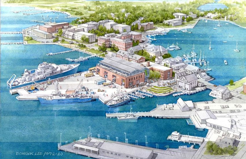
Complex for Waterfront Access To Exploration and Research (CWATER)
Phase 2 Study Findings
January 2021
R. Munier, LA McGee
Executive Summary
The Complex for Waterfront Access To Exploration and Research (CWATER) is imagined as a next‐
generation, world‐class, sustainable marine research facility that will enable fundamental advances in
ocean science, engineering and education through the 21st Century for the entire oceanographic
community. Building on the findings from the Phase 1 study completed in 2018, Phase 2 of the CWATER
Feasibility Study focused on refining the emerging design parameters with additional research,
outreach, and input from stakeholders and subject matter experts. The goals for Phase 2 center on
establishing a design approach for the primary elements of the CWATER project. The scope included:
Detailed site investigations
Sea level rise analysis and community engagement
Development of sustainable and adaptable elements
Advanced dock alternatives assessment
Conceptual building design
Permitting consultation and submission of preliminary permit applications
The results of Phase 2 have advanced CWATER design elements and critical decisions prior to launching
a detailed design phase. Phase 2 of the CWATER Design Study has yielded exceptional results. Clarity
around the design approach for sea level rise has created a baseline for cooperative planning among
research institutions of Woods Hole and initiated broader town‐wide conversations regarding the
impacts of climate change and the importance of early planning and implementation for long‐term
adaptability. The sea level rise symposia attended by well over 170 individuals has generated
considerable conversation within the local community.
These outcomes have allowed the Conceptual Design phase of work for the New Waterfront Building to
come into focus from both a programming, configuration, phasing, and initial design standpoint.
Further, detailed assessment of several innovative design approaches for the dock platform, small boat
access, and the robotic vehicle port have resulted in an innovative approach founded on a proven
structural platform of fixed piles incorporating an innovative hydraulic deck option providing for future
sea‐level rise adaptability. This work coupled with the submission of the ENF to MEPA have jump‐started
the next phase of design work for CWATER and generated substantial energy and excitement within the
WHOI community. Funding has been secured to launch the next phase of design and maintain the
project’s momentum. WHOI is positioned to remain on track with the proposed project schedule with a
target of completing shovel ready documentation by 2022.
i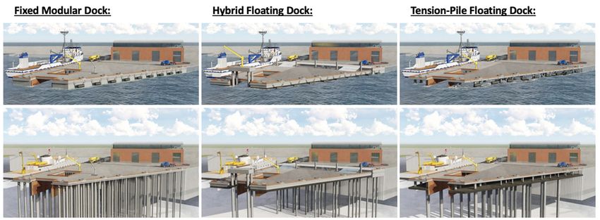
Each design element was carefully reviewed and evaluated to ensure that the preferred direction meets
the program goals and objectives. The Dock design focuses on developing a solution that is capable of
accommodating the wide range of programmatic uses now and into the future, while also
accommodating projected impacts of Climate Change and Sea Level Rise. These parameters established
the design criteria for evaluating the dock alternatives. The building needs to also adapt to the impacts
of sea level rise, while also serving as a central piece of infrastructure in support of the Institution’s
mission and programs. Furthermore, the building also needs to respond to the existing conditions on the
waterfront. Future uses, such as an increased need for robotic vehicle access and expanded test well
capabilities informed the basis of design for the Main Dock through this Phase of work.

Advancing the Sea Level Rise work from Phase 1, Phase 2 engaged Woods Hole Group, Moffatt & Nichol,
as well as a panel of WHOI experts in Climate to evaluate the current findings by the Intergovernmental
Panel on Climate Change (IPCC) and extrapolate recommendations and findings to develop a sensible
approach to accommodate operations, while also incorporating resilient approaches. These efforts
incorporated a climate change vulnerability assessment for the three primary research organizations in
Woods Hole: WHOI, Marine Biological Laboratory (MBL) and NOAA Northeast Fisheries Science Center
(NEFSC). This effort assisted in identifying critical time‐horizons, elevations, and at‐risk assets assisting
each organization in understanding a baseline risk and providing insight on adaptable solutions that can
begin to be incorporated in current‐day planning and design efforts.

Phase 2 represents a significant step forward in both depth of review and content development for the
CWATER project. The assessment of Sea Level Rise has affirmed an adaptable approach which builds for
an optimized mid‐term target of +2.5’ allowing WHOI to continue to support operations and waterfront
functions, while looking forward to an adaptable future‐state deck elevation of +4.0’ from existing. The
dock structure design has also matured with the emerging direction focused on incorporating innovative
design elements explored in detail during Phase 2 with a proven structural system developed in Phase 1.
This approach has been selected to reduce overall project risk while still providing an innovative
approach to sea level rise adaptability. These fundamental developments have propagated an
innovative design approach for the NWB including a stacked building core capable of adapting over
time. Additionally, refinement of the NWB program has engendered a compelling facility design which is
at once pragmatic and innovative. Strengthening connections to the surrounding architecture and
standing out as a beacon of sustainable and climate change ready design. Together, these findings
represent the basis for submission of the Environmental Notification Form (ENF) through the
Massachusetts Environmental Policy Act (MEPA) Office marking the beginning of the permitting process.

                                                                                                            ii
Table of Contents

Executive Summary ____________________________________________________________ i
1.0 Introduction ______________________________________________________________ 4
2.0 Sea Level Rise Analysis ______________________________________________________ 4
 2.1 Moffatt & Nichol Monte Carlo Probabilistic Modeling Analysis ___________________________ 5
 2.2 Woods Hole Group Modeling Updates _______________________________________________ 6
 2.3 WHOI Scientific Review of Moffatt & Nichol and Woods Hole Group Findings _______________ 8
 2.4 Conclusions/Recommended Approach ______________________________________________ 9
 2.5 WHOI / MBL / NOAA Collaborative Work on Village Climate Resiliency ____________________ 9
 2.6 Rising Tides Symposia ___________________________________________________________ 10
3.0 Dock Design Direction and Alternatives Assessment _____________________________ 10
 3.1 Fixed Pile Supported Dock Alternatives _____________________________________________ 11
 3.2 Floating Dock Alternatives _______________________________________________________ 12
 3.3 Robotic Vessel Port _____________________________________________________________ 15
   3.4 Small Boat Slips ________________________________________________________________ 15
4.0 Building Conceptual Design _________________________________________________ 17
  4.1 Building Program Overview_______________________________________________________ 18
  4.2 Preliminary Project Phasing ______________________________________________________ 19
  4.3 Emerging Design Approach _______________________________________________________ 20
  5.0 Project Schedule Overview _________________________________________________23
6.0 Permitting _______________________________________________________________ 24
7.0 Outreach and Engagement _________________________________________________ 24
  7.1 Internal Engagement ____________________________________________________________ 24
  7.2 External Engagement ____________________________________________________________ 25

 8.0 Outcomes and Next Steps __________________________________________________ 25
Appendices _________________________________________________________________ 27

                                                                                                  3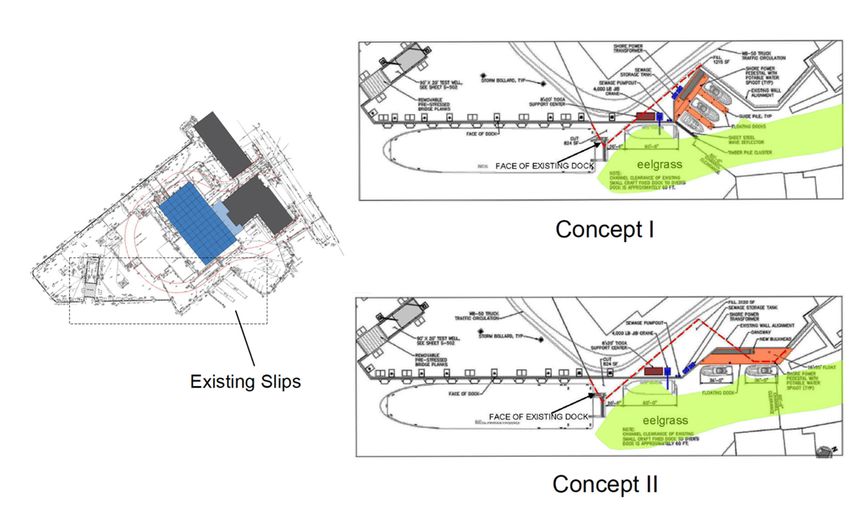
1.0 Introduction
Constructed in 1969 with funding from the National Science Foundation (NSF), the existing complex is
reaching the end of its 50‐year design life, and at 51 years old maintenance costs are increasing rapidly
with decreasing functionality. In a 2018 feasibility study supported by a grant from the Commonwealth
of Massachusetts Seaport Economic Council (SEC), WHOI determined that redevelopment is feasible and
essential to meeting the needs of the institution and the greater oceanographic community for the
remainder of this century. A second state grant, awarded in 2019, has enabled the advancement of
planning efforts from the initial study, including resiliency, preliminary designs, site characterization and
permitting. Based on these studies, WHOI has refined the vision for a new waterfront research complex
that will provide critical, upgraded infrastructure that will advance our nation’s oceanographic research
capabilities. CWATER has strong scientific merit, helps fulfill significant community research priorities,
and provides a platform for training the next generation of oceanographers. Additionally, CWATER will
incorporate sea‐level rise and coastal resiliency measures and will be designed to serve as an exemplar
for other marine centers and facilities. This will have an important, far‐reaching impact with WHOI to
provide leadership in the critical area of waterfront infrastructure adaptability and sustainability.

2.0 Sea Level Rise Analysis
A key outcome of the first SEC feasibility study was recognition of the importance of sea level rise and
resilience to all aspects of the CWATER project. WHOI has embraced the concept that the new complex
should be built in an adaptable and forward‐looking fashion. This objective has formed the underpinning
for the alternatives in development. Additionally, engagement with subject matter experts within the
Woods Hole Oceanographic Institution coupled with modeling completed by external consultants from
Moffatt & Nichol and the Woods Hole Group has provided a clearer understanding of the risks
associated with sea‐level rise and climate change in Woods Hole as well as reinforcing uncertainty
associated with long‐range projections. Based on this wide‐ranging impact and the long‐range time
horizon being considered, WHOI partnered with the Marine Biological Laboratory (MBL) and NOAA
Northeast Fisheries Science Center (NEFSC) to advance a concerted approach to sea level rise planning.
With a joint land holding of approximately 25 acres in the low‐lying portions of Woods Hole, this effort
was focused on identifying long‐range risks and exploring near‐ and mid‐term mitigation strategies for
the impacts of sea level rise and coastal storm events.

The science of climate change and translation of climate risks into design criteria are new and evolving
practices, involving uncertainty and variability. Central to this variability and uncertainty of future
greenhouse gas emissions pathways as well as the resolution of downscaling of global climate
projections for local applications. This study has leveraged projections established by the
Commonwealth of Massachusetts relative to temperature, precipitation, and sea level rise based on a
range of medium to high greenhouse gas emissions scenarios (RCP4.5 and RCP8.5).

The projections utilized in the sea level rise analysis are aligned with the state standards for the
Commonwealth of Massachusetts and utilize a probabilistic approach to local sea level rise and storm
surge projections. The Commonwealth has developed probabilistic local SLR projections downscaled
from global models and adjusted for local landform subsidence. The science of climate change is an

                                                                                                           4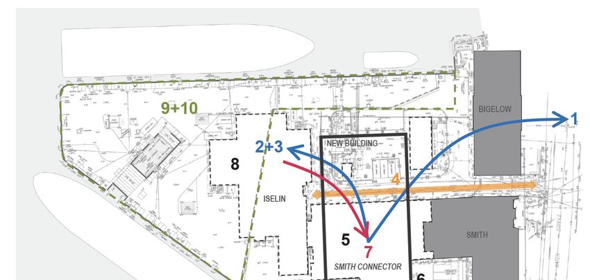
evolving field that is constantly being updated. As such, projections used for this study provide
guidelines for investment decisions based on the best understanding and knowledge available to date.
Flood level predictions made in this report are based on recent developments in the science of climate
change but are not guaranteed predictions of future events. It is recommended that these results be
updated over time as science, data and modeling techniques advance. Further, the assessment includes
certain assumptions based on reasonable engineering judgment as to the ability of buildings and
facilities to resist the projected hydrostatic forces due to flooding. These assumptions will require
additional verification and customization as individual projects move through a design phase.

2.1 Moffatt & Nichol Monte Carlo Probabilistic Modeling Analysis
As mentioned above, Moffatt & Nichol developed a sea level rise (SLR) analysis utilizing a probabilistic
modeling approach leveraging a Monte Carlo analysis. These SLR projections for this project were based
on the Kopp et al. (2017) study (using the K14 projections, that follow the methodology of the Kopp et
al. (2014) study), which provides probabilistic projections for SLR at the Woods Hole, MA tide gauge that
include the local effects of relative vertical land motion (e.g., subsidence). The K14 projections for global
mean sea level change is comparable to the most recent projections from the Intergovernmental Panel
on Climate Change (IPCC), as presented in the Special Report on the Ocean and Cryosphere in a
Changing Climate (SROCC) (Portner, et al. 2019). Both the nuisance flooding and storm surge flooding
analyses considered the K14 SLR projections for Representative Concentration Pathway (RCP) scenarios
4.5 and 8.5 (intermediate and high emissions, respectively).

Storm flooding analysis for this model was based on the United States Army Corps of Engineers (USACE)
North Atlantic Coast Comprehensive Study (NACCS), which provides storm water level statistics for the
Woods Hole area. The NACCS storm surge probabilities were combined with the K14 SLR projections (for
both RCP 4.5 and 8.5) using a Monte Carlo Simulation (MCS) technique, which was used to combine the
storm surge and SLR projections and obtain estimates of likely flood frequencies in the future. Based on
the storm flooding analysis, several potential risk management scenarios were developed and presented
for consideration in a summary probability comparison matrix (Figure 1). This matrix provides a
comparative format indicating the annual likelihood of flooding from the current state (2020 – 6.5’) of
3.0% forward through time to understand comparative target elevations for future time horizons. Based
on these results, M&N recommends the following:
    ●   To design the dock based on the expected level of the 5% annual chance flood in 2070 (7.4ft to
        7.7ft, for RCP 4.5 and 8.5, respectively). With a 1ft freeboard allowance (e.g., to reduce wave
        over‐wash) the corresponding deck elevation should be 8.5ft NAVD88.
    ●   With a view to the possible project life beyond 2070, an alternate approach would be to build
        the dock to a higher elevation of 10.5ft, which would keep the annual chance of flooding below
        5% through year 2100 (best estimate).
    ●   A third approach would be to combine these first two approaches and build the dock initially to
        elevation 8.5ft, but with provision for raising the structure to 10.5ft if/as needed later in the
        project life.

                                                                                                            5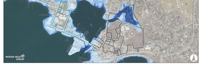
Figure 1: Annual Likelihood of Flooding - Monte Carlo Analysis Summary Matrix

2.2 Woods Hole Group Modeling Updates
During Phase 2, Woods Hole Group (WHG) revisited their Phase 1 sea level rise assessment. These
figures were re‐run based on the most recent modeling of coastal and landform impacts through
shoreline change, probabilistic modeling, as well as coastal inundation modeling based on the
Massachusetts Coast Flood Risk Model (MC‐FRM). Additionally, WHG also incorporated the latest
modeling from the 2019 IPCC report and updates to the RPC values. All of these updates coupled with
available historic sea level rise data from the WHOI NOAA tide gauge data were synthesized to provide a
detailed view of coastal flood exceedance probability (CFEP) and depth of flooding maps for Woods
Hole.

The CFEP and depth of flooding assessment reinforced the findings from 2018 with a target increase of
+2.5’ in deck elevation by 2050 to avoid most nuisance flooding and reduce impacts of storm flooding.
By 2070 increasing the deck height by an additional +1.5’ is recommended to reduce the impact of
nuisance and storm flooding. A graphic of future mean higher high water (MHHW) for Woods Hole is
illustrated in Figure 2. As illustrated in the graphic by 2100 MHHW is projected at 8.69’ NAVD 88 with
the current deck elevation at approximately 6.5’ NAVD88 the projection for +2.5’ and +4’ from current
deck elevation begin to have more context.

                                                                                                         6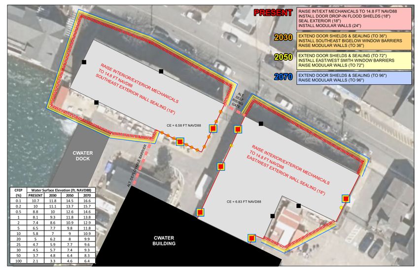
Figure 2 - Future mean higher high water (MHHW) in Woods Hole

In addition to establishing the datum for the CWATER initiative, assessment of existing village assets
including Smith and Bigelow was conducted. Building on the resilient design of CWATER, a district‐level
adaptation plan for these facilities has been developed and is represented in Figure 3.

                                            Figure 3 - District-level adaptation plan; WHOI Iselin Marine Facility

                                                                                                                7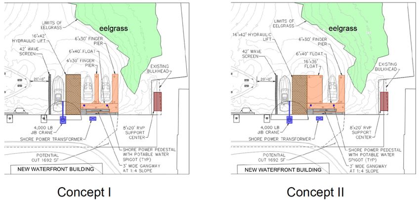
The concept for this district strategy is to protect critical infrastructure from storm surge (to the 1% CFEP
water surface elevation projected over time) in an incremental and modular way, starting with present
needs and adjusting over time. The design is intended to be integrated with CWATER. Under present
conditions, there is a need to address storm surge from the Harbor, which is achieved by a combination
of building dry‐floodproofing (façade sealing and door barriers) and modular walls (creating courtyards
around most of Bigelow, the Water Street side of Smith, and the southeast corner of Smith). These
recommendations sought to minimize individual window and door flood shield treatments while
preserving the access way between the buildings for Iselin Dock traffic. There is also an alternative
proposed for a deployable barrier between Bigelow and CWATER, and a rising gate at Water Street to
further reduce building treatments. Over time, the modular walls and any building treatments (façade
sealant, window and door flood shields) would need to be adjusted for additional flood protection
(phasing is color keyed on Figure 3). These elements would be designed for modularity to accept
additional protection over time, as needed.

The goal of this adaptation plan is to maintain existing uses and align with CWATER project while
offering incremental flood protection for these existing facilities. Over the long term (potentially 2100)
there may need to be a consideration for tidal inundation, which would also by necessity require
coordination with the Town of Falmouth on Water Street.

2.3 WHOI Scientific Review of Moffatt & Nichol and Woods Hole Group Findings
WHOI conducted an internal expert panel review of the approach taken by both Woods Hole Group
and Moffat & Nichol to review the CWATER flood risk and dock elevation. A key outcome of the first SEC
feasibility study was recognition of the importance of sea level rise and resilience to all aspects of the
project. WHOI has embraced the concept that the new CWATER project should be built in an adaptable
and forward‐looking fashion. This construct has formed the underpinning for CWATER alternatives in
development, as well as strategies for construction of the new facility. Furthermore, engagement with
subject matter experts within the Woods Hole Oceanographic Institution coupled with modeling
completed by external engineers have provided a clearer understanding of the risks associated with sea‐
level rise and climate change as well as reinforcing the uncertainty associated with long‐range
projections. The WHOI internal review found that the SLR projections presented by M&N and WHG are
reasonable given our current knowledge and estimates of uncertainty. The proposed increase in deck
height of 2.5 feet is recognized as a sensible first step.

Given the large uncertainties in SLR projections adapting as flexible of an approach as is feasible makes
sense. Planning for the possibility of adding additional deck elevation in the future provides some of this
flexibility, however we point out that the benefit of adding 1.5 feet later in the century may only add
approximately 15 years to the dock’s service life. They also found that there will be a contribution to
nuisance flooding from hurricanes that is not captured in the M&N analysis. For every hurricane landfall
there will likely be many more near misses. If hurricane activity is trending up, we will likely see many
more moderate inundation events as well (~3‐5 feet range). That said, these may still be infrequent
enough (and short lived) that we can accommodate them relatively easily in our operational scheme. In
many cases as a precaution we will have likely prepared for the worst and cleared the dock when a
hurricane is threatening. And these intermediate events will likely not devastate the waterfront to
impede our operations significantly. These scenarios were evaluated by Moffatt & Nichol as a part of the
feasibility studies associated with each alternative.

                                                                                                             8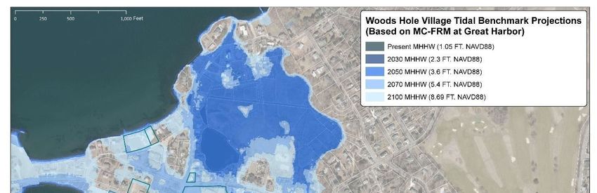
2.4 Conclusions/Recommended Approach
Based on the assessment and input from both internal scientists and external consultants, targeted
adaptability for the near‐term (through 2050) for the waterfront infrastructure suggests an overall
increase of approximately +2.5’ from the current deck elevation. This increase will provide operational
stability in the near‐ to mid‐term while also ensuring that operations can continue without substantial
impacts prior to the full realization of sea level rise.

Longer‐term planning (beyond 2070) for the waterfront suggests providing an additional +1.5’ from the
near‐term investment to allow for adaptability into the future. This benchmark suggests targeting
capacity for an overall increase of +4.0’ from the current deck elevation over the lifespan of the CWATER
complex. Achieving this objective will require a mixture of near‐term modular design strategies with
forward‐looking initial layout and infrastructure investments for the building and infrastructure.

After peer review of the study and input from subject matter experts from WHOI, the project team
determined that an elevation of 9.0 ft NAVD88 (2.5ft above the present‐day dock level) would be the
most appropriate elevation for any fixed level dock structures. Note that the structural design of any
fixed‐level dock would allow for floods in excess of +9.0ft NAVD88 without incurring damage. The
elevation is set to reduce the possibility of service interruptions.

2.5 WHOI / MBL / NOAA Collaborative Work on Village Climate Resiliency
WHOI, MBL, and NOAA NEFSC worked with Woods Hole Group (WHG) to conduct the Woods Hole
Climate Change Vulnerability Assessment (CCVA) and Adaptation Plan. WHG applied the sea level rise
and storm surge projections from its probabilistic hydrodynamic Massachusetts Coast Flood Risk Model
(MC FRM) to evaluate vulnerable assets of each organization using a risk‐based framework and
evaluation process, similar to its efforts in conjunction with the Town of Falmouth. These models were
used to assess impacts from 2030 through 2100 in order to better understand the implications on
vulnerable assets for each organization, as well as providing better context for the broader implications
of sea level rise on Woods Hole.

The scope of work of the Woods Hole Coastal Climate Vulnerability Assessment was geared towards
identifying risk levels and developing targeted strategies aimed at reducing risks from flooding,
increased storm intensity, sea level rise and storm surge at the Woods Hole facilities. In addition to
evaluating the specific facilities owned by WHOI, MBL, and NOAA NEFSC, Woods Hole Group evaluated
the community as a whole (in relationship to the ongoing functionality of these research
organizations). Ultimately, the goal of the project was to provide the three research organizations
operating in Woods Hole (as well as the greater Woods Hole community) data on likely scenarios and
degrees of potential impact in vulnerable areas, and to assist in the development and prioritization of
strategies to minimize risks to infrastructure, facilities and the community. Woods Hole Group is also
currently working with the Town of Falmouth on a Climate Change Vulnerability Assessment (CCVA) for
municipal infrastructure and natural resources and preparing adaptation strategies for a number of
vulnerable assets and areas. The Woods Hole CCVA study parameters and recommendations are
aligned and NEFSC can work in concert with the Woods Hole community and the Town of Falmouth on
joint adaptation initiatives, acknowledging that many of the assets controlled by the research
organizations cannot be adapted without collaboration and coordination with the Town.

                                                                                                            9
Based on sea level rise projections for Woods Hole and habitat modeling, projections suggest that up to
50 acres of upland area may be lost in Woods Hole to wetland migration by the end of the century while
large expanses of existing wetlands will transition to open water north of Eel Pond. Over the same time
period, 66% of the institutional assets identified in the CCVA could experience nuisance flooding, which
would interfere with normal use of research facilities. MC‐FRM projections indicate that the coastal
storm surge from a 1% event in 2050 could potentially impact 80% of WHOI’s evaluated assets, 87% of
MBL’s evaluated assets, and 93% of NOAA’s evaluated assets.
The results of the vulnerability and risk assessment provide a roadmap for WHOI, MBL and NOAA to
strategically prioritize and implement adaptation over time, incorporating coastal resilience into long‐
term planning, and more immediately incorporating long‐range thinking into near‐term investments.
2.6 Rising Tides Symposia
The Rising Tides symposium held on September 24, 2020 was the culmination of the work WHOI
conducted under the Seaport Economic Council grant to WHOI to explore Phase 2 options for WHOI’s
waterfront future. Like many coastal communities, Woods Hole, located on Cape Cod, faces an
uncertain future. Rising sea level and the potential for increased frequency and intensity of storms
present significant long‐term threats. Woods Hole is home to world‐leading marine science institutions
performing critical research from shore‐based facilities that enable access to the sea and yet, ironically,
are vulnerable to the same climate change impacts that are the subject of study. WHOI, MBL, NOAA
NEFSC, WHG joined with federal, state, local public policy makers and the Business Association to
share the work completed. The Symposium successfully demonstrated the future‐forward and
innovative work being conducted to apply climate science data and relevant policy to ensuring a
healthy and prosperous 21st century Woods Hole.
Specifically, the following goals were met at the Symposium:
1. Explore the future of Woods Hole Village as an epicenter of marine science and technology
by discussing supportive climate resiliency policy programs.
2. Share with stakeholders the state of knowledge on local climate science and opportunities
and threats to the future of Woods Hole Village.
3. Present local institutional approaches and considerations to a recent in‐depth study of
vulnerability and risk assessment geared towards identifying risk levels and developing
targeted strategies aimed at reducing climate change‐related risks in Woods Hole.
3.0 Dock Design Direction and Alternatives Assessment
The existing Iselin Marine Facility is composed of multiple structures, namely a pile‐supported platform
and an earth‐retaining bulkhead. Lesser ancillary structures include floating docks for non‐vessel access
and small crafts, lifting platforms and dock cranes. Through the second phase of the Seaport Economic
Council grant alternatives for each of these primary and ancillary elements were further refined and
reviewed to develop a narrowed set of preferred alternatives.
10As mentioned above a number of alternatives were considered during the phase 2 design process. These
expanded from the baseline assumptions of Phase 1 which resulted in a direction of a fixed pile
supported structure. A series of floating alternatives were evaluated during Phase 2 as well one with a
fully floating barge tied back to a traditional pier structure and a tension pile structure relying on a
number of submerged pontoons to create buoyancy for the entire dock structure. Figures 4 and 5
illustrate the four primary alternatives considered during Phase 2.
Figure 4 - Dock Design Alternatives Overview
Figure 5 - Section and Force Diagrams (Note: Option 1 and 1A utilize the same fixed pier design)
3.1 Fixed Pile Supported Dock Alternatives
The fixed pile‐supported dock alternative is most similar in structure to the existing dock,
which maintains a constant deck elevation regardless of the rise and fall of the tides. The primary
disadvantage of the traditional fixed pile‐supported dock alternative is that it is less adaptable to sea
level rise as compared to either of the floating dock alternatives. However, there are provisions in the
design that would allow for raising the deck elevation in the future by essentially building on top
of the structure (Option 1). With this approach the dock structure will remain at a fixed elevation
relative to sea level rise and result in increased impact from the splash zone, and likely eventual
submersion of the dock structure and portions of the deck. These impacts would likely yield increases in
long‐term maintenance as well as requiring specialty contractors and divers to perform future repairs to
the structure.
11An alternative, Option 1A, emerged through the design process as an alternative incorporating a
modular deck structure coupled with the fixed pile platform. This alternative would rely on a series of
sleeved piles which – through the use of hydraulic jacks – would allow the entire deck structure to be
raised in the future. This alternative, while more technically involved, presents an opportunity to rely on
the fixed piles and have a deck platform which can be fully elevated in the future resolving the primary
issue for Option 1 relative to long‐term operational costs.
The fixed pile‐supported dock design has provided a solid platform for the Iselin Marine Facility for over
fifty years and is therefore a time‐tested design. Also, since its construction in 1969, many important
advancements have been made in the use of materials to improve the service life of these types of in‐
water structures. For example, marine specific concrete mixes, the use of epoxy coated steel reinforcing
and cathodic protection are industry standard improvements compared to designs 50 years ago. This
should yield improved durability and reduced maintenance costs over a 50‐ to 75‐year timeframe of the
structure.
There is good reason as to why the Iselin Marine Support Facility is built the way it is. Most
importantly, the fixed structure is advantageous from an operations standpoint. Whereas access
from the bulkhead to a floating or hybrid floating structure would require truck‐rated articulating
ramps, the fixed pile‐supported design provides a constant deck elevation and solid structural
underpinning that is optimal for the transporting of heavy loads on and off vessels. Figure 6 provides a
section view of the fixed pile‐supported alternatives.
Figure 6 - Section View of the Fixed Dock Alternative
3.2 Floating Dock Alternatives
Floating dock alternatives were evaluated during the Phase 2 assessment for several perceived
advantages. It is infinitely adaptable to sea level rise, and because this option replaces the structure in‐
place with significantly fewer piles, the environmental impacts are minimal. Despite these advantages,
there are a number of risks associated with utilizing these “innovative” design alternatives. Concerns
relative to movement, wear, constructability, parametric design costs, and long‐term operations and
12serviceability came into focus as these alternatives were compared to the fixed dock alternatives
outlined above.
As described above, the hybrid floating dock alternative involves replacing the existing dock with both
pile‐supported and floating elements. To accommodate anticipated crane loads and truck turning
requirements, a 32‐foot wide apron of fixed dock is proposed in front of the bulkhead. The floating dock
would extend seaward from this fixed apron. The alternative is therefore a “hybrid” between a fully
floating and fully fixed dock. The floating and fixed pier would incorporate floating foam filled fenders
along the berth face and mooring hardware along the edge of the dock. The float components are
proposed to be constructed of a steel hull plating, with steel framing and deck. The steel would be
coated with marine grade epoxy coating and equipped with sacrificial anodes with a life of at least 20
years. Steel construction has the advantage of being easily repairable on site whereas a concrete float
would be more difficult to repair if damaged or if a compartment was flooded.
Wave and wind load on the dock were computed for the extreme environmental conditions to
develop the float guide system to keep it in place and resist the reactions from the mooring and
wave loads. To resist these loads, a number of guides are proposed. Near the apron pier, five 60”
diameter, ½” thick monopiles are proposed to support the floats. Each pile would penetrate the
dock at a notch in the float and would be driven into the seabed for a total pile length of 100 feet
each. Each pile has a top elevation of +19 feet NAVD 88 to keep the deck of the dock below the
top of the pile under extreme high water.
Offshore, the 20’ x 30’ dolphin would provide a guide on both the east and west faces. The dolphin
would feature a 50‐ton mooring bollard on both the east and west side that the vessels can moor
to as a storm bollard under inclement weather. Under normal operation, the vessels will moor to
bitts along the dock face. The dolphin would be supported by four 60” diameter steel pipe piles.
The dolphin features a jib crane with 25‐ton capacity with an outreach of 32 feet for handling
equipment in the test well.
A floating dock would provide resilience in terms of managing sea level rise and would maintain
constant offset from the water surface, which could provide some advantage for handling smaller
boats and experimental equipment. However, the design will require two 30‐foot wide ramps to
provide vehicle access between the fixed apron and floating portion of the dock, and a fence or other
barrier will need to be installed between the gates along this interphase. These will occupy valuable
workspace on the dock. The construction schedule could also be reduced due to large components
assembled offsite. However, maintenance and inspection of the floating dock would be required
throughout the design life to manage corrosion and wear surfaces.
13Figure 7 - Section View of the Hybrid Floating Dock Alternative
The tension‐pile floating dock concept is an innovative solution that can be raised in height as sea levels
increase in the future but without the inconvenience of the day‐to‐day changes in dock elevation. In order
to maintain the dock at a fixed elevation, the floating dock would be designed so that its displacement
would offset the self‐weight of the dock plus the service load, with additional buoyancy. This uplift force
would be restrained by an array of piles beneath the dock that would always be loaded in tension, even
under the largest service load and at the lowest tide. The general characteristics of the tension‐pile
floating dock includes (1) a 5‐ft deep floating unit that provides the primary buoyancy for the dock, (2) a
concrete working deck and columns supported by the float, and (3) twenty‐one 5‐ft diameter steel pipe
piles that would restrain the dock at the design elevation. Figure 8 provides a section view through the
tension pile alternative.
Figure 8 - Section View of the Tension Pile Dock Alternative
14At first glance, the Tension pile floating dock alternative appears to deliver the best attributes of both the
fixed pile‐supported and hybrid floating dock designs. It will have a constant elevation, and therefore will
not require articulating ramps for vehicle access. It can be adjusted as necessary over time to address sea
level rise, and it would require the fewest number of piles of the three retained alternatives. It could be
built off site and floated into position so that the duration and cost of construction is minimized. It is,
however, an extremely innovative design, with a great deal of technical unknowns.
3.3 Robotic Vessel Port
As a facility expected to adapt and serve the Institution’s evolving needs into the future, robotic vessel
access is an emerging need requiring increased focus. The concept of a Robotic Vessel Port emerged as a
component of the CWATER initiative which enables users to readily deploy and test AUV and ASV
platforms.
Two concepts were considered for the robotics vehicle port: 1) a three‐slip option with a wave fence, two
narrow finger piers and a hydraulic lift, and 2) a two‐slip option with a wave fence, wide float and a
hydraulic lift (refer to Figure 9, Robotics Vehicle Port Concepts). Both of these options occupy essentially
the same area adjacent to the dock to avoid impacts to nearby eelgrass, and both present comparable
potential impacts to the environment. Concept I has been selected as the preferred option because it has
less area and provides greater operational flexibility than Concept II.
Figure 9 - Robotic Vehicle Port Concepts
3.4 Small Boat Slips
Along the east side of Iselin Marine Support Facility, at the Eel Pond entrance channel, WHOI currently
maintains three small boat slips that are aligned essentially perpendicular to the main dock. WHOI has
seeks to improve large vessel berthing along the east face of the dock, and has examined two concepts
for the bulkhead and boat slip reconfiguration: 1) a three‐slip small vessel area aligned similar to the
existing slips perpendicular to the main dock with a wave fence and two finger piers, and 2) a small floating
dock aligned parallel to the main dock on to which two boats can tie these alternatives are shown in Figure
10.
15Both options have comparable potential environmental impacts, however the bulkhead reconfiguration
associated with the two‐slip option (Concept II) requires placement of more fill. Moreover, from an
operations standpoint, WHOI prefers to retain space for three small boats at this location. For these
reasons, Concept I has been selected as the preferred alternative.
Figure 10 - Small Boat Slip Concepts
164.0 Building Conceptual Design
The scope of work for the Conceptual Design of the New Waterfront Building (NWB) focused on
establishing alignment of the budget and program, evaluating construction phasing, integration with
sea‐level rise design targets, building massing and orientation based on site parameters. This scope of
work established the basis of design for the detailed design phase, as well as providing clarity around
the overall design approach and additional detail on budget associated with the proposed facility.
The following Project Goals emerged through the Conceptual Design Phase:
● Create a waterfront facility that anticipates and enables the direction of the next half‐century of
ocean research.
● Develop an ecosystem for research that fosters experimental innovation, improves access, and
fosters collaboration.
● Make a primary architectural contribution to the WHOI campus and village of Woods Hole.
● Reflect an important and forward‐thinking commitment to environmental sustainability and
resiliency.
● Provide new, improved and secure site and community access.
Based on the design parameters from the sea level rise analysis, the building design was developed to be
both responsive and forward‐looking in order to create an optimized building footprint and integration
with the long‐range vision for the waterfront. This approach resulted in a staggered floor‐height for the
ground‐level which keeps the high‐bay and low‐bay laboratory spaces at‐grade with the new dock
structure (+2.5’ above existing grade) and elevates the core building functions an additional 4.0’ (+6.5’
above existing grade) to integrate with the long‐range adaptation for sea‐level rise and meeting FEMA
base flood elevations. This building design approach is shown in the proposed building section (Figure
12).
17Figure 12 - Proposed Building Section
4.1 Building Program Overview
The building program for the NWB was refined through this phase of work to ensure that the program
elements included in the NWB incorporate a programmatic requirement that links their location to the
waterfront.
In addition, there was an evolving vision for public engagement and outreach during phase 2 which also
placed an increasing emphasis on creating sufficient program space to support visitors to WHOI. These
spaces were choreographed to leverage opportunities for visibility and engagement with ongoing
operations and program spaces without having to co‐mingle WHOI staff and the public. These discrete
functions began to dictate a bifurcated building parti which emphasizes public access from the East
entrance of the NWB and focuses WHOI personnel access through the West entrance and linkages into
the Smith building.
The building program also focuses on functional, managed spaces which are designed to flexibly serve a
broad range of institutional uses from common mobilization and demobilization space, to flex
laboratories which serve as points of operation for staff during deployments or research efforts on the
waterfront. Each space has been developed to adapt to a number of operations without the need for
comprehensive reconfiguration or renovation.
The overall square footage of the existing waterfront structures which will be demolished to enable the
CWATER reconstruction totals 48,624 SF. This includes the Iselin Building, Smith‐Iselin Connector, Smith
Flume, Pump Station, and the Bigelow Trailer.
Within the phasing identified to date a maximum building area of approximately 48,000 GSF was
identified. Relative to the overall building program developed during the first phase of the feasibility
study there is a delta of approximately 8,000 GSF between the available building area and the initial
program (Figure 13).
18Figure 13 - Building Program Optimization
4.2 Preliminary Project Phasing
Preliminary project phasing played an important role in defining the building footprint as well as
ensuring that operations on the waterfront can continue to operate effectively during the construction
efforts. Although the exact order of construction activities is difficult to establish due to project
financing uncertainties, the construction of the CWATER Project is expected to be a 2‐3‐year initiative
that may be phased as follows (Illustrated in Figure 14):
1. Move non water‐dependent uses off of the waterfront (Rigging Shop, Machine Shop)
2. Relocate remaining water‐dependent uses into the Iselin Building
3. Existing critical programs remain in Iselin Building
4. Replacement, relocation, and “hardening” of Site utilities
5. Demolition and removal of the Smith Connector Building
6. Construction of the New Waterfront Building (NWB)
7. Relocation of program from Iselin Building into NWB
8. Demolition and removal of the Iselin Laboratory and Alvin High Bay
9. Demolition and removal of the pile‐supported dock and maintenance dredging
10. Replacement of steel sheet pile and installation of the new dock
19Figure 14 - Conceptual Phasing Plan
This approach provides a footprint for the NWB roughly bounded by the Smith Building to the North, the
Iselin Building to the South, and the Bigelow Building to the Northwest. Following the completion of the
NWB, occupants of the Iselin building will relocate into the new facility and the Iselin Building will be
demolished. At this point, the dock reconstruction can commence.
4.3 Emerging Design Approach
While the materiality of the building design will continue to be refined through design development, the
overall direction is one of context and purpose. Based on a survey of precedent facilities in the Woods
Hole village, a design approach which incorporates the pattern language of a profiled roof canopy
floating above a glazed third floor and a three‐sided masonry facade engaging the ground and first floor
elements to the waterfront. These elements coupled with the building's overall program requirements
established an exterior envelope which unifies the existing WHOI waterfront structures with the
historical context of the village of Woods Hole while also supporting the primary programmatic
purposes of the facility.
In addition to the building’s overall aesthetic, sustainable approaches ‐ both in terms of embodied
carbon and operational carbon, have been discussed and identified as key areas of focus on opportunity
20relative to the new facility. Sustainability is a key commitment for the facility and WHOI. From creating
opportunities for photovoltaic panels on the roof gables and leveraging southern exposure, to the
potential for high‐efficiency systems and sea‐water cooling, the objectives for the CWATER facility go
beyond simply meeting the program requirements and represent the Institution’s commitment for the
CWATER initiative to represent leadership in sustainability, adaptability, and resiliency.
WHOI’s legacy of ocean science and exploration, coupled with its core mission of education are
inextricably linked to the programs within the CWATER facility. The NWB presents an opportunity to
turn the mission outward and invite the public into the facility.
Through the Concept Design phase, program space within the building has been identified to serve this
public purpose, from outreach and engagement to programs and conferences, the public spaces within
the NWB present an unparalleled opportunity to capture the breadth and depth of WHOI’s scientific
mission and provide in‐depth exposure at the vast array of activities that occur on the waterfront.
Furthermore, these spaces are targeted at expanding the goals set forth in the Town of Falmouth’s 2016
Master Plan by enhancing public access and use in coordination with the town.
Additionally, the potential for exterior open space providing interactive displays and engagement
opportunities to hosting outdoor programs and events, the new exterior public space at CWATER is
focused on creating a hub for ocean science in the Village of Woods Hole. A selection of artist renderings
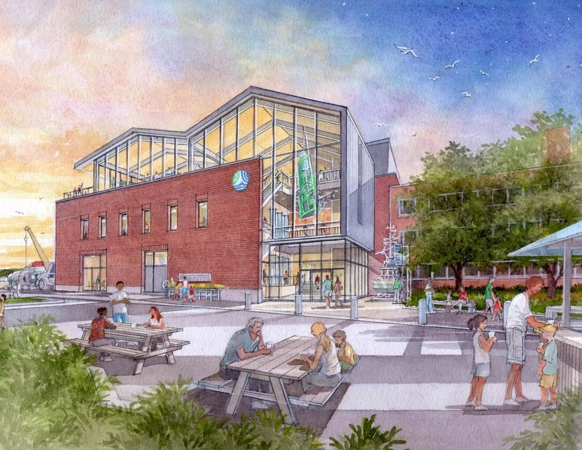
is shown in Figures 15 – 17 below from various vantage points across the site.
Figure 15 - Aerial View of the CWATER Site with New Waterfront Building and Dock Structure Shown
21Figure 16 - View of Proposed Public Entrance
Figure 17 - View of Reconfigured Test-Well
225.0 Project Schedule Overview
An 18‐month project schedule has been developed to refine the Dock design and Building design to a set
of completed construction documents ready to go out to bid. This process is anticipated to begin in Q1
2021 following the completion of Phase 2 of the Seaport Economic Council grant and continue to Q1
2022. The overall project schedule for the CWATER initiative is slated to run through the middle of 2026
depending on the dock approach selected and the availability of funding (Figure 19).
23Figure 19 - Conceptual Project Schedule
6.0 Permitting
Port modernization and waterfront construction projects in Massachusetts are required to undergo a
multitude of environmental reviews from regulatory authorities at the local, regional, state, and federal
levels in order to obtain required permits. By regulation, these reviews must proceed in an ordered
manner, as there are many prerequisites that affect the sequencing of the approvals and define the
overall permitting schedule.
The three main dock design options, described previously, will face different levels of regulatory
scrutiny. At the close of this Phase of work an Environmental Notification Form (ENF) has been
submitted to the Massachusetts Environmental Policy Act (MEPA) office. MEPA review is the first step
for the CWATER project permitting. Review of the ENF will involve a number of various state and federal
regulatory agencies. Following the ENF review more detailed and specific regulatory review will take
place at the local level.
7.0 Outreach and Engagement
7.1 Internal Engagement
Through the Feasibility Study process a variety of internal user groups have provided input and
perspective on the development of the CWATER proposal.
The Core Group included Rob Munier (project lead), Leslie‐Ann McGee (project manager), Rick Galat
(facilities), Court Clayton (development), and Jim Newton (consultant for WHOI Strategic Facilities
24Assessment). This group met on a weekly basis for the duration of the project and coordinated input and
engagement with the internal and external community members.
The Dock Advisory Group represents a broad cross‐section of the WHOI community with members
identified by Department Chairs and self‐selected at the outset of the CWATER project. DAG meetings
were held monthly with members providing critical insight and input on all aspects of the dock design
development. Furthermore, DAG members were instrumental in serving as conduits to the greater
WHOI community to solicit additional input and perspective from subject matter experts (SMEs) on
areas of specific concern or focus.
Beyond the Dock Advisory Group, the Core Group presented updates to each WHOI Department. These
sessions were focused on providing a comprehensive overview of the project, as well as soliciting
feedback on the emerging design direction and project approach.
7.2 External Engagement
The broader community including constituents from the Town of Falmouth and the village of Woods
Hole were engaged through the Community Advisory Committee. This committee provided a sounding
board for project development and has served as a vehicle for WHOI to share their planning efforts with
the broader community through the entire Strategic Facility Assessment (SFA) process. Members of the
CAC include the Woods Hole Community Association, Woods Hole Business Association, MBL, NOAA
NEFSC, Woods Hole Library, Woods Hole Museum.
Additionally, the sea level rise symposia described earlier served as a vehicle for broad‐based regional
and local input. These sessions were attended virtually by over 170 participants.
8.0 Outcomes and Next Steps
Phase 2 of the CWATER Design Study has further refined the design attributes, program requirements,
and innovative approaches for a sea level rise ready facility. These achievements provide the
underpinning for the next phases of design slated to begin Q1 2021.
Option 1A for the dock design has been selected to advance into the next phase of design in early 2021.
Early efforts will focus on validating the hydraulic lift design parameters and approach, as well as
evaluating a technical mockup of the interface enabling the deck to lift. These efforts are scheduled to
take place through May 2021 where the final design signoffs are scheduled to take place for the dock
element.
The building design is scheduled to advance into the Schematic Design phase early in 2021. During this
phase of design building systems and details around specific design elements will advance, as well as an
effort to refine the interpretative design and public function spaces in the facility. At the close of
Schematic Design, a more refined budget, schedule, and overall building design will come into focus for
approvals and permitting.
The MEPA Environmental Notification Form (ENF) submission resulted in a determination that an
Environmental Impact Report (EIR) will not be required for the CWATER project. This finding unlocks the
25next phases of permitting at the Federal, State, and Local levels and affirms the conceptual permitting
schedule outlined in Figure 19. Subsequent permitting efforts will focus on preparing the Notice of
Intent (NOI) and advancing that submission early in 2021 as well.
Thanks to the work completed under each of the two Seaport Economic Council Grants, WHOI has been
able to secure philanthropic funding to advance the next steps of the design process toward a shovel‐
ready project. The schedule milestone for completing a set of shovel‐ready documents is the close of Q2
2022.
26Appendices - Available upon request
Appendix A – CWATER Phase II – DOCK CONCEPT DESIGN STUDY (Moffatt & Nichol)
Appendix B – New Waterfront Building – Concept Report (Payette)
Appendix C – Climate Change Vulnerability Assessment (Woods Hole Group)
Appendix D – CWATER ENF Submission (Epsilon Associates)
Appendix E – Dock Design Alternative Review Summary (Various)
27!//\\\ WOODS HOLE
� -� OCEANOGRAPHIC
--:- INSTITUTION
rWATl=
--.... D
- -- - - ---
...__,
- - - - -- -- -You can also read