D'ARDÈCHE UNESCO Global Geopark - REVALIDATION REPORT - Geopark des Monts d'Ardèche
←
→
Page content transcription
If your browser does not render page correctly, please read the page content below
UNESCO Global Geopark
MONTS
D’ARDÈCHE
REVALIDATION REPORT
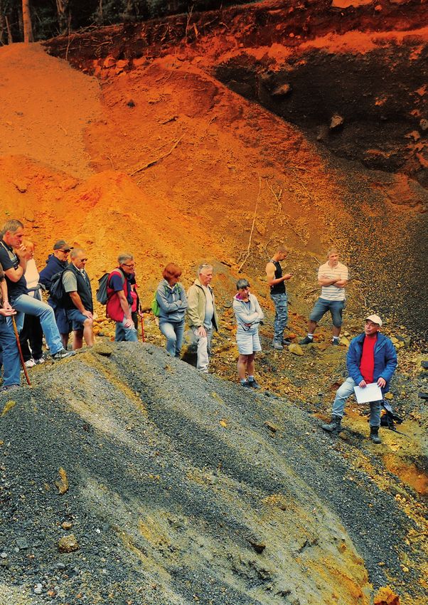
Figure 1 Rendez-vous
géologique at Géosite Suc
de Breysse
1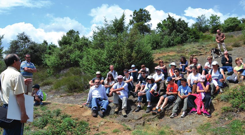
Name of UNESCO Global Geopark (UGGp) :
                                Monts d’Ardèche UNESCO Global Geopark
                                             Country : France
                      Person(s) responsible for the report : Nicolas Klee – Marc Lutz

A. General information
     Surface (km2)                                                           2442.5km²
     Population                                                              78 391
     Year of acceptance as UNESCO Global Geopark                             2015
     Year of membership in the Global Geoparks Network
                                                          2014
     (before the establishment of the UGGp label in 2015)
     Previous revalidation date(s) and name(s) of                            Evaluators for validation in 2014 : Dan Grigorescu,
     previous evaluator(s)                                                   Margaret Patzak
                                                                             Nicolas Klee
                                                                             Tourism technical office
                                                                             Geopark project leader
                                                                             nklee@parc-monts-ardeche.fr
     Contact person (name, position, e-mail)
                                                                             Marc Lutz
                                                                             Head of Department Biodiversity and spatial planning
                                                                             Geo-scientist
                                                                             mlutz@parc-monts-ardeche.fr
     Website (please provide URL)                                            www.geopark-monts-ardeche.fr

                                                                             https://www.facebook.com/parc.desmontsdardeche/
     Social media (please provide list of all channels                       https://twitter.com/PNR_MA
     used)                                                                   https://www.youtube.com/channel/UC8X69PVH-MnILkQN0ODTo-w
                                                                             https://www.instagram.com/parc_monts_ardeche/

    B. List of documents and annexes
     • Strategy for Monts d’Ardèche UNESCO global Geopark
     • List of Geosites
     • Map of Geosites
     • Map of Geopark achievements 2014-2018
     • List of geocultural sites
     • Annex detailing responses to the self-assessment
     • Letter of UNESCO recommendations following 2014 visit

    C. Cohesion of the area
     The responsible entity for the Geopark project is Syndicat mixte                    will lead to an increase in the Geopark’s surface area of + 162.5
     du Parc naturel régional des Monts d’Ardèche, which was created                     km² or + 3.5%. This will also facilitate the management of the
     in 20011. Thus, the Geopark area is exactly the same as the one                     territory by limiting enclaves and appendices. The consolidated
     of Parc naturel régional des Monts d’Ardèche, which was defined                     timetable for their integration is not known yet as it depends on
     through a decree of the Prime minister. The Geopark area                            national and regional validations over which the Geopark has no
     includes 150 municipalities that are clearly identified as forming                  control.
     the Park. By joining the Park, they join the Geopark.
                                                                                         The perimeter of Monts d’Ardèche GG also corresponds to a
     In 2018, 5 new municipalities will join the Park and therefore the                  coherent and a culturally well-identified territory.
     Geopark, under a new legal provision of the Biodiversity act. This

2    The legal entity managing the Geopark is Syndicat mixte du Parc naturel régional des Monts d’Ardèche. For more clarity, the terminology,
     1

     Monts d’Ardèche GG will be used to designate both the territory and the managing entity in the following text.
D. Improvements made on previous
  recommendations
 Monts d’Ardèche GG’s responses to the auditors were as follows (for further details, see corresponding
 annex) :

  RECOMMANDATION 1                                         construction while avoiding duplication.       which conduct research or training courses
                                                           Monts d’Ardèche GG is therefore not            in the Geopark (e.g. Université de Nancy,
 The Geopark website now lists all partners :              dependent on staff from universities.          Université de Nice, Université de Lyon), in
 http://www.geopark-monts-ardeche.                         Cooperation with all these partners allows     order to strengthen links and to improve
 fr/education-et-geologie-geopark/les-                     a regular, almost permanent, presence of       mutual contributions.
 acteurs-de-la-geologie-geopark.html                       geologists in the field, which is considered
                                                           satisfactory by all.

  RECOMMANDATION 2                                          RECOMMANDATION 3
 Monts d’Ardèche GG has deliberately                       Monts d’Ardèche GG has taken note of this
 chosen not to recruit a geologist but to                  recommendation and has made it a major
 favour local partnerships with structures                 focus of its work by building partnerships
 that have in-house geologists (e.g.                       with two universities (Université de
 Société Géologique de l’Ardèche (SGA),                    Bourgogne and Université de Clermont-
 Associations Clapas, Paléodécouvertes,                    Auvergne) and by funding research projects
 Centre permanent d’initiatives pour                       in its territory. The Geopark ichnology
 l’environnement du Velay (CPIE), les Amis                 study mobilized three Masters Courses
 du Mézenc). This allows to benefit from                   (Szewczyk, 2016; Szewczyk, 2017;
 an interesting quantitative panel, including              Dubied, 2017) which produced detailed
 many disciplines needed with respect to                   reports (see Annex 1). The Geopark will
 the diversity of the geological features                  also undertake an awareness-raising
 present in the Geopark. In this way, the                  campaign among non-partner universities
 Geopark promotes cooperation and co-                                                                                    Figure 3 - Scientific investigations
                                                                                                                         at the reptiles footprints site in
                                                                                                                         Ucel (Trias & Permien cévenol)

                                                                                                          RECOMMANDATION 4

                                                                                                          Monts d’Ardèche GG has integrated a
                                                                                                          new sedimentary site (Miocène), Vallée
                                                                                                          des Tuiliers in Mariac as a geosite. It has
                                                                                                          also added research on the Triassic and
                                                                                                          Permian sites in the study entrusted to
                                                                                                          Université de Bourgogne on footprints of
                                                                                                          reptiles and amphibians. An extension over
                                                                                                          the Carboniferous period is envisaged for
                                                                                                          the next labeling period 2018-2022.

 Figure 2 - Field course for tourism sector professionals in Jaujac

                                                                                                                                                                3
RECOMMANDATION 5                                        Scientific Committee. It entrusted              aim at providing visitors with a unique
                                                             Université de Bourgogne with an in-depth        approach to this major palaeontological
    Monts d’Ardèche GG continued to improve                  study. A partnership has been set up with       heritage.
    knowledge on this paleontological site                   municipality of Ucel for its valorization.
    considered as a priority by the Geopark                  The project will start in 2018, and will

    Figure 4 - Future design and equipment at the reptile’s footprints site in Ucel

     RECOMMANDATION 6                                          into English. Geopark road signs are under      RECOMMANDATION 7
                                                               construction and will be installed in 2018.
    Signs and panels at the entrances of the                   The map and booklet «all about Monts            In accordance with this recommendation,
    geosites sites clearly mention the GGN logo                d’Ardèche Global Geopark» have also been        Monts d’Ardèche GG created or renewed
    - and the UNESCO logo for the latest ones.                 translated into English, which is spoken by     interpretive trails that combine geodiversity,
    All texts of the panels have been translated               the majority of foreign visitors.               biodiversity and cultural heritage. These
                                                                                                               include notably:

                                                                                                               • The trail “entre mer et montagne”
                                                                                                               [between sea and mountains]» in
                                                                                                               Saint-Etienne-de Boulogne (around Roche
                                                                                                               de Gourdon), which evokes history, fauna
                                                                                                               and flora, in addition to geological history ;

                                                                                                               • The path of Rocher de Brion which
                                                                                                               evokes landscapes, history and flora ;

                                                                                                               • The path at Mont Signon which evokes
                                                                                                               the geological history and the history of the
                                                                                                               phonolite quarry

     Figure 5 - Géototem at the basaltic lava flow geosite in Jaujac

4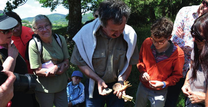
RECOMMANDATION 8                                         • Monts d’Ardèche GG is member of the          and which is presenting its collection to
                                                          association «Passerelles Patrimoines»          the public. He is a member of the Regional
Number of sites (e.g. belvedere des                       which aims to develop learning trips in        Geological Heritage Commission which will
coulées in Fabras, Coupe de Jaujac...)                    Ardèche. A packaged trip «From earth           host, in cooperation with the Geopark, an
have been managed with special                            to heaven: volcanism and astronomical          internship dealing with the valorization of
attention to vegetalization problems, and                 energies» was thus built. For further          geology through itinerancy.
the first specific logging actions have                   information : http://passerelles-
been conducted there. However, Monts                      patrimoines-ardeche.com/sejours/de-
d’Ardèche GG is fully aware of the problem,               la-terre-au-ciel-volcanisme-energies-          RECOMMANDATION 12
and systematic actions to clean up the lava               astronomie
flows will be planned in the next program.                                                               Monts d’Ardèche GG has developed
                                                          • Following actions of Association Pôle        new tools for the valorization of mineral
                                                          Haroun Tazieff (PHTVV), the operator           waters: a video promoting mineral waters
 RECOMMANDATION 9                                         of St Julien-Boutières basalt quarry is        and a water bar, including geological
                                                          developing infrastructures to welcome          explanations. A specific exhibition on
Since the certification, Monts d’Ardèche                  school groups, in connection with Monts        mineral and thermal waters will be held
GG has implemented two new activities for                 d’Ardèche GG’s activities.                     between 2018 and 2022. In addition,
schoolchildren and educational partners :                                                                thermal baths and spas are currently
                                                          • A «dinosaur» learning trip is also           being renovated and extended, especially
• The Geopark school competition, which                   currently under development.                   in Vals les bains with a major extension
aims to encourage classes to produce an                                                                  and renovation work.
innovative project over the volcanoes of
Monts d’Ardèche, with the possibility to                  RECOMMANDATION 10
win an end-of-year trip.                                                                                 RECOMMANDATION 13
                                                          This issue has been resolved with the
• Monts d’Ardèche GG is building in                       partner in question. In the application form   The association Ecole du vent and Monts
2017-2018 new pedagogical mediation                       for the use of the «Geopark Partners» logo,    d’Ardèche GG are currently developing
tools for and with educational stakeholders,              it is specified that any partner undertakes    an interpretive trail about the basaltic
to promote the use of local concepts and                  not to sell geological objects.                lava flows of Saint-Clément, the main
heritages in pedagogical activities. One of                                                              thread being “l’envol” [the flight], which
the aims of this action is also to build a                                                               will include pterosaurs stories.
network of Geopark ambassadors.

                                                                                                         RECOMMANDATION 14

                                                                                                         Monts d’Ardèche GG actively participated
                                                                                                         in all GGN meetings and promoted the
                                                                                                         GGN.

                                                          RECOMMANDATION 11

                                                          Paléodécouvertes, one of Monts d’Ardèche
                                                          GG’s partner association, is not the owner
                                                          of the evoked collection, which belongs
                                                          to M. Bernard Riou, who is an employee
                                                          of the said association. He welcomed the
                                                          auditors in 2014.

                                                          Bernard Riou and Paléodécouvertes
                                                          continue to collaborate with scientific
                                                          research. B. riou is an associate of
Figure 6 - Volcano model created for the Volcano school   Muséum de l’Ardèche, created in 2016
competition

                                                                                                                                                       5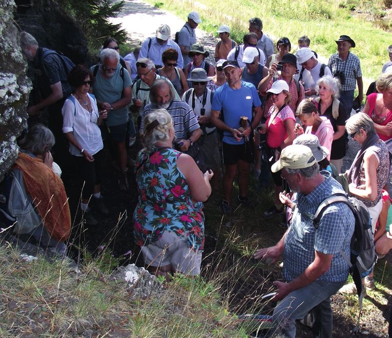
E. Verification of UGGp criteria
     E.1 Territory
      E.1.1 GEOLOGICAL HERITAGE AND CONSERVATION

     Monts d’Ardèche GG displays a remarkable slice of the geological history of a large part of Europe
     since 550 Mo years, i. e. from the Paleozoic (Primary era) to present days, including that of its two
     great orogenesis: the variscan (or hercynian) cycle and the alpine cycle.

      1. Metamorphic and plutonic rocks              and migmatites on the roof of which          3. The spectacular volcanic
      make up the bulk of the geological             remain panels of metamorphic rocks           eruptions in the Geopark territory
      formations in the Geopark. They                (mainly gneiss).                             have appeared as a result of the
      correspond to the deep roots of                                                             repercussions of the surrection of
      the variscan chain, an incredible              These crystalline rocks, melted at several   the Alps at the Cenozoic (Tertiary
      mountainous chain with peaks                   tens of km deep before rising to the         and Quaternary eras), raising then
      reaching more than 6000 m high,                surface, form the southern edge of the       fracturing the base of Massif central,
      barring the Pangea at the end of the           largest French granite complex.              thus reactivating ancient faults of the
      Paleozoic :                                                                                 variscan base, and generating the
                                                                                                  diversified volcanism of Ardèche :
      In the south of the Geopark, Cevenol           2. The sedimentary cover of the old
      schists correspond to sediments                variscan bedrock, which is found on          • “Pays des sucs du Velay”, the largest
      deposed on the northern margin of              the southern edge of the Geopark,            phonolitic package in Europe (made of
      Gondwana, at the Cambro-Ordovician             reflects two contexts and two                the so-called «stones that ring»), exposes
      age. Their structuring is developed with       generations of sediments :                   these unique landscapes of domes, pitons
      Carboniferous (340 Mo years).                                                               and other very varied forms.
                                                     • The continental erosion sediments
      The metamorphic and granitic rocks             from this ancient chain constitute a wide    • The «land of the young volcanoes of
      of Vivarais and Velay, in the centre and       sandstone platform on the southeast edge     Vivarais», whose very long flows (up to
      north of the Geopark, represent the deep       of the park, deposited from Carboniferous    21 km) which sometimes go up the valleys
      roots of the inner zone of the variscan        to Triassic;                                 (Thueyts), superimpose themselves (Pont
      chain. They result from a stacking of                                                       de Labeaume), or draw imposing basaltic
      slicks formed during the major phase of        • Marine sediments, deposited during         colonnades, which are sometimes jointed.
      continental collision at the Devonian (360     the invasion of the Tethys Sea (Alpine
      Mo years), which is accompanied by a           Sea), partially covered the roots of the     In these two sectors, the territory also
      catazonal metamorphism. Following this         planed and sagged variscan base. On          presents numerous phreatomagmatic
      collision, an episode of distension affected   the south-eastern facade of the Geopark,     volcanoes (maars). As they form wide
      the area with medium carboniferous             the posterior alpine folding has left        depressions, these are easily visible in the
      material (320 to 300 Mo years), and was        corrugated and tilted jurassic marl and      landscape, and are now home to lakes or
      accompanied by a bulging and melting of        limestone panels.                            peat bogs.
      the deep crust that generates the «Velay
      dome»: a vast group of anatexic granites

6
Paleomagnetic studies conducted on           of the Quaternary, and finally by 4)            • Ray-Pic waterfall and its 21km lava
the volcanoes of Bas Vivarais (Rochette      volcanism which may have disrupted              flow, one of the longest in Europe, is
et al, 1993), make it possible to affirm     the encroachment and led to localized           particularly spectacular;
that this volcanism is less than 780,000     changes of the tracing of rivers. This
years old and is divided into 3 very short   erosion also took advantage of the many         • The whole massif du Mezenc-
phases of activity (each phase lasting for   lithological contrasts to create an original    Gerbier, made up of ca. 10 geosites,
one century at most) separated by rest       relief, revealing many volcanic structures      which is the largest phonolitic massif in
intervals of 33,000 to 50,000 years (based   initially buried in the underlying substrate.   Europe
on previous TL and 14C dating coupled        Quaternary cold periods achieved the
with morpho-stratigraphic observations).     work by leaving on the slopes many              • Mofette de Neyrac, one of the rare
The volcanoes of each of these 3 phases      remarkable formations such as the scree         European examples of mofette ;
are grouped together along 3 axes, failed    that surrounds “sucs” or the amazing
N145°, and staggered from the north (the     «rivers of stones» of the Mezenc massif.        • Maar of Vestide du Pal, the largest
oldest episode) to the south (the most                                                       phreatomagmatic crater in Europe.
recent one).                                 During the last alternation of glacial-
                                             interglacial episodes, humans began
The latest thermoluminescence dating data    to leave their mark on the Geopark’s            Conservation measures :
(Guérin and Gillot, 2007) confirm these      natural landscapes: shelters under
three phases and place them at 166,000       rocks or caves, dry stone terraces,             With the exception of fossil sites, geosites
+/- 15,000 years, 78,000 +/- 5,300 years     lauze quarries, irrigation, clearing and        of Monts d’Ardèche are rarely in danger
and 45,400 +/- 3,200 years.                  reforestation, mining activities... Near        and require little protection.
The most recent work (Nomade et al,          the Geopark, the painted cave at Pont
2014; Sasco, 2015; Nomade et al,             d’ Arc - Ardèche is home to the oldest          In France, sites rarely benefit from
2016) based on the application of the        cave paintings of humanity known to date.       legal protection for their geological or
40Ar/39Ar method lead to the distinction     Assumptions are currently being made            geomorphological interests. However, nine
between an old northern sector (buildings    about the representation of volcanic            geological sites within the Geopark are
dated between 206,000 +/- 13,000             eruptions (taking place in the Geopark)         protected by law. Listed as «sites inscrits»
and 170,000 +/- 23,000 years) and a          in the frescoes of Chauvet Cave.                or «sites classés», with respect to their
younger southern sector (buildings dated                                                     geological or landscape heritage value
between 40,000+ /- 6,000 and 15,000                                                          and their quality as «natural monuments».
+/- 11,000 years).                           The numerous peat bogs of the                   These sites cut across geosites in the
                                             massif constitute remarkable natural            Geopark:
Given the margins of error and differences   environments (often managed in the
between dating methods, further              frame of EU - Natura 2000 network) and
investigations need to be conducted.         palaeoenvironmental archives that bear          The five “sites classés” :
                                             witness to the human-nature relations
Old reactivated faults favour the            since the Holocene. Their potential is still    • Basalt flows of Pont du Diable in
emergence of mineral springs (often          largely untapped.                               Thueyts;
gaseous) and thermal springs (exploited                                                      • Massif du Mezenc;
for their medicinal properties).                                                             • Mont Gerbier de Jonc;
                                                                                             • Rocher du Fromage in Antraigues;
4. Glaciations and men complete the          Sites of international                          • Ray Pic cascade;
picture
                                             geological importance :
The Plio-quaternary digging of the valleys
has been influenced by 1) the rise of the    Monts d’Ardèche GG has several sites of
Cevennes edge, 2) the Messinian crisis       international geological interest.
which momentarily but significantly
lowered the level of the Mediterranean,      Examples are the following :
3) the gradual cooling of the climate,
then the inter-glacial/glacial alternation   • Lava flows of Saint-Clément, where
                                             12 basaltic flows superimpose ;

                                                                                                                                            7
The four «sites inscrits» :                  a particular attention to the geosite of        New geological sites
                                                 Jaujac volcano (Coupe de Jaujac), which
                                                 is directly managed by the Geopark team.
                                                                                                 within the UGGP and
    • Jaubernie cave;
    • Basaltic flows in Antraigues                                                               integrated in the protection
    • Rocher de Gourdon                          The Geopark team also completed the             and management plan
    • Pourcheyrolles Castle                      management plan for the Mont-Gerbier-
                                                 de-Jonc geosite, one of the Geopark’s           Since 2014 certification, two new
                                                 main geosites, with a specific aim at           geological sites have been integrated as
    In addition, a (geotope protection order)    reconciling development and nature              geosites: Vallée des Tuiliers in Mariac,
    is currently being elaborated for Ucel       protection.                                     on which an interpretive trail telling the
    geosite. The same type of protection                                                         geological and human history of this
    measure may also be implemented at           On geosites of Arcens and Soutron, the          valley is currently being constructed, and
    Cirque de Naves, after consultation with     partner associations of the Geopark             Rocher de Soutron, which was designed
    local communities.                           (Arcens Amitié développement (ARCADE)           for public attendance in 2017. These two
                                                 and PHTVV) and the municipalities have          sites combine geological heritage and a
    Geosite management in Monts d’Ardèche        actively undertaken the restoration of the      very striking human history.
    mainly concerns municipalities and           volcanic stone buildings.
    private landowners. Therefore the
    Geopark endeavors to coordinate efforts      On other geosites, protection measures
    to develop geosites in order to better       have been taken to protect fauna
    take into account the protection aspects     (example of the valorization of the geosite
    and harmonize the communication/             of the Chalencon quarry, the interpretation
    awareness raising tools used on the          equipment is removable and is removed
    territory. Agreements have been signed       during the nesting period of the peregrine
    with concerned municipalities for the        falcon that nests there). Overall, 9 geosites
    maintenance of roads and information         are managed either through Natura 2000
    devices.                                     or Espaces naturels sensibles policy.

    However, Monts d’Ardèche GG gives

     E.1.2 BOUNDARIES                              E.1.3 VISIBILITY
     The perimeter of the Geopark is clearly     Each year, Monts d’Ardèche GG publishes         Geopark logos are used on all panels
     defined in all communication tools          a discovery map presenting touristic sites      and interpretation tables on all geosites
     edited by Monts d’Ardèche GG and its        on the front, and geosites on the back.         accessible to the public.
     partners. All municipalities belonging to   A discovery guide is also published
     Parc naturel regional have an entrance      every two years with a specific Geopark
     panel indicating that they belong to the    section. Overall, the logo is used on all of
     Park. On the roads entering the Geopark,    the Park’s communication tools aimed at
     a road sign, in accordance with national    the general public and tourists. The Park
     traffic regulations, informs drivers that   regularly holds fairs and participates in
     they enter the Parc naturel régional des    events promoting its territory in which
     Monts d’Ardèche. In 2018, this sign will    it systematically mentions the Geopark.
     be doubled with a specific Geopark sign.

8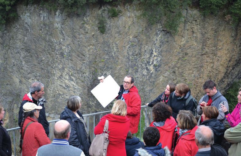
E.1.4 FACILITIES AND INFRASTRUCTURES

The creation and improvement
of new infrastructures for
discovering the territory
has been the main focus of
Geopark’s work over the last
4 years. The objective was to
enable as many visitors as
possible to discover most of
the major geological sites with
the best security standards.
Of the 53 geosites identified
by the Geopark, 49 are now
permanently accessible to the
public.

These 49 sites are identified by 54
geototems located at the entry points of the
sites. These geototems briefly present the
site and its geological history in French and
English on the front, and a map of all the               Figure 7 - Welcoming the GEOLE national meeting, mediation section of Société géologique de France, at the
geosites as well as a geological timeline                new pathway at Roche de Gourdon
on the back. According to mobile phone
network possibilities, an NFC chip allows
access to real-time tourist information.
                                                                                                                 En 2017 :
In addition to signs and trail marking                                                                           • Trail “Sentier des Tétines” at Vernon,
equipment, the Geopark and its partners                  En 2016 :                                               • Vineyard trail in Rosières,
have also developed new interpretation                   • Geological path of Rocher de Gourdon,                 • Welcome panels on the Craux geosite,
equipment for geosites.                                  • Renovation of equipment at Rocher de                  • Renovation of the Mont Signon trail,
                                                         Brion geosite,                                          • Replacement of the Roche de Cuzet
En 2015 :                                                • Development of an educational path at Bois            interpretation table,
• The landscape interpretation table at the              du Four site in Vernoux, with schoolchildren            • Implementation of a new orientation table
lava flows of Jaujac,                                    of the secondary school,                                at cirque de la Croix de Boutières
• Replacement of Croix de Boutières                      • Site design of the Chalencon quarry.
interpretation table,                                                                                            En 2018 :
                                                                                                                 • Interpretation trail of Coulées de Saint-
                                                                                                                 Clément,
                                                                                                                 • “Vallée des tuiliers” trail in Mariac,
                                                                                                                 • Interpretive trail of Cirque de Naves,
                                                                                                                 • Renovation of the orientation table at
                                                                                                                 Volcan du Don geosite,
                                                                                                                 • Belvederes at Rocher of Borée and at
                                                                                                                 Mount Mezenc.

Figure 8 - Implementation of a belvedere at Lava flow Geosite in Jaujac

                                                                                                                                                                      9
The artistic path
     «Le Partage des eaux»
     The watershed line between the
     Mediterranean and the Atlantic crosses
     the Geopark over 120 km. It intertwines
     with the national hiking trail GR7, which
     crosses France from the Vosges to the
     Eastern Pyrenees. This symbolic and
     geological line has inspired six artists, a
     designer and three landscape architects.
     The itinerar y includes admirable
     geological sites (Mont Gerbier-de-Jonc)
     and emblematic heritage buildings
     (Chartreuse de Bonnefoy, Abbaye de
     Mazan, Tour de Borne, Abbaye de Notre-
     Dame des Neiges), that host contemporary
     artworks created by internationally
     renowned artists, who love to work
     outside spaces devoted to art, with their
     own unique disproportion.

     Figure 9 - La Tour à eau, artistic artwork included   Figure 10 - Le Phare, artistic artwork in Partage des eaux project
     in Partage des eaux project

                                                           line, artist Gloria Friedmann imagined                   caravels that crossed the Atlantic Ocean.
     Thus, at Chartreuse de Bonnefoy, artist               a lighthouse between the Atlantic and                    The «planetary gardener» Gilles Clément
     Stéphane Thidet imagined an artwork                   the Mediterranean. The remains of                        imagined a water tower built of phonoliths,
     that fits in smoothly with the 18th                   the Cistercian Abbey of Mazan host an                    the volcanic rock present at Mont Gerbier.
     century facade, playing on transparency               anamorphosis of Felice Varini. At Abbaye                 Finally, since summer 2016, a first part
     and reflection of the passage of time and             Notre-Dame des Neiges, artist Huang                      of Olivier Leroi’s work, installed near the
     of seasons. At Borne, on the GR7 ridge                Yong Ping calls the imagination of the first             Gerbier-de-Jonc site house, can also be

10
discovered. Mont Gerbier intends to promote it through scientific
The power of attraction and fascination of and artistic approaches. As a territory
the watershed is also the starting point for interpretation centre museum, Musée des Vans will offer its
Gilles Clément’s proposed filigree work, (Maison de site du visitors an interdisciplinary approach to
in partnership with IL Y A’s landscapers regional heritage.
who help reveal the watershed line with
Gerbier)
“mires”. Hikers and mountain bikers who Next development steps are the
This new equipment was completed during
cross the Park following or crossing this following :
summer 2017. Maison de site du Gerbier,
line will find on their route original outdoor • Implement the renovation of the building
at the foot of the most famous geosite of
furniture designed by Eric Benqué and and scenography (including fund raising
Monts d’Ardèche, welcomes the public
made of local natural resources (chestnut activities);
and explains this unique place. Through
timber) and with local know-how. As for • Conduct scientific research based on
models, slideshows and films, geology,
motorists and cyclists, the collective of the available collections, to increase,
volcanism, the birth of the sources of the
artists Toplamak has designed a GPS refine and communicate knowledge to
Loire and the creation of the watershed are
(GeoPoéticSociety) to accompany travelers the general public;
explained. At a turn of the museographic
from one site to another while telling them • Pursue and disseminate the cultural and
itinerary, three excursions are proposed:
about the landscape through space and pedagogical program of the museum.
«To the mysterious sources», «On a unique
time.
mountain» and «In the heart of surprising
landscapes”. The interpretation center is Ucel geosite:
open from spring to autumn and is free of conservation and
charge. It also houses a «Welcome Area»
of Department de l’Ardèche which aims to valorization of reptile’s
give information about the whole territory. footprints
Les Vans Museum The inventory of sites with traces of
dinosaurs was notably planned to select
Founded nearly 150 years ago, the a site that could be used for public
museum shelters various collections in awareness activities, with complete safety
geology, archaeology and ethnography in for both visitors and the fossil heritage.
order to document and exhibit the region’s On the basis of the inventory and the
natural and cultural heritage. specific characteristics of each site, the
Ucel site was selected to be valued. It is
According to the program adopted a private site, but municipality of Ucel is
in 2014, the museum’s team has currently offering to buy the plot. Design
reached the following targets : of equipment and management options
• drawing up the inventory of collection ; have been validated by scientists, the
• setting up of a public service dealing municipality of Ucel and Monts d’Ardèche
about communication, mediation and GG. Equipment should be installed by the
organization of events ; second half of 2018.
• elaboration of a scientific and cultural
project including the restoration of Ferme de Lagas
the building and a new design of the
permanent exhibitions This site was visited during the audit
Figure 11 et 12 - New equipment : How to read and 2014. Ferme de Lagas in Borée is
understand the landscape ? - watershed - Partage The museum is now seen as an active gradually becoming a new interesting
des eaux project
and living cultural institution. A cultural place for cultural activities in the Massif.
program is proposed with temporary A series of conferences animated by Les
exhibitions (frequently in cooperation Amis du Mézenc are organized on the
with Monts d’Ardèche GG ), workshops spot, together with a permanent exhibition
for children and cultural events (concert, entitled «Au jardin des phonolites - Les
reading, theatre...). géosites de la commune de Borée». New
However, the museum needs to reinvent equipment will complete the Farm in 2018
itself and to achieve a true metamorphosis to make conferences more comfortable.
to further develop and evolve.
The museum’s renovation project identifies
the notion of «landscape entity» as the
guiding thread of the exhibitions and
11E.1.5 INFORMATION, EDUCATION AND RESEARCH
Information
Journal du Parc is published every six
months and provides the public with
various information on the Park’s activities
and its heritage. In each issue, activities
related to the Geopark label are presented
and each issue also features a geosite
walk.
Les pieds dans l’parc is a video and radio
news magazine developed with local radio
stations and a local film association.
This magazine deals with many topics
highlighting local initiatives and
heritages. Three issues in particular have
been devoted to the Geopark: in 2015:
dinosaur’s footprints and the geosite of
Cascade de Baumicou, in 2016: Neck de
Craux and the settlement of farmers on
the volcano, and in 2017: Rendez-vous
géologiques – public awareness program.
As a general rule, the Geopark
systematically communicates to the press
all the news in which it is engaged and
carries out a selective press review.
Promotion
Monts d’Ardèche GG publishes every year
various promotional tools for promoting Figure 13 - Exhibition : Les 7 couleurs du temps at Ferme de Bourlatier exhibition centre
the territory and the Geopark label, e.g.
the map of the Park composed on the
front of a classic tourist information map,
and on the back of the map geosites. Exhibitions
2016 : Exhibition «Au jardin des phonolites
Every 2 years a discovery guide is also - Géosites de la commune de Borée»
published. It presents all the partners’ 2014 : Realisation of the exhibition «Les
07 couleurs du temps» [The 07 colours organized by the association Les amis
offers, a large part of which being devoted du Mezenc, with support from Monts
to the Geopark label.. of time ] (installed for 3 years at Maison
du Parc and Ferme de Bourlatier). This d’Ardèche GG and municipality of Borée.
exhibition welcomed more than 12 000
visitors and is now available in a mobile 2017 : Exhibition “De part et d’autres “[On
and lighter version. both sides]: exhibition of photographs
of landscapes of the watershed, by
2014 : Creation of the exhibition photograph François Lacour with an
«Geobiodiversité dans les Monts introduction by members of the Geopark
d’Ardèche»: This exhibitions mixes the Scientific Committee.
geological heritage and the emblematic
species (fauna and flora) of the territory, 2017 : All you need to know about
with photographs by local artist Simon Monts d’Ardèche global geopark: mobile
Bugnon. exhibition presenting the label, the territory
and its geological history.
12Edition
2014 : new edition of Guide géologique de l’Ardèche (ed.
Omniscience)
2016 : edition of Topoguide « Tour des Cévennes et de la
Montagne ardéchoise » (ed. FFRP)
Printemps 2017 : édition of the booklet « Tout savoir sur le
Geopark des Monts d’Ardèche », french version, edited by
Monts d’Ardèche GG
Automne 2017 : edition of the booklet « Learn all about The
Monts d’Ardèche UNESCO Global Geopark », english version,
ed. Monts d’Ardèche GG
2018 : Les plus belles balades du Parc des Monts d’Ardèche. Figure 14 : Brochure Tout savoir sur le Geopark
Ed. Glénat. UNESCO des Monts d’Ardèche and Geopark hiking
guide
Awareness raising
Since 2014, Monts d’Ardèche GG has set up program of These events are regularly co-organized with communes and
events around its geological heritage called «Les rendez-vous communities of communes.
géologiques», which has brought together 2619 participants
out of 58 events since their launch. These meetings are Since 2017, programming has had a thematic focus. In 2017,
generally led by local geologists and sometimes by speakers it dealt with the concept of the watershed and crossed the
from outside the territory. The aim is to raise awareness of the viewpoints of geologists and artists in the same territory.
general public about the interest and knowledge of the geological
900
heritage of the Geopark and its associated heritages.
800
700
Fréquentation des «Rendez-vous géologiques»
600 en nombre de participants
500
900
400
800
300
700
200
600
2014 2015 2016 2017
500
400
300
200
2014 2015 2016 2017
Nombre d’évènements «Les rendez-vous géologiques»
organisées ou coordonnées par le Geopark
18
17 Figure 16 - Brochures « Les rendez-vous
16 géologiques »
15
14
13
1218
1117
1016
915
814
13 2014 2015 2016 2017
12 Figure 15 - Evolution of Rendez-vous géologiques
11 (number of events organized and number of participants) 13
10
9Research to reconstruct the paleoenvironmental 300 of them have been modeled using
and tephrostratigraphic micro-regional a 3D numerical modeling, and about ten
Since the UNESCO GG certification and context of the Upper Pleistocene. moulds have been made. One of the sites
in accordance with the recommendations will undergo geotourism development.
of the auditors, Monts d’Ardèche GG Axis 2 «Recherches géoarchéologiques This work was accompanied by 3 Master
undertook to develop research activities dans le très haut bassin de la Loire » student’s internships and the setting up
by both local and university students. [Geo-archaeological research in the of an active working group involving local
very high upper part of Loire basin] stakeholders. The Geopark and Université
The Geopark signed partnership focuses on the morphological and hydro- de Bourgogne have also developed a PhD
agreements with Université de Bourgogne sedimentary evolution of basin heads at project about the inventory and digital
- Franche-Comté and with Université the Holocene scale under the influence of valuation of dinosaur footprints, but so
de Clermont-Ferrand – Auvergne, natural and anthropogenic pressures in far no funding could be made available
and financed research activities in its the context of medium mountains. for this project.
territory around two major themes:
geoarcheological research and the
inventory of sites with traces of dinosaurs The Museomix
and other reptiles. Inventory of reptile’s experience « Ardèche
footprints mix Camp »
The region covered by the Geopark has In 2016, Monts d’Ardèche GG organized
Geoarcheological an exceptional paleontological heritage, with partners a so-called «Museomix»,
research notably with footprints of dinosaurs a creative marathon locally named
and other large reptiles of the Triassic «Ardèchemixcamp». Ardèchemixcamp
Geomorphological and geoarchaeological Period, which have been studied since was a collaborative and participative
research carried out in the upper Loire the 1960s by the Biogeosciences event, with an objective to design
basin (by Université de Clermont- Laboratory of University de Bourgogne. prototypes of digital mediation that would
Auvergne) has been supported since The partnership consists of drawing up allow to see a landscape or a territory
2016 by Monts d’Ardèche GG. They a detailed inventory of footprint’s sites, differently. Scheduled from November
develop along two complementary axes. carrying out a scientific analysis of the 25 to 27 at Le Pradel University campus
recently discovered tracks, conserving (Mirabel), it allowed the realization of an
Axis 1 « Derrière une chaussée de this geo-heritage, enhancing the value augmented reality prototype of the site
géants, les archives des climats de notre of suitable sites on a long-term basis with traces of dinosaurs in Ucel. The
Préhistoire. Etude géoarchéologique and disseminating the scientific results Geopark is currently seeking funding to
pluridisciplinaire » [Behind a giant’s to the general public (awareness raising turn further develop this prototype into
causeway, the archives of climates of activities, exhibitions, conferences). reality.
our Prehistory. Multidisciplinary geo-
archaeological study], aims at exploiting After a year and a half of work, about
the sedimentary archives of recent fifteen sites have been referenced, with
volcanic dams in the Lower Vivarais more than 600 fingerprints inventoried.
Figure 17- The Museomix experience : a virtual reality prototype
developed for Ucel gesosite
14E.2 Other heritage
E.2.1 NATURAL HERITAGE
Monts d’Ardèche shelter a The Park has 1,489 species of indigenous the yellow-bellied toad Bombina variegata
very rich natural heritage. or assimilated native vascular plants, • The cliffs, present all over the territory
including 180 rare and/or protected and of different geological origins, allow
The strong physical species and nearly 400 bryophytes, 29 the presence of the peregrine falcon
constraints (steep slopes, of which are remarkable. With 69 species Falco peregrinus, the golden eagle Aquila
steep-sided valleys) have of dragonflies, 145 species of diurnal chrysaetos and the owl Bubo bubo to nest
in fact preserved it from butterflies and 70 orthopteran, more in a particularly adapted biotope
certain human activities than 180 species of birds, 170 mammals
including 27 bats and 26 small mammals, The territory is also covered by 6 areas
with negative impacts with 25 species of fish, 13 amphibians classified as Espace naturel sensible
for nature conservation: and 18 reptiles, the animal diversity within (ENS). Actions to preserve the most
intensive agriculture, strong the Geopark is remarkable. remarkable natural sites have been
urbanization, development of undertaken by the Park and its partners
large infrastructures, etc.... in recent years (see LIFE programs on
The geological diversity of the Mont Mezenc, Tanargue and Plateau
territory has thus created very de Montselgues, Natura 2000 sites,
different ecosystems : Biological Reserves, ENS sites). Monts
In this context, natural and semi-natural d’Ardèche GG is currently applying for a
areas habitats occupy large areas and • Peat bogs, mainly present in the Life project for the conservation of aquatic
host a great diversity of environments mountainous area and formed on acidic habitats and species.
and species. The cover is concerned by soils and sometimes in the heart of
2 biogeographical domains (continental, maars. These rare and localized habitats The current forest cover in Monts
Mediterranean). Thus the environment are home to typical species such as d’Ardèche is ca. 60% with more than
is subject to various climatic influences Drosera (small carnivorous plant) or 110,000 ha of forest. This makes Monts
(mountainous, Atlantic, continental and Phengaris alcon (small blue butterfly) or d’Ardèche one of the 10 most wooded
Mediterranean) with a high altitudinal Somatochlora arctica (dragonfly). natural parks in France. The Park gathers
gradient (from 170 m to 1 753 m) and about 45% of all forests of Ardèche, and
a wide variety of geological contexts • Grassland and subalpine shelters a greater proportion of public
(plutonic, metamorphic, sedimentary, moorlands, present on the summits of forest (14% against 10%, i. e. 14,500
volcanic rocks). This situation has resulted Sucs, they shelter a particular flora which ha), and also the majority of State forests
in a high level of biodiversity: 40 types of is present in the Alps or the Pyrenees. in Ardèche) (10,500 ha, i. e. about 75%
natural habitats of EU Community interest Saxifraga prostii is for exemple present of them).
have been identified, 1,400 plant species, in certain scree, and it is also possible
including 30 protected or endemic (only to to find Lycopodium alpinium, Rosa
be found in Cevennes or Massif Central) pendulina, Arctostaphyllos uva-ursi or
and 50 remarkable animal species. Jacobaea leucophylla. The blue rock trush
Monticola saxatilis and Apollo butterfly
The Park has identified more than Parnassius apollo are also present in
26,000 ha of outstanding natural these environments.
areas, corresponding to ca. 68 sites.
194 plant communities have been • Rivers and their canyons, where
described, of which 38 are recognized several heritage species live in mineral
as being of Community interest, 7 of environments. These include the white-
them being considered as EU priority clawed crayfish Austropotamobius
habitats. pallipes, the common otter Lutra lutra or
15E.2.2 CULTURAL HERITAGE
The territory of Monts d’Ardèche • A remarkable built heritage, with forms de la châtaigne d’Ardèche, Maison du
shelters cultural heritages that make and materials highlighting an incredible chataignier, Maison du Fin Gras, Musée du
it unique and famous : capacity of human communities to adapt Vivarais protestant, Ardelaine, les Fermes
to the relief, the climate, and to use a de la montagne, the 3 “moulinages” open
• The chestnut grove, which profoundly singular geology: traditional habitat, to the public...). Monts d’Ardèche GG also
marks the landscape and the life of this hydraulic heritage (water channels, coordinates and supports the cultural and
territory. It is one of the most visible and mills...)....). , castles dominating valleys, agricultural events that set the pace in these
transversal elements of the culture shared industrial buildings (“moulinages”) or areas, e.g. Castagnades festival (35,000
by inhabitants of Monts d’Ardèche; “calades” (traditional pavements, bridges...) visitors), Fête du Fin gras (5,000 visitors),
all contributing to a strong and common marché de la myrtille (3,000 visitors)
• Dry stone terraces built by men to enable identity of the territory;
cultivation and life on the slopes, which are Near the Park in its southern part, the so-
«permanent» in both time and space; • Agricultural, handcraft and industrial called Chauvet Cave, near Pont d’Arc on
know-how, which has been perpetuated the Ardèche River is the oldest painted
• Water that is omnipresent in the territory, over decades and which allows this cave known to date. Beside this exceptional
with nearly 3000 km of watercourses and territory, for example, to benefit from heritage, Monts d’Ardèche GG implemented
the emblematic sites of the sources of four protected origin labeling (Fin gras du the Artistic project “Partage des eaux”,
Loire and Ardèche rivers. It has shaped Mézenc, Picodon, Chestnut of Ardèche, which highlights contemporary creation
landscapes and played an important role green lentils of Le Puy). as an echo to Palaeolithic creation.
in the agricultural and industrial history of
the territory. It still plays an essential role For all these heritages, Monts d’Ardèche
today as it contributes to maintain activities GG supports museums as part of its
(agriculture, industry, tourism); network (Castanéa, Espace Découverte
E.2.3 INTANGIBLE HERITAGE
A strong rural culture The «civilization of the chestnut tree» has able to develop a creative and ingenious
greatly contributed to this collective reality. spirit. In this sense, they have often been
This culture is primarily due to the essential This culture is promoted in various sites «pionners» in the technical (example
role played by agriculture, particularly in open to the public (28). of agricultural know-how...), economic
the hillside and mountainous areas. This (example of the textile sector), or societal
(example of peasant-workers or the” return
medium mountain territory was designed A land of innovation since to the land” of the 1970s). This land has
and built by the hand of man. Beyond the
landscapes, agriculture has shaped the always been nourished by various influences, thus
local economy and mentalities. It is at Monts d’Ardèche have benefited from many
the heart of a peasant tradition in which Inhabitants of Monts d’Ardèche have exchanges, leading to a perpetual evolution.
the notions of mutual aid, solidarity and adapted to a complex territory with real
exchange have always been prevalent. constraints. They have always been
E.2.4 INVOLVEMENT IN TOPICS RELATED TO CLIMATE CHANGE
AND NATURAL HAZARDS
Monts d’Ardèche GG is engaged in the although its last volcanic activity is very
combat against climate change, with one recent. Seismic hazard, on the other hand, However, the territory is affected by flooding
staff dedicated to specific actions carried is low (low to moderate intensity: III to and erosion risks in the Cévennes part. For
out by the Geopark’s team, and as part IV). Consequently, although the seismic several years now, water management
of its Territorial Climate Plan. Number risk is low to negligible depending on the organizations have integrated this
of actions are organized to help reduce municipalities, it is nonetheless effective problem into spatial planning activities
greenhouse gas emissions (e.g. organized and taken into account in the French (in partnership with municipalities) and in
hitchhiking, support to green energy legislation and regulations. educational activities they carry out with
development, strategic studies for better schools. Monts d’Ardèche GG contributes
public transports, thermal renovation On the other hand, the region may be to disseminate these elements through
programs, etc.). exposed to a volcanic hazard coming from spatial planning training sessions targeting
regions outside its territory like Italy or decision-makers.
The territory of the Geopark does not Iceland, as underlined by recent events in
belong to a volcanic zone active today, the last decades.
16E.3 Management
The structure hosting the Global Geopark label is Parc naturel régional des Monts d’Ardèche, which
is a public institution (syndicat mixte) officially created on April 9, 2001. This structure is made up
of a technical team which is in charge of managing the label The Global Geopark label is assumed
by the whole team of the Park, but positions in bold in the following list are more directly concerned
by the implementation of actions related to the label.
The Park’s technical team :
To define and implement actions proposed by the board, the Park relies on a technical team of 27 employees, including 17 permanent
mission managers with different and complementary skills. It is organized under the management of a director and 4 heads of
department in 4 main departments and 4 cross-cutting missions :
DEPARTMENT OF CULTURE AND SUSTAINABLE
ECONOMY Répartition des équivalents temps plein
• Culture and heritage Missions
• Artistic projects transvsersales
• Industrial heritage (PhD student) 6%
Service
• Tourism and Geopark ressources et Direction
• Support to local businesses and partnerses Service Leader 22%
• Education and public awareness 18%
• Touristic roaming and nature sports
• Agriculture
• Chestnut grove project
DEPARTEMENT OF BIODIVERSITY AND SPATIAL
PLANNING
Service culture Service
• Architecture, spatial planning and landscapes biodiversité gestion
économie durable
• Energy and climate de l'espace
29%
• Forests 25%
• Biodiversity
• Natura 2000-ENS(x3)
Figure 18 - The team of Monts d’Ardèche GG
LEADER PROG. UNIFIED SERVICE
Full-time
• Project management
• Thematic coordination : spatial planning, economy, Position Number F M equivalent
agriculture, change in practices, youth (FTE)
Director 1 1 1
DEPARTMENT OF RESSOURCES Head of department 4 2 2 4
• Reception Task officer 17 8 9 15,5
• Accounting, finance, legal affairs Adm. managers 2 2 2
• Human resources Support staff 2 2 2
• Logistic, computer equipment support staff
Technical support staff 1 1 1
TRANSVERSAL TASKS Total 27 15 12 25,5
• Communication/Média
• Events at Maison du Parc Positions are occupied by 59% of women, including the position
• Programing and monitoring of director and two out of four head of department.
• Territorial proximity
17Autres charges
Charges de gestion
80 000 • 5%
à caractère général
242 685 • 15% Charges de personnel
Opérations d’ordre
97 831 • 6%
921 308 • 58%
Investissement
161 830 • 10%
Governance contributions of members. such as Region Répartition
Auvergne-Rhône
par financeur
Alpes, Département de Autres
l’Ardèche
F and
Parc naturel regional is administered Charges The
exceptionnelles
program of action section consists
Europe I
Département de Haute-Loire,
11%
3%
or the French
Région I
70000 • 5% committed each year during a
of actions State in its annual programming for the
23%
by an assembly which brings together
representatives of local communities new programming period and the balance
of financières
Charges implementation of the Charter.
the territory of Parc naturel régional. 13 217of•expenditure
1% and revenue remaining from
Europe F
previous programming. In addition,21%
the Park also seeks other
Autres charges funding for specific operations or calls for
There are 147 representatives of de gestion Région F
communes, 9 representatives of Auvergne 80 The000
actions
• 5%carried out by the Park are projects; Leader program, Natura 2000, 19%
Rhône Alpes Region, 20 representatives mainly financed by public subsidies. Espaces naturels sensibles, state funds,
of Département de l’Ardèche and Opérations d’ordre private partners or foundations.
Etat F Département I
Since its creation, 831 • 6%
97 Monts d’Ardèche GG
15%Département F 1%
Département de Haute Loire and 9 7%
representatives of communautés de has been supported by local authorities
communes. These members have voting
rights.
The assembly also include members with Détail des contributions
only an advisory capacity, who represent
Répartition par financeur
the consular chambers, the Economic and Départements
Autres F 22%
Social Council of the Auvergne Rhône Alpes Europe I 3%
Region, the National Forestry Service (ONF), 11% Région I
23%
Centre national de la Propriété Forestière
Région
Auvergne Rhône Alpes, and the neighboring 60% Communes
Parc national des Cévennes. 14%
The Scientific Council of the Park, which Europe F EPCI Villes Porte
3%
brings together researchers and academics 21% 1%
working on the Park’s thematic field of
work, is also associated to the board. Région F
Association Les amis du Parc [Friends 19%
of the Park], voluntarily promotes and
participates in the Park’s activities.
Etat F Département I
15% Département F 1%
7%
Management plan, budget
and financial result
Dépenses statutaires
The financial management of Monts
d’Ardèche GG is organised in two parts, Charges
which make up the overall budget of the à caractère général
685 • 15%
242contributions Charges de personnel
Park : the statutory part and the part Détail des 921 308 • 58%
devoted to the program of actions. Their
aims and means of financing are set out Investissement
in the Park’s statutes. 161 830 • 10% Départements
22%
The statutory part allows the functioning
of the structure. It mainly corresponds to Charges exceptionnelles
expenses related to the Park’s technical 70000 • 5%
team (17.3 FTEs out of 24.7 FTEs) and
Charges financières
Région
to Maison du Parc site (buildings, heating, 13 217 • 1%
electricity, vehicles, etc.). It represents 60% Communes
1.5Mo€ or 27% of the total budget Autres charges 14%
expenditure in 2017. de gestion
80 000 • 5%
Statutory expenses, which are fixed in d’ordreVilles Porte
OpérationsEPCI
the statutes, are mainly financed by 97 831 •1%6% 3%
Figure 19 - Monts d’Ardèche GG’s financial breakdown
18
Répartition par financeurResults for the financial year including the two parts of the budget, functioning and investment sections taken together, are the following :
Evolution des recettes et dépenses
Evolution des recettes et dépenses
2390000
2340000
2290000
2240000
2190000 Total des dépenses réelles
2140000 Total des recettes réelles
2090000
2040000
1990000
2013 2014 2015 2016
Figure 20 - Evolution of expenditure and income since the first certification (lower spending and incomes correspunding to the end of major investment phase -
Partage des eaux project, equipment of geosites)
For a better efficiency, a specific project composed of local experts and academics. Auvergne-Rhône-Alpes. It also involves
team composed of the technical officers Since last year, he has also been an as many representatives of economic
responsible for the environment, education, associate professor at University of Lyon. and associative actors as possible. As
natural heritage, culture, outdoor activities part of the management of the Geopark
and communication, has been set up to The Park’s team is made up almost label and the actions stemming from it, a
manage in particular the Geopark label equally of men and women. Ms Chenot is steering committee is set up which brings
projects. Coordination is ensured by the the President, and the position of Director together all the private and associative
tourism technical officer. and two out of four Heads of departments stakeholders working on the subject of
are headed by women. geology, education, development and
The head of the Biodiversity – spatial tourism. It meets twice a year and has
planning department is the team’s Monts d’Ardèche GG is a local public been in charge of drafting and monitoring
geoscientist. He ensures the scientific structure composed of representatives the action plan.
coordination of the label by relying in of municipalities, Departments of
particular on a scientific committee Ardèche and Haute-Loire and Region
Figure 21- Rendez-vous géologique at Jaubernie cave
19You can also read