AN ANALYSIS OF INTERNATIONAL LAW, NATIONAL LEGISLATION, JUDGEMENTS, AND INSTITUTIONS AS THEY INTERRELATE WITH TERRITORIES AND AREAS CONSERVED BY ...
←
→
Page content transcription
If your browser does not render page correctly, please read the page content below
AN ANALYSIS OF INTERNATIONAL LAW, NATIONAL
  LEGISLATION, JUDGEMENTS, AND INSTITUTIONS AS THEY
INTERRELATE WITH TERRITORIES AND AREAS CONSERVED BY
     INDIGENOUS PEOPLES AND LOCAL COMMUNITIES
                    REPORT NO. 5
                      SENEGAL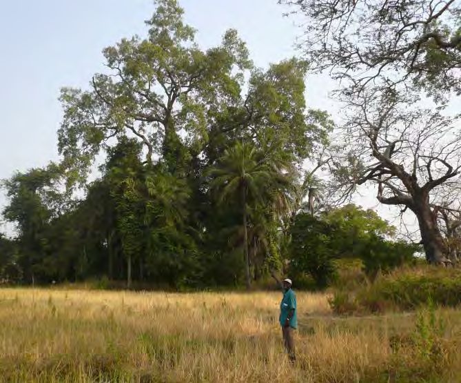
“Land is the foundation of the lives and cultures of Indigenous
peoples all over the world… Without access to and respect for their
rights over their lands, territories and natural resources, the survival
of Indigenous peoples’ particular distinct cultures is threatened.”

                                  Permanent Forum on Indigenous Issues
                                             Report on the Sixth Session
                                                          25 May 2007

Authored by: Dieng Ndiawar and Ndiaye Soulèye
Published by: Natural Justice in Bangalore and Kalpavriksh in Pune and Delhi
Date: September 2012
Cover Photo: A centuries-old shell mound at Petit Kassa, Casamance, Senegal.
© Christian Chatelain

                                  Page 2 of 61
TABLE OF CONTENTS

List of acronyms .................................................................................................................... 4
Acknowledgements ............................................................................................................... 7
Summary ............................................................................................................................... 8
1. Country description and context ...................................................................................... 10
   1.1. Key features of Senegal ............................................................................................. 10
   1.2. Brief history of conservation, state- and community-based ...................................... 13
   1.3. Towards local governance ......................................................................................... 15
    1.4. Forests and marine/coastal areas under the control of the State and areas under the
   control of local authorities ............................................................................................... 17
2. Features of ICCAs ............................................................................................................. 19
   2.1. Range, diversity and extent of ICCAs ......................................................................... 19
   2.2. Key ecological, cultural, socio-economic and political values of ICCAs ....................... 23
   2.3. Main threats to ICCAs ............................................................................................... 24
3. Governance and management of ICCAs ........................................................................... 25
   3.1. How are ICCAs governed and managed? ................................................................... 25
            (i) ICCAs formally established by a resolution of the Regional Council or the Rural
      Municipality and governed directly by the relevant community or Municipality .......... 25
      (ii) ICCAs with no legal backing, such as sacred natural sites ........................................ 28
         (iii) The case of Communal Natural Reserves strongly influenced by the presence of a
      nationally-appointed Conservateur.............................................................................. 28
4. Recognition and support to ICCAs .................................................................................... 29
   4.1. Government recognition and support to ICCAs ......................................................... 29
   4.2. Civil Society recognition and support to ICCAs .......................................................... 31
   4.3. Key issues for the recognition and support to ICCAs ................................................. 32
5. The future........................................................................................................................ 33
    5.1. Future activities planned by the communities, the government, and the civil society ;
   especially in relation to issues of recognition and support ............................................... 33
   5.2 Recommendations ..................................................................................................... 34
      (i) What forms of recognition and support? ................................................................. 35
      (ii) Who should do what? ............................................................................................. 36
References .......................................................................................................................... 37
Annex 1: List of Senegalese RNCs & ICCAs ........................................................................... 38
Annex 2: Sacred sites in Casamance .................................................................................... 41
Annex 3: The ‘mothers of nature’ of KËR CUPAAM .............................................................. 43
Annex 4: Deliberation Act for the creation of the Dindefello RNC ........................................ 45
Annex 5: Case study: Dindefello RNC ................................................................................... 46
(in French) ........................................................................................................................... 46
Annex 6: Creation Act of the Teunguène ICCA ..................................................................... 50
Annex 7: Area of the Three Marigots (patrimony of the Saint Louis region) ......................... 53
Annex 8: RNCs maps ............................................................................................................ 57

                                                           Page 3 of 61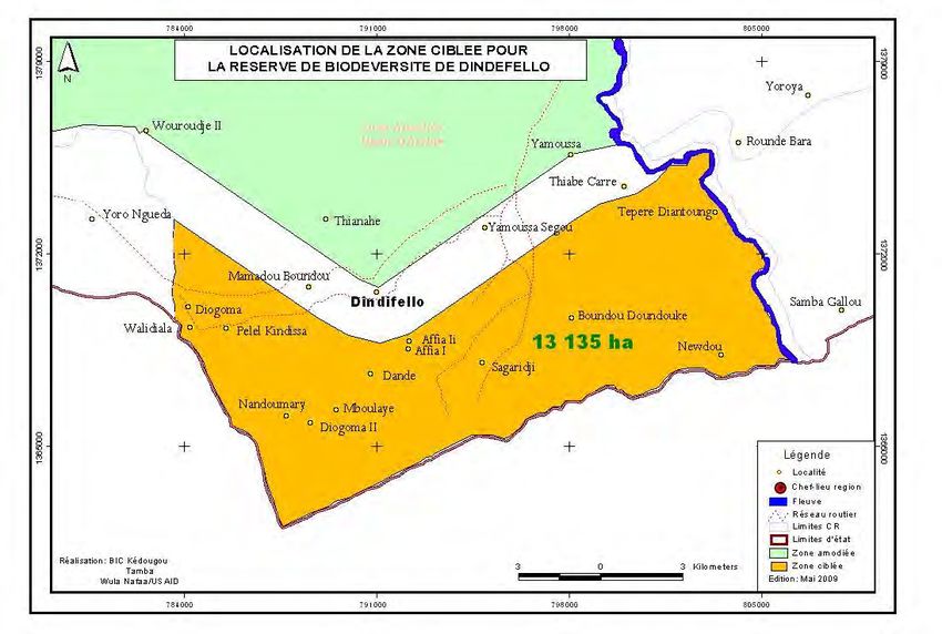
List of acronyms

Acronyms                   French signification            English signification
AFD    –           Agence         Française     de    French Development Agency
FFEM               Développement – Fonds Français     –     Global     Environment
                   pour l’Environnement Mondial       French Facility
ANCAR              Agence Nationale du Conseil        National Agency for the
                   Agricole et Rural                  Agriculture      and      Rural
                                                      Council
ANSD               Agence      Nationale     de  la   National       Agency       for
                   Statistique et de la Démographie   Statistics and Demography
                   au Sénégal                         in Senegal
APCRM              Association des Pêcheurs de la     Fishermen Association of
                   Communauté          Rurale   de    Mangagoulack              Rural
                   Mangagoulack                       Community
CENESTA            /                                  Centre     for     Sustainable
                                                      Development (Iran)
CITES              /                                  Convention on International
                                                      Trade in Endangered Species
CSE                Centre de Suivi Ecologique         Centre      for      Ecological
                                                      Monitoring
CVGD               Comité Villageois de Gestion et    Village    Committee        for
                   de Développement                   Management                 and
                                                      Development
DEFCCS             Direction des Eaux et Forêts, de   Department        of    Water,
                   la Chasse et de la Conservation    Forest, Hunting and Soil
                   des Sols                           Preservation
DPN                Direction de la Protection de la   Department for Nature
                   Nature                             Protection
DRSP               Document de Stratégie de           Poverty Reduction Strategy
                   Réduction de la Pauvreté           Document
EDF                /                                  European         Development
                                                      Fund
FIBA               Fondation Internationale     du    International Foundation for
                   Banc d’Arguin                      the Banc d’Arguin
ICCA               /                                  Indigenous Peoples’ and
                                                      Community
                                                      Conserved Territories and
                                                      Areas
IUCN               /                                  International Union for
                                                      Conservation of Nature
NGO                /                                  Non             Governmental
                                                      Organization
PGIES              Projet de Gestion Intégrée des     Integrated Management of
                   Ecosystèmes                        Ecosystems Project
PNAE               Plan National d'Actions pour       National Action Plan for the
                   l'Environnement                    Environment

                                     Page 4 of 61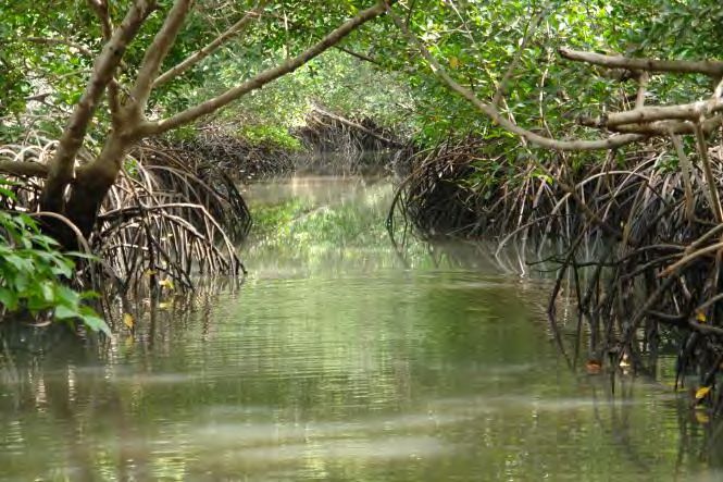
PRODAM    Projet     de    Développement       Agricultural Development of
          Agricole de Matam                    Matam Project
PROGEDE   Programme de Gestion Durable         Sustainable Management of
          des Energies Traditionnelles et de   Conventional           and
          Substitution                         Substitution         Energy
                                               Programme
RNC       Réserve                 Naturelle    Communal Natural Reserve
          Communautaire
SNAPS     Système National des Aires           National       System      of
          Protégées                            Protected Areas
SRB       Société de Réserve de Bandia         Bandia Reserve Company
UNCED     /                                    United Nations Conference
                                               on      Environment      and
                                               Development
UNDP-     /                                    United               Nations
GEF                                            Development Program –
                                               Global Environment Fund
UNESCO    /                                    United Nations Educational,
                                               Scientific    and    Cultural
                                               Organization
USAID     /                                    United State Agency for
                                               International Development
Wula      Projet de Gestion des Ressources     USAID        Project      for
Nafaa     Naturelles de l’USAID au Sénégal     Sustainable Management of
                                               Natural      Resources     in
                                               Senegal

                             Page 5 of 61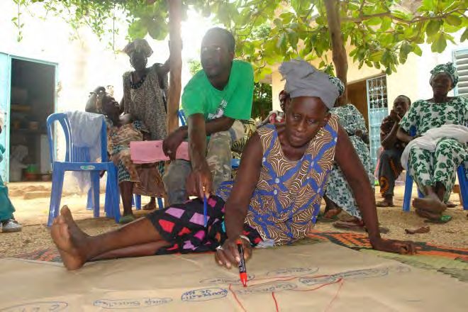
INTRODUCTION
Across the world, areas with high or important biodiversity are often located within
Indigenous peoples’ and local communities’ conserved territories and areas (ICCAs).
Traditional and contemporary systems of stewardship embedded within cultural practices
enable the conservation, restoration and connectivity of ecosystems, habitats, and specific
species in accordance with indigenous and local worldviews. In spite of the benefits ICCAs
have for maintaining the integrity of ecosystems, cultures and human wellbeing, they are
under increasing threat. These threats are compounded because very few states adequately
and appropriately value, support or recognize ICCAs and the crucial contribution of
Indigenous peoples and local communities to their stewardship, governance and
maintenance.
In this context, the ICCA Consortium conducted two studies from 2011-2012. The first (the
Legal Review) analyses the interaction between ICCAs and international and national laws,
judgements, and institutional frameworks. The second (the Recognition Study) considers
various legal, administrative, social, and other ways of recognizing and supporting ICCAs.
Both also explored the ways in which Indigenous peoples and local communities are working
within international and national legal frameworks to secure their rights and maintain the
resilience of their ICCAs. The box below sets out the full body of work.
1. Legal Review
An analysis of international law and jurisprudence relevant to ICCAs
Regional overviews and 15 country level reports:
o Africa: Kenya, Namibia and Senegal
o Americas: Bolivia, Canada, Chile, Panama, and Suriname
o Asia: India, Iran, Malaysia, the Philippines, and Taiwan
o Pacific: Australia and Fiji
2. Recognition Study
An analysis of the legal and non-legal forms of recognizing and supporting ICCAs
19 country level reports:
o Africa: Kenya, Namibia and Senegal
o Americas: Bolivia, Canada, Chile, Costa Rica, Panama, and Suriname
o Asia: India, Iran, the Philippines, and Russia
o Europe: Croatia, Italy, Spain, and United Kingdom (England)
o Pacific: Australia and Fiji
The Legal Review and Recognition Study, including research methodology, international
analysis, and regional and country reports, are available at: www.iccaconsortium.org.
This report is part of the legal review, adapted from the recognition study, 1 and focuses on
Senegal. It is authored by Dieng Ndiawar2 & Ndiaye Soulèye.3
1
Dieng, N. and S. Ndiaye. 2012. Recognition and Support of ICCAs in Senegal. In: Kothari, A. with C. Corrigan, H.
Jonas, A. Neumann, and H. Shrumm (eds). Recognising and Supporting Territories and Areas Conserved By
Indigenous Peoples And Local Communities: Global Overview and National Case Studies. Secretariat of the
Page 6 of 61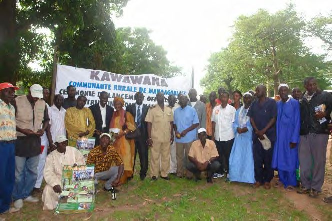
ACKNOWLEDGEMENTS

We would like to thank our families for their support through this work; our colleagues at
the DEFCS and DPN for the relevant documents they provided as well as for their
contributions; our friend Grazia Borrini-Feyerabend for her advice and patience; Christian
Chatelain for his precious contribution; and the translators when we know how difficult it is
to translate some ideas in another language. Ashish Kothari and Aurélie Neumann gave
editorial inputs.

Convention on Biological Diversity, ICCA Consortium, Kalpavriksh, and Natural Justice, Montreal, Canada.
Technical Series no. 64.
2
  Ndiawar DIENG is a Senegalese forest engineer born on February 19, 1949 in Méckhé (Senegal).
After a superior technician curriculum and a specialisation on fauna at the Fauna School of Garoua
(Cameroun) in 1973, he graduated from the Agronomy Faculty of Louvain-La-Neuve (Belgium) in
1983. He later graduated from the Panafrican Institute for Development (Regional Planning and
Land-Use) of Ouagadougou (Burkina Faso). Ndiawar Dieng held a number of positions in the
Senegalese administration, including Director of Water and Forests and Technical Adviser to the
Ministry in charge of Water and Forests. He actively contributed to the redaction of papers on
natural resources, environment and decentralisation. Taking part to the Rio (1992) and Johannesburg
(2002) Summits, he was an actor engaged in negotiations on biodiversity, desertification and climate
change until 2011. He is married and the father of 4 children. Contact: ndiawar_dg@yahoo.fr
3
  Soulèye NDIAYE is a 55 years old Senegalese officer. He has a 32-year professional experience in the
field of nature conservation, for his country and various NGOs. He holds a master in Geography from
the University of Dakar (1980), a diploma as wild fauna specialist (superior curriculum) from the
Fauna School of Garoua (Cameroun), and a master in Forestry Sciences from the University of Laval
(Quebec, Canada). He occupied several positions in the Senegalese administration, amongst which:
Conservateur of the Niokolo-Koba National Park, Assistant to the Director of National Parks, Director
of National Parks, Ministry Inspector, and Technical Adviser to the Minister of Environment. His
university and technical background on the one hand, and his field expertise on the other hand,
make him highly qualified on the following topics: biodiversity and protected areas management,
forestry, transboundary biosphere reserves, ecotourism and protected areas tourism planning, rural
economy and regional development, community, state and private fauna reserves creation, wildlife
transfer for repopulation of protected areas, chimpanzee populations monitoring, environmental
impact assessment for endangered fauna species and protected areas. After leaving it in 2000,
Soulèye Ndiaye is currently back to his position of Director of National Parks and Reserves of Senegal.
Contact: soulendiaye@gmail.com

                                             Page 7 of 61
SUMMARY
Sustainable management of natural resources is crucial in Africa where – short of the
lifestyle of ‘developed societies’ – local people kept a watchful eye on the resources on
which they directly depend for their livelihoods. In Senegal, local people established through
time rules for the management of natural resources that were generally respected by all.
Transgressions of these rules could even be punished by death in view of the crucial
importance of natural resources as sources of goods and services, and their role in local
beliefs systems (sites for worship, etc.).
Both a modern signalization and a fetish secure the ICCA of Kawawana in Casamance
© Christian Chatelain, 2010
The convergence of local concerns with economic and environmental considerations
facilitated the adoption of a colonial Decree on 4th July 1935, which set the Forest
Management Plan in French-speaking Africa. In this way, the State created its conservation
services and most protected areas. Post-independence (1960), however, management has
not always resulted in conservation of natural resources. The rural population got
progressively separated from traditional practices and natural resources, which led to
frustration, while illegal activities gained ground over the years. The National Propriety Law
No. 64-46, dated 17 June 1964, and its implementing regulations (Decree No. 64-573 dated
30 July 1964 and Decree No. 72-1288 dated 27 October 1972) actually caused a revolution in
the rural areas by removing landowners and transferring the land to its real users. Natural
resources were, at the same time, nationalised.
It was not until 1996 that the Government decided to apply the following two texts, as part
of the deepening of the Decentralisation Policy:
Law 96-06 dated 22 March 1996 – i.e. the Local Government Code – which created,
among others, three types of local authorities (Region, Municipality, Rural
Municipality) on the principle of free administration; and
Law 96-07 dated 22 March 1996 – dealing with the transfer (decentralisation) of
authority regarding Environment and Natural Resources (implementing decree No.
1134 dated 27 December 1996).
Page 8 of 61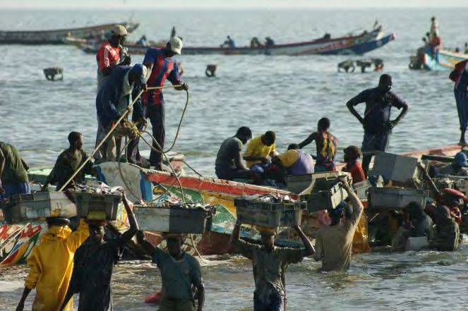
The evolution of governance from systems favouring repression to participatory and co-
management systems has even reached today the situation of direct governance by entities
other than the State, in particular for the case of local communities such as the Bassari
indigenous people in the southeast of Senegal, and for the case of local authorities. Secular
mechanisms guided by ancient customs have evolved into formal procedures established by
the villagers and sanctioned by a ruling of the Rural Municipality and to the establishment of
ICCAs recognised by the State representatives.

Along with the possibility of establishing ICCAs (which was legalised by the texts of the Third
Phase of Decentralisation), people have set up mechanisms to give responsibilities,
individually or collectively, to different groups (the young, the old, women, professional
associations). Despite this vision, however, there are still gaps in the recognition of ICCAs in
the national system of protected areas. For instance, areas in the maritime domain – where
thousands of people need to find the source of their livelihood – are still excluded from the
possibility of being declared ICCAs, as they are excluded from the decentralisation legislation
that transferred resource management authority to Regions, Municipalities and Rural
Municipalities. Change may just be forthcoming however, as the success of some on-going
pilot experience may influence a positive policy evolution.

In the experience of the authors, traditional patterns of conservation of biological resources
are very efficient, especially with the system of sacred sites, where all community members
respect the local conservation rules. This study, however, was not designed to offer a
systematic demonstration of such effectiveness, which might be the subject of other
analyses.

We believe it is time to recognise the vital role of ICCAs in the effective conservation of
natural resources and of local communities in the governance of protected areas. The future
of biodiversity conservation and natural resources in Senegal is intimately linked to such
recognitions. The decision to create ICCAs by local communities in their local area should
suffer neither legal nor regulatory obstacle. The legal value of community decisions for
conservation should not be questioned, even in the case of ICCAs created to serve as places
of worship or reserved for cultural activities.

                                         Page 9 of 61
1.        COUNTRY DESCRIPTION AND CONTEXT

1.1.      Key features of Senegal

Covering an area of 196,720 km² of which 75% is located at an altitude of less than 50
meters, Senegal is a Sahelian country bordered to the north by Mauritania, to the east by
Mali, to the south by Guinea and Guinea Bissau, to the west by the Atlantic Ocean and
Gambia sticking in its Atlantic Coast like a pin (see Map 1).

                              Map 1: Location of Senegal in West Africa

Its population of about 12 million (12,171,265 – ANSD, 2009) is relatively young, with 40%
under 20 years of age. It consists of about twenty ethnic groups with the Wolof represented
in all regions accounting for almost 40% of the population. The annual growth rate of the
population is of 2.34% and nearly a quarter live in the city of Dakar. The average population
density is of 61.21 persons per square kilometres. However, there is a large difference in
population density between Dakar and the rest of the country.

State administrative units: there are in Senegal 14 administrative regions (Dakar, Diourbel,
Fatick, Kaffrine, Kaolack, Kédougou, Kolda, Luga, Matam, Saint Louis, Sédhiou,
Tambacounda, Ziguinchor and Thies). The regions are divided into departments (often 3 per
region) including an average three districts each. The village completes these administrative
units. All administrative units are led by a designated representative of the State.

Local authorities: besides these administrative units – and only sometimes overlapping 4 –
there are the Collectivités Locales: the organs elected by the local residents, such as the
Region, the (Urban) Municipality (in French Commune) and the Rural Municipality (in French
Communauté Rurale), with no relationship of subordination to the state administrative units
noted before. The Collectivités Locales are run by local elected officials gathered in Councils.
Each Council is led by a Board coordinated by a President. In average, we find three Rural
Municipalities in a district. In some large cities, we find several urban municipalities.

4
    In Senegal, only the administrative region needs to correspond spatially to the Regional Council.

                                              Page 10 of 61
Senegal has a Sudano-Sahelian semi-arid tropical climate with one rainy season extending
from July to October. Rainfall has decreased significantly in recent decades and has great
spatial and temporal variability. It has decreased sharply in the past 40 years and actually it
rains less than 300mm a year in the north and about 1000 mms a year in the south. In the
same time, the rainfall has exhibited a swing of 100 to 200mm isohyets southwards from the
normal range of 1931-1960.
Because of its geographical position, the country is exposed to a very particular wind regime
modifying some climate parameters. Compared to the same latitude in the African
continent, the decrease in rainfall is sharper traveling from South to North, but the
saturation deficit and the maximum temperature during the dry season are lower, especially
near the coast.
These characteristics significantly influence the wildlife species in the forests between
northern latitudes 12° 30' and 16° 30' in the Guinean, Sudanese and Sahelian territories, all
characterised by a marked species endemism (Gueye 2000).
Protected areas in northern Senegal host large and diverse colonies of migratory birds (here
in Djoudj National Park).
© Grazia Borrini- Feyerabend, 2011
The Senegalese territory contains significant animal, plant and water resources (CSE 2002).
However, the country has limited quality land resources. Against the five categories of
existing soils, we find that almost half are poor or unsuitable for agriculture (47%), the
percentage of poor soils is 36% (Gueye 2003).
Agriculture remains one of the most important sectors of economic activity. According to
the Poverty Reduction Strategy Document of Senegal (DSRP – Document de Stratégie de
Réduction de la Pauvreté) of the Ministry of Economy and Finances (MEF 2002), agriculture
occupies more than half of the population, contributes 10% to gross domestic production
and accounts for an average of about 10% of the public investment programme. The
agricultural sector also plays a major role in the economy through its contribution to food
security, by providing raw materials for agro-industry (e.g. groundnuts, cotton), by absorbing
Page 11 of 61a portion of industrial, semi-industrial and handicraft production (e.g. fertilisers, pesticides,
agricultural equipment).
The majority of the poor live in rural areas and derive their livelihood mostly from
agriculture and natural resources, which, for decades, have continued to deteriorate due to
harsh weather conditions (drought) and pressure from human activities (poor agricultural
practices, deforestation, overgrazing, misuse of pesticides, etc.).
This situation exacerbates the competition for these resources and land disputes, two
factors that can be considered as causes of loss of biodiversity and latent desertification, but
which were masked in the past by traditional practices promoting conservation.
Fishery resources (here at Joal-Fadiouth) have attracted many impoverished rural people
over the past 20 years.
© Pablo Chavanche, 2010
This has plunged the agricultural sector in a very deep crisis, especially since the mid-80s,
because of the following:
Decrease in rainfall;
Steady decline in producer prices and the adoption of techniques with a low use of
financial capital (e.g. fertilizers), but high use of land capital, due to a strong pressure
on resources;
Decline in yields and production, impoverishment and growing debt of the rural
population; and,
Land issue, in particular, access to land, tenure clarity and food security.
The National Seminar on Desertification (SEMINADES), organised in 1985 in Saint Louis was
defined on the basis of local constraints and potential eco-geographical zones. There are six
relatively homogeneous zones when taking into account the diversity of soils and their
potential for agricultural use, combined with the climatic diversity and availability of water
resources, they are as follows (see Map 2):
The area of the Senegal River Valley, which covers the far north and east;
Page 12 of 61 The Silvopastoral zone located just south of the Senegal Valley and occupying part of
the Sudano-Sahelian zone;
The Niayes located to the west, along the northern coast;
The area of the Groundnut Basin that occupies the centre and western centre of the
country;
Casamance in the south of the country where rainfall exceeds 800 mm;
The area of Eastern Centre and the south-east of the country (Eastern Senegal).
Map 2: Eco-geographical zones of Senegal
(Source: http://www.cse.sn/annuaire/ressnat/forestieres/cartezoneseco.htm)
The land is becoming less and less suitable for agricultural use and the National
Environmental Action Plan (PNAE 1997:38) also considers the reduced fertility as one of the
major environmental problems.
Forests that were the last resort in times of scarcity have been heavily over-used. They have
thus become less dense, less diverse and less productive.
Everyone is quick to agree that natural resources must be better used, outside but even
within protected areas.
1.2 Brief history of conservation, state- and community-based
The issue of sustainable management of natural resources is as old as the world. It is crucial
in Africa where, in the absence of ‘real’ development that would have provided accessible
products from biogenetic resources, local people have kept a watchful eye on these
resources.
Examining the history of Senegal, we find out that local people have always established rules
respected by all and transgressions could be punished by the death penalty, as was the case
in the realms of Baol and Cayor for the cutting down of a Kadd tree (Acacia albida).
Page 13 of 61In addition to being a source of goods and services, the forest was also a central cultural
element. One example is the importance of the sacred groves of Casamance for ceremonies
such as the Boukout (or Futampaf) – male and female initiation to social life known since the
12th century.
This concern along with economic and environmental considerations facilitated the adoption
of the July 4th 1935 Decree, setting up a Forest Plan in French-speaking Africa through which
the State conservation services and most protected areas were created.
Since this Decree, the main response was to register, under various objectives and statutes,
the maximum possible number of protected areas (to the benefit of the State) and to
establish mechanism to repress violations of their rules.
The registering consists in the creation and enforcement by the State of a set of restrictive
rules and regulations on the use of a forest whose influence is well defined. From an
economic and environmental perspective, the goal was to limit human pressure on forests
to the minimum use of the population.
Thus forests have been registered for the supply of fuel trains on the Dakar-Bamako, sylvo-
pastoral reserves (especially in the Ferlo Region) for farming, the perimeters of restoration
to counter wind erosion on the main coast, the Niokolo Koba National Park for the
conservation of wildlife, the gonakié (Acacia nilotica) forests to protect the banks of the
Senegal River and produce wood for boats, forests timber, and so on.
Procedures of gazetting (and de-gazetting) are defined in the Forest Law and supplemented,
if necessary, in the Law of Hunting and are the subject, in the final stage, of a decree signed
by the President of the Republic.
Page 14 of 61Map 3: Map of land use in Senegal
Boundaries of protected areas indicated in green (Source: CSE 2003)
The gazetting procedures from before the Independence of the country (1960) have also
evolved and been adapted to the current realities, with the help of the impact of other
relevant texts in the management of natural resources. For example, the Forest Law had
been revised in 1993 (Act No. 93-06 dated 4 February 1993 and Decree No. 95-357 dated 11
April 1995) to adapt to Rural Forestry Development Policies (Participatory Agroforestry) and
benefit-sharing and involvement of the population around the boundaries of parks in their
management.
Thus, the initial situation saw the State considering natural resources as its exclusive
property, which ‘no one else should touch’. Punishments related to that included fines and
even humiliating imprisonment sentences. The government paid people to carry out specific
jobs to manage the ecosystems.
Subsequently, the first bridge was to create so-called community activities. All power still
belonged to the state but the local people were asked to work gratuitously, or for the
payment of subsidies (food, wells, shops, millet mills, fence material, etc.)
Then came the social/rural forestry approach, which assigned, but not on legal grounds,
management responsibilities (under state supervision) to people from specific villages,
groups of villages, or regions.
The legal issues have been solved with the texts of the Regionalization (see following
section), which established a transfer of legal authority (Government of Senegal, 1996).
Since then, and although confusion still exist on the side of some state officials and the side
of some local politicians, people began to understand that they were working for themselves
and to decide what they considered best for them.
1.3 Towards local governance
Nowadays, after a long evolution, the situation constitutes a deliberate duality created to
promote conservation with on the one hand communal and private forests and on the other
the forests of the State.
This is drawn from the texts of Decentralisation with the Law 64-46 dated 17 June 1964 on
the National Territories which is inspired by traditional Black African collective
ownership/tenure system which acknowledges individuals’ mere use rights over the land. It
allows the State ownership rights over the land of the National Domain to ensure their
Page 15 of 61‘rational’ use and development, in conformity with development plans and programmes
(programmes d’aménagement). The lands are then classified into four categories: urban
areas, gazetted/registered areas (domaine classé), areas of land allocated to Rural
Municipalities for their own development (terroirs), and pilot areas (for large projects and
programmes).
In this process of decentralisation – which strongly influences land management – Senegal
has opted for several elements of an irreversible policy. This includes:
• Law No. 72-25 dated 25 April 1972, which creates a new administrative level: the Rural
Municipality;
• Law No. 90-37 dated 8 October 1990, which relieves the Deputy Prefects of their power
of management over the Rural Municipalities, appointing the President of the Rural
Council instead, and eliminates the Office of Municipal Administrator to the benefit of
Mayors;
• Law 94-55 dated 13 June 1994, which formalises the free administration by local
authorities;
• Laws 96-06 and 97-07 dated 22 March 1996, which includes a Local Government Code
and Transfer of Powers to local authorities (Region, Municipality, Rural Municipality) as
part of the deepening of the Decentralisation Policy. These aim to establish the general
principle of free deliberations and local management by decentralised authorities and
an appropriate judicial review of their work.
Decentralisation: speech and governance back to the local communities. Here, women of the
Popenguine Natural Reserve.
© Christian Chatelain, 2010
From 1997 on, all relevant legal texts were to be adapted to the pre-eminence of the texts
just mentioned above, called the Third phase of the Decentralisation or “Regionalisation”.
By 1996, the State had also adopted a Land Action Plan, a background paper for a reform of
the Law on the National Domain (LND). According to this Plan, in order to end the status
quo, land privatisation could be allowed to take place and thus encourage the emergence of
economic actors, whether resident or not, and independent of local institutions.
Page 16 of 61But the Plan runs the risk of also encouraging all kinds of conflicts, between individuals and
communities, communities and authorities, or between communities themselves.
1.4 Forests and marine/coastal areas under the control of the State and areas under
the control of local authorities
Senegal’s forest cover comprises a Registered Domain (Domaine Classé), which is
constituted by all the registered protected areas under the jurisdiction of the Directorate of
Water and Forests and the National Park Service. This registered domain covers about 35.7%
of the country.
The 234 state protected areas cover a total area of 7,135,617 ha (3,62 % of the national
territory), including 209 Forests, 10 Reserves, 8 Parks and 7 Game areas. We need to stress
that even at the level of technical services, the figures shown in table 1 are somehow
imprecise (some bring the total to 210 only) and different terminologies are used by
different agencies. These inaccuracies are a sign of inadequate monitoring of protected
areas managed by the State and of the existing problems of maintaining statistics faced by
those services.
Table 1: Overview of state terrestrial protected areas by type
Category Types of protected areas No. Surface Observations
of Areas (ha)
Forests Registered Forest (Forêt Classée) 183 2510155 No exploitation
Sylvopastoral Reserve (Réserve 17 914580 Grazing area
Sylvopastorale considérée comme forêts) protection
Managed Forest (Forêt Aménagée) 9 9080 Organised
exploitation
Reserves Botanical Reserve (Réserve Botanique) 1 16 Full protection
Biosphere Reserve (Réserve de Biosphère) 1 752 A mix of full
protection in the
core areas and
sustainable
production areas
in their
surroundings
Integral Natural Reserve (Réserve Naturelle 1 3 Full protection
Intégrale)
Wildlife Reserve (Réserve de Faune) 7 1395536 Wildlife
protection
Parks National Park (Parc National) 7 860300 Full protection
Zoological Park (Parc Zoologique) 1 80 Agreement for
management
Game Hunting Area (Zone d'Interêt Cynégétique) 7 1445115 Organized
hunting
TOTAL 234 7135617
Page 17 of 61Source: Bureau d’Aménagement et de Cartographie (BAC), Directorate of Water and Forests,
2005.
The boundaries of most registered forests and reserves are regularly encroached upon and
these protected areas are sometimes illegally occupied. This is due to the inadequacy of the
monitoring, to illegal operations and to clearing the forests. These factors, combined with
climatic deterioration, have led to severe degradation of some forests.
There are also 5 Marine Protected Areas created under the impetus of the department in
charge of conservation (DPN). Their total area is 103,000 ha and they include Kayar (17,100
ha), Saint-Louis (49,600 ha), Joal (17,400 ha), Abéné (11,900 ha) and Bamboung (7,000 ha).
Two Marine Community Reserves were also created by the decree n° 2004-1408 of 4
November 2004, Somone and Palmarin, adding up to 11,150 ha.
The MPA of Bamboung developed ecotourism activities in order to reach self-financing.
© Christian Chatelain, 2010
Since the texts of the third phase of Decentralisation (Regionalisation), adopted in 1996,
locally elected authorities – Region, (Urban) Municipality, Rural Municipality – have the
opportunity, in the territories under their jurisdiction, to create their own protected areas.
Under this new possibility, in addition to the areas protected by the state, we saw the
creation of some 33 Communal Natural Reserves (Reserves Naturelles Communautaires –
RNCs)5. Some RNCs are ‘Community Heritage Areas’ (Aires du Patrimoine Autochtone et
Communautaire – APACs) existing in customary law from long before the approval of the
legal text on the Decentralization.
These protected areas formally created by Rural Municipalities (i.e. the Communal Natural
Reserves, including the pre-existing community heritage areas) cover an area of
approximately 758,880.42 hectares. They are listed in Table 1 and Table 2 in Annex 1.
5
Please note that despite the similarity in name the governance of RNCs differ from that of the
Marine Community Reserves mentioned above.
Page 18 of 612. FEATURES OF ICCAS
At the 5th World Congress on National Parks held in Durban, South Africa, in September
2003, it was recognised that “an important part of terrestrial biodiversity is found in
territories belonging to indigenous and local communities (including mobile) or in territories
controlled or managed by them.”
It was also recognised that these sites called ‘community conserved areas’ are extremely
diverse in terms of their institutions of governance, management objectives, their ecological
and cultural impacts, and other characteristics.
In Senegal, as in some other countries, most of the areas conserved by communities are not
recognised in the national and international conservation system and are largely set outside
of the official protected area networks of different countries.
2.1 Range, diversity and extent of ICCAs
Senegal’s history teaches us that local people have always set natural resource management
rules respected by all because nature provided all necessary goods and services, and forests
had, in addition, major cultural values. There were sacred groves, sites reserved for spiritual
retreats, land reserves or protected reserves that were not supported by the legal texts
referring to conservation and to which technical bureaus paid little attention.
Nevertheless, the good state of conservation often present in such areas attracted the
attention of the technical bodies in charge of conservation (because of their added
conservation value) and this led to:
Establishment of Marine Community Reserves by the Direction of National Parks ;
6
Revision of the Forestry Code of 1993 that grants more rights and responsibilities to
local communities.
However, although the texts of Decentralisation back the legal existence of Communal
Natural Reserves (Réserves Naturelles Communautaires – RNCs) – which is a label that can
be offered to ICCAs to officially recognise them – many agents of technical conservation
bodies do not yet have a clear knowledge of their existence and do not consider them as
part of protected areas. Thus, it is not uncommon to hear that the RNCs are not part of the
national network of protected areas.
The establishment of areas conserved with or by the communities meets the following
objectives:
For Communal Natural Reserves (RNCs) the creation objectives are based on the
conservation of biodiversity but also include supporting and improving the lifestyles of
6
These are Somone and Palmarin, established by deliberation of the Rural Council but under shared
governance with the Direction of National Parks, with a Conservateur nominated by that Direction by
request of the Rural Municipality.
Page 19 of 61people. These objectives are also common to the Marine Community Reserves co-
managed with the technical organs of the State (Somone and Palmarin).
Some RNCs have been created and are managed by Rural Municipalities, but with the
active support of projects and programmes that have been funded by development
(and conservation) partners – following also their specific objectives.
Sacred natural sites and other sites created and managed by local communities not
formally recognised by the State are generally motivated by cultural and/ or worship
considerations.
In general Communal Natural Reserves – as other special entities such as the Pastoral Units –
have several objectives and a wider sense of purpose in the life of rural communities than
purely conservation-oriented ‘protected areas’.
Areas of worship as sacred groves appear, because of their rules that strictly exclude
development destinations, to deviate slightly from the definition mentioned above, but they
do respond deeply to the patrimonial destination.
Some of these ICCAs may only have local impact and value, including for the conservation of
local resources. Others, however, also have national conservation value. An example is the
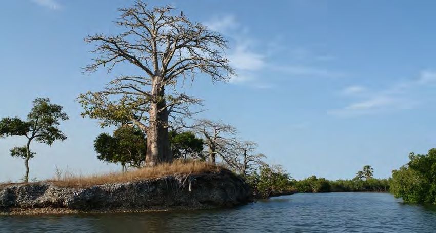
Communal Natural Reserve of Dindefello, harbouring the only waterfall of national interest
in the country.
Manatee (Trichechus manatus) is among the most protected species in Senegal. The MPA
Pointe Saint Georges in Casamance, looking for recognition as an ICCA, hosts manatees.
© Gerard Soury.net
While we know that Communal Natural Reserves cover an area of almost 759,000 ha, it is
difficult to estimate the area covered by sacred sites and other not yet recognised
community heritage areas. The size of the latter varies greatly from one region to another.
We must also recognise that the importance of the site cannot be measured in terms of area
but of the importance given to it in the community beliefs, cultural practices or worship and
of the effectiveness of their management.
Page 20 of 61Formerly, there were in many parts of Senegal small kingdoms created on ethnic grounds
with a formal hierarchical division around a King (including vice-kings, councils of elders,
spiritual guides responsible for mystical matters, individuals responsible for the
management of land, forests and water, etc.). Today most of these kingdoms have
disappeared but those remaining (Casamance, Dakar, etc.) are still trying to perpetuate the
traditions, including for the management of natural resources.
The King of Oussouye (Casamance) attempts to preserve the traditional rules for natural
resources conservation.
© Christian Chatelain, 2008
In the three departments of Casamance Region alone, it is reported that there are 81 sacred
sites (Government of Senegal and IUCN, 2005). The distribution of sacred sites is very
uneven between departments. The following table issued from the Census for purposes of
developing a strategy for managing protected areas of Senegal (the list can be non-
exhaustive, see table in Annex 2) shows the distribution of these sacred sites by department
in Casamance alone.
Table 2: Sacred natural sites in Casamance
Department Number of identified Sacred Sites Surface of the sites
Ziguinchor 4 Approximately 1 ha
Bignona According to government sources 15 in total; 4 to 20 ha
according to local sources 42 only in the Rural
municipality of Mangagoulack7, which is only one of
the municipalities of Bignona.
7
The number for Mangagoulack is provided by Salatou Sambou, from the Rural Municipality of
Mangangoulack.
Page 21 of 61Oussouye 62 1 to 13 ha
Tentative observations on the above table concern the diversity of these sacred sites
registered in the category of ICCAs:
The very high number of sacred sites in the department of Oussouye is due to the
great ethnic diversity of the people on the one hand and to the ancestral practices of
worship other than religions such as Islam and Christianity;
The area of Oussouye has more forests than the other two departments;
Several ancestral territories are conserved in the department of Oussouye.
The objectives of establishing a site as sacred include:
Sacred forest for the circumcision and initiation of young people (boys or girls) of the
villages around the sacred site;
Residence of the king (mainly for sacred sites in the Department Oussouye);
Place with fetishes for men or women of the community;
Place of prayer for the community;
Cemetery for a particular category of the population;
Sites exclusively reserved for women (indicating that gender aspects are taken into
account in the establishment and operation of several sacred sites).
This sacred grove of Casamance is well known and highly protected by all the neighboring
community.
© Grazia Borrini-Feyerabend, 2008
Page 22 of 61In these sacred sites, all exploitation of biological resources is strictly prohibited. 8 In several
of these sites, entry and passage are strictly regulated. Only the insiders or the conservation
guards or the guardians of the tradition are authorised to enter or remain in them. Such
sacred sites are also present in other regions, particularly Fatick (Kharwak, Back, and Laga in
Foundiougne), Kaolack, Kolda, Tamba, Kédougou and Diourbel. Their creation and
administration are no different from those found in Casamance. Differences are only in their
numbers.
In other parts of the country, there are no kingdoms as in Casamance9. Sacred sites are
located near the ethnic group like the Sérère in central and western Senegal, in the
administrative Regions of Fatick, Thiès and Diourbel. In Tambacounda and Kédougou, where
there are ethnic minorities such as the Bassari, the Cogniaguis, the Tenda, the Diallonkés and
the Bédiks, sacred sites are still maintained for cultural or religious activities.
A census of the sacred sites is still to be made. A base is in place for the setting up of a
database in order to develop a strategy for managing the protected areas of Senegal.
2.2 Key ecological, cultural, socio-economic and political values of ICCAs
While no study yet exists regarding the actual biological value of ICCAs in Senegal, their
socio-economic values and policies are defined by their goals of creation and their
management. ICCAs are dedicated to resource valorisation by using natural resources in a
sustainable way. In Senegal, several examples illustrate the socio-economic values of these
areas:
• Use of eco-tourism circuits;
• Sustainable use of fisheries;
• Sustainable use of honey;
• Sustainable use of natural resources in general;
• Sustainable use of rangelands for livestock;
• Conflict-resolution between actors like herders and farmers;
• Creation of employment for the youth;
• Creation of tourist camps in villages;
• Participation in the fight against rural poverty.
8
No study exists on the biological value of these sites, and for the local populations the cultural and
worship values are the most important.
9
Some believe that kingdoms were actually imposed upon the Djola people of Casamance by the
French colonial powers.
Page 23 of 61The Kawawana ICCA (here the sacred bolon of Mitij) is a unique site for the reproduction of
aquatic and terrestrial life.
© Christian Chatelain, 2008
In addition, the very recognition of the existence of these areas by national legislation (by
the local Law on the transfer of powers over environmental and natural resource
management for Regions, Rural Municipalities and Rural Municipalities) can be seen as
having social value in itself.
2.3. Main threats to ICCAs
In Senegal, as in several other countries, the ICCAs in Rural Municipalities are faced with
threats. The relative importance of threats to these areas is difficult to measure because of
the diversity of their creation objectives and of their modes of governance.
Among the threats facing these areas are the following:
The risks, seen from the government, of non-compliance by the local community and
by migrants with the land legislation governing or securing these areas;
The creation of unsustainable development projects, like large-scale tourism activities,
productive activities, etc.;
The interference of the national policy in the governance of the ICCAs for example by
the imposition of a state appointed manager (Conservateur);
Access to resources by people who do not share the same religious or cultural beliefs
(for example at Joal-Fadiouth where Catholics and Muslims live in the same area, share
the same resources but have different livelihoods, different needs and different visions
of what is important to protect);
Loss of legitimacy of the customary rights because of patterns of privatisation or
superimposition of a modern way of life or/and the break of the intergenerational
transmission;
Loss of cultural values and beliefs of the youth due to globalisation.
Page 24 of 613. GOVERNANCE AND MANAGEMENT OF ICCAs
3.1 How are ICCAs governed and managed?
The governance of ICCAs depends on who and how established them. But it is important to
attempt a clarification of terminology and move towards harmonization of designations. We
can identify two main ‘types’ of ICCAs in Senegal, as follows:
(i) ICCAs formally established by a resolution of the Regional Council or the Rural Municipality
and governed directly by the relevant community or Municipality
In this first category one finds the Communal Natural Reserves – RNCs formally recognised
by a decision of the Rural Municipality or of the Regional Council, with governance assigned
to the relevant community or Municipality. These may be established only recently or be
Community Heritage Areas of more ancient origin.
The provisions of Law No. 96-07 dated 22 March 1996 on devolution of authority to Regions,
Municipalities and Rural Municipalities in terms of environment and natural resource
management (in particular Article 30), as well as the provisions of Decree No. 96-1134 dated
27 December 1996 on the implementation of devolution of authority to Regions,
Municipalities and Rural Municipalities in terms of environment and natural resource
management (in particular Articles 2, 48 and 50), give to Rural Municipalities the privilege to
create reserves in their local community. These provisions do not apply to the maritime
public domain that is not affected by devolution of authority, but this may just be
forthcoming (the success of some on-going experiences may influence a positive evolution in
this sense).
From the perspective of governance, there is a ruling by the Rural Municipality that assigns
certain powers to an existing organisation of the concerned populations (Village Committees
and/ or inter-village Development Committees, Environmental Commissions, committees or
associations of fisherfolks, farmers, pastoralists, eco-guards, etc.), establishes good practices
(charte de bonne conduite), some regulations or the equivalent of a Statutes, a collaborative
management plan (plan de gestion concerté), a scientific Council (and/ or a Council of
Elders), etc.
Besides this, stands the inevitable question of monitoring; as outsiders – or even some
members of the community – may be tempted to not respect the rules because of the
profits of illegal exploitation of resources. It is thus needed to have guards, maybe even full-
time employed.
These guards should be compensated. There are examples in Senegal of eco-guards
recruited either by government institutions (DPN, DEFCCS), programs and projects (PGIES,
the Wula Nafaa), local structures (CVGD), or the Rural Municipality itself, for the task of
surveillance. Private companies like the Bandia Reserve Company (SRB) also employ this kind
of staff.
Page 25 of 61The surveillance conducted by the community itself is very effective. Here, the President of
the Kawawana ICCA in Casamance burns prohibited nets.
© Grazia Borrini-Feyerabend, 2011
For instance, at the Niayes RNC, eco-guards were paid from resources from a contract
engaged with the state – a sort of partnership agreement where an entity (a project, the
State or an NGO) provides support to the Rural Municipality in exchange for a voluntary
commitment to manage its natural resources with some agreed specific objectives. In that
case, two eco-guards were paid 40,000 FCFA per month each.
To cope with the actual severity of the problem of surveillance, the Ministry of Environment
and Protection of Nature has also, at one time, considered creating a statute to harmonise
conditions of hiring such personnel, without financial support.
The will to take responsibility for the compensation of these eco-guards (e.g., compensation,
at the CVGD level, included in the allocation of revenues from exploitation of resources)
appears to be temporarily abandoned, probably because of the fact that it could bring
excessive burdens to the State.
We believe that the governance of the Kawawana ICCA in Casamance (Box 1) is a typical
example of community governance.
Box 1: Kawawana ICCA, Casamance
Creation date: March 20, 2010, approved by the Governor of the Region on 1 June 2010.
Location: Region of Ziguinchor, Rural Municipality of Mangagoulack (8 villages, 12,000
inhabitants).
Ecosystems and wildlife: Kawawana is in a tropical estuary embroidered with inlets and
mangroves. It hosts an amazing biodiversity, with many fish (all local species), manatee,
humpback dolphin, crocodile, birds, small mammals, shellfish, mangroves, wild plant species,
Page 26 of 61etc.
Surface: 9,665 ha.
Design: a system of zoning and management rules for conservation: long-term biological rest
(regeneration and protection) and sustainable use of resources (production).
Governance: by bodies created by the local community.
Benefits for local people:
Better fish yield: benefits for the whole community, reducing rural-urban migration,
improved nutrition for families, especially for children.
Local level of commitment, teamwork and organisation with: peace, solidarity,
dialogue, sharing, better knowledge- and capacity-building on the subject of the
environment.
Decision-making bodies: the Council of the Rural Municipality, the APCRM Assembly, the
Office of the APCRM, the Council of Elders, the Scientific Committee, the State
Representatives.
Source: Personal communication from Salatou Sambou, Kawawana ICCA and Mangagoulack
Fishermen Association.
The example of the RNC of Boundou in the Tambacounda Region (Box 2) is also significant.
This RNC was created by 4 Rural Municipalities and the participation of a community interest
group from an Urban Municipality. It is an example of a Multi-Communal Natural Reserve.
Box 2: Cross-Community Natural Reserve of Boundou
Creation date: 2009.
Deliberation of 4 Rural Municipalities: Dougué, Koussan, Sinthiou-Fissa, Toumbourou with
the participation of the Bakel Community Interest Group.
Ecosystems and wildlife: a rich woodland (mainly combretacee, pterocarpus, Terminalia,
bamboo, etc.) subject to violent bush fires due to their extended grass cover where wildlife
lived in great abundance. Biodiversity there was impressive but it has almost disappeared
because of hunting pressure (legal hunting and poaching in managed areas) and land
acquisition pressure (villages, fields and more recently, coal mining). Relict fauna includes
the red striped gazelles (Gazelle rufifrons). In the rainy season, one can also observe the
passage of antelopes leaving the National Park of Niokolo-Koba. Other species encountered
are the monkeys, common jackal and sedentary birds such as guinea fowl, francolin, doves
and parrots.
Surface: 120,000 ha.
Location: Administrative Region of Tambacounda.
Governance: Local Bylaw.
Monitoring: 32 volunteer eco-guards from the local community.
Partners: Regional Council of Tambacounda, General Council of Isère (France), Niokolo-Koba
National Park, Inspectorate (Inspection d’Académie) of the Academy of Tambacounda,
French Committee of the IUCN, Regional Development Agency of Tambacounda, USAID
Programme / Wula Nafaa; French Global Environment Fund, French Development Agency,
National Programme for Local Development.
Source: The Boundou Letter Number 7, January to March 2011 (Newsletter of the
Page 27 of 61Communal Natural Reserve of Boundou).
(ii) ICCAs with no legal backing, such as sacred natural sites
In Senegal, sacred natural sites have no legal backing but are recognised informally and
usually well respected since their inception, because of the will of local communities
combined with some generalised form of ‘cultural respect’ by the staff of governmental
agencies. The creation of sacred sites, often called ‘sacred groves’, is generally motivated by
cultural or worship aspects.
Their mode of governance can fall into one of the two following categories:
Ruled by a family: governance by a family which acts as protector with matriarchal or
patriarchal decision-making. Most often, the family is the very one that established the
sacred site at the very origin.
Ruled by a local informal Council: governance by a council of elders or of initiates,
whose members are chosen by community rules following criteria defined by the
community. Aspects of management of sacred sites are defined by internal rules often
applicable to everyone, even foreigners. Exceptions are often made for guards or for
initiates.
Prohibitions usually enforced in sacred sites include:
Lighting fires;
Cutting timber;
Picking fruit;
Entering the premises; and
Dividing the land for other purposes.
Entry in the sacred natural sites is discouraged but exceptions are allowed for the
celebration of cultural ceremonies and the meetings of the Council of Elders of the
community for major decisions.
(iii) The case of Communal Natural Reserves strongly influenced by the presence of a
nationally-appointed Conservateur
We need to mention here also the reserve areas related to a decision of the Rural
Municipality but whose governance and management are strongly influenced by the
presence of a Manager (Conservateur) appointed by the National Parks Management. This
agent of National Parks and his staff are usually very active in managing the protected area.
Their presence alters the community character of the reserve and strongly affects its
governance. As a matter of fact, the governance type is here ‘shared governance’ between a
government department and a Rural Municipality, with the main decision-making power
usually left to the State.
Some such early ‘Community Conserved Area’ were designated in the 90s in Senegal to “give
responsibility to local people in managing their natural resources and make them aware of
issues related to their conservation through effective ownership, recognised both by all socio-
economic actors and administrative authorities.” (Thiaw, Sylla and Lariviere 2003). They
Page 28 of 61You can also read