Living with Fire in NSW National Parks - A strategy for managing bushfires in national parks and reserves 2012-2021 - International Centre
←
→
Page content transcription
If your browser does not render page correctly, please read the page content below
Living with Fire in NSW National Parks

A strategy for managing bushfires in national parks and reserves
                                                      2012–2021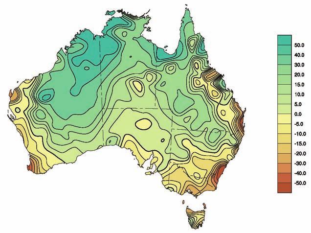
Living with Fire in NSW National Parks

A strategy for managing bushfires in national parks and reserves
                                                      2012–2021
© Copyright State of NSW and the Office of Environment and Heritage. The Office of Environment and Heritage, OEH and State of NSW are pleased to allow this material to be reproduced in whole or in part for educational and non-commercial use, provided the meaning is unchanged and its source, publisher and authorship are acknowledged. Specific permission is required for the reproduction of photographs. OEH has compiled this publication in good faith, exercising all due care and attention. No representation is made about the accuracy, completeness or suitability of the information in this publication for any particular purpose. OEH shall not be liable for any damage which may occur to any person or organisation taking action or not on the basis of this publication. Readers should seek appropriate advice when applying the information to their specific needs. Published by: Office of Environment and Heritage 59–61 Goulburn Street, Sydney, NSW 2000 PO Box A290, Sydney South, NSW 1232 Report pollution and environmental incidents Environment Line: 131 555 (NSW only) or info@environment.nsw.gov.au See also www.environment.nsw.gov.au Phone: (02) 9995 5000 (switchboard) Phone: 131 555 (environment information and publications requests) Phone: 1300 361 967 (national parks, climate change and energy efficiency information and publications requests) Fax: (02) 9995 5999 TTY users: phone 133 677, then ask for 131 555 Speak and listen users: phone 1300 555 727 then ask for 131 555 Email: info@environment.nsw.gov.au Website: www.environment.nsw.gov.au ISBN 978 1 74293 778 6 OEH 2012/0690 December 2012
Foreword
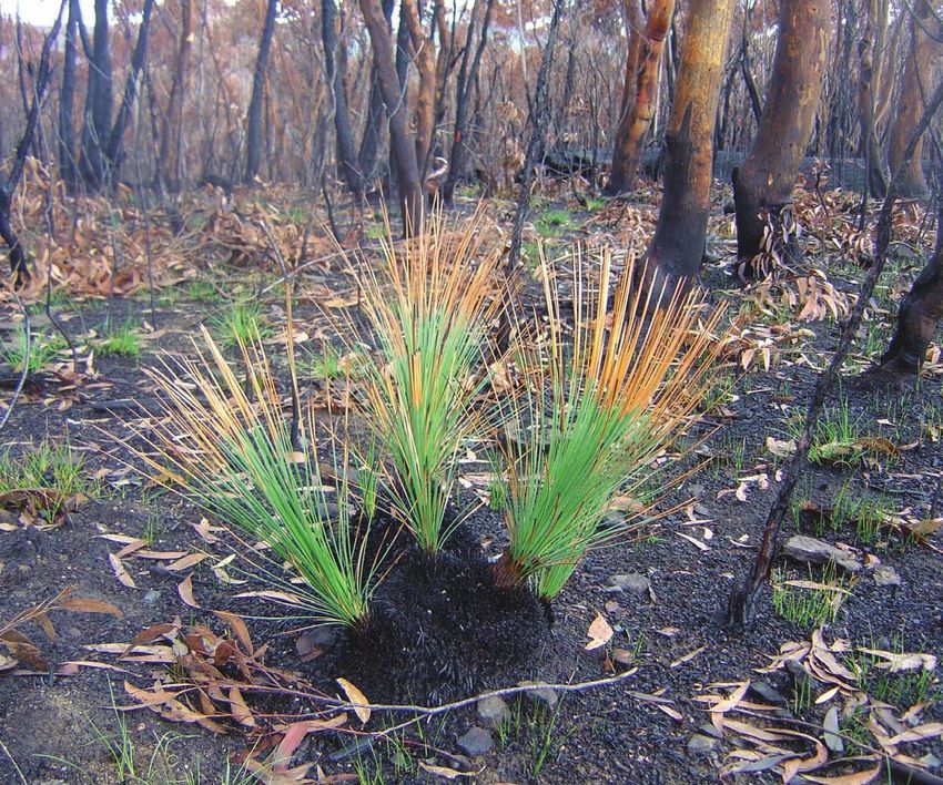
Fire is an integral part of Australia’s natural environment. New South Wales is one of the most
bushfire prone areas on the globe. Almost every community has been touched in some way
by bushfire and its aftermath.
Our climate, weather systems, vegetation and fuel characteristics and the rugged and remote
terrain of parts of New South Wales are all particularly susceptible to the ignition and spread
of fires. Each year thousands of bush and grass fires burn across the state. While many are
planned for hazard reduction purposes and for achieving land management and ecological
objectives, many fires are unplanned. Most unplanned fires are contained and extinguished
by firefighters before they cause significant damage. However, during severe, extreme or
catastrophic fire weather events, some bushfires can escalate to a size and severity well
beyond our fire suppression capability and will often pose a serious threat to life and
property. Inappropriate fire regimes, such as frequent fires, or absence of fire, can also pose a
significant threat to our Aboriginal and historic heritage, threatened species, ecological
communities, and landscape and catchment values.
We cannot bushfire proof our state. However, we can make sure the National Parks and
Wildlife Service works alongside all government agencies, our communities and our national
park neighbours to minimise the threat of bushfire where possible, and focus our efforts
where it counts most. We can also bolster our firefighting resources and skills so that we are
more ready than ever to respond quickly and efficiently to protect homes and communities,
and stop the spread of fire where possible.
This Living with Fire Strategy is aimed at presenting a state-wide approach to the
management of bushfires in our national parks and reserves over the next decade, consistent
with NSW 2021 and in response to the social, economic and environmental drivers and
current emerging threats we face. The strategy will be reviewed each year in order to
revalidate its principles, objectives and strategies.
The Hon. Robyn Parker MP
Minister for the Environment
Minister for Heritage
iiiiv
Contents

Foreword                                                                    iii

Preface                                                                    vii

Abbreviations                                                              viii

1 Introduction                                                               1

2 The context                                                                3
  2.1 Fire in NSW                                                            3
  2.2 Fire and people                                                        3
  2.3 Fire and communities                                                   4
  2.4 Fire and the environment                                               4
  2.5 Fire and fuels                                                         5
  2.6 Fire and risk management                                               6

3 Bushfires in NSW – long-term and recent trends                             7
  3.1 NSW population                                                         7
  3.2 Fire and weather                                                       8
  3.3 Fire and national parks                                              10
      3.3.1 Bushfire occurrence trends                                     10
      3.3.2 Area burnt by bushfires                                        10
      3.3.3 Causes of wildfires                                            12
      3.3.4 Origin of wildfires                                            13
      3.3.5 Size of bushfires                                              13

4 A coordinated approach to bushfire management                            15
  4.1 Responsibilities                                                     15
      4.1.1 Scope and scale of NPWS bushfire management responsibilities   15
      4.1.2 Cross-tenure fire management                                   15
      4.1.3 Coordinated bushfire management                                16
  4.2 Capabilities                                                         16
      4.2.1 Remote area firefighting                                       17
      4.2.2 Hazard reduction activities                                    17
      4.2.3 Incident management                                            18

                                                                                  v
5 The future: issues, challenges and risks 19
5.1 Population expansion in bushfire-prone areas 19
5.2 Ageing population and increasing community vulnerability 19
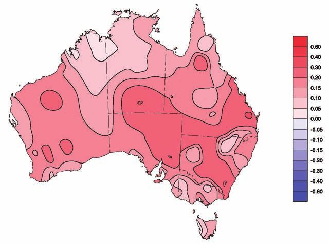
5.3 Climate change impacts 20
5.4 Long-term impacts of past fire management practices 21
5.5 Managing the future fire mix 22
5.6 Bushfire research priorities 22
6 Fire management vision, objectives and principles 24
7 Fire management strategies, actions and key performance
indicators 25
Glossary 33
Appendix A: Draft NPWS Bushfire Research Statement 35
Appendix B: Major bushfires in NSW 44
References 47
Figures
Figure 1: Trend in mean temperature and rainfall 1960–2010 8
Figure 2: Annual mean temperature anomalies for NSW 1910–2010 9
Figure 3: Southern Oscillation Index and major bushfire occurrence in
NSW 1876–2009 10
Figure 4: Trend in total area of parks and reserves and annual number of
wildfires 1976–2010 11
Figure 5: Percentage of area burnt on parks and reserves 1976–2010 12
Figure 6: Cause of bushfire ignitions on parks and reserves
2000–2010 (n=2886) 12
Figure 7: Origin of wildfire ignitions impacting parks and reserves
2000–2010 (n=2964) 13
Figure 8: Trend in the average annual size of bushfires in parks and reserves
1976–2010 13
Figure 9: Size class distribution of park bushfires 2000–2010 (n=2964) 14
Figure 10: Projected changes in average rainfall to 2050 21
viPreface
The NSW National Parks and Wildlife Service (NPWS), part of the Office of Environment and
Heritage, is a state government agency within the Department of Premier and Cabinet, and is
responsible to the NSW Minister for the Environment.
As a major land manager under the National Parks and Wildlife Act 1974 and one of the four
recognised fire authorities in NSW under the Rural Fires Act 1997, NPWS is committed to
managing bushfire and its associated risks in partnership with other NSW fire authorities, the
NSW Bush Fire Coordinating Committee (BFCC), and district bush fire management
committees, adjoining land owners and the community to minimise the threats associated
with severe bushfires and inappropriate fire regimes.
NPWS is also committed to maintaining biodiversity through the use of fire (ecological
burning), and the protection and conservation of natural and cultural heritage values,
including threatened species both on and off our national parks and reserves.
NPWS has adopted a comprehensive set of fire management policies and procedures to
guide and direct its approach to managing fires in our national parks and reserves. Individual
reserve fire management strategies have been prepared for all bushfire prone national parks
and reserves and are a priority for completion in newly acquired parks and reserves.
These strategies describe how fire will be managed at a park and reserve level. NPWS also
participates in the development of landscape-level bushfire risk management plans which
are prepared in accordance with the Rural Fires Act and which incorporate park and reserve
strategies. NPWS also employs and equips a substantial workforce which is fit, highly trained
and experienced in fire management, and which specialises in dry and remote area
firefighting techniques.
Bushfire risk factors are constantly changing. The population is growing and ageing and,
every year, the number of people living in bushfire-prone areas increases. The climate is
becoming warmer, and in many places it is also becoming drier. Large and intense bushfires,
which have been more frequent in the first decade of the twenty-first century than in
previous years, can threaten life, property, biodiversity and carry risk of injury to firefighters.
Managing bushfire impacts must also include monitoring sediment and nutrient loads in
water catchments and managing smoke impacts on air quality, greenhouse gas emissions
and wine production. In addition, native plants, animals and ecosystems are under increased
pressure from a range of threatening processes, including habitat fragmentation, climate
change, invasive species, land-use changes and altered fire regimes. A major challenge is
finding the right balance in our approach to bushfire management which addresses each of
these concerns.
viiAbbreviations
AFAC Australasian Fire and Emergency Service Authorities Council
APZ Asset Protection Zone
BAAT Burnt Area Assessment Team
BFCC Bush Fire Coordinating Committee
BFEAC Bush Fire Environmental Assessment Code
BFMC Bush Fire Management Committee
CERMB Centre for Environmental Risk Management of Bushfires
CRC Cooperative Research Centre
CSIRO Commonwealth Scientific and Industrial Research Organisation
DECC Department of Environment and Climate Change
DECCW Department of Environment, Climate Change and Water
EBMP Enhanced Bushfire Management Program
FIMS Fire and Incident Management Section
FMM Fire Management Manual
ICS Incident Control System
KPI key performance indicator
LMZ Land Management Zone
NPW Act National Parks and Wildlife Act 1974
NPWS National Parks and Wildlife Service
OEH Office of Environment and Heritage, Department of Premier and Cabinet
OFH overall fuel hazard
RART Rapid Aerial Response Team
RF Act Rural Fires Act 1997
RFMS reserve fire management strategy
RFS Rural Fire Service NSW
SFAZ Strategic Fire Advantage Zone
SOI Southern Oscillation Index
viii1 Introduction
The bushland and rangelands of New South Wales include a diverse range of landscapes in
which fire has been a significant and recurring natural event. Bushfire regimes (the combined
frequency, intensity, seasonality and spatial distribution of fires) have influenced and continue
to influence the current distribution, diversity, structure and composition of our ecosystems.
Human settlement into bushfire-prone areas and resultant changes to these natural fire
regimes can pose a considerable threat to human life, property and to the natural and
cultural values that are protected in our parks and reserves.
The NSW National Parks and Wildlife Service (NPWS) manages more than 860 terrestrial parks
and reserves in seven categories (national parks, nature reserves, state conservation areas,
karst conservation reserves, historic sites, regional parks and Aboriginal areas) covering more
than 7 million hectares, approximately 9% of NSW. About 90% of the area of these parks and
reserves is prone to bushfires and about 30% is declared wilderness. The area of parks and
reserves managed by NPWS will continue to increase over the next 10 years.
Our national parks and reserves contain significant heritage values, including old growth
forest, threatened plants and animals, wilderness, significant historic sites and Aboriginal
places, as well some of the state’s most popular tourism destinations. They are also places
which provide clean drinking water, clean air, and which sequester carbon. The parks and
reserves are surrounded by a mixture of land uses, including residential properties, critical
infrastructure, such as dams and transmission lines, and agricultural enterprises.
In accordance with the National Parks and Wildlife Act 1974 (NPW Act), NPWS is responsible for
protecting and conserving natural and cultural heritage values in our national parks and
reserves. Under the Rural Fires Act 1997 (RF Act), NPWS is also responsible for taking
‘practicable steps to prevent the occurrence of bushfires on, and to minimise the danger of,
the spread of bushfires on or from’, those parks and reserves.
In addressing these statutory obligations NPWS has adopted the following primary fire
management objectives:
• to protect life, property and community assets from the adverse impacts of fire
• to develop and implement cooperative and coordinated fire management
arrangements with other fire authorities, park and reserve neighbours and the
community
• to manage fire regimes in reserves to maintain and enhance biodiversity
• to protect Aboriginal sites and places, historic places and culturally significant features
from damage by fire
• to assist other fire agencies, land management authorities and landholders in
developing fire management practices that contribute to conserving biodiversity and
cultural heritage across the landscape.
1 Introduction 1These objectives are translated into fire management policies and procedures which apply to
parks and reserves across the state and at a local level are implemented through specific
reserve fire management strategies for each park and reserve.
This strategy provides a state-wide framework for fire management by NPWS. It identifies a
vision and a set of management principles that NPWS strives to implement in managing fire
and a strategic framework for achieving these goals over the next 10 years consistent with
Goal 28 of NSW 2021 – A plan to make NSW number one (NSW Government 2011) (see below).
The strategy aims to integrate and better position NPWS’s cooperative bushfire risk-
management efforts to manage current and emerging bushfire risks.
It also seeks to integrate operational resources, research capacity, technology and innovation
to achieve these outcomes and is supported by the NPWS Strategic Bushfire Research
Statement which outlines the bushfire research priorities for NPWS (Appendix A).
This strategy seeks to balance the social, economic and environmental aspects of fires, for an
integrated, balanced and comprehensive approach to bushfire management incorporating
cooperative fire research, prevention, mitigation, preparedness, and response and recovery
actions.
NSW 2021 – A Plan to Make NSW Number One
Goal 28: Ensure NSW is ready to deal with major emergencies and natural disasters.
Targets: By 2016, increase hazard reduction across NSW by increasing the:
• number of properties protected by hazard reduction works across all bushfire-prone
land tenures by 20,000 per annum
• annual average area treated by hazard reduction activities by 45%.
Priority actions: Limit bushfire severity by:
• establishing annual bushfire hazard reduction works targets for land management
agencies responsible for bushfire-prone lands consistent with the state target
• increasing the number and area of hazard reduction activities undertaken on
national parks and reserves.
2 Living with Fire in NSW National Parks2 The context
2.1 Fire in NSW
In NSW, as in other parts of south-east Australia, climate, severe weather systems, seasonally
flammable vegetation, topography, and recurring and sometimes multiple ignition sources,
combine to create one of the most bushfire prone environments in the world. Grasslands and
shrublands become flammable for varying periods each summer. In the understorey of
eucalypt-dominated forests and woodlands, flammable shrubs, grasses and leaf litter
accumulate in varying proportions. When these dry out sufficiently, they become fuel for
bushfires. In eastern NSW, in seasons of average or higher rainfall, moist areas such as
rainforest gullies, riparian zones and forests on sheltered aspects restrict the spread of fires to
drier parts of the landscape. However, during droughts these normally moist areas can dry
out, increasing the connectivity of flammable fuel in the landscape and creating the potential
for very large bushfires. In the rangelands of western NSW, seasons of above average rainfall
can give rise to prolific grass growth, which later cures in summer providing the fuel
conditions needed for large rangeland fires.
The weather pattern in NSW periodically brings extremes in fire weather, and strong, hot and
dry north-westerly winds that often contribute to extreme or catastrophic fire danger ratings.
Along the sea-breeze moderated coastal fringe, such extremes in fire danger are less frequent
than inland, but may often occur several times each year. In such weather conditions,
bushfires develop and spread rapidly, with uncontained fires reaching intensities well beyond
modern fire suppression limits, even in recently modified fuel areas. Periods of extreme fire
danger are recurring natural events in NSW. They are certain to continue and are likely to be
exacerbated by the effects of climate change over the next 10 years and beyond.
Lightning is a natural and seasonal source of fires, established in the Australian landscape for
hundreds of thousands of years, even before the arrival of Aboriginal people. Natural fires,
together with climate, landform and soils, have played a fundamental role in shaping the
biodiversity of Australia’s terrestrial ecosystems (Flannery 1994).
Sources of fire ignition are either from lightning or from human causes close to areas of rapid
urban expansion or access roads, and are more likely to occur on weekends during early
spring to late summer (Bryant 2008). Periodically, ignitions caused by multiple lightning
strikes will occur in remote or rugged areas and can overwhelm suppression capability.
Deliberate and accidental human-caused fires often occur on or preceding days of very high
or extreme fire danger and can quickly reach proportions beyond the limits of suppression.
2.2 Fire and people
The arrival of Aboriginal people in Australia commenced an interaction between humans, fire
and the environment that has extended over at least the last 40 to 60 millennia, and has
further influenced the distribution, structure and composition of ecosystems (Flannery 1994).
For NSW, knowledge about traditional Aboriginal burning practices and their impacts is
fragmentary, and assumptions about Aboriginal fire usage and impacts remain speculative.
It is thought Aboriginal people learnt to use fire in the landscape to manipulate the timing,
frequency, scale and intensity of fire occurrence (fire regimes), and as a result changed the
species composition and structure of some ecosystems (Ellis et al. 2004). Aboriginal peoples’
use of fire may have served a range of purposes, including the promotion of favoured food
sources, and manipulation of vegetation cover and condition for improved hunting, safety
and ease of travel through the landscape (Forest Fire Management Group 2007). When
Europeans arrived in NSW in the late 18th century, they inhabited landscapes shaped and, in
most cases, maintained by lightning and/or traditional Aboriginal burning induced fire
regimes (Whelan et al. 2006).
2 The context 3In south-eastern Australia, European settlement brought dramatic changes to land-use
systems and fire regimes, nowhere more so than in NSW. Through the 19th century, far-
reaching land-use change, principally to agriculture, extended relatively rapidly from the
coastal plains, through the major valley systems of the Great Divide and across the tablelands
and plains of inland NSW. This land-use change brought extensive vegetation clearing and
the introduction of livestock grazing and cropping, as well as pest animals and weeds,
contributing to landscape scale changes to vegetation cover, structure and composition,
animal habitats and watercourses. Land settlement also brought new and growing
communities settled in villages, towns and cities. These growing communities, the
infrastructure that links them and the rural enterprises that support them require protection
from the impact of bushfire. For these important reasons, effective fire suppression has
become a fundamental public safety management necessity across NSW.
The landscape condition changes that came with European settlement varied previous fire
regimes. Some have proposed that in some landscapes, such as the woodlands and
grasslands of inland NSW, historical fire frequency may have been reduced significantly.
In other areas, principally near urban population centres, arson and careless fire use have
resulted in more frequent high intensity summer fires. The evidence suggests a significant
increase in fire frequency since 1800, followed by a slight reduction over the past 50 years.
2.3 Fire and communities
Many communities in NSW choose to live in bushland settings, in rural or semi-rural areas, or
where urban areas abut or extend into bushland areas. The natural, aesthetic and amenity
values of our bushland are highly valued, but these same values can pose a significant threat
on days of extreme or catastrophic fire weather conditions. From time to time, bushfires burn
at intensities beyond the limits of modern suppression capacity, impacting communities,
infrastructure, rural assets and economies and natural resources. At their worst, these impacts
involve loss of human life, extensive property and economic damage and social and
environmental impacts. Such events are well documented in our history (Appendix B).
Today in NSW, fire-prone ecosystems, a fire-conducive climate, and vulnerable rural and
urbanised communities all intersect to create levels of bushfire risk which are amongst the
highest in the world. The need to protect our rural communities and those along the edges of
our cities and towns from bushfires presents our communities, land managers and fire
services with a great challenge.
2.4 Fire and the environment
Fire has been a recurring feature of Australian ecosystems over millions of years. As a result,
ecosystems and their flora and fauna have evolved to reflect particular fire regimes which
affect the functioning of ecosystems in numerous ways. For example, different fire regimes
may alter vegetation structure, change animal habitat, affect fuel accumulation and alter
nutrient and energy flows (Bradstock and Kenny 2003; Whelan et al. 2006). These in turn will
affect plant and animal distribution, the spread of disease such as root rot fungus
(Phytophthora spp.), changes in the composition of soil, and atmospheric carbon. A variety of
fire regimes, including occasional intense crown fires and low intensity frequent fires,
facilitates a diverse and rich mix of plants and animals, structural diversity in vegetation and
habitat and promotion of more robust ecosystem structures and functions.
4 Living with Fire in NSW National ParksHowever, altering the fire regime beyond the evolutionary adapted thresholds can disrupt
the functioning of those ecosystems, adversely affecting their health and diversity, and
potentially leading to structural change and local extinction of some species and
establishment of others; hence high frequency fire is listed as a key threatening process
under the Threatened Species Conservation Act 1995. When planning fire management
activities, NPWS uses biodiversity thresholds based on plant species functional types and life
history to identify the domain of acceptable fire intervals within broad vegetation types
(Kenny et al. 2004).
It is widely acknowledged that natural landscapes with a diversity of fire regimes have greater
biological diversity and ecological resilience than landscapes with a low diversity of fire
regimes (Bradstock et al. 1995; Bradstock and Kenny 2003; NSW Government 2004). NPWS and
other land managers are faced with a complex challenge in managing fire regimes to
maintain the health and resilience of these ‘fire-adapted’ ecosystems. A great variety of fire
regimes is required in order to maintain ecosystem health and diversity in a landscape
context. A most significant challenge for NPWS, and indeed all Australian land managers, is to
maintain appropriate fire regime diversity in the long term while meeting other important
land management objectives, including protection of life and property, infrastructure and
environmental services. To facilitate this, ongoing research is essential to establish and
maintain a current knowledge base and adaptive management approach for effective
bushfire management (see section 5.6).
2.5 Fire and fuels
Fuel is one of the fundamental elements required to sustain a fire. While other factors, such as
topography and weather, will greatly influence fire spread and intensity, fuel is the element
most easily manipulated for fire management. Hence hazard reduction is about reducing the
quantity and/or changing the structure of the available fuel.
Fuel is described and measured in layers. Fires generally start and develop in the surface layer
(litter from fallen leaves and twigs) and near-surface layer (grasses and suspended litter).
Ignition of elevated fuels (shrubs and saplings) will depend on the fire intensity and the
continuity between the surface and elevated layers. Crown fires require continuity from these
surface fuels through to the elevated or bark fuels, and usually occur under extreme fire
weather conditions which have created intense ground fires. Crown fires usually release
wind-borne embers which lead to dangerous spot fires ahead of the main fire front and
ember attack on nearby properties.
The quantity of fuel (fuel load) at any place is determined by many factors including
vegetation type, climate and productivity of the site, time and intensity of the last fire and
recent weather events. Models of fuel accumulation over time follow a negative exponential
curve, where fuel builds up rapidly for several years after a fire and then reaches a relatively
steady state level. Recent research work is helping to improve our knowledge of fuel
dynamics across the different NSW vegetation types (Watson 2011; Watson et al. 2012).
2 The context 52.6 Fire and risk management
It is neither possible nor desirable to eliminate bushfires in NSW – they are inevitable across
all fire-prone vegetation types. When high fuel loads, ignition sources and adverse weather
inevitably coincide, wildfires will result. Modern fire management requires the assessment,
measurement and mitigation of risks – to social, economic and environmental values. This
creates an imperative to work closely with adjoining land managers, community groups and
fire authorities to continually improve our understanding of bushfires, and to work together
in managing the risks associated with living in a fire-prone environment (Bradstock and
Kenny 2003; Whelan et al. 2006).
As the removal of hazards (fuel) is one of the key tools for reducing fire risks to both
communities and environmental values, managing the risks associated with wildfires will
entail improving community understanding and acceptance of the need to use prescribed
fire appropriately on private and public lands.
It is important, however, to acknowledge that there will always be a high residual risk in some
areas on days of catastrophic fire weather and that prescribed burning only temporarily
reduces fuel loads.
Fire is an unusual disturbance in that it can be both a threat and a requirement for
maintaining species richness in many ecosystems. When managing species and ecosystems,
long periods of time between bushfires can be detrimental, just as high fire frequency can be
harmful. Using prescribed fire appropriately (selecting the correct fire regime for the correct
vegetation community) is therefore an important factor for land managers.
NPWS also manages a broad range of cultural heritage. NSW has a rich cultural heritage that
forms an integral part of the contemporary landscape. The landscape encompasses many
aspects of Aboriginal heritage, including Aboriginal sites and artefacts, natural landforms,
sites of spiritual or ceremonial significance and native flora and fauna (totem species, bush
foods and medicines). Other types of cultural heritage include historic structures, roads,
modified landscapes and archaeological sites. Cultural heritage sites and artefacts may or
may not be susceptible to fire and have different requirements in order to protect them from
the impacts of fire. NPWS is committed to cultural heritage management principles and,
where applicable, includes cultural heritage guidelines in all NPWS reserve fire management
strategies.
Effective bushfire risk management requires a partnership between fire authorities and
communities. This partnership must be based on understanding the role of fire in the
environment, understanding and sharing responsibilities for managing risks (to people, the
environment and cultural heritage), and maintaining strong collaboration between fire
authorities, land managers and the community. Communities that have a better
understanding of the behaviour and management of bushfires do not necessarily experience
fewer fires or less property loss; however, they are more likely to have a better understanding
of the impacts of bushfire and take appropriate measures to minimise the risk to life and
property. It is therefore imperative for people living in bushfire-prone areas to understand
the risks of bushfire and to make preparations accordingly.
6 Living with Fire in NSW National Parks3 Bushfires in NSW – long-term
and recent trends
Due to a range of contributing factors, the risks associated with managing bushfire in national
parks and reserves have been steadily rising.
• The number of people living in adjoining bushfire-prone areas has significantly increased
(ABS 2010).
• Protected areas managed by NPWS have more than trebled since the 1970s (DECC 2008).
• Average annual rainfall in NSW has been declining over the past two decades, increasing
the duration and severity of bushfire seasons (Hennessy et al. 2005). In addition, water
demands have grown with increasing population size, highlighting the importance of
protecting drinking water catchments from adverse bushfire regimes.
• Fire weather has been getting progressively worse over the past two decades (Hennessy
et al. 2005; Lucas et al. 2007; DECCW 2010a) and it is likely that this trend will continue.
• The number of bushfires from human causes (accidental and deliberate) has been rising.
• The number of native plant and animal species, populations and communities listed as
threatened, and which have been identified as vulnerable to adverse bushfire regimes,
has been rising.
• The costs of bushfire and emergency management in NSW have been rising at
unprecedented levels.
In response to these rising risk factors, NPWS and other NSW fire authorities have over the last
20 years been broadening approaches to bushfire risk management and improving risk
management capacity.
3.1 NSW population
At both a national and a state level the population is both growing and ageing. Over the
past 50 years the NSW population has increased by more than 3.2 million (ABS 2008).
As a result, the number of people exposed to bushfire risks over that period has increased
significantly, as the urban edge of major population centres has continued to grow outwards
and into bushland-dominated environments. Also, new villages and towns have been
established in satellite and greenfield suburbs, many of which are within or adjacent to
bushfire-prone areas.
Continued strong growth in the NSW population is expected, with forecasts of about
1.2–1.4% pa, 8.12–8.22 million people by 2020 (BoM 2008). In addition, the growing popularity
amongst the ‘baby boomers’ population of seeking a ‘tree’ or ‘sea change’ has created
regions of high demand for residential development in peri-urban environments in regional
NSW, placing increasing pressure on managers of adjoining public lands, including parks and
reserves, in terms of managing the risk of bushfires.
3 Bushfires in NSW – long-term and recent trends 73.2 Fire and weather
Although NSW has a very variable climate, recent climate and weather trend analyses
undertaken by the Office of Environment and Heritage (OEH), the Bureau of Meteorology and
CSIRO indicate worsening bushfire weather trends over the last 50 years in NSW (BoM 2009;
Hennessy et al. 2005; Lucas et al. 2007; DECCW 2010a). This is particularly the case on the
North Coast, Far South Coast and South West Slopes where reduced rainfall and increased
temperatures overlap with relatively fire-prone vegetation communities in sclerophyll forest
and shrubland ecosystems, thereby increasing the potential for large and damaging wildfires
(Figure 1).
Climate trends over the last 100 years indicate an accelerating increase in average annual
temperature in NSW (Figure 2). For example, during the 1950s to 1980s, the annual average
temperature increased by 0.1°C per decade; since 1990 it has been about 0.5°C per decade.
Figure 1: Trend in mean temperature and rainfall 1960–2010 (°C/10 years)
Source: Bureau of Meteorology (product of National Climate Centre)
8 Living with Fire in NSW National ParksFigure 2: Annual mean temperature anomalies for NSW 1910–2007
2
Mean surface temperature anomaly (°C)
1
0
-1
-2
1910 1920 1930 1940 1950 1960 1970 1980 1990 2000 2010
Year
Source: BoM (2008)
In NSW there appears to be a positive relationship between major bushfires and a negative
Southern Oscillation Index (SOI), particularly so in the last 40 years (Figure 3). Sustained
negative values of the SOI often indicate El Niño episodes. El Niño conditions generally result
in below average rainfall over much of eastern Australia and a higher incidence and extent of
bushfires. Conversely, a lower incidence and extent of major wildfires has been observed
during positive SOI periods.
However, some of the most significant fire seasons on record have occurred following major
La Niña episodes, where conditions generally result in above average rainfall over NSW. These
major seasons have occurred in arid and semi-arid rangelands of western NSW where fuel
dynamics and fire exhibit different patterns when compared to the forests of eastern NSW. In
these rangelands, fire follows heavy rain, due to above-average growth of herbs and grasses
and rapid curing of fuel in spring and summer, in contrast to forests where extended periods
of drying are required as a prerequisite for major fires.
Also, a positive Indian Ocean Dipole (colder sea temperatures in the eastern Indian Ocean
relative to the western Indian Ocean) has also been strongly linked to drought cycles and
bushfire weather changes in NSW, especially when coinciding with a negative SOI.
These observations further inform our understanding of trends in climate and bushfire
occurrence and extent in NSW.
3 Bushfires in NSW – long-term and recent trends 9Figure 3: Southern Oscillation Index and major bushfire occurrence in NSW 1876–2009
1910–14 1965–67 1977–79 1987 1997
25 1877 1896 1904–05 1926 1939–41 1952–53 1968–69 1983–85 1991–94 2001–04
20
15
10
Average monthly SOI
5
0
-5
-10
-15 Major fire years
Average Monthly SOI
-20
Rolling 5-year monthly SOI
-25
1880 1890 1900 1910 1920 1930 1940 1950 1960 1970 1980 1990 2000 2010
Year
3.3 Fire and national parks
3.3.1 Bushfire occurrence trends
The area managed by NPWS has increased significantly over the last 30 years and NPWS fire
management responsibilities have also consequently increased. The number of fires starting
in or moving onto national parks and reserves has also increased in parallel with this trend
(but not at the same rate – see Figure 4) and with changes that have occurred in both climate
and local weather conditions. Years of highest ignition numbers and of area burnt on parks
and reserves coincide with those years with adverse bushfire weather conditions.
It is likely that the differences in the area managed and bushfire numbers over the last 30
years have been influenced by the acquisition of a greater proportion of parks and reserves in
the Central and Western divisions of NSW where wildfires are less frequently recorded.
However, this may also be a reflection of the improvements in community education,
regulation of arson and management of accidental ignitions in bushland areas when they are
established and managed as protected areas.
10 Living with Fire in NSW National ParksFigure 4: Trend in total area of parks and reserves and annual number of wildfires 1976–2010
8,000,000 500
Park and reserve area (ha)
450
7,000,000 Number of bushfires
Linear trend in 400
6,000,000 number of bushfires
Number of bushfires
350
Linear trend in park area (ha)
Park area (ha)
5,000,000
300
4,000,000 250
200
3,000,000
150
2,000,000
100
1,000,000
50
0 0
19 –77
19 –78
19 –79
19 –80
19 –81
19 –82
19 –83
19 –84
19 –85
19 –86
19 –87
19 –88
19 –89
19 –90
19 –91
19 –92
19 –93
19 –94
19 –95
19 –96
19 –97
19 –98
19 –99
20 –00
20 –01
20 –02
20 –03
20 –04
20 –05
20 –06
20 –07
20 –08
20 –09
20 –10
1
–1
76
77
78
79
80
81
82
83
84
85
86
87
88
89
90
91
92
93
94
95
96
97
98
99
00
01
02
03
04
05
06
07
08
09
10
19
3.3.2 Area burnt by bushfires
Annual area burnt statistics for parks and reserves indicate that severe fire seasons have been
more prevalent over the last 20 years (1990–2010). This trend has also been observed in the
USA, where a large and sudden increase in wildfire activity in the mid-1980s has been noted
with higher large-wildfire frequency, longer wildfire durations and longer wildfire seasons
(Westerling et al. 2006).
The percentage of area burnt on parks and reserves over the last 20 years from both
prescribed burns and from wildfires has averaged 3.6% per annum, or 3.8% over the last 10
years (Figure 5), or approximately 4% or 4.2% respectively if adjusted for bushfire-prone lands
only. The average ratio of wildfire area to prescribed burning area over this period is about 5:1.
One of the major challenges over the next 10 years will be to decrease this ratio of area burnt
from wildfire to prescribed burns, that is, to gain more management control over what gets
burnt. This will be achieved through an enhanced strategic prescribed burning program,
improved detection techniques and improved rapid response techniques for wildfires, thus
giving NPWS greater control over the intensity, timing and location of fires. This also supports
NPWS objectives of protection of life, property and community assets and management of
fire regimes to maintain and enhance biodiversity (see section 5.5).
3 Bushfires in NSW – long-term and recent trends 1145
Figure 5: Percentage of area burnt on parks and reserves 1976–2010
40
wildfire
40
total 35
35 prescribed fire
30
during previous 5 years
30
% of parks and reserves
total per annum – 10-year rolling average 25
25 total per annum – 20-year rolling average
20
20
15 15
10 10
5
5
0
0
7
9
1
3
5
7
9
1
3
5
7
9
1
3
5
7
9
1
–7
–7
–8
–8
–8
–8
–8
–9
–9
–9
–9
–9
–0
–0
–0
–0
–0
–1
76
78
80
82
84
86
88
90
92
94
96
98
00
02
04
06
08
10
19
19
19
19
19
19
19
19
19
19
19
19
20
20
20
20
20
20
3.3.3 Causes of wildfires
Lightning is the predominant natural cause of ignitions on parks and reserves, representing
about 30% of the total cause (Figure 6). This is especially the case in parks on the coastal
ranges and western slopes and plains where more than 30–40 ignitions may start from just
one dry storm. Increasing temperatures are expected to increase the number of lightning-
caused wildfires. The benefits of a rapid response firefighting capability are obvious in these
situations. The ability to quickly respond to multiple ignitions in remote areas greatly reduces
the costs and impacts of these fires, which can burn tens of thousands of hectares.
In parks that are located in high population areas such as the Sydney Basin, arson (16%),
suspected arson (18%), unknown causes (17%) and motor vehicle fires account for a much
higher number of ignitions. Human-induced fires may constitute offences against the law and
require formal and prompt investigation. These fires can threaten life and property, impact on
biodiversity, incur major suppression costs, divert NPWS resources away from other functions
and expose firefighters to unnecessary risk of injury, and therefore need to be carefully
managed and reduced in frequency.
Figure 6: Cause of wildfire ignitions on parks and reserves 1995–2010 (n=2886)
1%
2%
2%
4%
3% Lightning Miscellaneous
6%
31% Arson Power Line
Arson Suspected Motor Vehicle
17%
Legal burning-off Campfire
16%
18%
Illegal burning-off Unknown
12 Living with Fire in NSW National Parks3.3.4 Origin of wildfires
The ability to prevent the spread of wildfires from parks and reserves to adjoining properties
in accordance with the obligations for land managers under the RF Act is an important key
performance measure. Preventing the escape of wildfires from managed properties, although
virtually impossible under extreme fire weather situations, is nevertheless a useful indicator
of the success of strategic hazard reduction programs and of detection and response
capability.
Over the last 10 years, of the fires that started on NPWS-managed lands (or moved on to
NPWS-managed land from neighbouring properties), 89% have been controlled on park
(Figure 7). Of the wildfires that burn on parks and reserves, more than twice as many (25%)
escape from neighbouring properties into parks and reserves than escape off park (11%).
This is an impressive record for NPWS, particularly given the extent (56,000 km) and rugged
and remote nature of the boundaries of parks and reserves. This can also be a very useful
performance indicator of the effectiveness of detection, suppression and success of strategic
hazard reduction programs.
Figure 7: Origin of wildfire ignitions impacting parks and reserves 2000–10 (n=2964)
89% Started/moved on park > controlled on park (n=2643)
Started on park > moved off park (n=321)
11%
3.3.5 Size of bushfires
Despite climate change impacts, a weak but downward trend in the annual average size of
wildfires on parks and reserves has occurred over the last 35 years and NPWS aims for this
trend to continue (Figure 8). Improved bushfire detection and suppression effectiveness and
more strategic fuel management within parks and reserves may be a contributing factor to
this trend. Over the last 35 years, the average annual area burnt by wildfires on parks and
reserves is approximately 144,000 ha. This reflects the remote and rugged terrain, including
more than two million hectares of declared wilderness, in which NPWS undertakes the
majority of its bushfire suppression activities.
3 Bushfires in NSW – long-term and recent trends 13Figure 8: Trend in the average annual size of wildfires on parks and reserves 1976–2010
4000
3500
Linear trend in average annual fire size
3000
Annual average fire size (ha)
2500
2000
1500
1000
500
0
-77
-79
-81
-83
-85
-87
-89
-91
-93
-95
-97
-99
-01
-03
-05
-07
-09
-11
76
78
80
82
84
86
88
90
92
94
96
98
00
02
04
06
08
10
19
19
19
19
19
19
19
19
19
19
19
19
20
20
20
20
20
20
The size distribution of wildfires in any one year will vary according to weather patterns and
the coincidence of ignitions on days of extreme bushfire weather, and to the capacity of land
managers and fire services to quickly detect and safely contain ignitions. Average annual size
of wildfires will be greatly influenced by the few very large fires that coincide with extreme
weather conditions, therefore drought years will stand out in trends of fire history data
(Figure 8). Hence, to account for annual seasonal differences arising from shifts in climate
patterns, such as the SOI, trends in area burnt are measured as five- to 10-year rolling
averages.
The proportion of wildfires managed in various size classes is a more useful indicator than
average fire size for assessing effectiveness of detection and suppression capability.
Since 2000, 79% of all wildfires on NPWS reserves have been contained to less than 100 ha
in area (Figure 9).
Figure 9: Size class distribution of park bushfires 2000–2010 (n=2964)
1%
5%
15%
10,000 ha
22%
14 Living with Fire in NSW National Parks4 A coordinated approach to
bushfire management
4.1 Responsibilities
4.1.1 Scope and scale of NPWS bushfire management responsibilities
NPWS is responsible for the management of more than 860 national parks and reserves
across NSW, covering an area of approximately seven million hectares, a land base that
includes some of the most remote, rugged and bushfire-prone country in NSW. These areas
have been reserved to conserve their natural and cultural values, including biodiversity,
physical landscapes, Aboriginal sites, historic structures and recreational settings. The reserve
system is expected to continue to increase over the next 10 years in accordance with the
priorities identified in the New South Wales National Parks Establishment Plan 2008
(DECC 2008).
The responsibilities of NPWS extend to the protection and conservation of natural and
cultural heritage values across NSW, including Aboriginal sites, wildlife and threatened
species. In NSW there are more than 1000 native species, populations and ecological
communities listed as threatened with extinction. Of these, more than 400 species are
identified as being threatened by altered bushfire regimes.
Fire management is one of the most important tasks in managing protected areas and
biodiversity, and it is recognised that bushfire management must be fully integrated with
other aspects of protected area management. It also needs to be integrated with bushfire
management on adjacent lands, with planning undertaken at the landscape level
(DECCW 2010b).
NPWS has statutory obligations for bushfire management. Under the RF Act, NPWS has
responsibilities as both a public authority and a firefighting authority and has obligations for
the responsible management of bushfires on parks and reserves and for cooperating with
bushfire management on other lands in NSW. This includes the prevention of wildfires on
NPWS reserves and minimisation of the danger of spread on or from NPWS land under
Section 63 of the RF Act, the detection and suppression of wildfires on NPWS land and other
tenures in conjunction with other agencies under Section 44 of the RF Act, and the
implementation of risk management programs to protect life and property from wildfires.
4.1.2 Cross-tenure fire management
Fires do not recognise boundaries, and therefore we realise the importance of working
closely with neighbours and local brigades in taking a broader landscape-based approach to
bushfire management, with activities undertaken both on and off park based on jointly
agreed priorities, consistent with local bush fire risk management plans. The NPWS
approach includes:
• undertaking cooperative risk-planning and hazard-reduction activities with private
landholders
• undertaking fire trail access planning and works with neighbours
• actively engaging with neighbours before, during and after the bushfire season.
4 A coordinated approach to bushfire management 154.1.3 Coordinated bushfire management
NSW has a very effective framework and structure for multi-agency cooperative bushfire
management and planning, in which NPWS plays an active role along with NSW Rural Fire
Service (RFS), Fire and Rescue NSW and Forests NSW. NPWS is also a long-standing member of
the NSW Bush Fire Coordinating Committee (BFCC), which is responsible for coordinating a
cross-section of government and non-government organisations with an interest in the
prevention, mitigation and suppression of bushfires, and enabling these parties to develop
and progress policies and procedures aimed at ensuring a coordinated approach to major
issues. At a regional level, NPWS actively participates in most of the local bush fire
management committees throughout NSW and is an important contributor to coordinated
and cooperative bushfire planning and operations, and engages in joint training initiatives
with other agencies.
NPWS is an active member of the Australasian Fire and Emergency Service Authorities Council
(AFAC) and the Bushfire Cooperative Research Centre (CRC), and regularly provides resources
to assist with wildfire suppression in other Australian states and territories and for joint
international assignments, in accordance with formal cooperative agreements. NPWS is also
engaged in a multi-state Burnt Area Assessment Team (BAAT) with ACT Parks, Conservation
and Lands, and Parks and Wildlife Service Tasmania. BAAT facilitates a rapid and integrated
post-fire rehabilitation and fire recovery assessment of an area to ensure that local land
managers are provided with a report detailing fire impacts and areas that may need
immediate remediation or further investigation.
NPWS is also involved in wildfire prevention strategies and operates within the joint agency
Bushfire Arson Task Force that is represented by NPWS, NSW Police, RFS and Fire and Rescue
NSW. NPWS works closely with these partner agencies to investigate fires on NPWS-managed
land using appropriately trained and experienced staff, with responsibilities in assisting
investigations and reporting to Strike Force Tronto, in accordance with the NSW Coroner’s
guidelines.
4.2 Capabilities
Given the extensive nature of national parks and reserves and the legislative responsibilities
to manage the reserves for the protection of life and property and conservation values, NPWS
has invested in developing:
• the coordination of all bushfire management activities by a newly established Fire and
Incident Management Section, supported by bushfire ecologists within a Scientific
Services Division and by regionally based bushfire management specialists and teams
• a hierarchy of bushfire management policies and procedures (this strategy; Fire
Management Manual – FMM; branch and regional incident procedures; reserve fire
management strategies and NPWS Bushfire Research Statement) to guide the approach
taken with bushfire management in parks and reserves
• a well-trained, fit, accredited to national competency standards, and highly mobile
firefighting force of around 1350 staff who are equipped to undertake various firefighting
roles, including rapid response and remote area firefighting, and staff who specialise in
incident management
• a well-maintained fleet of firefighting vehicles, comprising a large number of light 4WD
(for example, Category 9 tankers) vehicles which are optimal for firefighting in rugged
country, together with a specially outfitted helicopter fleet with well-trained and
experienced pilots
16 Living with Fire in NSW National Parks• a government funded enhanced hazard reduction and rapid wildfire response program
for 2011–16
• an extensive network of more than 37,600 km of park roads, fire trails and management
trails
• bushfire prevention activities which include education and regulation programs on the
use of fire in parks and reserves
• community engagement at a local level through programs such as RFS Hotspots and
FireWise
• a risk-based level of preparedness of regional staff enabling early detection and safe and
rapid response capability to bushfires
• cooperative arrangements (joint management plans and agreements) with adjoining
states and territories and with other firefighting agencies and peak bodies.
4.2.1 Remote area firefighting
NPWS maintains dedicated aircraft and employs seasonal remote area firefighting crews in
conjunction with RFS during the bushfire danger period to rapidly and safely respond to
wildfires, especially in remote and difficult to access areas. The remote area firefighting
capacity includes:
• conducting specific training for helicopter winching and hover exit for remote firefighters
• maintaining a fleet of specially equipped helicopters for remote area firefighting
• conducting fitness testing for all staff involved in on-ground fire management activities
• employing highly trained teams of remote area firefighters
• following the Joint Operational Protocol for Remote Area Firefighting.
As a result, nearly 80% of fires over the last 10 years have been contained to an area of less
than 100 ha (Figure 9).
4.2.2 Hazard reduction activities
There is a strong commitment from NPWS to reduce the risk of potential damage from
bushfires to park values and to neighbours. Addressing this requires a multi-faceted approach
that includes appropriate planning principles, community education and fuel management.
A standard bushfire management zoning system is used in all parks and reserves to identify
the fire management intent for a specific area as follows:
• Asset Protection Zones (APZs): to protect human life, property and highly valued public
assets and values
• Strategic Fire Advantage Zones (SFAZs): to provide strategic areas of fire protection
advantage which will reduce the speed and intensity of wildfires, and reduce the potential
for spot fire development. To aid containment of fires to existing management boundaries
• Land Management Zones (LMZs): to maximise the biodiversity value of ecosystems, to
minimise the risk of extinction through inappropriate fire regimes, and to reduce the
likelihood of the spread of fires.
Part of the fuel management approach includes conducting hazard reduction activities to
reduce fuel on parks and reserves, with priority to APZs and SFAZs. Hazard reduction can
include both prescribed burning and mechanical approaches, such as slashing and mowing
to remove or reduce vegetation. The NPWS approach includes:
• undertaking annual reviews of reserve fire management strategies for all parks and
reserves, each of which guides hazard reduction activities
4 A coordinated approach to bushfire management 17• using a state-wide bushfire zoning system to help prioritise hazard reduction to reduce
the risks to life and property while maintaining biodiversity values in the broader
landscape
• using the Bush Fire Environmental Assessment Code (BFEAC – RFS 2006) for NSW, where
applicable, to streamline the issuing of hazard reduction certificates with appropriate
environmental conditions
• implementing a prioritised hazard reduction program in cooperation with bush fire
management committees which is focused on areas of highest risk within APZs, most of
which are on or, more usually, adjacent to park boundaries
• maintaining appropriate and diverse bushfire regimes through prescribed burns in order
to maintain ecosystem structure and functioning in parks and reserves.
Since 2005, NPWS has regularly undertaken more than 50% of the total area of prescribed
burning in NSW despite only managing about 25% of the state’s bushfire-prone lands.
For example, in 2009–10 NPWS carried out 60% of the total area of prescribed burning
undertaken in NSW.
4.2.3 Incident management
NPWS will continue to maintain a high level of capacity in bushfire management,
particularly in the areas of planning and responding to remote area fires, and in
implementing a well planned, prioritised and strategic approach to its prescribed burning
program. The NPWS approach includes:
• applying the Australasian Inter-service Incident Management System and related policies
and procedures for managing bushfires, consistent with all other fire and emergency
service agencies in Australia
• in conjunction with RFS, actively communicating with the public during incidents,
including through community awareness programs, incident briefings, website
information and letterbox drops
• preparing and implementing a biennial fire training plan and registered training
organisation status to maintain staff competency and currency in bushfire management,
including fire fitness testing
• developing and delivering role-specific bushfire training courses, such as for crew leaders,
divisional commanders, air operations managers and air observers, in order to develop
skilled operators with state of the art knowledge and capability
• actively participating in cooperative bushfire training with RFS, Fire and Rescue NSW and
Forests NSW, including incident management and aviation training
• adopting a guarantee of service approach to regional bushfire management capability
and equipment standards
• working cooperatively with NSW Police and participating in local emergency management
committees and the State Emergency Management Committee
• establishing BAATs to enable rapid and integrated post-fire rehabilitation and fire
recovery; each team provides local managers with a report detailing issues caused by fire
and areas that may need immediate remediation or further investigation, and makes
recommendations covering soils and erosion, flora, fauna, assets and infrastructure, and
cultural heritage items.
18 Living with Fire in NSW National ParksYou can also read