De-Population Trends, Patterns and Effects in Uttarakhand, India - A Gateway to Kailash Mansarovar - ICIMOD Working Paper 2017/22 - HimalDoc
←
→
Page content transcription
If your browser does not render page correctly, please read the page content below
ICIMOD Working Paper 2017/22

Kailash Sacred Landscape Conservation and Development Initiative (KSLCDI)

De-Population Trends, Patterns and
Effects in Uttarakhand, India –
A Gateway to Kailash Mansarovar

                                                                            1
About ICIMOD

    The International Centre for Integrated Mountain Development (ICIMOD), is a regional knowledge
    development and learning centre serving the eight regional member countries of the Hindu Kush
    Himalaya – Afghanistan, Bangladesh, Bhutan, China, India, Myanmar, Nepal, and Pakistan – and
    based in Kathmandu, Nepal. Globalisation and climate change have an increasing influence on
    the stability of fragile mountain ecosystems and the livelihoods of mountain people. ICIMOD aims
    to assist mountain people to understand these changes, adapt to them, and make the most of new
    opportunities, while addressing upstream-downstream issues. We support regional transboundary
    programmes through partnership with regional partner institutions, facilitate the exchange of
    experience, and serve as a regional knowledge hub. We strengthen networking among regional
    and global centres of excellence. Overall, we are working to develop an economically and
    environmentally sound mountain ecosystem to improve the living standards of mountain populations
    and to sustain vital ecosystem services for the billions of people living downstream – now, and for
    the future.

    About KSLCDI

    The Kailash Sacred Landscape Conservation and Development Initiative (KSLCDI), which
    covers an area of 31,252 sq.km, is a collaborative programme being implemented
    across the borders of China, India, and Nepal. As such, KSLCDI transcends geographical
    boundaries, and has evolved through a participatory and iterative process into a
    transboundary initiative. It involves various local and national research and development
    institutions working in different capacities in various regions of the three countries.

    The programme aims to achieve long-term conservation of ecosystems, habitats and
    biodiversity, while encouraging sustainable development, enhancing the resilience of
    communities in the landscape, and safeguarding cultural linkages among local populations.

    The KSLCDI is funded by Department for International Development (DFID) - UK Aid and
    Bundesministerium für Wirtschaftliche Zusammenarbeit und Entwicklung/ Deutsche Gesellschaft für
    Internationale Zusammenarbeit (GIZ) GmbH.

    Contact person: Amina Maharjan amina.maharjan@icimod.org

    ICIMOD gratefully acknowledges the support of its core donors: the Governments of Afghanistan,
    Australia, Austria, Bangladesh, Bhutan, China, India, Myanmar, Nepal, Norway, Pakistan,
    Sweden, and Switzerland.

2
ICIMOD Working Paper 2017/22

De-population Trends, Patterns and
Effects in Uttarakhand, India – A
Gateway to Kailash Mansarovar

Authors
Shekhar Pathak1
Lalit Pant2
Amina Maharjan3

International Centre for Integrated Mountain Development (ICIMOD), Kathmandu, Nepal
October 2017

1ShekharPathak, Professor emeritus, Kumaon University
2Lalit
    Pant, Researcher, People’s Association for Himalayan Research
3Amina Maharjan, Livelihood Specialist, ICIMOD.

                                                                                      i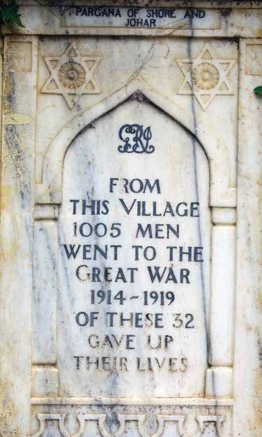
Copyright © 2017
     International Centre for Integrated Mountain Development (ICIMOD)
     All rights reserved, published 2017

     Published by
     International Centre for Integrated Mountain Development
     GPO Box 3226, Kathmandu, Nepal

     ISBN 978 92 9115 549 1 (printed)		                       978 92 9115 548 4 (electronic)

     Production Team
     Shradha Ghale (Consultant editor)
     Christopher Butler (Editor)
     Dharma R Maharjan (Layout and design)

     Photos:
     Anil Karki, Himani Upadhyaya, Lalit Pant, Shekhar Pathak, Victor Smetacek

     Printed and bound in Nepal by
     Quality Printers Pvt. Ltd., Kathmandu, Nepal

     Reproduction
     This publication may be reproduced in whole or in part and in any form for educational or non-profit purposes without
     special permission from the copyright holder, provided acknowledgement of the source is made. ICIMOD would appreciate
     receiving a copy of any publication that uses this publication as a source. No use of this publication may be made for
     resale or for any other commercial purpose whatsoever without prior permission in writing from ICIMOD.
     The views and interpretations in this publication are those of the author(s). They are not attributable to ICIMOD and do not
     imply the expression of any opinion concerning the legal status of any country, territory, city or area of its authorities, or
     concerning the delimitation of its frontiers or boundaries, or the endorsement of any product.

     Note
     This publication is available in electronic form at www.icimod.org/himaldoc

     Citation: Pathak, S., Pant, L., Maharjan, A. (2017) De-population trends, patterns and effects in Uttarakhand, India – A
     gateway to Kailash Mansarovar. ICIMOD Working Paper 2017/22. Kathmandu: ICIMOD

ii
Contents
Acknowledgements                                                                        iv

Abbreviations                                                                            v

Executive summary                                                                       vi

An introduction to KSL India - District Pithoragarh                                      1
 Demography and Other Descriptions                                                       1

History of Migration in the Region                                                       3
  Pre-colonial Period                                                                    3
  Colonial Period                                                                        4
  Post-Colonial Period                                                                   6
       The Three Turning Points: 1960, 1962 and 1967                                     6
       War induced disaster                                                              8
       Disaster induced displacement                                                     9
  Migration in the Twenty-first Century                                                 10
       Growth of industrial sector in the plains                                        10
       Stagnating agriculture sector in the mountains                                   12

Findings from the Askot Arakot Abhiyan                                                  14

Current migration scenario                                                              16
 Shift from Individual Temporary Migration to Family Permanent Migration                16
 Migration by Caste and Class                                                           17
 Remittances: Trends and Capacities                                                     18

Depopulation and its effect on the socio-ecological systems at origin                   19
 Land Fallowing                                                                         19
 Ecological System - Human-Wildlife Conflict and Invasive Species                       21
 Declining Vibrancy of Village Economy                                                  21
 In-migration: Transboundary and from Other States                                      22
 Unplanned Rapid Urbanisation                                                           23

Lives and livelihoods in destination                                                    24
  Importance of Social Capital and Network in New Destinations                          24
  Fading ‘Transvillage Ties’                                                            24
  Struggle for a New Identity, Culture and Livelihoods                                  25
       Struggle for land continues                                                      25
       Loss of old identity and creation of new identities                              25
  Transitioning from Traditional to Modern Vocational Skills                            26

De-population: Challenges and a way forward                                             27
 Need for a Policy Shift – From Protection to Sustainable Local Development             27
     Short run policy focus: meeting the basic needs of people                          27
     Long run policy focus - Promotion of new inspirations and aspiration among youth   29

Conclusions and Recommendations                                                         30

References                                                                              31

                                                                                             iii
Acknowledgements
     We would like to thank a number of persons for the successful completion of this publication. First, we would like
     to thank the Central Himalayan Environment Association (CHEA), particularly executive director Pankaj Tewari
     for his support in conducting the study. Pankaj sat with us for many long discussions about study design and data
     collection. CHEA kindly arranged all the logistics for our field trips and access to the study informants.

     We would also like to thank Himani Upadhyaya, Anil Karki and Naveen Bisht of CHEA for their support in the field
     work in the Pithoragarh villages and in the settlements at the foot hills in late 2016. Not only did they assist with
     data gathering, but they also helped collected secondary data that provide quite valuable to our writing. Bhupen
     Mehta provided a district map of Pithoragarh with necessary details to facilitate our study.

     We also extend our sincere gratitude to Raghubir Chand (Kumaon University, Nainita, India), B.R. Pant, and Beatrice
     Knerr (University of Kassel, Germany) for providing valuable feedbacks on early drafts of this manuscript.

     Our greatest thanks go to the many friends and villagers Pithoragarh, Berinag, Dharchula, Munsyari, Gangolihat,
     Ganai-Gangoli, Thal, Jhulaghat, Didihat, Narayan Nagar, Haldwani, Lalkuan, Bindukhatta, Khatima, Tanakpur,
     Sitarganj and countless other sites who helped us connect with people to hear their migration histories.

     Also we express our gratitude to the participants in the ‘Diversity Fair’ organized by the G.B. Pant Institute of
     Himalayan Environment & Sustainable Development at Gangolihat in December 2016. These participants provided
     valuable thoughts and ideas for sustainable mountain development.

     Lastly, we would like to thank the abiding support provided by Rajan Kotru (ICIMOD), Ranbeer S. Rawal (G.B. Pant
     Institute of Himalayan Environment & Sustainable Development,), and Gopal S. Rawat (Wildlife Institute of India,
     Uttarakhand) from the design phase to the completion of this study.

iv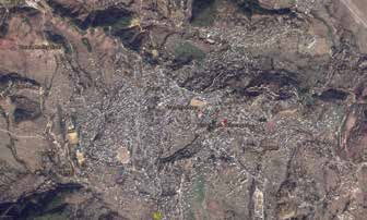
Abbreviations

AAA: 		     Askot Arakot Abhiyan

BPL: 			            Below Poverty Line

BRO: 		     Border Roads Organization

CRPF: 		    Central Reserve Police Force

DRDO: 		    Defence Research and Development Organization

GSDP: 		    Gross State Domestic Product

IDP - 		    Internally Displaced Persons

INR: 		     Indian Rupees

ITBP: 		    Indo Tibetan Border Police

JCO: 		     Junior Commissioned Officer

JRY: 			    Jawahar Rozgar Yojana

KMVN: 		    Kumaon Mandal Vikas Nigam

MGNREGA:    Mahatma Gandhi National Rural Employment Guarantee Act

MLA: 		     Member of Legislative Assembly

NCO: 		     Non-commissioned Officer

NHPC: 		    National Hydroelectric Power Corporation

OBC: 		     Other Backward Caste

PAHAR: 		   People’s Association for Himalaya Area Research

SC: 			     Scheduled Caste

SIIDCUL:    State Infrastructure and Industrial Development Corporation of Uttarakhand

SPF: 		     Special Protection Force

SSB: 		     Sashastra Seema Bal

ST: 			     Scheduled Tribe

UP: 			     Utter Pradesh

                                                                                         v
Executive Summary
     The Kailash Sacred Landscape in India (KSL India) encompasses large parts of the Pithoragarh district and portions
     of the Bageshwar district. As KSL India is situated at the tri-junction of India, Nepal, and the Tibetan Autonomous
     Region of China, its northern and eastern boundaries have international significance, which makes this area
     politically sensitive as well. The government of India formed the Pithoragarh district in the state of Uttar Pradesh (now
     Uttarakhand) in 1960 to accelerate the pace of development in this border area. Like many of its neighbouring
     mountainous districts, Pithoragarh has a long history of migration.

     Human mobility is an integral part of mountain livelihoods. Initially, mobility and migration took the form of
     community explorations to hunt, gather, and create settlements. Later, trade and pilgrimage routes were developed
     along the primitive trails through Himalayan passes. In today’s modern industrial context, villages developed as a
     major source of human labour for industries and urban centres. Although migration has changed in form over the
     years, it has remained a constant livelihood strategy for mountain families over centuries.

     Today, however, the picture is a little different. As worldwide human mobility rates continue to rise to unprecedented
     levels, migration from mountain areas like Pithoragarh has raised concerns about de-population, “permanently
     locked houses,” and the formation of “ghost villages.”

     In this study, we use mixed methods to derive a clearer picture of migration trends, patterns, and drivers and the
     resultant socio-demographic changes. To do this we review historical documents on human mobility and migration
     in the study area from pre-colonial to recent times, and complement this data with the findings of five decadal
     survey tours (1974, 1984, 1994, 2004, and 2014). We analyse present migration based on participatory fieldwork
     conducted in November-December 2016, which included several focus group discussions and interviews with key
     informants from selected villages in all eight blocks of Pithoragarh district. We draw additional information from our
     notes taken at a ‘Diversity Fair’ (December 2016) that included sessions on identifying and discussing key social
     challenges and potential solutions for KSL India. Excerpts from relevant secondary data round out our study.

     Historical Patterns and Drivers of Migration
     We start with a short profile of major drivers and their impact on migration patterns over time (including key events)
     – pre-colonial (before 1815/1816), colonial period (1815/16 – 1947), post-colonial period (1947-2000), and the
     twenty-first century (2000-2016). The migration history of Uttarakhand shows that until the independence of India,
     the government focused on the exploitation of resources, including human labour. Even after India’s independence,
     national security priorities have overruled the development needs of the mountainous areas of Uttarakhand,
     including Pithoragarh. Following the Sino-India War of 1962, the traditional integrated livelihoods of people in
     Pithoragarh were severely disrupted, and, over time, slowly disappeared. Subsequent wars have provided significant
     income and employment opportunities in the district. As a result, youth began leaving subsistence integrated agro-
     based livelihoods to take defence sector jobs and salaried jobs in the public and private sector. Most migration in
     Uttarakhand, including Pithoragarh, is intra-state. But with increased education and widening migration networks,
     migration patterns are slowly shifting to become interstate. The stagnating agriculture sector has served both as a
     cause and consequence of migration and over the years resulted in large-scale land fallowing.

     Present Migration Situation
     After the formation of Uttarakhand in 2000, the state has witnessed impressive economic growth, consistently above
     the national average. However, the government’s work to ensure a steep and steady economic growth did not
     include a focus on equitable pattern across the districts. As a consequence, most of the growth in industries and
     employment has been limited to the plains districts of Haridwar, Udham Singh Nagar, and parts of Dehradun and
     Nainital. Other hill districts have lagged far behind these standards. In the modern context this income and growth
     gap has become a driver for massive outmigration from the mountains to the plains.

vi
We summarise the major findings about present migration trends in Uttarakhand:
Shift underway from individual temporary labour migration to permanent family migration. This has resulted in
the development of ‘ghost villages’ and ‘ghost houses’.
For poor families still living in the villages, one or more male members are still involved in labour migration and send
home remittances (between INR 3,000–6,000 per month), which are an important source of household income.
Large-scale permanent fallowing of agricultural land due to outmigration of entire families.
Increase in human-wildlife conflicts that hinder subsistence farming and make poor farmers more vulnerable
(triggering additional outmigration).
In areas of high migration, social collectivism breaking down and stewardship of productive ecosystems inhibited.
Migrants from outside the region bridge the labour shortfall in KSL, but introduce potential for social conflict.
Low access to education and development weakens youth retention in the villages.
Education and development of local youth can reduce outmigration, but only if improved and innovative
employment, entrepreneurship and other economic opportunities become available in villages.
De-population Challenges Facing Policy Makers and Ways Forward
Outmigration from local areas is a major driver of the socio-demographic change observed in KSL India, one that
has challenged social collectivism and stewardship of local ecosystems and indirectly contributed to the degradation
of society as well as ecosystems on which society depends. Reducing this trend is a major challenge facing the
policy makers today. As our study reveals, lack of development in the mountains is a major driver for such massive
outmigration from these areas. While the developmental needs of local people once focused on food and shelter, the
scope has widened to include access to quality education and health care. In order to reduce the present migration
trends, the governments of India and Uttarakhand need to draw a broad and abiding focus on sustainable mountain
development. Without this, there is little reason to think that outmigration from KSL India will not continue unabated.
In this light, we offer some policy recommendations for addressing these challenges:
Short run policy focus: In the short term, policy should focus on meeting basic needs (food, health, education,
and employment) and attracting individual migrants back home with improved employment opportunities. As one
example, mountain niche products can provide potential for local economic growth. High-value non-timber forest
products such as yartsagunbu (keeda jadi) have huge market potential for local development in the high Himalaya.
In the lower ranges, small-scale commercial agriculture and its potential to add value through processing provide
enhanced economic and employment opportunities, even to educated youth. However, the problems of small
land holdings and human-wildlife conflicts need to be addressed before such programmes can succeed. Similarly,
heritage tourism with equitable benefits is another potential area that could boost local development.
Long run policy focus: The aspirations of youth for a permanent and salaried jobs in defence, government, and
the private sector has resulted from a lack of policy focus on the landscape context of KSL India. In other words,
mountain perspectives are not properly considered in state and national policy making. It will take time to reverse
these aspirations in young men as these notions are imbued with ideas of success and masculinity. Therefore,
enhanced awareness campaigns such as ‘Nurturing Himalaya’ should be supported with key development
investments that are youth-centric.
In order to achieve these short- and long-term goals, we suggest the following:
Increased planning dialogue with stakeholders, including private sector and civil society representatives
Adoption of a landscape approach in planning that combines stakeholder priorities and applied scientific knowledge
to design long-term plans that strike a necessary balance between conservation and socio-economic development
Introduce sustainable mountain development early in the academic curricula and vocational education in order
to build the confidence, pride and creativity of youth
Promote collective production systems for larger outreach through value chain approaches
Incentivize absentee landlords and willing stakeholders to put ‘ghost villages’ and ‘ghost houses’ to use in local
development efforts and the preservation of ecosystem services
Introduction of intermediate technologies for making rural life a bit comfortable. These technologies can be
introduced in agriculture, animal husbandry, horticulture, irrigation, water conservation, solar power and public
transport including gravity ropeways for good and village products.
Using the experience and expertise of diaspora.
vii
viii
An Introduction to KSL India –
District Pithoragarh
Pithoragarh district, which lies between 29.29˚ to 31.1˚ latitude North and 78.8˚ to 81.3˚ longitude East,
is situated at the tri-junction of Tibet (TAR), Nepal and India. Since its northern and eastern boundaries are
international it assumes great strategic importance and is, obviously, a politically sensitive area. Pithoragarh was
created on 24 February 1960 to accelerate the pace of development in the border area. The district was divided
into four subdivisions: Dharchula, Didihat, Munsyari and Pithoragarh, each forming a tehsil (Saxena, 1979). In May
1972, Champawat, hitherto under Almora district, was added as its fifth tehsil. Later, in 1996 a sizeable section of
the southern sub-Himalayan tract of the district was formed as a new district named Champawat. Pithoragarh district
is spread across the catchments of four rivers: the Kali (Kutiyangti, Dhauli East, Lisseryangti, Ailagad); the Gori
(Gunkhagad, Panchhugad, Ralamgad); the Ramganga East (Birthigad, Gorghatya, Kalpani and Salikhetgad); and
the Saryu (Pungargad, Karmigad, Gomti, Kuloor, Jataganga and Panar).

The district, an integral part of Kailash-Mansarovar Sacred Landscape, comprises the three longitudinal
physiographic divisions, namely the Lesser Himalaya, the Great Himalaya and the Trans-Himalaya. The Lesser
Himalaya is suited for habitation and cultivation and tehsils Pithoragarh, Gangolihat and Didihat are spread out in
this zone. Dharchula and Munsyari fall partly in the Lesser Himalaya and partly in the Great and Trans-Himalaya
(Byans, Darma and Chaudans valleys of Dharchula and Malla and a part of Talla Johar of Munsyari).The Great and
Trans-Himalayan regions have peaks, passes, glaciers and origins of the rivers. It does not have flat plains, though
there are fertile valleys such as the Sor valley.

The district also has snow-covered peaks like Panchchuli (highest 2nd peak 6,904 m), Rajrambha (6,537 m),
ChirigWe (6,569m), Nagalphu (6,410 m), Sutila (6,323m), Hardeol (7,151m), Tirsuli (7,074m) and Nandakot
(6,861m), with glaciers like Milam, Panchhu, Ralam, Balati-Panchchuli, Namik, Nalphu, Salang, Sankalpa,
Kalabadan, etc. Snow-covered and grassy/forested mountains with steep and overhanging rocks, deep river valleys,
widespread glaciers, and alpine meadows (bugyals) with valleys of flowers grace the district. The alpine environment
is home to rare wildlife and the last refuge for endangered species like musk deer, snow leopard and snow cocks.

Human settlements are generally situated on undulated tracts of land along the valleys and gentle mountain slopes.
Big frontier villages include Milam, Martoli, Pachhu, Ganghar (Johar); Bon, Filam, Baling (Darma) and Gunji, Nabi,
Ronkong and Kuti (Byans) (Pant L, 1982). Pithoragarh town and many surrounding villages are located on the flat
wide Sor valley (Pant R, 1991).

This is a district with many high Himalayan passes connecting the landscape across the border. Passes such as
Lipulekh (5453 m), Limpia Dhura, Lawe Dhura, Kungri Bingri La, and Keogad open up to the Kailash Sacred
Landscape region in western Tibet. The traditional pilgrimage route to Kailash-Mansarovar is documented
in Manaskhand (part of Skand Puran), which passes through many ancient places in Pithoragarh district
(Pranavananda, 1950). Pithoragarh, with a small part of Bageshwar district, comes under the Kailash Sacred
Landscape (India) and has the first official route to Kailash-Mansarovar along the Kali River (since its reopening
in 1981). These Himalayan passes were actively used by Bhotiya (Shauka) traders and pilgrims to enter the marts
of western Tibet and pilgrim places like Teerthapuri and Kailash-Mansarovar before 1960 (Pranavananda, 1938,
1939).

Demography and Other Descriptions1
The total geographical area of Pithoragarh district is 7090 sq.km. Champawat and Almora districts lie in the south
and southwest, and Bageshwar and Chamoli districts are in the west. It has two international borders- Nepal in
the east and Tibetan Autonomous Region of China in the north. Today it has twelve tehsils and eight development
1
    Data in this section is from Census 2011 http://www.censusindia.gov.in/2011census/dchb/DCHB.html

                                                                                                                       1
blocks with a total population of 483,439 with 114,730 families (average family size of 4.2) as per the census of
2011. Out of the total population, about 49.5 percent are male, about 25 percent Schedule Castes (SC) and 4
percent Scheduled Tribes (ST). The population density has increased from 65 persons per sq. km in 2001 to 68 in
2011, but it is still the third least populous district in the state after Uttarkashi (41) and Chamoli (49).The literacy
rate is 82 percent (male 93% and female 72%). Sex ratio is 1020 (for under 6 years, it is 816).
Pithoragarh has 1675 revenue villages, 669 village panchayats and 1051 van (forest) panchayats. The number of
van panchayats is highest in the state after Pauri (1684) and Almora (1543). Forest accounts for 30% of the total
geographical area of the district and the forest cover has declined from 2104 sq. km in 2001 to 2094 sq. km in
2011. The forest cover is low (after Haridwar at 26% and Udham Singh Nagar at 21%) in the district as it lies in the
higher Trans-Himalayan region. A large part of the district is under Askot Sanctuary and the northwest part touches
Nanda Devi National Park.
The total number of government primary schools in the district is 1384, secondary schools is 366 and inter colleges
is 232. There are six government colleges and one private engineering college. According to the census, there are
three towns but it can be said that all tehsil headquarters have grown into towns though only some of them have
been given the status of municipal boards. Actually these towns are the signs of local migration within blocks and
tehsils. After the Indo-China war, as in other Indo-Tibet border ares, Indo-Tibet Border Police (ITBP) was established
in Pithoragarh district.
The largest town and headquarter of the district is Pithoragarh with a population of 56,044 (52% male) with 14,036
families of mean size 4. But this population figures might be undercounted as often census population fails to
capture the mobile/floating population. The total number of SC population in this town is 8067 and ST population
is 1051. The sex ratio is 924 (third highest in the state) and sex ratio in the age group of 0–6 years is 705
(surprisingly lowest in the state). The literacy rate of the town is 81 percent, with almost equal rates for both male
and female. The female literacy rate is thus very high, ranking just below Almora, Nainital and Ranikhet towns.
2History of Migration in the Region
Migration (in and out) and human mobility are as old as humanity itself. Movement of people was a natural social-
economic activity in the Himalayan region. As a result, these frontier regions gradually became melting pots of different
ethnic groups and points for trade and cultural exchange. Even today we can trace different social, cultural, linguistic
groups who migrated into the region at various points in time. Human mobility and migration initially took the form
of community explorations for hunting, gathering and settlements. Later, trade and pilgrim routes were developed on
these primitive trails. In the modern industrial context, the hinterland or villages were the major source of human labour
for industries and urban centres. Unequal growth and opportunities then led to further migration from un/under-
developed to developed regions, from rural to urban, from agriculture and pastoral life to industrial urban life. The
massive outmigration has now created a vacuum in the hinterland, leading to huge social-cultural loss.
Pre-colonial Period
The Chands (and Mallas) ruled Kumaon and nearby (present-day Far West) Nepal from the 14th century onwards,
consolidating and expanding their territory (around this time different groups migrated into this region from different
corners of the Indian sub-continent). The Chands won the Bums (Sor), Mallas (Sira), Mankotis (Gangoli), etc. and
shifted their capital from a corner of their kingdom (Champawat) to centrally located Almora in the mid-sixteenth
century. During this period many communities/castes came to the Uttarakhand region from different parts of India,
Nepal and Tibet. In addition, a section of the population from nearby villages of Champawat, Gangoli and other
regions shifted to Almora town. Chands remained an important Himalayan dynasty till the Gorkha attack on
Kumaon in 1790. The Gorkha rule continued till the beginning of East India Company rule in 1815.
At the end of Gorkha rule in Kumaon, this mountainous region had only two settlements that could be described as
towns –Almora and Lohaghat. In the colonial period the next largest settlement was the far-flung village Milam. Later
Pithoragarh emerged as the first town and became the tehsil headquarter.
The village economy was subsistence in nature, producing its own food, shelter, medicine, etc. It comprised
diverse agriculture, rich animal husbandry (animals meant for manure, milk, meat, skin and transport) and cottage
industries for wool, wood, bamboo, masala (spices) and medicinal herbs. Later potato, fruits and rajma (beans)
also became saleable items. Other needs of the village were managed through barter trade locally or through
Bhotiya traders (see Pangtey, 1992 for more on Bhotiya traders). Trade was carried out not only with Tibet but also
with western Nepal. Main import items were grains, ghee, cheura gud, honey, pahari paper, sheep, goats, cows,
buffalos, ponies (taghans) and export items were oil, sugar, gud (jaggery), local tobacco, utensils, cotton, and metal
material.
The Bhotiya community engaged in Trans-Himalayan trade and commerce, practised transhumance and a semi-
nomadic way of life. Bhotiyas enjoyed integrated livelihood consisting of cropping, animal husbandry, cottage
industries, trade and seasonal migration to lower areas during winter (Chand, 1979). They became pioneers in
Indo-Tibetan trade and later in pilgrimage to Kailash and Mansarovar region, thereby connecting Indian plains
with the Tibetan plateau through the exchange of products. People from Johar valley crossed over to Tibet through
Untadhura Pass (Rawat, 2009) and from Byas valley through Lipulekh Pass (Atkinson, 1882). This exchange not
only fulfilled the needs of the communities living in between the foothills and mountains of Kumaon, and those in
western Tibet and western Nepal, it also connected different communities across the region. For centuries Bhotiyas
became the creative link between the plains and the Himalaya and they were assisted by anwals (shepherds), bhurris
(servants) and mirasees/tahluwas (shilpkars) (Chand, 1983).
The barter trade continued with little obstruction during the Gorkha period, when the border communities had
to pay to three sets of rulers – the Gorkhas, the Jumlis/Humlis and the Tibetans. But the trade and pilgrimage
continued involving many others in the process. Gorkha oppression also had a negative impact on Indo-Tibetan
trade during 1790 to 1815.
3Colonial Period
The history of colonial rule in Uttarakhand started with the Anglo-Nepalese War (1814-1816) and the Treaty of
Sugauli (1816) between East India Company and Gorkhas (for details about the Nepal war, refer to Pemble, 1971;
Pathak, 1987a, 1987b, 1999a). The border with Tibet remained same during the Colonial period, while Kali river
became the international border with Nepal. The Pauranic ‘Manaskhand’ or the traditional Kumaon became the
British Kumaon with parts of ‘Kedarkhand’ or traditional Garhwal added to it (Pandey, 1989; Nautiyal, 1994).
During the initial years of Company rule in Uttarakhand, some of the important undertakings by the officials
included land settlement, Indo-Tibetan trade, pilgrimage and construction of the administrative and army settlements
like Hawalbagh, Lohaghat and Almora (see Tolia 2009 for foundation of administration in Uttarakhand). George
William Traill (1816-1836) played a very crucial role in shaping the pattern of colonial rule under East India
Company. He was the founding father of colonial administration in British Kumaon. He conducted many land
settlements including the ‘sambat assi ka bandobast’ (samvat 1880 or 1822-23 AD), which for the first time
surveyed the agricultural land and fixed individual ownership and land revenue (rakam). He surveyed the whole
Kumaon region, crossed over many high passes, established a ‘mule core’ to minimize the pressure of the coolie
begar system (Pathak, 1987c, 1991) and systematized and re-organized the pilgrimage (Traill, 1828 & 1832).
By the end of East India Company rule in Kumaon, many tea gardens had been introduced (Batten, 1841), Batten’s
land settlement (1842-46) had been conducted and two new towns – Mussoorrie and Nainital –had been developed
(after 1825 and 1841 respectively) on the ridge above the Doon valley and along Naini lake in outer-Himalayan
Gagar hills (Batten, 1851). Land ownership and land revenue had become more systematised. Henry Ramsay’s
tenure (1856-1884) saw many important events such as the 1857 revolt, the expression of which in Kumaon was
controlled by Ramsay; new land settlement done by Becket and Ramsay (actual measurement of agricultural land was
carried out); establishment of new cantonments in Ranikhet, Lansdowne and Chakrata; establishment of Kumaon Iron
Company with Swedish support, etc. Henry Ramsay also built new roads in mountains and canals in Bhabar area.
Between the land settlement operations of Batten (after 1840) and Becket/Ramsay (after 1860), agricultural land
also increased in the region. Under the scheme of ‘nayabad’ (new land from forest, commons or pastures), land was
given to pro-government (sarkar parast) and ordinary peasants together (Becket, and Ramsay, 1874). Most of the
sarkar parasts were absentee landlords, so land ultimately came to the actual peasants. This increased availability
of new agricultural land, enabled people to maintain livelihoods locally and reduced forced outmigration. Village
activities like iron-smithing, weaving baskets and mats (mosta), making chakki-gharat (grindstones and water mills),
and wool and wood related work also continued to provide employment.
After 1860 there were jobs available in Survey, Forest and Public Works Departments. The growth of settlements
(hill stations and cantonments) and the building of dak bungalows, roads, bridges, canals (including the Upper
Ganges Canal) and further development of tea gardens provided local population with work opportunities. The
rise and growth of some towns and cantonments in the region also opened the gates for migration of able-bodied
young people. Nainital, which was already the commissary headquarters, later became the summer capital of the
United Provinces and headquarters of the Bengal Command (later renamed as Eastern Command), and this led to
the creation of different kinds of jobs in this hill station. This period also saw the beginning of migration outside the
region with the recruitment of young men in the army. The foothills of Kumaon were linked to railway after 1890.
Haldwani-Kathgodam, Tanakpur, Ramnagar, Kotdwar, Haridwar and Dehradun became the gateways of British
Kumaon, Tehri State and Dehradun. These developments created jobs and opportunities for villagers not only within
the region but also provided the impetus for people in remote villages to move elsewhere for work.
The process of outmigration of able-bodied men suddenly accelerated due to the First World War (1914-1918),
when a large number of young people were recruited in the army and taken to different cantonments for training
and to the battlefields of Asia, Europe and Africa. A marble plate in Pithoragarh fort is evidence of this (see
Photo 1). This trend of working in the defence sector has continued till date.
Around this time some of the motor roads were constructed connecting the last railway stations with nearby towns,
hill stations and cantonments. This paved the way for people from isolated villages to explore the outside world for
labour purposes, starting the so-called ‘money order economy’ that sustained rural life for the next few decades.
4The number of skilled and unskilled labourers
also increased with the exploitation of forests
around the First World War, which continued
untill the end of the Second World War.
Migration to Burma, Bombay and Nepal
began in the last decade of the nineteenth
century and first three decades of the twentieth
century due to famines and the opening of
new opportunities. Many families living along
the Nepal-India border moved from India to
other side of the border. Migration to Burma
(now Myanmar) was initially slow but as some
enterprising individuals2 found success in
business, and some others got recruited in
the Burmese army and government jobs (like
railway, postal, survey and forest departments),
others soon followed them. However, this
migration ceased and many returned after the
Second World War with a variety of experiences
and some prosperity, which they utilised in their
own region (Valdiya, 2014).
The beginning of the twentieth century also
saw increased recruitment in the army, survey
department, forest department and employment
in private sector for both educated and
uneducated. Delhi and Bombay (now Mumbai)
became a favoured destination for migrants to
work in industrial and domestic jobs.
Recruitment in the defence sector during the
two World Wars, employment in the survey and
forest departments and the opening up of roads
and railway links helped in diluting the idea of
‘desh’ (plains) as an ‘alien territory’. Exposure to Photo 1: A marble plate on a wall in Pithoragarh Fort
the outside ‘world’ (duniya) changed the traditional
mindset of local people and introduced the ‘labour migration culture’ in the hills of Kumaon. The aspirations of
youth (male) shifted in this period from agro-based livelihoods to salaried jobs.
Independence of India also saw a lot of in-migration in the Kumaon-Garhwal region. Independence came with
the tragedy of partition, which turned a large number of people into internally displaced persons (IDPs). The IDPs
were given shelter and land in the Tarai-Bhabar area. Around this time large areas in the UP Tarai were captured/
encroached on for various reasons (Sanwal, 1969; Visharad, 1974). In the Kumaon foothills region, Pantnagar
Agricultural University was established. These developments had indirect impact on the traditional livelihoods of
mountain communities in the region. Lands that were encroached on in the foothills were the winter dwellings
of people from the high and outer Himalayan region. Disruption in the internal seasonal migration led to loss
of livelihoods of people in the Himalaya. Bhotiya community and other highlanders migrate to summer pastures
(to Tibetan marts) during summer and to Tarai/Bhabar in the foothills during winter (Pant, 1935; Dabral, 1964).
So the highlanders had 2–3 sets of villages to support the transhumance nature of their livelihoods, though the
landholdings were not so big in the Bhotantik region. But this livelihood practice came to an end during the
1950s-1960s.
2
Contractors and traders like Kishan Chand, Ganga Ram Sharma, Lachhman Singh Valdiya, Jai Datt Patni, Amba Datt Kandpal, Ranjit
Singh Bhandari, Sher Singh Bhandari, Dev Singh Saun, Indra Singh Bhandari, Kashi Ram Upreti, Jaman Singh Valdiya, Amba Datt Katiyal,
H.N. Pandey, Bhagirath Pant and Ramesh Rai and their family members worked in Burma in the second to forth decades of 20th century
5Post-Colonial Period
The independence movement was for freedom, respect, better livelihoods and identity. The country went through a
lot of changes in the post-colonial period. But the Himalayan regions failed to attract the attention of the political
leaders and policy makers and its requirements got lost amid other national priorities. Uttarakhand did not have
any regional political party that could voice the aspirations of the people and the requirements of the region. There
was dissatisfaction among its population over the state’s attitudes surrounding land, forest, schools, alcoholism,
communication, etc. The region drew the attention of the state and central governments after the uncertainties in
Tibet, which culminated in the Indo-China war. Thus the developmental process and model for the mountains did
not evolve naturally but was induced by the ‘war psyche’. Until the war, the needs of the ‘second line of defence’
(local inhabitants) in the border areas were largely neglected.
The three turning points: 1960, 1962 and 1967
There were three ‘turning points’ in post-independence outmigration in Almora/Pithoragarh district:
1. The first was the closure of passes in Tibet for Indian traders in 1960, which ended the Sino-Indian agreement
of 1954. The closure ended the centuries-old Trans-Himalayan or Indo-Tibetan trade. Cross border trade and
animal husbandry were the major two components of livelihoods of Bhotiya and other highlander communities,
which were negatively impacted by the closure of passes (see Upadhyaya 2015 for more detail on Indo-Tibet
trade and its implication on livelihoods). This event also ended with many Tibetans migrating across the border
as refugees. Initially these Tibetan refugees were given shelter at Teethladhar (Chaudans), which was shifted to
Askot and later to Sandeo (Didihat) and finally it was abolished on January 1st 1966, when all its 749 Tibetan
inmates were transferred to other states of the Indian Union (Saxena, 1979).
2. Another important event was the Indo-China war of November 1962. Though the 1960 events surrounding
the closing of the Tibetan passes for Indians impacted the centuries-old trade, the war further added to the
uncertainties in the border areas. Uttarakhandis were highly in demand in the defence sector. During the Indo-
China war of 1960, many soldiers of Garhwal and Kumaon rifles died in the battle fields of Tawang (Assam/
Arunachal) and Chisul (in Ladakh/JK). Thus the events of 1960 and 1962 not only led to the loss of the Indo-
Tibetan trade but also the loss of lives of young soldiers and irreparably damaged the livelihoods and cultures of
the people in the Himalayan region.
3. The third important event was the granting of the constitutional status of Scheduled Tribe (ST) to five communities
of the region in 1967, which included Bhotiyas and Banrajis from the district.3 After the war there was no hope
that Tibet would be opened for trade and pilgrimage. Considering the new realities, the Bhotiya community (also
known as Saukas) started lobbying to obtain the constitutional status of Scheduled Tribe, which they finally got,
along with four other communities (Banraji, Jaunsari, Tharu and Boksa) in 1967; Bhotiya and Banraji live in
Pithoragarh district.
These three events or turning points collectively resulted in a shift in livelihood strategy and population dynamics
of the entire district. For Bhotiyas and other highlanders, the livelihood was a complex mix of cropping, animal
husbandry, handicraft and trade (Chand, 1983). Trans-Himalayan trade was an important component of their
livelihoods and its disruption had a huge impact on their lives and well-being. Animal husbandry – the other
important component of their livelihoods – was also impacted by this event. The animals were taken to Tibetan
pastures for grazing during summer, which also came to a sudden halt. Animals in the Himalaya were not only a
source of food, skin or wool but also used as a means of transport. After the trade route was closed and people
could no longer make pilgrimage to Kailash-Mansarovar, the use of animals for transportation was severely
disrupted. Overall, a culture built over thousands of years was suddenly at the crossroads and border communities
confronted entirely unfamiliar and very difficult options (see Hoon, 1996 for more detail about Bhotiyas and their
transhumance livelihoods).
3
Bhotiya communities have different names based on their origin areas. In Pithoragarh district the Bhotiya communities live in four
valleys and are named accordingly – Gori valley (Joharees), Darma valley (Darmees), Kali and Kuti valley (Byansees) and in Chaudans
(Chaudansees). Bhotiya communities – Darmees, Byansees and Chaudansees – collectively identify themselves as ‘Rang’ (see Singh, 1983
for more about Rang). The Rang community still maintains a strong social network with their counterparts in Nepal
6Among the Bhotiyas, the Joharees were
better off as they had land/dwelling in all Figure 1: Number of families involved in
upper (summer pasture), middle (autumn transhumance mobility in Johar valley and Milam
pasture) and lower (winter pasture) parts
of the district. So the decline in traditional 1,800
transhumance livelihood was strongest 1,600
Number of families
1,400
among Joharees post 1960 and 1962 1,200
events (Pant J., 1977). As can be seen from 1,000
Figure 1, in the Johar valley and Milam (one 800
of the biggest villages of Malla Johar), there 600
400
was a decline in transhumance livelihoods.
200
Other villages like Burphu, Bilju, Mapa, 0
Martoli and Tola also followed a similar 1961 1971 1980
trend. Some settlements like Sumdu, Rilkote, Year
Poting and Lwan had turned into ghost Source: Pant, 1982 Johar Valley Milam
villages by the 1980s.
This trend was also seen among Byansees and Darmees in Dharchula block but at a slower rate. Unlike Joharees,
Rangs did possess lesser dwellings, so they were forced to continue their traditional livelihoods for a longer duration.
The strong social network of Rang Bhotiyas with their Nepali counterparts also helped them maintain the Tibet trade
link via Nepal. But as the costs were higher, this trade slowly died down. Darmees, Chaudansees and Byansees had
their winter dwellings in small kheras (cluster of houses) in Dharchula town and at many places between Dharchula
and Jauljibi, where they ultimately settled and started new livelihoods. By 1980, only 448 (49%) out of the total
942 Byansee families and 345 (59%) out of the total 580 Darmee families were following transhumance livelihoods
(Pant, 1982).
This political development also led to the creation of three border districts in Uttar Pradesh – Pithoragarh, Chamoli
and Uttarkashi on 24 February 1960. Pithoragarh was carved out from Almora, Chamoli from Garhwal and
Uttarkashi from Tehri district. These three border districts came under new Uttarakhand Commissionary. The Special
Protection Force (SPF) was formed within the U.P. Police meant for Indo-Tibet border in Uttar Pradesh. Later ITBP
centres were also established. Establishment of these units provided employment opportunity to the people from
Pithoragarh district in the defence jobs and later in other government jobs. Establishment of these units also led to
displacement of people, particularly the Bhotiyas, as the land belonging to them were taken by the army and ITBP
to build the necessary infrastructures. Such displaced people were resettled in plains. For instance, such settlements
were seen in Bindukhatta, where people from Mirthi and Charma villages of the Didihat block have been resettled.
Each family was allocated one acre of land in their new settlement. Same is the case of Sidha-Garbyang village in
Sitarganj (Nainital).
Considering the strategic importance of border areas, more schools and hospitals were built in the districts with special
pay and allowances for teachers and government employees. The Scheduled Caste (SC) and ST students from border
areas (‘border area students’) were eligible for scholarships, hostel facilities in and outside the districts. Although
there were no opportunities for these youth to use the skills they learned locally, education opportunities enabled
them to compete for national or state government jobs, banks, insurance companies, railways, and most importantly,
for recruitment in the army, navy, air force and paramilitary forces. Bhotiyas were able to take advantage of these
provisions and shift their livelihoods. They were better educated compared to other STs4 and were also a highly active,
mobile, innovative and accommodating community. Their long experience in trade with Tibet and seasonal migration/
transhumance mobility helped them adjust to their new realities much better and faster. Even before the reservation,
some Bhotiyas had already qualified for government jobs. Pioneers such as Durga Singh Rawat, Kalyan Singh Pangtey,
Rajeshwar Rawat, Gangotri Garbyal (Gangotri, 1997) and Surendra Singh Pangtey had paved the way for government
4
At the beginning of the nineteenth century, schools were opened in Milam and Dharchula/Garbyang under the aegis of Pundit Nain
Singh Rawat (Bhatt & Pathak, 2006). Padri Uttam Singh Rawat in the late nineteenth century, Ram Singh Pangtey and Kishan Singh Rawat
in the early twentieth century and Durga Singh Rawat, Gangotri Garbyal and Bhagirathi Pangtey, Brijendra Lal Shah, Nain Singh Bonal,
Sundar Singh Bonal and Dungar Singh Dhakaryal ‘Himraj’ in later periods became instrumental in spreading education and cultural
awareness. Gangotri Garbyal also contributed in promoting girls’ education among all communities (Gangotri, 1997). This education
opportunity proved to be highly beneficial once the Bhotiyas got the ST status and reservation in government jobs.
7and private services before the reservation. But with special Figure 2: Destinations of Bhotiya families who
facilities provided to ST, the aspirations of Bhotiya youth migrated from the Himalayan region
shifted from transhumance and trade based livelihoods
to salaried jobs in the service sector, which paved the
way for future labour migration from the region (Pant and 6 15
11
Pant, 1979).
Pant (1982) found that out of 177 Bhotiya households
studied, 73 (41%) have government jobs, 28 (16%)
have private jobs, 32 (18%) were involved in other 42 46
private occupations and 9 (5%) had family household
businesses. This clearly shows their preference for
government jobs. Most of those engaged in small
business run shops in small regional marketing centres
like Munsyari, Tejam, Kweeti, Dor, Thal, Madkot,
Jauljibi, Muani-Dwani, Sama, and Bhainskot while some
others are starting their ventures in established markets
57
like Didihat, Bageshwar, Pithoragarh and Haldwani.
The shift in the livelihoods also required a change in
Within block Within district
settlements. Many Bhotiyas migrated from the villages of
Neighbouring district Hill region within state
their origin to areas within the district or to neighbouring Plain region within state outside state
districts. The study by Pant L. (1982) shows that of the
177 households, about 23 (13%) migrated to rural areas and 154 (87%) to urban areas. Details of the destinations
are given in Figure 2. In general people were moving from rural to more urban centres.
Source: Pant, 1982
The massive outmigration of Bhotiyas affected the population dynamics of Munsyari block. During the period
between 1971 and 1981, people from other castes out numbered ST population in Munsyari. This also indicates
that most well-off Bhotiya community members (ST population) have migrated, leaving behind a less wealthy class of
people who are unable to move or ‘trapped’ where they are.
War induced migration
The wars of 1962 (India-China war), 1965 (India-Pakistan war), and 1971 (Bangladesh war), created a demand
for services in defence sector which provided alternative livelihood opportunity (after destruction of their traditional
livelihoods) for the people from Pithoragarh. Khanka (1988) revealed that, based on the statistics collected from the
Army Recruitment Office, between 1977 and 1988 a total of 14,002 persons from Pithoragarh district were recruited
in the army, navy and air force. This amounts to 60 percent of the total households of Pithoragarh district with one or
more members (as per census 1981) serving in the defence service. At the national level, with the establishment of
new defence institutions such as Indo Tibetan Border Police (ITBP), Sashastra Seema Bal (SSB), Cost Guards, Central
Reserve Police Force (CRPF), Border Roads Organization (BRO), there is larger scope for employment opportunities in
the defence service, a traditional niche area for the local population in the region and particularly in the district.
Khanka (1989) also reported that between the Jammu Kashmir war of 1947 and the Sri Lanka war of the
mid eighties, out of 632 soldiers killed and 532 war widows belonging to the three districts (Almora, Nainital
and Pithoragarh), 374 soldiers and 311 war widows were from Pithoragarh district. This clearly shows the
disproportionate number of people involved in defence sector jobs from Pithoragarh district in the state of
Uttarakhand. The families of the soldiers who sacrificed their lives are provided education opportunities in the towns
and cantonments and scholarships for higher education. This has also helped the younger generation realize their
new aspirations away from their villages as government employees, scientists, doctors, engineers, journalists, social
scientists, actors, etc. Slowly even girls started to participate in this process of change. Many of these young people
managed to succeed in their chosen fields and became role models5 for future generations.
5
Some of the noted ones are Lt. General Gajendra Singh Rawat, Lt. General C.S. Joshi, Air Vice Marshal Dayanand Sharma Chilkoti,
D.D. Pant, Gangotri Garbyal, Harish Pant, K.S. Valdiya, S.K. Joshi, R.C. Pant, Y.P.S. Pangtey (scientists/ educationists), Raja Roy Singh,
B.D. Kharkwal, S.S. Pangtey, Manohar Pangtey, R.S. Tolia, N.S. Napalchyal, S.S. Garbyal (civil servants), Rajeshwar Rawat (international
tourism expert) and H.C.S. Rawat, Hukum Pangtey and Chandra Prabha Aitwal (mountaineers and ITBP/foreign service/education).
8People like Dan Singh Bisht expanded the family business of timber trade and diversified it with the opening of a
sugar mill. C.D. Pant started his ayurvedic practice in Bangalore and Chandra Datt Dhariyal became instrumental
in developing chemical industries in Gujarat after earning a Ph.D. in chemical engineering from Moscow University.
N.S. Thapa, who fought on the Burma front during the Second World War, became a Bombay-based documentary
film-maker after independence (Thapa, 2004).6 These role models further motivated the younger generation to
move out of their villages –to dream big and aim high – paving the way for a full-scale ‘money-order economy’.
Migration is not limited to any particular caste or class. But Bora (1996) reported that a higher proportion (92
percent) of high caste (Brahmins and Rajputs) population is among the migrants from the district. This might be the
trend in villages with predominantly high caste population. Unlike in the past, today migration increasingly entails
crossing state boundaries. Bora (1996) also reports that in Jajoli village of Pithoragarh, 77 percent of the total
migrants went to other states and the remaining moved within the state.
Disaster induced displacement
Uttarakhand is prone to several natural disasters such as floods, landslides, land sinking, forest fires and
earthquake. The region has faced many earthquakes in the twentieth century (1935, 1945, 1964, 1966, 1968,
1979 and 1980) of magnitude 5 to 7 Richter scale. Geologists report that the entire northern belt comprising
Dharchula and Munsyari, along with western Nepal and Malla Danpur areas, falls under the ‘seismic gap area’
and is particularly vulnerable to earthquake damage (Khattri, 1987). The occurrence of these disasters is further
accelerated by human interference such as unscientific road construction, building of dams and tunnelling (see
Valdiya, 1993 for effects of high dams in the Himalays) and unplanned town development. Some of the massive
disasters are the flood of 1970, Tawaghat landslides (1977 and 1978), Malpa landslide and flood (1998), La
Jhakla cloud burst (2010), sinking of Garbyang village over the last half century, 2013 floods in all the rivers of the
region (see Photo 2 for the destruction caused by 2013 floods) and landslide in Bastari village (2016). All these
disasters have led to loss of life and land and displacement of families and sometimes entire villages. The two
settlements, Siddha-Garbyang and Kalyanpur in gram sabha Kalyanpur, consist of people from different villages
of Pithoragarh and Almora districts who were displaced by natural disasters. The villagers of the sinking Garbyang
village (in Byans valley) and Dar village (in Darma valley) of the Dharchula tehsil were provided land in this area as
their original villages faced the threat of sinking/landslide. The families from the villages around Almora Magnesite
in Jhiroli (district Almora) were also relocated in Siddha-Garbyang and Kalyanpur. For details of natural calamities
before 1880, see Atkinson (1982).
Photo 2: Google earth image of Kanchoti settlement before and after 2013 floods.
6
Interviews done with Pant, Dhariyal and Thapa by Shekhar Pathak in Bangalore, Ahmedabad and Bombay
9Migration in the Twenty-first Century
The twenty-first century began with the creation of the new Uttarakhand State in November 2000, after a century-old
struggle and tremendous sacrifice by the people of the region (refer Pathak, 1999b for an analysis of Uttarakhand
movement). People in the mountain region of the district had high hopes of their voices being heard and their
aspirations being realized. Within one and a half decades of its creation, the new state managed to achieve high
economic growth, but the growth was mostly limited to the plains – Dehradun, Haridwar and Udham Singh Nagar
districts. New economic growth, health and educational opportunities have been developed in the plains, creating
disparity in growth within the state. Majority of people in the mountains are struggling for a good quality of life and
livelihood. This has increased outmigration from the mountains to the plains and beyond.
The massive outmigration from the hills to the plains is reflected in the 2011 census. Overall population growth rate
in the state is 1.74%, but the mountain regions witnessed much lower population growth (0.70%) as compared to
the plains districts (2.82%). The decadal rate of population growth is high in Dehradun, Haridwar and Udham Singh
Nagar (over 30% in each of the three areas) and Nainital (over 25%); moderately high in Champawat (14.5 %) and
Uttarkashi (about 12 %); low (5% or less) in Pithoragarh, Rudraprayag, Bageshwar, Chamoli, Tehri Garhwal; and
negative in Almora and Pauri (Population Census Provisional Data 2011, cited in Bahuguna and Belwal, 2013).
Almora and Pauri Garhwal have 17,868 people less in 2011 compared to 2001. Similarly, 33 villages vanished
from the map of Uttarakhand between 2001 and 2011. The census also reveals that of the 16,793 villages of
Uttarakhand, 1053 have no inhabitants and another 405 have single digit populations (Venkatesh, 2016). The
number of ‘ghost villages’ is reported to have reached 3500 (Purnendu, 2012; Umar, 2012). Outmigration also
impacted the demographic and social compositions of the mountain districts including Pithoragarh. Outmigration
of certain caste groups from mountains to plains has resulted in higher proportion of schedule caste population
in the hills (Mamgain and Reddy, 2015) and similarly male outmigration has resulted in feminization of society
(Mamgain, 2004), though female labour force participation is still very low (only 19% of the total female population
is employed) (DoESU, 2014).
The twenty-first century witnessed the growth of the ‘permanent family migration’ phenomenon in Pithogarh district.
This represented a departure from the earlier trend of ‘individual temporary migration’. The trend of ‘permanent
family migration’ is a cause for concern for reasons associated with national security, loss of culture, and unplanned
urban growth. Border villages in Johar, Darma and Byans valleys of Pithoragarh district became partial ‘ghost’
villages due to the closure of the Indo-Tibetan trade, war with China and the granting of ST status to Bhotiya
communities much before 1970. Post 2000, the trend of migration is more common among non-ST communities
because of failed development in the mountain villages (which lack education and health services, road,
communications and employment).
Though Pithoragarh district did not register a negative population growth rate, the situation at the sub-district
(tehsil) level presents a more alarming situation. In Pithoragarh, tehsil Didihat lost its population by -4.6% and tehsil
Munsyari by -0.05% between 2001 and 2011. The major reason behind the negative rate of population growth
is the massive outmigration from these regions. If the present trend of leaving villages continues, tehsil Dharchula
(7.54%), Gangolihat (2.21%) and Berinag (0.6%) would most likely also register a decline in their population in
2021 (Chand et al, 2016).
Growth of Industrial Sector in the Plains
After its creation, Uttarakhand witnessed impressive growth in gross state domestic product (GSDP) and per capita
income (see Figure 3 below). The per capita income has surpassed the national average since 2005/06 (DoESU,
2016). The percentage of poor decreased to 11% in 2011/12 from 33% in 2004/05 (DoESU, 2016). But income
inequalities remained high across the state. Uttarkashi district has the lowest per capita income at INR 59,791,
which is less than half compared to Dehradun (INR122,804), the highest per capita income district. Pithoragarh is in
ninth position with a per capita income of INR 79,981 (DoESU, 2016).
In the twenty-first century, the process of globalization and privatization has shaped the economy and changed
the structure of GSDP of the state. Impressive economic growth in Uttarakhand is mostly driven by the growth in
the secondary and tertiary sectors. The share of agriculture in GSDP is in decline while that of secondary sector
10You can also read