December 10, 2013 Public Meeting Planning & Environment Committee - Meetings
←
→
Page content transcription
If your browser does not render page correctly, please read the page content below
December 10, 2013 Public Meeting Planning & Environment Committee
Introduction
Our firm is representing several East London land owners within the general area south of Dundas Street
to the CN railway line and east of Crumlin Road to the City’s Municipal Boundary
List of Land Owners
Louis and Marjorie Flannigan: 2969 Trafalgar St 52.65 ac.
Scott McLaren: 3050 Trafalgar St. 104.00 ac.
Suzanne McLaren & Betty Jean O’Reilly: 3085 Trafalgar St. 47.94 ac.
Dorothy Loewy: 2735 Trafalgar St. 62.08 ac.
Doug and Joyce Byers: 2612 Trafalgar St. 0.58 ac.
Elizabeth Byers: 2700 Trafalgar St. 47.47 ac.
Peter Drankowsky: 1176 Crumlin Sd. Rd. 8.44 ac.
Total: 323.16 ac.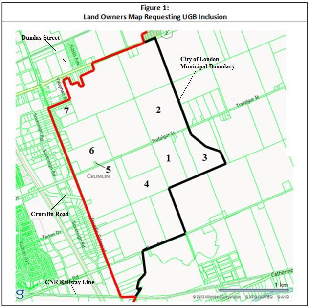
Historical Record Since Vision ’96 / Final
Approval of OPA #88
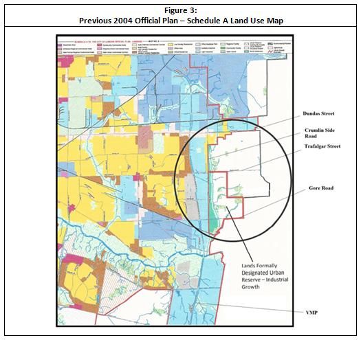
Post 1993 annexed lands, particularly East London, received an Urban Reserve-
Industrial Growth designation for lands east of Crumlin Road, between
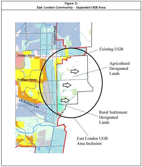
Trafalgar Street, south to the CN railway line, note Figure 2.
The re-inclusion of these lands within the Urban Growth Boundary (UGB)
are part of our firm’s presentation.
During the 2005 period, request was made to the then Planning Committee, by
the Crumlin Road Homeowners Association, other individual property owners
and our firm (through the representation of a former client) to replace the
then-existing:
Urban Reserve – Industrial Growth designation to Urban Reserve –
Community Growth.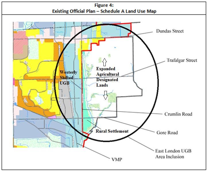
Planning staff recommended and Council approved the following:
Westerly shift of the UGB line to Crumlin Rd;
Removal of the Urban Reserve – Industrial Growth designation for lands
south of Trafalgar Street, east of Crumlin Rd. and north of the CN
railway line;
Re-designation of this area to Agricultural and Rural Settlement, along
the east side of Crumlin Rd., note Figure 4.
During the initial phase of this current 2011 OP Review Process, our firm
introduced to the June 30, 2012 Strategic Priorities and Policy Committee a
petition of 25 East London land owners (which was assembled by Mr. Lou
Flannigan, a still participating land owner ) in request of this same UGB
inclusion.
This evening’s presentation is consistent with what the Committee heard at
the July 23, 2013 public meeting regarding the initial Terms of Reference
Outcome of Staff Recommendation and City
Council’s 2005 Decision
East London lost Urban Growth lands that were obtained from the original
Vision 96 / OPA-88 process
East London land owners and Community Association were not listened to
in swapping the former Urban Reserve-Industrial Growth to Community
Growth
Subject Area was down-designated
East London has yet to regain Urban Growth lands, while other areas of the
City have not faced any reductions since the approval of OPA-88
R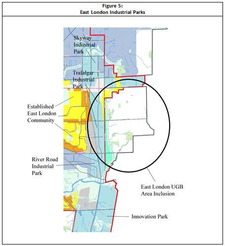
Justification for a UGB Expansion and Establishment of
an Urban Reserve - Community Growth Designation
Longstanding pent-up demand exists for Community Growth lands in East
London
This shortage of immediately developable residential properties has caused
unnecessary increases in cost of the remaining short supply of raw land
There is now a noticeable lack of readily available diversified new housing,
which East Londoners urgently require, in terms of size, mix and price
range.
Logical extension of the existing residential community exists south of
Dundas Street, east of Crumlin Road and north of the CN railway line
R The VMP employment corridor that extends from Huron Street to Highway 401
is largely developed within the following Industrial Parks, as noted in Figure 5:
Skyway Industrial Park
Trafalgar Industrial Park
River Road Industrial Park
Innovation Park
Which currently has and there is potential to greatly expand homeowners
living in close proximity to their places of employment east of the VMP, ideally
greenfield lands east of Crumlin Road
This form of employment/ residential interface lands is one of the key
aspects of New Urbanism for our cities, because it reduces the use of
automobiles, creates less pollution and sprawl , encourages public transit,
use of bicycles, walking and compact urban growth and intensification. R At the same time, the existing employment facilities and future anticipated
industrial expansion along the VMP will continue the trend of creating low
levels of pollution because it is not a heavy manufacturing corridor.
Rather, this subject Parkway is geared to office business park, light
manufacturing, high-tech and warehousing/distribution industrial uses.
R The VMP and Highway 401 provide rapid in-City and Regional connections to
both employment and commerce towards the Toronto Centred Region.
Existing arterial and collector roads are in place.
Municipal servicing exists along Trafalgar St., Admiral Dr. and Dundas St.,
beyond the VMP and on Dundas St. to Crumlin Rd.
Water services extend the full length on Crumlin Rd. from Dundas St.,
south to the CN railway line .
Existing fire hall, ambulance station, library, and new proposed recreation
centre will be able to accommodate significantly expanded residential
development.
The requested lands for UGB inclusion are within a five minute
response/travel time of these essential services.
In addition, relatively new existing schools are experiencing a decline in
enrollment
R Existing commercial district along Dundas St. from Highbury Avenue to Argyle
Mall requires supportive/new residential development.
Discussions with the Argyle Business Improvement Association (BIA)
confirms the above, note submitted letter of support
New residential development will provide the City with additional assessment
and funds for the extension of municipal services.
No private sector development competition exists within the existing East
London community for additional residential development.
The last major residential development in East London occurred north of
Gore Rd. and west of the VMP (i.e. late 1980s to early 1990s).
Requested East London UGB inclusion will not create a precedent.
R The impact of Fanshawe College`s continuous growth will systematically
expand East London’s skilled trades workforce, which is an important draw for
investors beyond the City of London to locate new industrial related jobs in the
area and in turn generate the need for additional housing .
All of the previous supportive arguments will provide a counterbalance to the
loss of population, residential development and tax base that has now been
relocated within adjacent satellite communities, such as Dorchester and
Thamesford, which presents an unfavorable economic situation for East
London and the overall City of London.
As a result, out-migration has encouraged low-density suburban sprawl to
leapfrog into satellite communities, rather than be contained in a regional
city, such as London, which can accommodate sustained growth.
RPopulation Trends for East London between
2006 and 2011
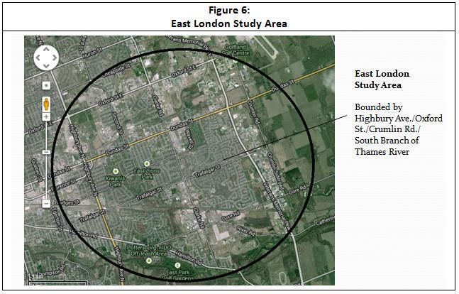
East London socioeconomic and housing statistics, which support an expanded
UGB, are based on an East London study area, bounded by Highbury Ave.
/Oxford St./Crumlin Rd./South Branch of Thames River, as can be noted in
Figure 6.
East London’s population declined by 3.03% within the above timeframe,
which amounted to a loss of 1,403 people (i.e. from 46,362 to 44,959) (Tetrad,
2013).
This population decline in the East London area is primarily due to the
migration of residents to newly developed housing in Northwest, West and
Southwest London, and beyond London’s boundaries to Thames Centre,
Middlesex Centre and both Oxford & Elgin Counties, where residential
expansion has been accommodated.
In addition, there is a significant change in East London’s family structure
where there is a noticeable decline in young families and a growing aging
population.
R The population of the City has grown from approximately 353,000 in 2006 to
roughly 367,000 today, demonstrating that the declining population trends in
East London are not consistent with overall City trends.
Retail and office uses, primarily within the Dundas St. corridor, are
experiencing higher vacancies, as a result of a decline in population and
residential growth in the area.
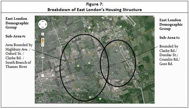
R Breakdown of East London’s Housing Structure
East London’s housing structure can be broken down into two sub-areas, as
noted in the following and depicted in Figure 7:
Sub-Area #1: Area Bounded by Highbury Ave. / Oxford St. /
Clarke Rd. / South Branch of Thames River:
Primarily comprised of single-detached homes (i.e. 62% of the total
housing supply), as compared to the overall City of London average of
57% (GeoWarehouse, 2013).
55% of the homes in this area are between 26 and 60 years old, which is 5
to 7% more than the City average (GeoWarehouse, 2013).
10% of the homes in this area are between 11 and 25 years old, while the
City average is 25% (GeoWarehouse, 2013).
It should be noted that the principle reasons why East London possesses
an above-average percentage of single detached homes and older age of
the existing house stock is due to the lack of new dwellings.
R Sub-Area #2: Bounded by Clarke Rd./ Dundas St./ Crumlin
Rd./Gore Rd.:
Primarily comprised of single-detached homes (i.e. 55% of the total
housing supply), as compared to the City of London average of 57%.
50% of the homes in this area are between 26 and 60 years old
(GeoWarehouse, 2013).
37.5% of the homes in this area are between 11 and 25 years old, while the
City average is 25% (GeoWarehouse, 2013).
It should be noted that the latter statistic is reflective of the last major
wave of residential development from the late 1980s to early 1990s,
where there was a readily available supply of raw land for suburban
growth, prior to the introduction of the UGB, through the approval of
Vision ‘96/OPA #88 in 1999.
Thus, these above statistics demonstrate that East London was able to
both compete and outpace the City average, in terms of housing mix
and age of dwellings, when there was an overall supply of readily
developable land for development.
RSummary Observations
During this current City of London 2011 Official Plan Review process, there is
concrete planning justification for East London to finally be recognised as an area in
need of UGB lands for Community Growth, based on the following rationale:
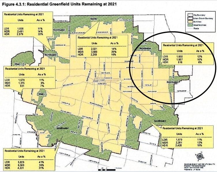
The recently completed Land Needs Background Study, which was presented at
the July 23, 2013 public meeting before this Committee, has incorrectly depicted
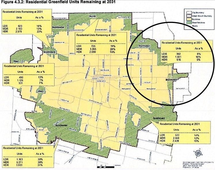
the East London area in Figures 4.3.1 and 4.32 (Residential Greenfield Units
Remaining at 2021 and 2031), as depicted below:
Grouped both Community and Industrial Growth Lands together; thus
difficult to distinguish between them
East London area, south of Dundas Street, has been identified as Northeast
London; thus potentially leading one to believe that East London has ample
Community Growth lands, based on the projections within Table 4.3, when
there is not an existing oversupply
Area between Huron and Oxford Streets, east of the VMP (designated as
Industrial) appears to be identified as future Community Growth lands with
identified projections within Figures 4.3.1 and 4.3.2
R Subject request is within an area that has lacked new residential
development since the early 1990s.
Subject request is beyond ultimately serving the interests of existing
land owners and the land development industry
Rather, there is an urgent need for new community growth, in order
to support the existing residential built form, commercial areas and
overall East London community. The present trend of East London suffering depopulation will only
increase, which will gradually cause the following:
Decrease in the values of commercial properties and buildings;
Decrease in retail activity;
Stagnant municipal assessment;
Need for future possible municipal financial incentives, to address social
and infrastructural requirements, could be lessened if free market forces
would be allowed to prevail through natural growth of its residential
population.
If there is flexibility from other developers/land owners who wish to
remove existing UGB land tracks because they face long-term servicing and
development windows
R These same developers/land owners can invest in an expanded East
London UGB, which can provide a short-term development window,
where there is already a pent-up demand for new housing
East London should not continue to be unfairly targeted as the sole District
for intensification, primarily via the former Psychiatric Hospital lands,
while London’s other three Districts continue to have significant existing
and possibly expanded greenfield lands for Community Growth
The East London area is a unique District for UGB expansion, which does
not mirror any of the other three areas of London, in terms of need and
justification
RYou can also read